Article

Deploying a GIS-Based Multi-Criteria Evaluation (MCE) Decision Rule for Site Selection of Desalination Plants

1
Department of Environment, Faculty of Natural Resources & Marine Sciences (FNRMS), Tarbiat Modares University (TMU), Noor 46414-356, Iran
2
Deputy of Marine Environment & Wetlands, Department of Environment, Tehran 14155-7383, Iran
3
Estonian Marine Institute, University of Tartu, Mäealuse 14, 12618 Tallinn, Estonia
*
Author to whom correspondence should be addressed.
Submission received: 28 February 2022 / Revised: 16 May 2022 / Accepted: 20 May 2022 / Published: 23 May 2022
(This article belongs to the Section Oceans and Coastal Zones)

Abstract

:
Water supply is one of the most critical infrastructures for development, and by desalinating the water of the Persian Gulf, water demands may be satisfied. The countries of the Persian Gulf basin have applied this technology and compensated for the country’s water shortage, whereas because of Iran’s unlimited access to water, desalination has only been applied on a local scale. Due to serious hydrological stress and periodic water shortages in Iran’s southern coastal area, seawater desalination may be necessary as an optional solution for water supply. Site selection for desalination plants is difficult as it may have a direct influence on the territorial and water environment, as well as disrupt biological systems, hence, the objective of this study was to identify desalination sites across the coastline of Hormozgan. To choose a suitable site, a multi-criteria evaluation (MCE) design was applied, with three scenarios evaluated in the constraints part and two scenarios considered in the criteria weight section. Altogether, out of 21 determination criteria considered for the construction of desalination facilities, 14 were associated to the inland and coastal segment, six with the marine zone, and one with the water quality phase. The results showed that about 33,584 ha in the optimal scenario, or when minimum and maximum constraints were applied, approximately 109,553 and 7182 ha, respectively, of the region, including a total of 11 zones, were suitable for the building of desalination facilities. In conclusion, this study was the first to consider MCE with many criteria and different scenarios for developing a decision rule for the installation of desalination facilities based on environmental and marine factors.

Graphical Abstract

1. Introduction

Although water covers more than 70% of our world, 97% of it exists in the sea, and just 3% of it is drinkable or reasonable for other household purposes. Water scarcity has been gradually growing in most of the world’s major cities over the last few decades; population growth, climate change, industrialization, shifting usage habits, improved living standards, and the enhancement of irrigated agriculture [1] are the principal motivating factors behind this rise in water demand, and it is anticipated that it will aggravate the world’s water crisis [2,3]. In many places of the world, we still have problems and challenges with water quality protection and correct use. Due to Iran’s geographical position in arid and semi-arid areas [4], water scarcity could be a regional fact in most districts of the nation. According to the cases noted, Iran’s low rainfall pattern, reduced groundwater level, and decreased rainfall due to climate change are causing a crisis and water stress. However, there is capacity for high renewable water supplies along the coastline in the north and south of the country that can enable the country to respond to water shortage conditions. One of Iran’s most significant challenges in the current period is obtaining sufficient and fresh water.
Recycling effluents, rainwater collection, bottled water, and cross-country pipelines are some of the alternatives. There are advantages and disadvantages to each of these strategies. Desalination is a low-cost approach of supplying drinking water to places where there is water scarcity. Desalination is the most well-known method arising from changes in both the availability and demand for freshwater supplies, both of which are anticipated to increase exponentially in future years [5]. One of the most promising techniques to deal with water shortages is desalination which converts mildly saline or seawater to drinkable freshwater [6,7,8].
In terms of sea areas, the largest number of desalination plants exist in the Gulf with a total seawater desalination capacity of approximately 12.1 Mm3/d—or about 44% of the worldwide daily production. The largest producers of desalinated water in the Gulf (and worldwide) are Saudi Arabia (25% of the worldwide seawater desalination capacity, of which 11% are in the Gulf region, 12% in the Red Sea region, and 2% in unknown locations), the United Arab Emirates (23% of the worldwide seawater desalination capacity), and Kuwait (6%) [9].
Access to appropriate and sustainable water resources is one of the most important factors for a country’s long-term development. This is especially critical in the Middle East and countries surrounding the Persian Gulf because of its placement in the world’s dry belt. Desalination is one of the human techniques to deal with a water shortage, and it is a technology that the Arab countries of the Persian Gulf have employed to supply water. Despite its unlimited access to seawater in the Persian Gulf and the Sea of Oman and the great potential for water desalination, Iran has not been effective at using it, and continues to have water shortages and secondary issues, making a barrier to increasing economic progress. Despite the high efficiency of water desalination, finding a suitable location for desalination plants is one of the most difficult challenges facing water basin planners and managers. They must, in accordance with the principle of low-consequence development, inflict the least environmental damage on the environment, and at the same time, take into account future needs in accordance with the framework of sustainable development without destroying resources.
Many studies have been conducted around the world and in Iran to develop optimal methodology and to identify the most suitable sites for desalination. There have been studies on the selection of suitable sites for desalination plants, which include solar desalination plants in Turkey [10] and Egypt [11], desalination plants in Iran [4], groundwater solar desalination in Egypt [12], a desalination plant in Libya [13], wastewater aquifer recharge sites in Tunisia [14], solar desalination plant in Iran [15], a desalination plant site in Pakistan [16], desalination plants in eleven countries [17], a desalination plant in United Arab Emirates (UAE) [18], and a seawater desalination plant in Oman [19].
The literature review showed that, overall, in developed countries several studies have recently been conducted in the field of desalination plants, which are based on economic criteria and related to the energy segment. Under the criteria’s ranking, executive projects in the field of launching desalination plants were eventually implemented. Despite all the efforts made thus far, no comprehensive decision law or spatial model for locating marine desalination sites has been devised. Therefore, in the present study, in addition to considering various criteria, including environmental and economic criteria in the coastal and marine segments, a decision rule was formulated based on multi-criteria evaluation (MCE) modelling for the region.
The present paper prepares a spatial decision support system (DSS) for appropriate site selection through a comprehensive analysis approach using geographical information systems (GIS) as a tool in combination with the multi-criteria evaluation (MCE) method; using the weighted linear combination (WLC) method as a kind of MCE, an Analytical Hierarchy Process (AHP) is used to achieve sustainable development. According to the desalination planning phase in Hormozgan province, there is a need for appropriate site selection that can be used for current and potential needs based on decision rules and MCE to decide suitable desalination sites. This novel approach is described in this paper.

2. Materials and Methods
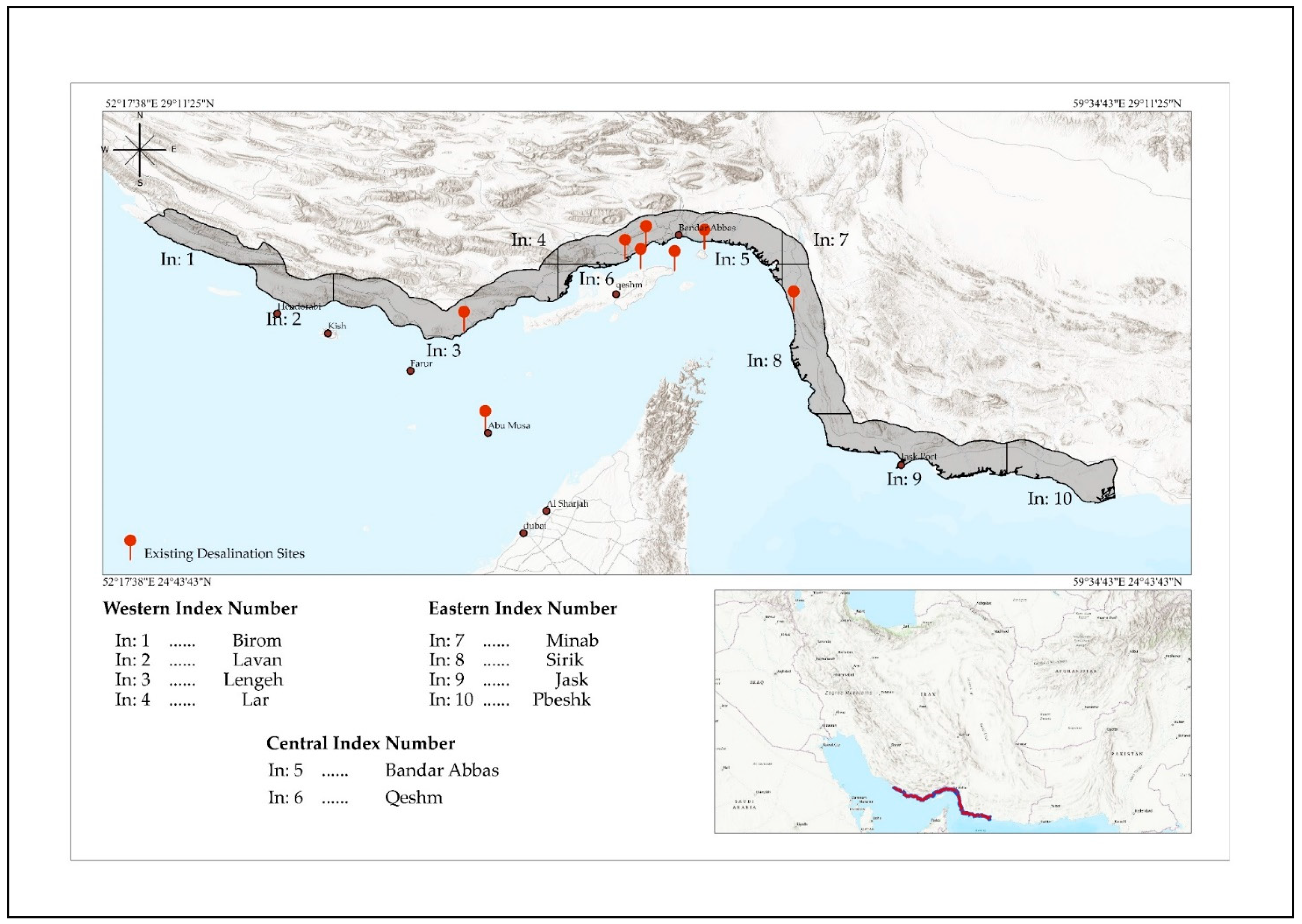
2.1. Case Study

Hormozgan province is located between the geographical coordinates of 25°24′ to 28°57′ N latitude and 53°41′ to 59°15′ E longitude of the Greenwich meridian (Figure 1). This province is in the south of Iran and to the north of the Strait of Hormoz, is approximately 68,000 km2 in area, and the length of its coastline is 900 km. The coast of this province along the east of the Sea of Oman and in the west of the Persian Gulf, and it is one of the important provinces of Iran that has suffered from water shortage.
To facilitate the analysis of the results, the Index map of the National Cartographic Center’s standard delineation procedure was used. In total, there are 10 Indexes in the region (Figure 1), based on which the region was divided into three parts, including western, central, and eastern. Figure 2 illustrates a stepwise process for conducting desalination research on the Hormozgan coast, every one of the steps will be mentioned in the subsequent sections.

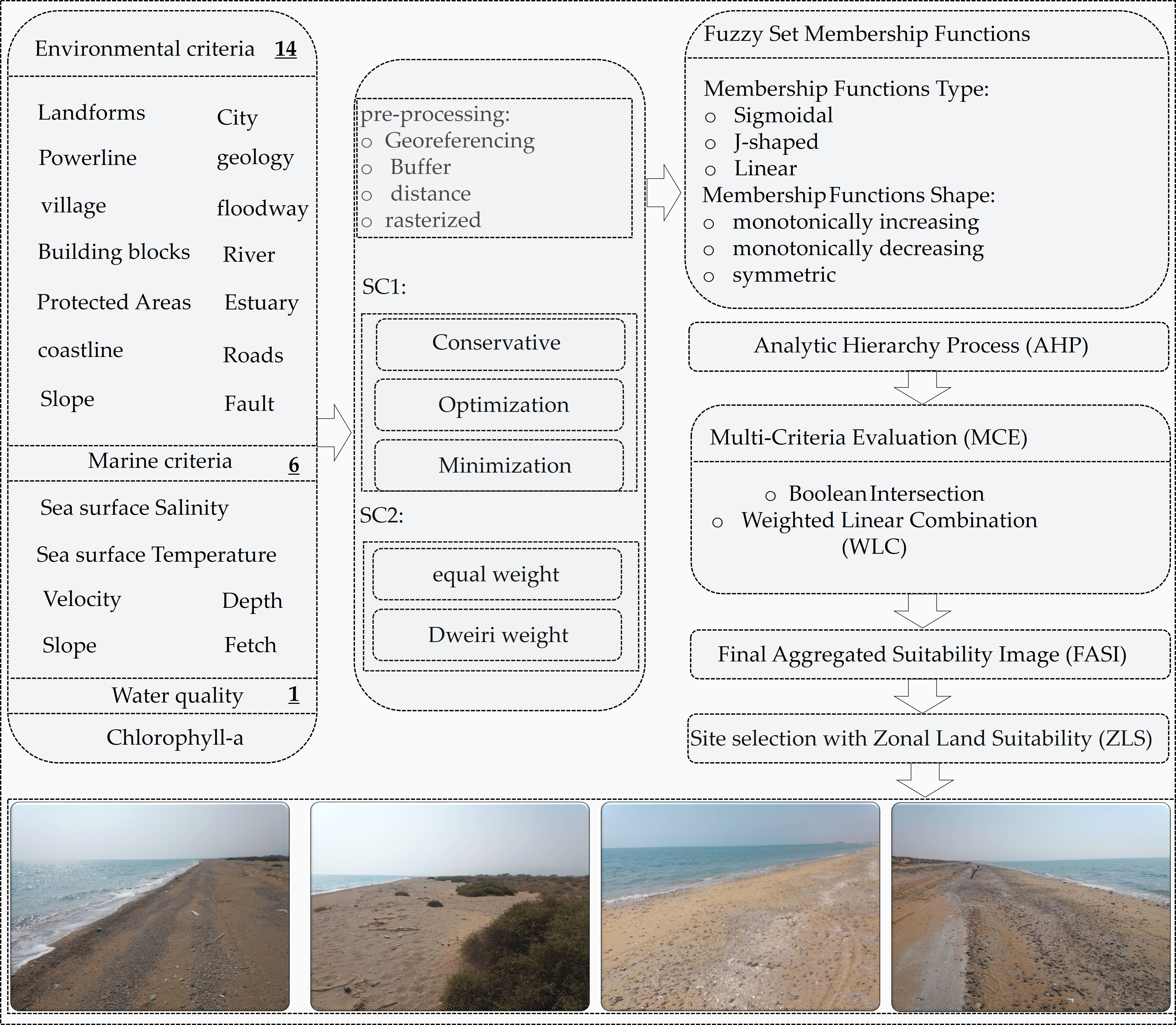
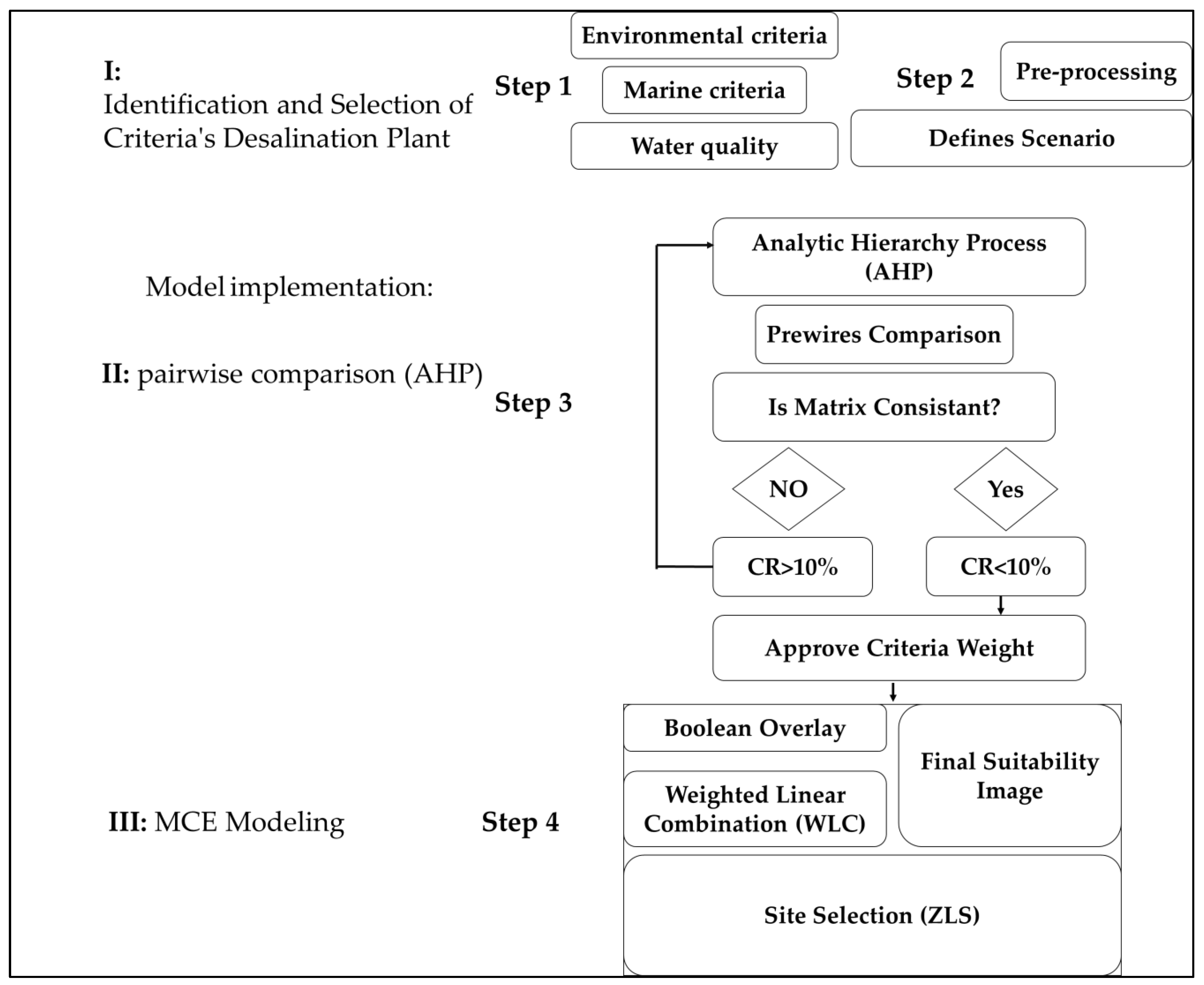
2.2. Identification and Selection of Criteria for Desalination Plant Sites

In this section, on the one hand, the environmental, marine, and water quality criteria are categorized into three components for choosing the suitable criteria for the site selection of desalination plants, and on the other hand, the necessary pre-processing is done. Based on the literature review, expert theory, and the regional characteristics, the required data for site selection for desalination plants are selected and grouped into 21 criteria and three major groups. As a project’s economic and environmental factors are critical [20], this research also considered them (Table 1).
Pre-processing operations on the data in the GIS environment were carried out at this step, inclusive of geometric correction and geocoding, creating a buffer and a map of distance (which includes proximity functions and calculates the shortest distance of each point on the map from a phenomenon or a set of phenomena); the layers were then prepared for modelling. Standardizations was done to convert different computational units of factors into comparable values. The selection of membership functions required for standardization was related to the user’s information about how changes affected the suitability of each factor. In this method, all factors in the continuous scale of suitability were standardized, and it was possible to combine all the values of the factors [21].

2.3. Model Implementation: Pairwise Comparison Using the Analytical Hierarchy Process (AHP)

The pairwise comparison approach, based on expert theory, is one of the most often used methods for estimating the weight of criteria [22]. The Analytical Hierarchy Process solves them by structuring issues in a hierarchical format. This method has been used to evaluate or rank a set of options so that the most suitable options can be selected [21]. In Saaty’s method, weighting is done in a continuous scale consisting of nine points, and each of these numbers represents a degree of importance so that the value of “1” indicates “equal importance” and the value of “9” indicates “extremely high” importance of one indicator relative to another [21]. The consistency ratio (CR) index is used to determine whether a judgment is acceptable. If the value is greater than 0.1, a pairwise comparison must be performed again; otherwise, the comparison matrix is considered to be consistent [23].
For the weight of a criterion, two scenarios were investigated. The first scenario assigned equal weight (Sc1) to all criteria, whereas the second scenario (Sc2) assigned the weight to factors based on the Deweiri et al.’s method [18].

2.4. MCE Modelling

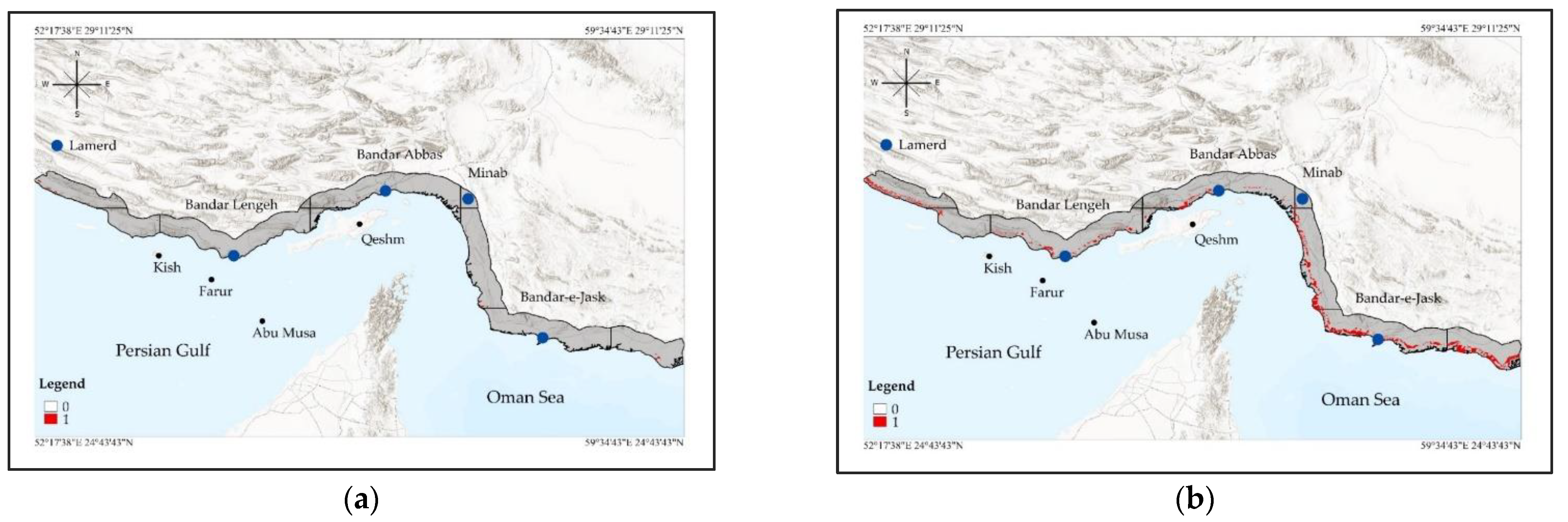
2.4.1. Boolean Method

To identify the best and generally legitimate scenario for the research area, factors and constraints were applied in three modes, including conservative (C), minimization (M), and optimization (O), which are the research area’s maximum, minimum, and optimal scenarios based on trial and error, respectively. The optimum scenario for the region was determined by analysing the optimal scenario between the C and M modes in terms of performance and outcomes.

2.4.2. WLC Method

In this method, the factor’s weight, and constraints on the criteria were applied. First, all criteria were multiplied by the factor’s weight (compensation weight) [24]:
S = W i X i
where S represents the suitability, Wi represents the weight of the factor I, and Xi is the criterion score in factor i. Then by multiplying the results of the constraint, the areas with zero values were eliminated, and only the suitability areas remained.
S = W i X i × C j
where Cj represents the score for constraint j, and ∏ is the product of multiplying the constraint.
This method is characterized by a full trade-off (1) between the factors and risk levels of 0.5 in the strategic decision space.

2.5. Site Selection

As inputs to the site selection phase, the output suitability map of the area covered by the weighted linear model was employed. Two common methods of site selection are ranking (sorting cells of the network based on suitability in descending order and selecting of cells with the highest value of suitability) and zonal land suitability (ZLS) [25]. In the ZLS method, cells are firstly selected based on the threshold of the required area. Then, the amount of zonal land suitability (average suitability of the constituent cells of each zone) is calculated. Further, the zones are arranged based on the value of zonal land suitability, and ultimately the zones with the highest suitability are selected [24]:
S z = L i z n z
where Sz = zonal land suitability, (Li)z = local suitability of the cell i belonging to the zone z, nz = number of cells forming z zones.

3. Results

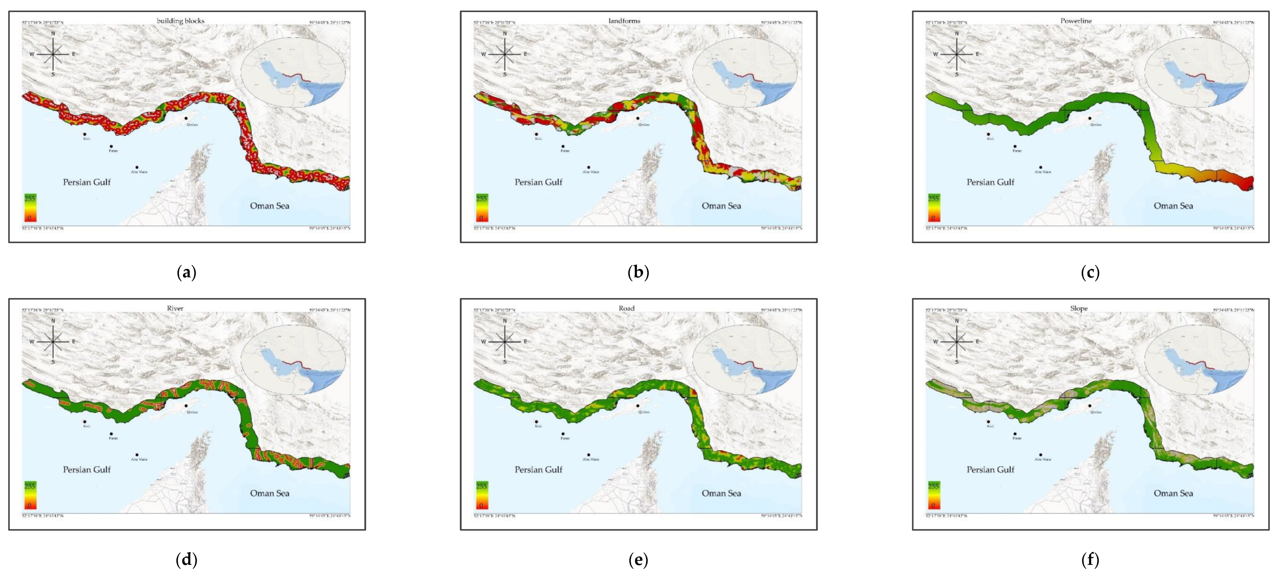
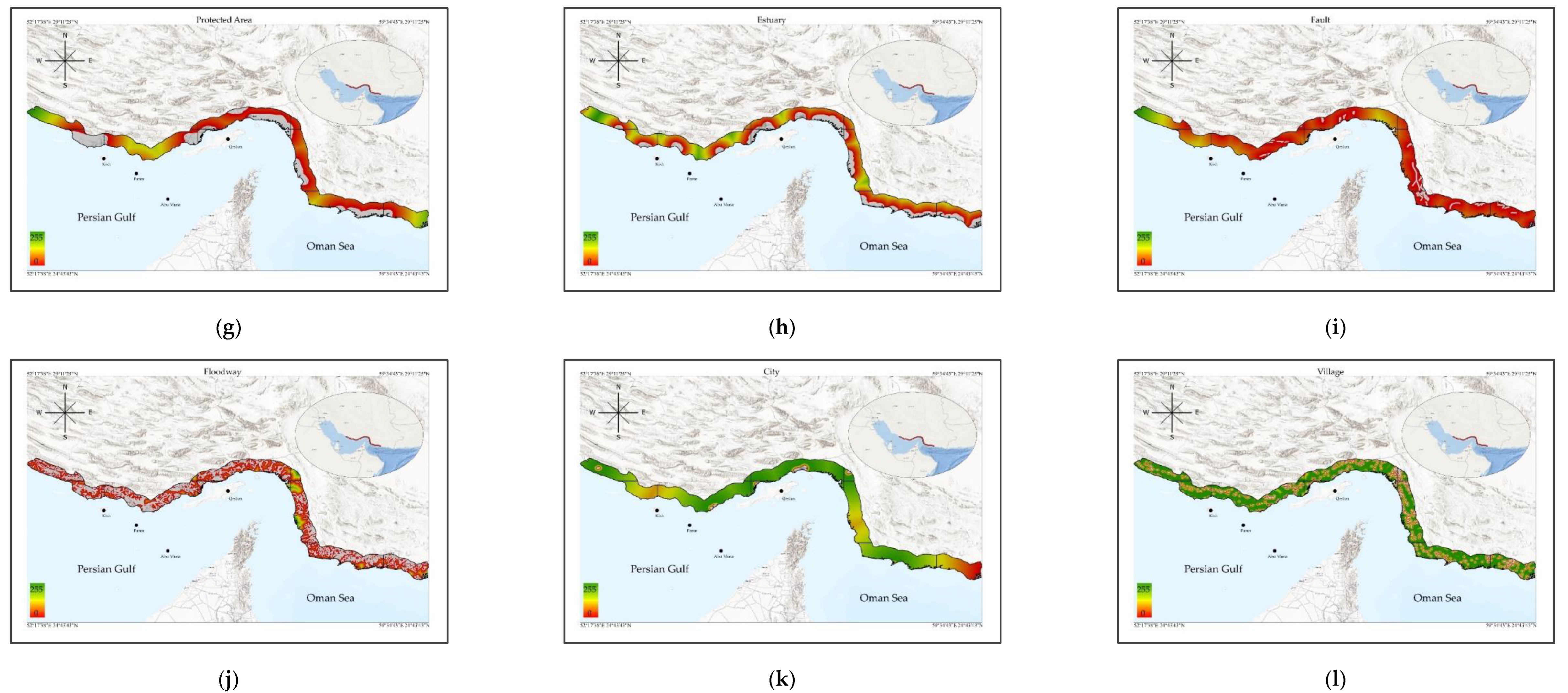
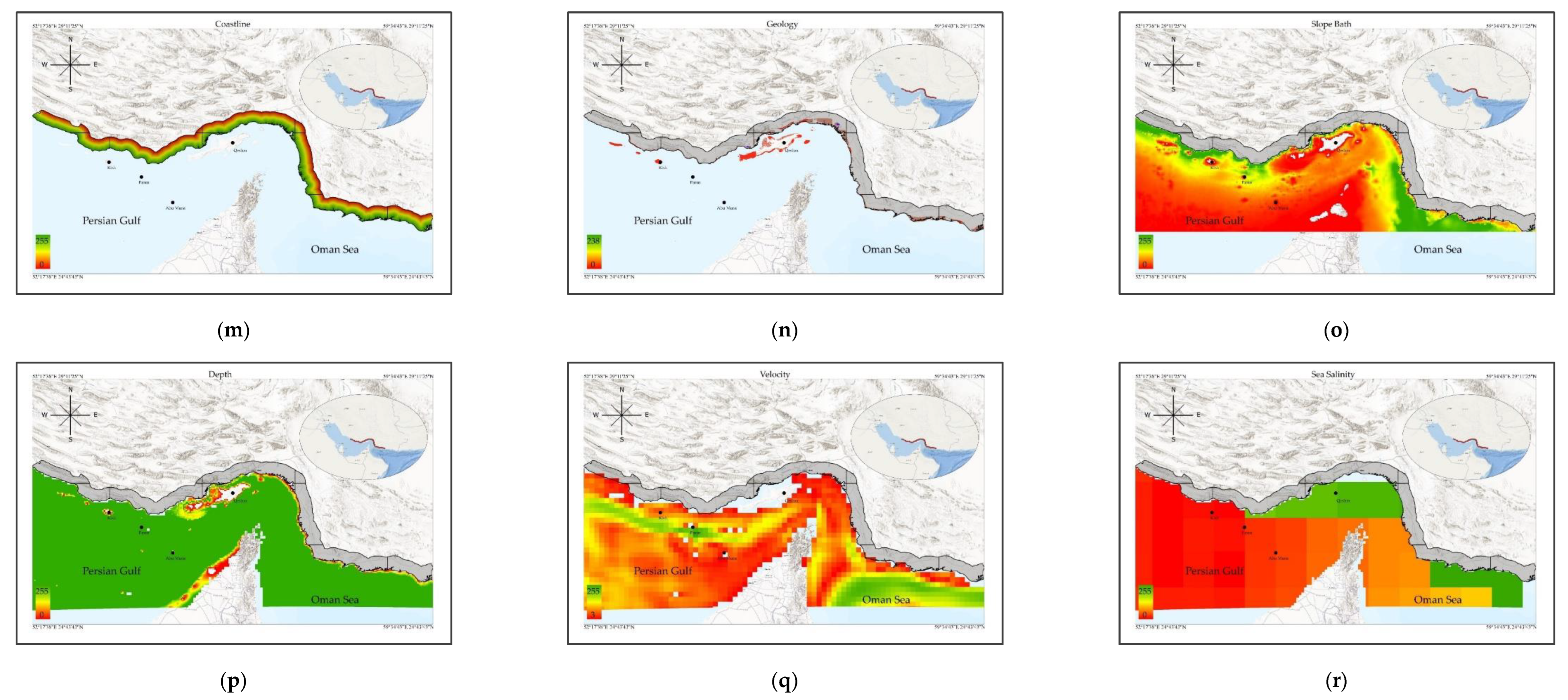
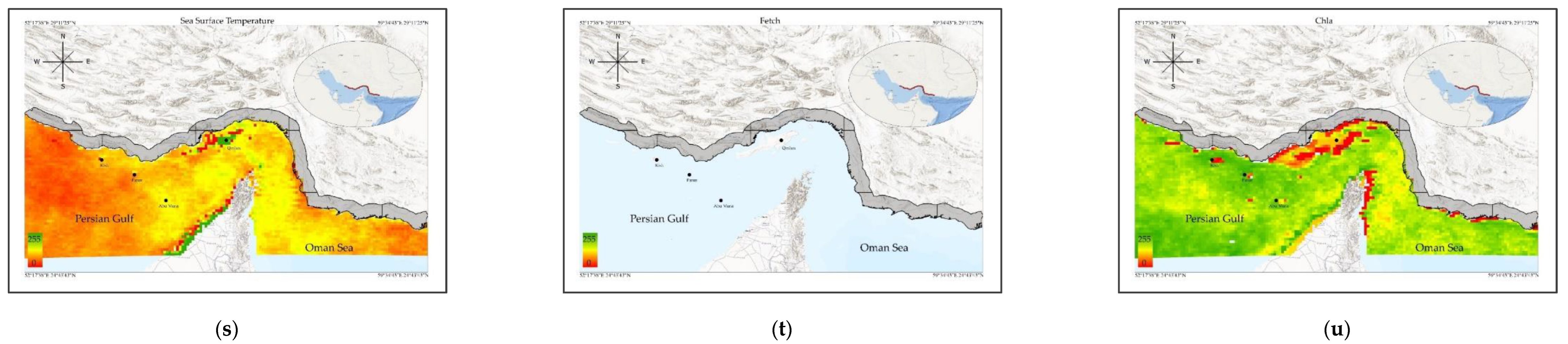
3.1. Fuzzy Membership Function Criteria

In this section, fuzzy membership functions have been used to standardize the criteria. The standardization of the decision rule’s factors are presented in Table 2.
The suitability area of each Index area based on each factor is shown in Figure 3 and Table 3. The whole region is highly suitable in terms of the river factor, which shows that there is a low density of rivers across the region, but the suitability of floodways is the least suitable, indicating the presence of a significant number of floodways in the research area.
According to the literature review, the criteria for desalination plants have not been studied yet. As a result, the control factors used for the implementation of similar industries were used through trial and error and various modelling to finally obtain the optimal conditions for the study area (Table 2).
Nevertheless, because of the low density of floodways in the Minab Index of the region (Index number: 7), the situation was relatively satisfactory. The lowest average suitability in the study area was related to the eastern area (Index number: 7), while the highest average suitability in the western area of the study area, was related to Bandar Lengeh (Index number: 3) (235) (Table 3). In terms of coastline, the region’s middle portion had the highest appropriateness, while the western portion had the lowest suitability.
In terms of slope criteria, Pbeshk (Index number: 10) and Lar (Index number: 4) had the highest and lowest suitability, respectively. The highest and lowest values for the chlorophyll criterion were related to Lavan (Index number: 2) and Bandar Abbas (Index number: 5), respectively. In terms of two marine criteria, temperature, and water surface salinity, Lavan (Index number: 2) had the lowest suitability, and the highest suitability for surface water temperature was related to Bandar Abbas (Index number: 5), and for surface water salinity was related to Qeshm (Index number: 6) (Table 3).
In summary, the maximum suitability area was seen in the two index areas (Birom and Sirik) of the western and eastern regions after applying the constraint, while the least suitable area was observed in the central regions (i.e., the two index areas of Qeshm and Bandar Abbas). The highest and lowest appropriate regions in the region, respectively, were 75.88% for the Minab Index area in the eastern part of the region and 13.76% of the Bayram Index area in the western part of the territory, according to the landform criterion (Table 3). The Slope criterion for coastal areas in the two index areas of Pibeshk and Lar had the highest (93.25% of the index area) and the lowest (16.29% of the index area) suitable areas, respectively. In the Lar and Minab Index areas, the maximum appropriate area (100% of the index area) was computed, but the lowest suitable area was obtained in the Jask Index (90.66% of the index area). Due to the high concertation of floodways (Figure 3), most of the Bandar Lengeh Index area lost its suitability for a desalination facility, whereas just 2% of the Lar Index area lost its suitability (Table 3). Fully 100% of the area of the eastern (Lar, Sirik, and Pbeshk) and western (Lavan) index areas in terms of distance from the city, and in terms of the two criteria of distance from building blocks and villages (Lar Index), the distance from the road (Minab Index), the distance from the powerlines (west–Birom, Lavan and Lar index areas, and east–Minab, Jask and Pbeshk index areas), the distance from the fault (Lavan, Qeshm and Minab index areas, 100%), the distance from the estuarine area (Lar Index 100%), the distance from the protected area (Lar and Bayrome index areas 100%) have the most suitable area for desalinisation plants. This was in spite of lower values for the two criteria of city (91.17%) and village (64.06%) in Minab Index, building blocks (Bandar Abbas Index 77.20%), roads in the Bandar Lengeh Index (84.25%), powerlines in the Qeshm Index (96.18%), fault in the Lar Index (89.12%); the two criteria of estuary and protected area of Qeshm Index have the least suitable areas.

3.2. Model Implementation

3.2.1. Boolean Modelling

The regional areas suitable for conservative (C-Mode)—approximately 7182 ha (Figure 4a), minimization (M-Mode)—approximately 109,553 ha (Figure 4b), and optimization state (O-Mode)—approximately 33,584 ha (Figure 4c), were determined in this modelling. In terms of the floodway criterion, shifting from C-Mode to M-Mode decreased the suitable area for this factor in the overall study region from 65% to 20%, while the O-Mode increased to 55%. In general, the rate of suitability in the region was increased from C-Mode to m-mode and from M-Mode to O-Mode at 783 ha and 176 ha, respectively.

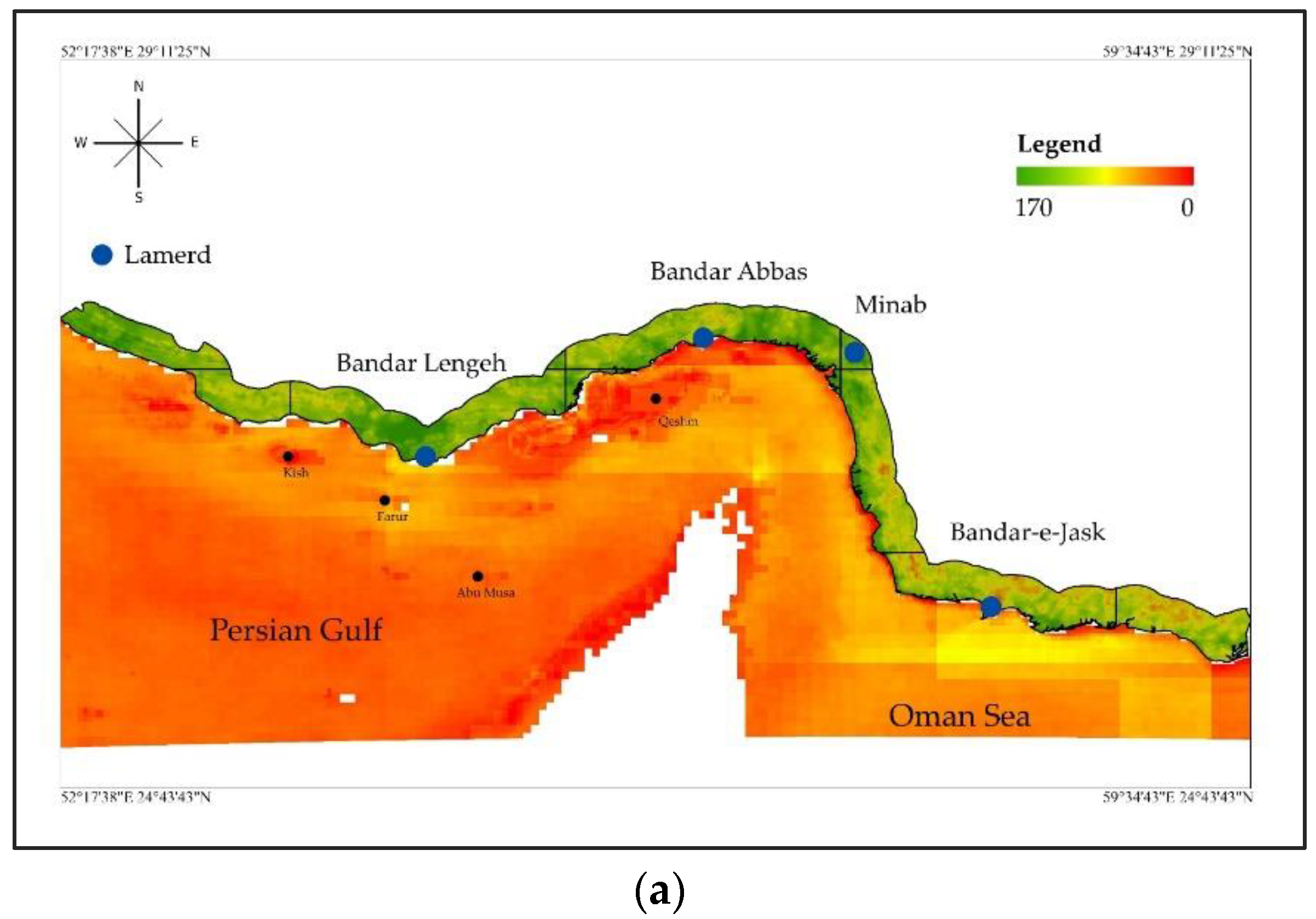
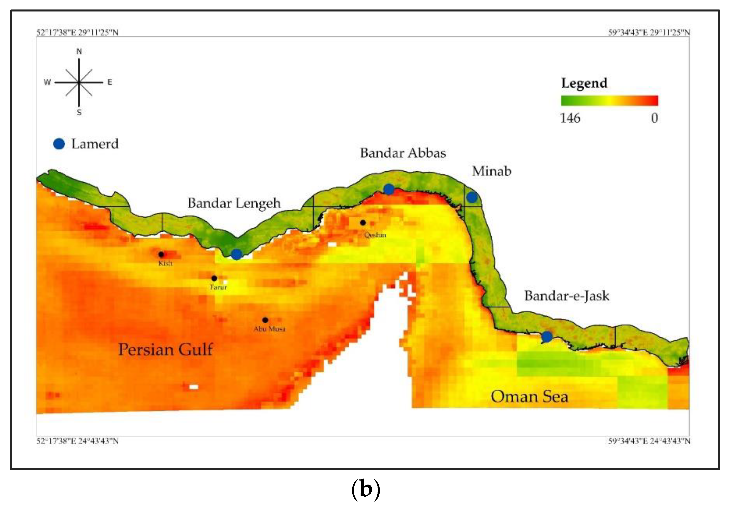
3.2.2. Final Aggregated Suitability Image (FASI)

Figure 5 depicts the FASI results for the two scenarios of giving equal weight to all of the criteria and weights used by [18]. The suitability range in the O-Mode and in the first scenario weighting (equal weight) was 0 to 170, with zero being the minimal suitability in this scenario (Figure 5a). The region was categorized into five classes in terms of suitability (1–30, 30–60, 60–90, 90–120, and 120–170) to assess and present better findings for this section of the analysis. Based on this scenario, the minimum suitability in the area was calculated as approximately 40%. Therefore, the first class was removed, and the second class covered only 2.33% (40,156 ha). The Qeshm and Minab index areas had zero suitability, but the eastern part of the region had the highest area suitability (Jask and Pbeshk index areas), and in general, the suitability decreased from east to west based on the first class. About 62.60% of the space was taken up by the third category (1,083,135 ha). All the index areas were suitable for this category. The central part of the Bandar Abbas Index and the western part the Lavan and Bandar Lengeh index areas had the highest suitability area, and the lowest suitability area was in the whole region of the Qeshm Index. The fourth class covers 34.3% of the area (593,829 ha), the highest suitability in the Lar Index being 78.2% and the lowest suitability in the Jask Index of 0.1%, and the central (Qeshm), eastern (Minab), and western (Birom) regions were the most suited, according to the other indices. The fifth category covers 0.77% (13,259 ha), the most suitability of this category belongs to the Qeshm Index 7.86% (2482 ha) and then the Bandar Lengeh Index 1.25% (4380 ha).
The suitability range in Sc2 is 0 to 146 (Figure 5b), and the scenario’s lowest suitability is zero, like in the preceding scenario. The findings for this study in this situation were classified into five groups (0–30, 30–60, 60–90, 90–120, and 120–146). Because the minimal suitability in this categorization was 25, the first category was eliminated in this scenario. The second class contained 54.06% of the area with Jask Index (81.70%) having the highest suitability, followed by the Lavan (77.53%) and Pbeshk (74.62%) index areas, and the least suitable area was in the two index areas of Birom (18.92%) and Lar (3.68%). Unlike the preceding class, this third class, had the highest suitability related to the Lar and Birom index areas, and the lowest suitability belonged to the Jask Index. In general, this class covered 43.36% of the total area. Except for the Lar and Minab index areas, the fourth class was appropriate in all index areas, with the maximum suitability estimated in Birom as 17.60% (26,958 ha) and Qeshm Index as 4.37% (1380 ha) and the lowest suitability calculated in Lavan Index as 0.18% (207 ha). The fifth group covered a minor portion of the land which was 145 hectares, or 0.01% of the total land area (Bandar Lengeh, Qeshm, Birom, and Bandar Abbas index areas).

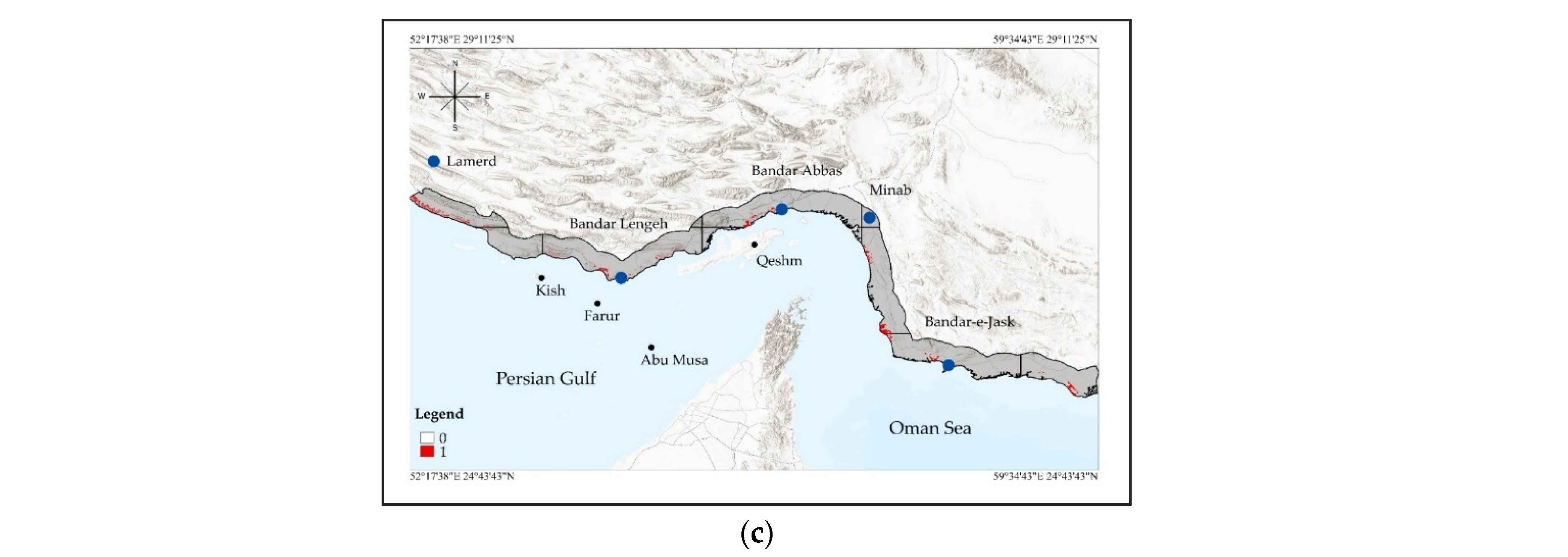
3.3. Site Selection by Boolean and WLC Approach by Zonal Land Suitability (ZLS)

The Boolean method only identifies suitable areas for the deployment of desalination facilities, but it does not prioritize among the selected sites. The best way to identify suitable sites for establishing desalination facilities used a ZLS method in the Boolean approach based on the C-Mode of 27 zones; this determined a total area of 7182 hectares with a minimum size of 50 hectares. The findings were calculated for the M-Mode, which included 225 zones covering a total area of 109,553 ha, as well as the O-Mode, which had 97 zones covering a total area of 33,584 ha. As shown in Table 2, the considered constraint was the most cautious mode in the C-Mode, which resulted in a significant reduction in the amount of residual area for a large number of factors. In this scenario, the floodway layer was distributed across a large portion of the region and many permanent and seasonal rivers exist in the region, the most important of which could be the Sadij river in the Pibeshk Index, the Jagin river in the Jask Index, the Jomahaleh in the Sirik Index, and the Hassan langi, Jalabi, and Kor in the Bandar Abbas Index. Several factors: estuaries are in a large part of the area with a buffer of 7000 m; 60 faults, most of which are in the east of the region, i.e., in the three index areas of Sirik, Jask, and Pibeshk with a buffer of 2000 m; there are 577 rural zones distributed in the area with a buffer of 2000 m; and the existence of seven urban areas in the study region with a buffer of 2000 m, led to the loss of a large area and only an area of 5264 ha was introduced in 27 zones. The amount of buffer considered according to Table 3 was first shifted to the minimization mode and subsequently to the optimization mode in the M-Mode and O-Mode. It expanded the acceptable space to 97,745 hectares in the M-Mode. Finally, the adjustment of the buffer resulted in an increase in appropriateness of 27,088 hectares in the study area’s various zones. Selected sites were examined in three areas including western, central, and eastern, as detailed further below.

3.3.1. Suggested Sites in the Eastern Part of the Region

Figure 6 depicts the locations of the four zones that were discovered in this area. In Zone A, the highest suitability and area of the site ware related to the third site, and the lowest suitability and area was related to the first and second sites, respectively. The average total depth in this area is 55 m (Table 4). Sites one and four in terms of distance from the estuary, site three in terms of distance from the protected area, and site four in terms of distance from the road and other criteria are in good condition for the desalination site.
The second site of Zone B has the least appropriateness in the western part of the region, while the first site of this zone has the largest area. In addition, the depth of the Persian Gulf around this zone is more than the other areas.
Zone C is more suitable and has a larger area than Zone D, although it has a shallower depth. The average minimum distance from the criteria of road and coastline, central population (city and village) were obtained in Zone A, B, and D, respectively. The highest suitability belongs to Zone C and the lowest suitability belongs to Zone B.

3.3.2. Suggested Sites in the Central Part of the Region

Zone E was located in the Bandar Abbas index (Figure 6), which has two sites with areas of 172 and 217 hectares (Table 5). The most significant estuaries are Chelkhoni, Chelsaudi, Mesaghe, Chel, and Naybandan, which are in the northern portion of the GNO protected area, the eastern half of the Hara, Tiab, and Minab, and the western part of the Hara-Qeshm protected area. The most major rivers near the zone are Shoor (seasonally situated in the eastern part) and Kor (permanently located in the western part). The first site’s southern portion is on the tidal shore and its northern part is on the coastal plain, whereas the second site’s southern part is on the coastal plain, its middle part is on the heights, and its northern part is on the floodplain.
The Bandar Abbas index includes Zone F as well as the previous zone. This site covers 2153 ha and is separated into three components in terms of landform, including tidal beach, mud zone, and flood plain, which are divided into southern, northern, western, and northeastern sections, respectively. In terms of distance from the river, building blocks, faults, and sensitive coastal regions, the data in Table 5 demonstrate that this site is in good condition. The Persian Gulf’s depth in this zone is around 20 m, which is lower than in other zones.

3.3.3. Suggested Sites in the Western Part of the Region

In the western part of the region, Bandar Lengeh Index covers Zones G, H, and I, whereas the Birom Index covers Zones J and K (Figure 6). The northern and central parts of the first and the second sites (Zone G) are on the flood plains, the southern and eastern parts of the first site are on the alluvial fan, and the southern parts of the second site is on the dune.
The areas of these two sites are 198 and 107 hectares (Table 6), respectively, which is better than the second site in terms of environmental criteria. The protected area of Faro and Hara-Khoran are in the southwestern part of the first site and the eastern part of the second site, respectively, and the only river close to the sites is the Sheikhi river, and there are two estuaries in the area between the two sites. The area and suitability of the first site is more than the second site.
The highest suitability (Zone H) is related to the first site and the lowest suitability is related to the second site. The area of this site, which is in the western part of the Siraj protected area, is 201 ha (Zone I) (Table 6). This site is in a good condition in terms of distance from the river, building block, estuary, distance from the coast, and faults. The Persian Gulf is approximately 20 m deep at this location. The landform on which this place is situated is the coastal plain. Each of the two western zones have two sites. The second site, Zone J, has the highest suitability in the western part of the region and in terms of the criteria under consideration, and the area of four sites has the potential to be selected for desalination facilities.

4. Discussion

The selection of suitable and acceptable sites for a desalination plant is subject to the consideration of technical, environmental, economic and social criteria and requirements [34]. Based on the results of Figure 6 and Table 3, such as for slope criteria, powerline, coastline and SST in the central part, in terms of distance from the road to the western part, chlorophyll and water salinity criteria have the highest potential because of access to free water in the eastern part of the region, dam releases in this area will be reduced as a result of this [12]. The Strait of Hormuz bounds the region’s central and western parts, causing saline conditions to advance and expand in the central and western part of region [12]. The distance from the road (transportation and infrastructure construction) [11,16,35,36], powerline (network connection costs) [11,37,38], coastline (transportation and installation cost) [38,39], population areas are important considerations. As there are no clear rules for installing desalination facilities in residential areas, the fuzzy membership function was developed by trial and error. The site of the desalination plant should be such that, on the one hand, it has the lowest cost to transmit water to human settlements; by installing desalination facilities near populated regions, many additional costs, such as the cost of water transfer [37], would be avoided. However, due to air, visual, and noise pollution, the plant location should not be too close to populated regions [34], hence the symmetric function was employed (Table 2), and slope (infrastructure construction) [27,37] in the coastal segment, as well as temperature and salinity in the marine section [10], and low chlorophyll [40] factors considered. Plankton and organisms might get stuck in the pump’s intake, causing problems [40] and have an impact on desalination facility implementation. The minimum distance for any development in the vicinity of a protected area, according to the environmental protection agency, is 2 km [37,41], therefore, due to the high sensitivity of the area and polluting industries and a significant rate of industrial development [42], especially in the western part of the area (Figure 3), for the estuary and protected region, a 7-km buffer was proposed (Table 2). Desalination facilities should have the lowest risk in terms of natural catastrophes which cause infrastructure destruction, such as earthquakes and floods [27], because they are present for a long time and it is not possible to move them owing to the high expense of doing so [4]. As a result, the potential area for the building of desalination plants was decreased due to the high density of floodways in the western half of the area (Figure 3).
In the section related to weighting and constraint scenarios, as expected, the weights [37,43,44,45,46,47] (Figure 5) and constraints [44] (Figure 4) related to the studied criteria affected the site selection process and the suitability of the area for building of desalination facilities. As a result, different scenarios were implemented in this section of the study [43]. These characteristics along with their related weights led to an increased suitability for the western, central, and eastern parts, respectively.
The current study is consistent with other studies [39,48] which focus on the energy sector and the type of technology employed [13,15,16,19], the AHP method [18], the Delphi method [30], the ELECTRE method [4], as well as studies in similar industries, such as coastal wind farms [35], solar power plants [49], and solar-powered desalination facilities [10,11]. Accordingly, this study was the first to consider MCE with a many criteria and different scenarios for developing a decision rule for the installation of desalination facilities based on environmental and marine factors.

5. Conclusions

Desalination is one of the most effective strategies to deal with the rising demand for water. Iran has the potential to develop desalination facilities due to the availability of free water in the country’s south. In the future, desalination will be a source of water for coastal towns in dry and semi-arid regions. Managers and decision makers must consider environmental and aquatic ecosystem components of sustainable development in addition to water availability. The goal of this study was to use multi-criteria assessment modelling to find potential sites for desalination plants in Iran to address the problem of water scarcity in the country’s south. In general, 14 environmental criteria, 6 marine criteria, and 1 water quality criterion were evaluated for decision makers to decide on the suitability of each criterion based on the environmental conditions of the region. Previous studies had limitations in terms of two important factors, first, was the use of ranking methods, second, they considered a limited number of criteria. The following are the major conclusions:
(1)
The development of a decision rule for the desalination facility site selection is one of the most significant accomplishments of this research. It was generated using the study area and various scenarios.
(2)
In addition to inland and coastal segment criteria, marine criteria were included in modelling to reduce the desalination plant’s negative environmental impacts.
(3)
In addition to meeting the study area’s water needs and shortages, the model’s results and output will assist regional managers and policymakers in applying the results and decision rule to other coastal provinces.
In conclusion, because the change of weight based on two scenarios can alter the suitability and output of the model, weight sensitivity analysis of criteria in future studies can be valuable in this sector.

Supplementary Materials

The following supporting information can be downloaded at: https://0-www-mdpi-com.brum.beds.ac.uk/article/10.3390/w14101669/s1.

Author Contributions

Conceptualization, M.G.; methodology, M.G.; software, B.A. and M.G.; validation, M.G., A.S., S.M. and T.K.; formal Analysis, B.A.; investigation, B.A. and M.G.; resources, B.A.; data curation, B.A.; writing—original draft preparation, B.A. and M.G.; writing—review and editing, M.G. and T.K.; visualization, B.A.; supervision, M.G.; project administration, M.G.; funding acquisition, T.K. All authors have read and agreed to the published version of the manuscript.

Funding

The study presented here is part of the project with these specifications: “Title: Zoning priorities of positioning seawater desalination installations in the coastal areas of the Persian Gulf and the sea of Oman (Phase 1: Hormozgan Province)”; “Client: Deputy of Marine Environment & Wetlands, Department of Environment (DOE), Iran”; “Consulting Firm: Tarbiat Modares University (TMU), Iran” “(Contract Number and Date: 97/173, 20 January 2019)”.

Institutional Review Board Statement

Not applicable.

Informed Consent Statement

Not applicable.

Acknowledgments

The authors extend their appreciation for the funding and support provided by the authorities of “Deputy of Marine Environment & Wetlands, Department of Environment (DOE), Iran” and “Tarbiat Modares University” in the implementation of this practical and important project. Tiit Kutser’s contribution was funded by the Estonian Research Council grant PUT PRG302. We also thank the anonymous reviewers for their constructive suggestions and comments. The official translation of the project approval letter from the client is provided as a Supplementary File.

Conflicts of Interest

The authors declare that there is no conflict of interest.

References

  1. Ercin, A.E.; Hoekstra, A.Y. Water footprint scenarios for 2050: A global analysis. Environ. Int. 2014, 64, 71–82. [Google Scholar] [CrossRef] [PubMed]
  2. Haddeland, I.; Heinke, J.; Biemans, H.; Eisner, S.; Flörke, M.; Hanasaki, N.; Konzmann, M.; Ludwig, F.; Masaki, Y.; Schewe, J.; et al. Global water resources affected by human interventions and climate change. Proc. Natl. Acad. Sci. USA 2014, 111, 3251–3256. [Google Scholar] [CrossRef] [Green Version]
  3. Schewe, J.; Heinke, J.; Gerten, D.; Haddeland, I.; Arnell, N.W.; Clark, D.B.; Dankers, R.; Eisner, S.; Fekete, B.M.; Colón-González, F.J.; et al. Multimodel assessment of water scarcity under climate change. Proc. Natl. Acad. Sci. USA 2014, 111, 3245–3250. [Google Scholar] [CrossRef] [PubMed] [Green Version]
  4. Mostafaeipour, A.; Saidi-Mehrabad, M.; Rezaei, M.; Qolipour, M. The ranking of southern ports and islands of Iran for seawater desalination plants using ELECTRE III method. J. Renew. Energy Environ. 2017, 4, 10–22. [Google Scholar]
  5. Bremere, I.; Kennedy, M.; Stikker, A.; Schippers, J. How water scarcity will effect the growth in the desalination market in the coming 25 years. Desalination 2001, 138, 7–15. [Google Scholar] [CrossRef]
  6. Grubert, E.A.; Stillwell, A.S.; Webber, M.E. Where does solar-aided seawater desalination make sense? A method for identifying sustainable sites. Desalination 2014, 339, 10–17. [Google Scholar]
  7. Salem, M.S.; El-Shazly, A.H.; Nady, N.; Elmarghany, M.R.; Sabry, M.N. PES/PVDF blend membrane and its composite with graphene nanoplates: Preparation, characterization, and water desalination via membrane distillation. Desalin. Water Treat 2019, 166, 9–23. [Google Scholar] [CrossRef]
  8. Ziolkowska, J.R. Is desalination affordable?—Regional cost and price analysis. Water Resour. Manag. 2015, 29, 1385–1397. [Google Scholar]
  9. El-Ghonemy, A. Future sustainable water desalination technologies for the Saudi Arabia: A review. Renew. Sustain. Energy Rev. 2012, 16, 6566. [Google Scholar] [CrossRef]
  10. Aydin, F.; Sarptas, H. Spatial assessment of site suitability for solar desalination plants: A case study of the coastal regions of Turkey. Clean Technol. Environ. Policy 2020, 22, 309–323. [Google Scholar] [CrossRef]
  11. Mohamed, S.A. Application of geo-spatial Analytical Hierarchy Process and multi-criteria analysis for site suitability of the desalination solar stations in Egypt. J. Afr. Earth Sci. 2020, 164, 103767. [Google Scholar] [CrossRef]
  12. Salim, M.G. Selection of groundwater sites in Egypt, using geographic information systems, for desalination by solar energy in order to reduce greenhouse gases. J. Adv. Res. 2012, 3, 11–19. [Google Scholar] [CrossRef] [Green Version]
  13. Badi, I.; Ballem, M.; Shetwan, A. Site selection of desalination plant in libya by using combinative distance-based assessment (codas) method. Int. J. Qual. Res. 2018, 12, 609. [Google Scholar]
  14. Kallali, H.; Anane, M.; Jellali, S.; Tarhouni, J. GIS-based multi-criteria analysis for potential wastewater aquifer recharge sites. Desalination 2007, 215, 111–119. [Google Scholar] [CrossRef]
  15. Paktinat, H.; Faraji, H.A.; Kian, A.R. Solar desalination plant site suitability through composing decision-making systems and fuzzy logic in Iran (using the desert areas approach). Desert 2014, 19, 111–119. [Google Scholar]
  16. Zia, I.; Kazmi, S.J.; Zafar, H.; Khan, I.A. Desalination plant site suitability along Karachi Coast and protection of mangroves by Spatial Decisions Support System (SDSS). Int. J. Biol. Biotechnol. 2017, 14, 41–47. [Google Scholar]
  17. Yang, J.-S.; Kim, I.-H. Analysis of promising country for seawater desalination plant using delphi method. J. Korean Soc. Civ. Eng. 2013, 33, 2351–2357. [Google Scholar] [CrossRef] [Green Version]
  18. Dweiri, F.; Khan, S.A.; Almulla, A. A multi-criteria decision support system to rank sustainable desalination plant location criteria. Desalination 2018, 444, 26–34. [Google Scholar] [CrossRef]
  19. Gastli, A.; Charabi, Y.; Zekri, S. GIS-based assessment of combined CSP electric power and seawater desalination plant for Duqum—Oman. Renew. Sustain. Energy Rev. 2010, 14, 821–827. [Google Scholar] [CrossRef]
  20. Alyami, S.H.; Rezgui, Y.; Kwan, A. Developing sustainable building assessment scheme for Saudi Arabia: Delphi consultation approach. Renew. Sustain. Energy Rev. 2013, 27, 43–54. [Google Scholar] [CrossRef]
  21. Malczewski, J. Integrating multicriteria analysis and geographic information systems: The ordered weighted averaging (OWA) approach. Int. J. Environ. Technol. Manag. 2006, 6, 7–19. [Google Scholar] [CrossRef]
  22. Eldrandaly, K. Developing a GIS-based MCE site selection tool in ArcGIS using COM technology. Int. Arab. J. Inf. Technol. 2013, 10, 276–282. [Google Scholar]
  23. Saaty, T. The Analytic Hierarchy Process; McGrawHill: New York, NY, USA; RWS Publications: Pittsburgh, PA, USA, 1980; International, Translated to Russian, Portuguesses and Chinese, Revised Edition, Paperback (1996, 2000). [Google Scholar]
  24. Ouma, Y.O.; Kipkorir, E.C.; Tateishi, R. MCDA-GIS integrated approach for optimized landfill site selection for growing urban regions: An application of neighborhood-proximity analysis. Ann. GIS 2011, 17, 43–62. [Google Scholar] [CrossRef]
  25. Mahini, A.S.; Gholamalifard, M. Siting MSW landfills with a weighted linear combination methodology in a GIS environment. Int. J. Environ. Sci. Technol. 2006, 3, 435–445. [Google Scholar] [CrossRef] [Green Version]
  26. Baban, S.M.; Parry, T. Developing and applying a GIS-assisted approach to locating wind farms in the UK. Renew. Energy 2001, 24, 59–71. [Google Scholar] [CrossRef]
  27. Barzehkar, M.; Dinan, N.M.; Salemi, A. Environmental capability evaluation for nuclear power plant site selection: A case study of Sahar Khiz Region in Gilan Province, Iran. Environ. Earth Sci. 2016, 75, 1016. [Google Scholar] [CrossRef]
  28. Yousefi, H.; Hafeznia, H.; Yousefi-Sahzabi, A. Spatial site selection for solar power plants using a gis-based boolean-fuzzy logic model: A case study of Markazi Province, Iran. Energies 2018, 11, 1648. [Google Scholar] [CrossRef] [Green Version]
  29. Nasehi, S.; Karimi, S.; Jafari, H. Application of fuzzy GIS and ANP for wind power plant site selection in East Azerbaijan Province of Iran. Comput. Res. Prog. Appl. Sci. Eng. 2016, 2, 116–124. [Google Scholar]
  30. Sepehr, M.; Fatemi, S.M.; Danehkar, A.; Moradi, A.M. Application of Delphi method in site selection of desalination plants. Glob. J. Environ. Sci. Manag. 2017, 3, 89. [Google Scholar]
  31. Salam, M.; Khatun, N.; Ali, M. Carp farming potential in Barhatta Upazilla, Bangladesh: A GIS methodological perspective. Aquaculture 2005, 245, 75–87. [Google Scholar] [CrossRef]
  32. Naghdi, F.; Monavvari, S.M.; Hosseini, S.M.; Gharagozlu, A. Industrial zoning of east azerbaijan province of iran using multicriteria evaluation modeling. Appl. Ecol. Environ. Res. 2017, 15, 1565–1576. [Google Scholar] [CrossRef]
  33. Shahi, E.; Alavipoor, F.S.; Karimi, S. The development of nuclear power plants by means of modified model of Fuzzy DEMATEL and GIS in Bushehr, Iran. Renew. Sustain. Energy Rev. 2018, 83, 33–49. [Google Scholar] [CrossRef]
  34. Tsiourtis, N.X. Criteria and procedure for selecting a site for a desalination plant. Desalination 2008, 221, 114–125. [Google Scholar] [CrossRef]
  35. Baseer, M.A.; Rehman, S.; Meyer, J.P.; Alam, M.M. GIS-based site suitability analysis for wind farm development in Saudi Arabia. Energy 2017, 141, 1166–1176. [Google Scholar] [CrossRef] [Green Version]
  36. Tsala, M.B. Analysis on Factors Affecting Industrial Site Selection in Hawassa Town by Using GIS and Remote Sensing Technologies. Am. J. Remote Sens. 2022, 10, 1–14. [Google Scholar]
  37. Moradi, S.; Yousefi, H.; Noorollahi, Y.; Rosso, D. Multi-criteria decision support system for wind farm site selection and sensitivity analysis: Case study of Alborz Province, Iran. Energy Strategy Rev. 2020, 29, 100478. [Google Scholar] [CrossRef]
  38. Díaz, H.; Soares, C.G. An integrated GIS approach for site selection of floating offshore wind farms in the Atlantic continental European coastline. Renew. Sustain. Energy Rev. 2020, 134, 110328. [Google Scholar] [CrossRef]
  39. Kondili, E.; Kaldellis, J.K.; Paidousi, M. A multicriteria analysis for the optimal desalination–RES system. Special focus: The small Greek islands. Desalination Water Treat. 2013, 51, 1205–1218. [Google Scholar] [CrossRef]
  40. Darre, N.C.; Toor, G.S. Desalination of water: A review. Curr. Pollut. Rep. 2018, 4, 104–111. [Google Scholar] [CrossRef]
  41. Noorollahi, Y.; Yousefi, H.; Mohammadi, M. Multi-criteria decision support system for wind farm site selection using GIS. Sustain. Energy Technol. Assess. 2016, 13, 38–50. [Google Scholar] [CrossRef]
  42. Nozar, S.L.; Pauzi, M.Z.; Salarpouri, A.; Daghooghi, B.; Salimizadeh, M. Total petroleum hydrocarbons in edible marine biota from Northern Persian Gulf. Environ. Monit. Assess. 2015, 187, 214. [Google Scholar] [CrossRef] [PubMed]
  43. Hashemizadeh, A.; Ju, Y.; Dong, P. A combined geographical information system and Best–Worst Method approach for site selection for photovoltaic power plant projects. Int. J. Environ. Sci. Technol. 2020, 17, 2027–2042. [Google Scholar] [CrossRef]
  44. Rezaeisabzevar, Y.; Bazargan, A.; Zohourian, B. Landfill site selection using multi criteria decision making: Influential factors for comparing locations. J. Environ. Sci. 2020, 93, 170–184. [Google Scholar] [CrossRef] [PubMed]
  45. Sitorus, F.; Brito-Parada, P.R. Equipment selection in mineral processing-a sensitivity analysis approach for a fuzzy multiple criteria decision making model. Miner. Eng. 2020, 150, 106261. [Google Scholar] [CrossRef]
  46. Singh, S.; Bhattacharya, S.; Saddikuti, V. An application of AHP and fuzzy AHP with sensitivity analysis for selecting the right process to impart knowledge. Int. J. Knowl. Manag. Stud. 2020, 11, 258–277. [Google Scholar] [CrossRef]
  47. Al Garni, H.Z.; Awasthi, A.; Al Garni, H.Z.; Awasthi, A. A Monte Carlo approach applied to sensitivity analysis of criteria impacts on solar PV site selection. In Handbook of Probabilistic Models; Elsevier: Amsterdam, The Netherlands, 2020; pp. 489–504. [Google Scholar]
  48. Afify, A. Prioritizing desalination strategies using multi-criteria decision analysis. Desalination 2010, 250, 928–935. [Google Scholar] [CrossRef]
  49. Ghasempour, R.; Alhuyi Nazari, M.; Ebrahimi, M.; Ahmadi, M.H.; Hadiyanto, H. Multi-Criteria Decision Making (MCDM) Approach for Selecting Solar Plants Site and Technology: A Review. Int. J. Renew. Energy Dev. 2019, 8, 15–25. [Google Scholar] [CrossRef] [Green Version]
Figure 1. The spatial sub-setting of Hormozgan province based on Iran’s National Cartographic Center’s guidelines.
Water 14 01669 g001
Figure 2. The proposed problem-solving procedure is depicted in the flowchart.
Water 14 01669 g002
Figure 3. Fuzzy criteria maps: (a) building blocks; (b) landforms; (c) powerlines; (d) rivers; (e) roads; (f) slope; (g) protected areas; (h) estuary; (i) faults; (j) floodways; (k) city; (l) villages; (m) coastline; (n) geology; (o) slope bath; (p) depth; (q) velocity; (r) sea salinity; (s) sea surface temperature; (t) fetch; (u) chlorophyll-a.
Water 14 01669 g003aWater 14 01669 g003bWater 14 01669 g003cWater 14 01669 g003d
Figure 4. Results of Boolean modelling based on three modes of (a) conservative, (b) minimization, and (c) optimization.
Water 14 01669 g004aWater 14 01669 g004b
Figure 5. The results of using (a) equal weight (Sc1) and (b) Deweiri et al. weighting method (Sc2) [18].
Water 14 01669 g005aWater 14 01669 g005b
Figure 6. Selected sites in the region.
Water 14 01669 g006
Table 1. Preparation of the database and data scale in three sections of environmental criteria, water criteria, and water quality parameters.
GroupCriteriaScaleData Source
inland and costalLandforms1:25,000Ports and Maritime Organization (PMO)
Slope (%)1:25,000PMO and NCC
geology1:25,000Ports and Maritime Organization (PMO)
Distance to River1:25,000National Cartographic Center (NCC)
Distance to floodway1:25,000National Cartographic Center (NCC)
Distance to City1:25,000National Cartographic Center (NCC)
Distance to village1:25,000National Cartographic Center (NCC)
Distance to Building blocks1:25,000National Cartographic Center (NCC)
Distance to Roads1:25,000National Cartographic Center (NCC)
Distance to Powerline1:25,000National Cartographic Center (NCC)
Distance to Protected Areas1:25,000Department of Environment (DOI)
Distance to Estuary1:25,000National Cartographic Center (NCC)
Distance to coastline1:25,000National Cartographic Center (NCC)
Distance to Fault1:25,000Geological Survey and Mineral Explorations (GSI)
Marine zoneDepth1:25,000National Cartographic Center (NCC)
Bed Slope (%)1:25,000 Distance   to   coastline Depth × 100
VelocityResolution: 3 kmHYCOM model (Kara et al., 2010)
Fetch1:25,000Ports and Maritime Organization (PMO)
Sea surface TemperatureResolution: 4 kmMODIS-Aqua
Sea SalinityResolution: 4 kmArgo-Project
Water qualityChlorophyll-aResolution: 4 kmMODIS-Aqua
Table 2. Constraint, type, and form of fuzzy membership functions for research’s criteria.
GroupProject Objectives and CriteriaConstraint (m)Control Point and Fuzzy Membership (m)Reference
ConservativeOptimizationMinimization
Control Point (a)Control Point (b)Control Point (a)Control Point (b)Control Point (a)Control Point (b)
inland and costal segmentLandforms Prioritization based on erosion sensitivity
Linear and monotonically decreasing
Slope 0–15%
Linear and monotonically decreasing
h-geo Prioritization based on strength for deployment
Distance to River400100033,474400500040033,474[26,27,28]
Linear-increasingSig-increasingSig-increasing
Distance to floodway700200015,3342000500050015,334[29]
Sig-increasingSig-increasingSig-increasing
Distance to City12002000143,0821200500010,000143,0801200143,082[26,29]
Linear-increasingSymmetricLinear-increasing
Distance to village1000200015,79410003000800015,794100015,794[29,30]
Linear-increasingSymmetricLinear-increasing
Distance to Building blocks1300200016,826130010,000110016,826
Linear and monotonically increasing
Distance to Roads 100 to the last distance
Linear and monotonically decreasing
Distance to Powerline200500270,832200270,830200270,830[31]
Linear, Monotonically Decreasing
Distance to Protected Areas7000700084,626700084,626180084,626[27,32,33]
Linear and monotonically increasing
Distance to Estuary7000700042,180700042,180180042,180
Linear and monotonically increasing
Distance to Fault1000200090,852100010,00050090,852
Linear and monotonically increasing
Marine zoneDepth --03050100--
Symmetric
Slope bath (%) --00.5110--
Symmetric
Velocity --0.020.150.20.3--
Symmetric
Sea surface Temperature Minimum and maximum trend of change[30,33]
Linear and monotonically decreasing
Sea Salinity Minimum and maximum trend of change[30]
Linear and monotonically decreasing
Water qualityChlorophyll-a Minimum and maximum trend of change
Linear and monotonically decreasing
Table 3. Determining the remaining area from the region and the percentage changes after applying the constraint.
CriteriaSectorFactor’s Weight
WestCentreEastSc1Sc2
BiromLavanLarLengehBandar AbassQeshmMinabSirikJaskPbeshk
Area (Hectare)153,132115,1207289351,538328,67031,58629,429244,841286,302179,403
landformsArea%13.7625.2563.7851.6966.8131.775.8845.5744.8655.40.0480.042
Suitability8769255107130103136998593
slopeArea53.6555.5716.2973.2786.4387.690.3281.779.9593.250.0480.04
Suitability9510617155195211196173171213
geologyArea10010010099.798.2495.5910099.6699.971000.0480.04
Suitability----------
riverArea98.597.921009591.7594.4010097.790.6698.150.0480.034
Suitability239229242210171191250229153232
floodwayArea495298445870976851570.0480.034
Suitability3613571256174591426
cityArea98.6810010098.7995.9594.6891.1710099.511000.0480.032
Suitability21812624519922221020215620471
villageArea91.5692.3010089.1686.8188.1964.0684.5091.9986.120.0480.032
Suitability18918819917916616297156190160
building blocksArea82.7585.6410085.4477.2095.3092.5675.5786.3084.760.0480.032
Suitability68692147774162111598374
roadsArea90.588.4197.0584.2987.5290.7999.894.9594.2491.180.0480.03
Suitability233233218235230212164219215232
powerlineArea10010010098.8697.2196.1810099.971001000.0480.032
Suitability20722324524224624824420210938
protected areasArea10011.7910086.6664.466.4989.0877.7975.1991.020.0480.0896
Suitability1231306815020253583
estuaryArea95.0986.7810089.7568.326.6993.7480.0672.1471.210.0480.0796
Suitability12465748237152594036
coastlineArea----------0.0480.034
Suitability1331433913113022081132142139
faultArea99.9110089.1297.0497.4310010090.1290.5195.110.0480.04
Suitability24625569202207254250151155164
slope bath (%)Suitability144180-12882101-148193570.0480.034
depthSuitability244239-206164169-1682142130.0480.032
sea surface temperatureSuitability6760-8911097-8580710.0480.0796
sea salinitySuitability176-9834192-1101651450.0480.0836
velocitySuitability3331-34817-4563440.0480.0936
fetchSuitability255255-251254231-1622552550.0480.034
chlorophyll-aSuitability157170-14092121-1421431690.0480.052
Table 4. The average suitability of the criteria in the eastern part of region.
Distance from Criteria (m)
CriterionZone AZone BZone CZone D
123412112
Slope of coastal areas0.690.670.510.430.290.550.660.310.33
river28,03829,88131,02227,133499684114,99820,81824,933
floodway61244101124716881120106588428453059
city106,328117,219122,528104,05515,211853774,81343,84951,176
village324815872668303524552952430126941560
building blocks267615622459288023613707412824962088
road244270610150469684114,998340681
protected area36,33141,78447,60940,58611,8427520711021,30622,061
estuary853911,2529018892793768476777183887588
coastal25392510211111983145415103811370
faults16,38518,25414,52112,75816,0414336529896359845
depth5555555564.3064.3050.4561.8861.88
suitability566069655340706654
Area (hectare)17994469110174398237181126
Table 5. The average suitability of the criteria in the central part of the region.
Distance from Criteria (m)
CriterionZone EZone F
121
Slope of coastal areas0.130.130.21
river3838860410,871
floodway343711561727
city1430713227,929
village212518834459
building blocks160017303486
road15756542861
protected area18,14816,70815,315
estuary11,48316,05810,577
coastal70715751854
faults5347199915,842
depth40.3840.3819.80
suitability575172
Area (hectare)1722172153
Table 6. The average suitability of the criteria in the western part of region.
Distance from Criteria (m)
CriterionZone GZone HZone IZone JZone K
1212311212
Slope of coastal areas0.350.290.160.160.250.880.640.730.570.95
river29,26594516,10817,38525,44012,039990710,49091507524
floodway1160108918052955105123332963188516391182
city951425,99631,63629,54724,67679,7759063671019,81624,214
village2324159425261766421378684918391147025383
building blocks2180171824131624310977834138222526534155
road2305197902894653256885632261973
protected area31,67114,49231,25030,28927,22210,78359,27056,27972,24880,851
estuary26,11019,95722,01223,87531,35220,67439,36440,40124,97418,353
coastal512553117677018455756931662696747
faults6296704623,76222,72417,60021,27067,14463,35281,33186,905
depth26.8326.8362.1462.1462.1460.7770.8670.867878
suitability69527467765664756957
Area (hectare)198107274130495201286110115257
Publisher’s Note: MDPI stays neutral with regard to jurisdictional claims in published maps and institutional affiliations.

