Mineral identification from hyperspectral images based on the optimized K-P-Means unmixing method
SUN Xiao1(), XU Linlin2(), WANG Xiaoyang1, TIAN Ye1, WANG Wei1, ZHANG Zhongyue1
1. Langfang Natural Resources Comprehensive Survey Center, China Geological Survey, Langfang 065000, China 2. School of Land Science and Technology, China University of Geosciences(Beijing), Beijing 100083, China
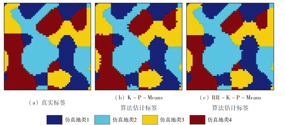
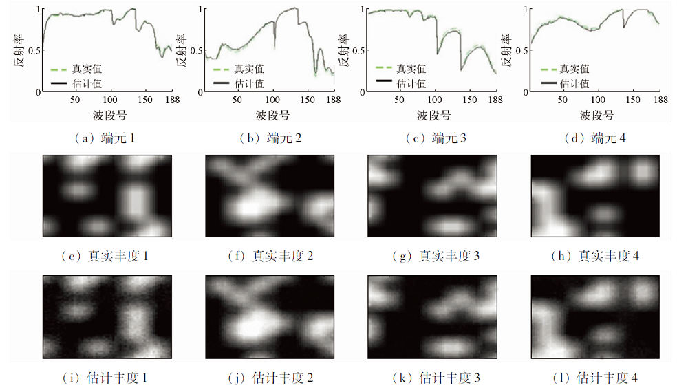
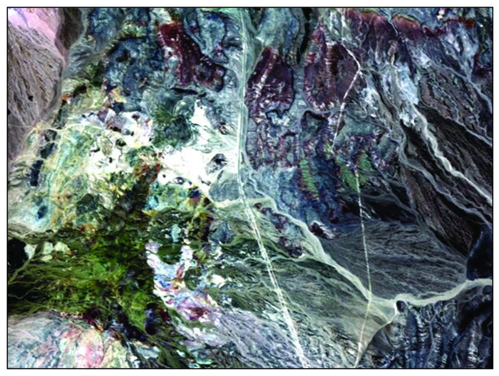
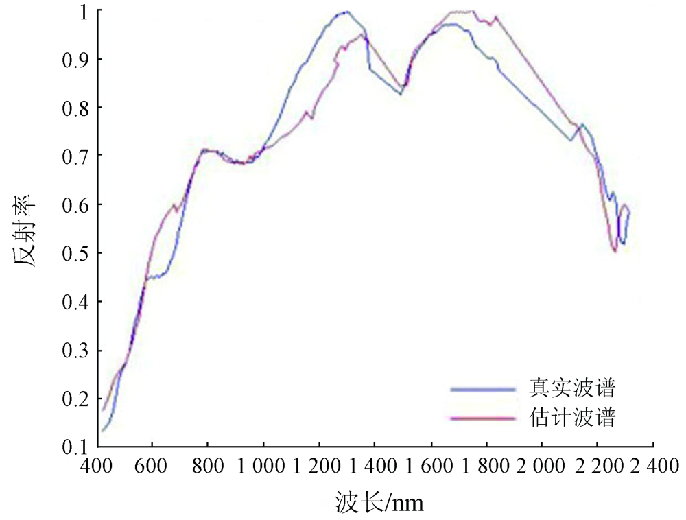
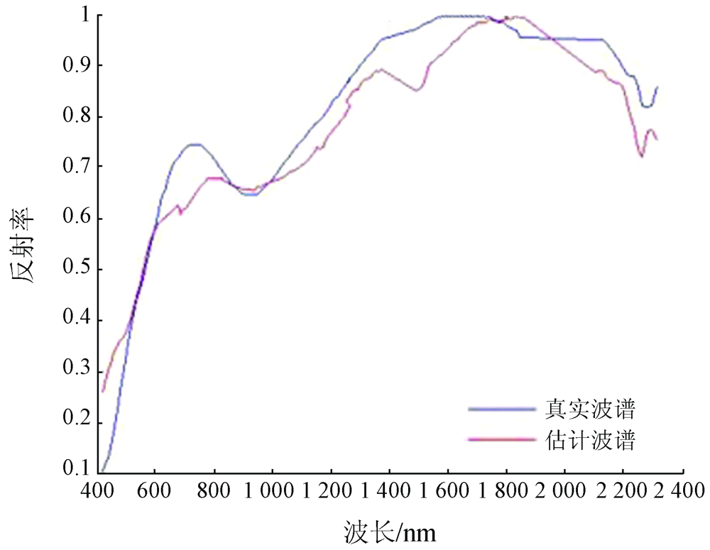
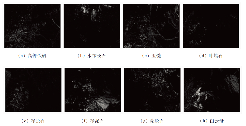
An effective unmixing method of hyperspectral mixed pixels can improve the precision of mineral information extraction. To further study such unmixing methods, this study explained the imaging mechanism of hyperspectral images using a linear spectral mixing model. The linear combinations of different mineral endmembers were used to express mixed pixels. The expected maximum (EM) algorithm was used to estimate the endmembers and abundance of mixed pixels under the framework of maximum likelihood estimation. A robust K-P-Means algorithm based on a random sampling consensus algorithm was proposed to improve the endmember optimization process, aiming to resist the impacts of anomalies on endmember extraction. The spectral angular distance and the spectral information divergence were used to assess the consistency between the estimated endmembers and the real endmembers. To obtain the similarity between the image and the original image, the structural similarity and the peak signal-to-noise ratio were used to measure the estimated abundance and endmembers. Various simulation data indicators show that the optimized model can obtain more precise estimations of endmembers and abundance. The mineral types were determined by matching the extracted endmembers with the mineral spectrum curves provided by the USGS spectral library. The actual data originated from the Cuprite data set of the AVIRIS hyperspectral sensor for the Nevada copper mining area. The results of mineral extraction showed that the model proposed in this study yielded satisfactory recognition results for eight types of main minerals including chlorite, which showed significant mineral aggregation and were consistent with the actual situation. Therefore, the method proposed in this study can extract precise mineral information while effectively resisting the impacts of noise.
孙肖, 徐林林, 王晓阳, 田野, 王伟, 张中跃. 基于优化K-P-Means解混方法的高光谱图像矿物识别[J]. 自然资源遥感, 2022, 34(3): 43-49.
SUN Xiao, XU Linlin, WANG Xiaoyang, TIAN Ye, WANG Wei, ZHANG Zhongyue. Mineral identification from hyperspectral images based on the optimized K-P-Means unmixing method. Remote Sensing for Natural Resources, 2022, 34(3): 43-49.
Li G J, Yang X S, Zhang X, et al. Application and analysis of ZY1-02D hyperspectral data in geological and mineral survey[J]. Remote Sensing for Land and Resources, 2021, 33(2):134-140.doi: 10.6046/gtzyyg.2020190.
doi: 10.6046/gtzyyg.2020190
Tian Q L, Pan W, Li Y, et al. Extraction of alteration information from hyperspectral core imaging based on wavelet packet transform and weight spectral angle mapper[J]. Remote Sensing for Land and Resources, 2019, 31(4):41-46.doi: 10.6046/gtzyyg.2019.04.06.
doi: 10.6046/gtzyyg.2019.04.06
Gan F P, Wang R S, Ma A N. Spectral identification tree(SIT) for mineral extraction based on spectral characteristics of minerals[J]. Earth Science Frontiers, 2003, 10(2):445-454.
Zhang C, Ye F W, Xu Q J, et al. Mineral mapping and analysis of alteration characteristics using airborne hyperspectral remote sensing data in the Baiyanghe uranium and beryllium ore district,Xinjiang[J]. Remote Sensing for Land and Resources, 2017, 29(2):160-166.doi: 10.6046/gtzyyg.2017.02.23.
doi: 10.6046/gtzyyg.2017.02.23
[6]
Chaudhry F, Wu C C, Liu W M, et al. Pixel purity index-based algorithms for endmember extraction from hyperspectral imagery[J]. Recent Advances in Hyperspectral Signal and Image Processing, 2006:29-62.
[7]
Winter M E. Comparison of approaches for determining endmembers in hyper-spectral data[C]// IEEE Aerospace Conference Proceedings.IEEE, 2000(3):305-313.
[8]
Nascimento J M P, Dias J M B. Vertex component analysis:A fast algorithm to unmix hyperspectral data[J]. IEEE Transactions on Geoscience and Remote Sensing, 2005, 43(2):898-910.
doi: 10.1109/TGRS.2005.844293
Wu B, Wang X Q, Zhang L P. Iterative abstraction of endmember based on total least square for mixture pixel decomposition[J]. Geomatics and Information Science of Wuhan University, 2008, 33(5):457-460.
[10]
Roberts D A, Gardner M, Church R, et al. Mapping chaparral in the Santa Monica Mountains using multiple endmember spectral mixture models[J]. Remote Sensing of Environment, 1998, 65(3):267-279.
doi: 10.1016/S0034-4257(98)00037-6
[11]
Asner G P, Lobell D B. A biogeophysical approach for automated SWIR unmixing of soils and vegetation[J]. Remote Sensing of Environment, 2000, 74(1):99-112.
doi: 10.1016/S0034-4257(00)00126-7
[12]
Song C. Spectral mixture analysis for subpixel vegetation fractions in the urban environment:How to incorporate endmember variability?[J]. Remote Sensing of Environment, 2005, 95(2):248-263.
doi: 10.1016/j.rse.2005.01.002
Lin H L, Zhang X, Sun Y L. Hyperspectral sparse unmixing of minerals with single scattering albedo[J]. Journal of Remote Sensing, 2016, 20(1):53-61.
[15]
Xu L L, Li J, Wong A, et al. K-P-Means:A clustering algorithm of K “Purified” Means for hyperspectral endmember estimation[J]. IEEE Geoscience and Remote Sensing Letters, 2014, 11(10):1787-1791.
doi: 10.1109/LGRS.2014.2309340
[16]
Fischler M A, Bolles R C. Random sample consensus:A paradigm for model fitting with applications to image analysis and automated cartography[J]. Communications of the ACM, 1981, 24(6):381-395.
doi: 10.1145/358669.358692
Wang R S, Yang S M, Yan B K. A review of mineral spectral identification methods and models with imaging spectrometer[J]. Remote Sensing for Land and Resources, 2007, 19(1):1-9.doi: 10.6046/gtzyyg.2007.01.01.
doi: 10.6046/gtzyyg.2007.01.01
[18]
Dempster A P, Laird N M, Rubin D B. Maximum likelihood from incomplete data via the EM algorithm[J]. Journal of the Royal Statistical Society(Series B), 1977, 39(1):1-38.
[19]
Lawson C L, Hanson R J. Solving least squares problems[M]. Englewood Cliffs: Prentice-Hall, 1974:161.
Guo J D, Xiang H. A robust method for estimating the fundamental matrix[J]. Computer Applications, 2005, 25(12):2845-2848.
[21]
Chang C I, Heinz D C. Constrained subpixel detection for remotely sensed images[J]. IEEE Transactions on Geoscience and Remote Sensing, 2000, 38(3):1144-1159.
doi: 10.1109/36.843007
[22]
Zhou W, Alan C B, Hamid R S, et al. Image quality assessment:From error visibility to structural similarity[J]. IEEE Transactions on Image Processing, 2004, 13(4):600-612.
pmid: 15376593
[23]
Huynh-Thu Q, Ghanbari M. Scope of validity of PSNR in image/video quality assessment[J]. Electronics Letters, 2008, 44(13):800-801.
doi: 10.1049/el:20080522
 2022, Vol. 34
  ), 徐林林2(