Quantifying the Urban Visual Perception of Chinese Traditional-Style Building with Street View Images

 ,
,  , ,
, ,
Abstract
:1. Introduction
2. Related Works
2.1. Urban Perception with Street View Images
2.2. Urban Perception with Deep Learning
3. Study Area and Dataset
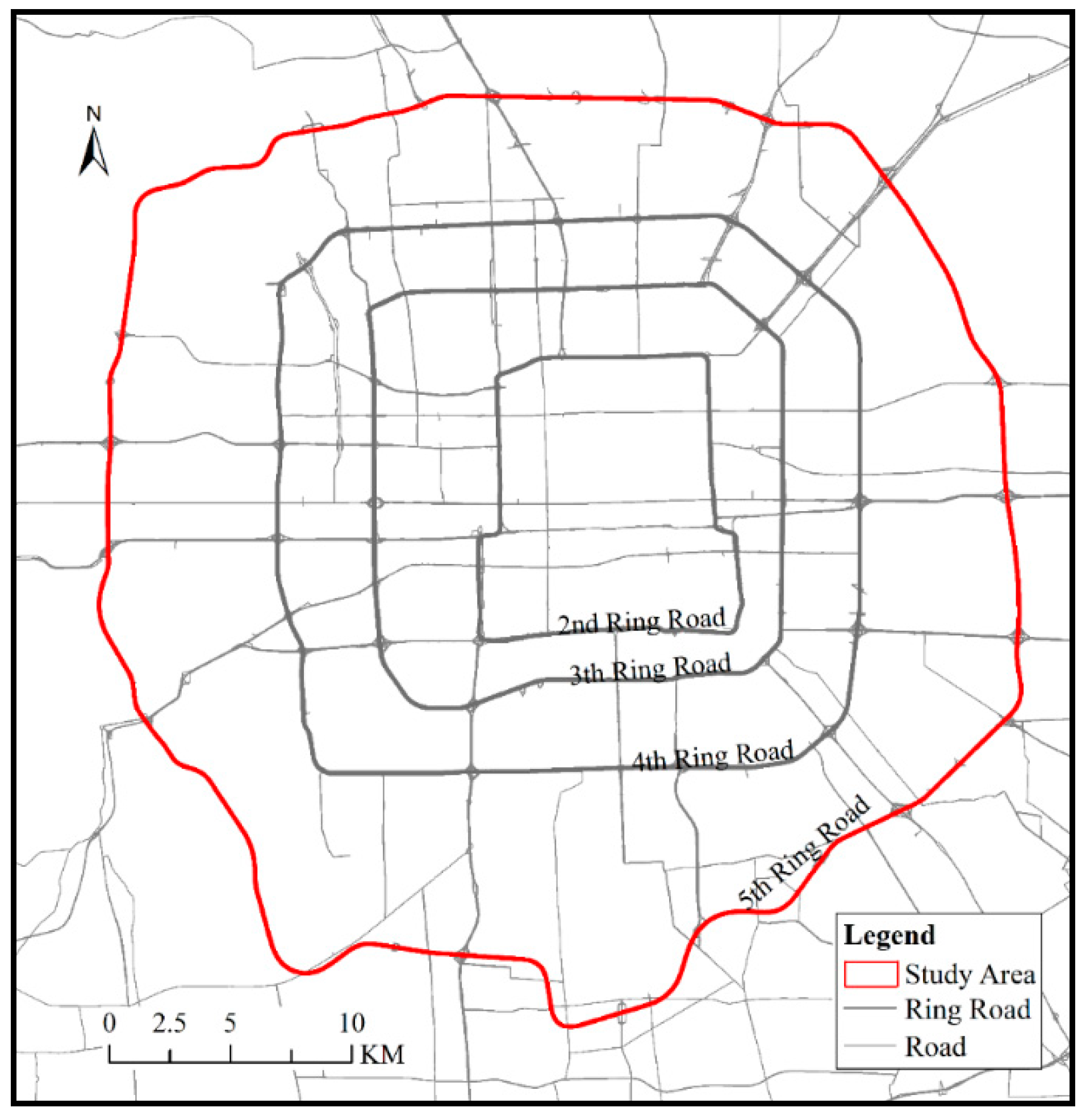
3.1. Study Area
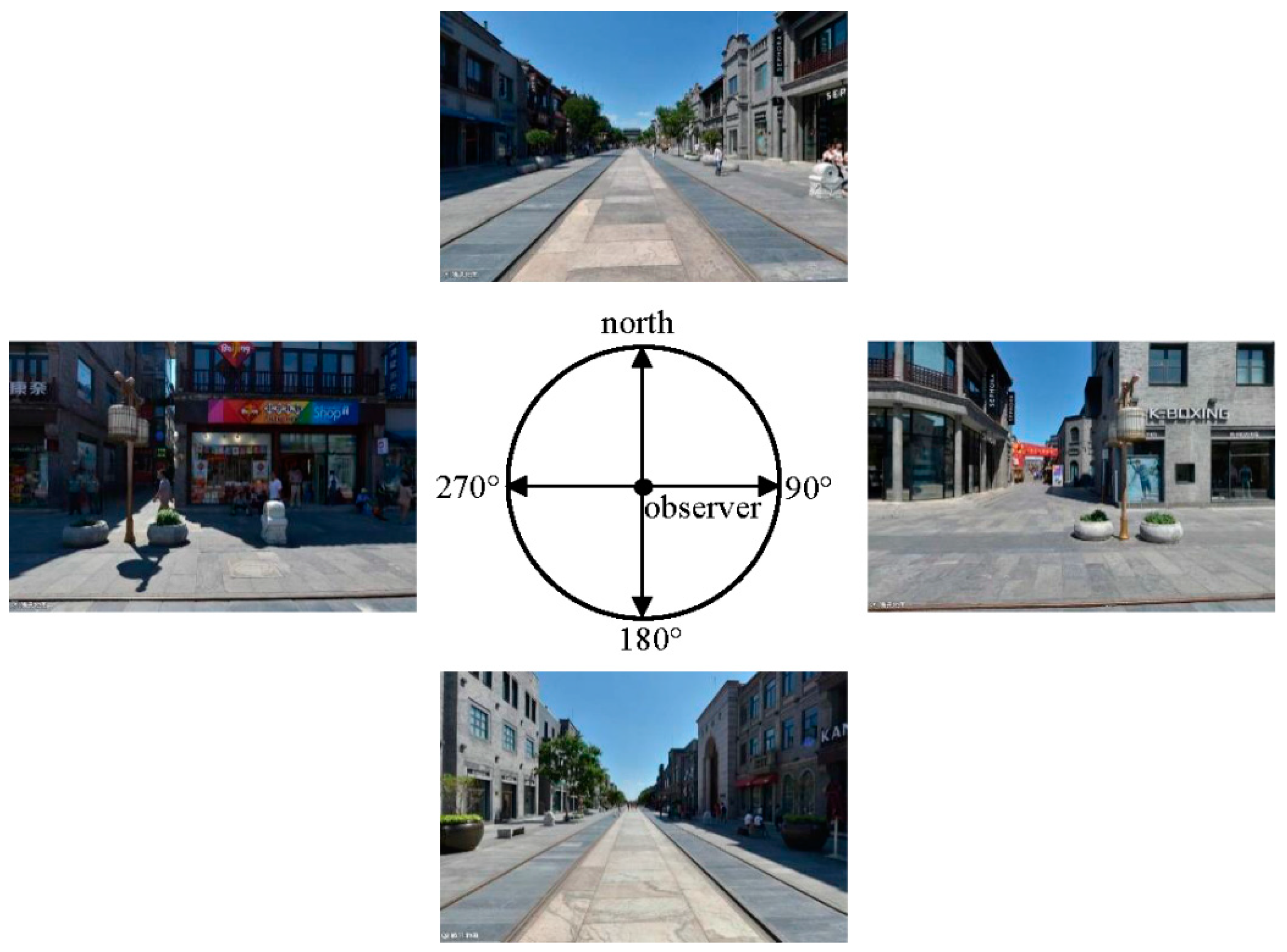
3.2. Data Acquisition
3.3. Categories of Chinese Traditional-Style Buildings
4. Methodology
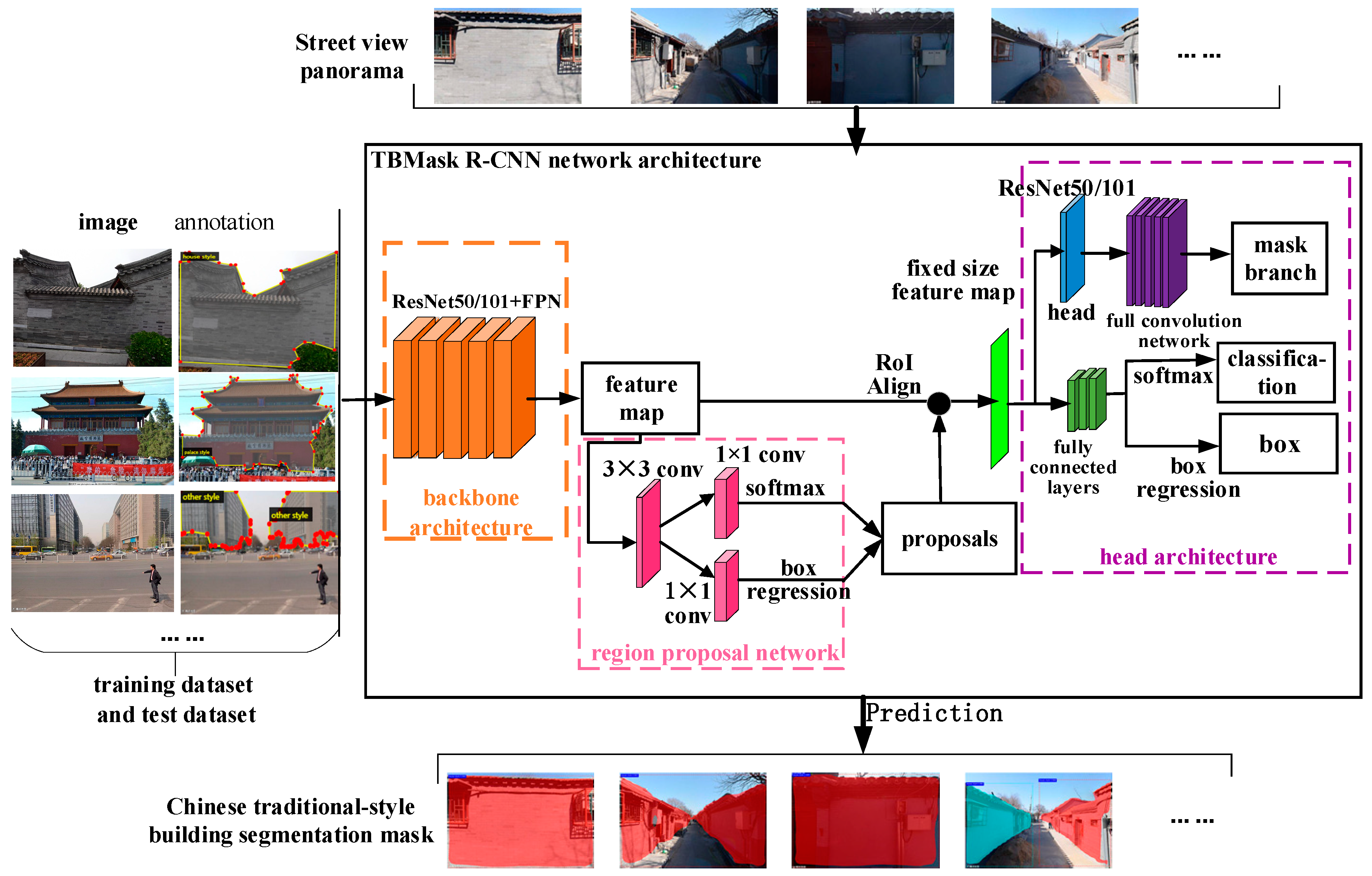
4.1. Deep Learning Network for Traditional-Style Building Segmentation
4.2. Traditional Building View Index
4.3. Moran’s I
5. Results
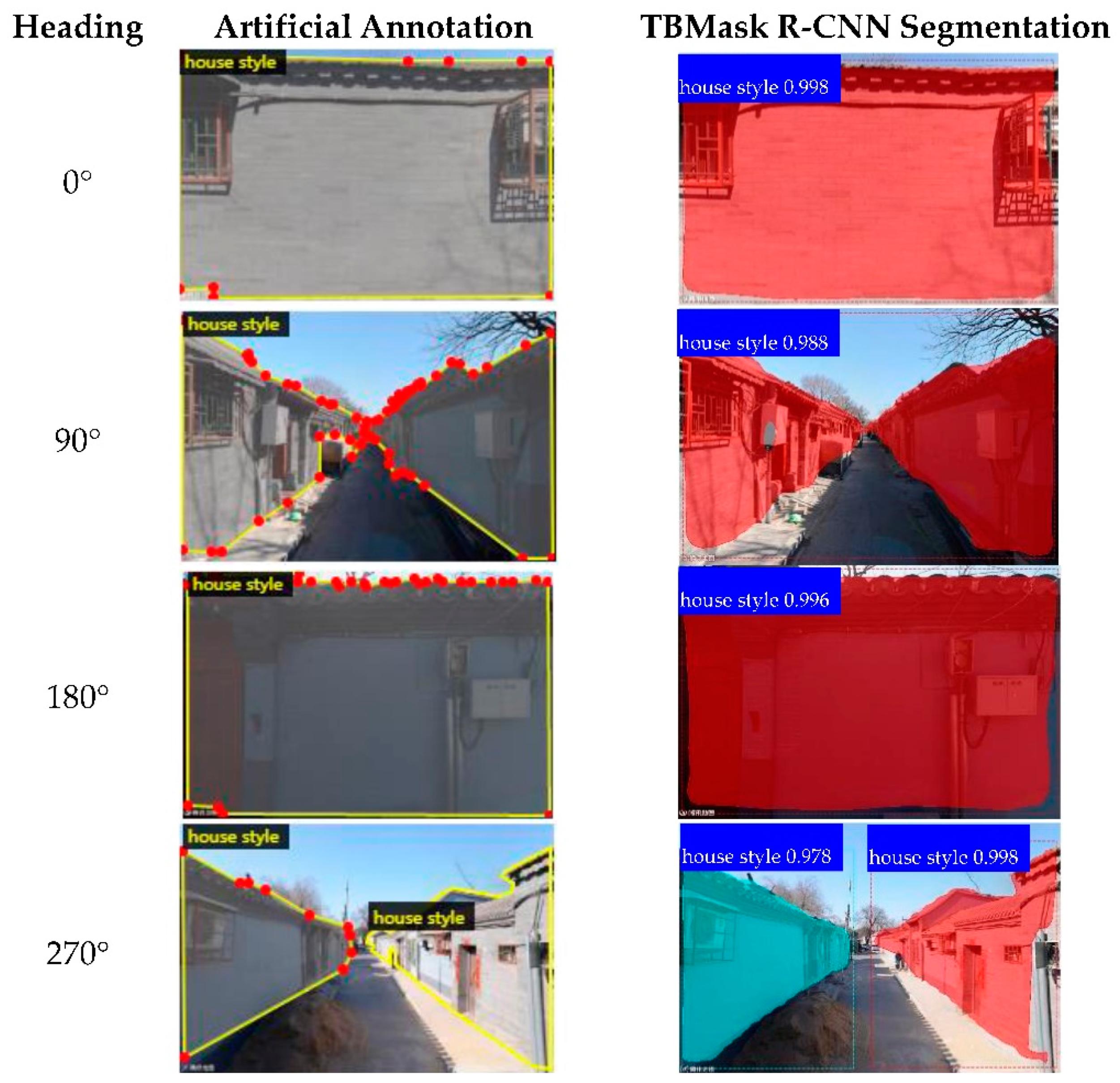
5.1. Accuracy of Building Segmentation
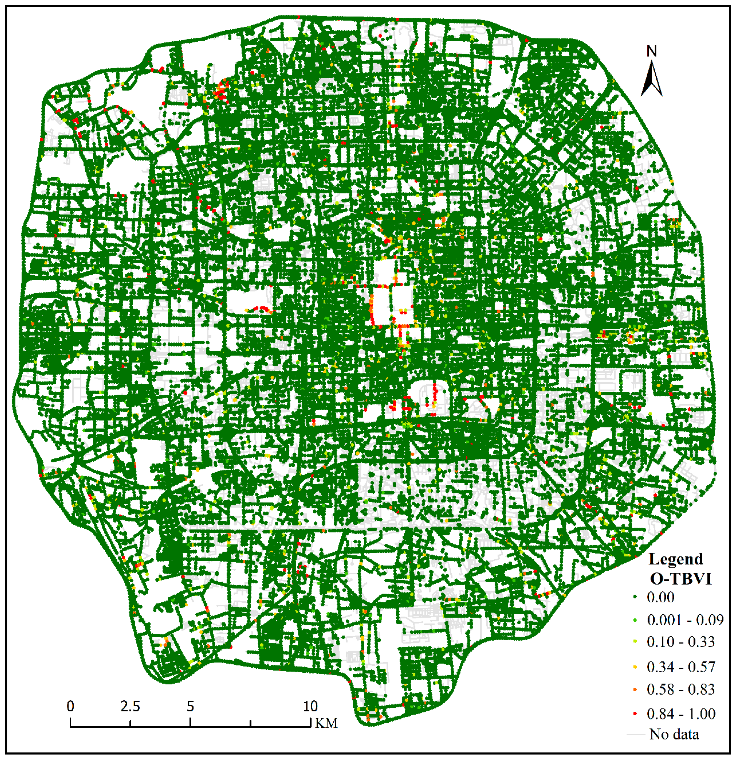
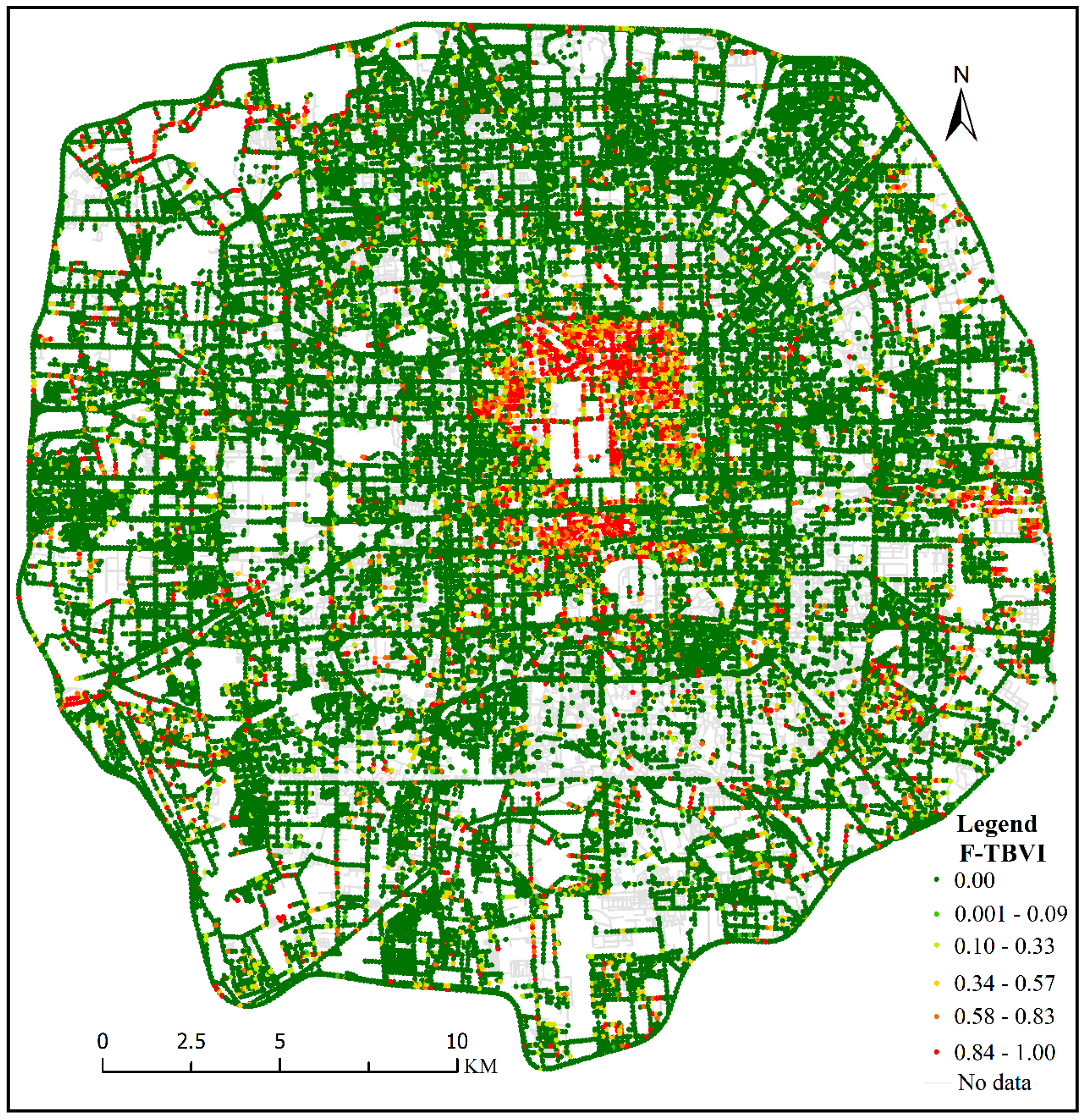
5.2. TBVI Results
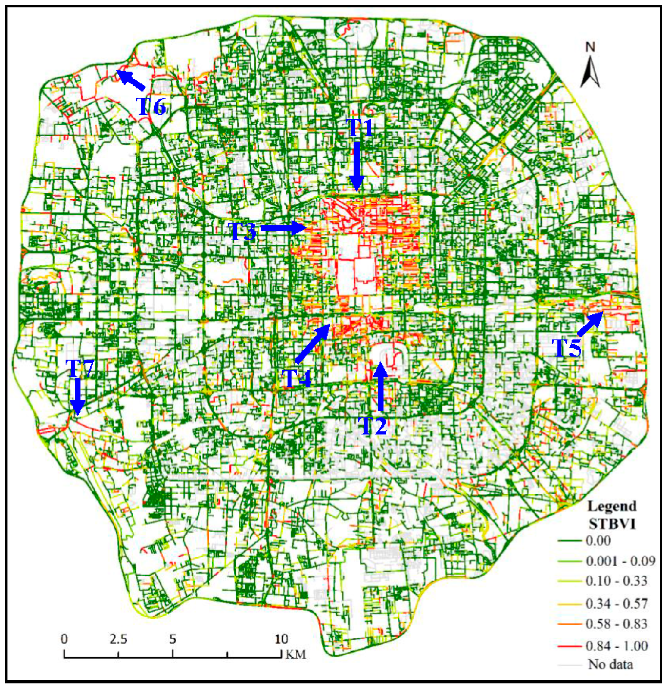
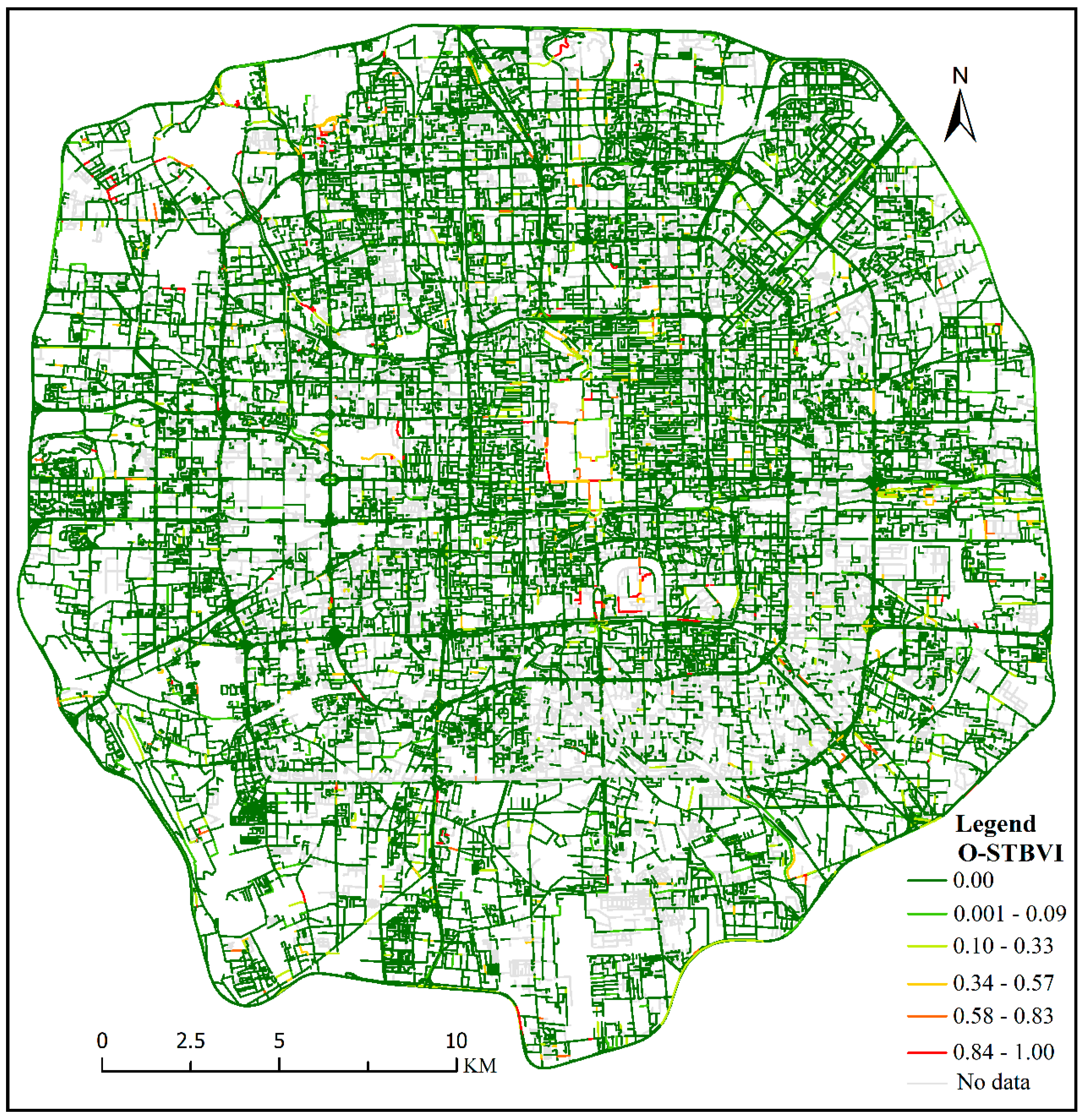
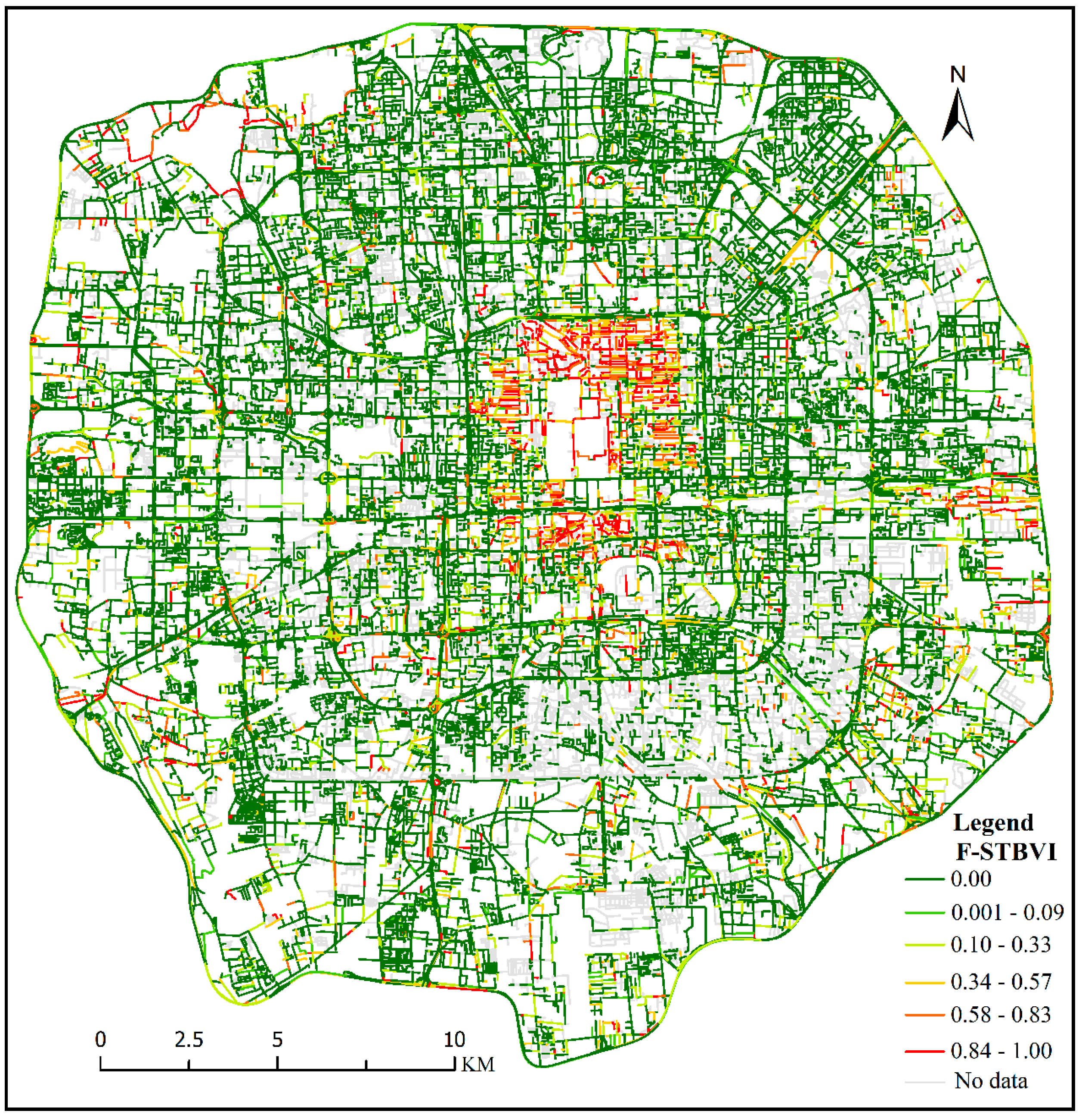
5.3. STBVI Results
6. Discussion and Conclusions
6.1. Discussion on TBVI
6.2. Discussion on STBVI
6.3. Conclusions
Author Contributions
Funding
Acknowledgments
Conflicts of Interest
References
- Dulinkeita, A.; Thind, H.; Affuso, O.; Baskin, M.L. The associations of perceived neighborhood disorder and physical activity with obesity among African American adolescents. BMC Public Health 2013, 13, 440. [Google Scholar] [CrossRef] [PubMed] [Green Version]
- Dubey, A.; Naik, N.; Parikh, D.; Raskar, R.; Hidalgo, C.A. Deep learning the city: Quantifying urban perception at a global scale. In Proceedings of the European Conference on Computer Vision, Amsterdam, The Netherlands, 8–16 October 2016; pp. 196–212. [Google Scholar]
- Porzi, L.; Rota Bulò, S.; Lepri, B.; Ricci, E. Predicting and understanding urban perception with convolutional neural networks. In Proceedings of the 23rd ACM International Conference on Multimedia, Brisbane, Australia, 26–30 October 2015; pp. 139–148. [Google Scholar]
- Naik, N.; Philipoom, J.; Raskar, R.; Hidalgo, C.A. Streetscore—Predicting the perceived safety of one million streetscapes. In Proceedings of the Computer Vision and Pattern Recognition, Las Vegas, NV, USA, 27–30 June 2016; pp. 793–799. [Google Scholar]
- Liu, L.; Silva, E.A.; Wu, C.; Wang, H. A machine learning-based method for the large-scale evaluation of the qualities of the urban environment. Comput. Environ. Urban Syst. 2017, 65, 113–125. [Google Scholar] [CrossRef]
- He, S.; Yoshimura, Y.; Helfer, J.; Hack, G.; Ratti, C.; Nagakura, T. Quantifying memories: Mapping urban perception. arXiv 2018, arXiv:1806.04054. [Google Scholar]
- Doersch, C.; Singh, S.; Gupta, A.; Sivic, J.; Efros, A.A. What makes Paris look like Paris. CACM 2015, 58, 103–110. [Google Scholar] [CrossRef]
- Lee, S.; Maisonneuve, N.; Crandall, D.; Efros, A.A.; Sivic, J. Linking past to present: Discovering style in two centuries of architecture. In Proceedings of the IEEE International Conference on Computational Photography, Houston, TX, USA, 24–26 April 2015; pp. 1–10. [Google Scholar]
- Seide, F.; Li, G.; Chen, X.; Yu, D. Feature engineering in Context-Dependent Deep Neural Networks for conversational speech transcription. In Proceedings of the Automatic Speech Recognition and Understanding, Waikoloa, HI, USA, 11–15 December 2011; pp. 24–29. [Google Scholar]
- Xu, Y.; Yang, Q.; Cui, C.; Shi, C.; Song, G.; Han, X.; Yin, Y. Visual urban perception with deep semantic-aware network. In Proceedings of the Conference on Multimedia Modeling, Thessaloniki, Greece, 8–19 January 2019; pp. 28–40. [Google Scholar]
- Anguelov, D.; Dulong, C.; Filip, D.; Frueh, C.; Lafon, S.; Lyon, R.; Ogale, A.; Vincent, L.; Weaver, J. Google street view: Capturing the world at street level. Computer 2010, 43, 32–38. [Google Scholar] [CrossRef]
- Cheng, L.; Chu, S.; Zong, W.; Li, S.; Wu, J.; Li, M. Use of tencent street view imagery for visual perception of streets. Int. J. Geo-Inf. 2017, 6, 265. [Google Scholar] [CrossRef]
- Hara, K.; Le, V.; Froehlich, J. Combining crowdsourcing and google street view to identify street-level accessibility problems. In Proceedings of the SIGCHI Conference on Human Factors in Computing Systems, Paris, France, 27 April–2 May 2013; pp. 631–640. [Google Scholar]
- Hwang, J.; Sampson, R.J. Divergent pathways of gentrification:racial inequality and the social order of renewal in Chicago neighborhoods. Am. Sociol. Rev. 2014, 79, 726–751. [Google Scholar] [CrossRef]
- Zhang, L.; Pei, T.; Chen, Y.; Song, C.; Liu, X. A Review of urban environmental assessment based on street view images. J. Geo-Inf. Sci. 2019, 21, 46–58. [Google Scholar] [CrossRef]
- Kelly, C.M.; Wilson, J.S.; Baker, E.A.; Miller, D.K.; Schootman, M. Using google street view to audit the built environment: Inter-rater reliability results. Ann. Behav. Med. 2013, 45, 108–112. [Google Scholar] [CrossRef] [Green Version]
- Rundle, A.G.; Bader, M.D.M.; Richards, C.A.; Neckerman, K.M.; Teitler, J.O. Using google street view to audit neighborhood environments. Am. J. Prev. Med. 2011, 40, 94–100. [Google Scholar] [CrossRef] [Green Version]
- Clarke, P.; Ailshire, J.; Melendez, R.; Bader, M.; Morenoff, J. Using google earth to conduct a neighborhood audit: Reliability of a virtual audit instrument. Health Place 2010, 16, 1224–1229. [Google Scholar] [CrossRef] [PubMed] [Green Version]
- Badland, H.M.; Opit, S.; Witten, K.; Kearns, R.A.; Mavoa, S. Can virtual streetscape audits reliably replace physical streetscape audits? J. Urban Health 2010, 87, 1007–1016. [Google Scholar] [CrossRef] [PubMed] [Green Version]
- Naik, N.; Kominers, S.D.; Raskar, R.; Glaeser, E.L.; Hidalgo, C.A. Computer vision uncovers predictors of physical urban change. Proc. Natl. Acad. Sci. USA 2017, 114, 7571–7576. [Google Scholar] [CrossRef] [PubMed] [Green Version]
- Dong, R.; Zhang, Y.; Zhao, J. How green are the streets within the sixth ring road of Beijing? An analysis based on tencent street view pictures and the green view index. Int. J. Environ. Res. Public Health 2018, 15, 1367. [Google Scholar] [CrossRef] [PubMed] [Green Version]
- Li, X.; Zhang, C.; Li, W.; Kuzovkina, Y.A.; Weiner, D. Who lives in greener neighborhoods? The distribution of street greenery and its association with residents’ socioeconomic conditions in Hartford, Connecticut, USA. Urban For. Urban Green. 2015, 14, 751–759. [Google Scholar] [CrossRef]
- Li, X.; Zhang, C.; Li, W.; Ricard, R.; Meng, Q.; Zhang, W. Assessing street-level urban greenery using Google Street View and a modified green view index. Urban For. Urban Green. 2015, 14, 675–685. [Google Scholar] [CrossRef]
- Li, X.; Zhang, C.; Li, W. Does the visibility of greenery increase perceived safety in urban areas? Evidence from the place pulse 1.0 dataset. ISPRS Int. Geo-Inf. 2015, 4, 1166–1183. [Google Scholar] [CrossRef] [Green Version]
- Li, H.; Páez, A.; Liu, D. Built environment and violent crime: An environmental audit approach using Google Street View. Comput. Environ. Urban Syst. 2017, 66, 83–95. [Google Scholar]
- Liang, J.; Gong, J.; Sun, J.; Zhou, J.; Li, W.; Li, Y.; Liu, J.; Shen, S. Automatic sky view factor estimation from street view photographs—A big data approach. Remote Sens. 2017, 9, 411. [Google Scholar] [CrossRef] [Green Version]
- Dalal, N.; Triggs, B. Histograms of oriented gradients for human detection. In Proceedings of the 2005 IEEE Computer Society Conference on Computer Vision and Pattern Recognition, San Diego, CA, USA, 20–25 June 2005; pp. 886–893. [Google Scholar]
- Lowe, D.G. Distintive image features from scale-invariant keypoints. Int. J. Comput. Vis. 2004, 60, 91–110. [Google Scholar] [CrossRef]
- Krizhevsky, A.; Sutskever, I.; Hinton, G.E. Imagenet classification with deep convolutional neural networks. In Proceedings of the Advances in Neural Information Processing Systems, Lake Tahoe, NV, USA, 3–6 December 2012; pp. 1097–1105. [Google Scholar]
- Donahue, J.; Jia, Y.; Vinyals, O.; Hoffman, J.; Zhang, N.; Tzeng, E.; Darrell, T. Decaf: A deep convolutional activation feature for generic visual recognition. In Proceedings of the International Conference on Machine Learning, Beijing, China, 21–26 June 2014; pp. 647–655. [Google Scholar]
- Seresinhe, C.I.; Preis, T.; Moat, H.S. Using deep learning to quantify the beauty of outdoor places. R. Soc. Open Sci. 2017, 4, 170170. [Google Scholar] [CrossRef] [Green Version]
- Shen, Q.; Zeng, W.; Ye, Y.; Arisona, S.M.; Schubiger, S.; Burkhard, R.; Qu, H. StreetVizor: Visual exploration of human-scale urban forms based on street views. IEEE Trans. Vis. Comput. Graph. 2018, 24, 1004–1013. [Google Scholar] [CrossRef] [PubMed]
- Trends and Characteristics of Population Change in Beijing in 2014. Available online: http://tjj.beijing.gov.cn/tjsj/zxdcsj/rkcydc/dcsj_4597/201601/t20160128_171191.html (accessed on 6 July 2019).
- Tencent Street View (TSV) API. Available online: https://lbs.qq.com/panostatic_v1/guide-getImage.html (accessed on 10 August 2018).
- Li, S. The Arts of China; Inner Mongolia People’s Publishing House: Hohhot, China, 2006. [Google Scholar]
- Liu, S. Construction Civilization—Chinese Traditional Culture and Traditional Architecture; Tsinghua University Press: Beijing, China, 2014. [Google Scholar]
- Cao, X. The Research on Urban Color of Historic Sites in the Old City of Beijing. Master’s Thesis, Beijing University of Civil Engineering and Architecture, Beijing, China, 2012. [Google Scholar]
- Dutta, A.; Gupta, A.; Zissermann, A. Image Annotator. Available online: http://www.robots.ox.ac.uk/~vgg/software/via (accessed on 20 August 2018).
- He, K.; Gkioxari, G.; Dollár, P.; Girshick, R. Mask R-CNN. In Proceedings of the 2017 IEEE International Conference on Computer Vision (ICCV), Venice, Italy, 22–29 October 2017; pp. 2980–2988. [Google Scholar]
- Yang, J.; Zhao, L.; Mcbride, J.; Gong, P. Can you see green? Assessing the visibility of urban forests in cities. Landsc. Urban. Plan. 2009, 91, 97–104. [Google Scholar] [CrossRef]
- Dubin, R.A. Spatial autocorrelation: A primer. J. Hous. Econ. 1998, 7, 304–327. [Google Scholar] [CrossRef]
- Kelejian, H.H.; Prucha, I.R. On the asymptotic distribution of the Moran I test statistic with applications. J. Econom. 2001, 104, 219–257. [Google Scholar] [CrossRef] [Green Version]
- Liu, L. Study on the Protection of District Protectde Historical Sites in Beijing Old City. Master’s Thesis, Beijing University of Civil Engineering and Architecture, Beijing, China, 2018. [Google Scholar]
- Ping-Fang, X.U. The Planning and preservation of the streets in the old city of Beijing. J. Beijing Union Univ. 2008, 6, 23–27. [Google Scholar]
- Yao, T.; Yang, X. A Comparative study on the street space form in the old city of Beijing: A case study of Shijia Hutong, the White Stupa Temple area, and dashilanr. J. Landsc. Res. 2018, 10, 22–26. [Google Scholar]
- Whitehand, J.; Gu, K. Urban conservation in China: Historical development, current practice and morphological approach. Town Plan. Rev. 2007, 78, 643–670. [Google Scholar] [CrossRef]
- Beijing Urban Master Plan (2016–2035). Available online: http://ghzrzyw.beijing.gov.cn/zhengwuxinxi/zxzt/bjcsztgh20162035/202001/t20200102_1554606.html (accessed on 20 May 2018).
- Lambiotte, R.; Blondel, V.D.; Kerchove, C.D.; Huens, E.; Prieur, C.; Smoreda, Z.; Dooren, P.V. Geographical dispersal of mobile communication networks. Phys. A Stat. Mech. Its Appl. 2008, 387, 5317–5325. [Google Scholar] [CrossRef]
- Wang, M.H.; Schrock, S.D.; Broek, N.V.; Mulinazzi, T. Estimating dynamic origin-destination data and travel demand using cell phone network data. Int. J. ITS Res. 2013, 11, 76–86. [Google Scholar] [CrossRef]


| Category | Features | Representative Buildings |
|---|---|---|
| Official style | The building has a grand scale, luxurious and elegant style, with glazed tiles, red columns, and colored paintings. The color of the building is mainly red, yellow, green, and blue. |  |
| Folk style | The shape of building is simple, and the materials are blue brick, gray tile, and stone. The color of the building is mainly blue-gray and gray-white. |  |
| Non-traditional-style | Simple, plain, geometric forms, rectangular shapes, linear elements, and a rejection of ornament, particularly the use of glass, steel and reinforced concrete. |  |
| Categories of Building Style | Categories of Datasets | ||
|---|---|---|---|
| Training | Validation | Test | |
| Official-style | 1148 | 143 | 143 |
| Folk-style | 1150 | 144 | 144 |
| Non-traditional-style | 1150 | 144 | 144 |
| Total | 3448 | 431 | 431 |
| Abbreviation | Full Name |
|---|---|
| TSV | Tencent Street View |
| TBMask R-CNN | Traditional Building Mask Region-based Convolutional Neural Networks |
| TBVI | Traditional Building View Index |
| STBVI | Street of Traditional Building View Index |
| RPN | Region proposal network |
| ResNet | Residual network |
| ROI | Region of interest |
| AP | Average precision |
| MAP | Mean average precision |
| O-TBVI | The TBVI of official-style buildings |
| F-TBVI | The TBVI of the folk-style buildings |
| O-STBVI | The STBVI of official-style buildings |
| F-STBVI | The STBVI of the folk-style buildings |
| Strategy | Building Style | AP | MAP |
|---|---|---|---|
| Strategy 1 | Official style | 0.53 | 0.54 |
| Folk-style | 0.55 | ||
| Non-traditional-style | 0.54 | ||
| Strategy 2 | Official style | 0.78 | 0.80 |
| Folk-style | 0.81 | ||
| Non-traditional-style | 0.82 |
| Area | TBVI | O-TBVI | F-TBVI |
|---|---|---|---|
| Within Second Ring Road | 0.47 | 0.17 | 0.45 |
| Between Second and Third Ring Roads | 0.13 | 0.14 | 0.11 |
| Between Third and Fourth Ring Roads | 0.033 | 0.026 | 0.029 |
| Between Fourth and Fifth Ring Roads | 0.145 | 0.094 | 0.129 |
| Total | 0.27 | 0.09 | 0.28 |
| Area | Chinese Traditional-Style | Subclass 1: Official-Style | Subclass 2: Folk-Style | |||
|---|---|---|---|---|---|---|
| STBVI Mean | Percentage (%) | STBVI Mean | Percentage (%) | STBVI Mean | Percentage (%) | |
| Within Second Ring Road | 0.365 | 31.76 | 0.018 | 7.69 | 0.347 | 30.19 |
| Between Second and Third Ring Roads | 0.055 | 14.40 | 0.005 | 3.18 | 0.050 | 12.70 |
| Between Third and Fourth Ringing Roads | 0.052 | 13.81 | 0.006 | 3.77 | 0.047 | 11.79 |
| Between Fourth and Fifth Ring Roads | 0.076 | 17.11 | 0.009 | 5.16 | 0.067 | 14.78 |
© 2020 by the authors. Licensee MDPI, Basel, Switzerland. This article is an open access article distributed under the terms and conditions of the Creative Commons Attribution (CC BY) license (http://creativecommons.org/licenses/by/4.0/).
Share and Cite
Zhang, L.; Pei, T.; Wang, X.; Wu, M.; Song, C.; Guo, S.; Chen, Y. Quantifying the Urban Visual Perception of Chinese Traditional-Style Building with Street View Images. Appl. Sci. 2020, 10, 5963. https://0-doi-org.brum.beds.ac.uk/10.3390/app10175963
Zhang L, Pei T, Wang X, Wu M, Song C, Guo S, Chen Y. Quantifying the Urban Visual Perception of Chinese Traditional-Style Building with Street View Images. Applied Sciences. 2020; 10(17):5963. https://0-doi-org.brum.beds.ac.uk/10.3390/app10175963
Chicago/Turabian StyleZhang, Liying, Tao Pei, Xi Wang, Mingbo Wu, Ci Song, Sihui Guo, and Yijin Chen. 2020. "Quantifying the Urban Visual Perception of Chinese Traditional-Style Building with Street View Images" Applied Sciences 10, no. 17: 5963. https://0-doi-org.brum.beds.ac.uk/10.3390/app10175963