A Critical Review of Flood Risk Management and the Selection of Suitable Measures


1
College of Engineering & Science, Victoria University, Melbourne, VIC 8001, Australia
2
Department of Civil Engineering, International Islamic University, Islamabad 44000, Pakistan
3
Department of Civil Engineering, Lakehead University, Thunder Bay, ON P7B 5E1, Canada
4
Water Resources Management Section, Faculty of Civil Engineering and Geosciences, Delft University of Technology, 2600 GA Delft, The Netherlands
*
Authors to whom correspondence should be addressed.
Appl. Sci. 2020, 10(23), 8752; https://0-doi-org.brum.beds.ac.uk/10.3390/app10238752
Submission received: 23 November 2020
/
Revised: 5 December 2020
/
Accepted: 5 December 2020
/
Published: 7 December 2020
(This article belongs to the Special Issue CITIES: Energetic Efficiency, Sustainability; Infrastructures, Energy and the Environment; Mobility and IoT; Governance and Citizenship)
Abstract
:Modern-day flood management has evolved into a variety of flood management alternatives. The selection of appropriate flood measures is crucial under a variety of flood management practices, approaches, and assessment criteria. Many leading countries appraise the significance of risk-based flood management, but the fixed return period is still the de facto standard of flood management practices. Several measures, approaches, and design criteria have been developed over time. Understanding their role, significance, and correlation toward risk-based flood management is crucial for integrating them into a plan for a floodplain. The direct impacts of a flood are caused by direct contact with the flood, while indirect impacts occur as a result of the interruptions and disruptions of the socio-economical aspects. To proceed with a risk-based flood management approach, the fundamental requirement is to understand the risk dynamics of a floodplain and to identify the principal parameter that should primarily be addressed so as to reduce the risk. Risk is a potential loss that may arise from a hazard. On the one hand, exposure and susceptibility of the vulnerable system, and on the other, the intensity and probability of the hazard, are the parameters that can be used to quantitatively determine risk. The selection of suitable measures for a flood management scheme requires a firm apprehension of the risk mechanism. Under socio-economic and environmental constraints, several measures can be employed at the catchments, channels, and floodplains. The effectiveness of flood measures depends on the floodplain characteristics and supporting measures.
1. Introduction
Floods can be devastating, and they are frequently compared to all other natural disasters worldwide, because they have the highest number of casualties and the highest economic losses. The worldwide average direct annual cost of natural disasters between 2000 and 2012 was roughly $100 billion [1]. The following facts are presented based on flood-associated studies [2]. One-third of natural catastrophes can be considered to be floods, one of every ten fatalities due to natural disasters are flood-related, and flooding is responsible for one-third of overall economic loss ($250 billion worldwide over the last fifteen years alone). A stark 95–97% of fatalities from natural disasters are caused by floods in developing countries. At the same time, 90% of natural disasters include flooding, causing a $6 billion annual loss in the world economy. The impact of floods can vary throughout the world due to geographical, agricultural, and economic reasons. The Nile, the Mekong, and the lower Indus flood plains are used for regular agricultural needs, while the risk of floods is largely overlooked by the growing population and industrial activities of both developed and developing countries [3,4]. However, some research studies support the severity of floods, and in recent years, the frequency of floods has increased [5]. Flood situations tend to worsen with climate change, land subsidence, urbanization, and population growth.
The problem and its solutions are nothing new, but the demand for further efficient and effective flood management is quite obvious with the ever-growing environmental awareness, higher living standards, and technological expertise. Moreover, management of floods is an obtuse, complex phenomena that should be periodically revised roughly every 30–50 years [6]. A variety of new strategies, concepts, and initiatives have consequently been proposed, namely: flood protection, evacuation, environmentally-friendly solutions, the denaturalization of rivers, foolproof structural measures, non-structural measures, soft measures, hard measures, room for the river, flood fighting, resilient approach, sustainable flood management, integrated approach, risk-based flood management, living with floods, nature-based solutions, economical solutions, spatial planning modifications, flood risk zoning, coping with floods, floodplain restoration, non-adverse impact approaches, catchment management, community cooperation, compensation, dykes, floodwalls, warning system, encroachment control, flood insurance, floodproofing, flow diversion, groundwater recharge, public awareness, relief efforts, river improvement, storage and retention, and sustainable drainage systems, just to name a few.
1.1. Research Question
In the presence of numerous flood management approaches, measures, criteria, plans, and strategies, it is difficult to choose the most appropriate flood management practice; however, choosing the most efficient and appropriate strategies is the most critical step toward flood management. With the increasing number of new concepts and terminologies, the following main concern arises:
How can an effective and efficient flood management practice be developed under the prevailing conditions of a floodplain?
The following sub-questions are formulated to build the investigation structure of the main research question:
- How can an appropriate measure/scheme of measures for flood management be chosen?
- What are the basic elements of flood management?
- What is the role of different measures in flood risk reduction?
- What is risk-based flood management, and where does it stand when there are so many modern concepts, theories, approaches, and strategies?
- Among so many understandings and definitions of risk, which one is best, and why should it be considered for flood management?
- How can different flood management measures and approaches be compared while they have different targets and different outcomes?
- Is a detailed assessment of all possible combinations of measures required in order to design a more effective scheme for a floodplain?
The research presented through this manuscript addresses the basic questions that decision-makers have while choosing flood management measures. Furthermore, fundamental principles of flood management have also been identified in order to clarify essential theories, techniques, and solutions for flood prevention. Herein, specific guidelines are discussed for an optimal flood management approach.
1.2. Limitations and Scope
This research paper covers the development of a general framework for flood management options. The implementation strategies, technical designs, cost–benefits analysis, and discussions on possible flood management options are beyond the scope of this research. Several types of floods exist, such as pluvial, fluvial, urban, flash, tidal, and dam breaks. However, for this research, only fluvial flood is considered for the formation of a decision supporting system in managing floods. The research strongly recommends considering the environmental and social effects of flood management aspects, and assumes that intangibles related to these two aspects are converted into tangibles for risk evaluation. However, the negative environmental impacts of the structural measures are not considered while shortlisting the preferred flood management options.
2. Flood Management Practices
Risk-based flood management is in the initial evolving stages. The comprehension, practices, and criteria are maturing, with slight variations around the globe. Despite differences in the formation of strategies, the rules and obligations involved with stormwater maps are often varied around the globe. From region to region, procedural information and mapping methods often differ, mainly because of local knowledge and problems. Thus, in several countries, flood maps but with different features have been developed.
2.1. Worldwide Practices
In the USA, the Federal Emergency Management Agency (FEMA) identifies flood hazard areas, maps flood hazard areas, sets flood insurance rates, covers the risk, establishes design requirements for floodplain development, and provides funding for mitigation projects [7]. The 1/100-year flood is the de facto flood risk management norm in the USA. Local governments prohibit construction in a floodway of a 1/100-year flood zone. In addition, the ground floor of new or significantly renovated buildings in a 1/100-year flood zone must be elevated if a levee is not provided. Similarly, for both river and sea flooding, flood maps are developed in the U.K. “River or sea flooding was mapped for 1 percent and 0.5 percent probability floods, respectively, not considering defenses because if an extreme event flood occurs, defenses can be overtopped or fail” [8]. The Netherlands has a long history of flood management. At the moment, about 55% of the Netherlands’ total surface area is vulnerable to flooding, and about 25% is below the mean sea level [9]. The country follows different standards, including the highest safety standard (1/10,000-year flood) [10]. At the same time, Germany’s Parliament adopted the “Flood Control Act” in July 2004 as a consequence of severe flood damage in August 2002; however, no formal and uniform nomenclature or accepted flood management practices are available [11]. Flood safety standards along the coast are based on a 100-year flood return period. Flood protection safety standards along the main courses of the river differ greatly, and range from 1/30 years to 1/1000 years along the upper Rhine [12]. Approximately one-fourth of the total French population is exposed to floods [13]. In France, only one return period is calculated for flood hazard [10]. The Federal Flood Commission (FFC) is responsible for all flood-related issues in Pakistan [14]. A 1/100-year flood is a widely accepted design standard of flood protection measures. However, flood management is dominated by political influence.
2.2. Measures, Approaches, and Practices
The most crucial step for flood management is to select effective and suitable measures, such as direct measures (flood abatement, flood control, and flood alleviation) and indirect measures, both structural and non-structural. Flood control activities can conventionally be categorized as recovery measures, flood alleviation, flood control, and flood relief. These activities include structural and non-structural approaches, or contribute to the reduction of floodplain activity. The risk-based assessment even impacts measures and approaches of flood management. A conceptual correlation between the different measures, plans/projects, design criteria, and approaches are depicted in Figure 1. This section discusses the role of these components and illustrates the significance of implementing practices related to risk-based management of floods.
2.2.1. Measures
Understanding the role of numerous measures is a requirement for designing an efficient approach. Flood measures can broadly be divided into three classes, namely: thwarting flood peak formation (flood abatement), regulating the inundation (flood control), and reducing adverse effects (flood alleviation) [15]. When selecting a flood management measure, it is important to consider what the targeted risk parameter is. Table 1 describes the various flood management options/measures related to target risk factors. Understanding the role of a selected flood management measure in reducing risk by reducing one or more components of risk helps facilitate choosing an appropriate flood management option under site constraints. The constraints could be economic, social, topographical, or environmental.
Often, it is crucial to verify that measures include some structural activity that may alter a river’s flow. Non-structural measures to control floods involve practices to mitigate or alleviate damage caused by floods without constructing a flow-changing infrastructure [16]. Although non-structural measures were initially suggested as part of an integrated floodplain management plan [17], the non-structural possibilities were also presented as an alternative to conventional engineering solutions.
Some practices limit risk by decreasing the chance and/or magnitude, although other measures aim to decrease susceptibility and/or damage by reducing vulnerability. Focusing on the mechanism of risk, measures are being divided into two main categories—direct and indirect measures. It is necessary to remember which criteria a flood control measure aims at during the selection of a measure. The adoption of structural measures and risk mechanics together with the target risk parameters is critical for achieving desired outcomes in the consideration of flood management solutions based on classification. Considering flood management options based on classification, the involvement of structural measures and risk mechanics, along with the target risk parameters, is important in order to obtain desirable results.
Some measures strive to improve society’s ability to rebuild after floods. Examples include flood insurance, rehabilitation, reimbursement, and voluntary assistance, which can be categorized as recovery/indirect intervention, as they do not explicitly mitigate losses [18]. Relief efforts do less to mitigate potential casualties in floods [19], and likewise, the damage can also be raised by compensating.
2.2.2. Approaches
An approach or strategy is comprised of motivations and primacies that aim to select the most suitable measures. Depending on the specific economic, environmental, social, hydrological, and geological conditions, the most appropriate approach will vary accordingly [19].
The risk-based strategy not only enables analyzing and designing a measure, but also identifies the most suitable strategy in terms of the effectiveness of flood management according to the local demands. Flood management approaches, based on flooding risk mechanics, may be classified into two groups. Direct approaches strive to reduce the losses, while indirect approaches tend to recover from these losses rapidly. Direct approaches can be further distinguished in relation to those measures that minimize the vulnerability of floodplain inhabitants with those that minimize hazards [20].
- Direct approaches
- ○
- Hazard-focused
- ○
- Vulnerability-focused
- Indirect approaches
- ○
- Resilience-based
The approaches for hazard management are based on theory “to keep floods away from people”. Important examples are flood management and flood mitigation. The approach itself seeks to minimize floods by adopting structural measures. These strategic measures must be comprehensive and manage to reduce the flood occurrence events’ probability if installed at upper catchments. Such measures may otherwise be locally applied to minimize the magnitude with which a flood affects an area [21].
The “lives with floods” theory has been adopted as an adapted indicator of risk management [22]. The components of preparedness (event-based response) and adaptation (societal adjustment) [22] minimize susceptibility. Annual flood events are anticipated and expected in highly adapted societies, while such severe events may still lead to losses and destruction [20]. Flood zoning restricts vulnerability by minimizing both susceptibility (flood proofing) and exposure (encroachment control) [23]. Encroachment control is another option based on the concept of “restraining people from the flood” by limiting exposure within a floodplain.
Examples of indirect measures include rehabilitation, compensation, flood insurance, and relief. In general, resilience-based flood management is related to indirect approaches. The persisting philosophy is “accept floods and recover afterward”, while K.M. de Bruijn and Beek [24] define resilience as “the ability of a system to return to its equilibrium after a reaction to a disturbance”. In order to support swift rescue after a flood subsides, a resilient mechanism needs to be developed. Indirect approaches substantially decrease indirect losses and impact direct damage indirectly.
Other concepts exist in addition to the above-stated approaches, like “integrated flood management”, “no adverse impact approach”, “floodplain restoration”, “sustainable flood management”, and so on. These options are exclusive in nature and may be selected along with other methods. Integrated flood management, for instance, avoids discrete perspectives for flood control measures [25] and does not exclude or limit a particular measure. In general, the integration of approaches and methods will bring about the most appropriate management strategy [20], and also involves complementary options [26].
2.2.3. Design Criteria
Developing an effective strategy is necessary for the enhanced effectiveness of various measures to reduce hazards (by reducing the probability and/or intensity of floods) or vulnerability (by reducing susceptibility or exposure) by adjusting one or more risk parameters. The measures are selected and designed in order to achieve the desired results within economic, social, and environmental limitations. Evaluation criteria need to be object-oriented, transparent, and clear, including economic, social appraisal, and environmental evaluation due to non-structural and structural technical requirements. Risk-based assessment methods were introduced during the 1990s in the area of flood management, and provide a clear focus on flood impacts by reducing all possible flood-related risks [16].
2.2.4. Plans and Schemes
The severity of a flood issue and the availability of resources dictates the allocation of resources for projects. A risk-based assessment enables policymakers to focus on the outcome, thus resulting in choosing a set of the most suitable flood management measures. Risk-based analysis aids in assessing and designing measures, as well as choosing an appropriate flood management strategy. Risk-based management is designed to evaluate the projects for minimizing, but not exactly eliminating, flood risk [27].
The primary goal of all of the standards that have so far been established is weighing the benefits and costs of the measures [28]. For a risk-based design, all of the possible damages due to floods are converted into tangible losses and evaluated through cost–benefit analysis in order to achieve the maximum efficiency of the flood management approach.
Small business loss is considered in small scale studies because, owing to financial transfers, such damage may not be severe at a regional level. Production in the area may be taken over by non-flooded firms, which will not cause any production losses at this stage. Loss to individual families, companies, or manufacturing plants is referred to as “financial injury”, while the macroeconomic consequences are referred to as “economic damage” for a region or country [24].
3. Risk-Based Flood Management
“Flood management” refers to the general method involved in flood prevention and subsequent flood loss [16], whereas “risk-based flood management” is the combination of all of the actions that aim at the amelioration of the overall activities in a floodplain. Risk-based flood management provides a rationale to spend resources on flood management options. Resources can be spent proportional to the risk involved. Risk arises because of the combined environmental, social, and economic impacts of flooding. As stated in the preceding section, these impacts can be positive or negative. Thus, risk-based flood management facilitates the effective selection of different options.
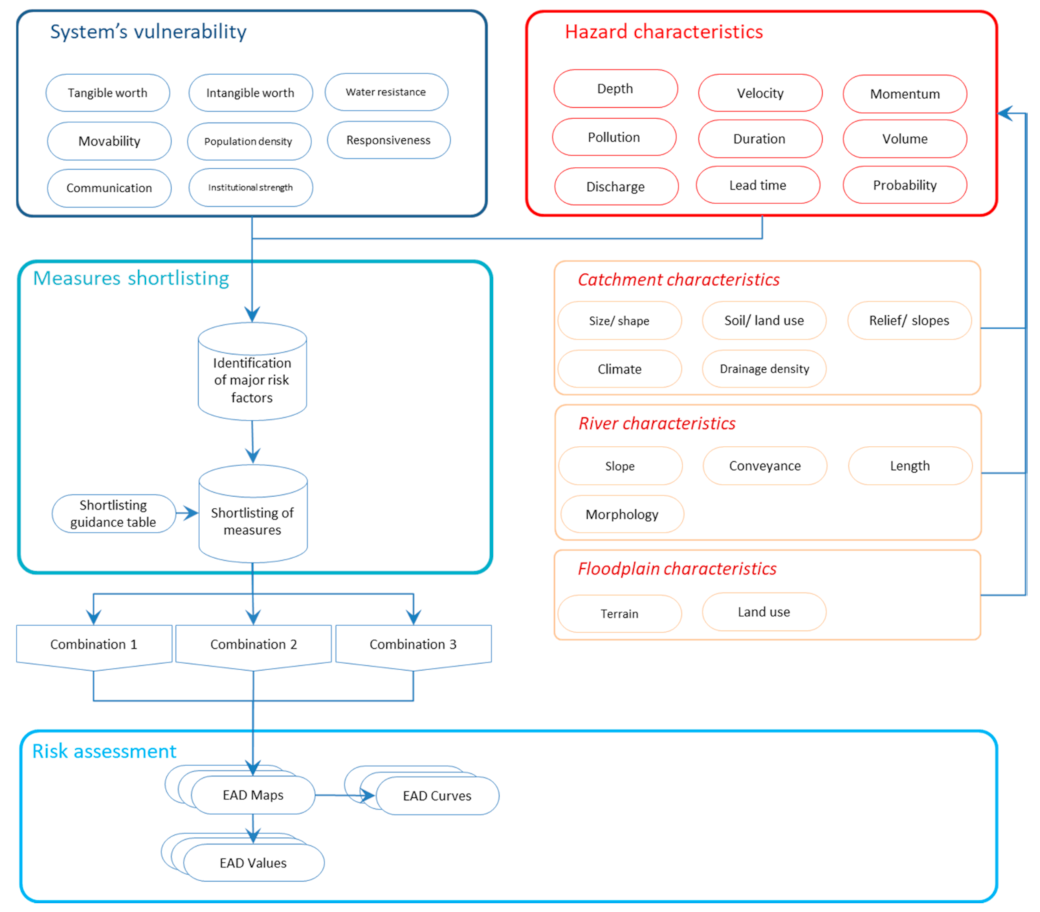
Human society must adopt a risk management strategy in order to coexist harmoniously with flood events. In fact, it will never be possible to eliminate the risk of floods. Nevertheless, appropriate actions and behaviors can mitigate the consequences of flooding [29]. Complete abandonment of floodplains or full flood control could be extreme reactions to flooding, but these reactions could either be practically impossible or emphatically uneconomical. The basic principle of flood risk management should be “adjusting from both ends to achieve moderation” [30]. Vulnerability and/or hazard parameters can be adjusted to improve the floodplains’ functions. A proposed framework is explained in Figure 2 to explore all available options in a systematic way to reduce the flood risk.
The advantage of a risk-based strategy is that it trades outcomes, which separates it from other design or decision-making methods [31]. Risk-based land-use planning in a floodplain is capable of providing a non-structural means of lowering flood losses and harmonizing floodplain activities. There is a strong need for more comprehensive studies on flood vulnerability [11]. Therefore, recent research indicates a risk-based approach to flood management [10,32,33,34]. Risk-based management counts every aspect of risk (flood impacts) and also considers all options to manage it the most efficiently [35]. In this way, risk-based assessment not only leads to an optimum flood management plan, but also creates an understanding of the mechanism generating the risk.
3.1. Flood Impacts
Flood impacts may include damage, disruptions, restructuring, compensation, and management expenses. There are a significant number of positive and adverse consequences of floods [24]. These consequences can be classified according to the following criteria:
- Type of impact: Whether flooding is causing a positive impact or a negative
- Connection with the flood:
- Primary: Not direct, but still occurred within the floodplain
- Secondary: The impact is not within the floodplain
- Induced: Efforts to manage floods
- Tangible: Whether it can be expressed simply in currency terms
- Intangible: If the impacts have a social and/or emotional value
Practical examples are provided in Table 2.
3.2. Flood Risk: Definitions and Parameters
The main objective of this research is to provide a basic framework to develop a risk-based flood management strategy for a floodplain. A first task is to put together various views of what constitutes “risk” in general, and flood risk in particular. The research also discusses how flood risk evolves, what the causes of this development are, how they can be affected so as to mitigate the risks (by what points of attack and by what measures), and how these can be combined. A detailed explanation of risk-based management is carried out in order for a better understanding of the approach. In addition, for clear comprehension and to avoid ambiguity and misconceiving, the basic terms involved have been defined here. Although there is a general agreement on most of the definitions, some terms are used for different meanings by some scientists.
3.3. Risk Perception
The term risk has been defined and understood in many instances to have somewhat similar meanings. Emphasis has been placed on various elements when being defined by different scientists, as follows:
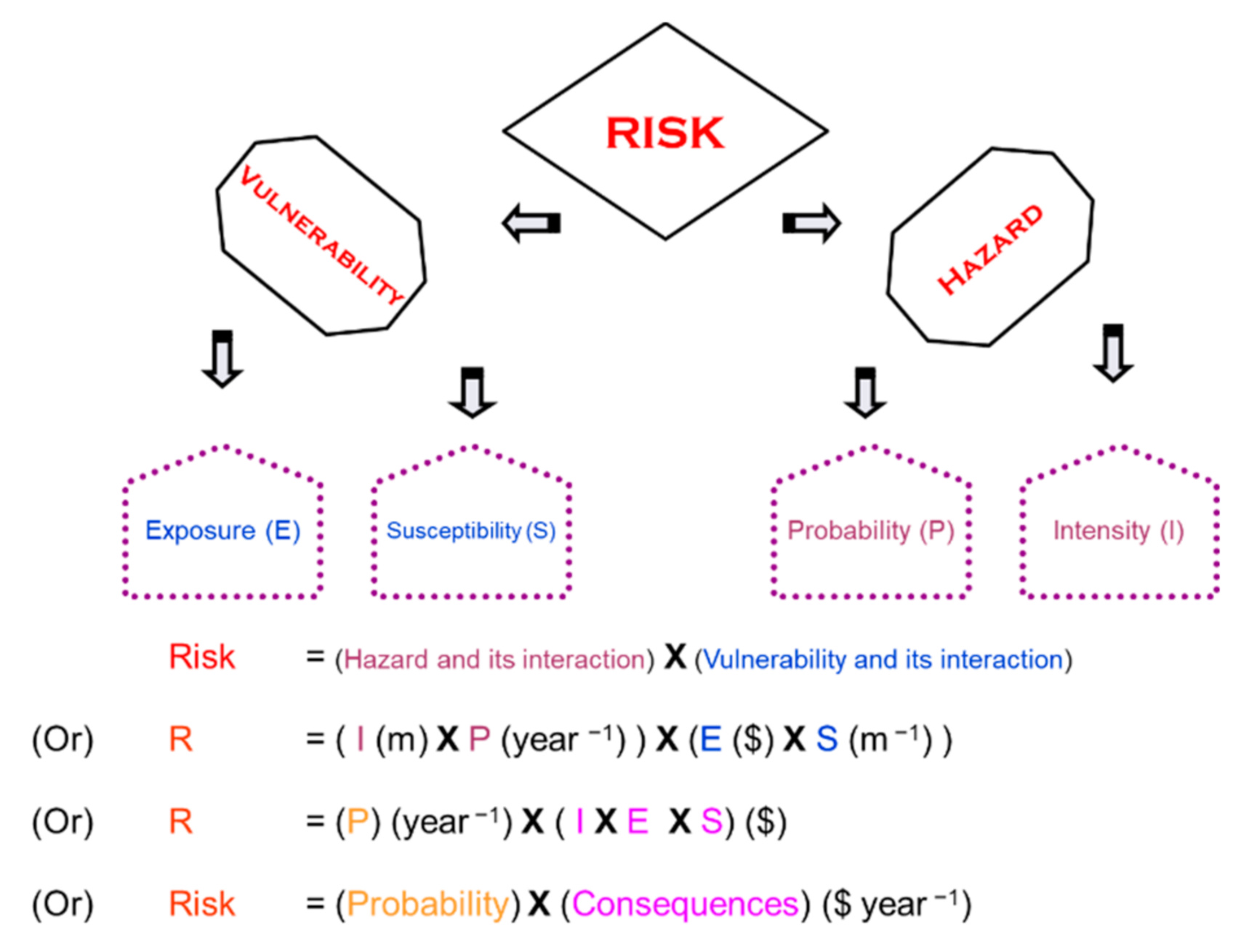
- Risk = hazard × vulnerability [41]
Overall, the term “risk” is somehow is related with the vulnerability, hazard, impacts values, elements at risk, preparedness of the people, results or the consequences, and the chances of all of these happening (these factors have also been differently defined). Risk may be generally envisioned as “an estimate of potential consequences associated with a hazard”. The following section provides further understanding of risk, and proves how various definitions of risk are representing the same concept, just in different terms.
3.4. Risk Parameters
Risk-based assessment evaluates flood measurements based on potential impacts, while reducing negative impacts of floods, such as socioeconomic and environmental factors. This method provides a logical ground to shortlist and finalize flood management options. Understanding risk concepts, elaboration of the role of the river process, and societal activities should be considered during the assessment. Risk can be broadly defined as “an estimation of expected results connected to a hazard”.
Risk ($ year−1) = Probability (year−1) × Consequences ($)
Also, the risk is a function of how vulnerability interacts with hazard or vice versa.
Risk ($ year−1) = Hazard (m year−1) × Vulnerability ($m−1)
The above-stated term indicates that the hazard itself is not the only cause for risk induction. Everyday vulnerability and hazards shape trends of rising risk, which can end in a catastrophe arising from an exceptionally natural incident [54]. Therefore, two independent variables are considered for risk analysis—hazard and vulnerability. In flood management, the term “hazard” indicates the occurrence of a high-water-level event with a given probability of exceedance [55]. Thus, the hazard may be classified by its intensity and probability.
Hazard (m year−1) = Probability (P) (year−1) × Intensity (I) (m)
Probability can be defined as the chance of a hazard to occur that can be defined annually for a flood event. While some negative intensity features (depth, velocity, etc.) of hazards cause damage, vulnerability is the outcome of susceptibility and exposure.
where people and value currently exist in an under-threat region is known as exposure. Susceptibility is generally defined as the relative loss function [56,57]. The ability to recognize the losses from the hazard is susceptibility. The extent of loss is based on the susceptibility of vulnerable items and life, and indeed the magnitude of hazard. In order to comprehend the role of both sides, risk in terms of vulnerability and hazard needs to be articulated, as illustrated in Equation (2). Thus, we get Equation (5) by substituting vulnerability and hazard by their components in Equation (2). Likewise, expressing probability alone will result in Equation (6).
Vulnerability ($m−1) = Susceptibility (S) (m−1) × Exposure (E) ($)
Risk = [P × I] (m year−1) × [S × E] ($m−1)
Risk = P × [I × S × E] ($ year−1)
If the chance of the mutual interaction of vulnerability and hazard is considered separately, the consequences are definitely as a result of a hazard’s intensity, and the total exposures of assets and how much they accept the damage from the hazard (the susceptibility). It can be observed that Equation (6) is an elaborated expression of Equation (2). A graphical demonstration is shown in Figure 3 below.
3.5. Scheme of Measures
Flood management options can be defined as those that reduce challenges and those that enhance the individual and societal ability to cope with a flood. Typically, a mixture of methods would be the most effective management technique. There is an inversely proportional impact of probability on vulnerability. Normally, floods that occur more frequently are more adequately responded to, and therefore cause less harm. Quite rarely, (extreme) floods can cause significant harm. In areas that are located away from the river, these types of losses primarily occur. Because of more exposure and higher susceptibility, vulnerability rises as people who live far from the river do not expect a flood. The risk of occurrence primarily defines the magnitude of the protection measures initiated in a floodplain. Flood-suffering areas also implement infrastructure steps, such as floodproofing, etc. Flood interventions are highly dependent on risk factors, as well as technological, financial, and social constraints, for their efficacy and suitability.
Therefore, comparisons are made between alternatives, and evaluations are usually comparative. Therefore, the advantages and drawbacks of one alternative exist only in comparison with those of another. Identifying the potential role of one strategy in managing flood hazards includes identifying the potential roles of all other flood hazard management strategies at the same time. Compared with the best choices, the solution found through the evaluation process cannot be any better. Therefore, it is important to allow a sufficient range of options if the best choice among them is to be sought. While some guidelines have been suggested to maximize the probability of choosing the best alternative among those considered, the most effective method is to include the public in defining both important problems and potential solutions early on.
3.6. Assorting Suitable Measures
Detailed risk assessment of all possible flood management measures is not economically feasible. A competent professional with knowledge of the domain of flood management while using available data can discard certain flood management options without going into a deep analysis [58]. Similarly, certain measures are preferable under certain prevailing conditions. For example, floodproofing of individual areas within the floodplain has been proven to be more economically feasible compared with flood protection by constructing dykes under conditions where the floodplain is not densely populated. Some measures are highly counterproductive in certain situations. One example is constructing a dyke in a mountainous area, where flood levels fluctuate more rapidly and chances of dyke failure are high. In this case, the dyke prevents the floodwaters from receding once the flood peak has passed. The selection of a suitable measure is done by considering the appraisal needs and the contribution of the measures in achieving appraisal objectives.
Different flood management options should be evaluated one by one by approximation. Developing options correctly can save time and resources. The following steps are recommended in order to develop the most suitable combination suited to appraisal needs:
- Identification of a wide range of options considering the topographical, environmental, social, and cost-effective constraints
- Screening out impractical and infeasible options
- Shortlisting options that most probably can achieve the best use of resources
- Development of a wide range of options by combining different combinations of measures
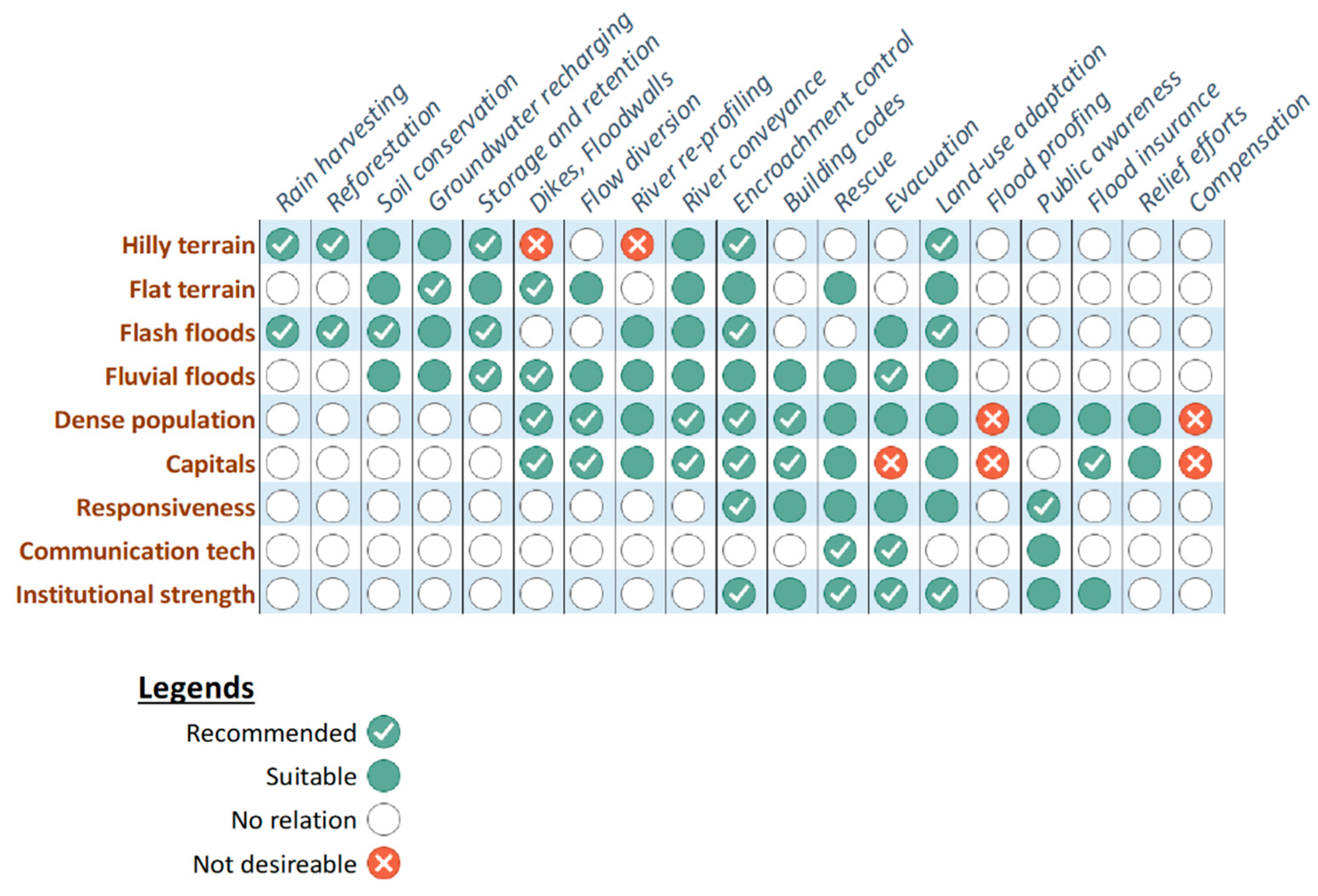
Figure 4 provides a rule-of-thumb guideline example in order to shortlist the measures under the predominant conditions of the floodplain. The data are compiled based on extensive literature review [2,5,16,19,29,33,59,60,61,62,63,64] and field experts’ opinions. Plenty of case studies were observed and their preferred approaches were noted. Figure 4 is developed after detailed brainstorming sessions with field experts. This guidance is tentative and is based on a range of typical benefits, including reduced costs and additional socio-environmental benefits.
3.6.1. Suitable Measures at Catchment
Catchment management can be an effective option with or without the support of other measures. Some land-use practices can increase the tendency of rapid and high peak runoff, especially if the soil surface is left bare for long periods of the year, or periods when heavy drainage is more likely [59,65]. Not only land use, but also installing meteorological and hydrometric telemetric stations in the basin, is important for an effective flood forecast-warning system. It is important to record meteorological and hydrometric data in real-time [66]. In most cases, there is ample time to identify and notify the local authorities of an oncoming significant flood event [60].
Agricultural activities play a significant role in the generation of total volume and peak flow. For example, livestock above certain densities can lead to soil compaction (which increases rapid surface runoff) and the loss of water to evapotranspiration is minimized by reducing biomass, thereby increasing the runoff [67]. The way the catchment’s surface is controlled by tillage will influence rapid runoff for a given land-use [68]. Through evapotranspiration, trees can increase water loss and increase infiltration via their root networks, both reducing overland flow generation [69]. Watershed protection steps can also be seen in watershed planning from the perspective of soil conservation, economic and agricultural aspects, and recreational concerns [70].
In the case of hill torrents/flash floods, the most effective measures lie with catchment management. A sudden increase in torrent kinetic energy may occur in the high regions. Technical interventions, such as tanks and inhibitory dams, can be designed for flood interception before the floods start heading to the low regions [66]. Steps taken at the catchment may help to de-synchronize the accumulation of water at points where the torrent’s kinetic energy is increased. Furthermore, forest conservation measures should be considered, as they play a significant role in the prevention of flood phenomena [66].
3.6.2. Suitable Measures at the River
There are fewer options that can be taken at the river to interrupt the floods, such as shielding banks from erosion and increasing the conveyance of the channel [66]. The rate of flow conveyance, an inverse function of the attenuation rate in the absence of tributary inflows, depends on river and floodplain roughness; by increasing river roughness, the flow tends to deepen in the river and more easily cause flooding. As floodplain flows are generally shallow, they appear to be sluggish, and so attenuation will increase [59,71]. Excavation should be easily feasible; that is, no bedrock should be found within the diversion excavation depth. Another important consideration is that either a natural body of water should be available to dispose of the diverted water, or enough gradient should be available to drop the water back into the river without having a significant backwater effect [58].
3.6.3. Suitable Measures at Floodplain
Densely populated and high economic growth areas have been protected by building dykes. The construction and maintenance cost of dykes can be justified for the level of protection they provide to the floodplain [72]. Klijn et al. [73] investigated the enhanced exposure and increased vulnerability of The Netherlands’ defense system and found that the risk was increased because of increased vulnerability. However, floodproofing or relocation can be considered if it is a small town or if there are only a few houses in the region to be covered from potential flooding. Relocation is an option only when damage is high and there is no economic reason for any other choices. Medium–low economic growth limits the deployment of costly defense systems to high-risk areas [62]. In addition, in a region with a clay soil type, the construction of a dyke is not the preferred choice [58]. Because of environmental concerns, a dyke is not recommended where there are wetlands or marshes in the region, because they dry out in the absence of regular recharging by natural floods [58].
Water storage, artificial groundwater recharging basins, and wetlands have multiple benefits in addition to flood attenuation. Artificial groundwater recharging is one of the effective options to handle flash flooding [66]. However, many considerations are required in order to implement the option. For a single location to be protected from flooding, reservoirs are not an option, unless the project can be economically justified by considering additional uses, such as hydropower generation, water supply, recreation, etc. Most essential of all, a suitable place should be available for building a reservoir [58]. Farmers’ willingness to allow flooding to their land is very necessary for the option of the retention basin. Water-logging (high groundwater levels) in the region should not be serious. There should be no historical site of significance, or it should be possible to protect the site from the damage caused by managed flooding by building a dyke around it or by any other steps [58].
3.6.4. Interconnected Suitability of Measures
Flood management measures are strongly connected, and their performance is affected when applied in combination. For example, if the majority of the watershed is barren ground, dredging should not be considered, as surface runoff would carry tons of sediment. Water-logging should not be serious, as there will be a lack of additional capacity due to increased groundwater flow into the system. Dredging is not an option if the river has a serious sedimentation problem. Preferably, the additional river capacity needed to handle damaging floods should be equal to or less than 50% of the current river capacity [58].
In addition, few measures are alternative and exclusive to each other. For example, Hsieh et al. [61] evaluated three mitigation steps for flood-prone lowlands with a high population density along the Keelung River in Taiwan, including dykes, a drainage channel, and a storage reservoir. A diversion channel was proven to be more feasible than the other two flood mitigation options because of the high population and economic activity concentration in the floodplain. Where budgets are too poor to support defenses, successful, controlled realignment, or planned destruction will occur, with habitat recreation where necessary [62]. Dixon et al. [59] found that for smaller drainage basins, usually less than 100 km2, the restoration of the river channel morphology and floodplain forest can be the basis of flood risk mitigation.
3.7. Software Tools
Several tools/software programs have been developed to carry out flood simulations in order to estimate flood damage/risk. The methodology/approaches of these tools vary at a large scale, extending from hydrodynamic modeling to statistical, artificial intelligence-based, and even stage-damage or discharge damage empirical models. The majority of tools are hydrodynamic models that simulate the flood wave in 1D, 2D, and 3D [74,75]. These include models that have compatibility with geographic information systems (GIS) [76]. A few tools have additional extensions/modules to perform statistical analysis and damage calculations as well. The inclusion of GIS capabilities has become more popular in recent years in hydrodynamic models. However, damage estimation tools recognize GIS capabilities on a larger scale. Most common software takes basic hydrologic, hydraulic, and topographical inputs to simulate flooding, while others estimate the flood damage considering the depth of flood and land-uses parameters in an empirical way. Table 3 lists a few software tools, along with their capability for GIS and country of origin.
3.8. Practical Examples
A few case studies are already being carried out under the defined framework. However, there are some good examples that can explain parts of the framework with real examples of flood management. Klijn, F. et al. [73] explained various concepts of risk-based flood management and provided initial suggestions to approach towards risk reduction. Two case studies have been referred to in order to demonstrate flood adaptations (vulnerability adjustments). Jukrkorn, N. [77] performed an ex-post analysis of a 2011 flood in central Thailand, and discussed the selection of various flood measures and their integration to a well-connected system. Agent-based modeling was performed by Yared, A. A. et al. [78], where they studied the impact of hazard reduction and vulnerability control in Sint Maarten. Another case study conducted by Rogger, M. et al. [79] explained land use effects in catchment on flood management with supporting options. Serre, D. et al. [80] explained the effectiveness of structural and non-structural measures regarding a few historic floods in Europe and the USA.
4. Conclusions and Recommendations
The concept of risk-based flood management is not new and has evolved over time. Risk-based flood management is replacing the probability-based (return period) approach, but the design standards, implementation procedures, and detailed protocols are yet to be determined. Risk-based flood management is popular and has received broader appraisal in many parts of the world, yet the approach needs a few finer refinements before being accepted as a standard approach at national levels.
Comprehending the role of risk parameters is important for the scrutiny of flood management schemes. A careful valuation of the economic, social, and environmental assets is indispensable in order to develop a balanced flood management approach. Understanding risk phenomenon is very important in order to devise the most effective solutions under the socioeconomic and environmental constraints. The basis of effective and efficient risk reduction measures lies in risk assessment, which considers the different aspects of flood risk, e.g., hydrological, hydraulic, economic, social, and ecological aspects. The presented risk definition and mechanism provide a standardized approach and establish common grounds to compare different flood management options.
Many options and measures exist for flood management. Their effectiveness, suitability, and role within a plan are highly associated with the characteristics of a floodplain and the combination of measures selected. Every floodplain has its own circumstances and needs a tailor-made solution based on thorough analysis. The initial shortlisting of measures should be done considered alongside other models suitability matched to the floodplain, as well as the combined efficiency of the measures themselves. However, the final scheme of measures must undergo a detailed risk assessment.
Author Contributions
Conceptualization, M.A.U.R.T. and N.v.d.G.; Data curation, M.A.U.R.T.; Formal analysis, M.A.U.R.T. and R.F.; Investigation, M.A.U.R.T. and R.F.; Methodology, M.A.U.R.T. and R.F.; Software, M.A.U.R.T. and R.F.; Supervision, M.A.U.R.T. and N.v.d.G.; Validation, M.A.U.R.T.; Visualization, M.A.U.R.T. and R.F.; Writing—original draft, M.A.U.R.T. and R.F.; Writing—review & editing, M.A.U.R.T. All authors have read and agreed to the published version of the manuscript.
Funding
This research received no external funding.
Conflicts of Interest
The authors declare no conflict of interest.
References
- Kousky, C. Who holds on to their flood insurance. Common Resour. 2015. [Google Scholar]
- Loster, T. Flood trends and Global Change. In Proceedings of the EuroConference on Global Change and Catastrophe Risk Management: Flood Risks in Europe, Laxenburg, Austria, 6–9 June 1999. [Google Scholar]
- Hassan, F.; Hamdan, M.A.; Flower, R.J.; Shallaly, N.; Ebrahem, E. Holocene alluvial history and archaeological significance of the Nile floodplain in the Saqqara-Memphis region, Egypt. Quat. Sci. Rev. 2017, 176, 51–70. [Google Scholar] [CrossRef]
- Manning, J.G.; Ludlow, F.; Stine, A.R.; Boos, W.R.; Sigl, M.; Marlon, J.R. Volcanic suppression of Nile summer flooding triggers revolt and constrains interstate conflict in ancient Egypt. Nat. Commun. 2017, 8, 900. [Google Scholar] [CrossRef] [PubMed] [Green Version]
- Aronica, G.T.; Candela, A.; Fabio, P.; Santoro, M. Estimation of flood inundation probabilities using global hazard indexes based on hydrodynamic variables. Phys. Chem. Earth Parts A/B/C 2012, 42, 119–129. Available online: http://0-www-sciencedirect-com.brum.beds.ac.uk/science/article/pii/S1474706511000568 (accessed on 15 June 2020). [CrossRef]
- Plate, E.J. Flood risk and flood management. J. Hydrol. 2002, 267, 2–11. Available online: http://0-www-sciencedirect-com.brum.beds.ac.uk/science/article/B6V6C-46HBKF8-4/2/93f2763765cd0bad006fed4cfc6fa5c1 (accessed on 15 June 2020). [CrossRef]
- FEMA. Flood Insurance Manual; FEMA: Washington, DC, USA, 2008.
- Agency, E. Understanding Flood Risk Using Our Flood Map; Identifying and understanding Flood Risk in England & Wales; Environment Agency: Bristol, UK, 2006. Available online: www.environment-agency.gov.uk/floodmap (accessed on 15 June 2020).
- De Moel, H.; Aerts, J.C.; Koomen, E. Development of flood exposure in the Netherlands during the 20th and 21st century. Glob. Environ. Chang. 2011, 21, 620–627. [Google Scholar] [CrossRef]
- De Moel, H.; Van Alphen, J.; Aerts, J.C.J.H. Flood maps in Europe—Methods, availability and use. Nat. Hazards Earth Syst. Sci. 2009, 9, 289–301. [Google Scholar] [CrossRef] [Green Version]
- Merz, B.; Thieken, A.H.; Gocht, M. Flood risk mapping at the local scale: Concepts and challenges. In Flood Risk Management in Europe; Begum, S., Ed.; Springer: Berlin/Heidelberg, Germany, 2007; pp. 231–251. [Google Scholar]
- Linde, A.H.T.; Bubeck, P.; Dekkers, J.E.C.; De Moel, H.; Aerts, J.C.J.H. Future flood risk estimates along the river Rhine. Nat. Hazards Earth Syst. Sci. 2011, 11, 459–473. [Google Scholar] [CrossRef] [Green Version]
- Cabal, A.; Erlich, M. Flood risk management approaches and tools for mitigation strategies of coastal submersions and preparedness of crisis management in France. Int. J. River Basin Manag. 2018, 16, 353–369. [Google Scholar] [CrossRef]
- Tariq, M.A.U.R.; Van De Giesen, N. Floods and flood management in Pakistan. Phys. Chem. Earth Parts A/B/C 2012, 47–48, 11–20. [Google Scholar] [CrossRef]
- De Bruijn, K.; Green, C.; Johnson, C.; McFadden, L. Evolving concepts in flood risk management: Searching for a common language. In Flood Risk Management in Europe; Springer: Berlin/Heidelberg, Germany, 2007; pp. 61–75. [Google Scholar]
- Van Duivendijk, J. Assessment of Flood Control and Management Options; World Commission on Dams: Cape Town, South Africa, 1999. [Google Scholar]
- White, G.F. White, Natural Hazards, Local, National, Global; Oxford University Press: New York, NY, USA, 1974. [Google Scholar]
- Tariq, M.A.U.R.; Hoes, O.; Van De Giesen, N. Development of a risk-based framework to integrate flood insurance. J. Flood Risk Manag. 2013, 7, 291–307. [Google Scholar] [CrossRef]
- Andjelkovic, I. Guidelines on Non-Structural Measures in Urban Flood Management; UNESCO, International Hydrological Programme: Paris, France, 2001. [Google Scholar]
- Green, C.; Nicholls, R.; Johnson, C. Climate Change Adaptation: A Framework for Analysis and Decision-Making in the Face of Risks and Uncertainties; FHRC, Middlesex University: Middlesex, UK, 2000. [Google Scholar]
- Tucci, C.E.M. Urban Flood Management; World Meteorological Organization: Porto Alegre, Brazil, 2007. [Google Scholar]
- Genovese, E. A Methodological Approach to Land Use-Based Flood Damage Assessment in Urban Areas: Prague Case Study; Institute for Environment and Sustainability: Ispra, Italy, 2006. [Google Scholar]
- Tariq, M.A.U.R. Risk-based flood zoning employing expected annual damages: The Chenab River case study. Stoch. Environ. Res. Risk Assess. 2013, 27, 1957–1966. [Google Scholar] [CrossRef]
- Door, K.; de Bruijn, M.; van Beek, E. Resilience and Flood Risk Management: A Systems Approach Applied to Lowland Rivers; Technische Universiteit Delft: Delft, The Netherlands, 2005. [Google Scholar]
- APFM. Integrated Flood Management Concept Paper; World Meteorological Organization: Geneva, Switzerland, 2009. [Google Scholar]
- APFM. Economic Aspects of Integrated Flood Management; Associated Programme on Flood Management: Geneva, Switzerland, 2007; ISBN 92-63-11010-7. [Google Scholar]
- Pilon, P.J.; Davis, D.A.; Halliday, R.A.; Paulson, R. Guidelines for Reducing Flood Losses; Inter-Agency Secretariat of the International Strategy for Disaster Reduction (UN/ISDR): Geneva, Switzerland, 2003. [Google Scholar]
- Hoes, O.; Schuurmans, W. Flood standards or risk analyses for polder management in the Netherlands. Irrig. Drain. 2006, 55, S113–S119. [Google Scholar] [CrossRef]
- Borrows, P.; De Bruin, D. The management of riverine flood risk. Irrig. Drain. 2006, 55, S151–S157. [Google Scholar] [CrossRef]
- Cheng, X. Recent progress in flood management in China. Irrig. Drain. 2006, 55, S75–S82. [Google Scholar] [CrossRef]
- Sayers, P.B.; Gouldby, B.P.; Simm, J.D.; Meadowcroft, I.; Hall, J. Risk, Performance and Uncertainty in Flood and Coastal Defence: A Review; HR Wallingford Report SR 587; Environment Agency DEFRA/EA R&D Technical Report FD2302/TR1; HR Wallingford: Wallingford, UK, 2002. [Google Scholar]
- Hooijer, A.; Klijn, F.; Pedroli, G.B.M.; Van Os, A. Towards sustainable flood risk management in the Rhine and Meuse river basins: Synopsis of the findings of IRMA-SPONGE. River Res. Appl. 2004, 20, 343–357. [Google Scholar] [CrossRef]
- Van Alphen, J.; Lodder, Q. Integrated flood management: Experiences of 13 countries with their implementation and day-to-day management. Irrig. Drain. 2006, 55, S159–S171. [Google Scholar] [CrossRef]
- Petrow, T.; Merz, B.; Lindenschmidt, K.-E.; Thieken, A.H. Aspects of seasonality and flood generating circulation patterns in a mountainous catchment in south-eastern Germany. Hydrol. Earth Syst. Sci. 2007, 11, 1455–1468. [Google Scholar] [CrossRef] [Green Version]
- Hooijer, A.; Klijn, F.; Kwadijk, J. (Eds.) Towards Sustainable Flood Risk Management in the Rhine and Meuse River Basins; Main Results IRMA Sponge Res. Proj. NCR-Publication 18-2002; NCR: Delft, The Netherlands, 2002. [Google Scholar]
- Merz, B.; Kreibich, H.; Thieken, A.; Schmidtke, R. Estimation uncertainty of direct monetary flood damage to buildings. Nat. Hazards Earth Syst. Sci. 2004, 4, 153–163. [Google Scholar] [CrossRef] [Green Version]
- Nascimento, N. Flood-damage curves: Methodological development for the Brazilian context. Water Pract. Technol. 2006, 1. [Google Scholar] [CrossRef]
- Oosterhaven, J.; Többen, J. Wider economic impacts of heavy flooding in Germany: A non-linear programming approach. Spat. Econ. Anal. 2017, 12, 404–428. [Google Scholar] [CrossRef] [Green Version]
- Smith, K.; Ward, R. Floods: Physical Processes and Human Impacts; John Wiley and Sons: Hoboken, NJ, USA, 1998. [Google Scholar]
- Hudson, P.; Botzen, W.J.W.; Poussin, J.; Aerts, J.C.J.H. Impacts of Flooding and Flood Preparedness on Subjective Well-Being: A Monetisation of the Tangible and Intangible Impacts. J. Happiness Stud. 2017, 20, 665–682. [Google Scholar] [CrossRef]
- UNDHA. Internationally Agreed Glossary of Basic Terms Related to Disaster Management; United Nations Department of Humanitarian Affairs: Geneva, Switzerland, 1992. [Google Scholar]
- Blong, R. Volcanic hazards risk assessment. In Monitoring and Mitigation of Volcano Hazards; Scarpa, R., Tilling, R.I., Eds.; Springer: Berlin/Heidelberg, Germany; New York, NY, USA, 1996; p. 23. [Google Scholar]
- Santos, P.P. A comprehensive approach to understanding flood risk drivers at the municipal level. J. Environ. Manag. 2020, 260, 110127. [Google Scholar] [CrossRef] [PubMed]
- La Cruz-Reyna, S.D. Long-term probabilistic analysis of future explosive Eruptions. In Monitoring and Mitigation of Volcano Hazards; Scarpa, R., Tilling, R.I., Eds.; Springer: Berlin/Heidelberg, Germany; New York, NY, USA, 1996. [Google Scholar]
- Kron, W.; Eichner, J.; Kundzewicz, Z. Reduction of flood risk in Europe—Reflections from a reinsurance perspective. J. Hydrol. 2019, 576, 197–209. [Google Scholar] [CrossRef]
- Crichton, D. The risk triangle. In Natural Disaster Management; Ingleton, J., Ed.; Tudor Rose: London, UK, 1999; p. 2. [Google Scholar]
- Granger, K.; Jones, T.; Leiba, M.; Scott, G. Community Risk in Cairns: A Multi-Hazard Risk Assessment; AGSO (Australian Geological Survey Organisation): Canberra, Australia, 1999.
- Smith, K. Environmental Hazards: Assessing Risk and Reducing Disaster; Routledge: London, UK, 1996. [Google Scholar]
- Helm, P. Integrated Risk Management for Natural and Technological Disasters. Tephra 1996, 9, 15. [Google Scholar]
- Sayers, P.B.; Gouldby, B.P.; Simm, J.D.; Meadowcroft, I.; Hall, J. Risk, Performance and Uncertainty in Flood and Coastal Defence—A Review R&D Technical Report FD2302/TR1. Defra/Environment Agency. 2003. Available online: www.defra.gov.uk/environ/fcd/research (accessed on 15 June 2020).
- Kron, W. Flood Risk = Hazard X exposure X vulnerability. J. Lake Sci. 2003, 15, 185–204. [Google Scholar] [CrossRef] [Green Version]
- Ciullo, A.; Viglione, A.; Castellarin, A.; Crisci, M.; Di Baldassarre, G. Socio-hydrological modelling of flood-risk dynamics: Comparing the resilience of green and technological systems. Hydrol. Sci. J. 2017, 62, 880–891. [Google Scholar] [CrossRef] [Green Version]
- Knighton, J.; Steinschneider, S.; Walter, T. A Vulnerability-Based, Bottom-up Assessment of Future Riverine Flood Risk Using a Modified Peaks-Over-Threshold Approach and a Physically Based Hydrologic Model. Water Resour. Res. 2017, 53, 10043–10064. [Google Scholar] [CrossRef]
- Pelling, M.; Maskrey, A.; Ruiz, P.; Hall, L. Reducing Disaster Risk: A Challenge for Development. United Nations Development Programme, Bureau for Crisis Prevention and Recovery; John S. Swift Co., Inc.: New York, NY, USA, 2004. [Google Scholar]
- Kron, A. Flood damage estimation and flood risk mapping. In Advances in Urban Flood Management; Ashley, R., Garvin, S., Pasche, E., Vassilopoulos, A., Zevenbergen, C., Eds.; Taylor & Francis/Balkema: Leiden, The Netherlands, 2007; pp. 213–235. [Google Scholar]
- Merz, B.; Kreibich, H.; Schwarze, R.; Thieken, A. Review article “Assessment of economic flood damage”. Nat. Hazards Earth Syst. Sci. 2010, 10, 1697–1724. [Google Scholar] [CrossRef]
- Messner, F.; Penning-Rowsell, E.; Green, C.; Meyer, V.; Tunstall, S.; van der Veen, A. Evaluating flood damages: Guidance and recommendations on principles and methods. FLOODsite Consort. 2007, 189. [Google Scholar]
- Ahmad, S.; Simonovic, S.P. Integration of heuristic knowledge with analytical tools for the selection of flood damage reduction measures. Can. J. Civ. Eng. 2001, 28, 208–221. [Google Scholar] [CrossRef]
- Dixon, S.J.; Sear, D.A.; Odoni, N.A.; Sykes, T.; Lane, S.N. The effects of river restoration on catchment scale flood risk and flood hydrology. Earth Surf. Process. Landforms 2016, 41, 997–1008. [Google Scholar] [CrossRef]
- Kourgialas, N.N.; Karatzas, G.P.; Nikolaidis, N.P. Development of a thresholds approach for real-time flash flood prediction in complex geomorphological river basins. Hydrol. Process. 2011, 26, 1478–1494. [Google Scholar] [CrossRef]
- Hsieh, L.-S.; Hsu, M.-H.; Li, M.-H. An Assessment of Structural Measures for Flood-prone Lowlands with High Population Density along the Keelung River in Taiwan. Nat. Hazards 2006, 37, 133–152. [Google Scholar] [CrossRef]
- Dawson, R.; Ball, T.; Werritty, J.; Werritty, A.; Hall, J.W.; Roche, N. Assessing the effectiveness of non-structural flood management measures in the Thames Estuary under conditions of socio-economic and environmental change. Glob. Environ. Chang. 2011, 21, 628–646. [Google Scholar] [CrossRef]
- Van Duivendijk, J. The systematic approach to flooding problems. Irrig. Drain. 2006, 55, S55–S74. [Google Scholar] [CrossRef]
- Rikz, R.W.S. Atlas of Flood Maps; Examples from 19 European Countries, USA and Japan; WL Delft Hydraulics: Delft, The Netherlands, 2007. [Google Scholar]
- Evans, R.; Boardman, J. Curtailment of muddy floods in the Sompting catchment, South Downs, West Sussex, southern England. Soil Use Manag. 2003, 19, 223–231. [Google Scholar] [CrossRef]
- Kourgialas, N.N.; Karatzas, G.P. Flood management and a GIS modelling method to assess flood-hazard areas—A case study. Hydrol. Sci. J. 2011, 56, 212–225. [Google Scholar] [CrossRef]
- Orr, H.G.; Carling, P.A. Hydro-climatic and land use changes in the River Lune catchment, North West England, implications for catchment management. River Res. Appl. 2006, 22, 239–255. [Google Scholar] [CrossRef]
- Holman, I.P.; Hollis, J.M.; Bramley, M.E.; Thompson, T.R.E. The contribution of soil structural degradation to catchment flooding: A preliminary investigation of the 2000 floods in England and Wales. Hydrol. Earth Syst. Sci. 2003, 7, 755–766. [Google Scholar] [CrossRef] [Green Version]
- Marc, V.; Robinson, M. The long-term water balance (1972–2004) of upland forestry and grassland at Plynlimon, mid-Wales. Hydrol. Earth Syst. Sci. 2007, 11, 44–60. [Google Scholar] [CrossRef] [Green Version]
- Yazdi, J.; Neyshabouri, S.A.A.S.; Niksokhan, M.H.; Sheshangosht, S.; Elmi, M. Optimal prioritisation of watershed management measures for flood risk mitigation on a watershed scale. J. Flood Risk Manag. 2013, 6, 372–384. [Google Scholar] [CrossRef]
- Dixon, S.J.; Sear, D.A.; Nislow, K.H. A conceptual model of riparian forest restoration for natural flood management. Water Environ. J. 2018, 33, 329–341. [Google Scholar] [CrossRef]
- Tariq, M.A.U.R.; Hoes, O.; Ashraf, M.T. Risk-Based Design of Dike Elevation Employing Alternative Enumeration. J. Water Resour. Plan. Manag. 2014, 140, 05014002. [Google Scholar] [CrossRef]
- Klijn, F.; Kreibich, H.; De Moel, H.; Penning-Rowsell, E.C. Adaptive flood risk management planning based on a comprehensive flood risk conceptualisation. Mitig. Adapt. Strat. Glob. Chang. 2015, 20, 845–864. [Google Scholar] [CrossRef] [Green Version]
- Huang, J. Numerical Study on the Impact of Revising the Rainstorm Intensity Formula on the Storm Flood Disaster Prediction in Huinan, Pudong District. J. Civ. Eng. Constr. 2018, 7, 19. [Google Scholar] [CrossRef] [Green Version]
- Macchione, F.; Costabile, P.; Costanzo, C.; De Lorenzo, G.; Razdar, B. Dam breach modelling: Influence on downstream water levels and a proposal of a physically based module for flood propagation software. J. Hydroinform. 2015, 18, 615–633. [Google Scholar] [CrossRef]
- Albano, R.; Mancusi, L.; Sole, A.; Adamowski, J. FloodRisk: A collaborative, free and open-source software for flood risk analysis. Geomat. Nat. Hazards Risk 2017, 8, 1812–1832. [Google Scholar] [CrossRef] [Green Version]
- Jukrkorn, N.; Sachdev, H.; Panya, O. Community-based flood risk management: Lessons learned from the 2011 flood in central Thailand. Flood Recovery Innov. Response IV 2014, 184, 75–86. [Google Scholar] [CrossRef] [Green Version]
- Abebe, Y.A.; Ghorbani, A.; Nikolic, I.; Vojinovic, Z.; Sanchez, A. Flood risk management in Sint Maarten—A coupled agent-based and flood modelling method. J. Environ. Manag. 2019, 248, 109317. [Google Scholar] [CrossRef]
- Rogger, M.; Agnoletti, M.; Alaoui, A.; Bathurst, J.C.; Bodner, G.; Borga, M.; Chaplot, V.; Gallart, F.; Glatzel, G.; Hall, J.; et al. Land use change impacts on floods at the catchment scale: Challenges and opportunities for future research. Water Resour. Res. 2017, 53, 5209–5219. [Google Scholar] [CrossRef] [PubMed] [Green Version]
- Serre, D.; Barroca, B.; Diab, Y. Urban flood mitigation: Sustainable options. Sustain. City 2010, 129, 299–309. [Google Scholar] [CrossRef] [Green Version]
Figure 1.
Schematics of flood measures, approaches, design criteria, and projects.

Figure 2.
A proposed basic framework for risk-based flood management.

Figure 3.
Graphical explanation of risk into its components and demonstration equivalency of different definitions of risk (source [18]).
Figure 3.
Graphical explanation of risk into its components and demonstration equivalency of different definitions of risk (source [18]).

Figure 4.
A practical example of flood management option priorities about different characteristics of the floodplain.
Figure 4.
A practical example of flood management option priorities about different characteristics of the floodplain.


Table 1.
Flood management measures and target risk parameters.
| Class | Measure | Target Parameter | |
|---|---|---|---|
| Abatement | Rain harvesting | Hazard | Probability |
| Reforestation | Hazard | Probability | |
| Soil conservation | Hazard | Intensity | |
| Groundwater recharging | Hazard | Probability | |
| Control | Storage and retention | Hazard | Probability |
| Dykes, Floodwalls | Hazard | Intensity | |
| Flow diversion | Hazard | Probability | |
| River re-profiling | Hazard | Intensity | |
| River conveyance | Hazard | Intensity | |
| Alleviation | Encroachment control | Vulnerability | Exposure |
| Building codes | Vulnerability | Exposure, Susceptibility | |
| Rescue | Vulnerability | Exposure | |
| Evacuation | Vulnerability | Exposure | |
| Land-use adaptation | Vulnerability | Susceptibility | |
| Floodproofing | Vulnerability | Susceptibility | |
| Public awareness | Vulnerability | Susceptibility *, Exposure * | |
| Recovery | Flood insurance | Vulnerability | Exposure, Susceptibility |
| Relief efforts | Vulnerability | Exposure °, Susceptibility | |
| Compensation | Vulnerability | Exposure °, Susceptibility ° | |
* Public awareness plays an indirect role as it provokes other direct measures. ° Play negative role instead, or at least no direct role in reducing risk.
Table 2.
Flood impact classification.
| Tangible | Intangible | ||||
|---|---|---|---|---|---|
| Positive | Negative | Positive | Negative | ||
| Direct | High nutrient water to crops reducing water and fertilizer costs, flushing of salt from the land’s surface | Capital loss (houses, crops, cars, factory buildings), deposition of pollution and debris or salts | Increased biodiversity, archaeological discoveries | Victims, ecosystems, pollution, monuments, culture loss | |
| Indirect | Primary | Replenishing lakes and ponds for fishing production | Production losses, income loss, theft, and robbery during an evacuation | Groundwater recharge | Social disruption, emotional damage |
| Secondary | Increase in production and sales of competitors in an outside area | Production losses for supplier from outside the flooded area, unemployment, inflation | Occlusion of seawater intrusion in estuaries and coastal areas, aquifer recharging of outside areas | Transmission of vector-borne diseases to an outside area, migration | |
| Induced | Increased business & production for relief & rehabilitation, insurance business | Costs for relief aid, flood protection measures, and all management costs | Raised patriotism & regional cooperation in relief and rehabilitation | Evacuation stress Land-use restrictions/regulations | |
Table 3.
Popular software tools, their compatibility to geographic information systems (GIS), and their country of origin.
Table 3.
Popular software tools, their compatibility to geographic information systems (GIS), and their country of origin.
| Software | GIS-Based | Country |
|---|---|---|
| ANUFLOOD | No | Australia |
| ESTDAM | No | UK |
| FAT | Yes | Czech Republic |
| FDAM | Yes | Japan |
| FLODSIM | No | South Africa |
| FloodAUS | Yes | Australia |
| HAZUS-MH | Yes | USA |
| HEC-FDA | No | USA |
| HIS-SSM | Yes | Netherlands |
| HWSCalc | No | Germany |
| TEWA | Yes | South Africa |
| MDSF | Yes | UK |
Publisher’s Note: MDPI stays neutral with regard to jurisdictional claims in published maps and institutional affiliations. |
© 2020 by the authors. Licensee MDPI, Basel, Switzerland. This article is an open access article distributed under the terms and conditions of the Creative Commons Attribution (CC BY) license (http://creativecommons.org/licenses/by/4.0/).
Share and Cite
MDPI and ACS Style
Tariq, M.A.U.R.; Farooq, R.; van de Giesen, N. A Critical Review of Flood Risk Management and the Selection of Suitable Measures. Appl. Sci. 2020, 10, 8752. https://0-doi-org.brum.beds.ac.uk/10.3390/app10238752
AMA Style
Tariq MAUR, Farooq R, van de Giesen N. A Critical Review of Flood Risk Management and the Selection of Suitable Measures. Applied Sciences. 2020; 10(23):8752. https://0-doi-org.brum.beds.ac.uk/10.3390/app10238752
Chicago/Turabian StyleTariq, Muhammad Atiq Ur Rehman, Rashid Farooq, and Nick van de Giesen. 2020. "A Critical Review of Flood Risk Management and the Selection of Suitable Measures" Applied Sciences 10, no. 23: 8752. https://0-doi-org.brum.beds.ac.uk/10.3390/app10238752
Note that from the first issue of 2016, this journal uses article numbers instead of page numbers. See further details here.