

Seismic Structure Beneath the Molucca Sea Collision Zone from Travel Time Tomography Based on Local and Regional BMKG Networks
 , , ,
, , ,  ,
, 
Abstract
:1. Introduction
2. Materials and Methods
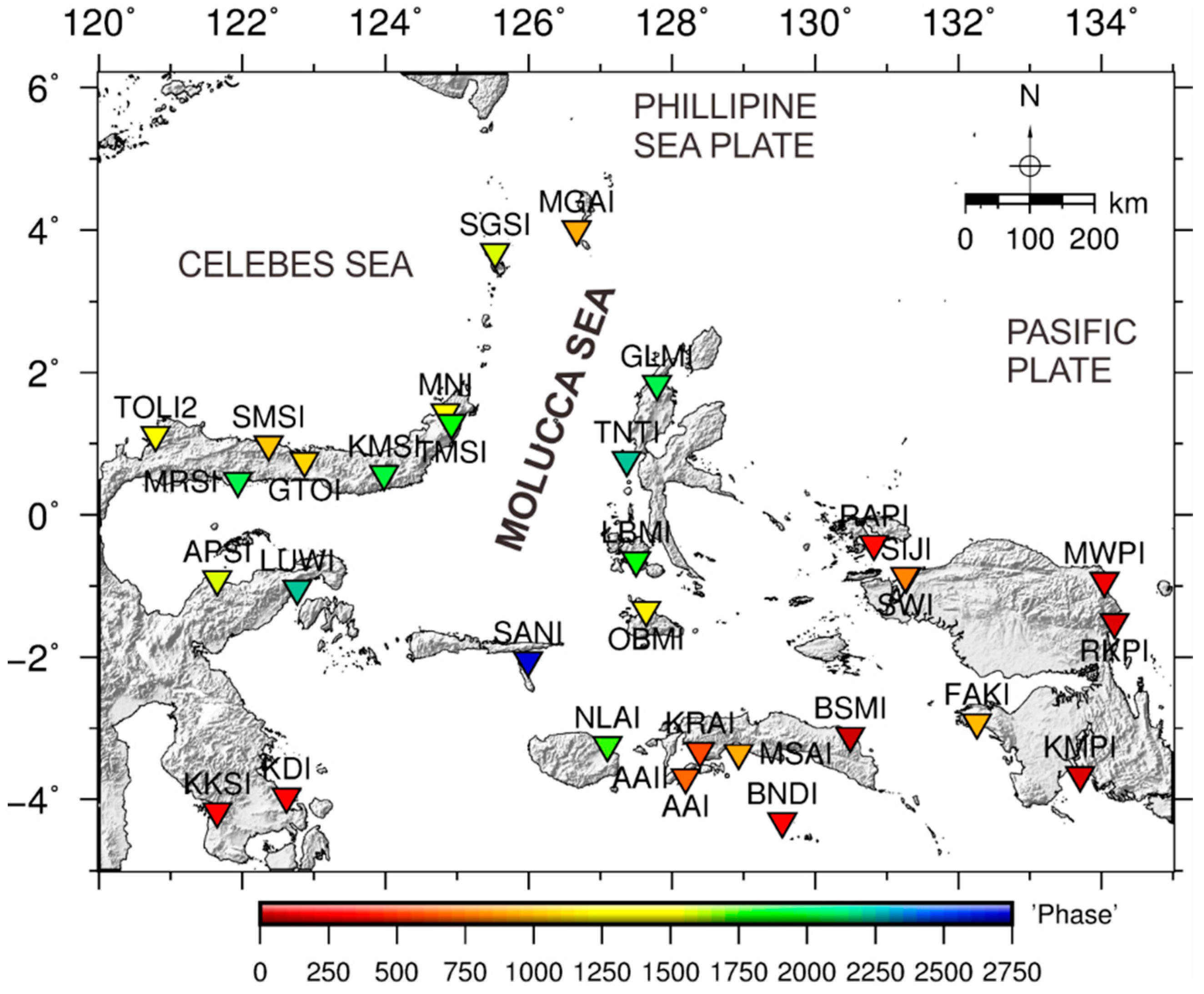
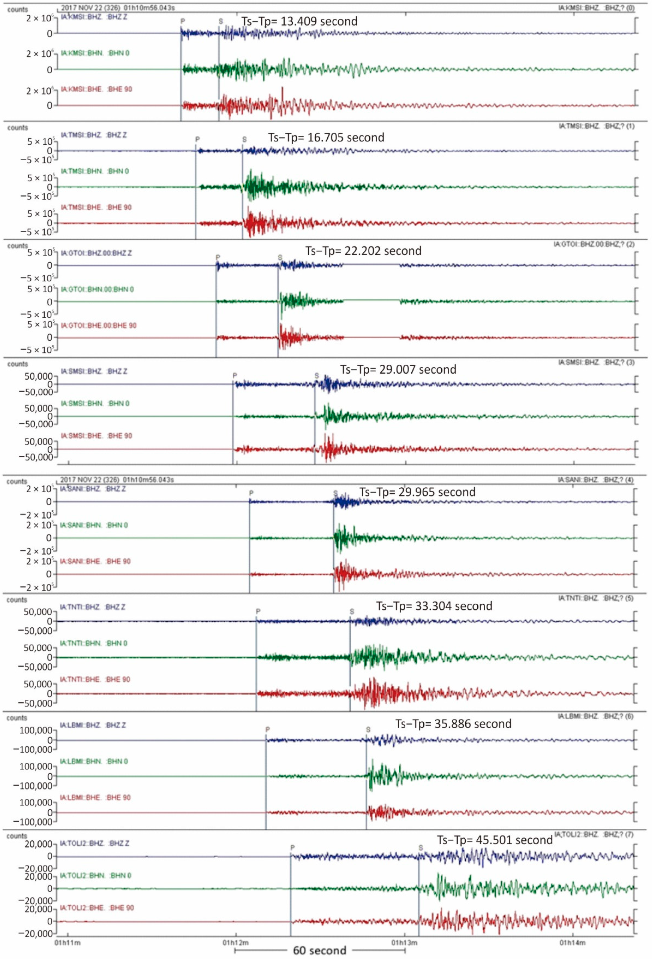
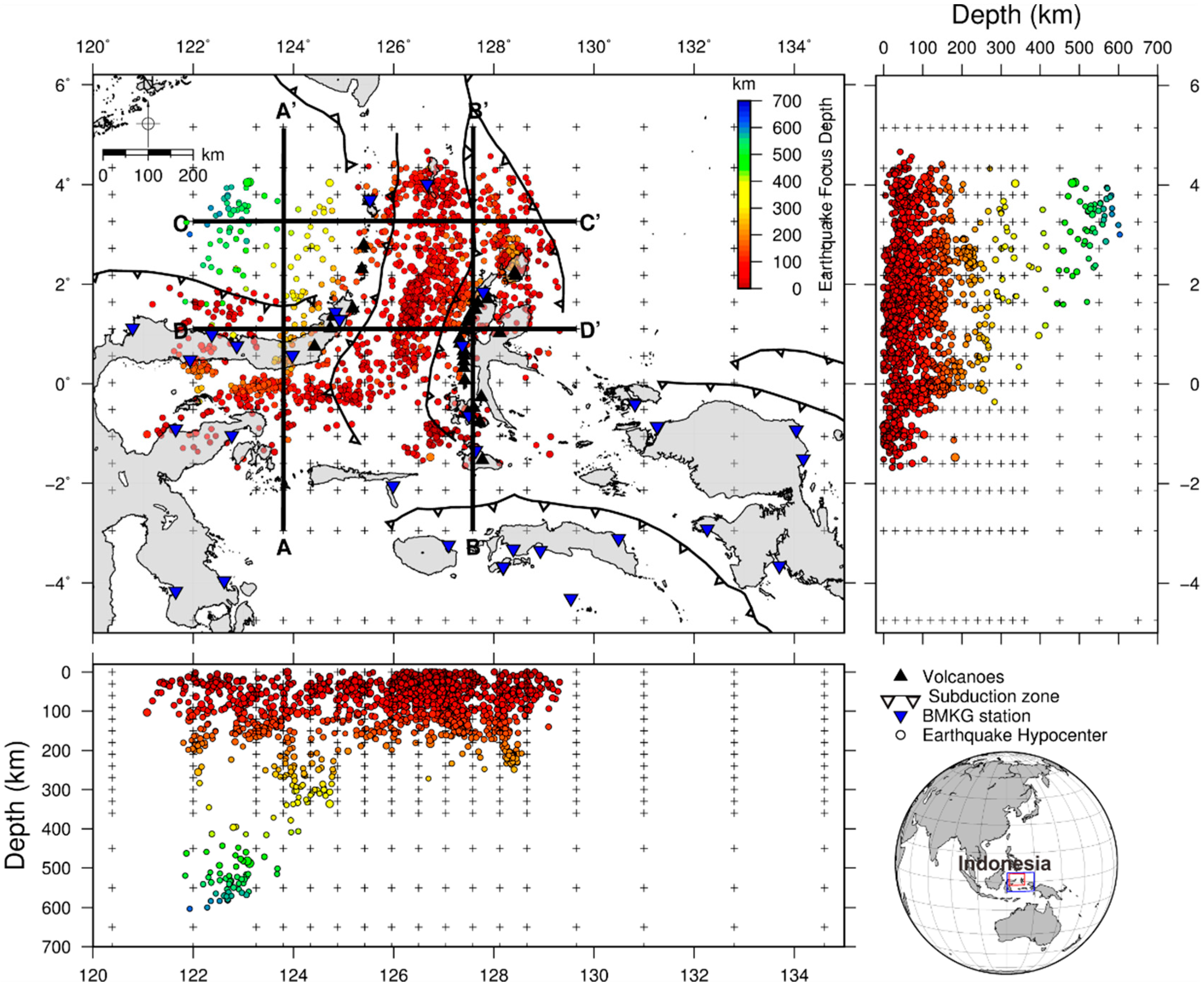
2.1. Data
2.2. Methods
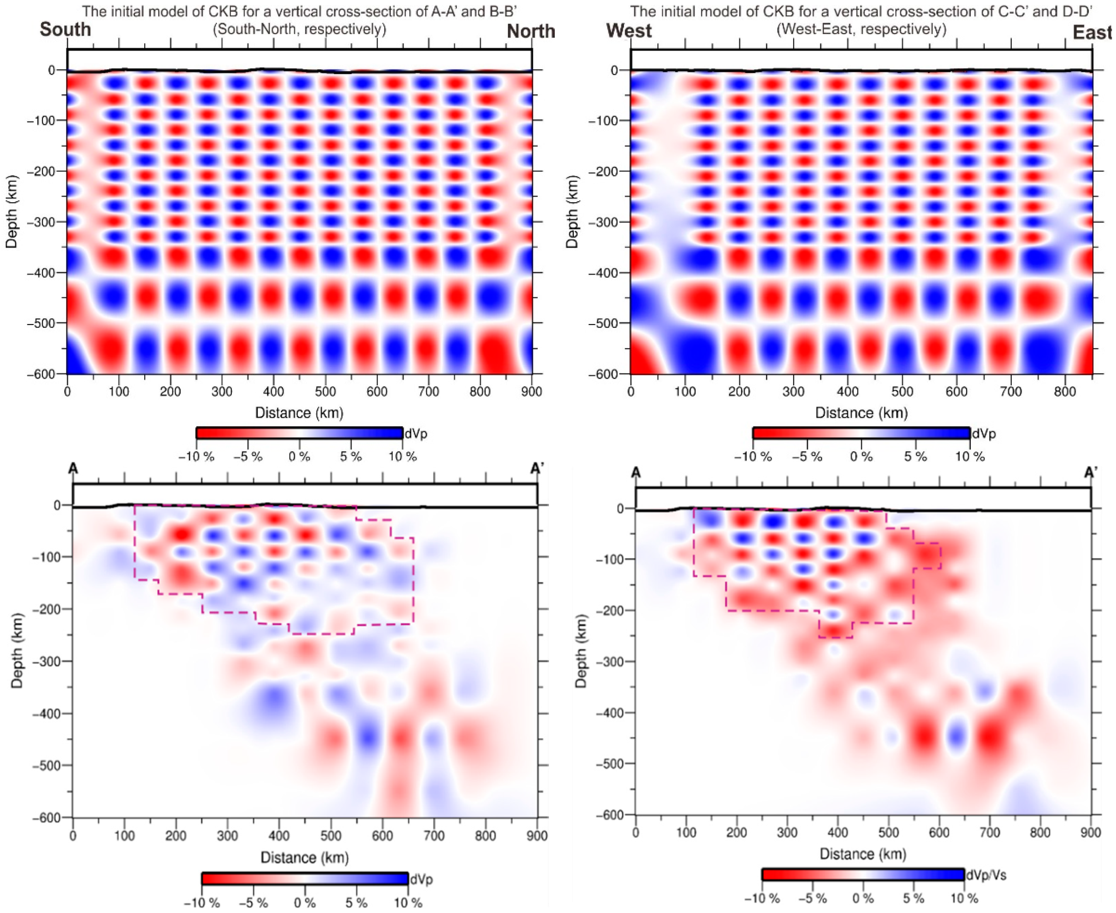
2.3. Resolution
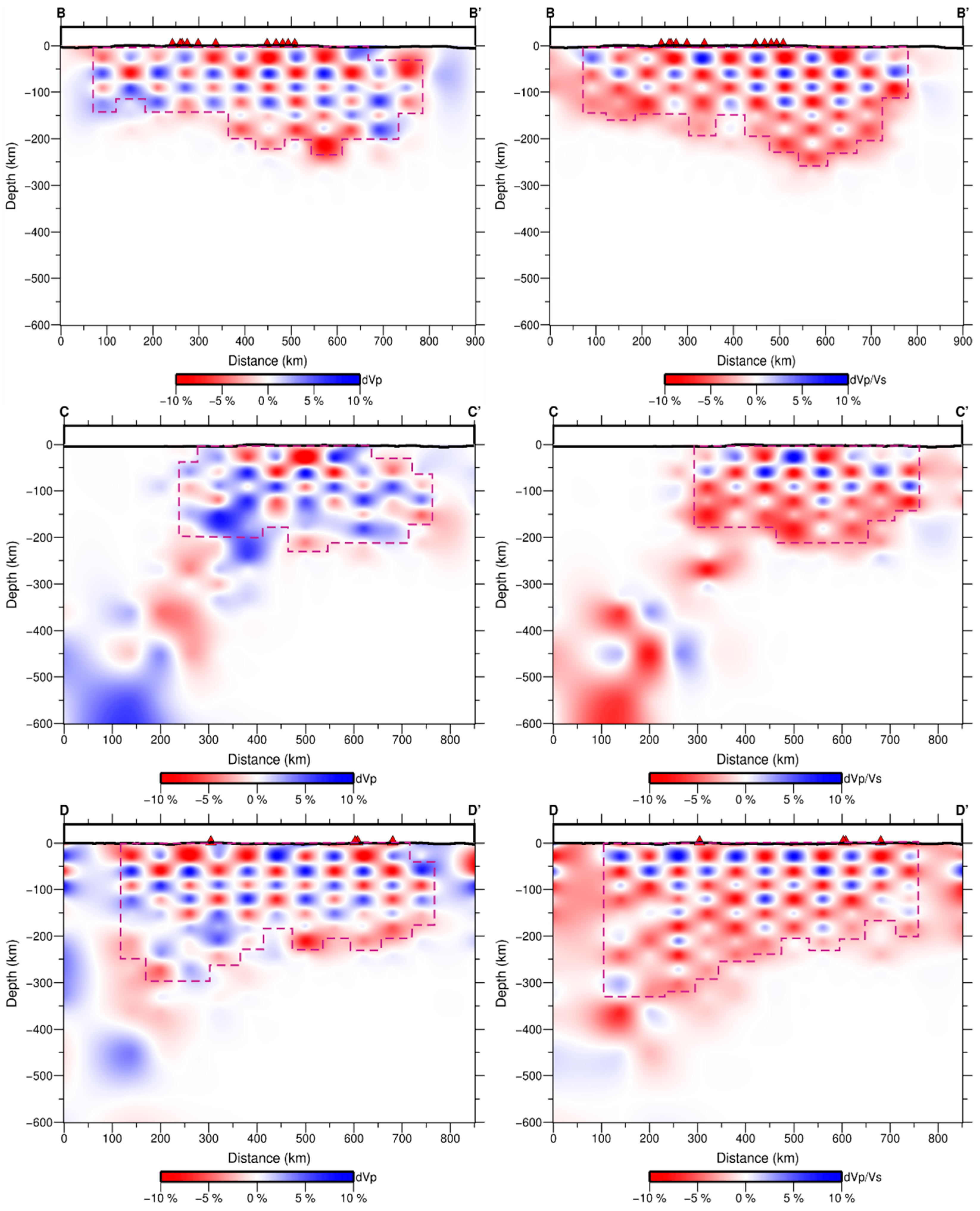
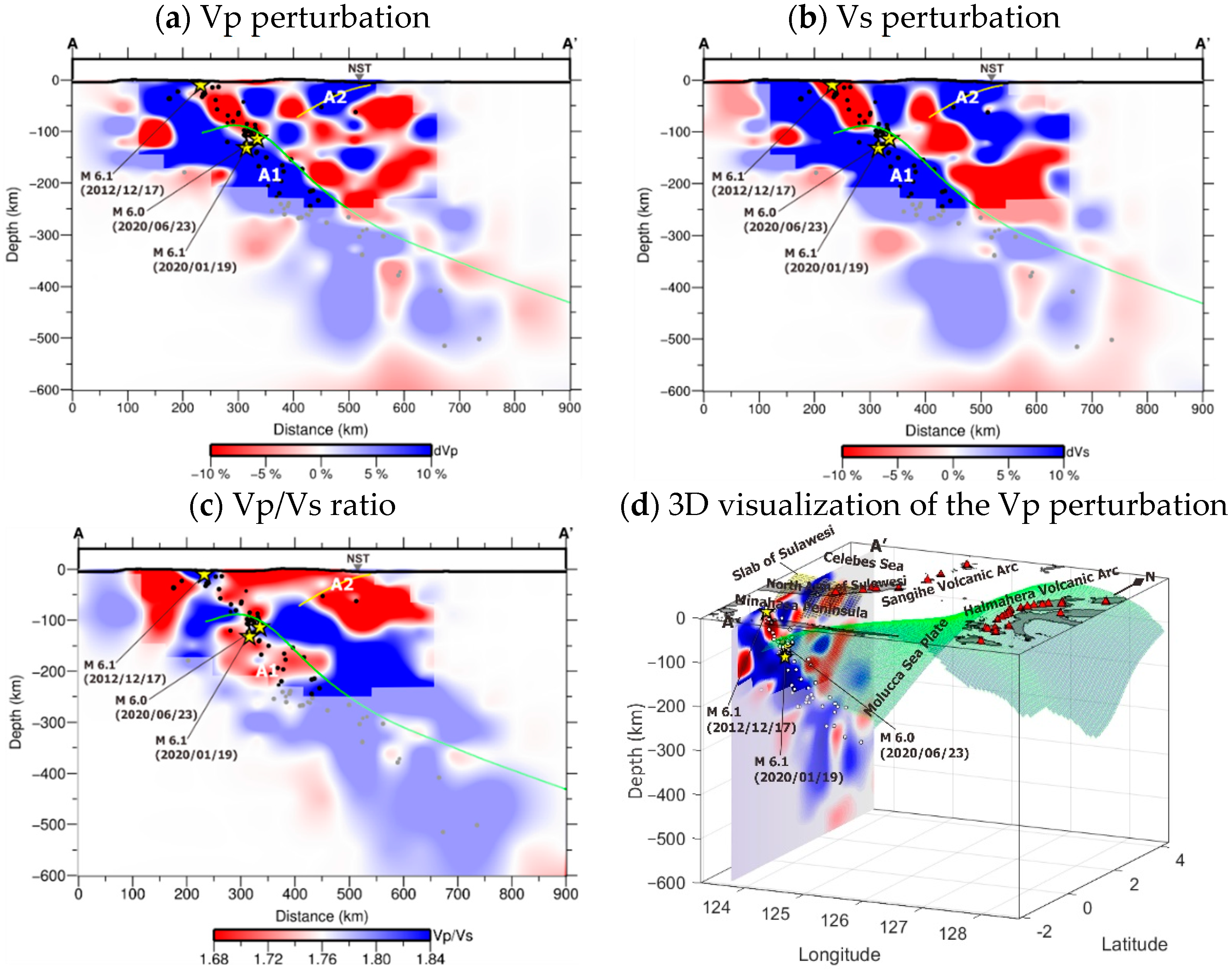
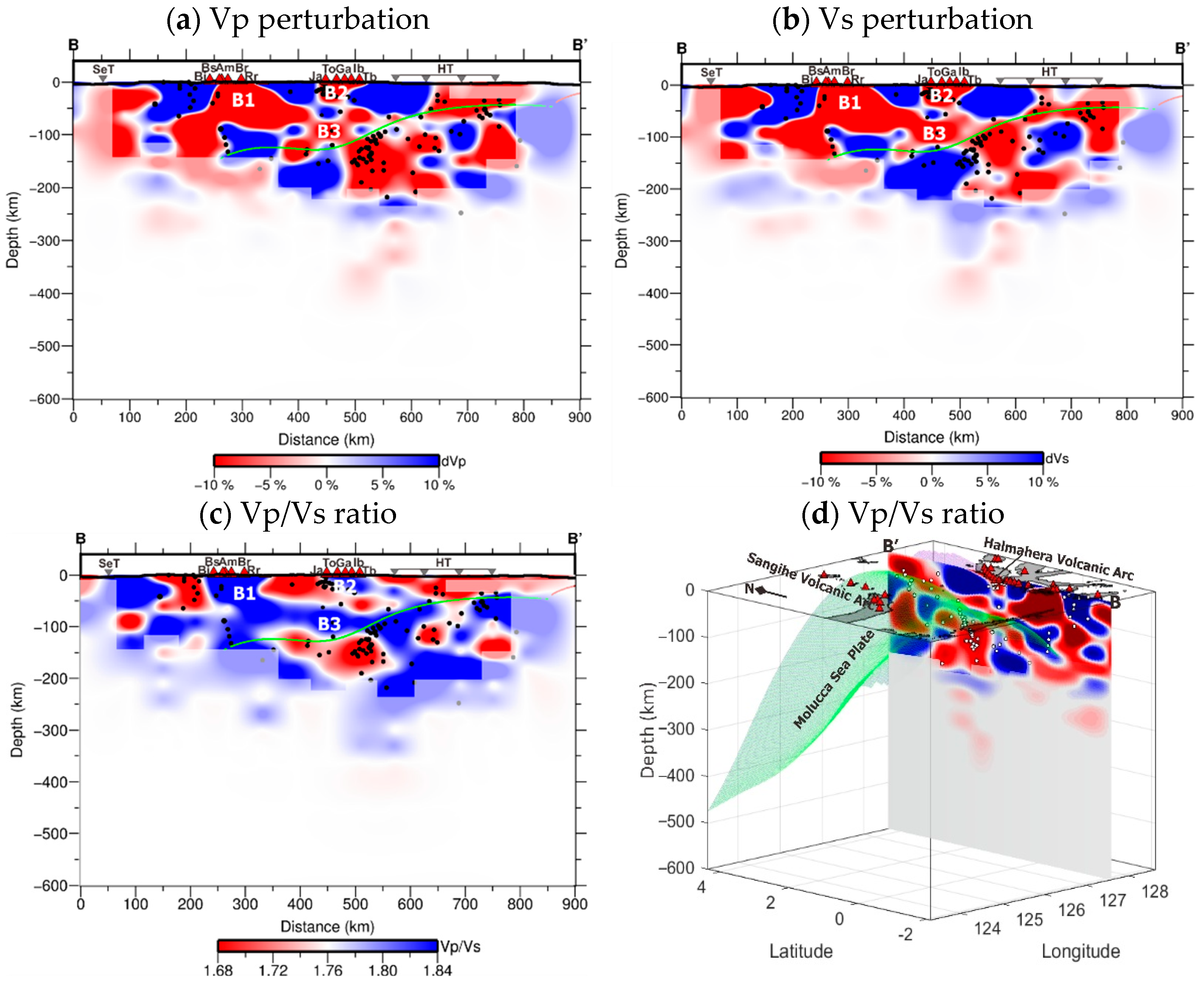
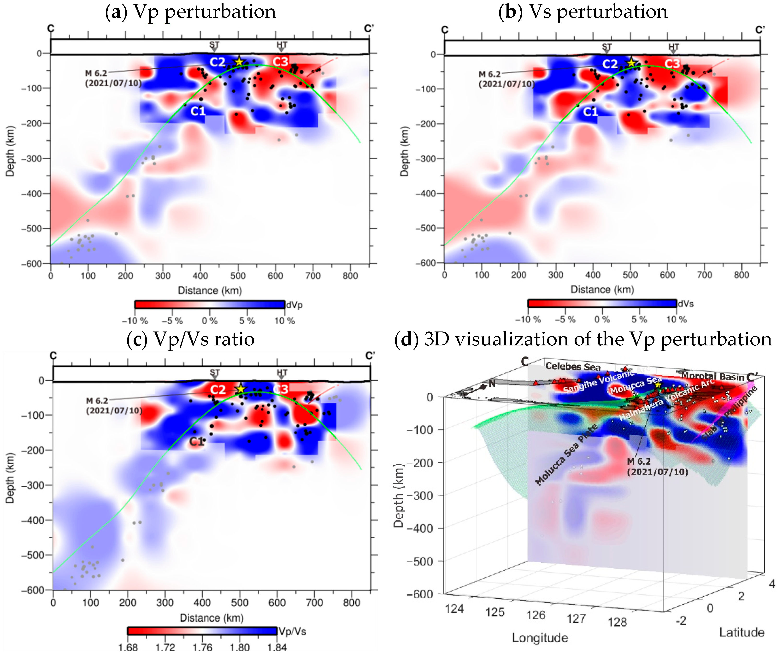
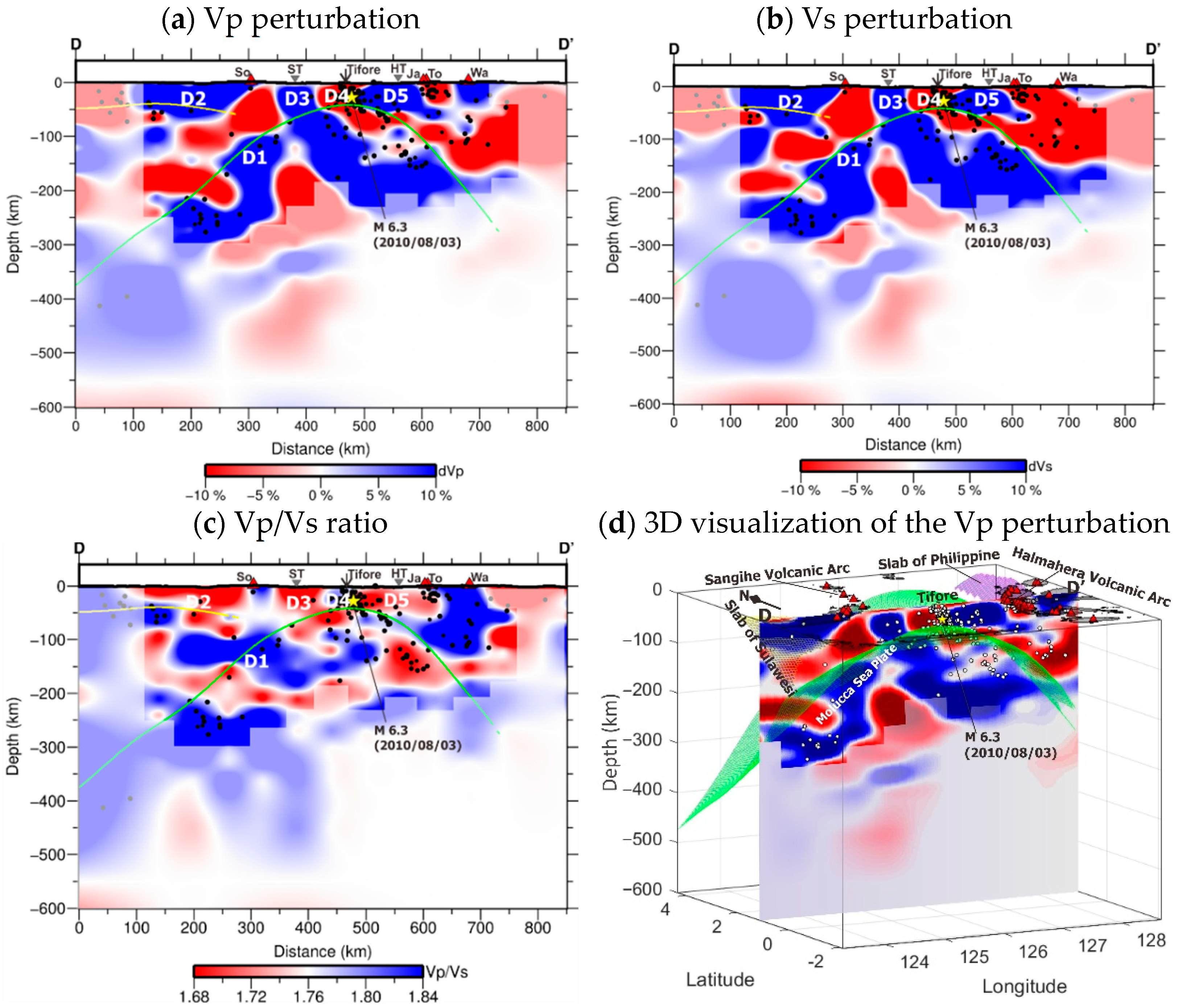
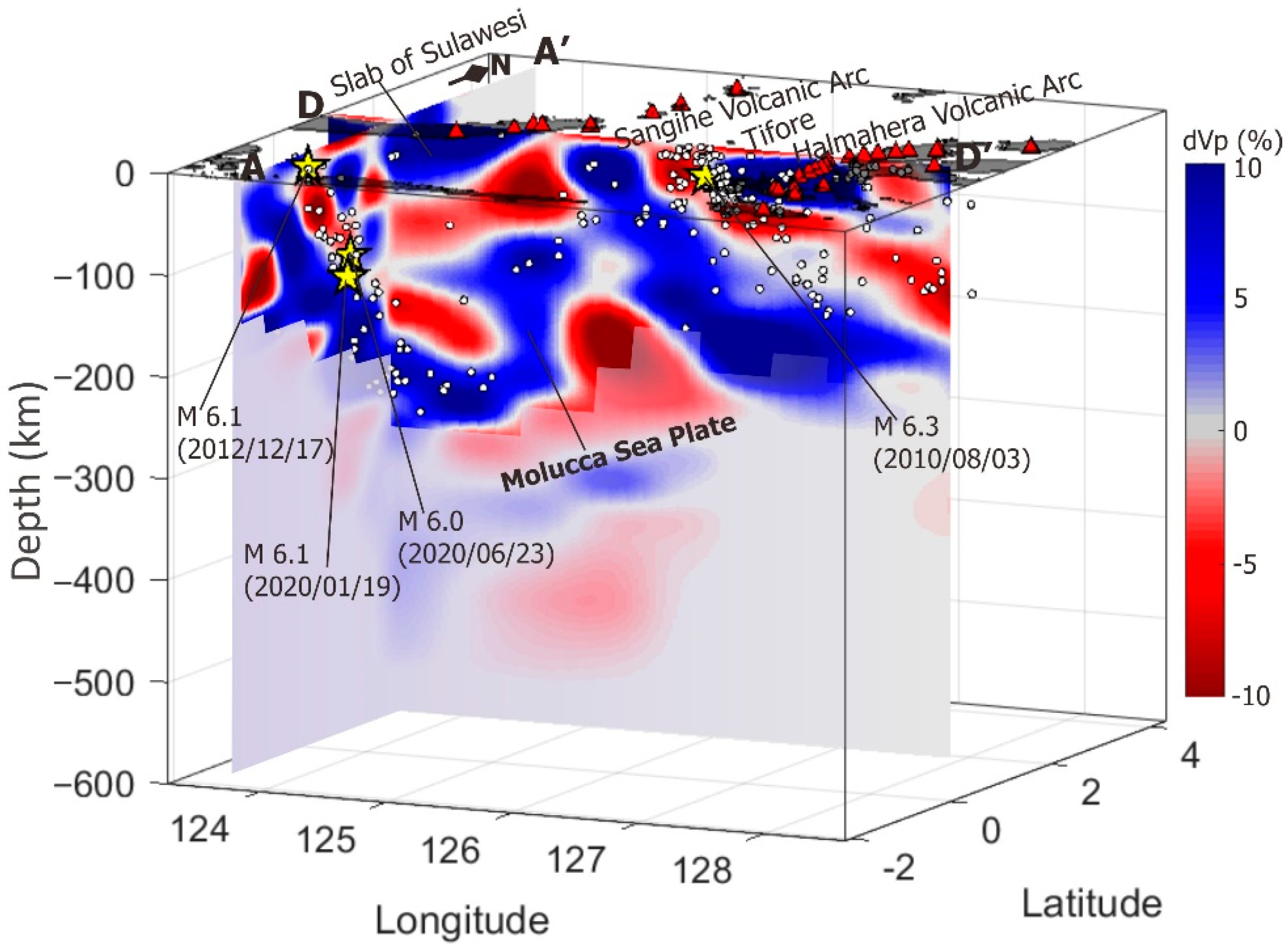
3. Results
4. Discussion
4.1. Subduction Zone Beneath Sulawesi’s North Arm
4.2. Subduction Zone Beneath Halmahera Volcano Arc
4.3. Double Subduction of the Molucca Sea Plate
5. Conclusions
Supplementary Materials
Author Contributions
Funding
Institutional Review Board Statement
Informed Consent Statement
Data Availability Statement
Acknowledgments
Conflicts of Interest
References
- Hall, R.; Nichols, G.; Ballantyne, P.; Charlton, T.; Ali, J. The Character and Significance of Basement Rocks of the Southern Molucca Sea Region. J. Southeast Asian Earth Sci. 1991, 6, 249–258. [Google Scholar] [CrossRef]
- McCaffrey, R.; Silver, E.A.; Raitt, R.W. Crustal Structure of the Molucca Sea Collision Zone, Indonesia. In The Tectonic and Geologic Evolution of Southeast Asian Seas and Islands; American Geophysical Union (AGU): Washington, DC, USA, 1980; pp. 161–177. [Google Scholar]
- Moore, G.F.; Kadarisman, D.; Evans, C.A.; Hawkins, J.W. Geology of the Talaud Islands, Molucca Sea Collision Zone, Northeast Indonesia. J. Struct. Geol. 1981, 3, 467–475. [Google Scholar] [CrossRef]
- Morris, J.D.; Jezek, P.A.; Hart, S.R.; Hill, J.B. The Halmahera Island Arc, Molucca Sea Collision Zone, Indonesia: A Geochemical Survey. In The Tectonic and Geologic Evolution of Southeast Asian Seas and Islands: Part 2; Geophysical Monograph Series; American Geophysical Union (AGU): Washington, DC, USA, 1983; Volume 27, pp. 373–387. [Google Scholar]
- Silver, E.A.; Moore, J.C. The Molucca Sea Collision Zone, Indonesia. J. Geophys. Res. Solid Earth 1978, 83, 1681–1691. [Google Scholar] [CrossRef]
- Hall, R.; Audley-Charles, M.G.; Banner, F.T.; Hidayat, S.; Tobing, S.L. Basement Rocks of the Halmahera Region, Eastern Indonesia: A Late Cretaceous–Early Tertiary Arc and Fore-Arc. J. Geol. Soc. London. 1988, 145, 65–84. [Google Scholar] [CrossRef]
- Hamilton, W.B. Tectonics of the Indonesian Region; U.S. Govt. Print. Off.: Washington, DC, USA, 1979. [Google Scholar]
- Hatherton, T.; Dickinson, W.R. The Relationship between Andesitic Volcanism and Seismicity in Indonesia, the Lesser Antilles, and Other Island Arcs. J. Geophys. Res. 1969, 74, 5301–5310. [Google Scholar] [CrossRef]
- Hafkenscheid, E.; Buiter, S.J.; Wortel, M.J.; Spakman, W.; Bijwaard, H. Modelling the Seismic Velocity Structure beneath Indonesia: A Comparison with Tomography. Tectonophysics 2001, 333, 35–46. [Google Scholar] [CrossRef]
- Cardwell, R.K.; Isaacks, B.L.; Karig, D.E. The Spatial Distribution of Earthquakes, Focal Mechanism Solutions, and Subducted Lithosphere in the Philippine and Northeastern Indonesian Islands. In The Tectonic and Geologic Evolution of Southeast Asian Seas and Islands; Geophys. Monogr., Ser.; Hayes, D.E., Ed.; AGU: Washington, DC, USA, 1980; Volume 23, pp. 1–35. [Google Scholar]
- McCaffrey, R. Lithospheric Deformation within the Molucca Sea Arc-Arc Collision: Evidence from Shallow and Intermediate Earthquake Activity. J. Geophys. Res. 1982, 87, 3663. [Google Scholar] [CrossRef]
- Hutchings, S.J.; Mooney, W.D. The Seismicity of Indonesia and Tectonic Implications. Geochem. Geophys. Geosyst. 2021, 22, e2021GC009812. [Google Scholar] [CrossRef]
- Hall, R. Plate Boundary Evolution in the Halmahera Region, Indonesia. Tectonophysics 1987, 144, 337–352. [Google Scholar] [CrossRef]
- Milsom, J.; Masson, D.; Nicols, G. Three Trench Endings in Eastern Indonesia. Mar. Geol. 1992, 104, 227–241. [Google Scholar] [CrossRef]
- Sufni Hakim, A.; Hall, R. Tertiary Volcanic Rocks from the Halmahera Arc, Eastern Indonesia. J. Southeast Asian Earth Sci. 1991, 6, 271–287. [Google Scholar] [CrossRef]
- Moore, G.F.; Silver, E.A. Collision Processes in the Northern Molucca Sea. In The Tectonic and Geologic Evolution of Southeast Asian Seas and Islands: Part 2; Geophys. Monogr., Ser.; Hayes, D.E., Ed.; AGU: Washington, DC, USA, 1983; Volume 27, pp. 360–372. [Google Scholar]
- Widiwijayanti, C.; Tiberi, C.; Deplus, C.; Diament, M.; Mikhailov, V.; Louat, R. Geodynamic Evolution of the Northern Molucca Sea Area (Eastern Indonesia) Constrained by 3-D Gravity Field Inversion. Tectonophysics 2004, 386, 203–222. [Google Scholar] [CrossRef]
- Widiwijayanti, C.; Mikhailov, V.; Diament, M.; Deplus, C.; Louat, R.; Tikhotsky, S.; Gvishiani, A. Structure and Evolution of the Molucca Sea Area: Constraints Based on Interpretation of a Combined Sea-Surface and Satellite Gravity Dataset. Earth Planet. Sci. Lett. 2003, 215, 135–150. [Google Scholar] [CrossRef]
- Hédervári, P.; Papp, Z. Seismicity Maps of the Indonesian Region. Tectonophysics 1981, 76, 131–148. [Google Scholar] [CrossRef]
- Hall, R.; Spakman, W. Mantle Structure and Tectonic History of SE Asia. Tectonophysics 2015, 658, 14–45. [Google Scholar] [CrossRef] [Green Version]
- Chen, P.F.; Chien, M.; Bina, C.R.; Yen, H.Y.; Antonio Olavere, E. Evidence of an East-Dipping Slab beneath the Southern End of the Philippine Trench (1°N–6°N) as Revealed by ISC-EHB. J. Asian Earth Sci. X 2020, 4, 100034. [Google Scholar] [CrossRef]
- Puspito, N.T.; Yamanaka, Y.; Miyatake, T.; Shimazaki, K.; Hirahara, K. Three-Dimensional P-Wave Velocity Structure beneath the Indonesian Region. Tectonophysics 1993, 220, 175–192. [Google Scholar] [CrossRef]
- Widiyantoro, S.; Hilst, R. Mantle Structure beneath Indonesia Inferred from High-Resolution Tomographic Imaging. Geophys. J. Int. 1997, 130, 167–182. [Google Scholar] [CrossRef] [Green Version]
- Widiyantoro, S. Complex Morphology of Subducted Lithosphere in the Mantle below the Molucca Collision Zone from Non-Linear Seismic Tomography. ITB J. Eng. Sci. 2003, 35, 1–10. [Google Scholar] [CrossRef] [Green Version]
- Huang, Z.; Zhao, D.; Wang, L. P Wave Tomography and Anisotropy beneath Southeast Asia: Insight into Mantle Dynamics. J. Geophys. Res. Solid Earth 2015, 120, 5154–5174. [Google Scholar] [CrossRef]
- Zhang, Q.; Guo, F.; Zhao, L.; Wu, Y. Geodynamics of Divergent Double Subduction: 3-D Numerical Modeling of a Cenozoic Example in the Molucca Sea Region, Indonesia. J. Geophys. Res. Solid Earth 2017, 122, 3977–3998. [Google Scholar] [CrossRef]
- Fan, J.; Zhao, D. Evolution of the Southern Segment of the Philippine Trench: Constraints from Seismic Tomography. Geochem. Geophys. Geosyst. 2018, 19, 4612–4627. [Google Scholar] [CrossRef]
- Fan, J.; Zhao, D. P-Wave Anisotropic Tomography of the Central and Southern Philippines. Phys. Earth Planet. Inter. 2019, 286, 154–164. [Google Scholar] [CrossRef]
- Zenonos, A.; De Siena, L.; Widiyantoro, S.; Rawlinson, N. P and S Wave Travel Time Tomography of the SE Asia-Australia Collision Zone. Phys. Earth Planet. Inter. 2019, 293, 106267. [Google Scholar] [CrossRef]
- Zenonos, A.; De Siena, L.; Widiyantoro, S.; Rawlinson, N. Direct Inversion of S-P Differential Arrival Times for Ratio in SE Asia. J. Geophys. Res. Solid Earth 2020, 125, e2019JB019152. [Google Scholar] [CrossRef]
- Cao, L.; He, X.; Zhao, L.; Lü, C.; Hao, T.; Zhao, M.; Qiu, X. Mantle Flow Patterns Beneath the Junction of Multiple Subduction Systems Between the Pacific and Tethys Domains, SE Asia: Constraints From SKS-Wave Splitting Measurements. Geochem. Geophys. Geosyst. 2021, 22, e2021GC009700. [Google Scholar] [CrossRef]
- Lomax, A.; Michelini, A. Mwpd: A Duration-Amplitude Procedure for Rapid Determination of Earthquake Magnitude and Tsunamigenic Potential from P Waveforms. Geophys. J. Int. 2009, 176, 200–214. [Google Scholar] [CrossRef] [Green Version]
- Lomax, A.; Virieux, J.; Volant, P.; Berge-Thierry, C. Probabilistic Earthquake Location in 3D and Layered Models; Springer: Dordrecht, The Netherlands, 2000; pp. 101–134. [Google Scholar]
- Tarantola, A.; Valette, B. Inverse Problems = Quest for Information. J. Geophys. 1982, 50, 159–170. [Google Scholar]
- Moser, T.J.; van Eck, T.; Nolet, G. Hypocenter Determination in Strongly Heterogeneous Earth Models Using the Shortest Path Method. J. Geophys. Res. 1992, 97, 6563. [Google Scholar] [CrossRef]
- Wittlinger, G.; Herquel, G.; Nakache, T. Earthquake Location in Strongly Heterogeneous Media. Geophys. J. Int. 1993, 115, 759–777. [Google Scholar] [CrossRef] [Green Version]
- Kennett, B.L.N.; Engdahl, E.R. Traveltimes for Global Earthquake Location and Phase Identification. Geophys. J. Int. 1991, 105, 429–465. [Google Scholar] [CrossRef]
- Kennett, B.L.N.; Engdahl, E.R.; Buland, R. Constraints on Seismic Velocities in the Earth from Traveltimes. Geophys. J. Int. 1995, 122, 108–124. [Google Scholar] [CrossRef] [Green Version]
- Evans, J.R.; Eberhart-Phillips, D.; Thurber, C.H. User’s Manual for SIMULPS12 for Imaging vp and vp/vs; a Derivative of the “Thurber” Tomographic Inversion SIMUL3 for Local Earthquakes and Explosions; Open-File Rep. Open-File Report 94-431; U.S. Geological Survey: Reston, VI, USA, 1994; p. 101. [Google Scholar] [CrossRef] [Green Version]
- Um, J.; Thurber, C. A Fast Algorithm for Two-Point Seismic Ray Tracing. Bull. Seismol. Soc. Am. 1987, 77, 972–986. [Google Scholar] [CrossRef]
- Eberhart-Phillips, D. Three-Dimensional Velocity Structure in Northern California Coast Ranges from Inversion of Local Earthquake Arrival Times. Bull. Seismol. Soc. Am. 1986, 76, 1025–1052. [Google Scholar] [CrossRef]
- Thurber, C.H. Local Earthquake Tomography: Velocities and Vp/Vs-Theory; Chapman and Hall: London, UK, 1993; ISBN 0412371901. [Google Scholar]
- Nugraha, A. Tomografi Seismik, 1st ed.; ITB Press: Bandung, Indonesia, 2017; ISBN 978-602-5417-48-1. [Google Scholar]
- Rawlinson, N.; Sambridge, M. Seismic Traveltime Tomography of The Crust and Lithosphere; Elsevier: Amsterdam, The Netherlands, 2003; pp. 81–198. [Google Scholar]
- Hayes, G.P.; Moore, G.L.; Portner, D.E.; Hearne, M.; Flamme, H.; Furtney, M.; Smoczyk, G.M. Slab2, a Comprehensive Subduction Zone Geometry Model. Science 2018, 362, 58–61. [Google Scholar] [CrossRef] [PubMed]
- Zhao, D. Multiscale Seismic Tomography; Springer: Japan, Tokyo, 2015; ISBN 978-4-431-55359-5. [Google Scholar]
- Zhao, D.; Yamashita, K.; Toyokuni, G. Tomography of the 2016 Kumamoto Earthquake Area and the Beppu-Shimabara Graben. Sci. Rep. 2018, 8, 15488. [Google Scholar] [CrossRef] [Green Version]
- Hasegawa, A.; Umino, N.; Takagi, A. Double-Planed Structure of the Deep Seismic Zone in the Northeastern Japan Arc. Tectonophysics 1978, 47, 43–58. [Google Scholar] [CrossRef]
- Hasegawa, A.; Umino, N.; Takagi, A. Double-Planed Deep Seismic Zone and Upper-Mantle Structure in the Northeastern Japan Arc. Geophys. J. Int. 1978, 54, 281–296. [Google Scholar] [CrossRef] [Green Version]
- Chou, H.-C.; Kuo, B.-Y.; Chiao, L.-Y.; Zhao, D.; Hung, S.-H. Tomography of the Westernmost Ryukyu Subduction Zone and the Serpentinization of the Fore-Arc Mantle. J. Geophys. Res. Solid Earth 2009, 114, 12301. [Google Scholar] [CrossRef] [Green Version]
- Hall, R.; Ali, J.R.; Anderson, C.D.; Hall, R.; Ali, J.R.; Anderson, C.D. Cenozoic Motion of the Philippine Sea Plate: Palaeomagnetic Evidence from Eastern Indonesia. Tecto 1995, 14, 1117–1132. [Google Scholar] [CrossRef]
- Kim, K.-H.; Chiu, J.-M.; Pujol, J.; Chen, K.-C.; Huang, B.-S.; Yeh, Y.-H.; Shen, P. Three-Dimensional VP and VS Structural Models Associated with the Active Subduction and Collision Tectonics in the Taiwan Region. Geophys. J. Int. 2005, 162, 204–220. [Google Scholar] [CrossRef] [Green Version]
- Zhao, D. Multiscale Seismic Tomography and Mantle Dynamics. Gondwana Res. 2009, 15, 297–323. [Google Scholar] [CrossRef]
- Siebert, L.; Simkin, T.; Kimberly, P. Volcanoes of the World; Smithsonian Institution: Washington, DC, USA, 2010; ISBN 0520268776. [Google Scholar]
- Nugraha, A.D.; Shiddiqi, H.A.; Widiyantoro, S.; Puspito, N.T.; Triyoso, W.; Wiyono, S.; Daryono; Wandono; Rosalia, S. Hypocenter Relocation of Earthquake Swarm in West Halmahera, North Molucca Region, Indonesia by Using Double-Difference Method and 3D Seismic Velocity Structure. IOP Conf. Ser. Earth Environ. Sci. 2017, 62, 012053. [Google Scholar] [CrossRef] [Green Version]
- Nugraha, A.D.; Supendi, P.; Widiyantoro, S.; Daryono; Wiyono, S. Hypocenter Relocation of Earthquake Swarm around Jailolo Volcano, North Molucca, Indonesia Using the BMKG Network Data: Time Periods of 27 September–10 October 2017. AIP Conf. Proc. 2018, 1987, 020093. [Google Scholar] [CrossRef]
- Nakajima, J.; Matsuzawa, T.; Hasegawa, A.; Zhao, D. Three-Dimensional Structure of Vp, Vs, and Vp/Vs beneath Northeastern Japan: Implications for Arc Magmatism and Fluids. J. Geophys. Res. Solid Earth 2001, 106, 21843–21857. [Google Scholar] [CrossRef]
- Lin, J.Y.; Hsu, S.K.; Sibuet, J.C. Melting Features along the Ryukyu Slab Tear, beneath the Southwestern Okinawa Trough. Geophys. Res. Lett. 2004, 31, 20862. [Google Scholar] [CrossRef] [Green Version]
- Maruyama, S.; Hasegawa, A.; Santosh, M.; Kogiso, T.; Omori, S.; Nakamura, H.; Kawai, K.; Zhao, D. The Dynamics of Big Mantle Wedge, Magma Factory, and Metamorphic-Metasomatic Factory in Subduction Zones. Gondwana Res. 2009, 16, 414–430. [Google Scholar] [CrossRef]
- Amaru, M.L. Global Travel Time Tomography with 3-D Reference Models. Geol. Ultraiectina 2007, 274, 81–88. [Google Scholar]
- Wagner, L.S.; Anderson, M.L.; Jackson, J.M.; Beck, S.L.; Zandt, G. Seismic Evidence for Orthopyroxene Enrichment in the Continental Lithosphere. Geology 2008, 36, 935–938. [Google Scholar] [CrossRef] [Green Version]
- Zheng, Y.; Lay, T. Low Vp/Vs Ratios in the Crust and Upper Mantle beneath the Sea of Okhotsk Inferred from Teleseismic PMP, SMP, and SMS Underside Reflections from the Moho. J. Geophys. Res. Solid Earth 2006, 111, 1305. [Google Scholar] [CrossRef] [Green Version]
- Bariş, S.; Nakajima, J.; Hasegawa, A.; Honkura, Y.; Ito, A.; Balamir, S. Three-Dimensional Structure of Vp, Vs and Vp/Vs in the Upper Crust of the Marmara Region, NW Turkey. Earth Planets Sp. 2005, 57, 1019–1038. [Google Scholar] [CrossRef]


Publisher’s Note: MDPI stays neutral with regard to jurisdictional claims in published maps and institutional affiliations. |
© 2022 by the authors. Licensee MDPI, Basel, Switzerland. This article is an open access article distributed under the terms and conditions of the Creative Commons Attribution (CC BY) license (https://creativecommons.org/licenses/by/4.0/).
Share and Cite
Rachman, G.; Santosa, B.J.; Nugraha, A.D.; Rohadi, S.; Rosalia, S.; Zulfakriza, Z.; Sungkono, S.; Sahara, D.P.; Muttaqy, F.; Supendi, P.; et al. Seismic Structure Beneath the Molucca Sea Collision Zone from Travel Time Tomography Based on Local and Regional BMKG Networks. Appl. Sci. 2022, 12, 10520. https://0-doi-org.brum.beds.ac.uk/10.3390/app122010520
Rachman G, Santosa BJ, Nugraha AD, Rohadi S, Rosalia S, Zulfakriza Z, Sungkono S, Sahara DP, Muttaqy F, Supendi P, et al. Seismic Structure Beneath the Molucca Sea Collision Zone from Travel Time Tomography Based on Local and Regional BMKG Networks. Applied Sciences. 2022; 12(20):10520. https://0-doi-org.brum.beds.ac.uk/10.3390/app122010520
Chicago/Turabian StyleRachman, Gazali, Bagus Jaya Santosa, Andri Dian Nugraha, Supriyanto Rohadi, Shindy Rosalia, Zulfakriza Zulfakriza, Sungkono Sungkono, David P. Sahara, Faiz Muttaqy, Pepen Supendi, and et al. 2022. "Seismic Structure Beneath the Molucca Sea Collision Zone from Travel Time Tomography Based on Local and Regional BMKG Networks" Applied Sciences 12, no. 20: 10520. https://0-doi-org.brum.beds.ac.uk/10.3390/app122010520