Article

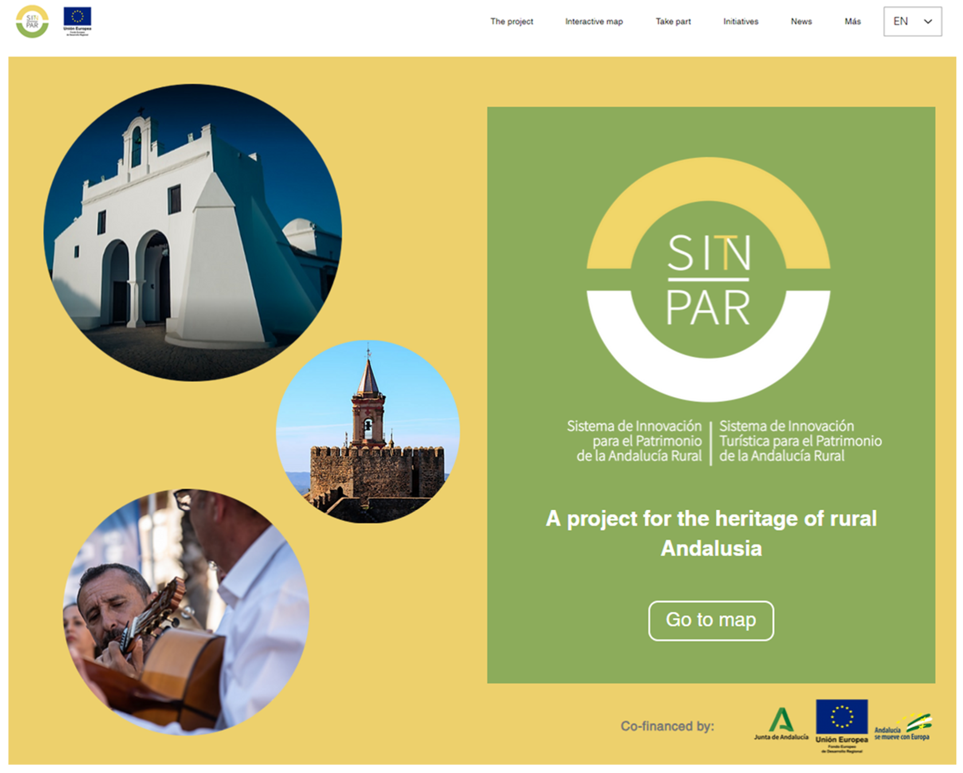
Collaborative Mapping as a Tool for Citizen Participation: A Case of Cultural Heritage Management in Rural Areas

by
Blanca Del Espino Hidalgo
*,† and
Virginia Rodríguez Díaz
Instituto Andaluz del Patrimonio Histórico, 41092 Sevilla, Spain
*
Author to whom correspondence should be addressed.
Current Address: Department of Urban and Land Planning, Higher Technical School of Architecture, University of Seville, 41012 Sevilla, Spain.
Submission received: 14 September 2023 / Revised: 16 October 2023 / Accepted: 17 October 2023 / Published: 24 October 2023

Abstract

:
The role of citizens in the construction of knowledge is undergoing a clear transformation from a passive position, as mere observers and/or receivers, to an increasingly participatory role. This issue, which is directly related to governance policies as well as to the ICT revolution, can be seen in the field of cultural heritage and particularly architectural heritage management. The present paper aims to generate methodologies to involve citizens as active agents who must be involved in a real way in decision making concerning the protection and enhancement of cultural heritage. The results present the creation of a rural heritage interactive cartographic viewer as a collaborative mapping tool. The conclusions drawn position the citizens of rural, dispersed, or vulnerable areas as informers and builders of knowledge about the cultural and architectural heritage of their environment in terms of citizen science. At the same time, it strengthens the development of innovation strategies in the intervention, management, and communication of the existing dispersed heritage in rural areas.

1. Introduction

The role of citizens in the construction of knowledge is undergoing an evident transformation from a passive position, as mere observers and/or receivers, to an increasingly participatory position. This issue, which is directly related to governance policies and the Information and Communication Technologies (ICT) revolution, extends to the field of cultural heritage management, with a particular impact on the analysis and communication of architectural heritage. Thus, management models that include citizens as active agents are becoming more and more common [1,2,3] and there is a growing appreciation of the design of mechanisms and tools that allow the knowledge, and therefore the valuation, of cultural heritage in a collective way [4,5,6].
There is thus an increase in the importance of the need for the co-production of knowledge about heritage by the competent administration in the field of cultural heritage protection, with the development of projects and initiatives that are identified as citizen science (CS) [7]. These initiatives seek to generate “scientific production based on the conscious and voluntary participation of thousands of citizens who generate large amounts of data” [8] (p. 12), with or without previous expertise and often with the help of ICTs, which has given rise to the subcategory of digital citizen science (known by the acronym eCS). Its very conception has allowed it to become an increasingly common working method in the management of heritage resources [9] such as, for example, assets that are very difficult to address by one or a group of researchers, such as underwater cultural heritage [10], or in initiatives linked to the territorial management of built and architectural heritage, as in the case of the fight against the consequences of climate change in coastal heritage areas [11].
Public bodies are also working in this direction, inviting citizens to voluntarily and massively improve their knowledge of the cultural heritage of their territorial areas. In this context, citizen science projects such as those promoted by the Andalusian Historical Heritage Institute (IAPH) have made it possible to evaluate the suitability of institutional and citizen collaboration in the production and evaluation of information on assets of cultural interest. These are the cases of the Atlas of the Intangible Heritage of Andalusia and the Network of Informant Agents of the Cultural Heritage of Andalusia [12,13], the Register of Landscapes of Cultural Interest in Andalusia [14], or the Open Laboratory of the Cultural Heritage of Andalusia [15]. These projects develop participatory tools and techniques that improve and enrich the processes of documentation of cultural heritage assets as well as the availability of open data through consultation in the Digital Guide to the Cultural Heritage of Andalusia [16]. These initiatives present the digital humanities as technological tools suitable for active citizen participation, whose documentary usefulness is based on the incorporation of the vision that various agents have of their cultural heritage.
Among the tools described are web mapping applications that enable user interaction with geodata on the web, “thus increasing interoperability and the possibility of combining data and services [...] through the use of standards” [17] (p. 777). This is why they are presented as useful mechanisms for collaboration between science, administration, and citizens, driven by the implementation of Spatial Data Infrastructures (SDIs) that focus on Geographic Information Technologies (GIT) for society [18].
In this technological context, the Andalusian public administration is developing web mapping applications that allow the active participation of citizens in territorial decision-making processes, turning users into potential editors of spatial information collectively. Therefore, among the many geo-visors implemented in recent decades, those that allow two-way and even multidirectional interaction with the user stand out, which are more common in areas such as environmental management, risk management, or urban planning: Gis and Coast [19], The Citizen Drought Observatory [20], Know your sources [21], or Seville, your city [22].
From the management of Andalusian cultural heritage, there are some web mapping initiatives based on the dissemination of spatial information: the Digital Guide to Cultural Heritage of Andalusia [23], the cartographic viewer for consulting protected assets of the General Catalogue of the Historical Heritage of Andalusia [24], or the IAPH node of the Spatial Data Infrastructure of Andalusia [25]. However, few developments allow for bidirectional interaction with the user.
The theoretical–methodological context described above situates the Andalusian Rural Heritage Viewer, the resource on which this work focuses, as the result of the design and implementation of an interactive mapping tool, which forms part of the strategies for innovation in the intervention, management, and communication of the dispersed cultural heritage existing in Andalusian rural areas. In this way, the computer tool designed resolves the need for greater citizen participation in decision making, taking into account a double objective (1) to highlight the importance that the cultural heritage of the immediate environment has for citizens, especially in rural areas, through its perception and valuation, and (2) to build a web mapping tool that, through the dissemination and/or collection of information, places citizens as protagonists in the identification of their cultural heritage.
Therefore, the technological proposal presented here combines the importance of acquiring and maintaining updated information on dispersed cultural heritage (assets, agents, territorial management systems, etc.) with the identification of initiatives that enable the incorporation of cultural heritage as a territorial resource in the design of sustainable development actions for the areas in which it is located. In this line of argument, we identify citizens as active agents who must participate in a meaningful way in the decision-making processes related to the protection and valuation of assets of cultural interest, but also as informers and builders of knowledge about cultural heritage, especially in their immediate surroundings. This relationship between citizen and lived or perceived heritage acquires a special significance in rural areas, with clear demographic and economic problems, in the face of “high rates of conservation of their heritage” [26] (p. 2).

2. Materials and Methods

The theoretical–methodological context described above justifies the design and implementation of a computer tool that allows for greater citizen participation in the tasks of identification and documentation of cultural heritage, taking into account the following specific objectives: (1) to document Andalusian cultural heritage in vulnerable areas with processes in which the citizen is the editor of information; (2) to provide the IAPH with an additional source of information to the usual ones in the production of digital thematic cartography of the architectural and intangible heritage of Andalusia; (3) to facilitate the visualisation on the web of programmes, actions, and proposals for intervention in the territory through the sustainable management of cultural heritage for the different agents; (4) to reuse the information in cultural heritage protection tasks in the field of application; and (5) to test the usefulness of participatory methodologies and tools in the management of built and immaterial cultural heritage in rural areas.
In turn, the geo-viewer forms part of a context of proactive management, together with the design of other strategies for innovation in the intervention, management, and communication of the dispersed heritage existing in the rural areas of Andalusia [27].

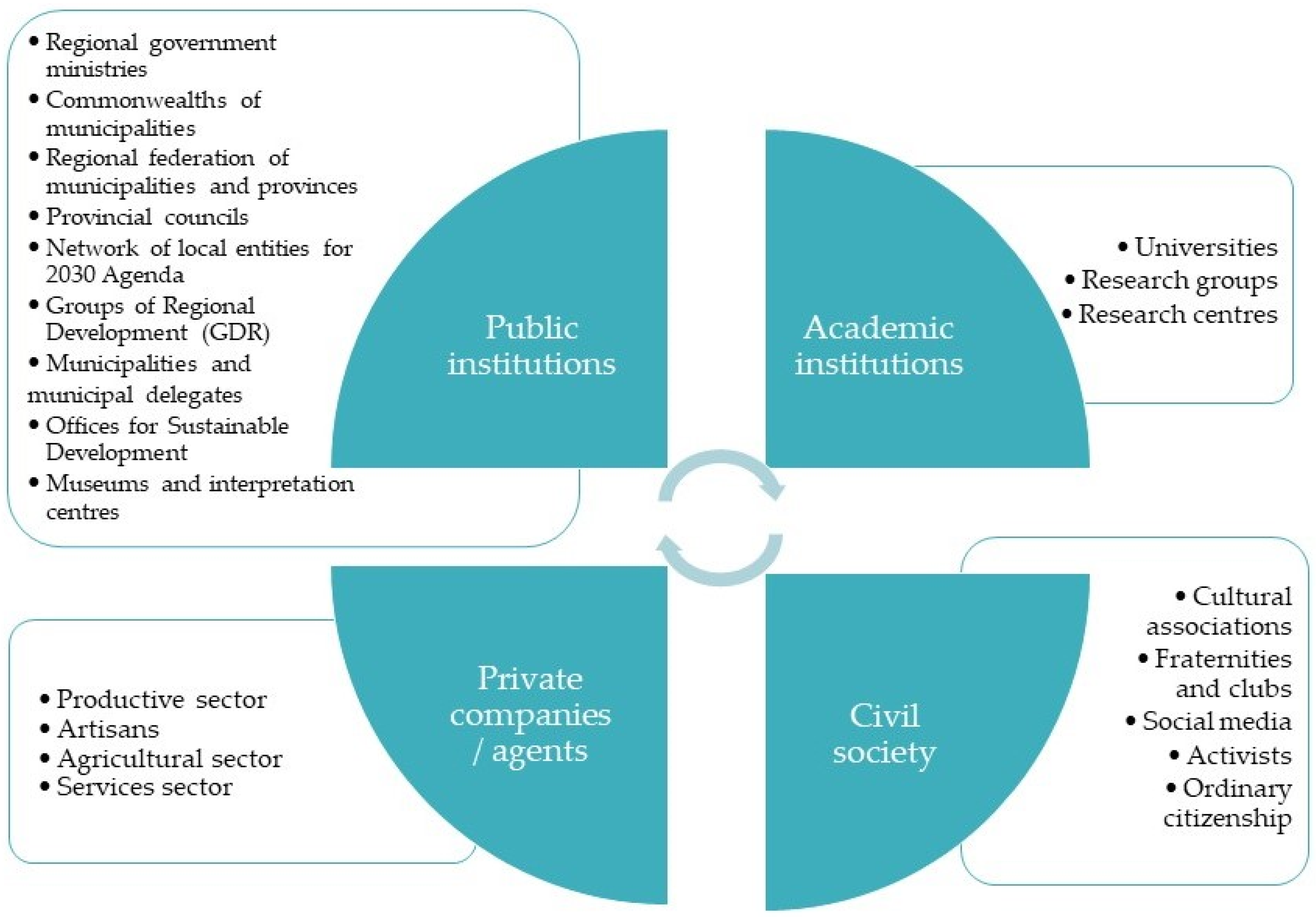
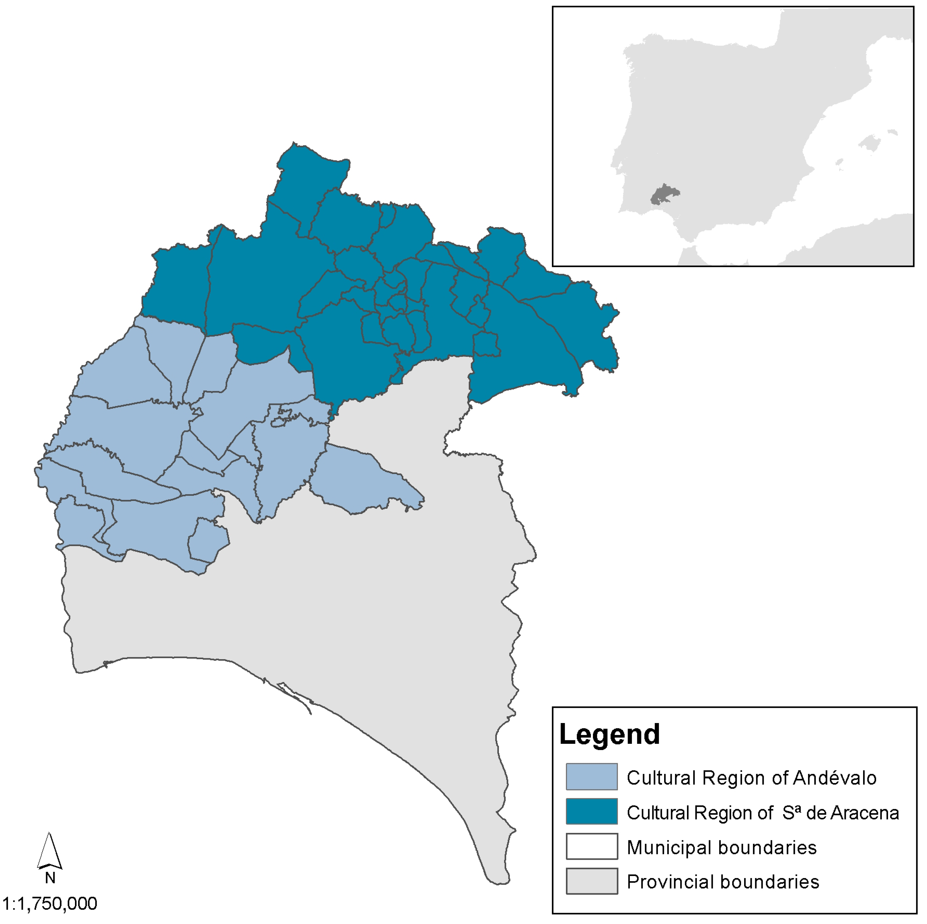
2.1. Presentation of the Case Study and Basis for Citizen Participation

The Rural Heritage Viewer is inserted as a collaborative mapping tool in the technological framework of two R+D+I research projects, the Innovation System for the Heritage of Rural Andalusia (SIN_PAR) and the Tourism Innovation System for the Heritage of Rural Andalusia (SIT_PAR), both led by the IAPH and with the participation of numerous heritage agents. These projects present digital humanities as a strategic resource to facilitate “the connectivity of people, territories and resources” [28] (p. 169). Thus, in the development of the aforementioned research projects, priority is given to applying methodologies that enable collaboration between administrations, specialists in the protection of cultural heritage, public and private agents, and civil society as a whole in the work of protecting cultural heritage. In this collaboration, local citizens are identified as active agents, overcoming “a model centred solely on the capacity of public administrations to determine what cultural heritage means and which are the heritage assets of a territory” [28] (p. 169).
Among the institutional collaboration tools designed such as the innovation workshops for cultural heritage with territorial agents or the bank of sustainable initiatives on the use of cultural heritage in vulnerable areas is the collaborative map of Andalusia’s rural heritage. These tools are located in a web environment, facilitating interaction with citizens through a single site [29] (Figure 1). Through the website, the user can access the Rural Heritage Viewer page [30], as a form of collaboration in the spirit of active participation.
The users of the Rural Heritage Viewer derive mainly from the stakeholders involved in the heritage process and many of them had had previous contact with members of the research team, including the agents invited to the rural heritage innovation workshops organised in the framework of the project, so they are therefore potential publishers of information. The study identified potential publishers in heritage-related institutions, academic institutions, private companies, and civil society (Figure 2).
As for the territorial context of the research, the counties of Sierra de Huelva and El Andévalo (province of Huelva) cover 44 municipalities belonging to the cultural region of Sierra de Aracena and the cultural region of Andévalo (Figure 3). These adjoining counties “constitute a representative group of the rural reality of Andalusia” [26] (p. 9), located in a diverse territorial context, with the presence of municipalities in El Andévalo in clear demographic decline associated with the difficulties of the traditional agricultural sector and the crisis in mining activity. This situation of a demographic crisis is shared by isolated municipalities in the Sierra de Huelva (to the north), with very high rates of depopulation. The contrast in socio-demographic behaviour is presented by municipalities such as Valverde del Camino in Andévalo Occidental and Aracena, Cortegana, Aroche, and Jabugo in Sierra de Huelva, which are developing a productive fabric mainly associated with specific economic activities and rural tourism favoured by their connectivity with the main communication routes [26].
In contrast to the socio-economic situation described above, there is a set of protected and unprotected heritage assets documented through different sources:
  • Protected assets included in the General Catalogue of the Historical Heritage of Andalusia (CGPHA) [31]: They account for 26% of the immovable assets in the scope of representation. According to legal classification, there are 300 Assets of Cultural Interest (BIC): 14 municipal centres declared as Historic Sites; 32 elements of Ethnological Sites of Interest grouped in the Ruedo and Conjunto Hidráulico de La Laguna; 4 Sites of Industrial Interest; 127 assets grouped in the Cuenca Minera Tharsis-La Zarza Heritage Zone; 4 Archaeological Zones; and 56 Monuments. The protected heritage legacy of the area of representation is completed with 63 elements belonging to the protection figure of General Cataloguing.
  • Non-protected assets inventoried in the Andalusian Cultural Asset Management and Information System (MOSAICO) [32]: 872 immovable assets of which 673 are archaeological, 201 of an architectural nature, 59 of an ethnological nature, and 47 of a mixed nature. As for intangible assets, the scope of representation in the viewer includes 121 activities of cultural interest, of which 38 belong to the category of “festive rituals”, 41 to “trades and knowledge”, 27 to “modes of expression”, and 15 to “food and culinary systems”.
  • Territorial systems with a cultural scope: 8 cultural routes run through the study area, 1 of which is autonomous (Andalusian Archaeological Heritage integrated into the Network of Cultural Spaces of Andalusia), another route is provincial (Landscapes of Cultural Interest of the Province of Seville), and the rest are thematic routes associated with mining, hydraulic, and/or wind infrastructures and festive rituals. This category of territorial systems includes the Landscapes of Cultural Interest, of which there are 9 according to the Landscape Register, with security and defence systems, associative ideological systems, and systems for obtaining and transforming resources being represented.

2.2. Description of the Geo-Viewer

The implemented web geo-viewer is based on a bidirectional relationship with the citizen [17], with a web mapping vision with a light and attractive design, which facilitates the participation of users in the identification of cultural heritage as a resource (1) with a special presence in rural areas, contributing to sustainable development and social cohesion in vulnerable areas; (2) territory that interacts in a defined spatio-temporal context; and (3) that must be recognised, perceived, and valued by the citizen for its correct protection and conservation.
There is therefore a priority in the tasks of editing information to generate content in a collaborative way that meets the requirements of being open and reusable. This priority requires an intuitive design, with a simple graphic interface, which allows the handling of a wide variety of agents without expert knowledge of GIT. Furthermore, the navigation and consultation tools are incorporated into the interface in an agile way, facilitating the dissemination of information on heritage without falling into the documentary complexity of the object of study itself.
Likewise, the co-production of information must include options for users to characterise the edited elements as being of cultural interest, independently of the type of agent involved.
Finally, the data collected must be reusable for the tasks of cultural heritage protection, an issue that is resolved by exporting them in GeoJSON files that can be downloaded from the research project website, and, after a process of expert validation of the data collected, their incorporation as documentary information in MOSAICO.
Concerning the standardisation of formats (products, web services, and data quality), the geo-viewer must comply with the specifications of Directive 2007/2/CE, InspirE [33], especially those relating to services, adapted for the Andalusian public administration in the Cartographic Technical Standards of Andalusia [34].

3. Results

3.1. Technical Development of the Rural Heritage Viewer

The Rural Heritage Viewer is based on a light client for visualisation and consultation that incorporates spatial information editing tools, which facilitates the input of information into the database and allows the return of strategic information in cultural heritage management tasks. It is therefore proposed to implement a double functionality: (1) the visualisation and exploration of spatial data interactively and efficiently, and (2) the edition of specific geodata on immovable assets, intangible assets, and cultural heritage agents.
These functionalities are solved with an open source software architecture based on a backend infrastructure hosted in the cloud using Amazon Web Services (AWSs) and an interactive map frontend that stands out for its adaptability and performance.
The main components that make up the technological architecture are the following:
  • Spatial Database: Geospatial data are stored in Amazon RDS (Relational Database Service). Amazon EC2 instances are deployed to host the application backend (automatically scalable according to traffic demand).
  • Geoserver: The Mapbox GL library allows speed in loading data layers and availability of customisable base maps (visual styles, symbols, and labels consistent and in line with the project’s corporate identity). It is adaptable to web, mobile, and desktop applications.
  • Web Client: React technology with the JavaScript UI development library enabling seamless interaction with maps and geodata.
  • Cartographic-based Web Services: Mapbox Streets based on vector coverages of OpenStreetMap data.
  • Security and Access: AWS security groups and firewall rules are implemented to control access to resources with the username and password and protect the infrastructure and data.

3.2. Description of the Rural Heritage Viewer

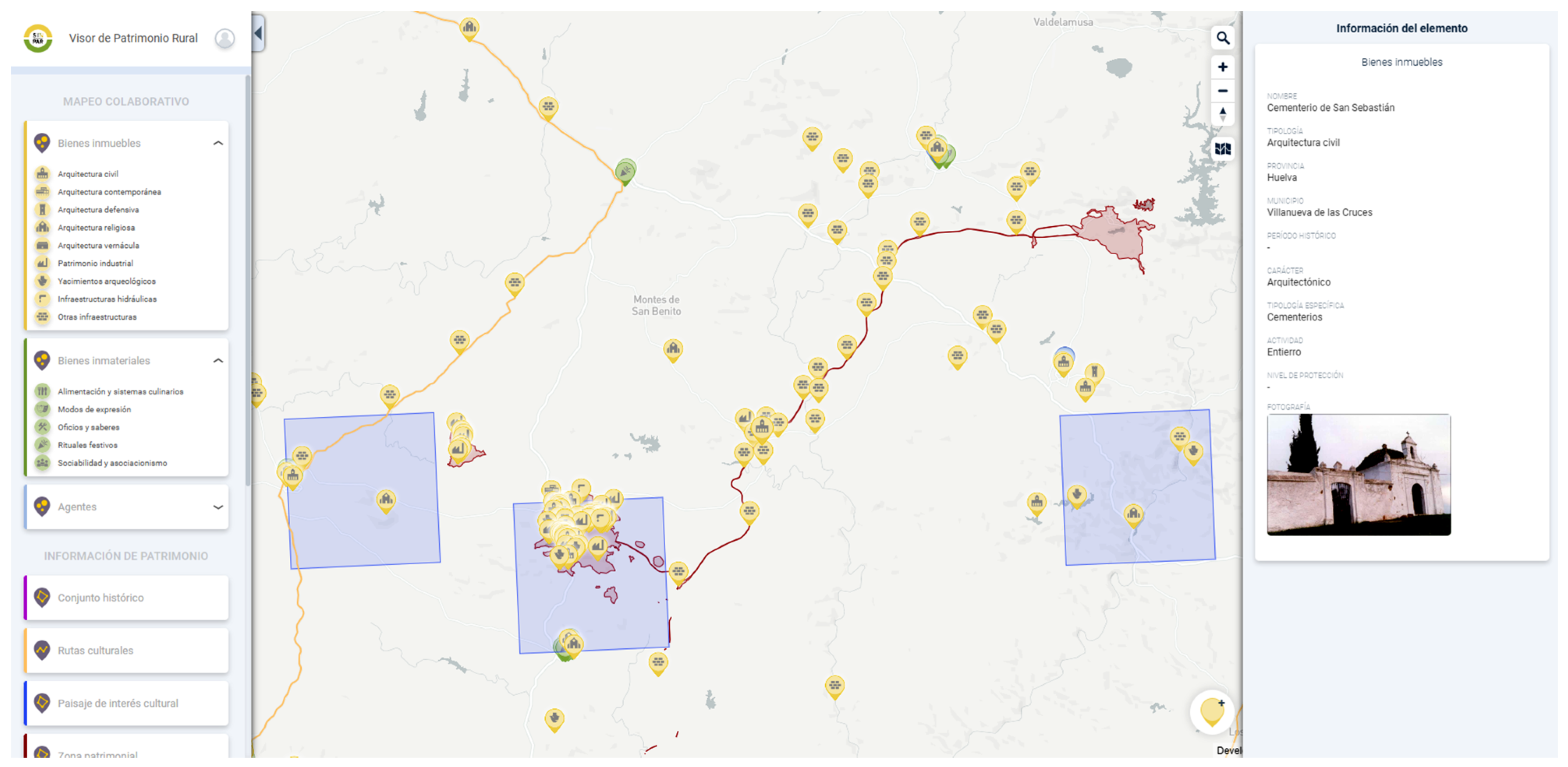
3.2.1. The viewer’s Graphical Interface

The graphic interface solves basic navigation, visualisation, and consultation tasks as well as the possibility of incorporating specific elements through their spatial location. The organisation of the information layers in the table of contents of the viewer presents a block structure (Figure 4), with the editable layers placed in the first place:
  • Collaborative mapping: Editable information layers on immovable and intangible cultural heritage and agents.
  • Heritage information: Territorial context information layers for historical heritage management—territorial delimitation of historic areas or heritage zones, cultural routes, and landscapes of cultural interest.
  • Background information: Sectorial territorial context information layers accessible via WMS (Web Maps Service) relating to urban planning, administrative boundaries of a cultural nature, and municipal boundaries; communication routes for access to cultural assets dispersed in rural areas (paths, trails, livestock trails, cycle paths, greenways, corridors, and green doors); cultural service centres of interest (churches, tourist offices, and museums); territorial figures of management and protection of heritage at a global and regional level; and facilities of protected natural areas.

3.2.2. Information layers: Conceptual Model and Data Sources

Most of the geographic information layers of input in the viewer are freely accessible through WMS and WFS services hosted in the IAPH node of IdeAndalucia. However, it should be borne in mind that there are restrictions on the publication of the location of certain immovable assets for reasons of protection and conservation: unprotected archaeological sites and archaeological sites or sites with the presence of cave paintings, archaeological easement areas, and some protected archaeological sites that for reasons of their state of conservation or difficulty of access are not open to visitors. In addition to the restrictions on the publication of the location of single-family dwellings of ethnological value in the Inventory of Popular Architecture 1992/1997 of the Directorate General of Cultural Heritage and Museums, a necessary restriction is in compliance with Organic Law 3/2018, of 5 December, on the Protection of Personal Data and the guarantee of digital rights. In these cases, the records are not available to the viewer although they can be requested through the Digital Cartography Service of the IAPH [35].
The geodata, accessible through the tools described above, present a conceptual model following the heritage entities to be represented and expressed through point, linear, or polygonal geometry depending on the entity in question and its spatial precision needs. The data models and information sources using thematic blocks are defined with the following:
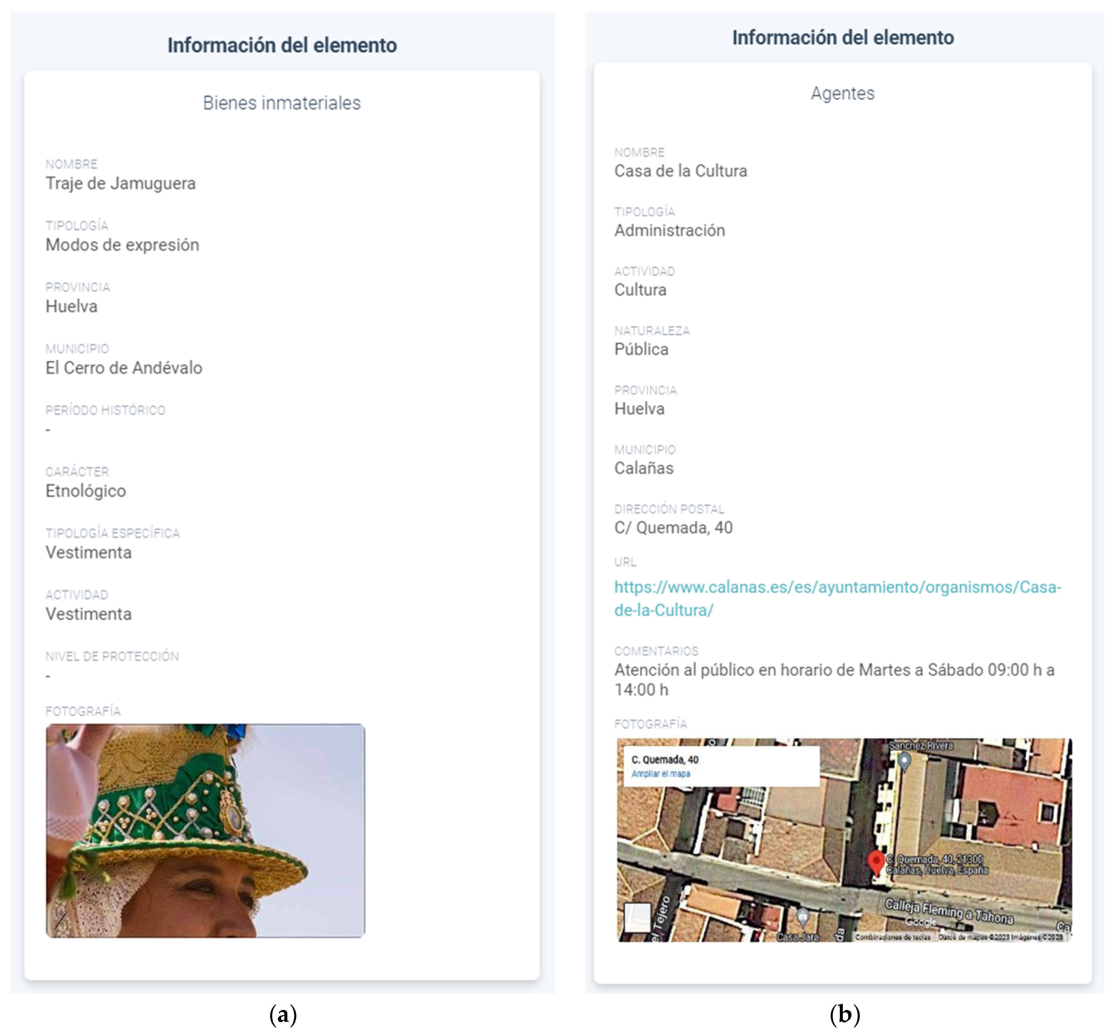
  • Editable information layers. There is a documentary priority in the editable elements of the viewer, so in these cases, the number of accessible fields is more comprehensive with characterisation data of each element detailed following a TESAURO standardisation (Thesaurus of Andalusian Historical Heritage) [23] and the possibility of visualising an image of the asset (see Table 1 and Figure 5). As can be seen in Table 1, only assets relating to built and intangible heritage were considered. Movable heritage was discarded due to the territorial disparity in the documentation of this category in the Andalusian records. All the information layers present a point geometry. It should be pointed out that although the layers of heritage assets do have sources of information, the Documentation and Studies Centre of the IAPH and the General Catalogue of Andalusian Historical Heritage (CGPHA) of the General Directorate of Historical Heritage, in the case of the agents, no prior information is available. In turn, these layers will be complemented and enriched using the editions of information that the different users will incorporate through the tools of the viewer.
  • Information layers of the territorial context of historical heritage management. In the searchable layers of the “Heritage Information” block, priority is given to the incorporation of links to expand the consultation, with the description fields being the nomenclature and typology of the cultural property. These geodata represent groups or associations of assets of cultural interest that respond to a specific territorial and/or normative system [26]: Historic Ensemble, Cultural Route, Landscape of Cultural Interest, or Heritage Area. The sources of information are the Documentation and Studies Centre of the IAPH and the CGPHA.
  • Sectorial territorial context information layers. All the layers present a WMS format whose interpretation is from the legend. Except for the information on land classification whose data source is the Urban Information System (SIU) of the Ministry of Transport, Mobility and Agenda [36], they are served through the WMS Viewer of Spatial Reference Data of Andalusia (DERA) [37] of the Institute of Statistics and Cartography of Andalusia (IECA).

3.2.3. Collaborative Editing Tools for Thematic Mapping

The collaborative editing tools allow (1) the spatial location of a heritage asset (immovable or intangible) or a newly chosen heritage agent, and (2) the standardised description of each element incorporated in the heritage asset characterisation forms, which is carried out following a Thesaurus structure and taking the MOSAICO platform as a reference. Using the interface editing tool (see Figure 5), the user selects the entity to work with, accesses the viewing area to georeference a specific element, and once located, starts its characterisation using a specific form.
The form associated with a heritage property presents a structure of predefined “drop-down”-type fields (Figure 5a) that facilitate the reuse of data in a cultural heritage management context: incorporation with validation in the IAPH inventory; new research projects; intervention initiatives in the territory; etc. In turn, there are certain “open” fields to document the user’s perception and assessment of their heritage legacy. In the case of the incorporation of a new agent, the form presents a structure that prioritises the visibility of rural development initiatives that incorporate heritage resources as strategic and allows opinions and suggestions in the form of comments (Figure 5b).
Finally, the interactive map facilitates the documentation of cultural heritage management initiatives in rural areas, together with their spatial reference, and therefore identifies good practices to be considered in the design of future management actions and proposals.

4. Discussion

The Rural Heritage Viewer facilitates the active collaboration of citizens in the management of Andalusian cultural and architectural heritage. It offers users the possibility both to learn more about their local heritage and to participate in the identification and, therefore, valuation of immovable and intangible assets that they feel as if they were their own. Furthermore, it enhances the creation of collaborative networks through the visualisation of initiatives that, from a concept of sustainable development of vulnerable areas, present cultural heritage as a strategic resource.
This provides a public body of the cultural administration with an additional source of information to the usual ones. It will help produce digital information on the immovable and intangible heritage of Andalusia, incorporating the citizens as fundamental agents in the interpretation of their local cultural heritage. Furthermore, through the tool designed, possible links are created with various agents that intervene in the territory. This will be based on the possibilities that the management of cultural and architectural heritage can offer to actions and programmes for sustainable development and social cohesion in particularly vulnerable rural areas.
The results obtained in the implementation of the geo-viewer yield a series of conclusions about its usefulness and effectiveness in the context of citizen participation:
  • As a tool for dissemination and knowledge for the local population, the geo-viewer acquires a special significance since the research undertaken diagnoses, in the territorial area under study, a clear lack of knowledge of its architectural, archaeological, and intangible heritage assets.
  • As a tool for documenting the lived and perceived heritage in vulnerable areas, it contributes to the work of documenting cultural heritage that the IAPH has been carrying out for decades. It complements other projects such as the Atlas of the Intangible Heritage of Andalusia or the Open Laboratory of the Cultural Heritage of Andalusia.
  • After a process of validation of the data edited in the geo-visor, it is possible to reuse and disseminate them through the Digital Guide to the Cultural Heritage of Andalusia.
  • Finally, the geo-viewer makes it possible to expand the mechanisms for identifying agents and collaborative networks in heritage management along the lines of projects already tested in the IAPH, such as the Network of Andalusian Heritage Informant Agents.
The findings so far allow us to conclude that the design and implementation of the Rural Heritage Viewer can be considered as a pilot experience with a possible continuity in a regional context. This will allow the compilation of thematic cartographic information on heritage for Andalusian coverage. It will also provide a technological response to other IAPH initiatives such as the Network of Reporting Agents of the Cultural Heritage of Andalusia, as well as a tool to extend the interoperable map services available in the IAPH node of the Spatial Data Infrastructure of Andalusia. Within this future line of action, it would be necessary to improve both the visibility of the tool incorporated in the IAPH portal and the processes for downloading the edited spatial information (with data export tools incorporated in the interface).

Author Contributions

Conceptualization, B.D.E.H. and V.R.D.; methodology, B.D.E.H. and V.R.D.; software, V.R.D.; validation, B.D.E.H. and V.R.D.; formal analysis B.D.E.H. and V.R.D.; investigation, B.D.E.H. and V.R.D.; resources, V.R.D.; data curation, V.R.D.; writing—original draft preparation, B.D.E.H. and V.R.D.; writing—review and editing, B.D.E.H. and V.R.D.; visualization, V.R.D.; supervision, B.D.E.H. and V.R.D.; project administration, B.D.E.H.; funding acquisition, B.D.E.H. All authors have read and agreed to the published version of the manuscript.

Funding

This research was funded by Plan Andaluz de Investigación, Desarrollo e Innovación 2020, Consejería de Transformación Económica, Industria, Conocimiento y Universidades de la Junta de Andalucía, Call 2020, grant number PY20_00298, as well as by Call CEIS 2020, grant number PYC20 RE 029 IAPH. No APC was charged for this research.

Institutional Review Board Statement

Not applicable.

Informed Consent Statement

Not applicable.

Data Availability Statement

The data presented in this study are openly available in the IAPH Repository of Digital Assets at https://repositorio.iaph.es/ (accessed on 19 October 2023) and the IAPH node of the Spatial Data Infrastructure of Andalusia at https://www.ideandalucia.es/portal/nodo-instituto-andaluz-del-patrimonio-hist%C3%B3rico (accessed on 19 October 2023).

Acknowledgments

The authors would like to thank the research teams of the SIN_PAR and SIT_PAR projects for their inspiration and ideas that, within the framework of these projects, have contributed to the ideation of this article. They would also like to thank the staff of the Andalusian Historical Heritage Institute, especially the Center for Documentation and Studies, for their involvement in the development and transfer of the cultural heritage information and mapping systems mentioned in this work.

Conflicts of Interest

The authors declare no conflict of interest. The funders had no role in the design of the study; in the collection, analyses, or interpretation of data; in the writing of the manuscript; or in the decision to publish the results.

References

  1. Del Espino Hidalgo, B. Patrimonio, planeamiento y participación: El papel de la ciudadanía en la protección patrimonial local. Rev. PH 2016, 90, 222–224. [Google Scholar] [CrossRef]
  2. Rey Pérez, J. Patrimonio, cultura y gobernanza urbana. Rev. PH 2017, 91, 142–143. [Google Scholar] [CrossRef]
  3. Rius-Ulldemolins, J.; Aróstegui, J.A.R. (Eds.) Treinta años de Políticas Culturales en España: Participación Cultural, Gobernanza Territorial e Industrias Culturales; Universitat de València: Valencia, Spain, 2016. [Google Scholar]
  4. Arjones Fernández, A. Apuntes para un Manual de buenas prácticas para la participación ciudadana en la gestión del patrimonio cultural en Andalucía. Periférica 2015, 16, 45–50. [Google Scholar] [CrossRef]
  5. García Valecillo, Z. ¿Cómo acercar los bienes patrimoniales a los ciudadanos? Educación Patrimonial, un campo emergente en la gestión del patrimonio cultural. Pasos Rev. Tur. Patrim. Cult. 2009, 7, 271–280. [Google Scholar] [CrossRef]
  6. Cortés Vázquez, J.; Jiménez Esquinas, G.; Sánchez Carretero, C. Heritage and participatory governance: An analysis of political strategies and social fractures in Spain. Anthropol. Today 2017, 33, 15–18. [Google Scholar] [CrossRef]
  7. Jennings, E.; Dobreva, M.; Devreni-Koutsouki, A. Towards user engagement models for citizen science: Initiatives in the digital cultural heritage domain. In Cultural Heritage Communities; Ciolfi, L., Areti Damala, A., Hornecker, E., Lechner, M., Maye, L., Eds.; Routledge: London, UK, 2017; pp. 78–95. [Google Scholar]
  8. Finquelievich, S.; Fischnaller, C. Ciencia ciudadana en la Sociedad de la Información: Nuevas tendencias a nivel mundial. Rev. Iberoam. Cienc. Tecnol. Soc. 2014, 9, 11–31. [Google Scholar]
  9. Brigham, R.; Grau-Bové, J. Citizen science in sustainable heritage conservation. In Routledge Handbook of Sustainable Heritage; Fouseki, K., Cassar, M., Dreyfuss, G., Ang Kah Eng, K., Eds.; Routledge: London, UK, 2022; pp. 115–125. [Google Scholar]
  10. Viduka, A. Going for the win-win: Including the public in underwater cultural heritage management through citizen science in Australia and New Zealand. Int. J. Naut. Archaeol. 2020, 49, 87–106. [Google Scholar] [CrossRef]
  11. Dawson, T.; Hambly, J.; Kelley, A.; Lees, W.; Miller, S. Coastal heritage, global climate change, public engagement, and citizen science. Proc. Natl. Acad. Sci. USA 2020, 117, 8280–8286. [Google Scholar] [CrossRef] [PubMed]
  12. Carrera Díaz, G. El inventario como instrumento de salvaguarda. El Atlas del Patrimonio Inmaterial de Andalucía. “Un viaje de ida y vuelta”. e-ph Cuad. 2021, 6, 195–228. [Google Scholar]
  13. Carrera Díaz, G. Propuesta Metodológica para la Documentación y Gestión del Patrimonio Cultural Inmaterial como Estrategia de Desarrollo Social y Territorial. El Patrimonio como Recurso para Vivir. Doctoral Thesis, University of Seville, Seville, Spain, 2016. [Google Scholar]
  14. Rodrigo Cámara, J.M.; Díaz Iglesias, J.M.; Fernández Cacho, S.; Fernández Salinas, V.; Hernández León, E.; Quintero-Morón, V.; González Sancho, B.; López Marín, E. Registro de Paisajes de Interés Cultural de Andalucía. Criterios y Métodos. Rev. PH 2012, 81, 64–75. [Google Scholar] [CrossRef]
  15. Del Espino Hidalgo, B. Heritage Designation and Urban Territorial Balance in Andalusia (Spain): An Approach towards Collaborative Methods in Rural Areas. Land 2023, 12, 974. [Google Scholar] [CrossRef]
  16. Fernández Cacho, S.; Arenillas Torrejón, J.A.; Mondéjar Fernández de Quincoces, P.; Ortiz Lozano, L.; Soro Cañas, S. Evaluación de la gestión y uso de la información de la Guía Digital del Patrimonio Cultural de Andalucía. Rev. PH 2017, 92, 146–168. [Google Scholar] [CrossRef]
  17. Ojeda Zújar, P.; Díaz Cuevas, P.; Álvarez Francoso, J.I.; Pérez Alcántara, J.P.; Prieto Campos, A. Geoportales y geovisores web: Un nuevo entorno colaborativo para la producción, acceso y difusión de la información geográfica. In Análisis Espacial y Representación Geográfica: Innovación y Aplicación; De la Riva, J., Ibarra, P., Montorio, R., Rodrigues, M., Eds.; Universidad de Zaragoza y Asociación de Geógrafos Españoles: Zaragoza, Spain, 2015; pp. 777–786. [Google Scholar]
  18. Paneque Salgado, P.; Vargas Molina, J.; Lafuente Fernández, R.; Rodríguez Díaz, V. Geovisor colaborativo para la evaluación de la vulnerabilidad al riesgo de sequía. In Proceedings of the X Congresso Ibérico de Gestão e Planeamento da Água, Coimbra, Portugal, 6–8 September 2018. [Google Scholar]
  19. Gis and Coast. Available online: http://www.visor.gis-and-coast.org/ (accessed on 1 September 2023).
  20. Observatorio Ciudadano de la Sequía. Available online: https://observasequia.es/ (accessed on 1 September 2023).
  21. Conoce tus Fuentes. Available online: https://www.conocetusfuentes.com/home.php (accessed on 1 September 2023).
  22. Sevilla Tu Ciudad. Available online: https://www.sevilla.org/servicios/participacion-ciudadana/sevilla-tu-ciudad (accessed on 1 September 2023).
  23. Guía Digital del Patrimonio Cultural de Andalucía. Available online: https://guiadigital.iaph.es/ (accessed on 1 September 2023).
  24. Catálogo General del Patrimonio Histórico Andaluz. Available online: https://www.juntadeandalucia.es/organismos/turismoculturaydeporte/areas/cultura/bienes-culturales/catalogo-pha.html (accessed on 1 September 2023).
  25. Infraestructura de Datos Espaciales de Andalucía. Available online: https://www.ideandalucia.es/portal/ (accessed on 1 September 2023).
  26. Del Espino Hidalgo, B.; Rodríguez Díaz, V.; González-Campos Baeza, Y.; Santana Falcón, I. Indicadores de accesibilidad para la evaluación del patrimonio cultural como recurso de desarrollo en áreas rurales de Huelva. ACE Archit. City Environ. 2022, 17, 11375. [Google Scholar] [CrossRef]
  27. Del Espino Hidalgo, B. Dos proyectos de investigación abordan estrategias para la gestión patrimonial y turística de las áreas rurales andaluzas. Rev. PH 2023, 108, 14–17. [Google Scholar] [CrossRef]
  28. Del Espino Hidalgo, B. Patrimonio, personas, territorio. El papel de los recursos digitales en áreas rurales. Rev. PH 2023, 109, 169–171. [Google Scholar] [CrossRef]
  29. SIN[T]_PAR Project. Available online: https://www.patrimonioruralandalucia.es/ (accessed on 1 September 2023).
  30. Rural Heritage Viewer. Available online: https://mapa.patrimonioruralandalucia.es/ (accessed on 1 September 2023).
  31. Query Tool of the Catálogo General del Patrimonio Histórico Andaluz. Available online: https://www.juntadeandalucia.es/organismos/turismoculturaydeporte/areas/cultura/bienes-culturales/catalogo-pha/consulta.html (accessed on 1 September 2023).
  32. MOSAICO Platform. Available online: https://ws096.juntadeandalucia.es/mosaico/faces/jspx/portadaMosaico.jspx (accessed on 1 September 2023).
  33. INSPIRE Geoportal. Available online: https://inspire-geoportal.ec.europa.eu/index.html (accessed on 1 September 2023).
  34. Normalización en el Sistema Estadístico y Cartográfico de Andalucía. Available online: https://www.juntadeandalucia.es/institutodeestadisticaycartografia/ieagen/sea/ntca/normalizacion.htm (accessed on 1 September 2023).
  35. Service of Digital Cartography of the IAPH. Available online: https://www.juntadeandalucia.es/servicios/sede/tramites/procedimientos/detalle/18939.html (accessed on 1 September 2023).
  36. Sistema de Información Urbana. Available online: https://www.mitma.gob.es/portal-del-suelo-y-politicas-urbanas/sistema-de-informacion-urbana/sistema-de-informacion-urbana-siu (accessed on 1 September 2023).
  37. Datos Espaciales de Referencia de Andalucía (DERA). Available online: https://www.juntadeandalucia.es/institutodeestadisticaycartografia/DERA/index.htm (accessed on 1 September 2023).
Figure 1. Web context in which the Rural Heritage Viewer is embedded.
Architecture 03 00035 g001
Figure 2. Main profiles of viewer editing agents.
Architecture 03 00035 g002
Figure 3. Territorial context of the Cultural Heritage Viewer.
Architecture 03 00035 g003
Figure 4. Interface of the Rural Heritage Viewer.
Architecture 03 00035 g004
Figure 5. Editing tools: (a) Editing a patrimonial object; (b) Editing a patrimonial agent.
Architecture 03 00035 g005
Table 1. The data model of the editable viewer layers.
ObjectFieldDescriptionDomain
ImmovableNameName of the assetFree text
TypologyFunctional assignment of the assetArchitecture: civil, contemporary, defensive, religious, vernacular, industrial heritage, archaeological sites, hydraulic infrastructures, and other infrastructures
ProvinceName of the province8 Andalusian provinces
MunicipalityName of the municipality785 Andalusian municipalities
Historic periodHistorical period to which the asset belongs chronologicallyPrehistory, Ancient Ages, Middle Ages, Modern Ages, Contemporary Ages
CharacterDisciplinary characterisationArchaeological, architectural, ethnological, or combined
Specific typologyTypology of the functional attribution of the assetFree text
ActivityActivities carried out on the siteFree text
Level of protectionProtection status of the assetBIC, CG, Municipal Urban Catalogue
PhotographPhotograph of the asset
IntangibleNameName of the assetFree text
TypologyFunctional attribution of the assetFood and culinary systems, means of expression, trades and knowledge, and sociability and associations
ProvinceName of the provinceIdem
MunicipalityName of the municipalityIdem
Historic periodHistorical period defining the chronological ascription of the assetIdem
CharacterDisciplinary characterisationEthnological
Specific typologyTypology defining the functional attribution of the assetFree text
ActivityActivities associated with the assetFree text
Level of protectionLevel of protection of the assetIdem
PhotographPhotograph of the asset
AgentNameName of the agentFree text
TypologyFunctional attribution of the agentAdministration, academic, company, association, foundation, individual, and others
ActivityActivities associated with the agentTourism, crafts, local development, nature, gastronomy, agriculture, management, administration, museums, revitalisation, research, archaeology, architecture/construction, culture, art, and others
NatureLegal nature of the agentPublic, private, non-profit, other
ProvinceName of the provinceIdem
MunicipalityName of the municipalityIdem
Postal addressCP in which the agent is locatedFree text
URLWebFree text
CommentsCommentsFree text
PhotographPhotograph of the agent
Disclaimer/Publisher’s Note: The statements, opinions and data contained in all publications are solely those of the individual author(s) and contributor(s) and not of MDPI and/or the editor(s). MDPI and/or the editor(s) disclaim responsibility for any injury to people or property resulting from any ideas, methods, instructions or products referred to in the content.

