3.1. Identification of Analytical Features
Next to being representational, drawings, photographs, and films also articulate a specific reflection on cultural concepts in the “real” world. The way artists observe, perceive, and eventually process their impression of these places into drawings, photographs, or films can reveal the legibility and understanding of these everyday landscapes.
As reflections, these works express ideas that structure everyday life practices. When selecting a particular place and establishing a setting, drawings, photographs, and films give us insight into the sense and meaning of a place. By depicting specific areas, in this case peri-urban landscapes, not only the characteristics of the area itself are revealed, but also the attachments people and communities possess to these landscapes become visible. These social constructions and reflections in drawing, photography, and cinema give us insight into what Henri Lefebvre defined as “lived space” in
The Production of Space [
1]. As a part of the totality of space as a product,
lived space is the experience of living in an environment mediated through the expectations of its representation. The perception of the environment itself is what Lefebvre designated as the
perceived space, which is the space of scientists and urbanists. The
conceived space is the representation of the environment, the space of architects. Both perceived and conceived space are subjected to the process of rationalization. The lived space is much harder to grasp and often out of the planner’s gaze.
The introduction of an analysis based on the contemporary work of artists in the fields of drawing, photography, and cinema offers a particular way to discover social constructions and reflections. An analysis of techniques in stylistic effects aims to highlight the lived space through aspects such as the use of colour, level of detail, lighting, composition, montage, optics, the presence or absence of people in the image, and presentation, among others, that express spatial and sociocultural themes. In this creative process, artists decide on a wide range of aspects that generate impressions and subtexts that reflect their subjective experience of a place. Therefore, by interviewing the artists about their choices along the creative process, the impressions and subtext of the artists’ perspective on the world is revealed.
In the selected drawing practices, the artists counter the need for legibility, unity, wholeness, and coherence using drawing techniques that focus on lines and by adding colours. Birgit Cold used the sketch as a craft to capture the dominant environmental qualities. Therefore, she chose motifs that she could read and understand. Out of the motifs, she read structure as a coherent, understandable whole created by recognizable repetitions of patterns, lines, shapes, and forms. Like eighteenth-century artists such as W. Hogarth, she reflected on the beauty of the S-shape, which seemed an ideal shape for her
1. Moreover, she added colours as another precognitive effect and stated that the influences on our aesthetic preferences are both cultural, individual, and innate. Inspired by Cold’s work, Ingfrid Lyngstad regards silhouettes as important lines. For her, “
the silhouettes are interesting, they are what our gaze searches for, where the ground meets the sky. It is something innate in us. In urban sites, a natural silhouette adds identity of the place [
26]”. Lyngstad’s focus is on changes in surroundings in everyday landscapes and how laypeople rediscover these important lines after a change has been made [
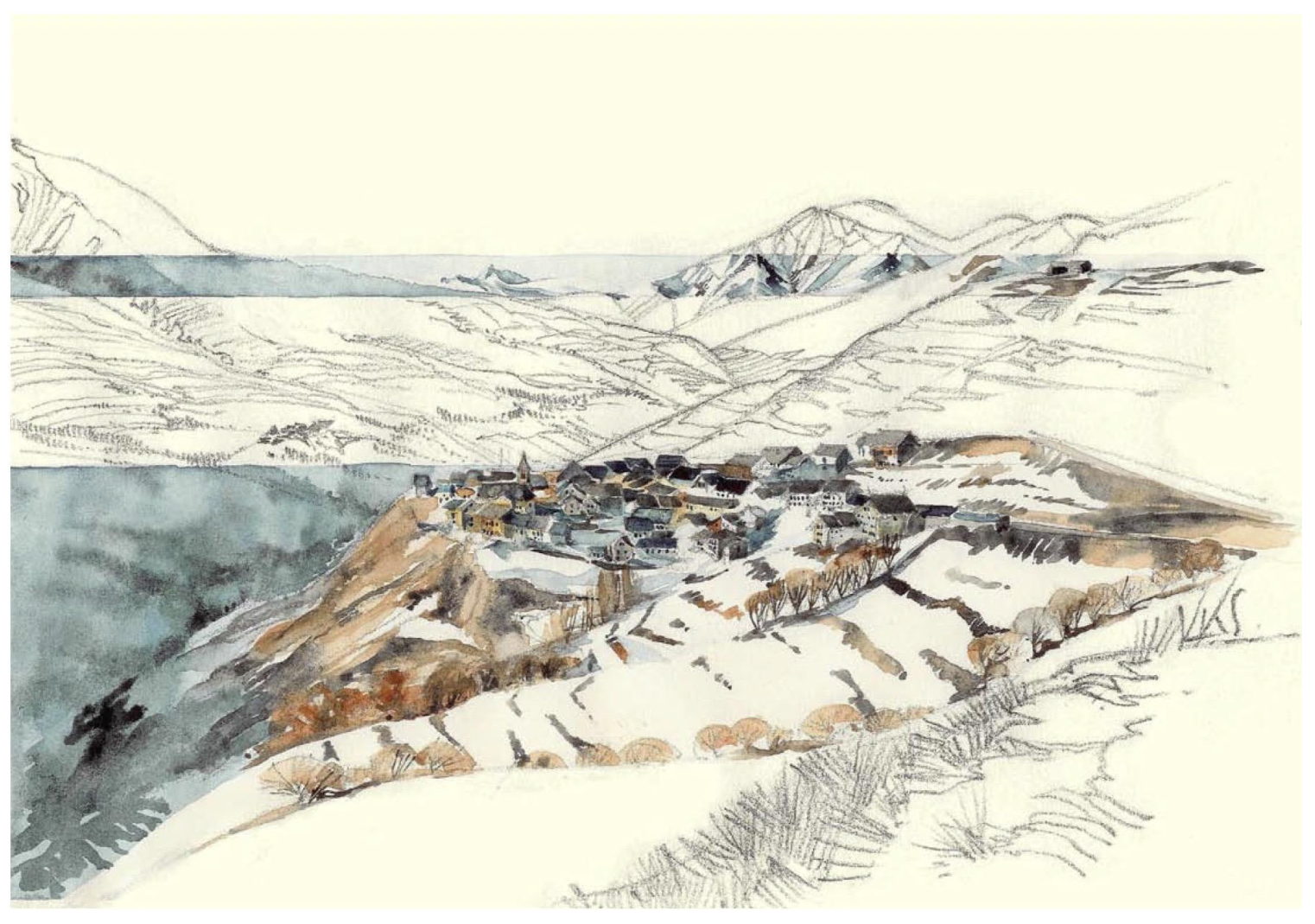
13]. Véronique Simon sometimes combines drawings with aquarelles, which adds colours to her interpretation of landscapes. In one project, this decision to add colour was in response to the local people and people in the municipality that commissioned the project: “
Without colours they felt a distance to the motif. They wanted to show how alive the place was, therefore they wanted the colours on. This was interesting, as this is a place with inhabitants that really love their landscape [
15]” (see
Figure 1).
The selected photographers explore the “less picturesque” dimensions of the built and unbuilt landscape, focusing on different types of subjects and employing various techniques. Gabriele Basilico recurred to a method that attempted to “isolate” built elements from the quotidian movement hidden from our “confused and myope” gaze [
27]. Basilico establishes this juxtaposition between the built environment and the other elements of the city to portray and document Milan’s “functional” landscapes. Ernesto Fantozzi’s approach contrasts with Basilico’s technique. Instead of images devoid of people, Fantozzi portrays cultural and social expressions of everyday life in the emerging peripheral neighbourhoods, mainly built for migrants from the southern Italian regions. Filippo Romano and Francesco Secchi both capture abandoned, underused, and even non-completed spaces and infrastructure. Both photographers maintain a dialogue with cartography. On the one hand, Romano’s work introduces an alternative cartography by assessing and critically analysing the spatial revelations of social and political conflicts. On the other hand, Secchi’s images are placed in dialogue with a spatial cartographical analysis of the territory.
In many of his documentaries, Jef Cornelis analysed urbanisation in Flanders by employing an observational style. He combined his particular interest in how architecture shapes urban spaces and influences interactions with collaborations with artists, architects, and urban planners. This resulted in films that convey not only a strong sense of place but also critical reflections on the challenges and issues faced by these environments. Moreover, Jef Cornelis is known for using innovative cinematic techniques in his films. For instance, in some of his films, such as De Straat (
The Street, 1972), Cornelis deploys breath-taking aerial shots and high-action opening scenes, exposing the city and its inhabitants from a unique perspective. Two of his films on Flemish urbanisation, namely
Vlaanderen in vogelvlucht (
A bird’s eye view of Flanders, 1976) and
Vlaanderen 77 (
Flanders 77, 1977) [
28], are defined by the use of helicopter images of the Flemish landscape.
Vlaanderen in vogelvlucht is constructed entirely from helicopter images, while in
Vlaanderen 77, these are interspersed with archive images, photographs, and maps.
Van Groeningen’s fiction films that were introduced above not only document the everyday environment of Flanders’ peri-urban spaces, but they also lighten a certain appreciation for these neglected areas. By embedding his films in the authenticity of Flanders, not the touristic postcard images, and ascribing these locations a prominent role in the storyline, the director demonstrates the rear sites as a place where individual desires and subcultures, often neglected by policymakers and planners, can thrive. Moreover, there is a certain poetry in the constantly returning duality between raw realism and surreal poetry in Van Groeningen’s work. This juxtaposition is often explicitly visible in the montage of images and supported by the soundtrack. In sum, the films visualize the urbanised beauty of Flanders.
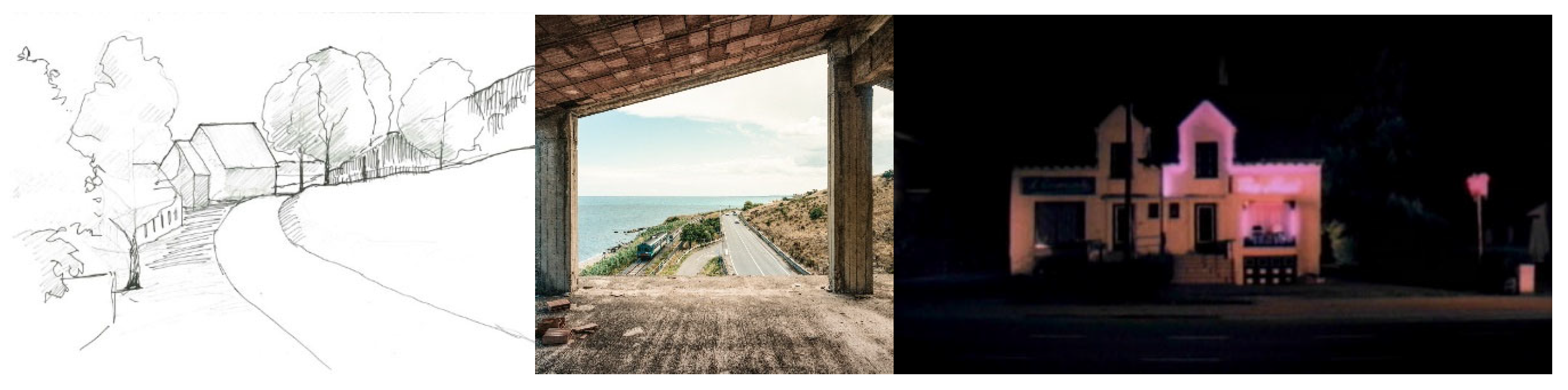
The theme of the “road” appears to be a recurring motif across the different fields analysed in this article (see
Figure 2). For instance, in Vennesborg [
13], Lyngstad was drawing, amongst others, along an old path and included narratives and place names in her landscape analysis. By utilizing historical sources, she connected place names with physical features on the site, allowing the narratives to evolve and incorporate historic events of this specific society [
13].
Romano’s project
Statale 106 portrays the complexity of southern Italy by choosing as its subject a road along the coast that connects Reggio Calabria and Taranto. His photographs narrate a multifaceted territory, revealing the aesthetics and encounters with its inhabitants. This road starts and ends, or connects, two of the unfinished ambitious industrial projects planned by the state. Romano’s work captures these “broken” promises narrated through fragments, yet the road gives “
identity and continuity” [
29].
The documentary film De Straat (The Street, 1972) by Jef Cornelis focuses on how motorized traffic in our cities has replaced everyday community life and activities on the streets. The film offers a detailed and observational portrayal of this specific urban environment, capturing the interactions, routines, and dynamics of the people who inhabit and traverse the street. By interspersing shots of Belgian cities overrun by cars and trucks with idyllic sequences of places in Italy where children spend their entire day on the streets, the decay of these public spaces into places of mere transportation is accentuated.
In Steve+Sky, the road with its surrounding parking lots, big stores, brothels, Chinese restaurants, gas stations, etc., is literally a way of connecting the protagonists: Sky frequently slowly crosses the frame, walking along the road, indicating this is her biotope. On the contrary, the roundabout is linked with Steve and filmed with a camera shooting down on the cars riding and Steve running in rounds. Both of them come together in the clear blue water of one of the store’s model swimming pools along the road. This peri-urban landscape is portrayed through a recurrent structure of static, frontal, extreme long shots, neutrally portraying the isolated buildings bordering the road, evenly distributed over the entire length of the film.
Interviews with architect Veronique Simon, photographer Filippo Romano, and director Felix Van Groeningen revealed how three comparable steps can be discerned in the creative process of these artists. These three artists start with a study or research phase, followed by “recording” or work on the field, and complete the process by establishing a narrative in the form of a sequence, the “montage”.
3.1.1. Research Phase in the Artistic Process
For Véronique Simon, who combines drawings with participation as a tool in developing landscape analysis, the research phase implies being in the field, without prejudging and observing. As she explains her process of being present with the motif and letting it tell its story while working on it: “
I don’t start at once. I sit down before the landscape and view it. When my eye captures something interesting, a detail, I want to draw, I start there and continue. It can be a movement in the landscape, a node and so on. I am often guided by emotion.” [
14].
Filippo Romano points out that research is essential for photographers to give depth and context to their work. He approaches it by carefully studying the “masters” of photography, their techniques, and other photographers who have already worked in the same places. He also enjoys literature, history, and cinema as disciplines that can provide additional insight into these places. Romano’s work is a clear example of how gaining a historical context further enriches his curiosity and interest in a specific project. Sometimes, this activity is performed before or even after his fieldwork. He sees it as a continuous, evolving process. He considers that these projects rarely have an end. They are a permanent dialogue with the territory, people encountered, and previous works [
29].
Felix Van Groeningen explains how he meticulously composes the places where his films take place. Most of the design, creation, ideas, and decisions are made in the preparation phase of the movie. Moreover, throughout Van Groeningen’s films, these places are, just like the characters, evolving throughout his movies. Rather than just serving as a visual backdrop, the settings underscore the narrative and its developments.
3.1.2. Record Phase in the Artistic Process
With the act of drawing, the place is translated to a flat piece of paper. In this act, the atmosphere and the life in the place are excluded, and only the physical form is interpreted. “
You lose something, the sounds, and to draw outside in all kinds of weather can be limiting. But you can overcome this; by making quick sketches, using photos, and drawing by mind later. It gets a lot deeper into you [
14].” Drawing is a slower way to observe, which is to the advantage of the drawer, who has the time to listen, smell, view, and extend the experience. “
You start to draw, let’s say (in) A4 format, and the drawing extends outside this. You need to get everything that is important into the representation to understand the whole [
14]”. This way, the artist comes closer to understanding the composition and the coherence in the landscape, the formal qualities of this environment. As for peri-urban spaces, this is often chaotic and fragmented.
As a photographer, Romano considers himself not only a documentarian but also an observer. His neutral and observational gaze reflects his curiosity and commitment. In projects such as
Statale 106 or his work in Nairobi, his authorship is revealed from the initial state of choosing these projects as a personal journey in which photography becomes his means for establishing a close relationship with these territories. For him, the fact that these projects are not commissioned gives the artist the artistic and social freedom to engage in and shape their journey. He considers that commissioned projects could be more limited in this sense, as expectations and objectives surround them. Politicians or other stakeholders see photography as a “marketing” activity. Romano’s project
Marea oggi,
marea domani, commissioned by the Cavallino Treporti municipality near Venice, challenged his working method. However, he feels that he was able to objectively narrate the economic transition experienced by this area from an agricultural to a tourism-based economy [
29].
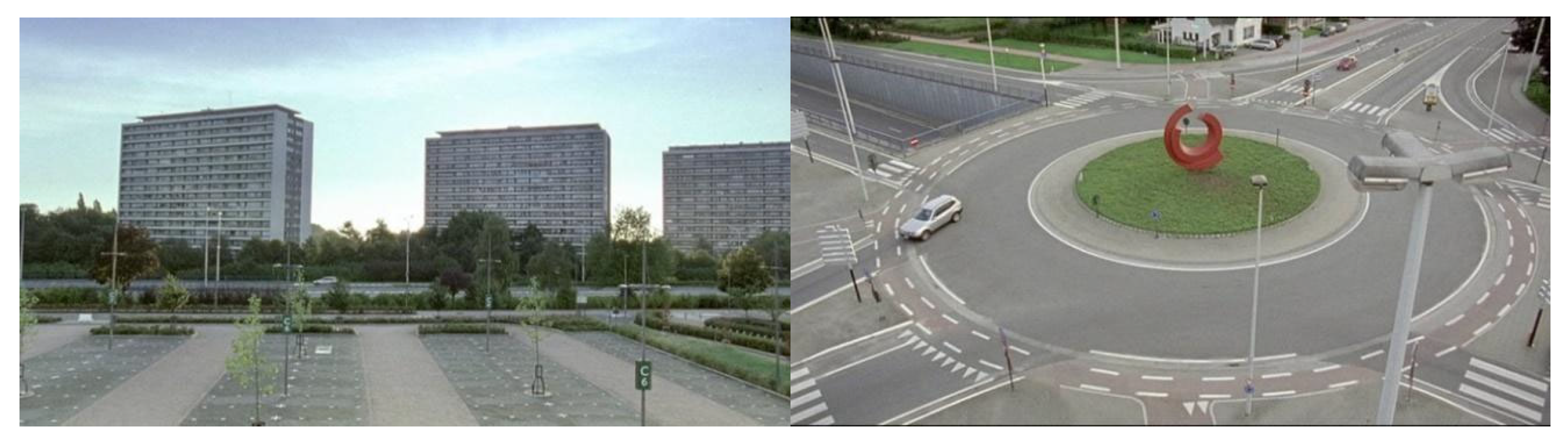
Van Groeningen regards the settings as an essential element that he employs to indicate, mirror, or magnify the feelings, experiences, and connections of the characters. Van Groeningen explains how he created and stressed the feeling of loneliness and emptiness in
With Friends Like These by making use of the setting: “
there was so much grey or silver in the image, and the towers, the apartment that was big and empty, and a roundabout that is even uglier. (…) the shiny, that emptiness, that is what we exaggerated. There are almost no people in the image, you almost never see other people or other cars, really being alone and empty in that city [
30]” (see
Figure 3).
3.1.3. Montage Phase in the Artistic Process
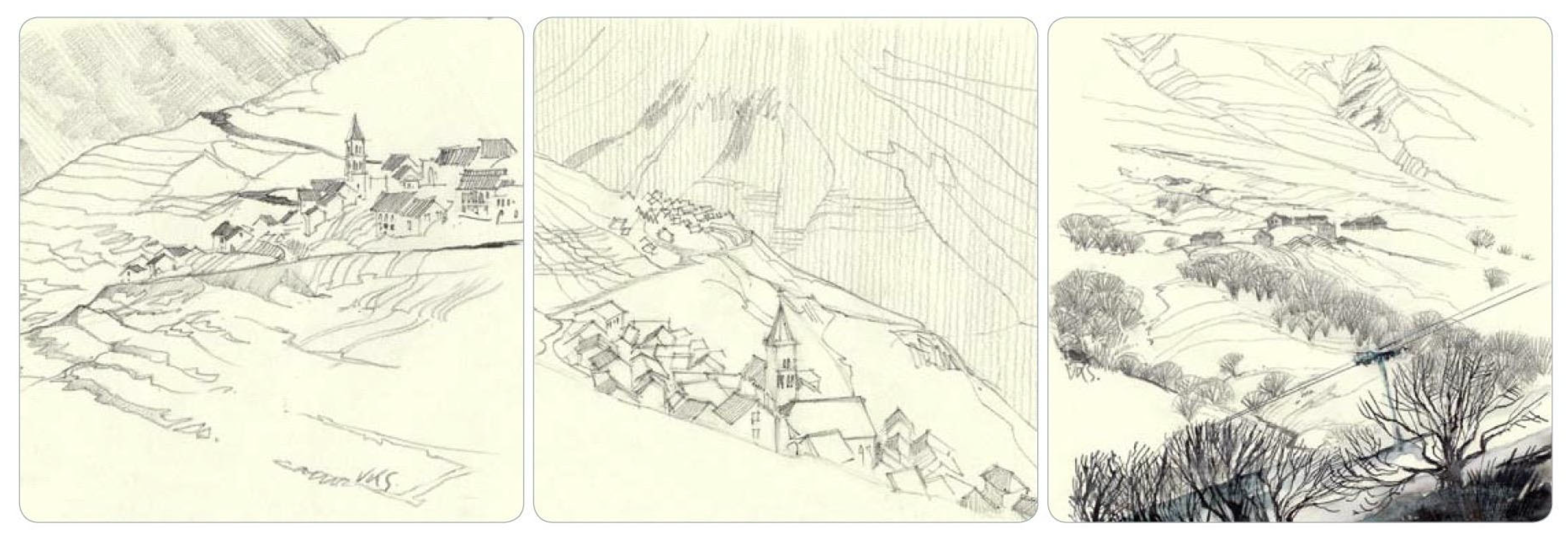
The drawing is the principal tool to start a dialogue in the project of Veronique Simon. By means of drawings made in the field, it is possible to reach participants’ emotions and affiliation to the landscape in a different way from the computer and GIS methods. These representations perform less expertly compared to other methods for analysis. The drawing still visualises the unity, rhythm, distinctiveness, and spatial connections with legibility. These are qualities that often need to be given more concern compared to pure economic values. When the villages in
Les Traverses de La Grave [
15] were visualised with their distinctions in drawings or aquarelles, the memories and the relationship to this place seemed to become clearer to the local inhabitants. Much of this knowledge is subconscious or forgotten, and people do not think much about it until we are reminded, as in the project in France [
19] (see
Figure 4).
Romano points out that the history of photography is made from photography books. “
Which are, literally, sequences of images thought and studied in a certain way. In which the first and last image are the first and last. They are not randomly organized [
29]”. He also points out that photography “
survives through authorship [
29]”. He considers that nowadays, we are surrounded by an infinite number of images, and we are not selecting or analysing. Romano emphasizes that the act of “selecting” and “constructing a sequence and a narrative” is how photographers construct “authorship”. As emphasized by Romano, among the limitations of photography is its “fragmentary” nature due to the stillness of its technique. However, it is compensated by the photographer’s capacity to establish a narrative in the form of a sequence, by embarking on prolonged projects, and by the continuity given to the works of previous photographers [
29]. This “layering” form of approaching photography demands someone’s commitment, possibly even that of public institutions, to archive photographs and make them accessible for public use by establishing specialized libraries with robust collections of photographic books. Nevertheless, there is also the commitment, in this case, of planners and researchers to actively use these resources. This entails a shift in how we approach searching for and utilizing images, fostering collaborative relationships with photographers, and purposefully integrating them to gain a more profound insight into territories and everyday life.
Van Groeningen clarifies how he creates places and comprehensive narratives through a montage of images. In
The Misfortunates, there are two defining spatial elements, namely the village and the train. On the one hand, the village is entirely situated in the past, and Van Groeningen describes how this cinematic entity is in fact a composition of four or five existing villages. “
There is one village with that church, the house was in another village, there were a number of incredible small pubs (…) and the train station [
30].” On the other hand, the train is deployed to connect the present with the past. The train is interwoven in the story and visually present: the train passes by as the protagonists’ cycle through the landscape or as they swim in the river, Gunther crosses the railway tracks or takes the train to go to school, etc. The train offers Gunther a way to escape but remains present in his life, as he does not get away. The train’s pervasive presence stresses how he is always connected to his past situation. Other visual motifs originated only during the montage. The screens filled with blue, representing at certain moments water or a non-clouded sky at other moments, in
Steve+Sky are such an example. It is a way of connecting things in a story that is not told chronologically. These returning images support the understanding and add extra meaning.
3.2. Identification of Documentational Aspects
Documentation is an activity that aims to capture the state of a given place at a specific time. It is embedded in research and planning processes and can be carried out in multiple forms and techniques. Documentation alone can also be the final and expected outcome of a research project such as the
DATAR Photographique Mission, which, in the 1980s, commissioned twenty-nine photographers to document the French landscape [
17]. Another example is the objective of the
Museo di Fotografia Contemporanea (MUFOCO) to become the first public museum and photographic archive in Italy focused on conserving, cataloguing, and studying photography. Therefore, in photography, documentation can occur as an individual and collective activity, sometimes intentionally and more often as a historic recompilation of the bodies of work of different generations of photographers, as expressed by Romano [
29].
Although forms of documenting are directly associated with photography and documentary film as a specific genre, this text also explores how places and spaces get documented by being portrayed in a feature film. Since cinema combines visual, spatial, and temporal elements, it can represent versatile information about space. Directors often focus their camera lens on the everyday, revealing daily life, its intrinsic characteristics, and typical dynamics through visual portrayal and storylines.
Lastly, the text explores the documentation process as part of a creative process that involves previous research, decision-making, and narrative building through the specificity of the techniques of the chosen medium. For instance, in landscape drawing, artists and practitioners carefully document and represent a landscape through a process that involves observing, choosing a frame, identifying features and motifs, and often redrawing the same view at different moments. These decisions impact the outcome and shape the results of the documentation process.
3.2.1. Documenting over Time
Documentation is an activity that can be prolonged throughout time in various forms and is specific to the medium being used. For instance, the 1975 exhibition
New Topographics: Photographs of a Man-Altered Landscape, curated by William Jenkins, is the historical turning point in which photography intentionally started looking at “non-idealized landscapes” and focusing on the “anti-aesthetic” of the quotidian. It placed photography as a potential witness of “social critique” of the fierce transformation of cities and lifestyles in the creation of these “non-places” [
31,
32,
33]. Later generations of photographers have given continuity to this “form” of portraying and documenting spaces. The main features and elements of the
New Topographics are still recognizable and are used to evidence the specificity of places, often focusing on neglected areas and under-planned or failed planning processes. Therefore, continuity in documentation is given by new generations able to recognize and reproduce a common language to express contemporary issues.
The long-term evolution of specific places over time has also been explored and documented in film. For instance, in
Helsinki Forever (2008) [
34], Van Bagh depicts the Finnish capital’s evolution over several decades by stitching together footage from fiction, documentary films, photographs, and paintings. Similarly, Thom Andersen used clips from hundreds of fiction films in
Los Angeles Plays Itself (2003) [
35] to demonstrate how that city has been represented on screen over time and how those representations have impacted our perception of the city. Such movies inspired François Penz et al. to set up their so-called “cinematic urban archaeology”, a methodology based on investigating film imaginaries of a specific area to grasp urban phenomena’s complexity. Also, “
the increasing availability of digitally stored archive material makes such retrospectively ‘longitudinal’ cinematic studies (e.g., of a particular area through time) increasingly fruitful [
36] (p. 193)”. In these specific cases, there is an explicit desire to explore a place over time.
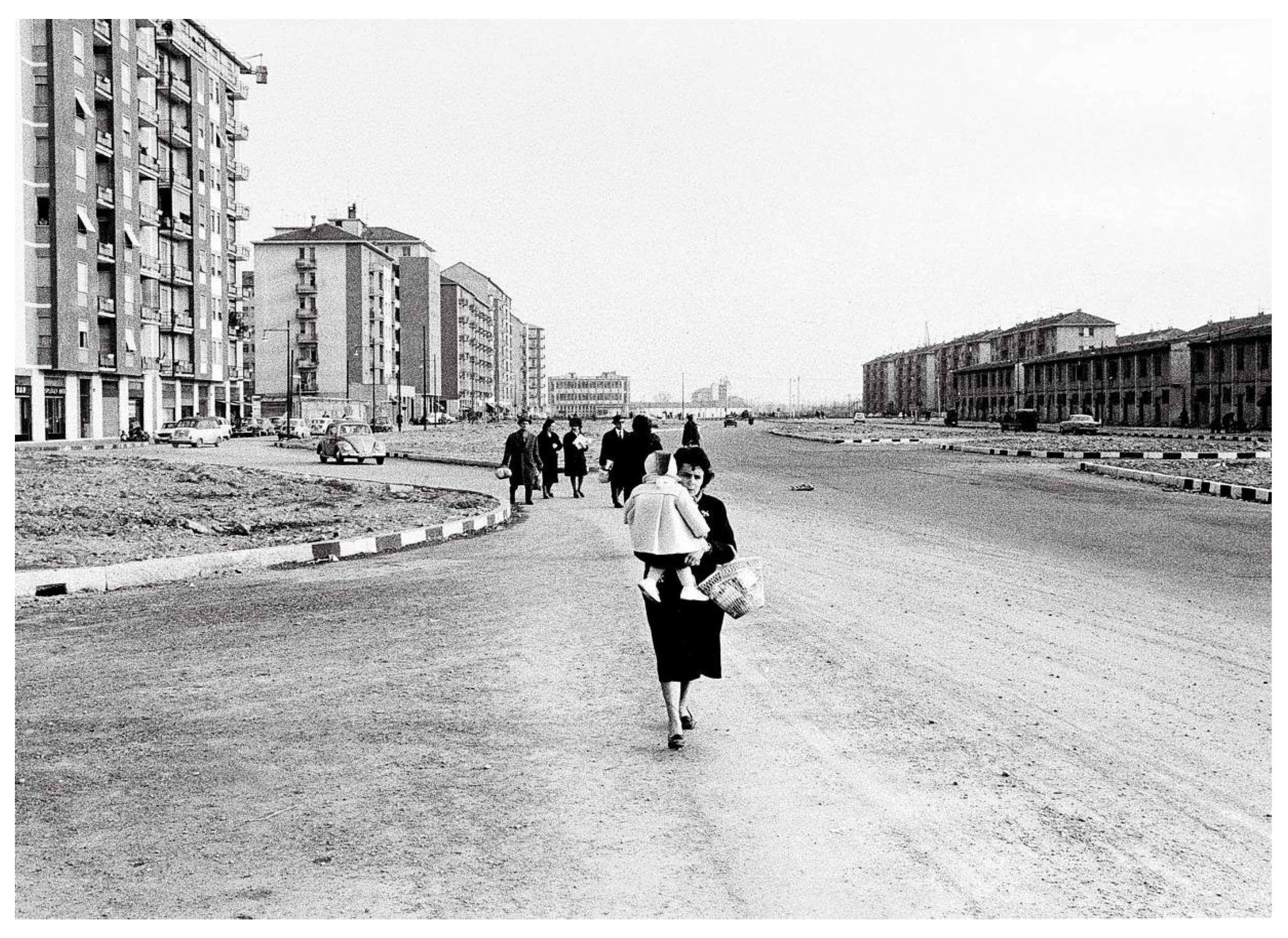
Similarly, in photography, a body of work can be used to understand how a place has changed spatially and socially. The work of Ernesto Fantozzi, recently exhibited at the
Museo di Fotografia Contemporanea [
37], revealed a lifetime commitment to explore the Milanese “peripheries” from the 1950s to the turn of the new century. Fantozzi’s work focused on documenting “spontaneous situations” occurring in the post-industrial context of these neglected neighbourhoods, seldom known to the upper social classes. Fantozzi portrayed the cultural and social expressions of everyday life. His images carefully capture the inhabitants, and in the background, he reveals the spatial setting of these places (see
Figure 5). His “social documentarian” approach portrays inhabitants’ lives as they struggle to cope with and adapt to living in a metropolis. He captures the buzzing streets, the crowded trains during rush hour, the new neighbourhoods being built, and the leisure activities of the inhabitants of the city’s periphery.
Unlike film or photography, which capture a specific moment at a given place, a drawing can be completed in situ or later by using images or through memory by recollecting a place. The documentation process is constructed through various steps involving observation, analysing the elements, and drawing. Sometimes, it may also entail revisiting the drawing at a later instance. Véronique Simon explains that she often redraws her drawings to “
sort out what is important [
14],” transforming it into a process with a “progression” [
14]. The act of redrawing can become a way of clarifying some of the essential elements every time. Therefore, the representation is becoming a “
mix of reality and memory” [
14]. In this regard, drawing is less bound to place and time.
Another approach that reveals a progression in drawing is Birgit Cold’s body of work, in which she chose to return to and redraw the same place in different periods. This allowed her to document and reinterpret places throughout time [
16]. This approach has been more common in photography, in projects such as
Recollecting Landscapes, in which four different photographers photographed the same places in the Belgian countryside in 1904, 1908, 2004, and 2014 [
38,
39]. This reveals drawing as a potential resource for acting as a form of collective remembrance instrument for documenting places.
The connection between drawing and photography is also evident in the drawing process itself. Photography can provide additional resources for the drawing process. Sometimes, to provide more information that was not captured or observed while drawing, it acts, then, as a consulting resource.
3.2.2. An Individual Yet a Collective Process
Romano explained that “authorship” plays a vital role in photography, both during the creative act of capturing an image and afterwards when composing a narrative through a sequence of photographs. Studying and becoming familiar with the work of previous photographers is a form of placing oneself within the history of photography [
29]. Therefore, a specific photographer’s single body of work is part of a larger collective body.
Gabriele Basilico’s work is still relevant for contemporary photographers and planning professionals. The project
Ritratti di fabbriche [
27], commissioned in 1978 by the National Institute of Urbanism (INU), became an alternative cartography to map and portray a lesser-known Milan. His photographs give a sense of monumentality to abandoned and underused industrial areas. This specific project has been republished three additional times, in 1983, 2009, and 2022, demonstrating the significance of this work. Basilico systematically identified, documented, and mapped buildings that would undergo significant transformation processes decades later. His work remains essential. Therefore, this specific project served not only to document Milan’s industrial heritage and communicate its abandonment but also to record the state of these buildings at a given moment in time and before their transformation.
Basilico was also engaged in public projects, such as the
Archivio dello spazio, led by the Province of Milano, between 1987 and 1997. This project involved 58 photographers and produced over 8.000 photographs of the 197 municipalities in this province [
40]. For photography, publications and archives are two essential tools for documenting and making these photographs accessible for public use.
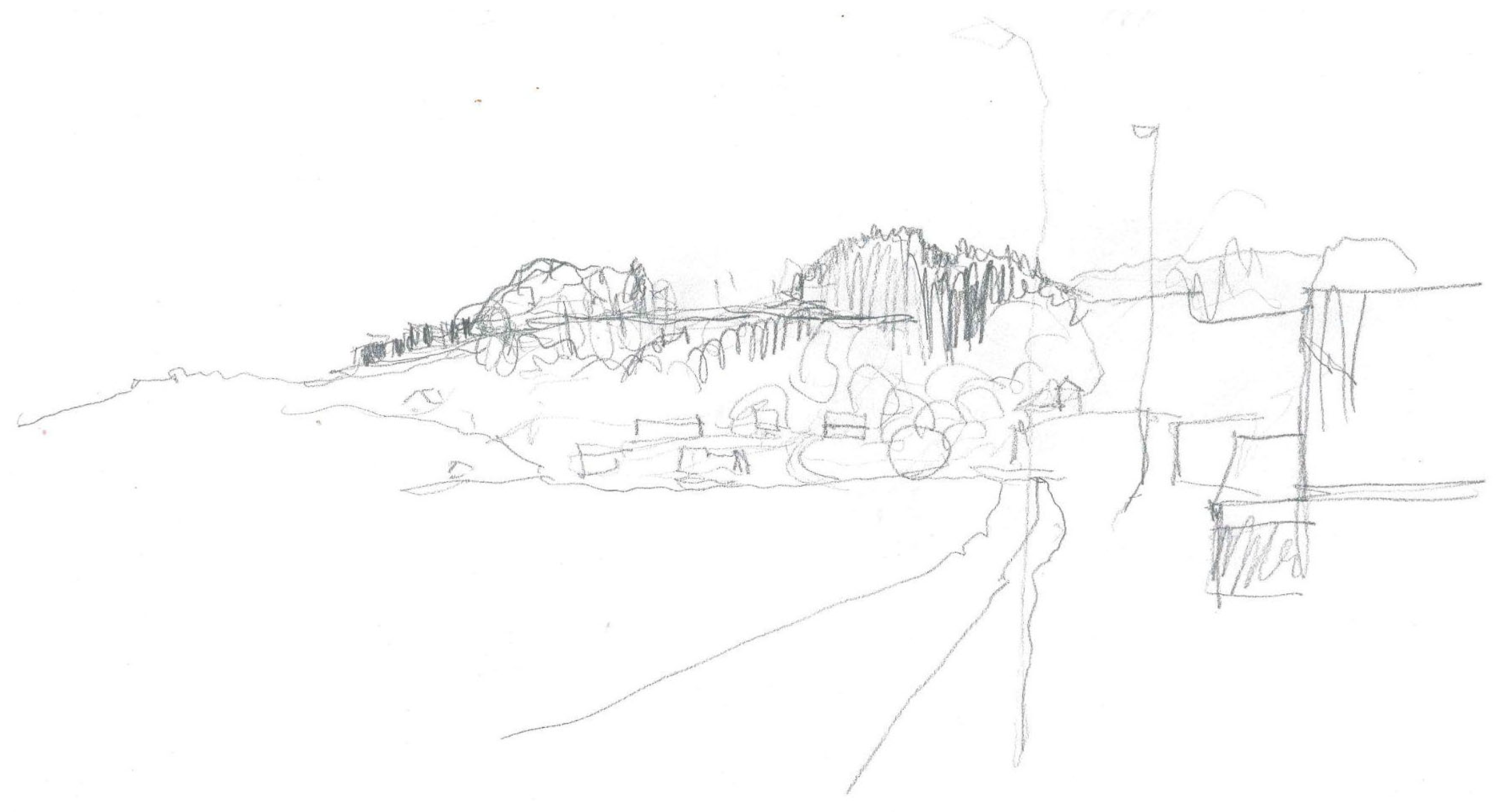
Drawing is employed as a tool beyond its mere aesthetic value of documenting a landscape’s beauty but as an instrument to capture the impact of local planning processes. For the landscape architect Ingfrid Lyngstad, drawing can become a documentation of “collective grief”. The negative changes enacted on specific landscapes symbolized the omitted parts of the participation process. Lyngstad used drawings as part of a case study to show what the characteristic elements were and how they were going through phases of change (see
Figure 6). In this case, the initial silhouettes set the basis for the narratives and values that appeared while studying these places [
13].
3.2.3. Portraying Places and Developing Narratives
For his films, Van Groeningen portrays specific locations by creating fictional places from his social and spatial knowledge of Flemish peri-urban spaces and medium-sized provincial cities. For instance, With Friends Like These records the emptiness of a medium-sized city in Flanders through squares, train platforms, parking lots, suburban areas, the position of apartment blocks, etc. Van Groeningen confronts neutral, grey, and empty portrayals of the urban environment in the present with flashy, colourful images of the past. Van Groeningen’s work is an example in which the chosen setting, in dialogue with the storyline, constructs a set of relationships that allow the viewer to build a certain type of knowledge about a place. These movies make it clear that regarding and analysing filmic representations as documentation instruments of places reveals information about these places and draws attention to otherwise overlooked places.
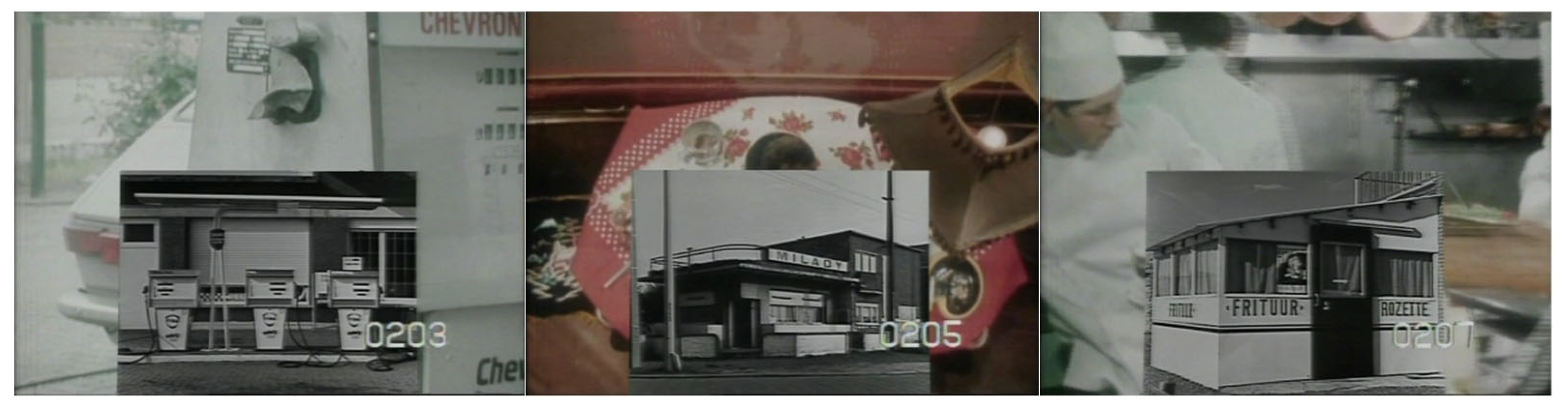
From a more traditional documentary approach, the work of Jef Cornelis explores the emerging landscapes of thriving urbanization. The documentary
Rijksweg N°1 from 1978 was based on a screenplay written by art and architecture theorist Geert Bekaert and broadcast on television. In seven chapters, the film highlights various aspects of the national roadway that connects Brussels to Antwerp between the bridge of Kontich and the bridge of Walem. The heavy traffic had come to a standstill at that time due to the arrival of the highway in the 1970s, leaving the landscape with a deserted appearance. Especially in the first chapters, the desolate atmosphere is emphasized by “silenced” images: figuratively, because there seems to be no trace of life, only a few people, and very sporadically, some traffic appears, but also literally, because there is no background music either. The human presence and background music gradually build up throughout the film. Despite this deserted atmosphere, this film creates a clear image of an arterial road with typical accompanying developments. The disordered edge, with its “
Villas—‘the prototype of the edge’—commercial buildings, gas stations, showrooms, brothels, roadside cafes, restaurants and homes [
21]”, is given extra attention in a separate chapter in the documentary (see
Figure 7). After the visual summary of what the edge of the road entails, attention is also paid to the signs—“
every building a sign that town or village does not exist [
21]”. By focusing on details such as flowerbeds, mailboxes, fences, and lowered shutters, the director emphasizes that there is no communal life along this road: “
The road is not a place, the road is a connection from one place to another [
21]”.
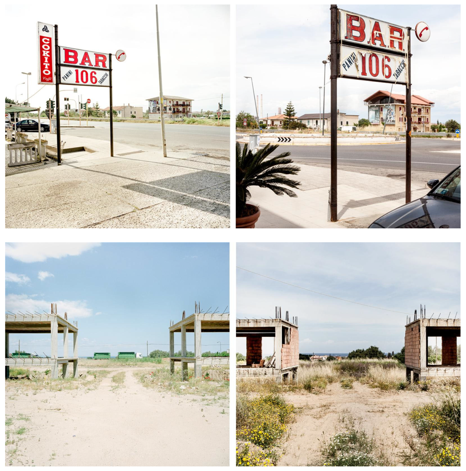
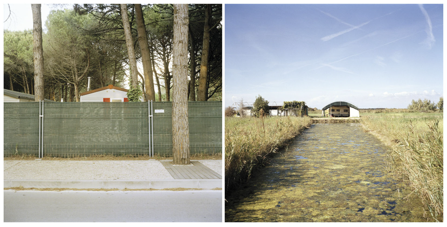
Filippo Romano’s
Statale 106 photographic project has been unconsciously outlined since his childhood, during numerous trips organized by his family to travel from Milan to Calabria and Sicily, the places of his ancestors. This project, an ongoing and perhaps never-ending personal assignment, started in 2007. Through
Statale 106, Romano documents and narrates the broken relationship between the South and the Italian government. It is a story about the “
promises, the half-promises, the failed industrial experiments [
29]” led by the national government in its attempt to create jobs and improve southern Italy’s living conditions [
29] (see
Figure 8).
For Romano, photography becomes a form of assessing and critically analysing conflicts’ social and political dimensions and how they are spatially revealed. His work depicts these Italian “new peripheries”, often portrayed only by maps built from data through geographic information systems. Romano’s work introduces an alternative cartography of a specific area through photographs. Romano aims for his work to be remembered as a neutral and observational gaze that contains personal “drifts” that are more poetic, reflecting curiosity and knowledge and his way of interpreting. He observes cities, and he documents them [
29].
3.2.4. A Creative Decision-Making Process
Documentation in drawing involves a “conscious” decision to carefully represent what you see and how you want to show it. The word “capture” is an active form of documenting, identifying an element before one draws it or attempts to recreate it. In drawing, documentation is the result of a personal decision-making process that entails observing, analysing, extracting, and representing a place through a drawing or a series of drawings. A drawing is the final output of a process that seeks to capture, interpret, and represent a place. Unlike documentary photography, which seeks to portray a precise or rather “
authentic representation of a place” [
37], drawing contains aspects guided more by emotions and technique and a process of selection and representation.
Like in photography and film, composition plays an essential role in the final outcome of the creative process. The act of composing not only impacts what is being documented but also influences how it is conveyed and portrayed. For instance, Véronique Simon [
14] describes drawing as a kind of extension of her mind, and through being present with the motif, the eye catches the shape of the landscape, the structure of the houses, details, materials, and context. For her, the choice of motif is not planned in advance, and it can describe the relationship between people and landscape. One of the challenges of documenting through drawing is how to negotiate with interpretation. Drawing is guided by choice and decisions. “
A problem can be that you start to fall in love with this landscape and that this mixes into the interpretation [
14]”. However, this time-devoting creative act allows the artist to get immersed deeper into the situation.
Interpretation, emotions, skills, and techniques guide the process of drawing. These aspects are both the limitations and the potential that drawing has for becoming a method for documenting a place. Although, at first glance, it reveals itself as less accurate, the work of these various artists reveals that drawing could effectively be used to identify the “forgotten” elements and qualities of landscapes and places that can later guide design and planning processes. The time needed to observe or the decision to choose a view reveals qualitative aspects of places, both of what is being observed and identified and from where it is being observed. Therefore, this way of documenting and experiencing a place can cohesively document a design process from the initial field visits that set the basis for later and more precise phases of planning and design.
3.3. Identification of Communicational Aspects
When artwork is made part of urban planning, the understanding of a complex site can be shared between experts and laypeople at an early stage. This enables exchanging knowledge about particular places as they are, their history, as a basis for discussing alternatives and visions for the future. This kind of communication requires establishing a setting where people are invited, on-site, in meetings or workshops, to contribute to telling the full narrative of a place. It should be made clear that the idea behind the artwork is not to just depict the site but to clarify its character and disclose its narratives. Since artworks possess the ability to transcend linguistic and cultural barriers, they serve as a powerful medium of communication, conveying ideas, narratives, and perspectives that resonate with individuals from diverse backgrounds. In some of the cases studied here, we found that the representations played a role in creating a dialogue with laypeople in planning processes. The information on site and with the inhabitants was also sometimes transferred to the professionals in a planning team. From there, dialogue with policymakers and stakeholders could happen. This communication was explored in the three different artistic methods of drawing, photography, and film.
3.3.1. Creating Dialogue with the Community
Landscape architects traditionally use drawings in public meetings as part of their practice. Nowadays, drawings are perceived as old-fashioned and not accurate enough. People tend to compare the value in the practitioner’s drawing with a “realistic” data model. Which one is easy for laypeople to understand, and is the expert’s interpretation of any value?
Architect professor Birgit Cold mentions how appreciation of sketches and drawings can be different for experts and laypeople, but that there are some general, common qualities: “
Order, coherence, and wholeness together with moderate complexity, variety and ‘mystery’ seem to be general environmental qualities [
16]”.
Therefore, the practitioner’s role is to give a personal interpretation that can be communicated to the audience using observation, experience, and knowledge. Now, the drawer makes a selection, as described in the analysis part, which is essential. The drawer can choose what details to show and what contours are needed to understand spatial perception. The drawing then includes the practitioner´s interpretation, as described by Cold. According to Simon, drawings also served as an initiator of dialogue. Showing one’s interpretation of their landscape can enlighten both the practitioner and the audience, as the practitioner unlocks the image of the everyday landscape for the inhabitant/stakeholder/policymaker at a site-specific level. Laypeople often admit to not seeing their daily surroundings as they get so used to them. The professionals’ drawings can be an artistic “gift” to the observer to start bringing forward their stories and what they value about this landscape. In Simon’s experience, she describes that when she asks the audience, “
What is important for you in this landscape [
14]?”—the question is followed by a moment of silence. After a while, somebody starts to talk about deeper values that take time to remember. The basic idea is that local people know much more about their everyday landscape than you as a drawer, professional spatial planner, and/or landscape architect [
14]. A dialogue must be mutual. First, the artist makes the drawing, listening to the motif; second, the artist listens to the laypeople.
In
Un hameau balcon Les Traverses de La Grave [
15], Simon underlines the attitudes and patience needed to communicate the drawing and unlock the values. The chosen work from photography and cinema also reveals values in the surroundings that had become less legible over time [
15]. In meetings and exhibitions, this may create curiosity, awareness, and clarity as additional information for plans and maps.
While images of all kinds have become readily accessible in today’s mediatized age, the realm of “authorship photography” is still primarily conveyed through temporary exhibitions and book publications. As a result, it is often less widely accessible, with only a limited selection of images from a specific photographic project being publicly accessible. Therefore, one of the challenges to integrating this type of photographic work into research and planning is enabling access to it. The role of archives and collections becomes more relevant in that context.
As shown by the photographers’ work in this paper, photographic narratives used for a project can be critical and active forms of looking at specific territories and complex socio-spatial phenomena. In Statale 106, Filippo Romano highlights a “gap” between the north and south of Italy as socially and economically interdependent regions. Francesco Secchi identifies and records “critical” and “fragile” spaces and possible areas for regeneration in the Lombardy region. As Francesco Secchi is professionally trained in urban planning, he employs photography as a method for observing and communicating about his area of focus. The current state of some of the everyday landscapes he records is employed as a general strategy to reveal some of the challenges that could be addressed by planning and policies. His images’ quality and careful composition give a more visual understanding of these spaces, carefully placed in dialogue with a spatial cartographical analysis of the territory. His work is positioned as a direct and carefully designed nexus between research and planning activities.
In meetings or presentations, laypeople’s reactions to the photographic work can be recorded as material for planning. This material should be easier to integrate with planning when the photographer is also a planner, like in Secchi’s case.
Films have the capacity to interact, contribute, and even influence public opinion. There are numerous examples of how cinema can initiate awareness and even influence people’s behaviour. The immediate impact of 2006′s
An inconvenient truth [
41]
, in which Al Gore portrays the consequences of “global warming”, was already the subject of several studies with varying results. Awareness about climate change after seeing the film translates into behavioural change and an increase in carbon offsets [
42,
43]. However, there are also examples of less positive effects. For instance, nature and especially the coral at Maya Bay beach on Thailand’s Koh Phi Phi Leh, world-famous for the film
The Beach [
44] starring Leonardo DiCaprio, suffered much damage due to years of intensive tourism, leading the authorities to decide to close the beach.
The outreach and impact of film are considerable. Films that try to understand everyday life could also create communication about a site in a planning project. Since films can assist in reinterpreting places and understanding emotional attachments to them, they represent a possibility for laypeople to react with emotions. It further allows comments about what is inhuman or unfair in these places. A possible way to discover the reception and appropriation of spatial perspectives is by organizing film sessions. After screening fragments of a selection of motion pictures to an audience of stakeholders, a panel discussion with an expert panel and the public could allow us to understand how films are able to communicate and even influence spatial concepts, views, and actions of stakeholders and shareholders of the subject. In order to discover the public’s reception and appropriation of spatial perspectives in film, an interactive questionnaire could allow participation before, during, and after the screening.
Within the context of doctoral research on the image of the Flemish urbanized landscape in film and how film can be used as a tool for spatial planning, two film sessions with debates were organized to explore the potential of film in this area. The first session focused on suburbia in film, while the second session centred on open space. The majority of the respondents (seventy-seven percent in the evening focusing on suburbia in film, a hundred percent in the evening centred on open space) were convinced that film might be regarded as a medium that can help planners or spatial experts in their reading and handling of open space in Flanders. They suggested implementing film mainly on a cultural level and in spatial education to gain insight into the experience of open space. Films enable us to sense the situation in a way that cannot be caught in regular plan analyses. On a cultural level, films can contribute to thought processes, dialogue, and even sensibilization with a broader audience [
4].
3.3.2. Fostering Communication within Planning Teams through Artworks
Simon talks about working with ideas in the transversal group of planners and how one can quickly summarize an idea or context in a 2D sketch that is easy for everybody in the project group to relate to and discuss [
14]. In her practice as a landscape architect, she experienced how realistic types of digital representations made by different software loosen the subtlety of ideas and observations and slow down the creative flow. The informal drawing can let ideas emerge for discussion and be excellent in interdisciplinary discussions. “
You can show what you think, words take so much more time [
14]”.
Various strategies exist for integrating photographic work into public projects and planning, as seen in diverse photographic campaigns led in Italy, France, and Belgium [
17,
38,
39,
40]. A notable recent example is Secchi’s work in Lombardy, in which he was involved in a multidisciplinary research team [
17]. Tailoring the incorporation of photography into the initial phases of planning processes is crucial and should be customized for each individual project. It is possible to include a professional photographer as a member of the research and planning team, although it is important to define a role in which photographers are given enough “artistic” freedom to contribute with a different and enriching perspective. In Filippo Romano’s project
Marea oggi marea domani for the Municipality of Cavallino Treporti, located in the Venice lagoon, he critically portrayed the transition from an agricultural-based economy to a summer touristic model that took over the natural complexity and uniqueness of this territory [
45] (see
Figure 9). As explained by Romano, his work contrasts with the type of commercial images commonly used in the tourism industry. In this project, he felt that he could objectively narrate the effects of tourism, even if this contrasted with the expectations of his commissioners [
29]. Romano aims for his work to become “stepping stones” for a project by provoking change, but he acknowledges that his role as a photographer is not to tell anyone how to do it.
To be able to read and understand peri-urban sprawl, most planners need to go beyond the systematic use of other research methods like GIS. Film itself has the capacity to interact between professional experts, or the system as defined by Habermas in his Theory of Communicative Action, and the everyday, the lifeworld [
46]. Van Groeningen’s directorial choices—the narratives he wanted to show by meticulously choosing the narrative and the setting—can be studied. By focusing on film, another way of thinking can be implemented, and eventually, the moving image can function as a medium to bridge the gap between professional experts and the everyday. Films enable us to sense the situation, which cannot be caught in regular plan analyses. On a cultural level, films can contribute to thought processes, dialogue, and even the sensibilization of a broader audience. This concept can inspire planners to approach peri-urban landscapes based on their specific characteristics and narratives.
If films can introduce a perspective to better understand everyday landscapes, especially peri-urban areas, film sessions with (panel) discussions, as described above, can be a way to implement film in planning processes. In these sessions, valuable information is given to a planning team; thus, the information can be interpreted further in the planning group. By using films that describe spatial journeys through peri-urban spaces, planning teams can benefit from a deeper understanding of the spatial coherence in or around a planning project [
4]. For example,
Steve+Sky provides another kind of empathy for these specific car-oriented landscapes by including the gaze of a human being inhabiting and experiencing these spaces.


