Article

Evaluation of Two Momentum Control Variable Schemes in Radar Data Assimilation and Their Impact on the Analysis and Forecast of a Snowfall Case in Central and Eastern China

1
China Meteorological Administration Basin Heavy Rainfall Key Laboratory, Hubei Key Laboratory for Heavy Rain Monitoring and Warning Research, Institute of Heavy Rain, China Meteorological Administration, Wuhan 430205, China
2
Key Laboratory of Meteorological Disaster, Ministry of Education (KLME), Joint International Research Laboratory of Climate and Environment Change (ILCEC), Collaborative Innovation Center on Forecast and Evaluation of Meteorological Disasters (CIC-FEMD), Nanjing University of Information Science & Technology, Nanjing 210044, China
3
China Meteorological Administration Tornado Key Laboratory, Guangzhou 52800, China
4
China Meteorological Administration Radar Meteorology Key Laboratory, Nanjing 210000, China
5
Anhui Atmospheric Observation Technology Center, Hefei 230000, China
6
Anhui Meteorological Observatory, Hefei 230000, China
*
Author to whom correspondence should be addressed.
Submission received: 11 January 2024 / Revised: 27 February 2024 / Accepted: 8 March 2024 / Published: 11 March 2024
(This article belongs to the Special Issue Data Assimilation for Predicting Hurricane, Typhoon and Storm)

Abstract

:
To evaluate the impact of different momentum control variable (CV) schemes (CV5, the momentum control variable option with ψχ and CV7, the momentum control variable option with UV) on radar data assimilation (DA) in weather research and forecasting model data-assimilation (WRFDA) systems, a heavy snowfall in central and eastern regions of China, which started on 6 February 2022, was taken as a case in this study. The results of the wind-field increments from the single observation tests indicated that the wind-field increments had a larger range of influence when stream function and velocity potential (ψχ) were used as momentum control variables in CV5. Some spurious increments were also generated in the wind-field analysis, since CV5 tended to maintain the integrated value of the wind field. When U-wind and V-wind were used as control variables in CV7, the wind-field increments had a smaller impact range, and there was less dependence among different locations on the wind increments. For the heavy snow case, the CV7 schemes displayed some improvements in simulating the composite reflectivity compared to the other two experiments, since the composite reflectivity in the CV5 and control experiments were overestimated to some level. It was also found that the RMSEs were lower in the CV7 compared to those in the CV5 in the short-term forecasts during the data-assimilation cycles. Results also indicated that the CV7 had a more significant effect on the 6 h accumulated precipitation forecasts. Meanwhile, the experiment Exp_CV7 achieved the best ETS and FSS scores among the three groups of experiments, while Exp_CV5 appeared to be generally superior to the CTRL. In summary, the precipitation of Exp_CV7 yielded the rainfall intensity and location most close to the observation compared to those from both the CTRL and Exp_CV5 experiments.

1. Introduction

Snowstorms are one of the most significant hazardous weather conditions during the winter. They is characterized by widespread, intense snowfall, accompanied by cold waves, strong winds, and a sudden drop in temperature. These phenomena pose a severe threat to agriculture, livestock farming, transportation, communication, and power supply, as well as people’s livelihoods, lives, and property. Due to the climatic characteristics in the southern regions of China, snowstorms may be accompanied by other cold-related weather disasters, such as freezing rain and snow, as a result of their impact.
In recent years, there have been studies employing various numerical simulation schemes for simulating snowstorms. Wang et al. [1] conducted a numerical forecast of a widespread heavy snowstorm event in northeastern China using a weather research and forecasting model (WRF) with five different microphysical parameterization schemes. Min et al. [2] conducted assimilation experiments for two different snowstorm events in South Korea using two kinds of radar data-assimilation methods: three-dimensional variational data assimilation (3DVAR) and the local ensemble transform Kalman filter (LETKF). The results of the two assimilation forecast experiments were analyzed from various aspects to evaluate their quality. Some studies have aimed to improve numerical simulations of snowy weather by investigating the microphysical mechanisms of snow. Huang et al. [3] used joint observations of a polarimetric radar and a disdrometer to explore the microphysical characteristics of two snowstorms over East China and tested the manifestation of specific differential phase (KDP)in the dendritic growth layer (DGL) in snowfall nowcasting.
It has been proved that radar data assimilation is an effective method of improving short to medium term numerical forecasting. The methods for radar data assimilation include 3DVAR [4,5], four-dimensional variational data assimilation (4DVAR) [6,7,8], ensemble Kalman filter assimilation (EnKF) [9,10,11], and hybrid assimilation methods [12,13,14,15]. The 3DVAR method is widely employed in operational forecasting and data-assimilation research due to its low computational cost and its high effectiveness in improving the model’s initial fields. It minimizes the cost function through iterative operations to obtain the optimal analysis [15]. It is necessary to obtain the background error covariance matrix (B) before conducting variational data assimilation. B can be estimated through statistical analysis using the National Meteorological Center (NMC) method [16]. Because the variational assimilation is based on Bayesian theory, it allows the use of ψχ as well as UV as momentum control variables in variational analysis. The WRF and WRFDA systems have developed the CV5 and CV7 options based on these two different control variables. However, Xie and MacDonald [17] pointed out that in 3DVAR using the CV5 scheme, the velocity needs to be converted into stream function and velocity potential by solving the Poisson equation. This process can lead to computational errors near the boundaries, which theoretically illustrates its limitations. The option of the CV7 scheme was updated in the WRFDA V3.7 in 2015.
The radar data-assimilation method is one of the important components in numerical forecasting assimilation experiments. Xiao et al. [18] developed a direct radar assimilation scheme for radar reflectivity data with the total water mixing ratio as the control variable. But the observation operator for radar reflectivity is a linear operator and is appropriate for warm-rain processes. Wang et al. [19] developed an indirect radar data-assimilation scheme for radar reflectivity. This method involves adjusting the model’s background fields by assimilating estimates of hydrometeors and water vapor, which are retrieved from radar reflectivity. This approach helps avoid the nonlinear nature of directly assimilating radar reflectivity and the significant errors introduced which can lead to an underestimation of hydrometeor analysis during the linearization process of the radar reflectivity observation operator. Building upon the existing model, Gao and Stensrud [20] developed a radar reflectivity forward operator that utilizes the background temperature field for automatic classification of hydrometeors. This has led to some improvements in addressing the issue of unrealistic estimates of hydrometeor mixing ratios.
Many studies have started from different weather cases and conducted assimilation forecast experiments using CV5 and CV7 schemes to compare the strength and weakness of these two schemes in regional numerical simulation forecasting. Sun et al. [21] conducted assimilation experiments using seven convective cases on the Rocky Mountain front and found that the correlation between U and V was significantly smaller than that between ψ and χ, suggesting that they can be treated as independent variables. In addition, the spatial correlation of the velocity obtained from the CV5 scheme was negative over long distances. For the CV5 scheme, the large length scale and small variance of the analysis increments often missed small-scale features. Li et al. [22] compared the performance of two control variable schemes using a squall line case. The results indicated that the radar radial velocity assimilation based on the UV control variable scheme significantly improved the mesoscale dynamic field under initial conditions. Conversely, the CV5 scheme resulted in discontinuous wind fields and unrealistic wind convergence/divergence, leading to a deterioration in the precipitation forecast. This has led to some improvement in addressing the issue of unrealistic estimates of hydrometeor mixing ratios. There are other studies that focused on analyzing the impact of different momentum control variable schemes on data assimilation using mesoscale or small-scale convection cases [23,24,25]. The results of these studies all indicate that assimilation experiments using the CV7 scheme yield better numerical simulations.
However, studies on radar data assimilation for snowstorms in the mid-latitude regions of China are relatively limited. In contrast to the strong convective precipitation in the summer, snowstorms in Chinese mid-latitude regions exhibit weaker convection but still have a certain level of hazardous impact. Therefore, this paper will discuss the impact of radar radial velocity and reflectivity assimilation on the China mid-latitude snowfall forecast based on different momentum control variables. The structure of the paper is as follows: Section 2 introduces the DA and scoring methods. Section 3 presents the radar data and the experimental settings. Section 4 discusses the results of experiments. Summary and conclusions are given in Section 5.

2. Data and Methods

2.1. Observations

The data assimilated in this study consisted of reflectivity and radial wind velocity observations from the S-band Doppler weather radar at the Huangshan Radar Station. The Huangshan Radar Station is located at the Dabie Mountains region. The radar’s observational range extends to 230 km, and it employs the VCP21 (Volume Cover Pattern 21) observation mode for continuous volume scanning [22]. The radial wind speed error and the reflectivity error of radar data were 2 m/s and 5 dBZ, respectively. The observational data were derived from daily timed data from automated weather stations in China Meteorological Administration (CMA), which include hourly observational values of such weather elements as temperature, pressure, relative humidity, moisture pressure, wind, and precipitation.

2.2. Methodologies

2.2.1. 3DVAR DA Method

The cost function of three-dimensional variational assimilation is defined as follows:
J x = 1 2 ( x x b ) T B 1 x x b + 1 2 ( y o H ( x ) ) T R 1 ( y o H ( x ) )
where x is analysis field value, x b is the initial background field value, y o is the observed input value, B and R represents the background and observation error covariance matrices, respectively, and H is the observation operator that maps analysis or background variables from model space to observation space. B is commonly a huge matrix, and its inverse B−1 is difficult to compute. Hence, the matrix decomposition (B = UUT) is utilized to simplify the computation. U is decomposed background matrix. Through the decomposition of matrix B, the transformation can be obtained as Uv =  x x b . Therefore, Equation (1) can be transformed in to Equation (2):
J v = 1 2 v T v + 1 2 ( d H U v ) T R 1 ( d H U v )
Nowadays, the two momentum control variable schemes are frequently used in data-assimilation systems. The CV5 option utilizes stream function (ψ) and unbalanced velocity potential (χ) as its momentum control variables. The ψ and χ are integral of the dot product of the corresponding the velocity components U and V in the model grid. The relationship between these two sets of momentum control variables can be expressed by the following equation:
u = ψ y + χ x ,   v = ψ x + χ y
For the CV7 option, the velocity components U and V can be directly used as its momentum control variables. Sun et al. [22] pointed out that the correlation between U and V is not significant, as compared to that between ψ and χ.

2.2.2. Radar Observation Operator

Xiao et al. [26] converted the model wind variable into Doppler radial velocity in 3DVAR for assimilating Doppler radar radial wind velocity.
V r = u x x i r i + v y y i r i + ( w v T ) z z i r i
where V r is the Doppler radar radial wind velocity, ( u , v , w ) are the model wind components, ( x , y , z ) are the radar locations, ( x i , y i , z i ) are the radar observation data locations, r i is the distance between the radar location and observation point, and v T is the terminal velocity of precipitation particles. The terminal velocity ( v T ) can be calculated from the study by Sun et al. [27]:
v T = 5.4 a · q r 0.125
where q r is the rain water mixing ratio and a is correctional term calculated as follows:
a = ( p 0 p ¯ ) 0.4
where p 0 is the ground pressure and p ¯ , is the average pressure.
Because the radar does not directly observe water vapor, Wang et al. [19] proposed an improved method for the water vapor amount based on empirical relationships between relative humidity and radar reflectivity. This scheme assumes that when the reflectivity observed above the cloud base exceeds a certain threshold, and that the water vapor amount ( q v ) in that region is saturated ( q s ). In this paper, a reflectivity threshold of 25 dBZ was set, and the relationship is as follows:
q v = q s · 100 %
In the WRF-3DAVAR 4.1.2 system used, the inversion of hydrometeors and estimation of water vapor are separated switches. To assimilate the computation of each hydrometeor variable (rain water/snow/hail) and saturated water vapor, terms for hydrometeor-related J r / s / h and water-vapor-related Jv are added to the cost function.
J = J b + J o + J r / s / h + J v
where Jb represents the background term, Jo represents the observation term, and J r / s / h is the sum of the cost functions for hydrometeor variables. In this study, the reflectivity forward operator for automatic classification of hydrometeors proposed by Gao and Stensrud [20] was applied using the background temperature field.

2.2.3. Verification Methods

The equitable threat score (ETS) was used as a test for precipitation forecasting in the study. This means a perfect forecast when ETS is equal to 1. Conversely, when ETS is less than or equal to 0, it means the forecast is useless. The formula is as follows:
E T S = a a r a + b + c a r
where a denotes the number of points where both the forecast and observation are greater than or equal to a threshold. b stands for the number of points where the forecast is above a threshold whereas the observation is under the same threshold. c stands for the number of missing forecasts. αr is the expected number of correct forecasts above the threshold in a random forecast where forecast occurrence/non-occurrence is independent from observation/non-observation. a r is calculated as follows:
a r = a + b · ( a + c ) ( a + b + c + d )
where d is occasions where both forecast and observation are under the threshold.
Roberts and Lean [28] illustrated a new scoring method referred to as fractions skill score (FSS) for forecasts. The FSS can be used to assess the accuracy of precipitation forecasts.
F S S = 1 1 N N ( P i O i ) 2 1 N ( N P i 2 + N O i 2 )  
where N is the number of horizontal grid points, P i is the precipitation in model’s prediction field, and O i is the precipitation in observation field.

3. Experimental Design and Case Overview

3.1. Model Configuration and Experiment Design

WRF version 4.1.3 (ARW) [29], developed by National Center for Atmospheric Research (NCAR), was used in this study. As shown in Figure 1, the model domain consists of single grid with resolutions of 3 km. The model’s initial condition and boundary condition are provided by the National Center for Environmental Prediction (NCEP). Final analysis (FNL) data on 1-degree by 1-degree grids is prepared operationally every six hours. The model has a horizontal grid of 701 × 701 grid points, 35 vertical layers distributed inhomogeneously, 4 soil layers, and 50 hPa pressure for the top layer.
This study used the WRF double-moment six-class scheme (WDM6) [30] for grid scale microphysical processes. The rapid radiative transfer model (RRTM) [31] was used for long-wave radiation, and the Dudhia scheme was used for short-wave radiation [32]. The cumulus parameterization scheme was turned off. The Yonsei University planetary boundary layer scheme (YSU PBL) [33], the revised MM5 Monin–Obukhov surface process scheme [34], and the unified Noah land surface model [35] were used in model physics.
As shown in Table 1, the experiments were divided into three groups. The simulation experiment conducting DA is referred to as CTRL. The other two sets of experiments are categorized as Exp_CV5 and EXP_CV7 due to differences in the control variables for background error covariance matrix B. The B was calculated using the National Meteorological Center (NMC) method, considering 12 h and 24 h forecasts of winter periods (1 February 2022–21 February 2022). The B file was derived based on these forecast samples. For Exp_CV5, the control variables of B included the stream function, unbalanced velocity potential, unbalanced temperature, pseudo relative humidity, and unbalanced surface pressure. On the other hand, the U-wind and V-wind components, temperature, pseudo relative humidity, and surface pressure were utilized in EXP_CV7.
The processes of the three experiments are depicted in Figure 2. The CTRL made a 30 h prediction from 0600 UTC on 6 February 2022 to 1200 UTC on 7 February 2022. The DA experimental groups commenced at 0600 UTC on 6 February 2022, with an initial 6 h prediction. Between 1200 UTC and 1800 UTC on 6 February 2022, radar data assimilation was conducted seven times before creating an 18 h prediction field. Surface and upper-air conventional observational data from NCAR were incorporated into assimilation at the beginning and end moment of each assimilation cycle.

3.2. Synoptic Overview

From 12:00 UTC on 6 February 2022 to 12:00 UTC on 7 February 2022, Anhui Province experienced rainy and snowy weather, with the majority of precipitation occurring in the southern region. Some monitoring stations recorded a maximum snow depth of up to 28 cm, and the 24 h maximum cumulative precipitation reached 29 mm. This was an infrequent occurrence of heavy snowfall for the eastern part of China. To provide reference for the simulation and forecasting of such snowstorm events, this study conducted cycling assimilation and forecasting experiments for radar data using two different control variable schemes within the WRFDA system.
Figure 3 depicts the atmospheric background conditions during the snowfall event. At 0600 UTC on 6 February 2022, at 500 hPa (Figure 3a), there was a low-pressure trough over Northeast China and North China, with a blocking high-pressure system upstream over the western part of the Mongolian Plateau. These two systems remained stable, resulting in the southward movement of cold air along the line from Lake Baikal to the Taihang Mountains. At lower latitudes, the trough over the Bay of Bengal showed an eastward shift and deepening trend, indicating the future strengthening of warm and moist airflow.
At 850 hPa (Figure 3b), there was a southwest warm and moist airflow from the Indian Ocean and a southward warm and moist airflow from the South China Sea, providing the moisture conditions for this snowfall event. Weak cold air was entering northern Anhui, facilitating moisture condensation. Meanwhile, the cyclonic circulation pattern located upstream in the Chongqing region showed an eastward trend, which was expected to impact the Anhui region and intensify the snowfall.
The Anqing station is located to the northwest of the Huangshan Radar Station within the radar detection range. Figure 4a shows the radiosonde profiles of the Anqing station at 1200 UTC 6 February 2022. It can be observed that the atmospheric circulation background involved the ascent of warm and moist air at 700 hPa over a cold underlying surface at 850 hPa at this moment. Also, the temperature was below 0 °C at altitudes above 300 m over the Anqing station; temperature below 700 hPa equals the dew point temperature. This indicates that favorable temperature conditions had been established for the formation of snow in the ground layer. It can also be seen that the lower atmosphere contained ample moisture, conducive to the formation of snow. Figure 4b displays the simulation results of temperature, humidity, and wind fields in the CTRL experiment, which closely matched the observations in the altitude below 500 hPa. This suggests that the CTRL experiment simulated the atmospheric circulation background in this region very well, providing a good background field for the upcoming radar assimilation experiment.

4. Result

4.1. Comparison of the Background Error Statistics

The features of the background error covariances are illustrated based on the two control variable schemes used in the DA experiments. The statistics of eigenvalue and length scale of the matrix B were assumed to vary only with height. The eigenvalues of U (V) and ψ (χ) were normalized by using the first mode of empirical orthogonal function. The magnitude of eigenvalues reflected the contribution to the variance of vertical modes. In Figure 5a,b, the eigenvalues decrease with an increase in vertical modes, indicating a more significant impact at lower modes. From Figure 5a, it can be observed that the eigenvalues of ψ decrease more rapidly than those of U. For χ and V, the eigenvalues of χ are larger than those of V in the first 12 modes. But from the twelfth mode, the opposite trend is observed. Figure 5c,d illustrates that the length scales of ψχ and UV decrease with an increase in modes, indicating that the effects were more significant in the low modes compared to the high modes. Meanwhile, the length scale of ψχ is larger than those of UV, and the ratio of ψ/U and χ/V increases slightly with the increase in modes, indicating that the response of ψ-χ control variables was wider.

4.2. Single Observation Tests

Prior to conducting real radar data-assimilation cycling experiments, an idealized single wind observation test (Figure 6) and a radar radial wind observation test (Figure 7) were conducted to better understand the impact of different momentum control variables on the wind-field analysis. In the idealized single observation test, an eastward wind innovation (observation background) of 1 m·s−1 was assimilated at the 13th layer of the model. For the single radar radial wind observation assimilation test, the value of the observation was 10.697 m·s−1 located at (30.515° N, 118.941° E, 3001 m) northeast of radar. The forecast field of the CTRL at 1200 UTC 6 February was used as the background field.
Figure 6a,c illustrates the increment of the U-wind for CV5 and CV7 at the 13th layer of the model. In both experiments, the increment of the U-wind was maximized near the observation point. But the increment range of the CV5 was much larger than that of the CV7. Figure 6a shows that the opposite velocity took place near the region of positive U-wind increment, which is not present in Figure 6c. Figure 6b,d demonstrates that the impact of U-wind observations on V-wind increments varied among different CV options. Figure 6b indicates that U-wind observation had a certain impact on V-wind increments in the CV5 option, while in the CV7 option, there was no such impact (shown as no values in Figure 6d). This eastward wind innovation contributed directly to the U-wind increment. When assimilating the U-wind, the smaller V-wind increment also existed due to the correlation between the climatological balance parts of the control variables ψ and χ in CV5. Since the innovation added was the eastward wind component, it primarily affected the U-wind, while its impact on the V-wind was minor. Conversely, the U-wind component did not have an effect on the V-wind, since the UV momentum control variables were uncorrelated.
While the U-wind and V-wind relied on an observation operator to transform them into the Vr field, Figure 7 displays similar results to those in Figure 6. As expected, Figure 7 shows that the U-wind increment (Figure 7a,c) was greater than the V-wind increment (Figure 7b,d), since the values of U-wind derived from radar radial winds were larger than those of V-wind at the selected observation point.

4.3. Wind Increment

The wind increments are presented to show the effect of different wind control variables after completing the first assimilation process. The radar radial wind and surface and upper air observational wind data were assimilated in the process. Figure 8 shows the different wind increments of the two schemes at geopotential altitudes of 850 hPa, 700 hPa, and 500 hPa for 1200 UTC on 7 February 2022. Both sets of experiments exhibited significant wind-field increments within the radar detection range. However, the wind-field increments at the 850 hPa level were small, particularly in Exp_CV7, where the difference was more pronounced. This may be attributed to the higher elevation of the radar location, which was above 1800 m, resulting in limited wind-field information available for assimilation at this geopotential height. It can also be observed that the impact of the wind-field increment for Exp_CV5 was larger than that of Exp_CV7. This was due to the different characteristic length scales between them. Since the smoothing effect of stream function and velocity potential enlarge the length scale, the increment range of the wind field was larger in the Exp_CV5 than in Exp_CV7. Compared to Exp_CV5, the increment distribution in Exp_CV7 was reasonable. This scheme, which uses U-wind and V-wind as momentum control variables, to some extent ensures that after radar data assimilation, it can generate small- and medium-scale perturbations within the radar detection range while preserving the original large-scale balance in the background field. Additionally, the noticeable southward wind increments of Exp_CV7 were generated to the southeast of the radar station (Figure 8e), which was conducive to the transport of moisture from the coastal areas to the inland regions. This could potentially have improved the forecast for this rain and snow event. Since the stream function and velocity potential are essentially the integrated values of the U-wind and V-wind, they possess the property of maintaining horizontal wind integral values [24]. This characteristic may introduce some non-physical errors into their analysis increment field [17], resulting in the presence of false cyclonic or anticyclonic in the analysis increment field.

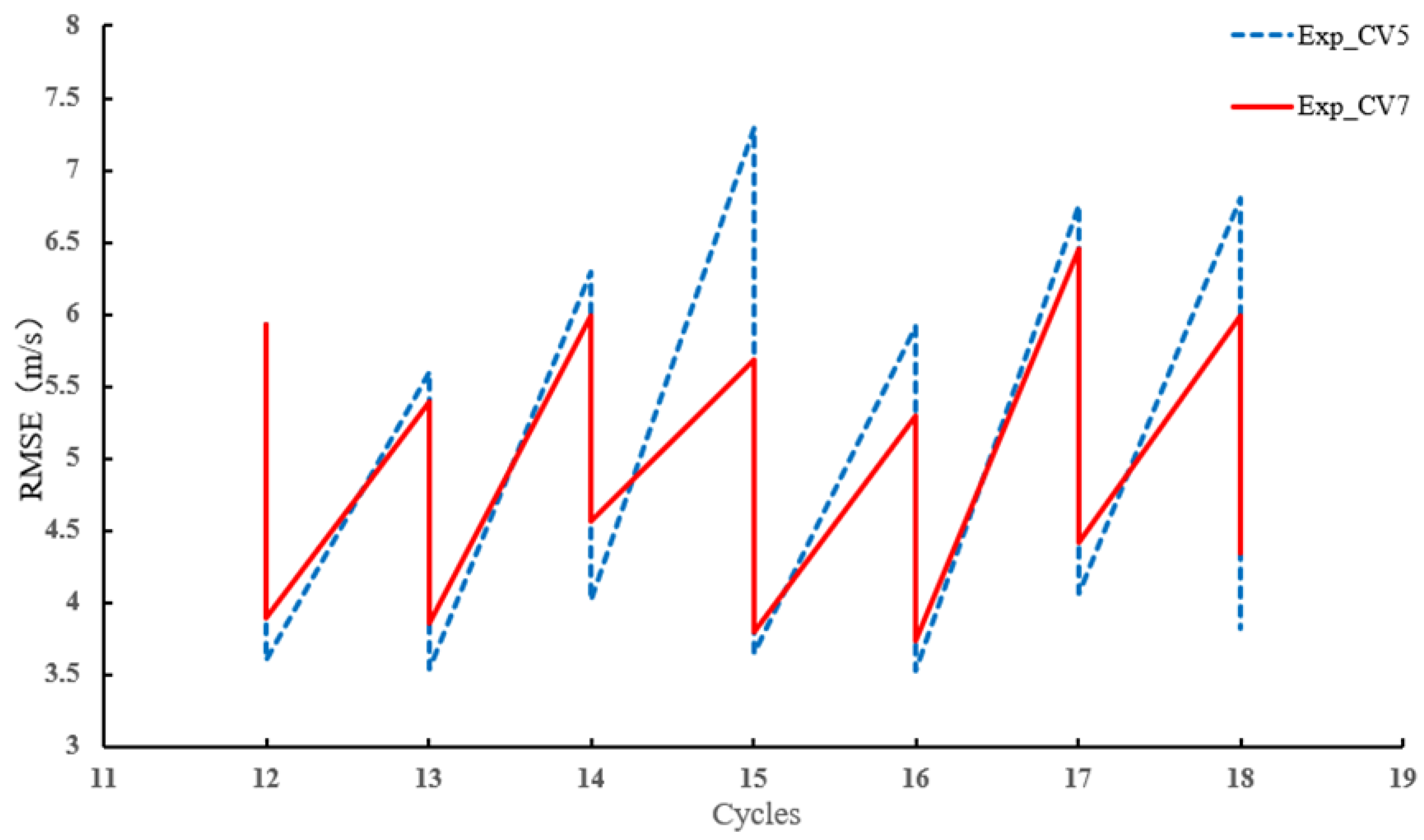
4.4. Analyses during DA Cycles

Root mean square error (RMSE) was used to measure the deviation between the observed and simulated values. Figure 9 illustrates the changes in the RMSE of radar radial wind velocity within the radar detection range during seven data-assimilation cycles. As shown in the Figure 9, it can be observed that RMSEs for both sets of experiments were significantly decreased to below 4 m/s in most of assimilation cycles after radar data assimilation. Meanwhile, the RMSE obtained from Exp_CV5 after every data assimilation was slightly lower than that obtained from Exp_CV7. However, after the forward forecast, the RMSE before data assimilation from Exp_CV5 was higher than that from Exp_CV7. In general, Exp_CV7 had better manifestation in the wind-prediction field compared to Exp_CV5, which is considered more important for forecasting.
Figure 10 shows a comparison of composite reflectivity between the three experiments and the observations. The radar observations reflected a distinct characteristic of stratiform precipitation with weak echoes under 30 dBZ in most of the radar-observed areas, although in all three sets of experiments, it was evident that simulated reflectivity was generally overestimated. There may be have been certain deficiencies when classifying the hydrometeor phases using the empirical formulas that were based on temperature, leading to an overestimation of hydrometeors associated with higher reflectivity, and thus resulting in an overall overestimation of composite reflectivity. But the two data-assimilation experiments still resulted in some improvement in radar reflectivity simulations. Compared to the experiment CTRL (Figure 10b), Figure 10d shows evident weak echoes (below 20 dBZ) in the southeast part of Anhui, and Figure 10c reveals some new weak echoes (below 20 dBZ) in Zhejiang and the southern part of Anhui.

4.5. Forecasts

Following the data-assimilation cycles, a 12 h forecast was conducted starting from 18:00 UTC on 6 February 2022. Figure 11 displays the 6 h accumulated precipitation distribution from observation and the three sets of experiments. The observed data were obtained by interpolating the station data from CMA to grid points using the Kriging interpolation method. In comparison to the observation, the precipitation distribution in all three sets of experiments closely resembled that of observation. The three experiments all exhibited the characteristics of stratiform precipitation with a central rainband that extended from the southwest to the northeast, where the precipitation was more significant in the center and lighter on the sides. Compared to the CTRL, the two assimilation experiments showed some differences in their simulation performance in the large precipitation regions with enhanced rainfall intensity. It was also found that the precipitation of Exp_CV7 yielded increased precipitation by 2–4 mm in the rainfall center with the rainfall intensity and location most close to the observation compared to both the CTRL and Exp_CV5 experiments. The underestimation of the rainfall intensity in the precipitation center was most obvious in the CTRL. In general, Exp_CV7 tended to exhibit a precipitation distribution that was closer to the observation compared to the other two experiments.
Figure 12 displays the hourly precipitation ETS and FSS scores for a total of 6 h using different scoring methods to evaluate the simulation results. The precipitation threshold used for scoring was 2 mm, where grid points with precipitation above 2 mm were considered as hits. The scores for all three sets of experiments, in general, increased with the simulation time. Both scoring methods showed that the hourly precipitation scores for the first 6 h indicated that the simulation results of Exp_CV7 were generally better than the other two groups of experiments. It should be noted that the precipitation simulation of Exp_CV5 in Figure 11c exhibits a southward bias in the location of intense rainfall bands and an overestimation of intensity. Additionally, the simulated precipitation over central Jiangxi appears weaker. Therefore, these discrepancies in simulation at these two locations may have contributed to the lower scores compared to the CTRL experiment.

5. Summary and Conclusions

Based on the WRF-3DVar system, this study evaluated two momentum control variable schemes in radar data assimilation and their effects on analysis and forecast for the snowfall case that occurred on 6 February 2022. Before the data-assimilation cycles, the background error statistics were evaluated under the two control variable schemes. Some preliminary results are as follows:
The eigenvalues of the two schemes were larger in the middle and lower modes, and the length scale was significantly larger for the CV5 scheme than the CV7 scheme. The single observation tests showed that assimilation results using ψχ control variables had a larger impact range on the wind field compared to those using UV control variables. In the CV5 scheme, the appearance of the U-wind increment had a certain impact on the V-wind field, while the CV7 scheme did not exhibit this characteristic. Similar to the results of the single observation tests, the wind-field increments generated from Exp_CV5 indicated that the momentum control variables used in the CV5 scheme had influenced the large-scale wind fields, and these wind-field increments manifested in the form of cyclones or anticyclones. In contrast, the wind-field increments in Exp_CV7 were more concentrated within the radar detection range, and there was less dependence among different locations on the wind increments. Moreover, the momentum control variables of the CV5 scheme maintained the integrated value of the wind field, resulting in the generation of false increments.
It should be noted that the composite reflectivity in all experiment analyses was overestimated to some extent. After the data-assimilation cycles, the CV7 data-assimilation experiments showed some improvement in the composite reflectivity field compared to the other two experiment. For CV7, the adjustment of the radar composite reflectivity was more significant. From a precipitation forecasting perspective, both the data-assimilation experiments, overall, showed relatively good manifestation in terms of the rainfall intensity, although the location deviation still existed. The precipitation of Exp_CV7 yielded the rainfall intensity and location most close to the observation compared to both the CTRL and Exp_CV5 experiments. The underestimation of the rainfall intensity in the precipitation center was most obvious in the CTRL. Compared to Exp_CV5, Exp_CV7 achieved higher precipitation scores. The precipitation forecast results indicated that Exp_CV7 showed better simulation manifestation. In future work, we will consider applying dual-polarization radar data to enhance the model’s classification of hydrometeors, thereby improving the simulation of snow echoes.

Author Contributions

Conceptualization, F.S.; writing—original draft preparation, S.W. and F.S.; writing—review and editing, S.W. and F.S.; formal analysis, S.W., J.C. and L.L.; software, J.C.; resources, D.D. and Z.H.; data curation, Z.H. All authors have read and agreed to the published version of the manuscript.

Funding

This research was primarily supported by the Chinese National Natural Science Foundation of China (G42192553), the China Meteorological Administration Tornado Key Laboratory (TKL202306), the Open Grants of China Meteorological Administration Radar Meteorology Key Laboratory (2023LRM-B03), the Open Project Fund of China Meteorological Administration Basin Heavy Rainfall Key Laboratory (2023BHR-Y20), the Program of Shanghai Academic/Technology Research Leader (21XD1404500), the Shanghai Typhoon Research Foundation (TFJJ202107), the Chinese National Natural Science Foundation of China (G41805070), the Natural Science Fund of Anhui Province of China under grant (2308085MD127), the Natural Science Foundation of Hubei Province (2022CFB025), and the Meteorological Union Fund of the Natural Science Foundation of Anhui Province of China (2208085UQ05).

Institutional Review Board Statement

Not applicable.

Informed Consent Statement

Not applicable.

Data Availability Statement

NCEP ADP Global Surface Observational Weather Data are available at https://rda.ucar.edu/datasets/ds461.0/ (accessed on 8 April 2023), NCEP ADP Global Upper Air Observational Weather Data are available at https://rda.ucar.edu/datasets/ds351.0/ (accessed on 8 April 2023), and the NCEP FNL for numerical simulations were obtained from https://rda.ucar.edu/datasets/ds083.2/ (accessed on 22 February 2023).

Acknowledgments

We acknowledge the High Performance Computing Center of Nanjing University of Information Science & Technology for their support of this work.

Conflicts of Interest

The authors declare no conflicts of interest.

References

  1. Wang, S.; Ping, F.; Meng, X.; Li, Y. Numerical Simulation of a Large-Scale Snowstorm Process in Northern China Using Different Cloud Microphysical Parameterization Schemes. Chin. J. Atmos. Sci. 2022, 46, 599–620. (In Chinese) [Google Scholar]
  2. Min, K.-H.; Chung, K.-S.; Lee, J.-W.; You, C.-R.; Lee, G. Intercomparing radar data assimilation systems for ICE-POP 2018 snowfall cases. Geosci. Model Dev. Discuss. 2022, 1–32. [Google Scholar] [CrossRef]
  3. Huang, H.; Tao, R.; Zhao, K.; Wen, L.; Chu, Z. Potential of snowfall nowcasting using polarimetric radar data and its link to ice microphysics: Study of two snowstorms in East China. J. Geophys. Res. Atmos. 2023, 128, e2022JD037654. [Google Scholar] [CrossRef]
  4. Gao, J.; Xue, M.; Shapiro, A.; Droegemeier, K.D. A variational method for the analysis of three-dimensional wind fields from two Doppler radars. Mon. Weather Rev. 1999, 127, 2128–2142. [Google Scholar] [CrossRef]
  5. Xu, D.; Shen, F.; Min, J. Effect of background error tuning on assimilating radar radial velocity observations for the forecast of hurricane tracks and intensities. Meteorol. Appl. 2020, 27, e1820. [Google Scholar] [CrossRef]
  6. Talagrand, O.; Courtier, P. Variational assimilation of meteorological observations with the adjoint vorticity equation I: Theory. Q. J. R. Meteorol. Soc. 1987, 113, 1311–1328. [Google Scholar] [CrossRef]
  7. Sun, J.; Flicker, D.W.; Lilly, D.K. Recovery of three-dimensional wind and temperature fields from single Doppler radar data. Atmos. Sci. 1991, 48, 876–890. [Google Scholar] [CrossRef]
  8. Sun, J.; Wang, H. Radar data assimilation with WRF-4DVar: Part II. Comparison with WRF-3DVar. Mon. Weather Rev. 2013, 141, 2245–2264. [Google Scholar] [CrossRef]
  9. Zhang, F.; Snyder, C.; Sun, J. Impacts of initial estimate and observation availability on convective-scale data assimilation with an ensemble Kalman filter. Mon. Weather Rev. 2002, 132, 1238–1253. [Google Scholar] [CrossRef]
  10. Xu, X.; Liu, L.; Zheng, G. Numerical Experiment of Assimilation of Doppler Radar Data with an Ensemble Kalman Filter. Chin. J. Atmos. Sci. 2006, 30, 712–728 (In Chinese). (In Chinese) [Google Scholar]
  11. Snook, N.; Xue, M.; Jung, Y. Multiscale EnKF assimilation of radar and conventional observations an ensemble forecasting for a tornadic mesoscale convective system. Mon. Weather Rev. 2015, 143, 1035–1057. [Google Scholar] [CrossRef]
  12. Li, Y.; Wang, X.; Xue, M. Assimilation of radar velocity data with the WRF hybrid ensemble-3DVAR system for the prediction of hurricane Ike (2008). Mon. Weather Rev. 2012, 140, 3507–3524. [Google Scholar] [CrossRef]
  13. Gao, J.; Stensrud, D.J. Some observing system simulation experiments with a hybrid 3DEnVAR system for storm-scale radar data assimilation. Mon. Weather Rev. 2014, 142, 3326–3346. [Google Scholar] [CrossRef]
  14. Shen, F.; Xu, D.; Xue, M.; Min, J. A comparison between EDA-EnVar and ETKF-EnVar data assimilation techniques using radar observations at convective scales through a case study of Hurricane Ike (2008). Meteorol. Atmos. Phys. 2018, 130, 649–666. [Google Scholar] [CrossRef]
  15. Courtier, P.; Thepaut, J.N.; Hollingsworth, A. A strategy for operational implementation of 4D-Var, using an incremental approach. Q. J. R. Meteorol. Soc. 1994, 120, 1367–1387. [Google Scholar]
  16. Parrish, D.F.; Derber, J.C. The National Meteorological Center’s spectral statistical-interpolation analysis system. Mon. Weather Rev. 1992, 120, 1747–1763. [Google Scholar] [CrossRef]
  17. Xie, Y.; MacDonald, A.E. Selection of momentum variables for a three-dimensional variational analysis. Pure Appl. Geophys. 2012, 169, 335–351. [Google Scholar] [CrossRef]
  18. Xiao, Q.; Sun, J. Multiple-radar data assimilation and short-range quantitative precipitation forecasting of a squall line observed during IHOP. Mon. Weather Rev. 2007, 135, 3381–3404. [Google Scholar] [CrossRef]
  19. Wang, H.; Sun, J.; Fan, S. Indirect assimilation of radar reflectivity with WRF 3D-Var and its impact on prediction of four summertime convective events. J. Appl. Meteorol. Climatol. 2013, 52, 889–902. [Google Scholar] [CrossRef]
  20. Gao, J.; Stensrud, D. Assimilation of reflectivity data in a convective-scale, Cycled 3DVar framework with hydrometeor classification. Atmos. Sci. 2012, 69, 1054–1065. [Google Scholar] [CrossRef]
  21. Sun, J.; Wang, H.; Tong, W.; Zhang, Y.; Lin, C.-Y.; Xu, D. Comparison of the impacts of momentum control variables on high-resolution variational data assimilation and precipitation forecasting. Mon. Weather Rev. 2016, 144, 149–169. [Google Scholar] [CrossRef]
  22. Li, X.; Zeng, M.; Wang, Y.; Wang, W.; Wu, H.; Mei, H. Evaluation of two Momentum Control Variable Schemes and their Impact on the Variational Assimilation of Radar Wind Data: Case Study of a Squall Line. Adv. Atmos. Sci. 2016, 33, 1143–1157. [Google Scholar] [CrossRef]
  23. Lu, C.; Chen, Y.; Meng, D. Comparative analysis of two dynamical control variables and their impacts on typhoon assimilation and prediction. Trans. Atmos. Sci. 2019, 42, 916–925. [Google Scholar]
  24. Xu, D.; Yang, G.; Wu, Z.; Shen, F.; Li, H.; Zhai, D. Evaluate Radar Data Assimilation in Two Momentum Control Variables and the Effect on the Forecast of Southwest China Vortex Precipitation. Remote Sens. 2022, 14, 3460. [Google Scholar] [CrossRef]
  25. Shen, F.; Song, L.; Li, H.; He, Z.; Xu, D. Effects of different momentum control variables in radar data assimilation on the analysis and forecast of strong convective systems under the background of northeast cold vortex. Atmos. Res. 2022, 280, 106415. [Google Scholar] [CrossRef]
  26. Xiao, Q.; Kuo, Y.; Sun, J.; Lee, W.-C.; Lim, E.; Guo, Y.; Barker, D.M. Assimilation of Doppler radar observation with a regional 3DVar system: Impact of Doppler velocities on forecasts of a heavy rainfall case. J. Appl. Meteorol. 2005, 44, 768–788. [Google Scholar] [CrossRef]
  27. Sun, J.; Crook, N. Dynamical and microphysical retrieval from Doppler radar observations using a cloud model and its adjoint. Part I: Model development and simulated data experiments. J. Atmos. Sci. 1997, 54, 1642–1661. [Google Scholar] [CrossRef]
  28. Roberts, N.M.; Lean, H.W. Scale-selective verification of rainfall accumulations from high-resolution forecasts of convective events. Mon. Weather Rev. 2008, 136, 78–97. [Google Scholar] [CrossRef]
  29. Skamarock, W.C.; Klemp, J.B.; Dudhia, J.; Gill, D.O.; Barker, D.; Duda, M.G.; Huang, X.; Wang, W.; Powers, J.G. A Description of the Advanced Research WRF Version 3; NCAR Technical Notes; UCAR: Boulder, CO, USA, 2008. [Google Scholar]
  30. Lim, K.-S.S.; Hong, S.-Y. Development of an effective double-moment cloud microphysics scheme with prognostic cloud condensation nuclei (CCN) for weather and climate models. Mon. Weather Rev. 2010, 138, 1587–1612. [Google Scholar] [CrossRef]
  31. Mlawer, E.J.; Taubman, S.J.; Brown, P.D.; Iacono, M.J.; Clough, S.A. Radiative transfer for inhomogeneous atmospheres: RRTM, a validated correlated-k model for the longwave. J. Geophys. Res. Atmos. 1997, 102, 16663–16682. [Google Scholar] [CrossRef]
  32. Dudhia, J. Numerical study of convection observed during the winter monsoon experiment using a mesoscale two-dimensional model. J. Atmos. Sci. 1989, 46, 3077–3107. [Google Scholar] [CrossRef]
  33. Hong, S.; Noh, Y.; Dudhia, J. A new vertical diffusion package with an explicit treatment of entrainment processes. Mon. Weather Rev. 2006, 134, 2318–2341. [Google Scholar] [CrossRef]
  34. Jiménez, P.A.; Dudhia, J.; González-Rouco, J.F.; Navarro, J.; Montávez, J.P.; García-Bustamante, E. A revised scheme for the WRF surface layer formulation. Mon. Weather Rev. 2012, 140, 898–918. [Google Scholar] [CrossRef]
  35. Tewari, M.; Chen, F.; Wang, W.; Dudhia, J.; LeMone, M.A.; Mitchell, K.; Cuenca, R.H. Implementation and verification of the unified NOAH land surface model in the WRF model. In 20th Conference on Weather Analysis and Forecasting/16th Conference on Numerical Weather Prediction; American Meteorological Society: Seattle, WA, USA, 2004. [Google Scholar]
Figure 1. The WRF model domain with topographical heights (units: meter, shaded) and the location of the Huangshan Doppler weather radar (red dot) with its detection area of radar (white dashed circle).
Atmosphere 15 00342 g001
Figure 2. The flow chart of the control and data-assimilation experiments.
Atmosphere 15 00342 g002
Figure 3. The weather circulation situation at 0600 UTC 6 February 2022, with the potential height fields (blue lines, unit: 10 gpm), isotherm (red line, unit: °C), and the wind field for (a) 500 hPa and (b) 850 hPa at 0600 UTC 6 February 2022.
Atmosphere 15 00342 g003
Figure 4. Skew−T Log−P diagrams for (a) radiosonde of Anqing station and (b) CTRL at 1200 UTC 6 February 2022.
Atmosphere 15 00342 g004
Figure 5. The eigenvalues by vertical mode plotted for (a) ψ and U and (b) χ and V. The length scale for ψ and U and ratio of ψ/U by vertical mode are shown in (c). The length scale for χ and V and ratio of χ/V by vertical mode are shown in (d).
Atmosphere 15 00342 g005
Figure 6. The wind increments (shaded; units: m·s−1) of (a) U−wind, (b) V−wind using CV5, (c) U−wind, and (d) V−wind using CV7 with a single pseudo eastward wind innovation.
Atmosphere 15 00342 g006
Figure 7. The wind increments (shaded; units: m·s−1) of (a) U−wind, (b) V−wind using CV5, (c) U−wind, and (d) V−wind using CV7 with a single radar radial wind observation.
Atmosphere 15 00342 g007
Figure 8. The 850 hPa wind analysis increment for (a) Exp_CV5 and (d) Exp_CV7, the 700 hPa wind analysis increment for (b) Exp_CV5 and (e) Exp_CV7, and the 500 hPa wind analysis increment for (c) Exp_CV5 and (f) Exp_CV7 at 1200 UTC 6 February 2022.
Atmosphere 15 00342 g008
Figure 9. Root mean square error (RMSE) of Exp_CV5 (blue dotted line) and Exp_CV7 (solid red line) from 1200 UTC 6 February to 1800 UTC 6 February 2022.
Atmosphere 15 00342 g009
Figure 10. Composite reflectivity from (a) observation, and the analysis fields (shaded; units: dBZ) for (b) CTRL, (c) Exp_CV5, and (d) Exp_CV7 at 1800 UTC 6 February.
Atmosphere 15 00342 g010
Figure 11. The 6 h accumulated precipitation distribution for (a) observation, (b) CTRL, (c) Exp_CV5, and (d) Exp_CV7 from 1800 UTC 6 February to 0000 UTC 7 February.
Atmosphere 15 00342 g011
Figure 12. ETS (a) and FSS (b) of 1 h accumulated precipitation at 2 mm/h threshold for CTRL (red line), Exp_CV7 (black line), and Exp_CV5 (green line).
Atmosphere 15 00342 g012
Table 1. List of experiments.
ExperimentDA Scheme
CTRLNo DA
Exp_CV5DA with CV5 scheme
Exp_CV7DA with CV7 scheme
Disclaimer/Publisher’s Note: The statements, opinions and data contained in all publications are solely those of the individual author(s) and contributor(s) and not of MDPI and/or the editor(s). MDPI and/or the editor(s) disclaim responsibility for any injury to people or property resulting from any ideas, methods, instructions or products referred to in the content.

