Article

Graminoid Invasion in an Insular Endemism Hotspot and Its Protected Areas

by
Anna J. Walentowitz
1,*,
Severin D. H. Irl
2,
Aurelio Jesús Acevedo Rodríguez
3,
Ángel Palomares-Martínez
4,
Vanessa Vetter
5,6,
Barbara Zennaro
1,
Félix M. Medina
7,8 and
Carl Beierkuhnlein
1
1
Department of Biogeography, Bayreuth Center of Ecology and Environmental Research, University of Bayreuth, Universitätsstraße 30, 95440 Bayreuth, Germany
2
Biogeography and Biodiversity Lab, Institute of Physical Geography, Goethe-University of Frankfurt, Altenhöferallee 1, 60438 Frankfurt am Main, Germany
3
Calle Barrial de Abajo Nº 13A, El Paso, La Palma, 38750 Canary Island, Spain
4
Parque Nacional Caldera de Taburiente, La Palma, Canary Islands, Ctra. General Padrón 47, 38750 El Paso, Spain
5
Disturbance Ecology, University of Bayreuth, Universitätsstraße 30, 95440 Bayreuth, Germany
6
Geoecology/Physical Geography, Institute for Environmental Science, University of Landau, Fortstr. 7, 76829 Landau, Germany
7
Servicio de Medio Ambiente, Cabildo Insular de La Palma, Avenida Los Indianos 20, Santa Cruz de La Palma, 38700 Canary Islands, Spain
8
Island Ecology and Evolution Research Group (IPNA-CSIC), Astrofísico Francisco Sánchez 3, La Laguna, Tenerife, 38206 Canary Islands, Spain
*
Author to whom correspondence should be addressed.
Submission received: 13 September 2019 / Revised: 7 October 2019 / Accepted: 9 October 2019 / Published: 14 October 2019
(This article belongs to the Special Issue Impact of Invasive Species and Climate Change on Plant Biodiversity)

Abstract

:
Invasive plant species are increasingly altering species composition and the functioning of ecosystems from a local to a global scale. The grass species Pennisetum setaceum has recently raised concerns as an invader on different archipelagos worldwide. Among these affected archipelagos are the Canary Islands, which are a hotspot of endemism. Consequently, conservation managers and stakeholders are interested in the potential spreading of this species in the archipelago. We identify the current extent of the suitable habitat for P. setaceum on the island of La Palma to assess how it affects island ecosystems, protected areas (PAs), and endemic plant species richness. We recorded in situ occurrences of P. setaceum from 2010 to 2018 and compiled additional ones from databases at a 500 m × 500 m resolution. To assess the current suitable habitat and possible distribution patterns of P. setaceum on the island, we built an ensemble model. We projected habitat suitability for island ecosystems and PAs and identified risks for total as well as endemic plant species richness. The suitable habitat for P. setaceum is calculated to cover 34.7% of the surface of La Palma. In open ecosystems at low to mid elevations, where native ecosystems are already under pressure by land use and human activities, the spread of the invader will likely lead to additional threats to endemic plant species. Forest ecosystems (e.g., broadleaved evergreen and coniferous forests) are not likely to be affected by the spread of P. setaceum because of its heliophilous nature. Our projection of suitable habitat of P. setaceum within ecosystems and PAs on La Palma supports conservationists and policymakers in prioritizing management and control measures and acts as an example for the potential threat of this graminoid invader on other islands.

1. Introduction

On many islands, humans have substantially altered species composition and functioning of ecosystems. A major driver of these changes is invasive species [1]. Wealthy islands with large human populations, such as the Canary Islands, host higher numbers of invasive species compared to less wealthy islands with a low GDP (gross domestic product) as recent large-scale analyses reveal [2,3]. Biological invasions on islands have even led to the reversal of fundamental biogeographic patterns, such as the species-isolation relationship [4]. Thus, understanding the patterns of distribution and spread of invasive species is particularly relevant for islands.
Islands are generally species-poor, mostly due to their isolation and in some cases also due to their young age [5]. However, they can harbor high numbers of endemic plant species [6] and thus contribute far above average to global biodiversity. Therefore, islands are of priority interest for conservation, especially in the context of rapid species and biodiversity loss [7]. Although islands only cover approximately 5% of the global terrestrial surface, they host around 17% of all plant species [8]. The Canary Islands are no exception, and they are known for their richness in endemic plant species [6,9].
Unfortunately, island biota is known to exhibit extraordinarily high extinction rates [10,11]. Island floras are already under pressure by changes in climate because of their isolation, small distribution area, and small populations [12]. This vulnerability is exacerbated by the introduction of alien and invasive species, which become the main driver of these losses [13,14]. On the Canary Islands, many endemic plant species are currently considered highly endangered as a result of invasive species [15,16,17,18]. The survival of endangered endemics will largely depend on adequately controlling invasive species based on scientifically sound knowledge of their distribution, population dynamics, and ecology.
Precise information on distributions of introduced plant species is scarce. A timely and sound monitoring of invaders with high temporal and spatial resolutions is often lacking, also because of the immense workload and financial resources that are required for such an assessment [19]. However, the development of conservation projects requires spatial information about invasive species to assure the responsible use of ever-scarce financial resources and the effectiveness of the applied measures.
Species distribution models (SDMs) are an established and powerful tool to assess the potential occurrences of species [20,21]. They are mostly applied to identify the potential range of native species with long-term established populations. However, an increasing number of studies use SDMs to predict the distribution of invasive species, e.g., [22,23,24]. SDMs correlate known species occurrence records with environmental variables, making it possible to 1) provide information about suitable environments, and to 2) map the potential species’ distributions.
General concerns about the modeling of invasive species’ distributions have been voiced because of the potential nonequilibrium distributions of these species [25,26]. Furthermore, it is likely that the precision of modeling is strongly influenced by the phase of invasion with more stochastic model outputs in early stages [27]. However, West et al. have validated SDMs of invasive species with field data and confirmed the realistic modeling of processes. In addition, modeling invasive species can be informative when estimates about the potential distribution of an invader are urgently needed for conservation management [28].
Pennisetum setaceum (Forssk.) Chiov. (Poaceae) is included in the List of Invasive Alien Species of Union concern that is part of the 2020 Biodiversity Strategy of the European Union [29] which implements the Biodiversity Targets of the Convention on Biological Diversity (CBD). Target 5 of the EU Biodiversity Strategy aims at controlling, eradicating, or containing invasive species that have been identified to threaten biodiversity in the EU [29]. P. setaceum is a known invader in Hawaii, New Caledonia, Australia, and South Africa [30] and, in consequence, efforts to control the further spread of the species should be given high priority.
In recent years, P. setaceum has been identified as a rapidly spreading invasive plant in the Canary Islands as well as on La Palma (Palomares-Martínez, personal observation) [31,32], yet its potential threat remains unclear. La Palma hosts various areas with differing protection status, including the Caldera de Taburiente National Park. The entire island is also a World Biosphere Reserve of the UNESCO (United Nations Educational and Cultural Organization). La Palma is a highly suited target island because it offers a large range of habitats and a diverse set of endemic species [33] where we intend to fill the knowledge gap on the invasion of P. setaceum. Specifically, we aim at (a) modeling its potential occurrence, (b) analyzing its distribution patterns, and (c) evaluating its habitat suitability with regard to ecosystems, endemic plant species richness, and location of protected areas on La Palma.

2. Materials and Methods

La Palma is an oceanic island located in the Atlantic Ocean off the coast of northwest Africa and belongs to the Canary Islands (Spain, Figure 1). It contains high elevations and, therefore, exhibits strong environmental gradients, e.g., in temperature and precipitation [34]. The highest peak, Roque de los Muchachos (2426 m a.s.l.), is located in the northern part of the island. Precipitation is mainly driven by trade winds coming from the northeast causing humid conditions in the windward part of the island [34]. Several vegetation zones are structuring the island. The dry and hot zone is located below the dew point at elevations up to 800 m a.s.l. and is dominated by coastal and succulent vegetation [35]. The zone within the clouds is characterized by broadleaved evergreen vegetation composed of laurel and tree heath forests [36,37]. Laurel forests are mainly restricted to the northeastern slopes of La Palma where precipitation is high [34]. Canary pine forests range between altitudes of 800 to 2000 m a.s.l. [35]. Higher elevations above 2000 m are mainly covered by subalpine mountainous shrub species [35]. In total, 176 archipelago endemic plant species and 40 single island endemics (SIE) can be encountered on La Palma [36]. The Canary Islands have been inhabited for millennia by aborigine peoples and later by Europeans [38], who introduced hundreds of non-native plants [39]. Currently, La Palma has a population of approximately 80,000 people and is visited by more than 250,000 tourists per year [40]. In modern times of prospering tourism, frequent air traffic and cruise ship embarkments are major pathways for plant introductions [41].
Pennisetum setaceum (Figure 2) originates from northern Africa and the Middle East but is now present on most continents and many oceanic islands in the Pacific and Atlantic Ocean [30,42]. The invader is suspected to have arrived in La Palma during the construction of the new airport in the 1970s [43,44]. It shows several traits that are common among invaders, like drought-tolerance [45,46]. Furthermore, it is a C4 apomictic bunchgrass [47] and polyploid (2n = 27), which increases the plasticity of the species [48]. Polyploidy maintains genetic diversity within the species by the use of duplicated loci from apomictic seeds, even when the diversity among individuals is low [48]. This might explain its success as an invader despite low genetic diversity. Pennisetum setaceum is dependent on recruitment from seeds, as it has no vegetative propagation [47]. Seeds stay viable for up to 10 years (Acevedo Rodríguez, personal observation) and germinate without light [49].

2.1. Compilation of Data Sets

A dataset with occurrence data of P. setaceum on La Palma (ntotal = 786) was compiled from four sources:
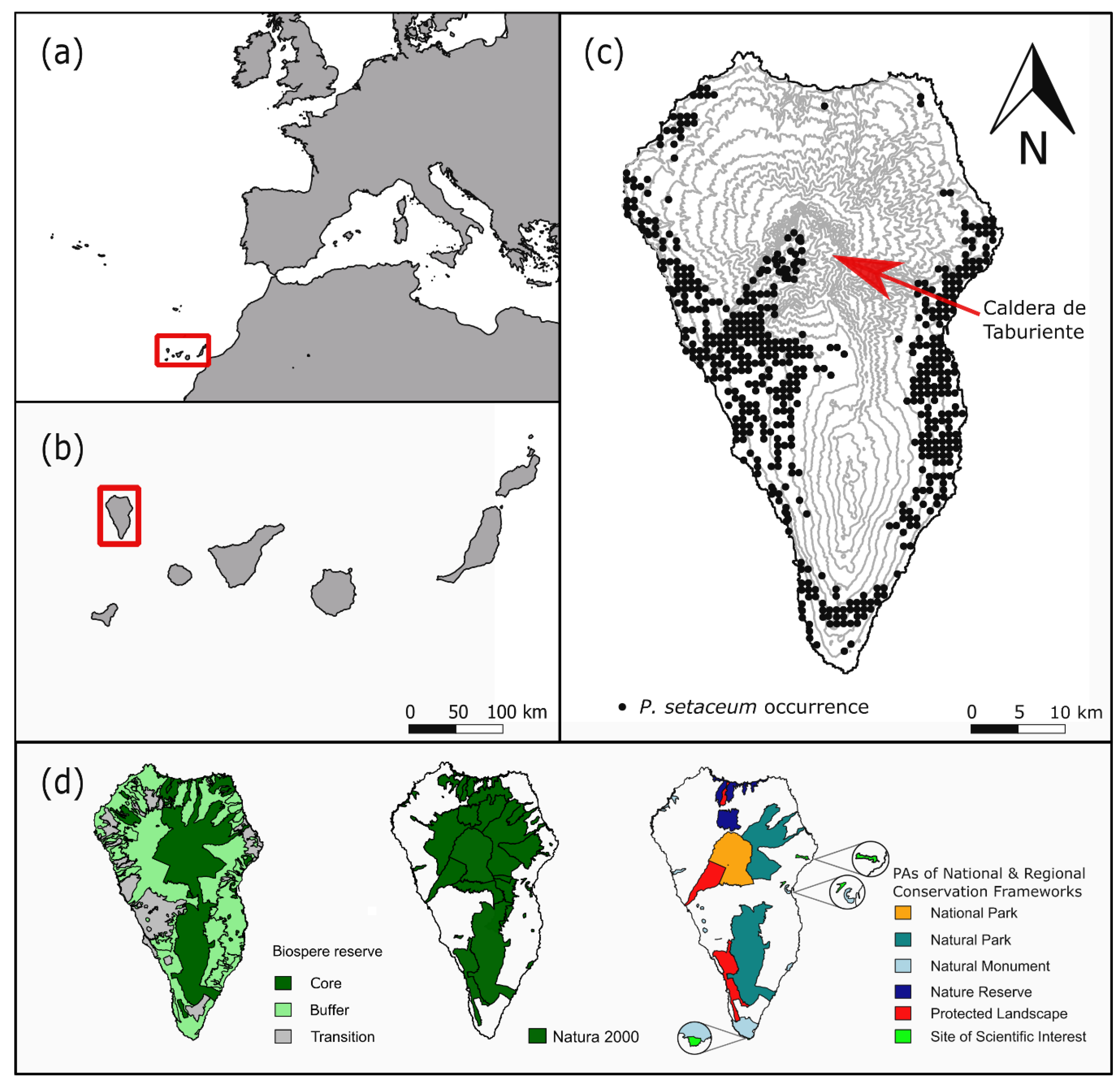
  • Occurrence data from the National Park Directorate of La Palma for P. setaceum within the National Park “La Caldera de Taburiente” from 2016, n = 55.
  • Fieldwork based occurrence data collected on a yearly basis from 2010 to 2018, n = 19.
  • Entries in the GBIF (Global Biodiversity Information Facility) database [50] for P. setaceum (only geo-referenced data; basis of record: observation, human observation) from 2012 till 2017, n = 21.
  • Occurrence data from the Atlantis database [51]. From this raster data, we created centroids within each pixel of P. setaceum occurrence with the highest precision level and a resolution of 500 × 500 m to extract occurrence points, n = 691.
We corrected for spatial correlation by spatially thinning the occurrence points in R Studio Version 3.5.3 [52] with the package spThin [53]. Based on a PCR of all occurrence points we selected a thinning parameter of 3.5 to avoid spatial clumping (nthinned = 561, Figure 1c).
To model the distribution of P. setaceum on La Palma, we selected a set of environmental variables that account for climatic, topographic, and anthropogenic aspects (Table 1, Figure A1). We used data on elevation, slope, and aspect (its components northness and eastness have been used for modeling) as topographic information. For climate, we used mean annual temperature, mean annual precipitation, and solar radiation. For model building, the anthropogenic variables ‘nearest road’ and ‘nearest settlement’ were chosen. The variable geological age was used as a proxy for bedrock nature, which is of importance for the vegetation on a young volcanic island like La Palma. We accounted for collinearity (Pearson correlation coefficient threshold of |r| = 0.7 (sensu) [54]) of the variables selected for modeling and removed mean annual temperature and nearest settlement from the analysis as these variables highly correlated with elevation. We decided to consider elevation in the modeling process and to drop the other variables because first, temperature interpolations are based on elevation linked with just a few weather stations on the island and second, elevation is more important for SDMs than the environmental variable ‘nearest settlement’.

2.2. Ensemble Modeling

An ensemble model to project the suitable habitat of P. setaceum on La Palma was created with the package biomod2 [55]. The spatial analysis was carried out at a resolution of 500 × 500 m.
Ensemble methods improve the accuracy of predictive models by synthesizing the results of single models into a single score [56]. For model building, we used presence-only data and thus used three sets of 561 randomly chosen pseudo-absences with 10 replications. An ensemble model was built based on a generalized linear model (GLM), gradient boosting machine (GBM), random forest (RF), and maximum entropy model (MaxEnt). One hundred evaluation runs were made using a 70/30 data plot approach advocated by Araújo et al. [57]. The ensemble model was built using AUC (area under the relative operating characteristic curve) as an evaluation metric. In total 3902 models with AUC > 0.7 were included in the ensemble model building. Ensemble predictions were calculated using the mean of the single models. The ensemble model prediction had a good predictive ability with AUC = 0.9 and TSS (true skill statistic) = 0.7. The AUC cutoff (threshold minimizing the absolute difference between sensitivity and specificity) of the mean was used as a threshold to transform the projection of suitable habitat for P. setaceum derived from the ensemble model into a binary presence–absence map (sensu) [58]. Further calculations were based on this binary map.

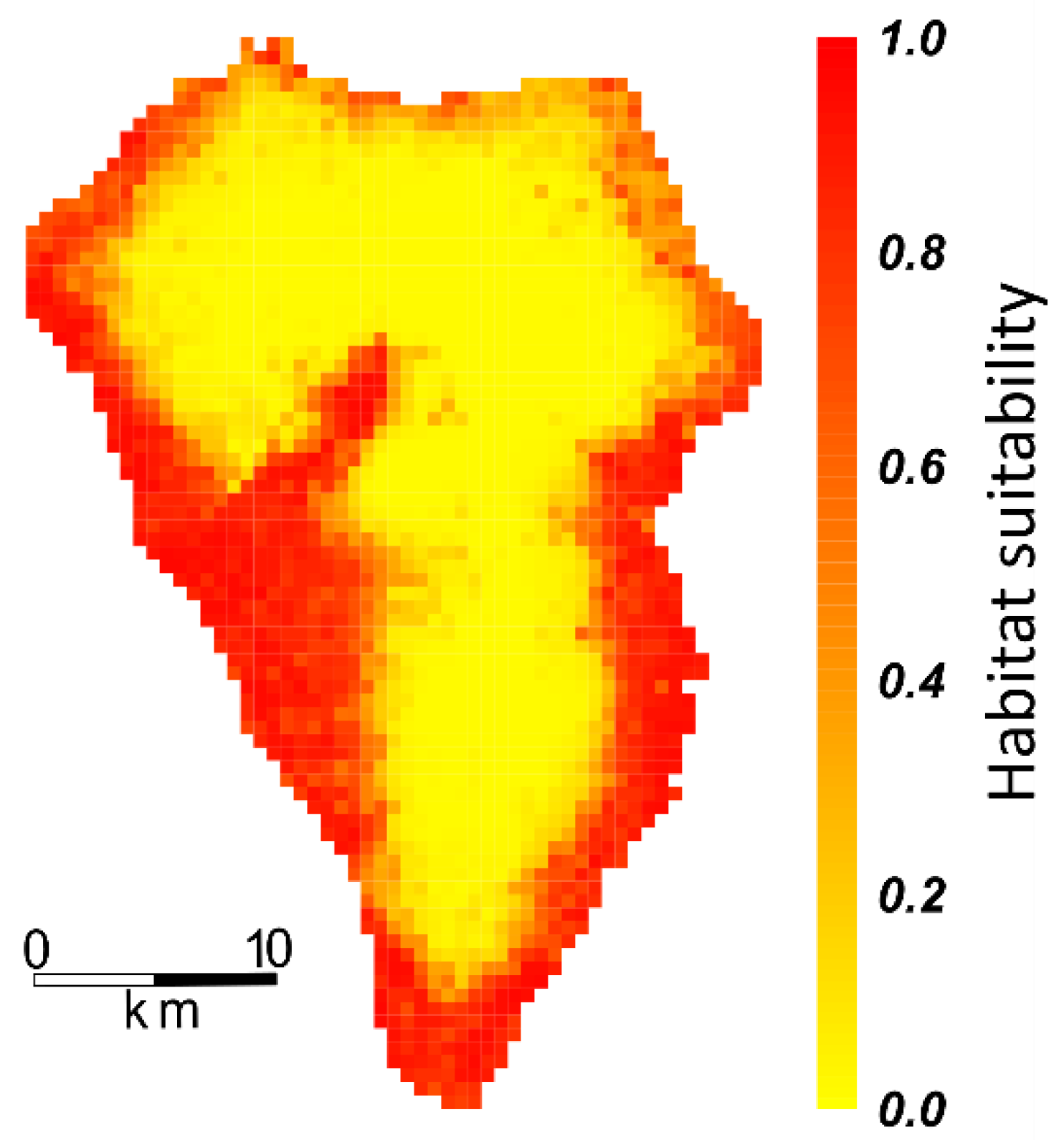
2.3. Projecting Habitat Suitability onto Ecosystems, PAs, and Endemic Plant Species Richness

Modeling results were processed for further assessment and compared with the distribution of ecosystems, species richness, and PAs on La Palma. All data were tested for normal distribution with the Shapiro–Wilk test. To compare differences in mean annual temperature and the distance to the nearest settlement of suitable and unsuitable habitat for P. setaceum, a Mann–Whitney U test was used considering a non-normal distribution of the data.
For post-modeling analysis, the environmental variables ‘mean annual temperature’ and ‘nearest settlement’ were included but had been excluded beforehand from the model building. For the environmental variables ‘mean annual temperature’, ‘annual precipitation’, ‘elevation’, ‘nearest road,’ and ‘nearest settlement,’ we extracted minimum and maximum values to depict the range these variables cover on La Palma. We calculated the percentages of these environmental gradients which we identified as suitable habitat for P. setaceum.
We derived raster maps of total plant species richness and SIE richness from Irl et al. [33]. Therein the presence/absence data of native vascular and endemic perennial plant species from 890 plots on La Palma were interpolated into richness maps. The resolution was upscaled to our model resolution of 500 × 500 m. We compared SIE richness and total plant species richness of projected suitable and unsuitable habitat for P. setaceum.
To evaluate modeling results in combination with designated areas of different protection status we considered the locations of the core, buffer, and transition zone of the biosphere reserve [59], Natura 2000 sites defined by the EU Habitat Directive [60], and nationally/ regionally designated protected areas, which include the national park, protected landscapes, natural parks, natural monuments, sites of scientific interest, and nature reserves [61]. The vector data was rasterized and scaled to 500 × 500 m. We calculated the projected suitable habitat for P. setaceum within designated areas of each protection status (cover in % and km²).

3. Results

Under current climatic conditions, 34.7% of the land surface of La Palma is identified to be suitable habitat for P. setaceum. This suitable habitat for P. setaceum is located mainly along the coasts and enters via the Barranco de las Angustias into the Caldera de Taburiente National Park on the leeward side of La Palma (Figure 3 and Figure A2).
For the single model algorithms GLM, GBM, RF, and MaxEnt, on which the ensemble model is built, we calculated the mean variable importance. In all models, elevation had the highest variable importance, followed by distance to the nearest road and mean annual precipitation (Table 2).
Projected occurrences of P. setaceum were detected more frequently in proximity to human settlements at a mean distance of 1118 m. In contrast, projected species absence pixels had a mean distance of 2168 m to human settlements (Mann–Whitney U test, psettlement < 0.0001, Figure 4a). The invasive grass species typically occurred at mean annual temperatures of 17.3 °C. In contrast, projected species absence pixels had a temperature of 14.9 °C (Mann–Whitney U test, ptemp < 0.001, Figure 4b). Mean annual temperature of suitable habitat of the invasive grass species ranged between 11.9 °C and 19.7 °C (Figure 5). Areas of projected suitable habitat for P. setaceum ranged between an elevation of 41 m and 800 m, with some exceptional occurrences at 1214 m. These high elevational projected occurrences were located without exception in the Caldera de Taburiente. For projected species presence, the precipitation varied between 212 mm/year and 901 mm/year. The distance of areas suitable for the invasive grass species to the nearest road ranged between 3 m and 2445 m. The projected suitable habitat for P. setaceum covers the entire gradient of the variables ‘nearest road’ and ‘nearest settlement’. We projected unsuitable habitat for P. setaceum on La Palma to be found in areas with low temperature, high precipitation, and high elevation.
Total species richness of SIE was significantly lower in areas of suitable habitat for P. setaceum compared to areas classified as unsuitable (Mann–Whitney U test, pSIE < 0.001, Figure 6a). However, total species richness was higher in areas suitable for P. setaceum compared to areas classified as unsuitable for the grass species (Mann–Whitney U test, prichness < 0.001, Figure 6b). Pinus canariensis forests cover large areas on La Palma and are poor in plant species diversity. We projected only a small area of this forest type to be suitable habitat for P. setaceum. Thus, when comparing total plant species richness between suitable and unsuitable habitat for P. setaceum, the P. canariensis forest might account for differences. When we excluded this ecosystem from our analysis no differences in species richness between suitable and unsuitable habitat for P. setaceum were found (Mann–Whitney U test, prichness-no-pinus = 0.391, Figure 6c). Additionally, we projected coniferous and broadleaved evergreen forests to be suitable habitat for P. setaceum only at very low percentages while scrubland, cultivated land, and bare soil were more strongly affected (Table 3).
While within the core of the La Palma Biosphere Reserve only 6.2% of the area was potential habitat for P. setaceum, the coverage reached 33.2% in the buffer zone and 67.1% in the transition zone of the biosphere reserve (Figure 7). Within Natura 2000 protected areas, a projected suitable habitat for P. setaceum of 8.6% was calculated. For the Caldera de Taburiente National Park, the natural parks, and nature reserves, low coverages of P. setaceum below 17% were detected. For other protected areas such as protected landscapes or natural monuments, the potential coverage with P. setaceum was far higher, reaching 63.0% and 93.1%, respectively.

4. Discussion

Our study is the first published assessment of the distribution and potential threat of the graminoid invader P. setaceum on La Palma. We find that about one-third of the surface of La Palma is potentially suitable for P. setaceum. The projected suitable habitat covers wide environmental gradients on the island, except for areas at very high elevations (or low temperatures) and with high amounts of precipitation. This raises major concerns for large parts of the vegetation of this island. Invasion by P. setaceum may considerably affect local ecosystems and native biodiversity. This threat demands priority control measures, especially in arid areas at low elevations and areas with high conservation value.
The importance of anthropogenic variables, e.g., the distance to the nearest road or settlement for the distribution of P. setaceum, indicates that this plant benefits from human infrastructure and activity. This is in accordance with findings from South Africa where roads strongly promote its dispersal [45,46,62,63] and relates to the dispersal of seeds by wind and car drag. Additionally, this graminoid invader is adapted to aridity typical for disturbed, sun-exposed sites in the vicinity of roads and settlements [63]. Furthermore, P. setaceum is favored by horticulturalists as an ornamental plant which adds to its success on anthropogenically influenced sites [64,65]. Recently, an exceptional occurrence of P. setaceum has been located in the northern coastal parts of La Palma (personal observation, Palomares-Martínez). However, the surroundings are anthropogenic habitats with occurrences of exotics of the genera Furcraea and Opuntia, which emphasizes the importance of disturbed areas for the dispersal of P. setaceum.
Elevation was the most important variable explaining the distribution of P. setaceum on La Palma in all model algorithms (GLM, GBM, RF, and MaxEnt) combined for the ensemble model. Our model shows a higher elevation of projected suitable habitat for P. setaceum within the Caldera de Taburiente compared to the rest of the island. As elevation is a proxy for temperature, microclimatic differences in temperature, caused by the protection from cool oceanic winds within the Caldera, can help to explain these findings. Furthermore, strong tropical storms from the southwest might be a factor to elucidate the high occurrences of P. setaceum within the Caldera de Taburiente. After storms, leaves of Persea americana and Musa sp., both agricultural plants occurring in the vicinity of the coast, have been recorded up to 2423 m a.s.l. (Acevedo Rodríguez, personal observation). Recently, occurrences of the invasive grass have been found at altitudes of 1500 m in the “Barranco Risco Liso”, located within the Caldera de Taburiente.
The elevational distribution pattern of P. setaceum hints at environmental factors playing a role in the distribution of this grass species that have not been considered in the modeling of this invasive species in this study. In the sheltered environment of the Caldera, thermal updraft might explain the differing elevational pattern of projected suitable habitat. The dispersal of P. setaceum is exclusively dependent on apomictic seeds and thus assessing the wind dispersal potential of the diaspores in combination with local wind patterns could help explaining these patterns [48,66]. Precise spatial information on predominant wind direction and topographically induced turbulence is not available for La Palma. Future provision of such maps can enhance model quality of anemochorous invasive plants.
Touristic activity within the National Park might explain the extend of the projected suitable habitat for P. setaceum within the Caldera de Taburiente. Tourism and recreational activities can influence the spread of non-native species [41]. Unpaved paths used by hikers are dispersal pathways for species such as P. setaceum [67].
For conservation efforts, the impact of invaders on natives and particularly on endemic species is of importance [68]. Remarkably, the number of endemic plant species on La Palma is significantly lower in areas identified as suitable habitat for P. setaceum compared to unsuitable areas. We can draw from this that there is little concern for this invasive grass species to outcompete or displace endemic plants on La Palma due to lower SIE richness in these areas. The latter is in accordance with general distribution patterns of endemic and invasive plant species on high-elevation islands [33,69]. While high elevations host the highest number of endemic species [69] and the aggregation of rare endemics most vulnerable to extinction aggregate there as well [59], non-native species richness peaks at elevations around 500 m [69]. Mean elevation of projected suitable habitat for P. setaceum was 543 m and matches this pattern quite precisely. P. setaceum is a C4 plant and thus well adapted to arid and semi-arid habitats [70], which explains the low coverage by suitable habitat for P. setaceum of broadleaved evergreen forest on La Palma. These broadleaved evergreen forests are mainly laurel forest communities (monteverde), located in the northeastern part of La Palma where some SIE and high numbers of Macaronesian plant endemics can be encountered [59]. The main occurrences of laurel forest coincide with high precipitation and humid localities exposed to trade winds. There are transition zones between laurel forest and the Erica-Morella-Forest (fayal-brezal) but also distinct ecotones of the pine forest driving diversity patterns linked with particular ecosystems [71].
Even though total species richness seemed to differ between projected suitable and unsuitable habitats for P. setaceum, we could show that this pattern was distorted by the P. canariensis forest on La Palma. The closed canopy of the forest prevents P. setaceum invasion and this forest type additionally contains lower species numbers compared to other ecosystems on the Canary Islands [72]. P. setaceum derives from arid areas of the Middle East and northern Africa where lush evergreen forest is scarce which can explain this pattern [42]. Additionally, P. canariensis forests historically have a high fire frequency of dominant pine species being fire-tolerant and having the ability to resprout after fire [73]. Pennisetum setaceum seeds lying on the soil surface can be killed by forest fires [47] and on the short run frequent forest fires seem to help to stop invasions of this graminoid. However, seeds buried deeper in the soil can survive these forest fires [47] and the native flora and fauna can be affected negatively by this hazard. Additionally, disturbances of natural systems (deforestation, human-caused low fire frequencies) might aid the graminoid invader in establishing within or in proximity to forest ecosystems and should be accounted for when developing conservation measures concerning P. setaceum.
A common disturbance on islands is the browsing of introduced herbivores. However, P. setaceum seems not to be negatively affected by browsing, although the graminoid mainly occurs at low elevations where introduced rabbit density is high [18]. Very likely, this results from the sharp blades of the plant using silica phytoliths as a mechanical defense against herbivory [74].
Another relevant aspect of conservation is the impact of invaders on protected areas aiming to promote and conserve endemic and native biodiversity. La Palma hosts different protected areas with different levels of protection status, as well as a UNESCO Biosphere Reserve, which covers the entire island. The specific aim of biosphere reserves is the conservation of ecosystems, species, and genetic variation [75]. We found the biosphere core area, where most rare and potentially endangered endemics are found [59], to be influenced very little by P. setaceum and, therefore, we currently do not see great concern for plant diversity within this area. The projected suitable habitat for P. setaceum in the transition area of the biosphere reserve, natural monuments, and protected landscapes reached covers of more than 60%. However, our study constitutes a snapshot in time, while biological invasions are dynamic processes that change with time and interact with their environment. A future spread of P. setaceum as a result of niche shifts via adaptation [26] and/or climate change [12] cannot be ruled out.
Evidence-based conservation allows conservationists and policymakers to focus conservation efforts and resources on problematic species that cause unwanted ecological changes or economic losses. Proceeding this way prevents misspending conservation funds on restoration measures, i.e., the eradication and control of invasive species that do not pose threats to biodiversity and human wellbeing [76]. Our identification of suitable habitat for P. setaceum on La Palma is a basis for conservationists and policy makers to prioritize conservation actions and to utilize conservation funds efficiently to maintain and protect plant species diversity on La Palma.
We suggest that immediate control measures (e.g., manual and chemical species removal efforts) should take place to prevent a further spread of P. setaceum into PAs and endanger unique endemic species. A specific focus should be put on potential vectors and invasion pathways, e.g., along roads and hiking paths. Furthermore, the control should be carried out from the border of its current distribution to avoid further spreading. Prioritized control in areas of high conservation value is recommended because monetary and labor resources are limited. Engagement of citizens, public administrations, and volunteers by means of environmental education would be useful to raise awareness and facilitate monitoring and controlling both in PAs and private land. Prohibiting the commercial use of P. setaceum lowers propagule pressure and is thus another instrument to control further spreading of the graminoid. Furthermore, we recommend implementing a monitoring system for this species in order to enable quick response times in terms of management and control of P. setaceum, if further spreading into areas of great biodiversity and ecological value is observed.
Our study on the distribution of P. setaceum as well as environmental and anthropogenic influence factors on the spread of this global invader constitutes a model case study for further islands and regions where this species has been identified as (potentially) problematic.

Author Contributions

Conceptualization, A.J.W., S.D.H.I., and C.B.; data curation, A.J.W., S.D.H.I., A.J.A.R., Á.P.-M., B.Z., F.M.M., and C.B.; formal analysis, A.J.W.; funding acquisition, C.B.; investigation, A.J.W.; methodology, A.J.W., S.D.H.I., V.V., and C.B.; visualization, A.J.W.; writing—original draft, A.J.W.; writing—review and editing, A.J.W., S.D.H.I., A.J.A.R., Á.P.-M., V.V., B.Z., F.M.M., and C.B.

Funding

This project has received funding from the European Union’s Horizon 2020 research and innovation program ECOPOTENTIAL under grant agreement No 641762. This publication was funded by the German Research Foundation (DFG) and the University of Bayreuth in the funding program Open Access Publishing.

Acknowledgments

We would like to thank Nils Tjaden and Yanchao Cheng (University of Bayreuth) for helping with the modeling process and Reinhold Stahlmann (University of Bayreuth) for his support in GIS.

Conflicts of Interest

The authors declare no conflict of interest.

Appendix A

Figure A1. Environmental variables used for building the ensemble model for P. setaceum on La Palma: geological age (a), vegetation (b), elevation (c), mean annual precipitation (d), aspect (e), slope (f), solar radiation (g), and the distance to the nearest road (h).
Diversity 11 00192 g0a1
Figure A2. Projected suitable habitat of P. setaceum on La Palma as a result of the ensemble model based on a GLM, GBM, GF, and MaxEnt model. Conversion of the modeled habitat suitability into a presence/absence-based map on 0/1 was done using the AUC (area under the relative operating characteristic curve) cutoff of the weighted mean with a threshold value of 509.5, scaled to 0.5095 in Figure 2.
Diversity 11 00192 g0a2

References

  1. Whittaker, R.J.; Fernández-Palacios, J.M. Island Biogeography: Ecology, Evolution and Conservation; Oxford University Press: Oxford, UK, 2007; pp. 295–300. [Google Scholar]
  2. Dawson, W.; Moser, D.; van Kleunen, M.; Kreft, H.; Pergl, J.; Pyšek, P.; Weigelt, P.; Winter, M.; Lenzner, P.; Blackburn, T.M.; et al. Global hotspots and correlates of alien species richness across taxonomic groups. Nat. Ecol. Evol. 2017, 1, 0186. [Google Scholar] [CrossRef]
  3. Kueffer, C.; Daehler, C.C.; Torres-Santana, C.W.; Lavergne, C.; Meyer, J.Y.; Otto, R.; Silva, L. A global comparison of invasive plant species on oceanic islands. Perspect. Plant Ecol. Syst. 2010, 12, 141–165. [Google Scholar]
  4. Moser, D.; Lenzner, B.; Weigelt, P.; Dawson, W.; Kreft, H.; Pergl, J.; Pyšek, P.; van Kleunen, M.; Winter, M.; Capinha, C.; et al. Remoteness promotes biological invasions on islands worldwide. PNAS 2018, 115, 9270–9275. [Google Scholar] [CrossRef] [Green Version]
  5. Whittaker, R.J.; Triantis, K.A.; Ladle, R.J. A general dynamic theory of oceanic island biogeography. J. Biogeogr. 2008, 35, 977–994. [Google Scholar] [CrossRef]
  6. Kier, G.; Kreft, H.; Lee, T.M.; Jetz, W.; Ibisch, P.L.; Nowicki, C.; Mutke, J.; Barthlott, W. A global assessment of endemism and species richness across island and mainland regions. PNAS 2009, 106, 9322–9327. [Google Scholar] [CrossRef] [Green Version]
  7. Convention on Biological Diversity (CBD). Global Biodiversity Outlook 3; Secretariat of the Convention on Biological Diversity: Montréal, QC, Canada, 2010. [Google Scholar]
  8. Tershy, B.R.; Shen, K.W.; Newton, K.M.; Holmes, N.D.; Croll, D.A. The importance of islands for the protection of biological and linguistic diversity. BioScience 2015, 65, 592–597. [Google Scholar] [CrossRef]
  9. Myers, N.; Mittermeier, R.A.; Mittermeier, C.G.; Da Fonseca, G.A.; Kent, J. Biodiversity hotspots for conservation priorities. Nature 2000, 403, 853–858. [Google Scholar] [CrossRef]
  10. Gray, A. The ecology of plant extinction: Rates, traits and island comparisons. Oryx 2018, 53, 424–428. [Google Scholar] [CrossRef]
  11. Whittaker, R.J.; Fernández-Palacios, J.M.; Matthews, T.J.; Borregaard, M.K.; Triantis, K.A. Island biogeography: Taking the long view of nature’s laboratories. Science 2017, 357, eaam8326. [Google Scholar] [CrossRef]
  12. Harter, D.E.V.; Irl, S.D.H.; Seo, B.; Steinbauer, M.J.; Gillespie, R.; Triantis, K.A.; Fernández-Palacios, J.M.; Beierkuhnlein, C. Impacts of global climate change on the floras of oceanic islands—Projections, implications and current knowledge. Perspect. Plant Ecol. Syst. 2015, 17, 160–183. [Google Scholar] [CrossRef]
  13. Millennium Ecosystem Assessment (Program): Ecosystems and Human Well-Being; Island Press: Washington, DC, USA, 2005.
  14. Caujapé-Castells, J.; Tye, A.; Crawford, D.; Kueffer, C. Conservation of oceanic island floras: Present and future global challenges. Perspect. Plant Ecol. Syst. 2010, 12, 107–129. [Google Scholar] [CrossRef]
  15. Irl, S.D.H.; Steinbauer, M.J.; Epperlein, L.; Harter, D.E.V.; Jentsch, A.; Pätz, S.; Wohlfart, C.; Beierkuhnlein, C. The Hitchhiker’s guide to island endemism: Biodiversity and endemic perennial plant species in roadside and surrounding vegetation. Biodivers. Conserv. 2014, 23, 2273–2287. [Google Scholar] [CrossRef]
  16. Irl, S.D.H.; Steinbauer, M.J.; Messinger, J.; Blume-Werry, G.; Palomares-Martínez, Á.; Beierkuhnlein, C.; Jentsch, A. Burned and devoured-introduced herbivores, fire, and the endemic flora of the high-elevation ecosystem on La Palma, Canary Islands. Arct. Antarct. Alp. Res. 2014, 46, 859–869. [Google Scholar] [CrossRef]
  17. Cubas, J.; Martín-Esquivel, J.L.; Nogales, M.; Irl, S.D.H.; Hernández-Hernández, R.; López-Darias, M.; Marrero-Gómez, M.; del Arco, M.J.; González-Mancebo, J.M. Contrasting effects of invasive rabbits on endemic plants driving vegetation change in a subtropical alpine insular environment. Biol. Invasions 2018, 20, 793–807. [Google Scholar] [CrossRef]
  18. Cubas, J.; Irl, S.D.H.; Villafuerte, R.; Bello-Rodríguez, V.; Rodríguez-Luengo, J.L.; del Arco, M.; Martín-Esquivel, J.L.; González-Mancebo, J.M. Endemic plant species are more palatable to introduced herbivores than non-endemics. Proc. R. Soc. B. 2019, 286, 20190136. [Google Scholar] [CrossRef]
  19. Guillera-Arroita, G.; Hauser, C.E.; McCarthy, M.A. Optimal surveillance strategy for invasive species management when surveys stop after detection. Ecol. Evol. 2014, 4, 1751–1760. [Google Scholar] [CrossRef]
  20. Araújo, M.B.; Guisan, A. Five (or so) challenges for species distribution modelling. J. Biogeogr. 2006, 33, 1677–1688. [Google Scholar] [CrossRef]
  21. Elith, J.; Leathwick, J.R.; Emery, W.P.H.; Brown, W.V. Species distribution models: Ecological explanation and prediction across space and time. Annu. Rev. Ecol. Evol. Syst. 2009, 40, 677–697. [Google Scholar] [CrossRef]
  22. Jiménez-Valverde, A.; Peterson, A.T.; Soberón, J.; Overton, L.M.; Aragón, P.; Lobo, J.M. Use of niche models in invasive species risk assessments. Biol. Invasions 2011, 13, 2785–2797. [Google Scholar] [CrossRef]
  23. Bosso, L.; De Conno, C.; Russo, D. Modelling the risk posed by the zebra mussel Dreissena polymorpha: Italy as a case study. Environ. Manag. 2017, 60, 304–313. [Google Scholar] [CrossRef]
  24. Tingley, R.; García-Díaz, P.; Rocha Arantes, C.R.; Cassey, P. Integrating transport pressure data and species distribution models to estimate invasion risk for alien stowaways. Ecography 2017, 41, 635–646. [Google Scholar] [CrossRef] [Green Version]
  25. Early, R.; Sax, D.F. Climatic niche shifts between species’ native and naturalized ranges raise concern for ecological forecasts during invasions and climate change. Glob. Ecol. Biogeogr. 2014, 23, 1356–1365. [Google Scholar] [CrossRef]
  26. Atwater, D.Z.; Ervine, C.; Barney, J.N. Climatic niche shifts are common in introduced plants. Nat. Ecol. Evol. 2017, 2, 34–43. [Google Scholar] [CrossRef]
  27. Briscoe Runquist, R.D.; Lake, T.; Tiffin, P.; Moeller, D.A. Species distribution models throughout the invasion history of palmer amaranth predict regions at risk of future invasion and reveal challenges with modeling rapidly shifting geographic ranges. Sci. Rep. 2019, 9, 2426. [Google Scholar] [CrossRef]
  28. West, A.M.; Kumar, S.; Brown, C.S.; Stohlgren, T.J.; Bromberg, J. Field validation of an invasive species MaxEnt model. Ecol. Inform. 2016, 36, 126–134. [Google Scholar] [CrossRef]
  29. Combat Invasive Alien Species—Target 5. Available online: http://ec.europa.eu/environment/nature/biodiversity/strategy/target5/index_en.htm (accessed on 18 October 2017).
  30. Datasheet Pennisetum setaceum (Fountain Grass). Available online: https://www.cabi.org/isc/datasheet/116202 (accessed on 2 October 2017).
  31. García Gallo, A.; Wildpret de la Torre, W.; CarquéÁlamo, E.; Jiménez Felipe, M.T. Ornamental flora introduced and naturalized in Tenerife. In Proceedings of the 36th IAVS Symposium, Santa Cruz de Tenerife, Canary Islands, Spain, 12 April 1993; 1997; p. 75. [Google Scholar]
  32. Fundación Canaria Reserva Mundial de la Biosfera La Palma (FRMB La Palma): Plan de Manejo de Pennisetum setaceum en la isla de La Palma. Fundación Canaria Reserva de Mundial de la Biosfera La Palma y Cabildo Insular de La Palma: Canary Islands, Spain, 2016; 57, unpublished report.
  33. Irl, S.D.H.; Harter, D.E.V.; Steinbauer, M.J.; Puyol, D.G.; Fernández-Palacios, J.M.; Jentsch, A.; Beierkuhnlein, C. Climate vs. topography—Spatial patterns of plant species diversity and endemism on a high-elevation island. J. Ecol. 2015, 103, 1621–1633. [Google Scholar] [CrossRef]
  34. Garzón-Machado, V.; Otto, R.; del Arco Aguilar, M.J. Bioclimatic and vegetation mapping of a topographically complex oceanic island applying different interpolation techniques. Int. J. Biometeorol. 2014, 58, 887–899. [Google Scholar] [CrossRef]
  35. del Arco Aguilar, M.J.; González-González, R.; Garzón-Machado, V.; Pizarro-Hernández, B. Actual and potential natural vegetation on the Canary Islands and its conservation status. Biodivers. Conserv. 2010, 11, 3089–3140. [Google Scholar] [CrossRef]
  36. Muer, R.; Sauerbier, H.; Cabrera Calixto, F. Die Farn-und Blütenpflanzen der Kanarischen Inseln; Margraf Publishers: Weikersheim, Germany, 2016; p. 20. [Google Scholar]
  37. Fernández-Palacios, J.M.; Arévalo, J.R.; Balguerías, E.; Barone, R.; de Nascimento, L.; Delgado, J.D.; Bento Elias, R.; Fernández-Lugo, S.; Méndez, J.; Menezes de Sequeira, M.; et al. La Laurisilva. Canarias, Madeira y Azores; Macaronesia Editorial: Santa Cruz de Tenerife, Spain, 2017. [Google Scholar]
  38. Parson, J. Human influences on the pine and laurel forests of the Canary Islands. Geogr. Rev. 1981, 71, 253–271. [Google Scholar] [CrossRef]
  39. Santos, A. Flora vascular nativa. In Naturaleza de las Islas Canarias. Ecología y Conservación; Fernández-Palacios, J.M., Martín Esquivel, J.L., Eds.; Publicaciones Turquesa SL: Santa Cruz de Tenerife, Spain, 2001; pp. 185–192. [Google Scholar]
  40. Evolución del número de turistas que visitaron la isla de La Palma (Canarias) de 2013 a 2018. Available online: https://es.statista.com/estadisticas/524031/numero-de-turistas-que-visitaron-la-isla-de-la-palma-canarias/ (accessed on 8 September 2019).
  41. Andersen, K.M.; Naylor, B.J.; Endress, B.A.; Parks, C.G. Contrasting distribution patterns of invasive and naturalized non-native species along environmental gradients in a semi-arid montane ecosystem. Appl. Veg. Sci. 2015, 18, 683–693. [Google Scholar] [CrossRef]
  42. Corona, P.; Badalamenti, E.; Pasta, S.; La Mantia, T. Carbon storage of Mediterranean grasslands. Anales del Jardín Botánico de Madrid 2016, 73, e029. [Google Scholar] [CrossRef]
  43. Santos, A. Vegetación y Flora de La Palma; Editorial Interinsular Canaria S. A.: Canary Islands, Spain, 1983; p. 348. [Google Scholar]
  44. Pérez de Paz, P.L.; García Gallo, A.; Heene, A. Control y Erradicación del “Rabo-gato” [Pennisetum setaceum] en la isla de La Palma; Cabildo Insular de La Palma: Canary Islands, Spain, 1999; p. 124. [Google Scholar]
  45. Emery, W.P.H.; Brown, W.V. Apomixis in the Gramineae: Tribe Andropogoneae: Heteropogon contortus. Madroño 1958, 14, 238–246. [Google Scholar]
  46. Simpson, C.E.; Bashaw, E.C. Cytology and reproductive characteristics in Pennisetum setaceum. Am. J. Bot. 1969, 56, 31–36. [Google Scholar] [CrossRef]
  47. Adkins, E.; Cordell, S.; Drake, D.R. Role of fire in the germination ecology of fountain grass (Pennisetum setaceum), an invasive African bunchgrass in Hawai’i. Pac. Sci. 2011, 65, 17–25. [Google Scholar] [CrossRef]
  48. Poulin, J.; Weller, S.G.; Sakai, A.K. Genetic diversity does not affect the invasiveness of fountain grass (Pennisetum setaceum) in Arizona, California and Hawaii. Divers. Distrib. 2005, 11, 241–247. [Google Scholar] [CrossRef]
  49. Fountain Grass Control in Hawaii Volcanoes National Park: Management Considerations and Strategies. Available online: https://pdfs.semanticscholar.org/3a9a/2367472594af878c5447e442040a7c998b5c.pdf (accessed on 3 October 2017).
  50. GBIF Secretariat. Pennisetum Setaceum (Forssk.) Chiov. Available online: https://www.gbif.org/species/2706134 (accessed on 26 September 2017).
  51. Atlantis 3.3.0. Banco de Datos de Biodiversidad de Canarias. Available online: http://www.biodiversidadcanarias.es/atlantis/ (accessed on 22 October 2018).
  52. R Core Team. R: A Language and Environment for Statistical Computing; R Foundation for Statistical Computing: Vienna, Austria, 2019; Available online: URL https://www.R-project.org/ (accessed on 13 September 2019).
  53. Aiello-Lammens, M.E.; Boria, R.A.; Radosavljevic, A.; Vilela, B.; Anderson, R.P. spThin: Functions for Spatial Thinning of Species Occurrence Records for Use in Ecological Models. R packageversion 0.1.0. 2014. Available online: https://CRAN.R-project.org/package=spThin (accessed on 13 September 2019).
  54. Dormann, C.F.; Elith, J.; Bacher, S.; Buchmann, C.; Carl, G.; Carré, G.; García Marquéz, J.R.; Gruber, B.; Lafourcade, B.; Leitão, P.J.; et al. Collinearity: A review of methods to deal with it and a simulation study evaluating their performance. Ecography 2013, 36, 27–46. [Google Scholar] [CrossRef]
  55. Thuiller, W.; Georges, D.; Engler, R.; Breiner, F. Biomod2: Ensemble Platform for Species Distribution Modeling. R Packageversion 3.3-7. 2016. Available online: https://CRAN.R-project.org/package=biomod2 (accessed on 13 September 2019).
  56. Seni, G.; Elder, J.F. Ensemble Methods in Data Mining: Improving Accuracy Through Combining Predictions; Morgan & Claypool Publishers: San Rafael, CA, USA, 2010; pp. 2–3. [Google Scholar]
  57. Araújo, M.B.; Pearson, R.G.; Thuiller, W.; Erhard, M. Validation of species-climate impact models under climate change. Glob. Chang. Biol. 2005, 11, 1504–1513. [Google Scholar] [CrossRef] [Green Version]
  58. Liu, C.; Berry, P.M.; Dawson, T.P.; Pearson, G. Selecting thresholds of occurrence in the prediction of species distributions. Ecography 2005, 28, 385–393. [Google Scholar] [CrossRef]
  59. Irl, S.D.H.; Schweiger, A.H.; Medina, F.M.; Fernández-Palacios, J.M.; Harter, D.E.V.; Jentsch, A.; Provenzale, A.; Steinbauer, M.J.; Beierkuhnlein, C. An island view of endemic rarity—Environmental drivers and consequences for nature conservation. Divers. Distrib. 2017, 23, 1132–1142. [Google Scholar] [CrossRef]
  60. Vera-Galván, M.A.; Samarín-Bello, C.; Delgado-Castro, G.; Viera-Ruíz, G. Natura 2000 en Macaronesia: Azores, Madeira; Gobierno de Canarias: Canary Islands, Spain, 2010; p. 576. [Google Scholar]
  61. Martín-Esquivel, J.L.; García-Court, H.; Redondo-Rojas, C.E.; García-Fernández, I.; Carralero-Jaime, I. La Red Canaria de Espacios Naturales Protegidos; Gobierno de Canarias: Canary Islands, Spain, 1995; p. 452. [Google Scholar]
  62. Rahlao, S.J.; Milton, S.J.; Esler, K.L.; Barnard, P. The distribution of invasive Pennisetum setaceum along roadsides in western South Africa: The role of corridor interchanges. Restor. Ecol. 2010, 20, 475–482. [Google Scholar] [CrossRef]
  63. Rahlao, S.J.; Milton, S.J.; Esler, K.L.; Barnard, P. Performance of invasive alien fountain grass (Pennisetum setaceum) along a climatic gradient through three South African biomes. S. Afr. J. Bot. 2014, 91, 43–48. [Google Scholar] [CrossRef]
  64. Milton, S.J.; Hoffmann, J.H.; Bowie, R.C.K.; D’Amico, J.; Griffiths, M.; Joubert, D.; Loewenthal, D.; Moinde, N.N.; Seymour, C.; Toral-Granda, M.V.; et al. Invasive fountain grass on the Cape Peninsula. S. Afr. J. Sci. 1998, 94, 57–58. [Google Scholar]
  65. García-Gallo, A.; Wildpret de la Torre, W.; Rodríguez Delgado, O.; Pérez de Paz, P.L.; León Arencibia, M.C.; Suárez Rodriguez, C.; Reyes-Betancort, J.A. El xenófito Pennisetum setaceum en las islas Canarias (Magnoliophyta, Poaceae). Vieraea 1999, 27, 133–158. [Google Scholar]
  66. Tackenberg, O.; Poschlod, P.; Bonn, S. Assessment of wind dispersal potential in plant species. Ecol. Monogr. 2003, 73, 191–205. [Google Scholar] [CrossRef]
  67. Barros, A.; Pickering, C.M. Non-native plant invasion in relation to tourism use of Aconcagua Park, Argentina, the highest protected area in the Southern Hemisphere. Mt. Res. Dev. 2014, 34, 13–27. [Google Scholar] [CrossRef]
  68. Simberloff, D. Invasive Species. In Conservation Biology for All; Sodhi, N.S., Ehrlich, P.R., Eds.; Oxford University Press: Oxford, UK, 2010; pp. 131–152. [Google Scholar]
  69. Steinbauer, M.J.; Irl, S.D.H.; González-Mancebo, J.M.; Breiner, F.T.; Hernández-Hernández, R.; Hopfenmüller, S.; Kidane, Y.; Jentsch, A.; Beierkuhnlein, C. Plant invasion and speciation along elevational gradients on the oceanic island La Palma, Canary Islands. Ecol. Evol. 2017, 7, 771–779. [Google Scholar] [CrossRef] [PubMed]
  70. González-Rodríguez, A.M.; Baruch, Z.; Palomo, D.; Cruz-Trujillo, G.; Jiménez, M.S.; Morales, D. Ecophysiology of the invader Pennisetum setaceum and three native grasses in the Canary Islands. Acta Oecol. 2010, 36, 248–254. [Google Scholar] [CrossRef]
  71. Hoffmann, S.; Schmitt, T.; Chiarucci, A.; Irl, S.; Rocchini, D.; Vetaas, O.R.; Tanase, M.A.; Mermoz, S.; Bouvet, A.; Beierkuhnlein, C. Remote sensing of beta diversity: Evidence from plant communities in a semi-natural system. Appl. Veg. Sci. 2019, 22, 13–26. [Google Scholar] [CrossRef]
  72. Garzón-Machado, V.; González-Mancebo, J.M.; Palomares-Martínez, A.; Acevedo-Rodríguez, A.; Fernández-Palacios, J.M.; del-Arco-Aguilar, M.; Pérez-de-Paz, P.L. Strong negative effect of alien herbivores on endemic legumes of the Canary pine forest. Biol. Conserv. 2010, 143, 2685–2694. [Google Scholar] [CrossRef]
  73. Molina-Terrén, D.M.; Fry, D.L.; Grillo, F.F.; Cardil, A.; Stephens, S.L. Fire history and management of Pinus canariensis forests on the western Canary Islands Archipelago, Spain. For. Ecol. Manag. 2016, 382, 184–192. [Google Scholar] [CrossRef]
  74. Hartley, S.E.; Fitt, R.N.; McLarnon, E.L.; Wade, R.N. Defending the leaf surface: Intra-and inter-specific differences in silicon deposition in grasses in response to damage and silicon supply. Front. Plant Sci. 2015, 6, 35. [Google Scholar] [CrossRef] [PubMed]
  75. UNESCO Biosphere Reserves—Learning Sites for Sustainable Development. Available online: http://www.unesco.org/new/en/natural-sciences/environment/ecological-sciences/biosphere-reserves/ (accessed on 14 January 2018).
  76. Sutherland, W.J.; Pullin, A.S.; Dolman, P.M.; Knight, T.M. The need for evidence-based conservation. Trends Ecol. Evol. 2004, 19, 305–308. [Google Scholar] [CrossRef] [PubMed]
Figure 1. Location of the Canary Islands (a) and the position of La Palma within the archipelago (b). Distribution of Pennisetum setaceum occurrence points after correction for autocorrelation (nthinned = 561) that was used for species distribution modeling (c). Biosphere reserve (left, d), Natura2000 sites (middle, d), and nationally and regionally designated protected areas (right, d).
Diversity 11 00192 g001
Figure 2. The Crimson fountain grass Pennisetum setaceum as an invader on La Palma.
Diversity 11 00192 g002
Figure 3. Projected suitable habitat conditions of P. setaceum on La Palma based on the ensemble model of generalized linear model (GLM), gradient boosting machine (GBM), random forest (RF), and maximum entropy model (MaxEnt). Habitat suitability ranges from 1 (high probability of occurrence, red) to 0 (low probability of occurrence, yellow).
Diversity 11 00192 g003
Figure 4. (a) Pixels that were modeled as suitable habitat for P. setaceum show smaller distances to the nearest settlement compared to pixels without P. setaceum. (b) Average mean annual temperatures of pixels with P. setaceum presence are considerably higher compared to pixels where the species is absent. Highly significant results are indicated by three asterisks.
Diversity 11 00192 g004
Figure 5. Total environmental gradients of mean annual temperature, annual precipitation, elevation, nearest road, and nearest settlement on La Palma (black bar). Red bars show the range of the environmental gradients projected to represent a suitable habitat for P. setaceum on La Palma. Note that the gradients elevation, nearest settlement, and nearest road do not start at zero due to calculations made on the bases of mean values for pixels the size of 500 × 500 m.
Diversity 11 00192 g005
Figure 6. (a) Single island endemic plant species richness in projected suitable and unsuitable habitat for P. setaceum. (b) Total species richness in areas suitable and unsuitable for P. setaceum. (c) Species richness of unsuitable compared to suitable habitat excluding the Pinus canariensis forest. Highly significant results are indicated by three asterisks.
Diversity 11 00192 g006
Figure 7. Projected suitable habitat for P. setaceum in protected areas on La Palma in coverage percent and area in km².
Diversity 11 00192 g007
Table 1. Environmental variables used for species distribution modeling of suitable habitat of P. setaceum on La Palma, including also the calculations of variables and the source.
CategoryVariableCalculation of VariablesSources
TopographyElevationRasterized at a resolution of 0.5 × 0.5 km deriving from a digital elevation model (DEM) of 2 × 2 m.Original Data: Cabildo Insular de La Palma, [33]
SlopeCalculations were based on a DEM of 2 × 2 m. Resolution was rescaled to 0.5 × 0.5 km.Original Data: Cabildo Insular de La Palma, Calculations [33]
Aspect (northness, eastness)Calculations were based on a DEM of 2 × 2 m. Resolution was rescaled to 0.5 × 0.5 km. Northness was calculated as cos(aspect) and eastness as sin(aspect).Original Data: Cabildo Insular de La Palma, Calculations [33]
Parent materialGeological ageResolution was rescaled to 0.5 × 0.5 km.Cabildo Insular de La Palma, [33]
Climate dataMean annual precipitationInterpolation (Linear regression kriging), using data collected from meteorological stations for the Canary Islands (n = 214). Time span from 1969 to 1998. Resolution was rescaled to 0.5 × 0.5 km.Original Data: Cabildo Insular de La Palma, Calculations [33]
Solar radiationCalculation from DEM 100 × 100m using a standard diffuse atmosphere and based on latitude, elevation, slope, and aspect. Resolution was rescaled to 0.5 × 0.5 km.Original Data: Cabildo Insular de La Palma, Calculations [33]
InfrastructureNearest roadResolution was rescaled to 0.5 × 0.5 km.[33]
Land coverVegetation types (coniferous forest, broadleaved evergreen forest, scrubland, cultivated land, barren land)Rasterized at a resolution of 0.5 × 0.5 kmOriginal Data: Cabildo Insular de La Palma [33]
Table 2. Variable importance for the single model algorithms (GLM, MaxEnt, RF, and GBM) of the ensemble modeling approach. The three most important variables for each model are written in bold. Variables are ranked from highest (1.) to lowest (9.) importance.
Variable GLMMaxEntRFGBM
1. Elevation0.9630.5730.4800.676
2. Precipitation0.0430.2450.1550.162
3. Nearest road0.1800.2250.0730.071
4. Solar radiation0.1530.1040.0800.061
5. Slope0.0120.1370.0340.017
6. Vegetation0.0220.0510.0270.006
7. Northness0.0000.0700.0210.008
8. Eastness0.0000.0900.0130.002
9. Geological age0.0000.0630.0230.007
Table 3. Projected suitable habitat for P. setaceum within the coniferous forest, broadleaved evergreen forest, shrubland, cultivated land, and bare soil of La Palma as total cover of ecosystem, total suitable habitat for P. setaceum, and percentage cover of suitable habitat for P. setaceum.
EcosystemTotal Cover in km²Suitable Habitat for P. setaceum
Coniferous forest224 km²20 km² (9%)
Broadleaved evergreen forest99 km²1 km² (1%)
Scrubland78 km²51 km² (65%)
Cultivated land214 km²130 km² (61%)
Bare soil34 km²22 km² (65%)

