Recent Contributions of Some Fields of the Electronics in Development of Forest Operations Technologies

 ,
,  ,
,  ,
,
Abstract
:1. Introduction
2. Materials and Methods
Literature Search
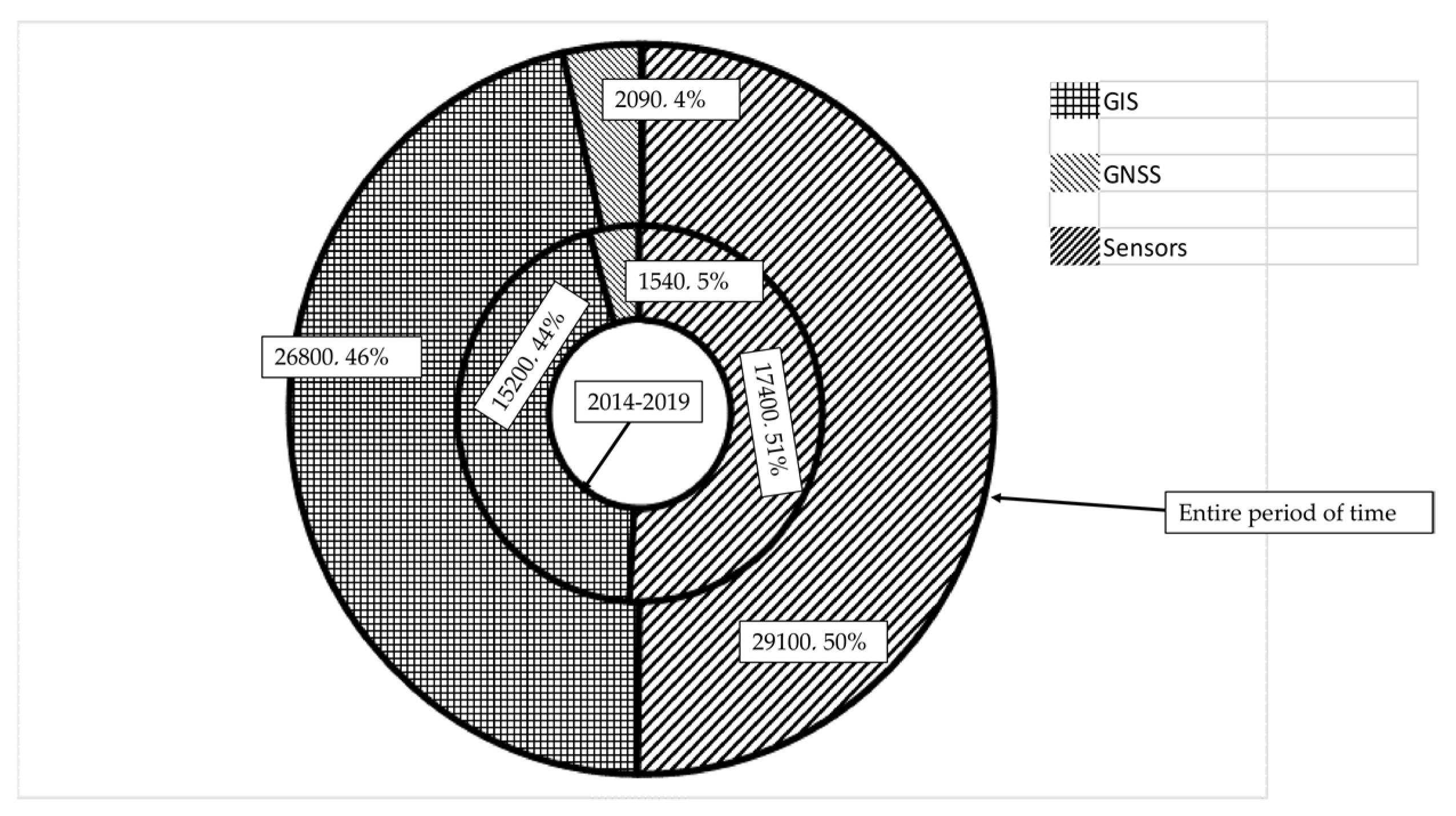
3. Results
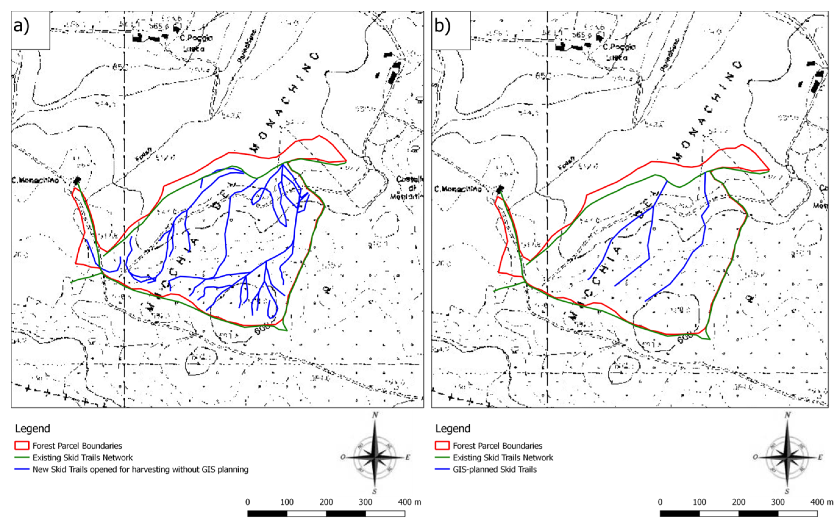
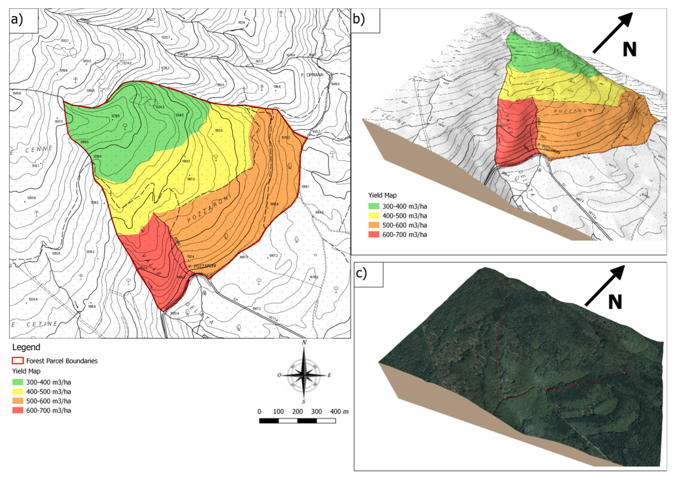
3.1. GIS Applications
3.2. GNSS Instruments
3.3. Machine Sensors
An Overview of Forest Machine Automation Purpose
3.4. A Little Focus on Smartphones Applications
4. Conclusions
Author Contributions
Funding
Acknowledgments
Conflicts of Interest
Acronyms and Forestry Technicality Used in the Text
| ATV | All-terrain vehicle |
| CTL (cut to length) | Harvesting systems in which trees are delimbed and bucked into sorted piles at the stump prior to subsequent transport to the landing by skidding or forwarding |
| DGPS-DGNSS | Differential positioning system (DGPS-DGNSS) is a method of correction requiring at least two GPS-GNSS receivers; one placed at the base station whose geographic coordinates are precisely known and another placed in the field. Correction values from the base station can then be used to improve the positioning of the second receiver. |
| DSS (decision support system) | An information system that supports business or organizational decision-making activities and helps people to make decisions about problems. |
| GIS (geographic information system) | A system designed to capture, store, manipulate, analyze, manage, and present spatial or geographic data. GIS applications are tools that allow users to create interactive queries (user-created searches), analyze spatial information, edit data in maps, and present the results of all these operations. |
| GNSS (global navigation satellite system) | A satellite navigation system with global coverage, integrating both United States’ global positioning system (GPS) and Russia’s GLONASS. |
| GNSS-RF | System that integrates both GNSS and Radio Frequency. |
| ICT (information and communication technology) | An extensional term for information technology (IT) that stresses the role of unified communications and the integration of telecommunications (telephone lines and wireless signals) and computers, as well as necessary enterprise software, middleware, storage, and audiovisual systems, that enable users to access, store, transmit, and manipulate information. |
| IMU (inertial measurement unit) | An electronic device that measures and reports a body’s specific force, angular rate, and sometimes the orientation of the body, using a combination of accelerometers, gyroscopes, and sometimes magnetometers. IMUs are typically used to maneuver aircraft (an attitude and heading reference system), including unmanned aerial vehicles (UAVs). Recent developments allowed production of IMU-enabled GPS devices. An IMU allows a GPS receiver to work when GPS-signals are unavailable, such as in tunnels, inside buildings, or when electronic interference is present. |
| LiDAR (light imaging, detection, and ranging) | A surveying method that measures distance to a target by illuminating the target with laser light and measuring the reflected light with a sensor. Differences in laser return times and wavelengths can then be used to make digital 3-D representations of the target. |
| LOA | Level of automation. |
| MCDA (multi criteria decision analysis) | A sub-discipline of operations research that explicitly evaluates multiple conflicting criteria in decision making. |
| OBC | On-board computers. |
| RFID (radio frequency identification) | System using electromagnetic fields to automatically identify, and track tags attached to objects. |
| RDN DGPS | Radio beacon differential global positioning system is a supplementary correction signal used by GPS receivers to increase the accuracy of GPS based positioning. |
| RTK (real time kinematic) | Real-time kinematic (RTK) positioning is a satellite navigation technique used to enhance the precision of position data derived from satellite-based positioning systems. It uses measurements of the phase of signal’s carrier wave in addition to the information content of the signal and relies on a single reference station or interpolated virtual station to provide real-time corrections, observing up to centimeter-level accuracy. With reference to GPS in particular, the system is commonly referred to a carrier-phase enhancement, or CPGPS. |
| SLAM (simultaneous localization and mapping) | A process for which a robot moves in unknown environment, creates a map of this one, and is able to locate itself within this map. |
| SKID ROAD | a properly road, with all related infrastructures like drainage ditches, used by skidders or forestry fitted farm tractors for bunching and extraction of wood material. |
| SKID TRAIL | A trail with no infrastructures like drainage ditches, and so not a properly road, used by skidders or forestry fitted farm tractors for bunching and extraction of wood material. |
| SSF (small-scale forestry) | Forestry linked to small or family enterprises characterized by low-medium level of mechanization and poor amount of harvested timber volume. |
| StanForD (standard for forest data and communication) | Standard for communication between computers in forest machines. |
| STRIP ROAD | The same as skid trails but with particular reference to CTL machinery like forwarders and harvesters. |
| SVM (support vector machine) model | In machine learning, support-vector machines are supervised learning models with associated learning algorithms that analyze data used for classification and regression analysis. |
| UAV | Unmanned aerial vehicle. |
| VHF (very high frequency) | The range of radio frequency electromagnetic waves (radio waves) from 30 to 300 megahertz (MHz), with corresponding wavelengths of ten meters to one meter. |
References
- Corona, P.; Chianucci, F.; Quatrini, V.; Civitarese, V.; Clementel, F.; Costa, C.; Floris, A.; Menesatti, P.; Puletti, N.; Sperandio, G.; et al. Precision forestry: Riferimenti concettuali, strumenti e prospettive di diffusione in Italia. Forest 2017, 14, 1–21. [Google Scholar] [CrossRef]
- Ziesak, M. Precision Forestry—An overview on the current status of Precision Forestry. A literature review. In Proceedings of the Precision Forestry in Plantations, Semi-Natural and Natural Forests, IUFRO Precision Forestry Conference Technical University, Munich, Germany, 5–10 March 2006. [Google Scholar]
- Kaartinen, H.; Hyyppä, J.; Vastaranta, M.; Kukko, A.; Jaakkola, A.; Yu, X.; Pyörälä, J.; Liang, X.; Liu, J.; Wang, Y.; et al. Accuracy of Kinematic Positioning Using Global Satellite Navigation Systems under Forest Canopies. Forests 2015, 6, 3218–3236. [Google Scholar] [CrossRef]
- Cambi, M.; Certini, G.; Fabiano, F.; Foderi, C.; Laschi, A.; Picchio, R. Impact of wheeled and tracked tractors on soil physical properties in a mixed conifer stand. iForest 2016, 9, 89–94. [Google Scholar] [CrossRef]
- Picchio, R.; Magagnotti, N.; Sirna, A.; Spinelli, R. Improved winching technique to reduce logging damage. Ecol. Eng. 2012, 47, 83–86. [Google Scholar] [CrossRef]
- Picchio, R.; Spina, R.; Calienno, L.; Venanzi, R.; Lo Monaco, A. Forest operations for implementing silvicultural treatments for multiple purposes. Ital. J. Agron. 2016, 11, 156–161. [Google Scholar]
- Marchi, E.; Chung, W.; Visser, R.; Abbas, D.; Nordfjell, T.; Mederski, P.S.; McEwan, A.; Laschi, A. Sustainable Forest Operations (SFO): A new paradigm in a changing world and climate. Sci. Total Environ. 2018, 634, 1385–1397. [Google Scholar] [CrossRef]
- Grigolato, S.; Mologni, O.; Cavalli, R. GIS Applications in Forest Operations and Road Network Planning: An Overview over the Last Two Decades. Croat. J. For. Eng. 2017, 38, 175–186. [Google Scholar]
- Longley, P.; Goodchild, M.F.; Maguire, D.J.; Rhind, D.W. Geographic Information Science and System, 4th ed.; John Wiley Sons, Ltd.: New York, NY, USA, 2011; 496p. [Google Scholar]
- Bone, C.; Dragićević, S. Evaluating spatio-temporal complexities of forest management. Environ. Model. Assess. 2009, 14, 481–496. [Google Scholar] [CrossRef]
- Picchio, R.; Latterini, F.; Medersky, P.S.; Venanzi, R.; Karaszewski, Z.; Bembenek, M.; Croce, M. Comparing Accuracy of Three Methods Based on the GIS Environment for Determining Winching Areas. Electronics 2019, 8, 53. [Google Scholar] [CrossRef]
- Çalişkan, E.; Bediroglu, Ş.; Yildirim, V. Determination forest road routes via GIS-based spatial multi-criterion decision methods. Appl. Ecol. Environ. Res. 2019, 17, 759–779. [Google Scholar] [CrossRef]
- Talebi, M.; Majnounian, B.; Makhdoum, M.; Abdi, E.; Omid, M.; Marchi, E.; Laschi, A. A GIS-MCDM-based road network planning for tourism development and management in Arasbaran forest, Iran. Environ. Monit. Assess. 2019, 191, 647. [Google Scholar] [CrossRef] [PubMed]
- Enache, A.; Pentek, T.; Ciobanu, V.D.; Stampfer, K. GIS based methods for computing the mean extraction distance and its correction factors in Romanian mountain forests. Šumar. List 2015, 139, 35–46. [Google Scholar]
- Đuka, A.; Grigolato, S.; Papa, I.; Pentek, T.; Poršinsky, T. Assessment of timber extraction distance and skid road network in steep karst terrain. iForest 2016, 10, 886–894. [Google Scholar] [CrossRef]
- Enache, A.; Ciobanu, V.D.; Kühmaier, M.; Stampfer, K. An Integrative Decision Support Tool for Assessing Forest Road Options in a Mountainous Region in Romania. Croat. J. For. Eng. 2013, 34, 43–60. [Google Scholar]
- Yue, C.-D.; Yang, G.G.-L. Decision support system for exploiting local renewable energy sources: A case study of the chigu area of southwestern Taiwan. Energy Policy 2007, 35, 383–394. [Google Scholar] [CrossRef]
- Buchholz, T.; Rametsteiner, E.; Volk, T.A.; Luzadis, V.A. Multi criteria analysis for bioenergy systems assessments. Energy Policy 2009, 37, 484–495. [Google Scholar] [CrossRef]
- Van Dael, M.; Van Passel, S.; Pelkmans, L.; Guisson, R.; Swinnen, G.; Schreurs, E. Determining potential locations for biomass valorization using a macro screening approach. Biomass Bioenergy 2012, 45, 175–186. [Google Scholar] [CrossRef]
- Perpiña, C.; Martínez-Llario, J.C.; Pérez-Navarro, Á. Multicriteria assessment in GIS environments for siting biomass plants. Land Use Policy 2013, 31, 326–335. [Google Scholar] [CrossRef]
- Mourmouris, J.; Potolias, C. A multi-criteria methodology for energy planning and developing renewable energy sources at a regional level: A case study Thassos, Greece. Energy Policy 2013, 52, 522–530. [Google Scholar] [CrossRef]
- Boggia, A.; Cortina, C. Measuring sustainable development using a multi-criteria model: A. case study. J. Environ. Manag. 2010, 91, 2301–2306. [Google Scholar] [CrossRef]
- Contreras, M.A.; Parrot, D.L.; Chung, W. Designing Skid-Trail Networks to Reduce Skidding Cost and Soil Disturbance for Ground-Based Timber Harvesting Operations. For. Sci. 2016, 62, 48–58. [Google Scholar] [CrossRef]
- Gumus, S.; Turk, Y. A New Skid Trail Pattern Design for Farm Tractors Using Linear Programing and Geographical Information Systems. Forests 2016, 7, 306. [Google Scholar] [CrossRef]
- Parsakhoo, A.; Mostafa, M.; Shataee, S.; Lotfalian, M. Decision support system to find a skid trail network for extracting marked trees. J. For. Sci. 2017, 63, 62–69. [Google Scholar]
- Synek, M.; Klimanek, M. Proposal of using GIS for multi-criteria evaluation of environmentally friendly use of skidding technologies in forestry. J. For. Sci. 2014, 60, 51–60. [Google Scholar] [CrossRef]
- Laschi, A.; Neri, F.; Brachetti Montorselli, N.; Marchi, E. A Methodological Approach Exploiting Modern Techniques for Forest Road Network Planning. Croat. J. For. Eng. 2016, 37, 319–331. [Google Scholar]
- Picchio, R.; Pignatti, G.; Marchi, E.; Latterini, F.; Benanchi, M.; Foderi, C.; Venanzi, R.; Verani, S. The Application of Two Approaches Using GIS Technology Implementation in Forest Road Network Planning in an Italian Mountain Setting. Forests 2018, 9, 277. [Google Scholar] [CrossRef]
- Caliskan, E.; Karahalil, U. Evaluation of forest road network and determining timber extraction system using GIS: A case study in Anbardag planning unit. Šumar. List 2017, 141, 163–171. [Google Scholar] [CrossRef]
- Vopĕnka, P.; Kašpar, J.; Marušák, R. GIS tool for optimization of forest harvest-scheduling. Comput. Electron. Agric. 2015, 113, 254–259. [Google Scholar] [CrossRef]
- Mauro, F.; Valbuena, R.; Manzanera, J.A.; Garcìa-Abril, A. Influence of Global Navigation Satellite System errors in positioning inventory plots for tree height distribution studies. Can. J. For. Res. 2010, 41, 11–23. [Google Scholar] [CrossRef]
- Gerlach, F.L. GPS in forestry. Compiler 1991, 9, 3–6. [Google Scholar]
- Gallo, R.; Grigolato, S.; Cavalli, R.; Mazzetto, F. GNSS-based operational monitoring devices for forest logging operation chains. J. Agric. Eng. 2013, 44, 140–144. [Google Scholar] [CrossRef]
- Hejazian, M.; Hosseini, S.; Lotfalian, M.; Ahmadikoolaei, P. Possibility of global positioning system (GPS) application for time studies inforest machinery. Eur. J. Exp. Biol. 2013, 3, 93–98. [Google Scholar]
- Macrì, G.; Russo, D.; Zimbalatti, G.; Proto, A.R. Measuring the mobility parameters of tree-length forwarding systems using GPS technology in the Southern Italy forestry. Agron. Res. 2016, 14, 836–845. [Google Scholar]
- Apafaian, A.I.; Proto, A.R.; Borz, S.A. Performance of a mid-sized harvester-forwarder system in integrated harvesting of sawmill, pulpwood and firewood. Ann. For. Res. 2017, 60, 227–241. [Google Scholar]
- Grigolato, S.; Panizza, S.; Pellegrini, M.; Ackerman, P.; Cavalli, R. Light-lift helicopter logging operations in the Italian Alps: A preliminary study based on GNSS and a video camera system. For. Sci. Technol. 2016, 12, 88–97. [Google Scholar] [CrossRef]
- Venanzi, R.; Picchio, R.; Piovesan, G. Silvicultural and logging impact on soil characteristics in Chestnut (Castanea sativa Mill) Mediterranean coppice. Ecol. Eng. 2016, 96, 82–89. [Google Scholar] [CrossRef]
- Veal, M.W.; Taylor, S.E.; McDonald, T.P.; McLemore, D.K.; Dunn, M.R. Accuracy of tracking forest machines with GPS. Trans. ASAE 2001, 44, 1903–1911. [Google Scholar]
- Ellis, P.; Griscom, B.; Walker, W.; Gonçalves, F.; Cormier, T. Mapping selective logging impacts in Borneo with GPS and airborne lidar. For. Ecol. Manag. 2016, 365, 184–196. [Google Scholar] [CrossRef]
- Möller, J.; Arlinger, J.; Hannrup, B.; Larsson, W.; Barth, A. Harvester Data as a Base for Management of Forest Operations and Feedback to Forest Owners. Presented at the 4th Forest Engineering Conference ‘Innovation in Forest Engineering: Adapting to Structural Change’, White River, South Africa, 5–7 April 2011. [Google Scholar]
- Arlinger, J.; Möller, J. Information Exchange with CTL Machines, Recent Development of StanForD—A Communication Standard. Presented at the 3rd Forest Engineering Conference, Mont-Tremblant, QC, Canada, 1–4 October 2007. [Google Scholar]
- Skogforsk. StanForD 2015. Available online: http://www.skogforsk.se/english/projects/stanford/ (accessed on 29 October 2019).
- Olivera, A.; Visser, R. Using the harvester on-board computer capability to move towards precision forestry. N. Z. J. For. 2016, 60, 3–7. [Google Scholar] [CrossRef]
- Olivera, A.; Visser, R. Development of forest-yield maps generated from Global Navigation Satellite System (GNSS)-enabled harvester StanForDfiles: Preliminary concepts. N. Z. J. For. 2016, 46, 3. [Google Scholar] [CrossRef]
- Olivera, A.; Visser, R.; Acuna, M.; Morgenroth, J. Automatic GNSS-enabled harvester data collection as a tool to evaluate factors affecting harvester productivity in a Eucalyptus spp. harvesting operation in Uruguay. J. For. Eng. 2016, 27, 15–28. [Google Scholar] [CrossRef]
- Sygnatur, E.F. Logging is perilous work. Compens. Work. Cond. 1998, 3, 3–9. [Google Scholar]
- Occupational Safety and Health Administration. Logging. Safety and Health Topics. Available online: www.osha.gov/SLTC/logging/ (accessed on 29 October 2019).
- Bureau of Labor Statistics. Census of Fatal Occupational Injuries (CFOI). Available online: https://www.bls.gov/iif/oshcfoi1.htm#2016 (accessed on 29 October 2019).
- Newman, S.M.; Keefe, R.F.; Brooks, R.H.; Ahonen, E.Q.; Wempe, A.M. Human Factors Affecting Logging Injury Incidents in Idaho and the Potential for Real-Time Location-Sharing Technology to Improve Safety. Safety 2018, 4, 43. [Google Scholar] [CrossRef] [PubMed] [Green Version]
- Wempe, A.M.; Keefe, R.F.; Newman, S.M.; Paveglio, T.B. Intent to Adopt Location Sharing for Logging Safety Applications. Safety 2019, 5, 7. [Google Scholar] [CrossRef] [Green Version]
- Keefe, R.F.; Eitel, J.; Smith, A.M.; Tinkham, W.T. Applications of multi-transmitter GPS-VHF in forest operations In Proceedings of the 47th International Symposium on Forestry Mechanization and 5thInternational Forest Engineering Conference, Gerardmer, France, 23–26 September 2014.
- Wempe, A.M.; Keefe, R.F. Characterizing Rigging Crew Proximity to Hazards on Cable Logging Operations Using GNSS-RF: Effect of GNSS Positioning Error on Worker Safety Status. Forests 2017, 8, 357. [Google Scholar] [CrossRef] [Green Version]
- Grayson, L.M.; Keefe, R.F.; Tinkham, W.T.; Eitel, J.U.H.; Saralecos, J.D.; Smith, A.M.S.; Zimbelman, E.G. Accuracy of WAAS-enabled GPS-RF warning signals when crossing a terrestrial geofence. Sensors 2016, 16, 912. [Google Scholar] [CrossRef] [Green Version]
- Zimbelman, E.G.; Keefe, R.F.; Strand, E.K.; Kolden, C.A.; Wempe, A.M. Hazards in motion: Development of mobile geofences for use in logging safety. Sensors 2017, 17, 822. [Google Scholar] [CrossRef]
- Zimbelman, E.G.; Keefe, R.F. Real-time positioning in logging: Effects of forest stand characteristics, topography, and line-of-sight obstructions on GNSS-Transponder accuracy and radio signal propagation. PLoS ONE 2018, 13, e0191017. [Google Scholar] [CrossRef]
- Ransom, M.D.; Rhynold, J.; Bettinger, P. Performance of mapping-grade GPS receivers in southeastern forest conditions. RURALS Rev. Undergrad. Res. Agric. Life Sci. 2010, 5, 2. [Google Scholar]
- Simwanda, M.; Wing, M.G. Evaluating global positioning system accuracy for forest biomass transportation tracking within varying forest canopy. West. J. Appl. For. 2011, 26, 165–173. [Google Scholar] [CrossRef] [Green Version]
- Wing, M.G.; Frank, J. An examination of five identical mapping-grade global positioning system receivers in two forest settings. West. J. Appl. For. 2011, 26, 19–125. [Google Scholar] [CrossRef] [Green Version]
- Edson, C.; Wing, M.G. Tree location measurement accuracy with a mapping-grade GPS receiver under forest canopy. For. Sci. 2012, 58, 567–576. [Google Scholar] [CrossRef]
- Unger, D.R.; Hung, I.-K.; Zhang, Y.; Parker, J.; Kulhavy, D.L.; Coble, D.W. Accuracy assessment of perimeter and area calculations using consumer-grade global positioning system (GPS) units in southern forests. South. J. Appl. For. 2013, 37, 208–215. [Google Scholar] [CrossRef]
- Frank, J.; Wing, M.G. Balancing horizontal accuracy and data collection efficiency with mapping grade receivers. Forestry 2014, 87, 389–397. [Google Scholar] [CrossRef] [Green Version]
- Brach, M.; Zasada, M. The effect of mounting height on GNSS receiver positioning accuracy in forested conditions. Croat. J. For. Eng. 2014, 35, 245–253. [Google Scholar]
- Ucar, Z.; Bettinger, P.; Weaver, S.; Merry, K.L.; Faw, K. Dynamic accuracy of recreation-grade GPS receivers in oak-hickory forests. Forestry 2014, 87, 504–511. [Google Scholar] [CrossRef] [Green Version]
- Weaver, S.A.; Ucar, Z.; Bettinger, P.; Merry, K.L. How a GNSS receiver is held may affect static horizontal position accuracy. PLoS ONE 2015, 10, e0124696. [Google Scholar] [CrossRef] [Green Version]
- Pirti, A. The seasonal effects of deciduous tree foliage on CORS-GNSS measurements (VRS/FKP). Teh. Vjesn. 2016, 23, 769–774. [Google Scholar]
- Akbulut, R.; Ucar, Z.; Bettinger, P.; Merry, K.; Obata, S. Effects of forest thinning on static horizontal accuracy collected with a mapping-grade GNSS receiver. MCFNS 2017, 9, 14–21. [Google Scholar]
- Næsset, E.; Jonmeister, T. Assessing point accuracy of DGPS under forest canopy before data acquisition, in the field and after postprocessing. Scand. J. For. Res. 2002, 17, 351–358. [Google Scholar] [CrossRef]
- Hasegawa, H.; Yoshimura, T. Estimation of GPS positional accuracy under different forest conditions using signal interruption probability. J. For. Res. 2007, 12, 1–7. [Google Scholar] [CrossRef]
- Pirti, A.; Gümüs, K.; Erkaya, H.; Ramazan, G.H. Evaluating Repeatability of RTK GPS/GLONASSNear/Under Forest Environment. Croat. J. For. Eng. 2010, 31, 23–33. [Google Scholar]
- Valbuena, R.; Mauro, F.; Rodríguez-Solano, R.; Manzanera, J.A. Partial Least Squares for Discriminating Variance Components in Global Navigation Satellite Systems Accuracy Obtained Under Scots Pine Canopies. For. Sci. 2012, 582, 139–153. [Google Scholar] [CrossRef]
- Valbuena, R. Integrating ALS with other data sources: Field GNSS and optical imagery. In Forestry Applications of LIDAR Remote Sensing, Managing Forest Ecosystems; Maltamo, M., Naesset, E., Vauhkonen, J., Eds.; Springer: Berlin, Germany, 2014; Volume 27, ISBN 978-94-017-8662-1. [Google Scholar]
- Sigrist, P.; Coppin, P.; Hermy, M. Impact of forest canopy on quality and accuracy of GPS measurements. Int. J. Remote Sens. 1999, 20, 3595–3610. [Google Scholar] [CrossRef]
- Zhang, H.; Zheng, J.; Dorr, G.; Zhou, H.; Ge, Y. Testing of GPS Accuracy for Precision Forestry Applications. Arab. J. Sci. Eng. 2014, 39, 237–245. [Google Scholar] [CrossRef]
- Becker, R.M.; Keefe, R.F.; Anderson, N.M. Use of Real-Time GNSS-RF Data to Characterize the Swing Movements of Forestry Equipment. Forests 2016, 7, 44. [Google Scholar] [CrossRef] [Green Version]
- Soycan, M. A quality evaluation of precise point positioning with in the Bernese GPS software version 5.0. Arab. J. Sci. Eng. 2012, 37, 147–162. [Google Scholar] [CrossRef]
- Borz, S.A. Turning a winch skidder into a self-data collection machine using external sensors: A methodological concept. Bull. Transilv. Univ. Bras. Ser. II For. Wood Ind. Agric. Food Eng. 2016, 9, 1–6. [Google Scholar]
- Pellegrini, M.; Ackerman, P.; Cavalli, R. On-board computing in forest machinery as a tool to improve skidding operations in South African softwood sawtimber operations. South. Forests 2013, 75, 89–96. [Google Scholar] [CrossRef]
- Strandgard, M.; Mitchell, R. Automated Time Study of Forwarders using GPS and a vibration sensor. Croat. J. For. Eng. 2015, 36, 175–184. [Google Scholar]
- Manner, J.; Palmroth, L.; Nordfjell, T.; Lindroos, O. Load level forwarding work element analysis based on automatic follow-up data. Silva Fenn. 2016, 50, 1–9. [Google Scholar] [CrossRef] [Green Version]
- Brewer, J.; Talbot, B.; Belbo, H.; Ackerman, P.; Ackerman, S. A comparison of two methods of data collection for modelling productivity of harvesters: Manual time study and follow-up study using on-board-computer stem records. Ann. For. Res. 2018, 61, 109–124. [Google Scholar] [CrossRef] [Green Version]
- Contreras, M.; Freitas, R.; Ribeiro, L.; Stringer, J.; Clark, C. Multi-camera surveillance systems for time and motion studies of timber harvesting equipment. Comput. Electron. Agric. 2017, 135, 208–215. [Google Scholar] [CrossRef]
- Ding, X.; Kong, J.; Yan, L.; Liu, J.; Yu, Z. A novel stumpage detection method for forest harvesting based on multi-sensor fusion. SIViP 2015, 9, 1843–1850. [Google Scholar] [CrossRef]
- Pužuls, K.; Štāls, T.; Zimelis, A.; Lazdiņš, A. Preliminary conclusions on application of ultrasonic sensors in evaluation of distribution and depth of ruts in forest thinning. Agron. Res. 2018, 16, 1209–1217. [Google Scholar]
- Marinello, F.; Proto, A.R.; Zimbalatti, G.; Pezzuolo, A.; Cavalli, R.; Grigolato, S. Determination of forest road surface roughness by kinect depth imaging. Ann. For. Res. 2017, 60, 217–226. [Google Scholar] [CrossRef]
- Sandak, J.; Sandak, A.; Marrazza, S.; Picchi, G. Development of a Sensorized Timber Processor Head Prototype—Part 1: Sensors Description and Hardware Integration. Croat. J. For. Eng. 2019, 40, 25–37. [Google Scholar]
- Lindroos, O.; Ringdahl, O.; La Hera, P.; Hohnloser, P.; Hellström, T. Estimating the Position of the Harvester Head—A Key Step towards the Precision Forestry of the Future? Croat. J. For. Eng. 2015, 36, 147–164. [Google Scholar]
- Holzleitner, F.; Kastner, M.; Stampfer, K.; Holler, N.; Kanzian, C. Monitoring cable tensile forces of winch-assist harvester and forwarder operations in steep terrain. Forests 2018, 9, 53. [Google Scholar] [CrossRef] [Green Version]
- Mologni, O.; Dyson, P.; Amishev, D.; Proto, A.R.; Zimbalatti, G.; Cavalli, R.; Grigolato, S. Tensile Force Monitoring on Large Winch-Assist Forwarders Operating in British Columbia. Croat. J. For. Eng. 2018, 39, 193–204. [Google Scholar]
- Mologni, O.; Lyons, C.K.; Zambon, G.; Proto, A.R.; Zimbalatti, G.; Cavalli, R.; Grigolato, S. Skyline tensile force monitoring of mobile tower yarders operating in the Italian Alps. Eur. J. For. Res. 2019, 138, 847–862. [Google Scholar] [CrossRef]
- Lindroos, O.; La Hera, P.; Häggström, G. Drivers of advances in mechanized timber harvesting—A selective review of technological innovation. Croat. J. For. Eng. 2017, 38, 243–258. [Google Scholar]
- Cranab. Forwarder Cranes with World Leading Technology. Available online: www.cranab.se/site_specific/.../05/cran_fc_2015-eng-lr.pdf (accessed on 29 October 2019).
- John Deere. Smooth Boom Control/Intelligent Boom Control. Available online: http://www.deere.com/en_US/docs/forestry/SBC_IBC_FastFact_FNL.pdf (accessed on 29 October 2019).
- Ponsse. Ponsse Active Frame. Available online: http://www.ponsse.com/se/produkter/skotare/activeframe (accessed on 29 October 2019).
- Mathworks. INCOVA Designs Intelligent Valve-Control System for a 20-Ton Excavator. Available online: https://www.mathworks.com/company/user_stories/incova-designs-intelligent-valve-control-system-for-a-20-ton-excavator.html (accessed on 29 October 2019).
- Danfoss. Robust and Efficient in Harsh Environments. Available online: http://www.danfoss.com/technicalarticles/cf/robust-and-efficient-in-harsh-environments/?ref=17179879857#/ (accessed on 29 October 2019).
- Milne, B.; Chen, X.; Hann, C.; Parker, R. Robotisation of forestry harvesting in New Zealand—An overview. In Proceedings of the 10th IEEE International Conference on Control and Automation (ICCA), Hangzhou, China, 12–14 June 2013; pp. 1609–1614. [Google Scholar]
- Westerberg, S.; Shiriaev, A. Virtual environment-based teleoperation of forestry machines: Designing future interaction methods. JHRI 2013, 2, 84–110. [Google Scholar] [CrossRef]
- Ringdahl, O.; Lindroos, O.; Hellström, T.; Bergström, D.; Athanassiadis, D.; Nordfjell, T. Path tracking in forest terrain by an autonomous forwarder. Scand. J. For. Res. 2011, 26, 350–359. [Google Scholar] [CrossRef] [Green Version]
- Billingsley, J.; Visala, A.; Dunn, M. Robotics in Agriculture and Forestry. In Springer Handbook of Robotic; Siciliano, B., Khatim, O., Eds.; Springer: Berlin/Heidelberg, Germany, 2014; pp. 1065–1077. [Google Scholar]
- Tomaštík, J., Jr.; Tomaštík, J., Sr.; SaloňŠ, Š.; Piroh, R. Horizontal accuracy and applicability of smartphone GNSS positioning in forests. Forestry 2017, 90, 187–198. [Google Scholar] [CrossRef] [Green Version]
- Kennedy, R.; McLeman, R.; Sawada, M.; Smigielski, J. Use of Smartphone Technology for Small-Scale Silviculture: A Test of Low-Cost Technology in Eastern Ontario. Small Scale For. 2014, 13, 101–115. [Google Scholar] [CrossRef]
- Costa, C.; Figorilli, S.; Proto, A.R.; Colle, G.; Sperandio, G.; Gallo, P.; Antonucci, F.; Pallottino, F.; Menesatti, P. Digital stereovision system for dendrometry, georeferencing and data management. Biosyst. Eng. 2018, 1741, 126–133. [Google Scholar] [CrossRef]
- Figorilli, S.; Costa, C.; Antonucci, F.; Pallottino, F.; Raso, L.; Castiglione, M.; Pinci, E.; Del Vecchio, D.; Colle, G.; Proto, A.R.; et al. A blockchain implementation prototype for the electronic open source traceability of wood along the whole supply chain. Sensors 2018, 18, 3133. [Google Scholar] [CrossRef] [Green Version]


| Technology | Average Positioning Error [m] | Reference |
|---|---|---|
| Simple GNSS receiver | 4–9 m | [3] |
| RTK-GNSS | ≅10 cm | [76] |
| RBN-DGPS | <1 m | [74] |
| GNSS-IMUs | 0.7 m | [3] |
| Sustainable Forest Management Contribution | |||||
|---|---|---|---|---|---|
| Sensor or Electronic System | Uses | Reference | Economic Pillar | Environmental Pillar | Social Pillar |
| Machine Vibration Sensors | Identification of delay time in work productivity analysis | [78,79] | ✓ | ||
| Machine Monitoring Systems and OBC | Detailed work productivity analysis | [80,81] | ✓ | ||
| Multi-Camera Security System | Work cycles analysis | [82] | ✓ | ✓ | |
| 2D Laser Scanner and Infrared Thermal Imager | Stumpage detection | [83] | ✓ | ✓ | ✓ |
| Ultrasonic sensors | Measurement of ruts depth | [84] | ✓ | ||
| Kinect Depth Camera | Determination of forest roads’ roughness | [85] | ✓ | ✓ | |
| NIR sensor, Spectrometer and Hyperspectral cameras | Identify wood surface defects | [86] | ✓ | ✓ | |
| Stress Wave and Time of Flight Sensors | Estimate timber density | [86] | ✓ | ||
| Hydraulic Flow Sensor | Estimate cross-cutting resistance | [86] | ✓ | ✓ | |
| Delimbing Sensors | Estimate branches number and approximate position | [86] | ✓ | ✓ | |
| Joint sensors | Positioning of boom-tip | [87] | ✓ | ✓ | |
| IMU sensors | Positioning of boom-tip | [87] | ✓ | ✓ | |
| Cable tensile force measurement sensors | Measuring of cable tensile force during winching | [88,89] | ✓ | ||
© 2019 by the authors. Licensee MDPI, Basel, Switzerland. This article is an open access article distributed under the terms and conditions of the Creative Commons Attribution (CC BY) license (http://creativecommons.org/licenses/by/4.0/).
Share and Cite
Picchio, R.; Proto, A.R.; Civitarese, V.; Di Marzio, N.; Latterini, F. Recent Contributions of Some Fields of the Electronics in Development of Forest Operations Technologies. Electronics 2019, 8, 1465. https://0-doi-org.brum.beds.ac.uk/10.3390/electronics8121465
Picchio R, Proto AR, Civitarese V, Di Marzio N, Latterini F. Recent Contributions of Some Fields of the Electronics in Development of Forest Operations Technologies. Electronics. 2019; 8(12):1465. https://0-doi-org.brum.beds.ac.uk/10.3390/electronics8121465
Chicago/Turabian StylePicchio, Rodolfo, Andrea Rosario Proto, Vincenzo Civitarese, Nicolò Di Marzio, and Francesco Latterini. 2019. "Recent Contributions of Some Fields of the Electronics in Development of Forest Operations Technologies" Electronics 8, no. 12: 1465. https://0-doi-org.brum.beds.ac.uk/10.3390/electronics8121465