
Directions and Extent of Flows Changes in Warta River Basin (Poland) in the Context of the Efficiency of Run-of-River Hydropower Plants and the Perspectives for Their Future Development


Abstract
:
1. Introduction
2. Materials and Methods
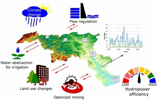
2.1. Study Area
2.2. Materials
2.3. Methods
3. Results
4. Discussion
5. Conclusions
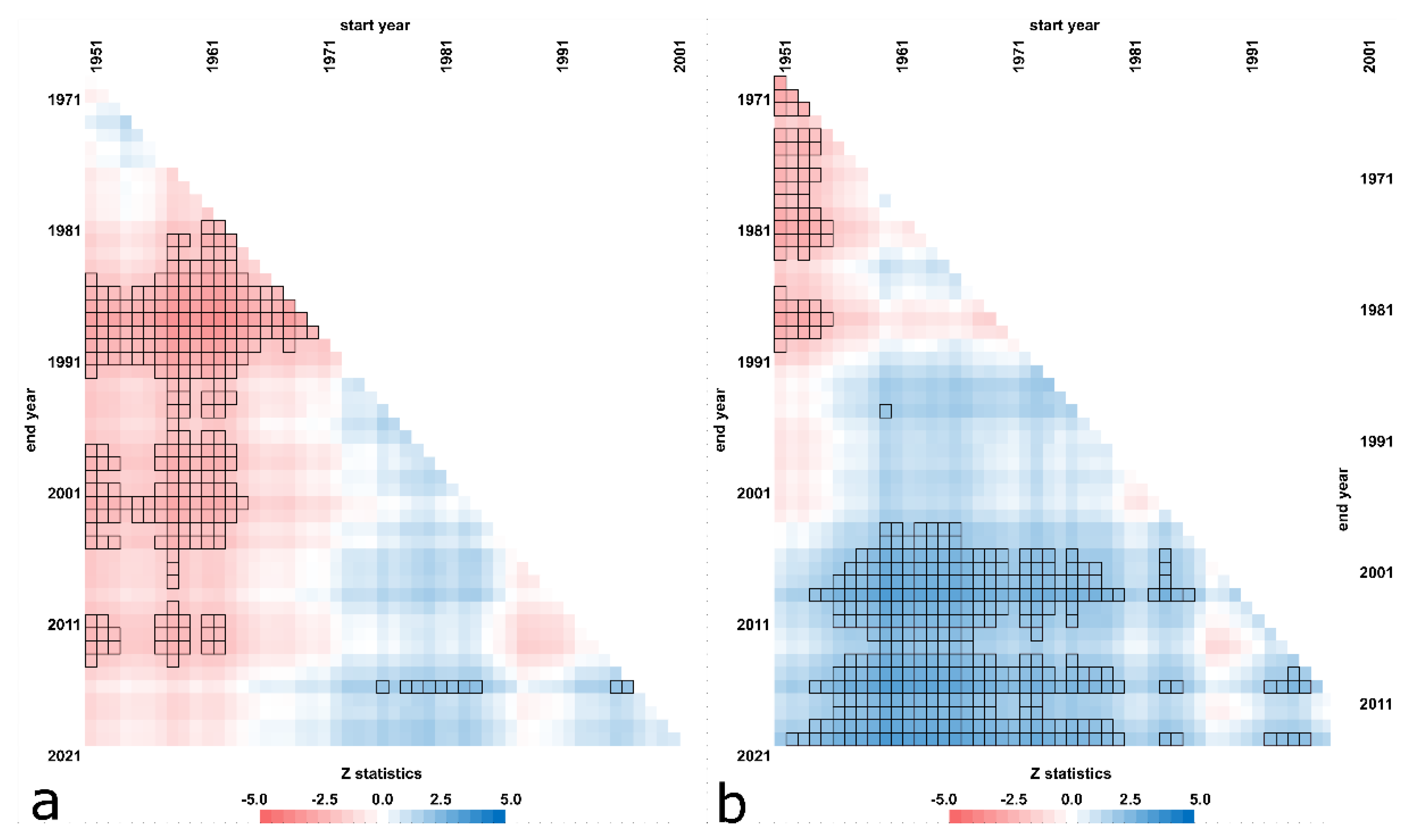
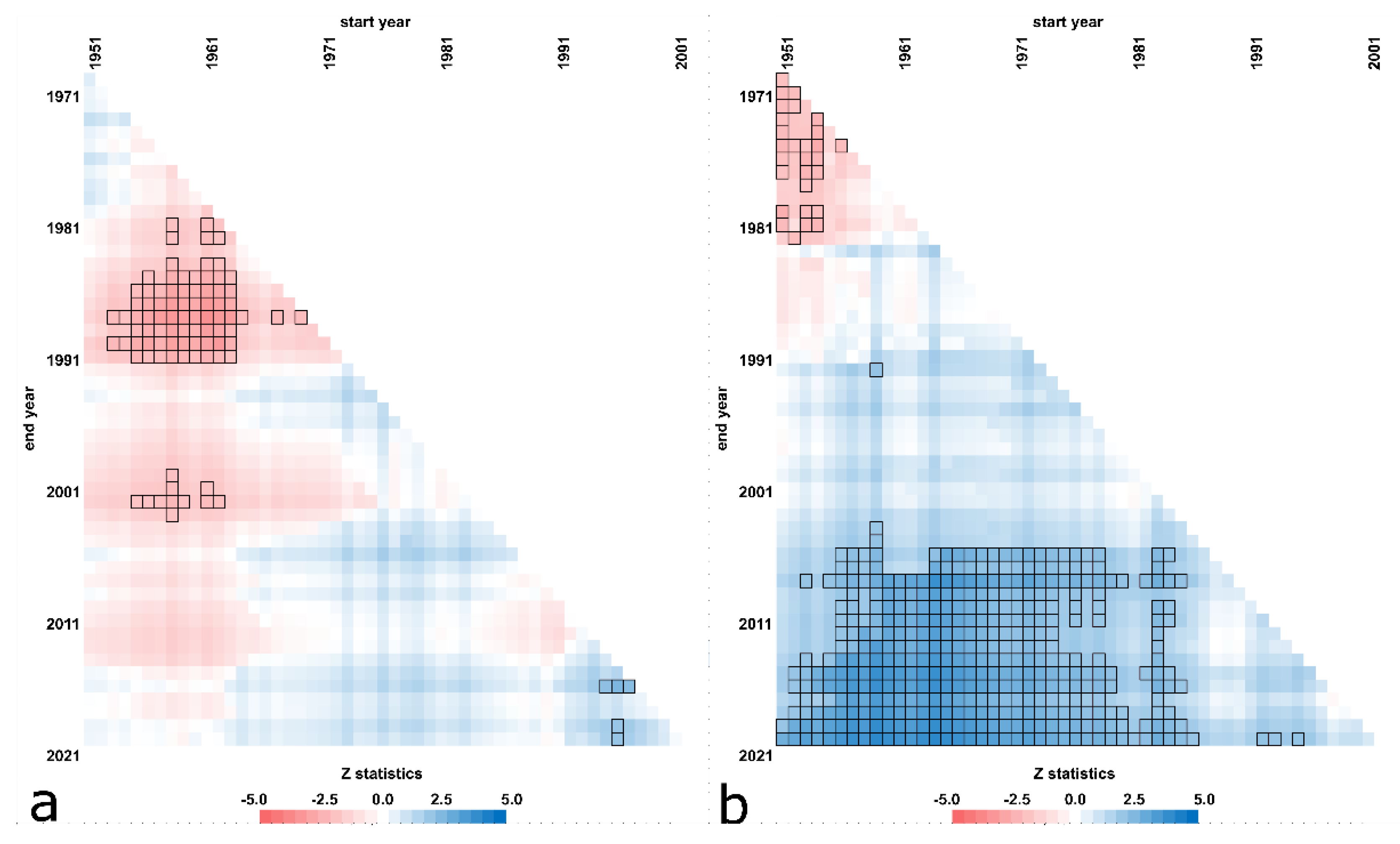
- The analysis of multiannual flow sequences from the years 1951–2020 showed that the changes varied over the time periods and catchments.
- It was established that local factors, mainly of an anthropogenic nature, play a dominant role in the shaping of river flows in both positive and negative terms for the efficiency of the hydropower sector.
- The most significant changes occurred in the low flows and the least significant in the high flows. From the point of view of the operation of the hydropower sector, these changes may be unfavorable and result in a reduction in the efficiency of run-of-river hydropower plants.
- The multitemporal trend analysis indicates a dominant downward trend in low and mean flows. It is also important to note that the trend was particularly pronounced over the last 30 years.
- The results show that the number of days with flows below Q90% tended to increase over the years. While these changes are usually not statistically significant, they can result in increased downtime of run-of-river hydropower plants.
- The analysis of changes in the flow indicators against the background of the catchment’s landform, hydrographic network and land cover did not find them to be dominant. In general, changes in flows are caused by the influence of a number of factors, predominantly by those of anthropogenic nature, together with changes in climatic conditions and the variability of natural factors.
- The multitemporal trend analysis gives a more comprehensive understanding of the influence of the length of the data series and the data span on the obtained results.
- The analysis of long-term historical data series is important for the planning, design, operation and economic efficiency of investments related to run-of-river hydropower plants.
Supplementary Materials
Funding
Institutional Review Board Statement
Informed Consent Statement
Data Availability Statement
Conflicts of Interest
References
- Schaeffer, R.; Szklo, A.S.; de Lucena, A.F.P.; Borba, B.S.M.C.; Nogueira, L.P.P.; Fleming, F.P.; Troccoli, A.; Harrison, M.; Boulahya, M.S. Energy sector vulnerability to climate change a review. Energy 2012, 38, 1–12. [Google Scholar] [CrossRef]
- Tomczyk, P.; Wiatkowski, M. Challenges in the development of hydropower in selected European countries. Water 2020, 12, 3542. [Google Scholar] [CrossRef]
- Wagner, B.; Hauer, C.; Habersack, H. Current hydropower developments in Europe. Curr. Opin. Environ. Sustain. 2019, 37, 41–49. [Google Scholar] [CrossRef]
- Markoff, M.S.; Cullen, A.C. Impact of climate change on Pacific Northwest hydropower. Clim. Change 2008, 87, 451–469. [Google Scholar] [CrossRef]
- Wang, B.; Liang, X.J.; Zhang, H.; Wang, L.; Wei, Y.M. Vulnerability of hydropower generation to climate change in China: Results based on Grey forecasting model. Energy Policy 2014, 65, 701–707. [Google Scholar] [CrossRef]
- Blenkinsop, S.; Fowler, H.J. Changes in European drought characteristics projected by the PRUDENCE regional climate models. Int. J. Climatol. 2007, 27, 1595–1610. [Google Scholar] [CrossRef]
- Schneider, C.; Laizé, C.L.R.; Acreman, M.C.; Flörke, M. How will climate change modify river flow regimes in Europe? Hydrol. Earth Syst. Sci. 2013, 17, 325–339. [Google Scholar] [CrossRef] [Green Version]
- Gaudard, L.; Gilli, M.; Romerio, F. Climate change impacts on hydropower management. Water Resour. Manag. 2013, 27, 5143–5156. [Google Scholar] [CrossRef] [Green Version]
- Kubiak-Wójcicka, K.; Szczęch, L. Dynamics of Electricity Production against the Backdrop of Climate Change: A Case Study of Hydropower Plants in Poland. Energies 2021, 14, 3427. [Google Scholar] [CrossRef]
- Van Vliet, M.T.; Sheffield, J.; Wiberg, D.; Wood, E.F. Impacts of recent drought and warm years on water resources and electricity supply worldwide. Environ. Res. Lett. 2016, 11, 124021. [Google Scholar] [CrossRef] [Green Version]
- Hanel, M.; Rakovec, O.; Markonis, Y.; Máca, P.; Samaniego, L.; Kyselý, J.; Kumar, R. Revisiting the recent European droughts from a long-term perspective. Sci. Rep. 2018, 8, 1–11. [Google Scholar] [CrossRef] [PubMed]
- Forzieri, G.; Feyen, L.; Rojas, R.; Flörke, M.; Wimmer, F.; Bianchi, A. Ensemble projections of future streamflow droughts in Europe. Hydrol. Earth Syst. Sci. 2014, 18, 85–108. [Google Scholar] [CrossRef] [Green Version]
- Rudd, A.C.; Kay, A.L.; Bell, V.A. National-scale analysis of future river flow and soil moisture droughts: Potential changes in drought characteristics. Clim. Change 2019, 156, 323–340. [Google Scholar] [CrossRef]
- Lehner, B.; Döll, P.; Alcamo, J.; Henrichs, T.; Kaspar, F. Estimating the impact of global change on flood and drought risks in Europe: A continental, integrated analysis. Clim. Change 2006, 75, 273–299. [Google Scholar] [CrossRef]
- Trnka, M.; Balek, J.; Zahradníček, P.; Eitzinger, J.; Formayer, H.; Turňa, M.; Brázdil, R. Drought trends over part of Central Europe between 1961 and 2014. Clim. Res. 2016, 70, 143–160. [Google Scholar] [CrossRef] [Green Version]
- Arnell, N.W. The effect of climate change on hydrological regimes in Europe: A continental perspective. Glob. Environ. Change 1999, 9, 5–23. [Google Scholar] [CrossRef]
- Stahl, K.; Tallaksen, L.M.; Hannaford, J.; Van Lanen, H.A.J. Filling the white space on maps of European runoff trends: Estimates from a multi-model ensemble. Hydrol. Earth Syst. Sci. 2012, 16, 2035–2047. [Google Scholar] [CrossRef] [Green Version]
- Roudier, P.; Andersson, J.C.; Donnelly, C.; Feyen, L.; Greuell, W.; Ludwig, F. Projections of future floods and hydrological droughts in Europe under a+2C global warming. Clim. Change 2016, 135, 341–355. [Google Scholar] [CrossRef] [Green Version]
- Hamududu, B.; Killingtveit, A. Assessing climate change impacts on global hydropower. Energies 2012, 5, 305–322. [Google Scholar] [CrossRef] [Green Version]
- Gaudard, L.; Romerio, F.; Dalla Valle, F.; Gorret, R.; Maran, S.; Ravazzani, G.; Stoffel, M.; Volonterio, M. Climate change impacts on hydropower in the Swiss and Italian Alps. Sci. Total. Environ. 2014, 493, 1211–1221. [Google Scholar] [CrossRef]
- Van Vliet, M.T.; Vögele, S.; Rübbelke, D. Water constraints on European power supply under climate change: Impacts on electricity prices. Environ. Res. Lett. 2013, 8, 035010. [Google Scholar] [CrossRef] [Green Version]
- Tobin, I.; Greuell, W.; Jerez, S.; Ludwig, F.; Vautard, R.; Van Vliet, M.T.H.; Breón, F.M. Vulnerabilities and resilience of European power generation to 1.5 °C, 2 °C and 3 °C warming. Environ. Res. Lett. 2018, 13, 044024. [Google Scholar] [CrossRef]
- Lehner, B.; Czisch, G.; Vassolo, S. The impact of global change on the hydropower potential of Europe: A model-based analysis. Energy Policy 2005, 33, 839–855. [Google Scholar] [CrossRef]
- Teotónio, C.; Fortes, P.; Roebeling, P.; Rodriguez, M.; Robaina-Alves, M. Assessing the impacts of climate change on hydropower generation and the power sector in Portugal: A partial equilibrium approach. Renew. Sustain. Energy Rev. 2017, 74, 788–799. [Google Scholar] [CrossRef]
- Chernet, H.H.; Alfredsen, K.; Killingtveit, Å. The impacts of climate change on a Norwegian high-head hydropower system. J. Water Clim. Change 2013, 4, 17–37. [Google Scholar] [CrossRef]
- Savelsberg, J.; Schillinger, M.; Schlecht, I.; Weigt, H. The impact of climate change on Swiss hydropower. Sustainability 2018, 10, 2541. [Google Scholar] [CrossRef] [Green Version]
- Rottler, E.; Francke, T.; Bürger, G.; Bronstert, A. Long-term changes in central European river discharge for 1869–2016: Impact of changing snow covers, reservoir constructions and an intensified hydrological cycle. Hydrol. Earth Syst. Sci. 2020, 24, 1721–1740. [Google Scholar] [CrossRef] [Green Version]
- Stahl, K.; Hisdal, H.; Hannaford, J.; Tallaksen, L.M.; Van Lanen, H.A.J.; Sauquet, E.; Demuth, S.; Fendekova, M.; Jódar, J. Streamflow trends in Europe: Evidence from a dataset of near-natural catchments. Hydrol. Earth Syst. Sci. 2010, 14, 2367–2382. [Google Scholar] [CrossRef] [Green Version]
- Marx, A.; Kumar, R.; Thober, S.; Rakovec, O.; Wanders, N.; Zink, M.; Wood, E.F.; Pan, M.; Sheffield, J.; Samaniego, L. Climate change alters low flows in Europe under global warming of 1.5, 2 and 3 °C. Hydrol. Earth Syst. Sci. 2018, 22, 1017–1032. [Google Scholar] [CrossRef] [Green Version]
- Adynkiewicz-Piragas, M.; Miszuk, B. Risk analysis related to impact of climate change on water resources and hydropower production in the Lusatian Neisse River basin. Sustainability 2020, 12, 5060. [Google Scholar] [CrossRef]
- Piniewski, M.; Szczesniak, M.; Mezghani, A.; Kundzewicz, Z.W. Hydroclimatic projections for the Upper Vistula Basin. In Flood Risk in the Upper Vistula Basin; GeoPlanet: Earth and Planetary Sciences; Kundzewicz, Z.W., Stofel, M., Niedźwiedź, T., Wyżga, B., Eds.; Springer: Berlin/Heidelberg, Germany, 2016; pp. 331–339. [Google Scholar]
- Piniewski, M.; Szcześniak, M.; Kundzewicz, Z.W.; Mezghani, A.; Hov, Ø. Changes in low and high flows in the Vistula and the Odra basins: Model projections in the European-scale context. Hydrol. Process. 2017, 31, 2210–2225. [Google Scholar] [CrossRef]
- Romanowicz, R.J.; Kundzewicz, Z.W.; Meresa, H.K.; Stoffel, M.; Krysanova, V.; Doroszkiewicz, J. Projections of changes in flood hazard in two headwater catchments of the Vistula in the context of European-scale studies. In Flood Risk in the Upper Vistula Basin; GeoPlanet: Earth and Planetary Sciences; Kundzewicz, Z.W., Stofel, M., Niedźwiedź, T., Wyżga, B., Eds.; Springer: Berlin/Heidelberg, Germany, 2016; pp. 341–359. [Google Scholar]
- Berghuijs, W.R.; Hartmann, A.; Woods, R.A. Streamflow sensitivity to water storage changes across Europe. Geophys. Res. Lett. 2016, 43, 1980–1987. [Google Scholar] [CrossRef] [Green Version]
- Lehner, B.; Döll, P. Europe’s Droughts Today and in the Future. Eurowasser–Model-Based Assessment of European Water Resources and Hydrology in the Face of Global Change; Kassel World Water Series; Report No, 5.; University of Kassel: Kassel, Germany, 2001; pp. 1–16. [Google Scholar]
- Cammalleri, C.; Naumann, G.; Mentaschi, L.; Bisselink, B.; Gelati, E.; De Roo, A.; Feyen, L. Diverging hydrological drought traits over Europe with global warming. Hydrol. Earth Syst. Sci. 2020, 24, 5919–5935. [Google Scholar] [CrossRef]
- Klavins, M.; Rodinov, V. Long-term changes of river discharge regime in Latvia. Hydrol. Res. 2008, 39, 33–141. [Google Scholar] [CrossRef] [Green Version]
- Klavins, M.; Rodinov, V.; Timukhin, A.; Kokorīte, I. Patterns of river discharge: Long-term changes in Latvia and the Baltic region. Baltica 2008, 21, 41–49. [Google Scholar]
- Czaja, S. Changes in river discharge structure and regime in mining-industrial-urban areas. Reg. Environ. Change 2005, 5, 18–26. [Google Scholar] [CrossRef]
- Khaliq, M.N.; Ouarda, T.B.; Gachon, P.; Sushama, L. Temporal evolution of low-flow regimes in Canadian rivers. Water Resour. Res. 2008, 44, W08436. [Google Scholar] [CrossRef] [Green Version]
- Poff, N.L.; Allan, J.D.; Bain, M.B.; Karr, J.R.; Prestegaard, K.L.; Richter, B.D.; Sparks, R.E.; Stromberg, J.C. The natural flow regime: A paradigm for river conservation and restoration. BioScience 1997, 47, 769–784. [Google Scholar] [CrossRef]
- Mathews, R.; Richter, B.D. Application of the Indicators of hydrologic alteration software in environmental flow setting 1. J. Am. Water Resour. Assoc. 2007, 43, 1400–1413. [Google Scholar] [CrossRef]
- Rugumayo, A.I.; Ojeo, J. Low Flow Analysis in Lake Kyoga Basin-Eastern Uganda. In Proceedings from the International Conference on Advances in Engineering and Technology; Elsevier Science Ltd.: Amsterdam, The Netherlands, 2006; pp. 739–755. [Google Scholar]
- Searcy, J.K. Flow-Duration Curves-Manual of Hydrology: Part 2’, Low-Flow Techniques; US Geol. Survey Water-Supply Paper; United States Government Printing Office: Washington, DC, USA, 1959; p. 38.
- Kendall, M.G.; Stuart, A. The Advanced Theory of Statistics, 3rd ed.; Charles Griffin Ltd.: London, UK, 1968. [Google Scholar]
- Gilbert, R.O. Statistical Methods for Environmental Pollution Monitorin; Van Nostrand Reinhold Co.: New York, NY, USA, 1987; p. 320. [Google Scholar]
- Yue, S.; Pilon, P.; Phinney, B.; Cavadias, G. The influence of autocorrelation on the ability to detect trend in hydrological series. Hydrol. Process. 2002, 16, 1807–1829. [Google Scholar] [CrossRef]
- Fryzlewicz, P. Wild binary segmentation for multiple change-point detection. Ann. Stat. 2014, 42, 2243–2281. [Google Scholar] [CrossRef]
- McCabe, G.J.; Wolock, D.M. A step increase in streamflow in the conterminous United States. Geophys. Res. Lett. 2002, 29, 38-1–38-4. [Google Scholar] [CrossRef]
- Tomas-Burguera, M.; Beguería, S.; Vicente-Serrano, S.M. Climatology and trends of reference evapotranspiration in Spain. Int. J. Climatol. 2021, 41, E1860–E1874. [Google Scholar] [CrossRef]
- Patakamuri, S.K.; O’Brien, N.M. Modified Versions of Mann Kendall and Spearman’s Rho Trend Tests 2019; The R Project for Statistical Computing: Vienna, Austria, 2019; p. 19. [Google Scholar]
- Baranowski, R.; Fryzlewicz, P. Wild Binary Segmentation for Multiple Change-Point Detection. Version 1.4. 2019. Available online: https://cran.r-project.org/web/packages/wbs/wbs.pdf (accessed on 24 November 2021).
- Ptak, M.; Sojka, M.; Choiński, A.; Nowak, B. Effect of environmental conditions and morphometric parameters on surface water temperature in Polish lakes. Water 2018, 10, 580. [Google Scholar] [CrossRef] [Green Version]
- Wachowiak, G.; Galiniak, G.; Jończyk, W.; Martyniak, R. Assessment of outflow changes in the catchment of the Widawka River in the hydrological year 2010 under the impact of a mining and energy project in the Bełchatów region. Górnictwo Geoinżynieria 2011, 35, 381–395. (In Polish) [Google Scholar]
- Przybyłek, J. Environmental conditions of the effects of opencast brown coal exploitation in the Gniezno Lakeland. Prz. Geol. 2020, 68, 645–654. (In Polish) [Google Scholar]
- Kundzewicz, Z.W. (Ed.) Changes in Flood Risk in Europe; Special IAHS Publication: Oxfordshire, UK, 2012; p. 516. [Google Scholar]
- Madsen, H.; Lawrence, D.; Lang, M.; Martinkova, M.; Kjeldsen, T.R. Review of trend analysis and climate change projections of extreme precipitation and floods in Europe. J. Hydrol. 2014, 519, 3634–3650. [Google Scholar] [CrossRef] [Green Version]
- Piniewski, M.; Marcinkowski, P.; Kundzewicz, Z.W. Trend detection in river flow indices in Poland. Acta Geophys. 2018, 66, 347–360. [Google Scholar] [CrossRef] [Green Version]
- Górnik, M. Changing trends of river flows in the Upper Vistula basin (East-Central Europe). Acta Geophys. 2020, 68, 495–504. [Google Scholar] [CrossRef] [Green Version]
- Parajka, J.; Kohnová, S.; Merz, R.; Szolgay, J.; Hlavčová, K.; Blöschl, G. Comparative analysis of the seasonality of hydrological characteristics in Slovakia and Austria. Hydrolog. Sci. J. 2009, 54, 456–473. [Google Scholar] [CrossRef]
- Wrzesiński, D. Reżim rzek Polski. In Hydrologia Polski; Jokiel, P., Marszelewski, W., Pociask-Karteczk, J., Eds.; Wyd. Nauk. PWN: Warszawa, Poland, 2017; pp. 215–222. (In Polish) [Google Scholar]
- Wrzesiński, D.; Sobkowiak, L. Detection of changes in flow regime of rivers in Poland. J. Hydrol. Hydromech. 2018, 66, 55–64. [Google Scholar] [CrossRef] [Green Version]
- Alves Dias, P.; Kanellopoulos, K.; Medarac, H.; Kapetaki, Z.; Miranda-Barbosa, E.; Shortall, R.; Czako, V.; Telsnig, T.; Vazquez-Hernandez, C.; Lacal Arántegui, R.; et al. EU Coal Regions: Opportunities and Challenges Ahead; European Commission, Joint Research Centre: Petten, The Netherlands, 2018. [Google Scholar]
- Tramblay, Y.; Rutkowska, A.; Sauquet, E.; Sefton, C.; Laaha, G.; Osuch, M.; Albuquerque, T.; Alves, M.H.; Banasik, K.; Beaufort, A.; et al. Trends in flow intermittence for European rivers. Hydrol. Sci. J. 2021, 66, 37–49. [Google Scholar] [CrossRef]
- Klavins, M.; Briede, A.; Rodinov, V. Long term changes in ice and discharge regime of rivers in the Baltic region in relation to climatic variability. Clim. Change 2009, 95, 485–498. [Google Scholar] [CrossRef]
- Kędra, M. Long-term trends in river flow: A case study of the Soła River (Polish Carpathians). E3S Web Conf. 2017, 19, 02012. [Google Scholar] [CrossRef] [Green Version]
- Hannaford, J.; Buys, G. Trends in seasonal river flow regimes in the UK. J. Hydrol. 2012, 475, 158–174. [Google Scholar] [CrossRef] [Green Version]
- Banasik, K.; Hejduk, L.; Hejduk, A.; Kaznowska, E.; Banasik, J.; Byczkowski, A. Long-term variability of runoff from a small catchment in the region of the Kozienice Forest. Sylwan 2013, 157, 578–586. [Google Scholar]
- Somorowska, U. Climate-driven changes to streamflow patterns in a groundwater-dominated catchment. Acta Geophys. 2017, 65, 789–798. [Google Scholar] [CrossRef] [Green Version]
- Zeleňáková, M.; Purcz, P.; Soľáková, T.; Demeterová, B. Analysis of trends of low flow in river stations in eastern Slovakia. Acta Univ. Agric. Silvic. Mendel. Brun. 2012, 60, 265–274. [Google Scholar] [CrossRef] [Green Version]
- Kolendowicz, L.; Czernecki, B.; Półrolniczak, M.; Taszarek, M.; Tomczyk, A.M.; Szyga-Pluga, K. Homogenization of air temperature and its long-term trends in Poznań (Poland) for the period 1848–2016. Theor. Appl. Climatol. 2019, 136, 1357–1370. [Google Scholar] [CrossRef] [Green Version]
- Hannaford, J.; Buys, G.; Stahl, K.; Tallaksen, L.M. The influence of decadal-scale variability on trends in long European streamflow records. Hydrol. Earth Syst. Sci. 2013, 17, 2717–2733. [Google Scholar] [CrossRef] [Green Version]
- Majone, B.; Villa, F.; Deidda, R.; Bellin, A. Impact of climate change and water use policies on hydropower potential in the south-eastern Alpine region. Sci. Total. Environ. 2016, 543, 965–980. [Google Scholar] [CrossRef] [PubMed]
- Malczewska, B. Variability of water energy resources on example of Bóbr river. Infrastrukt. Ekol. Teren. Wiej. 2010, 13, 167–177. (In Polish) [Google Scholar]
- Młyński, D.; Operacz, A.; Wałęga, A. Sensitivity of methods for calculating environmental flows based on hydrological characteristics of watercourses regarding the hydropower potential of rivers. J. Clean. Prod. 2020, 250, 119527. [Google Scholar] [CrossRef]


| No | River | Station | Abbreviation | Catchment Area | Location | |
|---|---|---|---|---|---|---|
| Altitude | Longitude | |||||
| 1 | Ner | Dąbie | ND | 1727.21 | 52°05′05″ N | 18°49′26″ E |
| 2 | Mała Noteć | Gębice | MG | 217.75 | 52°36′02″ N | 18°02′01″ E |
| 3 | Grabia | Grabno | GG | 807.98 | 51°27′30″ N | 18°59′07″ E |
| 4 | Widawka | Rogóźno | WR | 1271.25 | 51°26′08″ N | 18°58′27″ E |
| 5 | Niesób | Kuźnica Skakawska | NK | 243.00 | 51°16′47″ N | 18°07′54″ E |
| 6 | Prosna | Bogusław | PB | 4282.38 | 51°53′54″ N | 17°57′13″ E |
| 7 | Mogilnica | Konojad | MK | 719.39 | 52°09′04″ N | 16°31′56″ E |
| 8 | Sama | Szamotuły | SS | 397.34 | 52°36′44″ N | 16°34′53″ E |
| 9 | Drawa | Drawsko Pomorskie | DD | 592.49 | 53°31′37″ N | 15°48′39″ E |
| 10 | Oleśnica | Niechmirów | ON | 595.77 | 51°23′17″ N | 18°45′44″ E |
| 11 | Wełna | Pruśce | WP | 1139.74 | 52°46′23″ N | 17°05′54″ E |
| 12 | Gwda | Piła | GP | 4725.67 | 53°09′05″ N | 16°44′25″ E |
| 13 | Flinta | Ryczywół | FR | 283.07 | 52°48′59″ N | 16°50′22″ E |
| 14 | Ołobok | Ołobok | OO | 444.68 | 51°38′22″ N | 18°04′08″ E |
| Parameter | Number of Parameters | Description |
|---|---|---|
| Monthly low, mean and high flows | 36 | NovL, DecL, JanL, FebL, MarL, AprL, MayL, JunL, JulL, AugL, SepL, OctL NovM, DecM, JanM, FebM, MarM, AprM, MayM, JunM, JulM, AugM, SepM, OctM NovH, DecH, JanH, FebH, MarH, AprH, MayH, JunH, JulH, AugH, SepH, OctH |
| Half-year minimum, mean and maximum flows | 6 | WHL, WHM, WHH SHL, SHM, SHH |
| Annual minimum, mean and maximum flows | 3 | YL, YM, YH |
| Annual 3 day, 7 day, 30 day and 90 day minima (low flow) | 4 | DL3, DL7, DL30, DL90 |
| Q50, Q70 and Q90% exceedance flow value | 4 | TBQ30%, TBQ50%; TBQ70%, TBQ90% |
| Flow duration between Q50 and Q90% | 1 | TQ5090% |
| Total | 54 |
| No | River (Abbr.) | MALF | MAMF | MAHF | Q30% | Q50% | Q70% | Q90% | MAMLF |
|---|---|---|---|---|---|---|---|---|---|
| 1 | Ner (ND) | 0.410 | 9.86 | 86.0 | 10.50 | 7.55 | 5.56 | 3.40 | 2.46 |
| 2 | Mała Noteć (MG) | 0.003 | 0.59 | 7.47 | 0.70 | 0.45 | 0.29 | 0.13 | 0.15 |
| 3 | Grabia (GG) | 0.380 | 4.12 | 86.0 | 4.14 | 2.74 | 1.80 | 1.11 | 1.09 |
| 4 | Widawka (WR) | 0.670 | 8.22 | 104 | 9.04 | 7.28 | 5.81 | 3.80 | 4.13 |
| 5 | Niesób (NK) | 0.040 | 0.97 | 33.6 | 1.02 | 0.72 | 0.48 | 0.25 | 0.23 |
| 6 | Prosna (PB) | 0.960 | 15.59 | 230 | 16.50 | 11.10 | 7.36 | 4.52 | 3.88 |
| 7 | Mogilnica (MK) | 0.004 | 1.62 | 31.8 | 1.55 | 0.79 | 0.39 | 0.18 | 0.17 |
| 8 | Sama (SS) | 0.014 | 1.04 | 20.5 | 1.07 | 0.63 | 0.32 | 0.14 | 0.16 |
| 9 | Drawa (DD) | 0.378 | 4.04 | 18.8 | 4.70 | 3.47 | 2.54 | 1.59 | 1.59 |
| 10 | Oleśnica (ON) | 0.190 | 2.38 | 70 | 2.33 | 1.49 | 0.97 | 0.58 | 0.56 |
| 11 | Wełna (WP) | 0.028 | 3.31 | 36.9 | 3.60 | 2.25 | 1.34 | 0.66 | 0.77 |
| 12 | Gwda (GP) | 8.200 | 26.85 | 111 | 29.90 | 25.10 | 21.20 | 16.60 | 14.47 |
| 13 | Flinta (FR) | 0.001 | 0.65 | 7.28 | 0.70 | 0.41 | 0.23 | 0.09 | 0.10 |
| 14 | Ołobok (OO) | 0.006 | 1.57 | 33 | 1.56 | 0.92 | 0.54 | 0.28 | 0.25 |
Publisher’s Note: MDPI stays neutral with regard to jurisdictional claims in published maps and institutional affiliations. |
© 2022 by the author. Licensee MDPI, Basel, Switzerland. This article is an open access article distributed under the terms and conditions of the Creative Commons Attribution (CC BY) license (https://creativecommons.org/licenses/by/4.0/).
Share and Cite
Sojka, M. Directions and Extent of Flows Changes in Warta River Basin (Poland) in the Context of the Efficiency of Run-of-River Hydropower Plants and the Perspectives for Their Future Development. Energies 2022, 15, 439. https://0-doi-org.brum.beds.ac.uk/10.3390/en15020439
Sojka M. Directions and Extent of Flows Changes in Warta River Basin (Poland) in the Context of the Efficiency of Run-of-River Hydropower Plants and the Perspectives for Their Future Development. Energies. 2022; 15(2):439. https://0-doi-org.brum.beds.ac.uk/10.3390/en15020439
Chicago/Turabian StyleSojka, Mariusz. 2022. "Directions and Extent of Flows Changes in Warta River Basin (Poland) in the Context of the Efficiency of Run-of-River Hydropower Plants and the Perspectives for Their Future Development" Energies 15, no. 2: 439. https://0-doi-org.brum.beds.ac.uk/10.3390/en15020439