Article

Characteristics of Source Rocks and Formation of Reservoir Bitumen in Yinchuan Graben, Ordos Basin, China

1
Hubei Key Laboratory of Petroleum Geochemistry and Environment, Yangtze University, Wuhan 434023, China
2
PetroChina Changqing Oilfield Company, Xi’an 710018, China
*
Author to whom correspondence should be addressed.
Submission received: 26 April 2022 / Revised: 2 June 2022 / Accepted: 28 June 2022 / Published: 30 June 2022
(This article belongs to the Special Issue Shale Oil and Gas Accumulation Mechanism)

Abstract

:
The Yinchuan Graben is an important potential exploration area that is located on the western margin of the Ordos Basin. Over 8000 m of Cenozoic strata have been formed since the Cretaceous. With an integrated approach of cores observation, logging analysis, and geochemical analysis, we analyzed the characteristics of the Cenozoic source rocks in the Yinchuan Graben and determined the formation and destruction of the fossil oil reservoirs. With type III kerogen, the TOC of the dark mudstone in the Qingshuiying Formation is up to 7.5%, and the Ro is 0.95–1.04%, indicating the source rocks have entered the mature stage but the hydrocarbon generation potential is insufficient. A quantity of reservoir bitumen and oil-bearing fluid inclusions (GOI = 1.67–4%) were found in the Qingshuiying Formation sandstone in Well YQ-1, which indicates a fossil oil reservoir had existed. The fossil oil reservoir and reservoir bitumen were generated by the unexplored pre-Cenozoic strata in the Yinchuan Graben. The reservoir bitumen has high maturity and is associated with many fluid inclusions with a high homogenization temperature or CO2. This indicates that the bitumen was formed by the pyrolysis of the oil which was caused by the hot fluid migrating along with the deep fault belts.

1. Introduction

Studying the characteristics of source rocks is the basis of oil and gas evaluation. It can help to reveal the formation, distribution, and characteristics of oil and gas reservoirs. Dembicki et al. [1] integrated the pyrolysis results and thickness data of source rocks and forecasted the distribution characteristics of potential hydrocarbon generation in the Bakken shale. Gao et al. [2] investigated the source rocks of different oil reservoirs in the Nanpu Sag, Bohaiwan Basin, through GC-MS and oil–source correlation. Lomando [3], Zhao and Machel [4], and Kim et al. [5] all considered that reservoir bitumen has a great influence on reservoir quality and the exploration of oil. The Alberta province of Canada, North America, and the Sichuan Basin [6,7,8] all have explored huge reserves of heavy oil and bitumen resources. The characteristics of source rocks and reservoir bitumen can reflect the formation environment and preservation condition of hydrocarbon reservoirs in petroliferous basins.
The Yinchuan Graben is a favorable oil and gas exploration area in western China. Studying the petroleum geological characteristics of the Yinchuan Graben is helpful to the further the development of oil resources in western China. Rift basins often have favorable formation conditions for oil–gas reservoirs. Sedimentary facies like delta fans or lakes are always deposited in the depressions of the rift basins, such as the Bohaiwan Basin [9,10,11,12,13,14], the Junggar Basin [15,16], and the Songliao Basin [17,18]. The Yinchuan Graben is a typical rift basin located in the western margin of the Ordos Basin which has complex structures and thick sediment. However, current research aiming at the Yinchuan Graben mainly focuses on tectonics, sedimentology, and paleoclimate restoration [19,20,21,22,23,24,25,26]. Wang et al. [27] considered that the Yinchuan Graben experienced three regional tectonic sedimentary events from Pliocene to Quaternary by the paleomagnetic data from boreholes. Jing et al. [28] considered that the Yinchuan Graben and Helan Mountain are a typical basin-and mountain-structure; the interaction of the deep faults in the Yinchuan Graben causes frequent earthquakes. However, there are only three pre-exploratory wells (Well YC-1, Well YC-3, Well YC-4, Well YQ-1) that have weak hydrocarbon shows. Because the exploration in the Yinchuan Graben since 2011 has been weak, the characteristics of the hydrocarbon accumulation are still unclear. Hao et al. [29] analyzed the characteristics of the source rocks in the Yinchuan Graben and pointed out that hydrocarbon generation and accumulation had happened in the Yinchuan Graben, but the hydrocarbon generation potential, provenance, and formation environment of the source rocks are still unknown. More evidence should be provided to prove hydrocarbon generation and accumulation. Well YQ-1 was deployed in the Yinchuan Graben by CNPC Changqing Petroleum in 2019. Combined with the geological, logging, and geochemical analysis data of Well YQ-1, this paper describes the fossil oil reservoir in the Yinchuan Graben for the first time. Based on clarifying the sedimentary characteristics, we analyzed the characteristics of the source rocks and the evolution of the reservoir bitumen and fossil oil reservoirs in the Yinchuan Graben by analyzing the data of a geochemical experiment and the fluid inclusion temperature. Rift basins usually have high geothermal gradients, and the study of the characteristics of source rocks, the formation model of fossil oil reservoirs, and reservoir bitumen in the Yinchuan Graben can indicate how the regional geologic structures of the Yinchuan Graben influence the geothermal gradient, source rocks, and oil reservoirs in the basin.

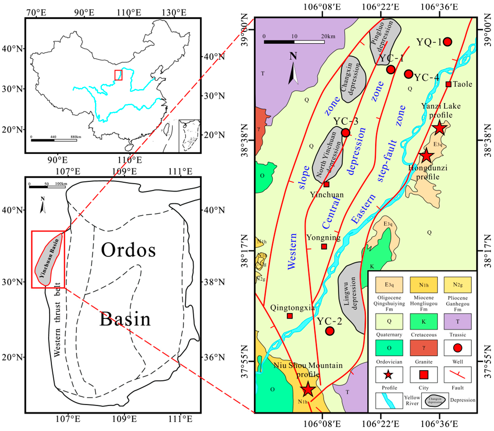
2. Geological Setting

The Yinchuan Graben is distributed in the NE–SW direction; the NE length of the basin is over 180 km, and the width of the basin is 42–60 km. The Yinchuan Graben is one of the Cenozoic rift basins in the western margin of the Ordos Basin. Helan Mountain, Niushou Mountain, and Zhuozi Mountain are the western, southern, and northern basin boundaries (Figure 1) [21,22,24,30,31]. The periphery of the basin is controlled by faults, and several deep faults extend from east or west to the middle of the basin. The Yinchuan Graben can be divided into three parts: the eastern fault terrace slope area, the central depression area, and the western slope area [19,29]. The basin has four sedimentary centers: the Pingluo Depression, Changxin Depression, North Yinchuan Depression, and Lingwu Depression from north to south (Figure 1).
Paleozoic and pre-Paleozoic strata form the basin basement of the Yinchuan Graben [19]. The Oligocene Qingshuiying Formation, Miocene Hongliugou Formation, and Pliocene Ganhegou Formation are developed from bottom to top (Figure 2). The Oligocene Qingshuiying Formation mainly deposited lacustrine sediments and has two sedimentary cycles. The lower cycle is red sandstone, and the conglomerate turns to mudstone interbed with siltstone. The upper cycle is red fine sandstone which turns to mudstone interbed with sandstone and gypsum. The lacustrine sediment of the Miocene Hongliugou Formation is grayish-white interbed with light yellow fine sandstone or pebbly sandstone and brownish-red mudstone layers of different thicknesses, the middle and lower part of the strata interbed with marlite and gypsum. The sedimentary of the Hongliugou Formation are braided river facies. The sediment of the Pliocene Ganhegou Formation are fluvial facies and unconformity covers the strata of the Hongliugou Formation. The lithology is light brown, gray, and beige pebbly sandstone interbed with brown-yellow and purple-red mudstone; some strata contain charcoal and particles of pyrite, hematite, and gypsum.

3. Material and Methods

We mainly carried out petrographic observation, organic geochemical testing, observation under the optical microscope, and fluid inclusion thermometry testing. The analysis and test were carried out by the Hubei Key Laboratory of “Oil and Gas Geochemistry and Environment”. There are 14 brownish-gray mudstone samples with sampling depths from 3743.4 to 3746.6 m for geochemical analysis. The sampling depths of the samples for fluid inclusions and reservoir bitumen analysis are light brown calcite bearing quartz sandstone from 3749.6 m and brownish-red quartz sandstone from 4248.45 and 4249.9 m. See Figure 2 for specific depth. All samples are from Well YQ-1; see Figure 1 for the drill location.
Problems often need to be considered comprehensively in geological research [32]. Rock-Eval pyrolysis, extraction of chloroform asphalt “A”, and GC-MS are always used to study the maturity, kerogen types, and hydrocarbon generation ability of source rock samples [33], and we also used Laser Raman spectrum experiment and GC-MS to study the maturity and provenance of reservoir bitumen. We measured the homogenization temperature of inclusions to study the origin of the fossil oil reservoir.
The core samples were crushed and filtered. Pyrolysis of source rock was carried out by the oil and gas evaluation workstation (OGE-VI). Finally, we obtain the data of vitrinite reflectance, maximum pyrolysis temperature, total hydrocarbon content, and hydrogen index of source rocks. The core samples were crushed, and organic matter was extracted by organic solvent. Then, it was analyzed by gas chromatography and mass spectrometry (GC-MS) (GC 6890/5973 MSD). Through the experiment, we obtained the composition and content of biomarkers in source rock samples, and we determined the provenance of the source rocks after calculation.
We sliced the reservoir bitumen samples and used the Laser Raman fluorescence spectrometer to obtain the distribution curves of the spectrum. We calculated the maturity of the reservoir bitumen from the curves. The experimental operation of GC-MS is the same as that of source rock samples. We sliced the sandstone reservoir samples. We used the optical microscope to observe the characteristics of reservoir bitumen and the fluorescence of oil-bearing inclusions under the environment of ultraviolet radiation. We used the heating/cooling stage (THMSG 600) to measure the homogenization temperature of fluid inclusions. Different colors of the fluorescence of oil bearing indicate oil and gas filling in different periods [34], and the homogenization temperature can reflect the formation environment of fluid inclusions [35]. By analyzing the above data, we can restore the formation and damage environment and mode of the fossil oil reservoir.

4. Results and Discussion

4.1. Characteristics of Source Rocks and Reservoir Bitumen

The thickness of the Qingshuiying Formation in Well YC-1 is 648 m (not through) with 80% mudstone. The TOC of the Qingshuiying Formation is 0.09–0.67% with an average of 0.4%. The TOC of Well YC-2 and Well YC-3, which have no hydrocarbon generation potential, is 0.03–0.13%. A geochemical analysis was carried out on source rock samples from the Qingshuiying Formation at depths of 3743.4, 3743.8, 3745.47, and 3746.16 m in Well YQ-1 (Table 1). With a TOC of 3.6–12.7% and a Ro of 0.95–1.04%, both of them reach a maximum at 3745.47 m whose lithology is greenish-gray dolomitic mudstone. The samples from 3743.8 and 3746.16 m in Well YQ-1 are poor source rocks and the others are very poor source rocks. The IH of the samples is 1.24–4.31 mg/g; all samples are type III kerogen. With a Ro of 0.92–1.04%, an OEP of 0.76–0.97, and a maximum pyrolysis temperature of 442–447 °C, the organic matter in the Qingshuiying Formation of Well YQ-1 has entered the mature stage. With high organic matter content, the hydrocarbon generation ability of the mudstone in the Qingshuiying Formation, Well YQ-1, is insufficient.
The Qingshuiying Formation strata in the Yinchuan Graben from the depth of 3204 to 3277 m has the hydrocarbon generation ability and can be the position of potential source rocks to develop. Hao et al. [29] analyzed the logging, organic geochemistry, and seismic data and considered that the threshold depths of oil generation in the Qingshuiying Formation is 3110–3310 m. The source rocks will generate oil in an enormous quantity at 4700 m depth. Because the Bouguer gravity anomaly areas of the Yinchuan Graben are distributed in four subsidence depressions (Figure 3a) [31], according to the evolutionary process of the Yinchuan Graben [36], we considered that the Qingshuiying Formation strata are thicker in the depressions (Figure 3b). The Changxin depression and the Pingluo depression have thicker dark mudstone in the Qingshuiying Formation strata than the North Yinchuan depression and the Lingwu depression located in the south of the basin. It indicates that finding dark mudstone is more likely in the Qingshuiying Formation strata whose buried depth reaches the oil generation threshold depth in the north of the Yinchuan Graben. Thus, the oil generation potential of the dark mudstone in the Qingshuiying Formation strata in the north of the Yinchuan Graben is higher than that in the south.
Gas chromatograms of saturated hydrocarbons were carried out on the 14 source rock samples from Well YQ-1 at the depths of 3743.4–3746.16 m. See Figure 2 for the sampling location; the results are shown in Figure 4 and Figure 5. The source rocks of Well YQ-1 are mainly deposited in the lacustrine reduction surroundings and transitional surroundings, and the provenances of the organic matters are terrestrial (Figure 5). The characteristics of the gas chromatography are shown in Figure 4. The peak of the total ion current is near the end, indicating the organic matter mainly contains heavier n-alkane. The ratio of the tricyclic terpene C25/C26 is less than 1, and the shape of the curve of the C25-C28-C29 sterane is like the letter V, indicating that the provenance of the source rock samples in Well YQ-1 is the humic terrestrial higher plant.
Laser Raman spectroscopic analyses were carried out on the massive reservoir bitumen from the depth of 4248.5 and 4249.9 m of Well YQ-1; see Table 2 and Figure 6 for the results. When the Ro is over 1.5%, the reservoir bitumen will show obvious anisotropy, and the mean ratio of the Ro is about 2.134%. Hanson et al. considered that the source rocks in the western part of the basin are more thermally mature than those in the east [37]. Thus, we considered that the reservoir bitumen in the Yinchuan Graben has high maturity.

4.2. Characteristics of Fluid Inclusions

The oil-bearing fluid inclusions that were fluorescent were observed under ultraviolet irradiation in calcite crystalline grains at the depth of 3749.96 m, Well YQ-1 (Figure 7a). We considered that there are at least two periods of hydrocarbon charging that had happened in Well YQ-1 according to different fluorescent colors (Figure 7e–h). However, due to too few synchronous saltwater inclusions, we could not measure the effective data. Oil-bearing fluid inclusions with yellow-green fluorescent with a GOI of 1.67% were observed in the intragranular crackles of the quartz grains at the depth of 4248.5 m, which indicates a palaeoaquifer. Oil-bearing fluid inclusions with blue fluorescent with a GOI of 4.0% were observed in the intragranular crackles of the quartz grains at the depth of 4249.9 m, which indicates a paleo oil-bearing bed [38]. Hao et al. [29] considered that the Qingshuiying Formation dark mudstone would generate oil and gas in an enormous quantity at the depth of 4700 m, but Well YQ-1 did not drill to enough depth so the mudstone in the Qingshuiying Formation cannot generate oil. Thus, the source rocks of the fossil oil reservoir cannot be Qingshuiying Formation dark mudstone. We considered that unexplored source rocks exist in the deeper strata of the basin.

4.3. Formation Process of Fossil Oil Reservoir and Reservoir Bitumen

Well YQ-1 drills through the Qingshuiying Formation strata, and the end of the drill is light red granite gneiss without the hydrocarbon generating capacity. According to the formation and evolution characteristics [36], residual pre-Cenozoic strata with several hydrocarbon generation abilities exist underneath the Qingshuiying Formation (Figure 8a). These strata have generated oil after the Qingshuiying Formation had been deposited. Oil migrated near Well YQ-1 and formed oil-bearing fluid inclusions with different maturities after several periods of hydrocarbon charging (Figure 8b).
Reservoir bitumen has several formations, including pyrolysis, biodegradation, water washing, and gravity differentiation [39]. The maturity of the reservoir bitumen in the Yinchuan Graben is similar to the pyrobitumen formed by pyrolysis in the upper Triassic strata of the Sichuan Basin [40]. Massive or banded reservoir bitumen is filled in the intergranular porosity of the sandstone from top to bottom in the Qingshuiying Formation (Figure 7g,h) [41], and any marker for being biologically degraded was not found by CG-MS. These phenomena indicate that biodegradation, gravity differentiation, or water washing cannot be the origin of the reservoir bitumen in the Yinchuan Graben. Thus, we considered that the reservoir bitumen in the Qingshuiying Formation in Well YQ-1 was formed by the pyrolysis of the crude oil. Additionally, predecessors did not find any gas reservoirs in the Yinchuan Graben; the gas formed by pyrolysis might have been lost without suitable save conditions.
The average geothermal gradient of the Yinchuan Graben is 3 °C/hm [31], which is not enough for the formation of the oil pyrolysis. However, the Yinchuan Graben has a shallow depth of the Moho Surface [42]. The attenuation of the lithosphere and the upward migration of the mantle asthenosphere causes the Yinchuan Graben to have a high ground temperature [43] (Figure 8c). According to the previous studies, the geothermal distribution characteristics of the Yinchuan Graben are closely related to the faults [44]. The east of Well YQ-1 is the deep fault zone named the Huanghe Fault of Yinchuan Graben. The depth of the Huanghe Fault zone is close to the Moho Surface. Predecessors believe that it provides a channel for the upward migration of deep hydrothermal fluids [44]. We also found a large amount of gas–liquid two-phase aqueous fluid inclusions with a homogenization temperature over 200 °C and CO2-bearing fluid inclusions during the microscopic observation of the sandstone samples, indicating that the ground temperature of the Qingshuiying Formation strata in Well YQ-1 had once abnormally elevated. Due to the failure to measure effective homogenization temperature data for a fluid inclusion thermodynamic analysis, we cannot judge when the hydrothermal activity had been activated.
Combined with the above evidence, this paper only speculates the formation mode of reservoir bitumen, as shown in Figure 8. Because Well YQ-1 did not drill to the pre-Cenozoic strata, crude oil generated from the pre-Cenozoic strata underneath the Qingshuiying Formation may charge after the migration (Figure 8a,b). During the basin formation process, the Yinchuan Graben has been affected by the mantle material under the Moho Surface [36], so it is speculated that the hydrothermal fluids have been moving upward along the deep faults after the basin formed (Figure 8a–d). With the increase in burial depth, the ground temperature of the Qingshuiying Formation strata gradually rose and caused the pyrolysis of fossil oil reservoirs (Figure 8c). The pyrolysis of the crude oil formed the reservoir bitumen (Figure 8d).

5. Conclusions

This study mainly evaluates the dark mudstone of the Qingshuiying Formation of the Oligocene in the Yinchuan Graben, describes the fossil oil reservoirs and reservoir bitumen, and summarizes their characteristics. Based on the existing conditions, the damage to fossil oil reservoirs and the formation of reservoir bitumen are speculated. The main achievements of this study are as follows.
(1)
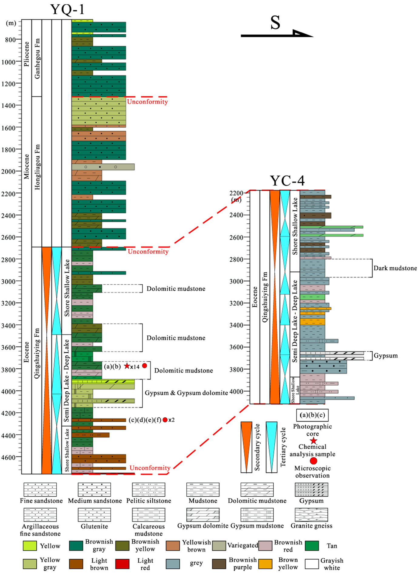
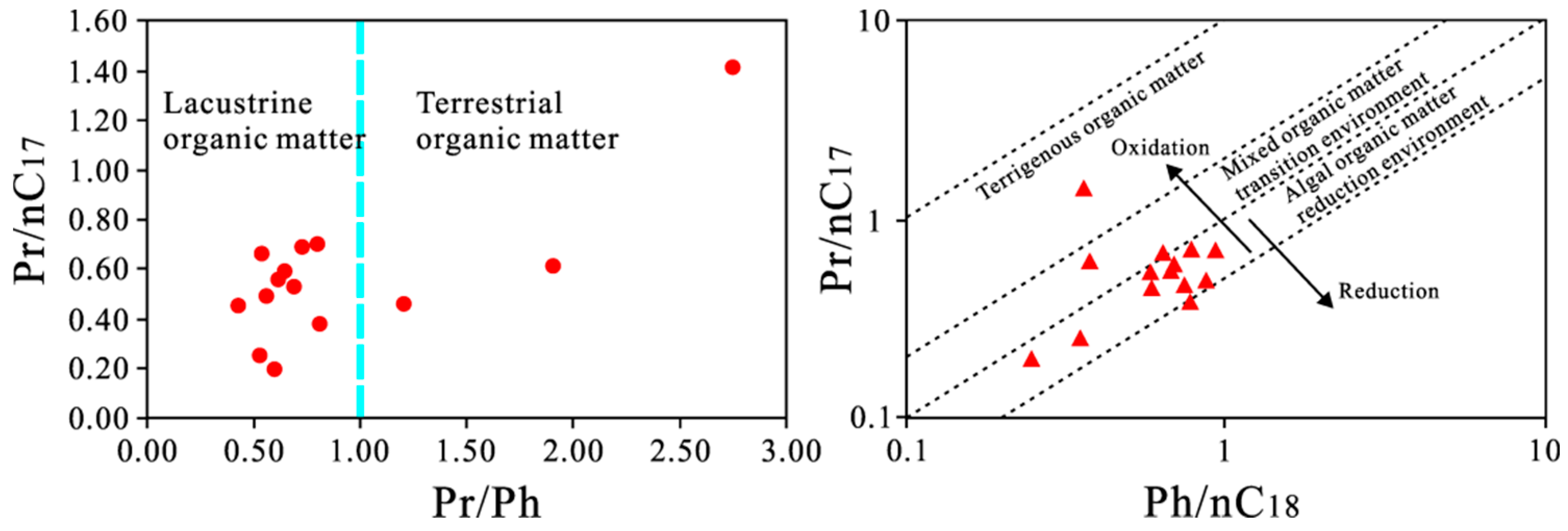
According to the hydrocarbon source evaluation, the only known potential source rock in the Yinchuan Graben is the dark mudstone of the Oligocene Qingshuiying Formation. The overall organic carbon content is high (12.7%), but the hydrocarbon generation potential is poor (the ratio of S1 + S2 is less than 0.3 mg/g). The source rock has entered the mature stage, but the oil generation potential is weak. It is formed by the deposition of terrestrial higher plants in the lacustrine-reducing environment. The dark mudstone of the Qingshuiying Formation is thick in the Pingluo Depression, Changxin Depression, North Yinchuan Depression, and Lingwu Depression of the Yinchuan Graben. The thickness of the dark mudstone in the north of the basin is greater than in the south, and the hydrocarbon generation potential is relatively higher.
(2)
A large amount of oil-bearing fluid inclusions and reservoir bitumen had been found in the source rock samples in Well YQ-1. Reservoir bitumen has high maturity, which is 2.134%, and is formed by oil pyrolysis. The reservoir bitumen has no relationship with the Qingshuiying Formation dark mudstone. This provides more evidence for the hydrocarbon generation and charging in the Yinchuan Graben during geological history.
(3)
Unexplored pre-Cenozoic strata with hydrocarbon generation ability exist underneath the Qingshuiying Formation in the Yinchuan Graben, which might be the source rocks of the fossil oil reservoirs and reservoir bitumen. Gas–liquid two-phase aqueous fluid inclusions with homogenization temperatures over 200 °C indicate that a high ground temperature field had been formed in the Qingshuiying Formation strata. Combined with the fact that the deep faults in the Yinchuan Graben will lead to the upward movement of the deep heat flow from previous studies, we believe that this high-temperature phenomenon is caused by the upward movement of hydrothermal activity along the deep fault. We speculate that in the geological history period, the fossil oil reservoirs in the Qingshuiying Formation experienced pyrolysis to form reservoir bitumen under the influence of hydrothermal activities migrated upward along deep faults.
This study provides more examples for studying the hydrocarbon accumulation characteristics and preservation conditions of Western China Cenozoic rift basins. In addition, due to the limitation of the exploration of the Yinchuan Graben, there are still many conclusions in this paper that need further exploration and research, which also provides more guidance and help on how to explore the Yinchuan Graben deeply in the next step.

Author Contributions

Conceptualization, X.L., J.Y., Y.W., N.W., Q.X. and J.W.; data curation, Q.F., Q.X., J.W. and Y.L.; formal analysis, Q.F., N.W., Q.X., J.W. and Y.L.; funding acquisition, J.Y. and Y.W.; investigation, N.W.; methodology, Q.F.; project administration, X.L.; resources, J.Y. and Y.W.; software, Y.L.; supervision, X.L. and N.W.; validation, Q.F.; writing—original draft, Q.F. and Q.X.; writing—review and editing, X.L. and N.W. All authors have read and agreed to the published version of the manuscript.

Funding

This research was funded by National Natural Science Foundation of China, grant numbers 42172179, 41772145, and 41772146. The APC was funded by Yangtze University.

Institutional Review Board Statement

Not applicable.

Data Availability Statement

Not applicable.

Conflicts of Interest

The authors declare no conflict of interest.

References

  1. Dembicki, H.; Pirkle, F.L. Regional Source Rock Mapping Using a Source Potential Rating Index. AAPG Bull. 1985, 69, 567–581. [Google Scholar] [CrossRef]
  2. Gao, C.; Zhao, J.Y.; Yang, S.R.; Gang, W.Z.; Dong, Y.X.; Zhao, Z.X. Characteristics and origin of oil and gas in the Nanpu sag, Bohai Bay Basin, China: Insights from oil-source correlation and source rock effects. AAPG Bull. 2021, 105, 1435–1460. [Google Scholar] [CrossRef]
  3. Lomando, A. The Influence of Solid Reservoir Bitumen on Reservoir Quality. AAPG Bull. 1992, 76, 1137–1152. [Google Scholar] [CrossRef]
  4. Zhao, Y.; Machel, H.J. Viscosity and other rheological properties of bitumen from the Upper Devonian Grosmont reservoir, Alberta, Canada. AAPG Bull. 2012, 76, 1137–1152. [Google Scholar] [CrossRef]
  5. Kim, D.W.; Philp, C.D.; Sorenson, R.P. Geochemical characterization of solid bitumen in the Chesterian (Mississippian) sandstone reservoir of the Hitch field, southwest Kansas. AAPG Bull. 2010, 94, 1031–1057. [Google Scholar] [CrossRef]
  6. Atchley, S.C.; James, S.C.; Harlow, H.; Leslie, C.; Jiang, J.J.; Carrelli, G.; Bindon, W.; Beal, J. Geologic and resource assessment of the Upper Devonian Grosmont and upper Ireton Formations, central Grosmont shelf complex, Alberta, Canada. AAPG Bull. 2018, 102, 731–759. [Google Scholar] [CrossRef]
  7. Kuske, S.; Horsfield, B.; Jweda, J.; Michael, G.E.; Song, Y.S. Geochemical factors controlling the phase behavior of Eagle Ford Shale petroleum fluids. AAPG Bull. 2019, 103, 835–870. [Google Scholar] [CrossRef]
  8. Horsfield, B.; Zou, C.; Li, J.; Yang, S.Y.; Mahlstedt, N.; Misch, D.; Gross, D.; Wei, M.; Wang, Y.F.; Tan, J.Q. Prediction of the gas-generating characteristics of the Qiongzhusi and Longmaxi Formations, Yangtze Platform, southern China, using analogues. AAPG Bull. 2021, 105, 945–985. [Google Scholar] [CrossRef]
  9. Lampe, C.; Song, G.; Cong, L.Z.; Mu, X. Fault control on hydrocarbon migration and accumulation in the Tertiary Dongying depression, Bohai Basin, China. AAPG Bull. 2012, 96, 983–1000. [Google Scholar] [CrossRef]
  10. Wang, X.X.; Liu, Y.M.; Hou, J.G.; Li, S.H.; Kang, Q.Q.; Sun, S.; Li, J.; Sun, J.; Ma, R. The relationship between synsedimentary fault activity and reservoir quality—A case study of the Ek1 formation in the Wang Guantun area, China. Interpretatione 2020, 8, 15–24. [Google Scholar] [CrossRef]
  11. Liu, B.; He, S.L.; Meng, L.D.; Fu, X.F.; Gong, L.; Wang, H.X. Sealing mechanisms in volcanic faulted reservoirs in Xujiaweizi extension, northern Songliao Basin, northeastern China. AAPG Bull. 2021, 105, 1721–1743. [Google Scholar] [CrossRef]
  12. Wang, R.; Ji, Y.L.; Colombera, L.; Mountney, N.P.; Yuan, B.; Li, D.J.; Song, H.Y.; Zhou, S. Axial and transverse depositional systems of a syn-rift basin fill (Bohai Bay Basin, China). Mar. Pet. Geol. 2021, 128, 1–32. [Google Scholar] [CrossRef]
  13. Wang, X.X.; Zhang, F.; Li, S.H.; Dou, L.X.; Liu, Y.M.; Ren, X.X.; Chen, D.P.; Zhao, W. Mechanism Study of Hydrocarbon Differential Distribution Controlled by the Activity of Growing Faults in Faulted Basins: Case Study of Paleogene in the Wang Guantun Area, Bohai Bay Basin, China. Lithosphere 2022, 2021, 7115985. [Google Scholar] [CrossRef]
  14. Wang, X.X.; Liu, Y.M.; Hou, J.G.; Li, S.H.; Kang, Q.Q.; Sun, S.; Li, J.; Sun, J.; Ma, R. The Architectural Surfaces Characteristics of Sandy Braided River Reservoirs, Case Study in Gudong Oil Field, China. Geofluids 2021, 2021, 8821711. [Google Scholar] [CrossRef]
  15. Feng, C.; Zhang, J.Y.; Wang, J.W.; Wang, J.W.; Wang, X.; Wang, G.X.; Ma, M.Z.; Zhang, Y.P. Prediction of favorable areas for oil accumulation in outer-source tight reservoirs under the control of lateral migration distance: A case study of the Baikouquan Formation, Mahu Sag, Junggar Basin, China. Interpretation 2021, 10, 127–140. [Google Scholar] [CrossRef]
  16. Wang, Y.J.; Jia, D.; Pan, J.G.; Wei, D.T.; Tang, Y.; Wang, G.D.; Wei, C.R.; Ma, D.L. Multiple-phase tectonic superposition and reworking in the Junggar Basin of northwestern China—Implications for deep-seated petroleum exploration. AAPG Bull. 2018, 102, 1489–1521. [Google Scholar] [CrossRef]
  17. Wei, H.H.; Liu, J.L.; Meng, Q.R. Structural and sedimentary evolution of the southern Songliao Basin, northeast China, and implications for hydrocarbon prospectivity. AAPG Bull. 2010, 94, 533–566. [Google Scholar] [CrossRef]
  18. Wang, H.Y.; Fan, X.S.; Fan, T.L.; Hou, Y.C. he hydrocarbon trap distribution patterns of the simple dip area of a continental basin: A case study from the western slope of the Songliao basin, China. AAPG Bull. 2018, 102, 27–47. [Google Scholar] [CrossRef]
  19. Feng, S.Y.; Gao, R.; Long, C.X.; Fang, S.M.; Zhao, C.B.; Kou, K.P.; Tan, Y.L.; He, H.Y. The Compressive Stress Field of Yinchuan Graben, Deep Seismic Reflection Profile. Chin. J. Geophys. Acta Geophys. Sin. 2011, 54, 692–697. [Google Scholar] [CrossRef]
  20. Zhu, H. Geological Structure and Evolution of the South-Central Segments of West Ordos Basin. Master’s Thesis, China University of Geosciences, Beijing, China, 16 December 2015. [Google Scholar]
  21. Liu, X.B. Evolution of the Cenozoic Basins in the Western Magrin of the Ordos Basin. Ph.D. Thesis, Chinese Academy of Geological Sciences, Beijing, China, 16 June 2019. [Google Scholar]
  22. Fang, S.M.; Zhao, C.B.; Chai, C.Z.; Liu, B.J.; Feng, S.Y.; Liu, M.J.; Lei, Q.Y.; Liu, H. Seismic Evidence of Crustal Structures in the Yinchuan Faulted Basin. Acta Geophys. Sin. 2009, 52, 1768–1775. [Google Scholar] [CrossRef]
  23. He, H.Y. Study on High Precision Seismic Data Processing Method in SW Area. J. Oil Gas Technol. 2011, 10, 226–229. [Google Scholar]
  24. Wu, X.F.; Cui, H.Z.; Huan, Y.L. Method for Identifying Lacustrine Sedimentary Cycle and Application in Yinchuan Basin. Xinjiang Pet. Geol. 2014, 35, 587–592. [Google Scholar]
  25. Wang, Y. The Accurate Positioning and Computer Mapping for the Main Buried Active Fault in Yinchuan Graben. Master’s Thesis, China University of Geosciences, Beijing, China, 16 December 2015. [Google Scholar]
  26. Tian, Y.Y.; Andreev, A.A.; Zhou, Z.; Wei, M.J.; Wang, J.P.; Lu, L.; Chi, C.Q. Early Pleistocene (Olduvai Subchron) vegetation and climate change based on palynological records from the Yinchuan Basin of northwestern China. Palaeogeogr. Palaeoclimatol. Palaeoecol. 2020, 556, 1–9. [Google Scholar] [CrossRef]
  27. Wang, J.P.; Shen, M.M.; Hu, J.M.; Wei, M.J.; Zhao, X.H.; Liu, S.C.; Li, X.L.; Li, X.L. Magnetostratigraphy and its Paleoclimatic significance of the PL02 Borehole in the Yinchuan Basin. Asian J. Earth Sci. 2015, 114, 258–265. [Google Scholar] [CrossRef]
  28. Han, J.; Zhao, L.Q.; Sun, X.Y.; Zhan, Y.; Liu, X.H. Electrical structures of the Yinchuan Basin and adjacent area, western North China Craton, inferred from magnetotelluric imaging. Asian J. Earth Sci. 2022, 227, 1–10. [Google Scholar] [CrossRef]
  29. Hao, Z.W.; Wang, J.D.; Cui, H.Z.; Han, X.Y.; Cao, L.W.; He, Z.H. Hydrocarbon generation potential analysis of Paleogene Qingshuiying formation in Yinchuan Basin. Pet. Geol. Recovery Effic. 2011, 18, 31–33. [Google Scholar] [CrossRef]
  30. Dong, Q.S.; Shi, B.Y.; Miao, H.B.; Zhu, J.F.; Guo, Y.Y.; Zhang, Y. Analysis of Hydrocarbon Accumulation Rule in Graben Style Basin- A Case from South Chaluhe Fault Depression of the Yitong Graben. Acta Geophys. Sin. 2008, 30, 6. [Google Scholar] [CrossRef]
  31. Wu, G.J.; Tan, H.B.; Sun, K.; Wang, J.P.; Xi, Y.F.; Shen, C.Y. Characteristics and Tectonic Significance of Gravity Anomalies in Helanshan-Yinchuan graben and Adjacent Areas. Acta Geophys. Sin. 2020, 63, 1002–1013. [Google Scholar] [CrossRef]
  32. Wang, X.X.; Yu, S.Y.; Li, S.H.; Zhang, N.D. Two parameter optimization methods of multi-point geostatistics. J. Pet. Sci. Eng. 2022, 208, 109724. [Google Scholar] [CrossRef]
  33. Wang, X.X.; Hou, J.G.; Li, S.H.; Dou, L.X.; Song, S.H.; Kang, Q.Q.; Wang, D.M. Insight into the nanoscale pore structure of organic-rich shales in the Bakken Formation, USA. J. Pet. Sci. Eng. 2019, 176, 312–320. [Google Scholar] [CrossRef]
  34. Zhang, B.C.; Kang, D.J.; Ma, S.Z.; Duan, W.Z.; Zhang, Y. Densification and Fracture Type of Desert in Tight Oil Reservoirs: A Case Study of the Fuyu Tight Oil Reservoir in the Sanzhao Depression, Songliao Basin. Lithosphere 2021, 2021, 2609923. [Google Scholar] [CrossRef]
  35. Ping, H.W.; Chen, H.H.; Régis, T. Effects of oil cracking on homogenization temperature and trapping pressure of oil inclusion and its geological significance. Earth Sci. J. China Univ. Geosci. 2014, 39, 587–599. [Google Scholar] [CrossRef]
  36. Wang, M.F.; Li, H.Q. Geological structure evolution characteristics of Yinchuan Basin in Ningxia. Geol. Sci. Technol. Inf. 2008, 3, 154–155. [Google Scholar] [CrossRef]
  37. Hanson, D.A.; Ritts, D.B.; Moldowan, J.M. Organic geochemistry of oil and source rock strata of the Ordos Basin, north-central China. AAPG Bull. 2007, 91, 1273–1293. [Google Scholar] [CrossRef]
  38. Lu, H.Z. Fluid Inclusions, 1st ed.; Science Press: Beijing, China, 2004; pp. 307–386. [Google Scholar]
  39. Wilhelms, A.; Larter, R. Origin of Tar Mats in Petroleum Reservoirs. Part II: Formation Mechanisms for Tar Mats. Mar. Pet. Geol. 1994, 11, 442–456. [Google Scholar] [CrossRef]
  40. Liu, S.B.; Shen, Z.M.; Lv, Z.X.; Leng, J.G. Discovery and Forming Pattern of the Upper Trassic Xujiahe Formation Oil-cracking Gas Reservoirs in Western Sichuan Depression, China. Acta Sedimentol. Sin. 2012, 30, 385–391. [Google Scholar] [CrossRef]
  41. Chen, A.D.; Huang, J.M.; Yang, Z.W.; Zhai, A.J.; Wu, C.X. Discussions on Origin of Carbonaceous Bitumen in Lower Paleozoic Strata in Southern Anhui and Western Zhejiang and on Marine Efficiency Source Rocks in Southern China. Mar. Orgin Pet. Geol. 2004, 9, 77–83. [Google Scholar]
  42. Zhao, M.W.; Behr, H.J.; Ahrendt, H.; Wemmer, K.; Ren, Z.L.; Zhao, Z.Y. Thermal and Tectonic History of the Ordos Basin, China: Evidence from Apatite Fission Track Analysis, Vitrinite Reflectance, and K-Ar Dating. AAPG Bull. 1996, 80, 1110–1133. [Google Scholar] [CrossRef]
  43. Zhou, D.G. Electrical Structure Study of the Upper Crust in Helan Mountain and Yinchuan Basin. Ph.D. Thesis, Chengdu University of Technology, Chengdu, China, 16 June 2014. [Google Scholar]
  44. Chen, X.J.; Hu, X.J.; Li, N.S.; Wu, Y.; Cheng, G.Q.; Ni, P.; Cao, Y.Y.; Bu, J.B. A Discussion on Geothermal Accumulation Model on the Eastern Magrin of Yinchuan Basin. Geophys. Geochem. Explor. 2021, 45, 7. [Google Scholar]
Figure 1. Geological structure map and section location map of Yinchuan Graben.
Energies 15 04809 g001
Figure 2. Logging interpretation of Well YQ-1 and Well YC-4 (see YQ-1 and YC-4 in Figure 1 for location) (Adapted from [6]).
Energies 15 04809 g002
Figure 3. The thickness distribution of mudstone in Qingshuiying Formation, Yinchuan Graben. (a) Distribution of Bouguer gravity anomaly in Qingshuiying Formation, Yinchuan Graben (Adapted from [31]); (b) Mudstone thickness of Qingshuiying Formation in Yinchuan Graben.
Energies 15 04809 g003
Figure 4. Atlas characteristics of the samples of Qingshuiying Formation by pyrolysis.
Energies 15 04809 g004
Figure 5. Oil–source correlation results of dark mudstone in Qingshuiying Formation. Red circle and red triangle: values of the dark mudstone samples; Blue line: dividing line of Pr/Ph = 1.
Energies 15 04809 g005
Figure 6. LRS of reservoir bitumen in Qingshuiying Formation in Well YQ-1. Red line: sampling depth is 4248.45 m; Blue line: sampling depth is 4249.9 m.
Energies 15 04809 g006
Figure 7. Micrographs of oil inclusions and reservoir bitumen of the Qingshuiying Formation in Well YQ-1. (a) At 3749.96 m, oil inclusions in a calcite grain; (b) at 3749.96 m, oil inclusions in a calcite grain; (c) at 3749.96 m, layered black and dark brown reservoir bitumen; (d) at 4248.45 m, block black and dark brown reservoir bitumen; (e) at 4248.5 m, oil inclusions in crackles of a quartz grain; (f) the fluorescence spectroscopy of (e); (g) at 4249.9 m, oil inclusions in cracks of a quartz grain; (h) the fluorescence spectroscopy of (g).
Energies 15 04809 g007
Figure 8. Formation of the fossil oil reservoir and reservoir bitumen in Yinchuan Graben. (a) Undiscovered source rocks generated oil. At the same time, the hydrothermal fluids from the mantle moved upward along the deep faults. But the ground temperature was not sufficient for the pyrolysis of crude oil; (b) The oil generated from undiscovered source rock migrated and formed fossil-oil reservoirs in the traps formed by gypsum in the Qingshuiying Formation; (c) As the thickness of overlying sedimentary strata increased and the hydrothermal fluids heated the strata, the ground temperature rised and leaded to the pyrolysis of fossil-oil reservoirs; (d) The pyrolysis of fossil-oil reservoirs formed reservoir bitumen.
Energies 15 04809 g008
Table 1. Analysis results of YQ-1.
Depth
(m)
Ro
(%)
TOC
(%)
S1 + S2
(mg/g)
Chloroform Asphalt “A” (%)Total Hydrocarbon Content
(μg/g)
OEPIH
(mg/g)
Tmax
(°C)
Kerogen Type
3743.40.953.60.150.00324.290.974.31442III
3743.80.928.460.20.00419.370.922.48447III
3745.471.0412.70.150.00430.300.761.24445III
3746.161.018.40.250.00323.680.841.28443III
Table 2. Laser Raman results of reservoir bitumen.
NumberDepth (m)WD (cm−1)WG (cm−1)Ro (%)Mean Ro (%)
YQ 1-3-14249.91362.791583.310.6242.134
YQ 1-3-24249.91319.211602.442.600
YQ 1-3-34249.91314.691583.622.149
YQ 1-3-44249.91318.611583.032.007
YQ 1-3-54249.91307.621605.143.050
YQ 1-3-64249.91313.411602.682.790
YQ 1-3-74249.91320.561595.532.339
YQ 1-3-84249.91334.621583.391.514
Publisher’s Note: MDPI stays neutral with regard to jurisdictional claims in published maps and institutional affiliations.

