Article

Holocene Vegetation Dynamics, Landscape Change and Human Impact in Western Ireland as Revealed by Multidisciplinary, Palaeoecological Investigations of Peat Deposits and Bog-Pine in Lowland Connemara

Palaeoenvironmental Research Unit, School of Geography, Archaeology and Irish Studies, National University of Ireland Galway, H91 TK33 Galway, Ireland
*
Author to whom correspondence should be addressed.
Submission received: 11 October 2021 / Revised: 8 November 2021 / Accepted: 10 November 2021 / Published: 15 November 2021
(This article belongs to the Special Issue Feature Papers of Geographies in 2021)

Abstract

:
Palaeoecological investigations, involving pollen analysis, dendrochronology, and radiocarbon dating of bog-pine, provide the basis for reconstruction of vegetation dynamics, landscape development, and human impact in two contrasting parts of lowland northern Connemara, western Ireland, namely Ballydoo and Derryeighter in the east, and Renvyle/Letterfrack/Cleggan at the Atlantic coast some 40 km to the west. The history of Scots pine (Pinus sylvestris) is traced in detail. Standout features include the dominant role the tree played from the early Holocene onwards and especially at Ballydoo, its ability to grow on peat surfaces (so-called pine flush) over the course of several millennia during the mid-Holocene (centred on c. 5 ka), and its demise in a three-step fashion to become regionally extinct at c. 2.3 ka. The factors influencing these developments, including climate change, are discussed. Another natural phenomenon, namely the spread of blanket bog, is shown to be an on-going process since the early mid-Holocene, with accelerated spread taking place during the Neolithic and Bronze Age. The course of human impact, as reflected in pollen records and in archaeological field monuments, including megaliths and prehistoric stone walls, is reconstructed in detail.

Graphical Abstract

1. Introduction

Connemara, though administratively and geographically not officially defined, is widely regarded as that region in mid-western Ireland defined by (a) Galway Bay and extensive granite exposures, (b) a highly indented and often rocky (igneous and metamorphic) coastline facing the Atlantic Ocean in the west, (c) uplands in the north consisting of sandstones and grits (mainly Devonian) running east from Killary Harbour (co-incident with the Galway/Mayo county boundary), and (d) carboniferous limestone lowlands that include Lough (L.) Mask and L. Corrib forming the eastern boundary (Figure 1). Within this region of ~1800 km2, there is considerable diversity of landscape and habitat, including the Twelve Bens and Maumturk mountains with peaks close to or exceeding 700 m asl and formed mainly of erosion-resistant pre-Cambrian (Dalradian) quartzite [1,2]. The lowlands include large expanses of treeless (prior to recent afforestation) blanket bog, including Roundstone Bog with its many oligotrophic to mesotrophic lakes. The extensive blanket bogs are punctuated by farmed land, mainly located on fertile soils derived from calcareous schists such as the Lakes Marble Formation (Dalradian) or from drumlins and other glacial deposits of last glacial age (referred to as Midlandian/Weichselian in Irish/European contexts). The scarcity of woodland cover—disregarding afforestation, which dates mainly to the later twentieth century and also lake-island woodlands, which are also of relatively recent origin—is another notable feature of the region [3].
The present-day population is concentrated in coastal areas that extend from Galway city to Killary harbour. There is also a considerable farming population in the eastern fertile parts near L. Mask and L. Corrib. The archaeological evidence suggests that similar population patterns existed in the past [4,5]. Particularly noteworthy is the high concentration of megaliths (tombs and standing stones relating to the Neolithic and Bronze Age) in the Renvyle/Cleggan/Clifden area (Figure 1B; [4,5,6]). With a view to exploring how human impact influenced vegetation and landscape development, several palaeoecological investigations since the 1980s have focussed on this area (Figure 1 and Figure 2) [7,8,9,10]. A synthesis, however, of these investigations has not been attempted, nor have the results of all the investigations at individual sites been presented. Indeed, detailed investigations undertaken at some sites, for example, Ballydoo Bog and Derryeighter, are available only in an unpublished thesis [11]. It is now an opportune time to collate these and the other investigations and attempt a synthesis of mid- and late Holocene vegetation and landscape development for northern Connemara.
The stratigraphical and pollen analytical investigations carried out at Ballydoo Bog, in north-east Connemara, are reported on in detail. This small lowland bog lies in a large basin, the central part of which is occupied by Ballydoo L. The top sediments of this lake have provided evidence for soil erosion in the period 1840–1990 CE, and this, in turn, has enabled the rate of soil erosion in the lake catchment to be quantified [12,13]. Furthermore, spikes in radioactive isotopes 137Cs and 134Cs, recorded in the uppermost sediments, showed that sizeable amounts of radioactive fallout from the Chernobl disaster in May 1986 extended this far west, i.e., 2670 km from the source. This was of major environmental concern at the time [14], but it is also of interest in a pollen analytical context, in that it shows that, even in a region where Atlantic westerlies and south-westerlies predominate, atmospheric transport from east to west can be considerable under particular atmospheric conditions [15]. This has implications for interpreting fossil pollen data and is especially pertinent to the question of long-distance pollen transport and its implications for the interpretation of tree pollen with low representation in Irish pollen profiles [16].
In this paper, as well as focussing on pollen analytical data, dendrochronological and 14C dating of bog-pine from lowland Connemara and Co. Mayo also receives much attention. Particular attention is given to Derryeigther, a blanket bog site, 13 km south-east of Ballydoo Bog (Figure 1 and Figure 3). Here, bog-timbers (commonly referred to a bog-deal in Ireland)—mostly pine—have been revealed by turf cutting, much of which was by hand, so that many timbers were uncovered but generally not disturbed. Investigations of bog-pine from other sites, and especially Letterfrack, where pine timbers were dendrochronologically investigated (Figure 1 and Figure 2), are also reported on.
Whilst all the available data from the areas referred to above are drawn upon, emphasis is placed on those data that have not been published or only partly published to date. All data are already available or are in the process of being made available in PANGAEA. Furthermore, data of direct relevance to the present paper, but which are not included for space reasons in the body of the paper, are available as online supplementary material (Figures S1–S6; Tables S1–S8; Plates S1–S5).

2. Study Sites

2.1. Ballydoo Bog, North-East Connemara

Ballydoo Bog lies between L. Mask and L. Corrib in north-east Connemara, an area also referred to as Joyce Country (Figure 1). Ballydoo Bog is at 32 asl in a valley bounded by uplands that exceed 500 m asl to the west, while immediately to the east, Ben Levy rises to 417 m asl. The bedrock consists of green schists that are classified as Ben Levy Formation of Dalradian age [2,17]. Small drumlins and eskers give an undulating appearance to the broad valley floor (Figure 1C; Plate S1). Ballydoo L., a lake of 11.7 ha, occupies much of the southern part of the valley. At the northern end of the lake, there is considerable carr, consisting mainly of Alnus glutinosa and Salix spp. with some Betula pubescens (moss and vascular plant nomenclature follow [18,19], respectively). This leads into a tract of valley bog that stretches northwards along the main inflowing stream. At the northern end of this bog, i.e., the area referred to here as Ballydoo Bog (Figure 1C), recent reclamation and drainage have exposed several substantial pine stumps and some trunks. Several of these timbers had been gathered into heaps in the early 1990s; others remained at or close to their original location.
Ballydoo Bog occupies a semi-discrete basin (Figure 1C; Plate S1). The lowlands to the east and west are covered by glacial deposits (Plate S1). The lowlands give way generally to steeply rising ground that is nowadays devoted mainly to rough grazing by sheep and cattle. The upper slopes (at and above ~200 m asl) are covered with a thin layer of blanket bog, while the mountain tops are covered by peat that is subject to erosion [12]. Cultivation ridges are more or less ubiquitous in the valley and extend up to almost 200 m. They probably date to the nineteenth and earlier part of the twentieth centuries, when population levels were much higher and potato was widely cultivated [12].
Much of the bog surface is wet and supports typical blanket bog species such as Myrica gale, Rhynchospora alba, Narthecium ossifragum, and Molinia caerulea. Calluna vulgaris and Potentilla erecta are frequent on dry peat banks, while Hypericum aloides is present in bog pools. Peat cutting has removed most of the upper peat. However, two small banks of non-cutover peat remain. Core BDB I was removed from the larger of the two banks. A recently cut drainage channel, less than 10 m west of the coring location, has exposed several pine stumps.
Like most of eastern Connemara, a feature of the area is the scarcity of archaeological field monuments indicative of early prehistoric settlement. Megaliths and ringforts (the latter is generally associated with the early Medieval period [20]) have not been recorded in the vicinity of Ballydoo L. [5]. The main archaeological feature is a large crannog (derived from Irish crannóg; an artificial lake-dwelling, often multi-period but usually regarded as pertaining to medieval times [21,22]) on Still Island, now a promontory in Ballydoo L. as a result of artificial lowering of lake levels in the early 1970s.

2.2. Derryinver, Letterfrack, Crocknaraw and Claddaghduff, North-West Connemara

In the Renvyle/Letterfrack/Cleggan (RLC) region of north-west Connemara, several investigations were carried out in the mid/late 1980s and early 1990s in areas rich in archaeological field monuments including megaliths (tombs and standing stones; Neolithic and Bronze Age) and ancient stone walls. The sites lie within an area of about 50 km2 and are at most ~12 km from each other.
Derryinver hill on Renvyle peninsula is particularly rich in archaeological evidence for a human presence that relates probably to the Bronze Age and later. It has a prominent stone alignment, pre-bog stone walls, and a substantial henge-like enclosure. Near the stone alignment are boulders that may have been part of a megalithic tomb or a stone circle [5,23]. Palaeoecological investigations were carried out in the area as follows: short pollen profiles were constructed from pre-bog stone-wall contexts and a henge-like structure on Derryinver hill (DYR I–III, DYR VI); and a long pollen profile (DYR V) was constructed, based on a peat core from the edge of an extensive basin bog that abuts onto the eastern side of Derryinver hill [10,24]. Related stratigraphic investigations were subsequently carried out in the vicinity of DYR V and an additional short pollen profile, DYR VIIc, was constructed with a view to elucidating the nature and age of an erosional event that led to deposition of a well-defined silt/clay lens in the peat at the edge of the basin [25].
At Letterfrack, Connemara National Park (CNP), investigations carried out in the 1980s and subsequently aimed at elucidating general vegetation history with particular reference to the history of pine (in addition to pollen analytical investigations, pine stumps were 14C dated and dendrochronologically investigated) and blanket bog initiation and spread [8,26,27]; see also Results). From basin peat, pollen profile FRK II, which spans most of the Holocene, was constructed, while from nearby short pollen profiles, FRK III and IV were constructed from monoliths that included mineral soils and overlying blanket peat.
On a small blanket bog-covered hillock (~105 m asl) at Crocknaraw, 5.5 km south-west of the Letterfrack sites (Plate S5), a short pollen profile was constructed from a monolith that included mineral soil and overlying peat [11]. The monolith was taken within 10 cm of where a flat-bottomed course pottery vessel (probably Bronze Age) was excavated (Michael Gibbons, pers. comm.) and within 2 m of a pair of large quartz standing stones (Plate S5).
At Claddaghduff, on the Cleggan/Claddaghduff peninsula, short pollen profiles CLD I and II were constructed from the edge of a large basin bog (referred to as Claddaghduff Bog) where a stone wall, 20 m long, has been recorded (Plate S5). Monoliths CLD I and II, ~10 m apart, are from within the bog and the margin of the bog, respectively [24]. At CLD I, the stone wall rested on peat. The stones were haphazardly placed compared with CLD II where the wall rested on mineral soil at the edge of bog (Figure 3B; Plate S5). The haphazardly placed stones at CLD I may have been ‘robbed’ from an earlier stretch of wall close to mineral ground (Figure 3B). A pair of standing stones has been recorded at the top of the adjoining hill (Figure 3B) [5].
To the east of Cleggan, i.e., to the west of centre of RLC, lies L. Sheeauns, in the immediate environs of which is probably the highest concentration of prehistoric archaeology in Connemara (mainly megaliths including court, dolmen and wedge tombs, and a stone alignment; also a large fulacht fiadh, i.e., a burnt mound, probably of Bronze Age date ([28]; Figure 1B)). A core from this small lake has provided particularly clear and detailed evidence for the elm decline and prehistoric farming impact, especially Neolithic landnam [7,9].

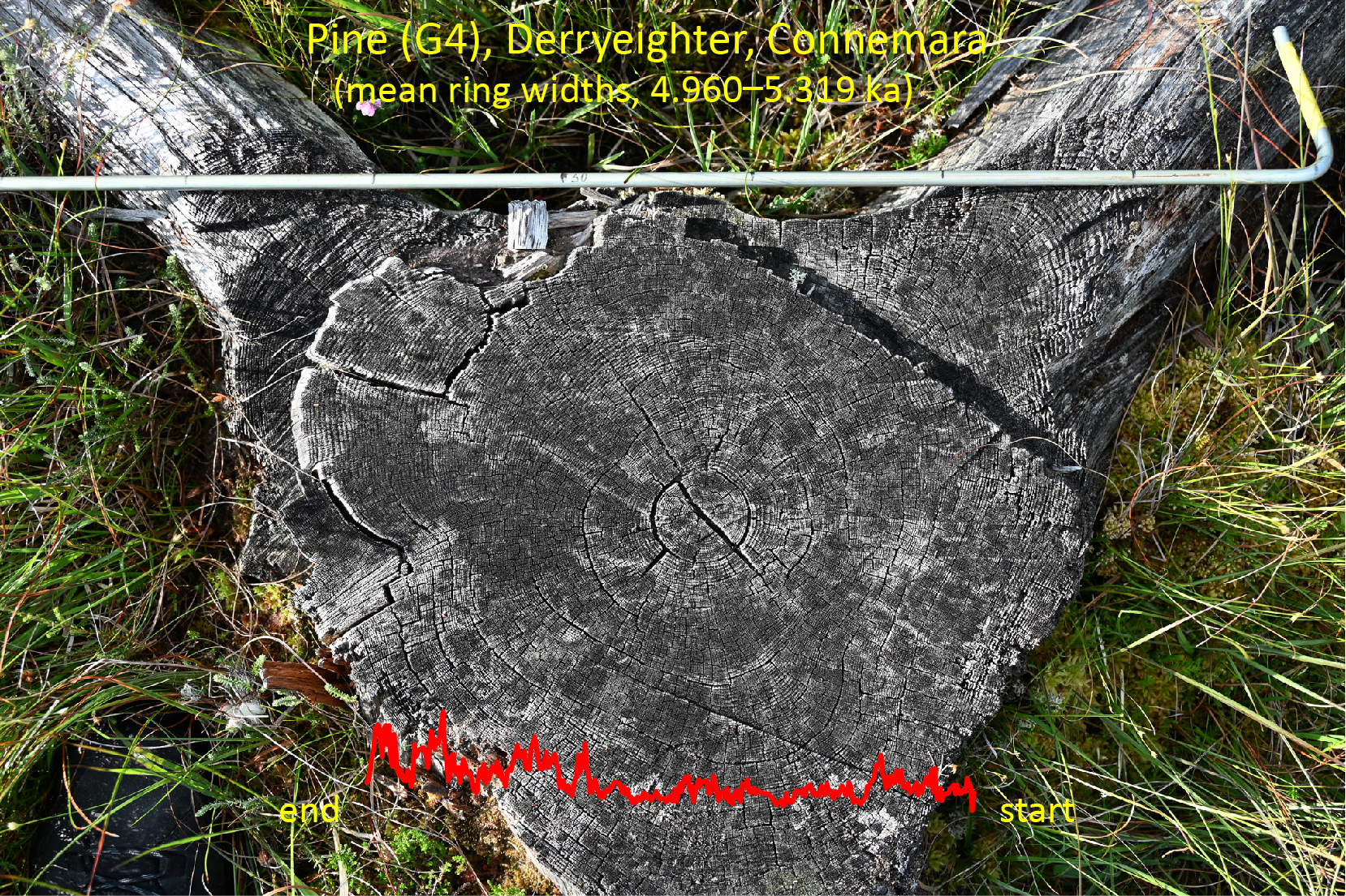
2.3. Derryeighter, Eastern Connemara

Derryeighter (also spelled Derreighter; in Irish, Doire Íochtair, i.e., lower wood [23]) lies at 42 m asl, 13 km south of Ballydoo Bog and 5.6 km west of Oughterard. The study area lies immediately to the south of L. Agraffard (Loch a’ Grafa Árd, i.e., lake of the high grubbed land) in the catchment of the Glengawbeg and Owenriff rivers (Figure 1 and Figure 3; Plate S2). This catchment, which has been designated a special area of conservation (SAC), is ecologically important, as it supports a large population of the freshwater pearl mussel (Margaritifera margaritifera; [29]). The local bedrock is Lakes Marble Formation. To the south, there is a band of gneiss followed by extensive south Connemara granites. To the north, metamorphic and igneous (Oughterard granites) bedrock dominates [2]. In the study area, there is an uneven but generally thin covering of locally derived drift. Blanket bog is extensive. There has been limited reclamation for farming in the low-lying parts and considerable conifer plantations in recent times on higher ground to the south-east (Figure 1B). Extensive peat cutting in the low-lying parts has resulted in the exposure of one of the highest concentrations of bog deal in Connemara. The bog deal consists predominantly of pine timbers and occasional oak timbers. The timbers are mainly stumps, but trunks are also present, including exceptionally long, well-preserved pine trunks (maximum length: 11 m; see Plate S2).
The pine timbers sampled in this study are from low-lying areas to the west of the Glengawbeg river. Most of the timbers sampled (G1–G14, G19, G20) derive from Area 1 (Figure 3C; Plate S2). Here, at least 70 and possibly 100 or more pine timbers (equivalent to approximately 100 and 140 timbers ha−1, respectively) have been exposed as a result of peat cutting that appears to have been carried out by hand several decades prior to sampling in 1993. Peat cutting ceased as the pine–timber layer was reached, and so the timbers are generally in situ. Most timbers rest on peat that is some decimetres thick (~1 m maximum thickness recorded). Elsewhere, large timbers have been revealed, but these are often displaced during relatively recent peat cutting using machinery. Four of these timbers (G15–G18; only G16 in situ), from west of a drainage channel made to facilitate peat extraction (referred to as Area 2 in Figure 3C), were sampled.

3. Materials and Methods

The methods follow standard procedures, as implemented in the Palaeoenvironmental Research Unit (PRU), National University of Ireland Galway (NUIG). Details are provided in earlier publications and in the relevant theses (e.g., [11,30,31]; see Table 1), and are summarised here.
In each area, the main sampling sites were selected after exploratory coring using a 2.5 cm-diameter gouge corer. Monoliths or cores (using a 5 cm-diameter Livingstone corer or a 10 cm-diameter plastic pipe) for detailed investigations were taken depending on the possibilities afforded by the particular site. Subsampling involved taking 1 cm-thick slices of peat/sediment. In some instances, continuous sampling was carried out but generally a 2 to 4 cm sampling interval was used. Sample volume was normally 1 cm3, but 2 cm3 was used in the case of mineral-rich samples and where low pollen concentration was anticipated, e.g., top of core DYR V. The top of the sample, rather than the mid-point, is used when referring to particular samples.
Pollen sample preparation involved (a) addition of a calibrated Lycopodium spore suspension to enable pollen concentration to be estimated, (b) heating in 10% KOH for c. 10 min, sieving, using 100 μm mesh to remove large particles and debris that were normally examined for macrofossils, etc., including macro-charcoal, (c) treatment with cold HF (usually 60%) for ~24 h in the case of mineral-rich samples and heated if samples had a lot of silt/clay, (d) acetolysis for 4 min, and (e) sieving in an ultrasonic bath for 1 min using a fine mesh (in most instances, a 5 μm mesh) sieve to remove any remaining clay particles and small debris. Glycerol was added as mounting and storage medium to the extracted pollen pellet.
Pollen counting was carried out using Leitz and Wild research-quality microscopes. In general, 500 to 2000 grains—excluding bog taxa such as Calluna and Cyperaceae, as well as Sphagnum and non-pollen palynomorphs (NPPs)—were counted per sample. Regularly spaced traverses of whole slides were counted to avoid errors due to non-random distribution of pollen grains. Pollen and spores recorded in subsequent scanning of additional slides were recorded as ‘+’, i.e., a record outside the regular count. Routine identification and counting were carried out at medium magnification (~x500; the magnification varied based on the objective and ocular lens combination), and high magnification (×1000 or higher, using oil immersion) with phase contrast lighting was used to check critical taxa.
Pollen grains were identified using standard keys and descriptions including [32,33,34,35,36,37]. The pollen-reference slide collection in the PRU was consulted in all critical cases. Size criteria for cereal-type pollen followed [32], i.e., pore and annulus width were ≥2.7 μm, but minimum grain size used was 39 μm rather than 37 µm; in most instances, the threshold used was 40 µm. Measurements were made at the time of counting, grain size (longest axis), etc. being measured to the nearest ocular division (=~2.78 μm at medium magnification).
Other critical taxa include: (a) Corylus and Myrica. These morphologically similar grains are regarded as being reliably separable in most instances [38]. When in doubt, grains were assigned to Corylus; (b) Plantago grains were separated with confidence into P. lanceolata, P. maritima, P. coronopus and P. major/media; (c) Ranunculus-type was separated into R. acris-type and R. sceleratus-type according to the criteria in [39]; (d) Vaccinium-type includes all ericoid pollen other than Calluna, Erica tetralix, E. cinerea, Empetrum, etc., which can normally be distinguished from other ericoid pollen with confidence ([32,40]); and (e) filmy fern spores were identified based on spore and tectae size. The spores consisted mainly of Hymenophyllum wilsonii and, occasionally, H. tunbrigense spores. In general, pollen taxon names are as defined in [35,36].
NPPs were identified using [41] and related literature. The practice of using a number preceded by HdV, i.e., the Hugo de Vries laboratory code, is followed in the databases and pollen diagrams. NPP records consist mainly of fungal spores and testae amoebae, i.e., Gelasinospora spores, Amphitrema flavum, Assulina-type, and Tilletia sphagni. Coprophilous fungal spores were not recorded. Charcoal fragments ≥37 μm, i.e., the average size of the added Lycopodium spores, and, in some cores, Erica tetralix epidermis fragments were counted.
The pollen data, originally stored and processed on a mainframe computer, were transferred to Excel using COUNTPOL [42]. Pollen percentages are based on a total terrestrial pollen sum (TTP), i.e., bog/heath taxa, Sphagnum spores, aquatics, NPPs, etc. are excluded. Percentage representation of the excluded taxa are based on the TTP + the sum of the particular category, e.g., bog/heath taxa. Pollen assemblage zones (PAZs) are based on careful visual inspection of the pollen diagrams. A PAZ boundary is always placed at the mineral soil/peat interface where this interface is present in the pollen profile.
For macrofossil identification, the literature consulted included [43,44]. Identification of wood fragments in cores from Ballydoo Bog were carried out using keys and descriptions in [45,46,47]. Estimates of relative abundance were made using the scale: +, rare; 1, occasional; 2, frequent; 3, abundant.
Sampling of cores and monoliths for 14C dating involved taking slices of material, usually 1 cm thick, but sometimes less in the case of monoliths and large diameter cores, and thicker in the case of Livingstone cores. The samples were submitted untreated to the 14C laboratory for conventional dating. In the case of pine timbers, specific rings were subsampled in instances where dendrochronological investigations were carried out. Otherwise, a slice was cut by chainsaw, and well-preserved wood was subsampled usually from outer/younger rings and submitted for 14C dating.
Ash/mineral content, i.e., loss-on-ignition (LOI), was carried out in case of long cores and in some of the short cores by taking 1 cm-thick slices, drying at 90 °C for 24 h, weighing and then ashing at 550 °C for 4–6 h, cooling in a desiccator, and re-weighing.
Age/depth models for the pollen profiles were constructed using Clam ver. 2.3.8 [48] and, in the case of profile CRC I, OxCal ver. 4.4 [49,50]. In both programs, the IntCal20 14C calibration curve was selected [51]. 14C dates that were regarded as reliable were used in constructing the models. In some instances, the age/depth curve was also constrained by pollen-based age indicators such as the secondary rise of Pinus (c. 200 cal. BP).
Details regarding coring locations and the pollen profiles considered in this paper are given in Table 1. Additional details follow as regards the investigations undertaken at Ballydoo Bog, as no information on this site has previously been published. Prior to taking the main core, BDB I, several trial cores were taken from the larger of two banks (~30 sq. m) of what appeared to be non-cutover peat (Figure 1; Plate S1). In several instances, a wood layer (mainly at ~180 cm from the surface) prevented complete penetration.
Table 1. Overview of the main sites and the data (pollen and dendrochronology) presented in this paper.
Site (Name, Location, Altitude, etc.) Publications, Theses, etc. *
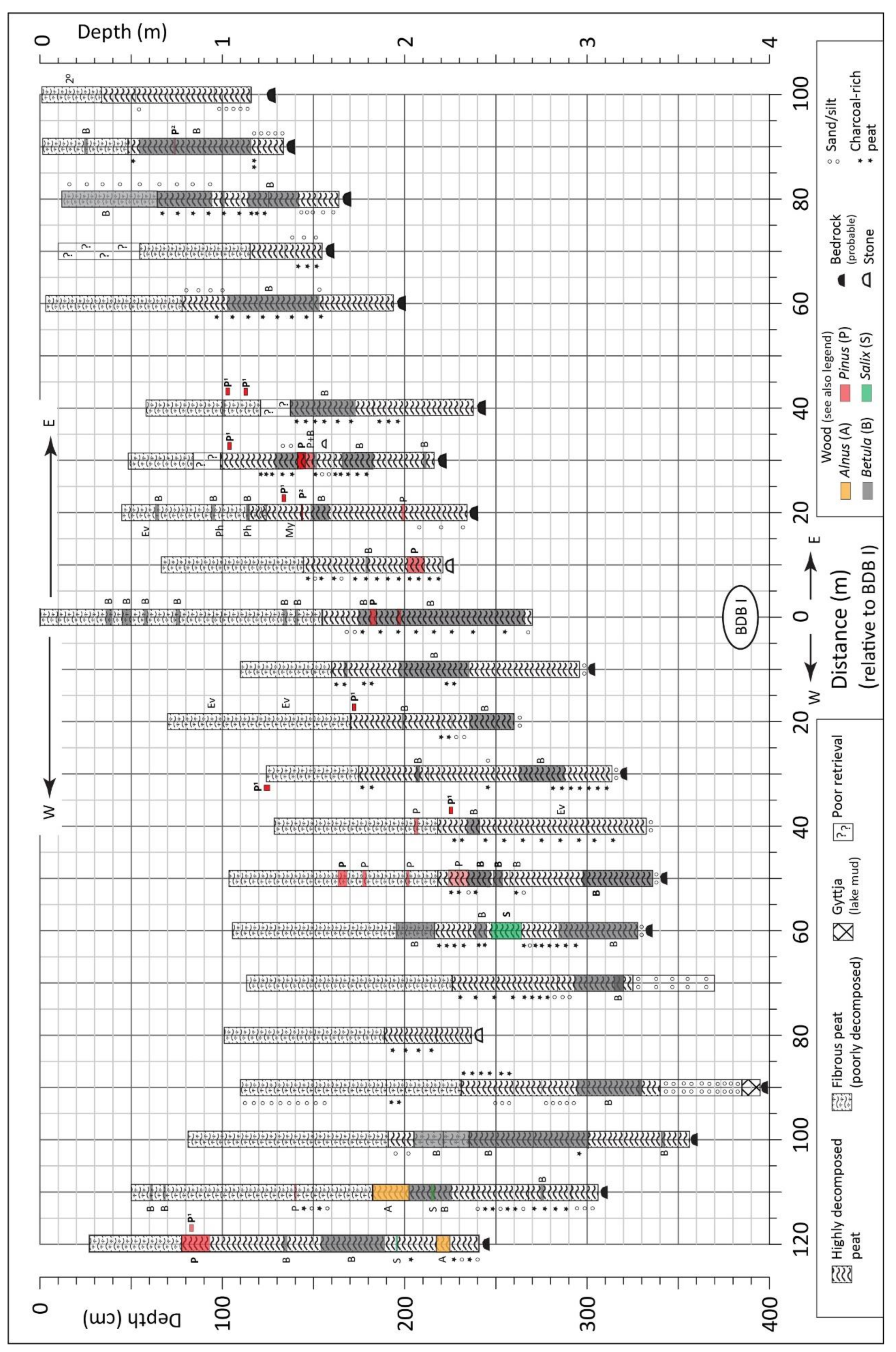
Ballydoo Bog, north of Cornamona, north-east Connemara; basin size: 350 × 150 m; 4.5 ha (pollen)
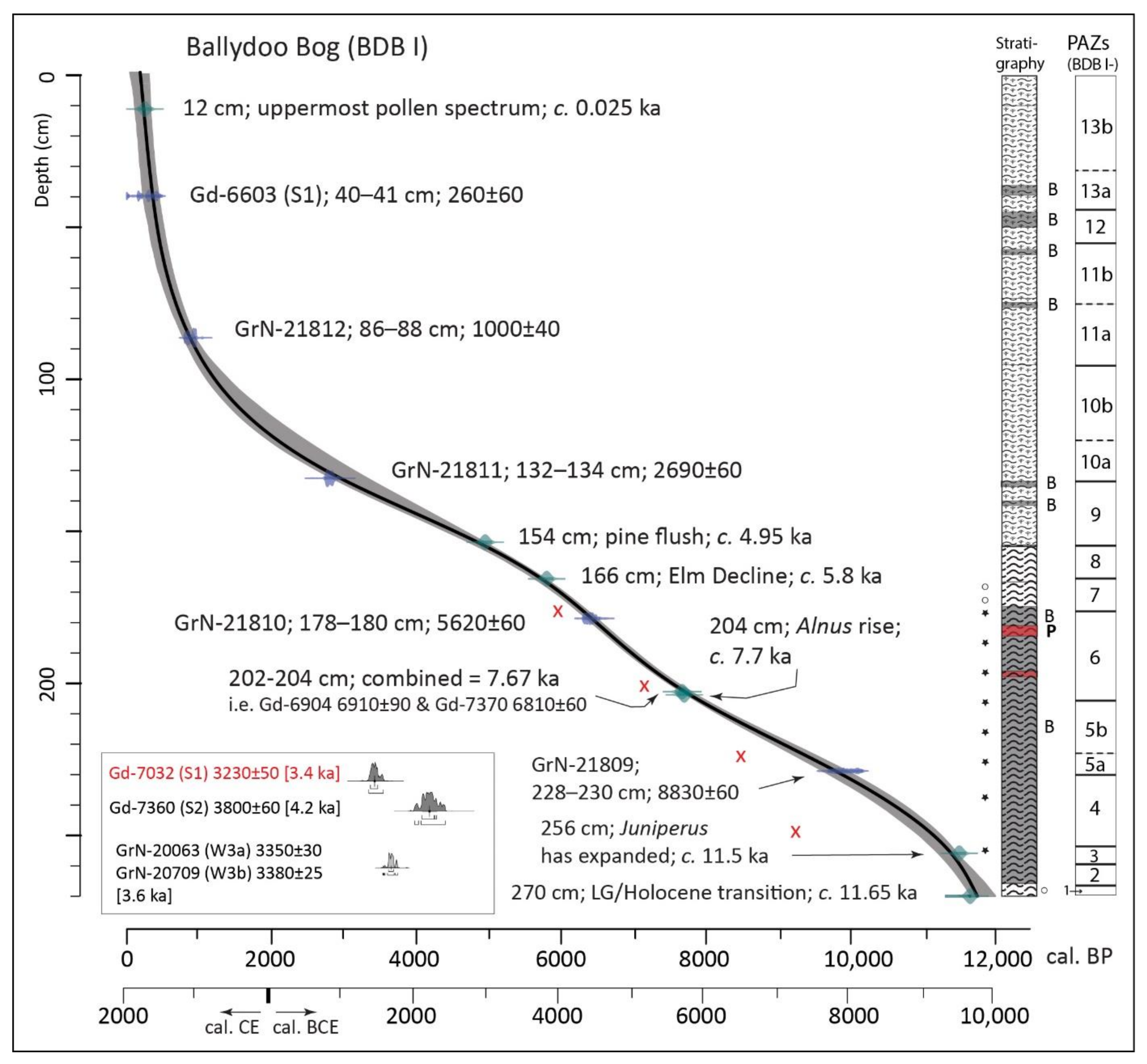
BDB I (peat): ps: 88 + 4 sps; 14C: 12 (4); span: 11.7–0.23 ka
53.53383, −9.46091; 32 m asl; Figure 1C
* [11,30], * [31]; presented in detail
Derryinver hill, Renvyle, north-west Connemara (stone alignment; pre-bog stone walls; henge-like enclosure) (pollen)
DYR I: mineral soil beneath stone wall. ps: 7; 14C: 1; top: 2.43 ka
53.58369, −9.98697; 74 m asl; Figure 2A
* [24]; [10]
DYR II: mineral soil, overlying bk-peat. ps: 14; 14C: 3; span: 2.2–0.11 ka
53.58363, −9.9869; 73.6 m asl; Figure 2A
* [24]; [10]
DYR III: mineral soil beneath stone wall. ps: 6; 14C: 1; top: 1.47 ka
53.5857, −9.9865; 66 m asl; Figure 2A
* [24]; [10]
DYR VI: peat-filled ditch in enclosure; ps: 26; 14C: 2; span: 3.2–0.09 ka
53.58471, −9.98664; 78 m asl; Figure 2A
* [24]; [10]
Derryinver basin bog, Renvyle (extensive blanket bog with pine timbers; cores from marginal location near hill) (pollen)
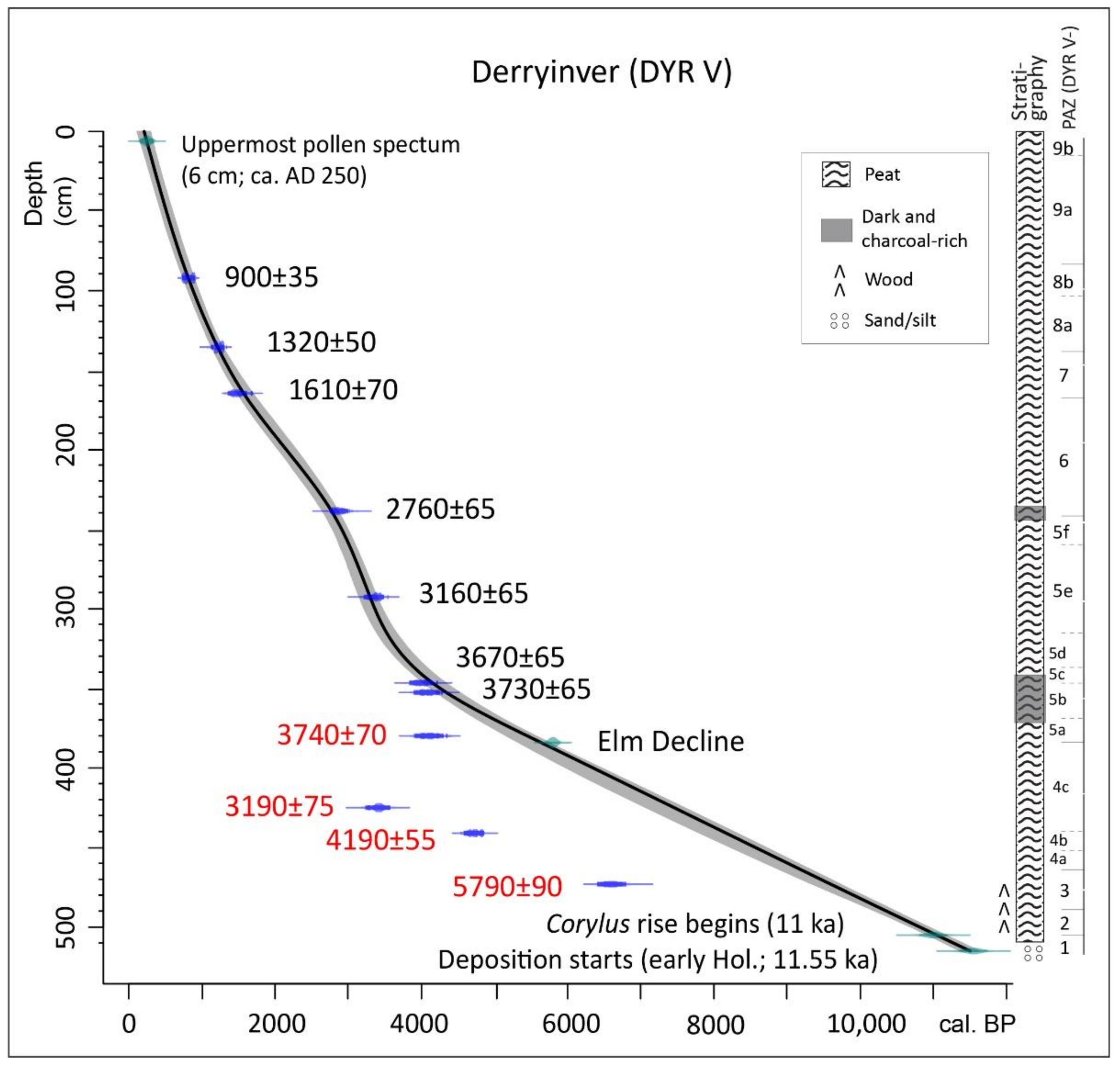
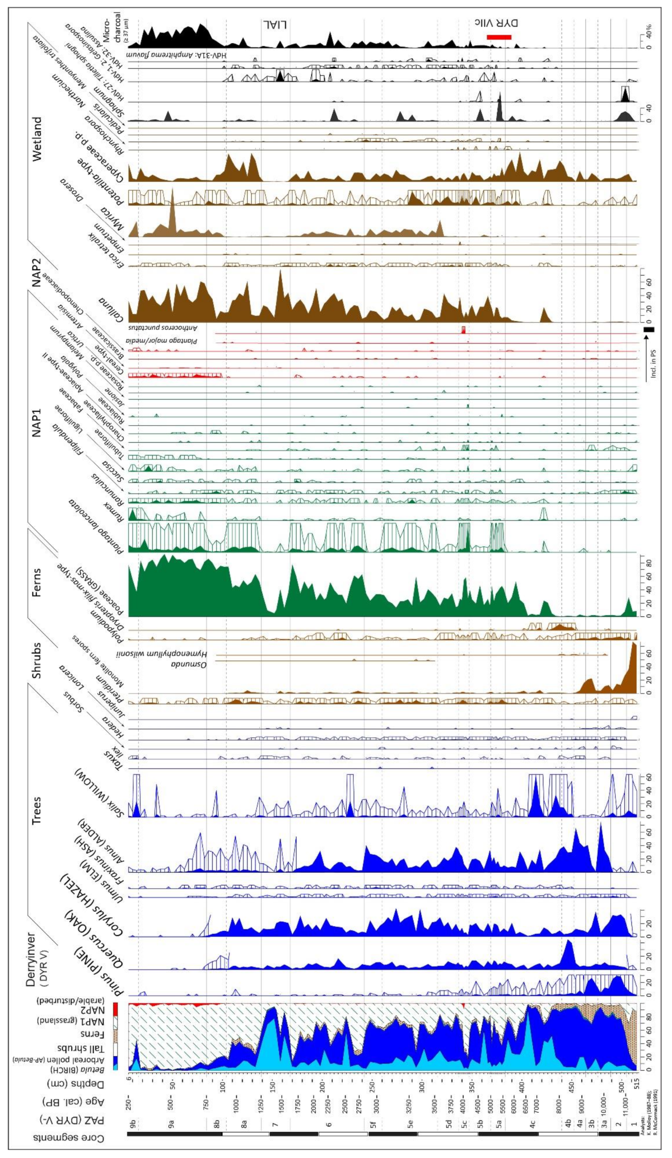
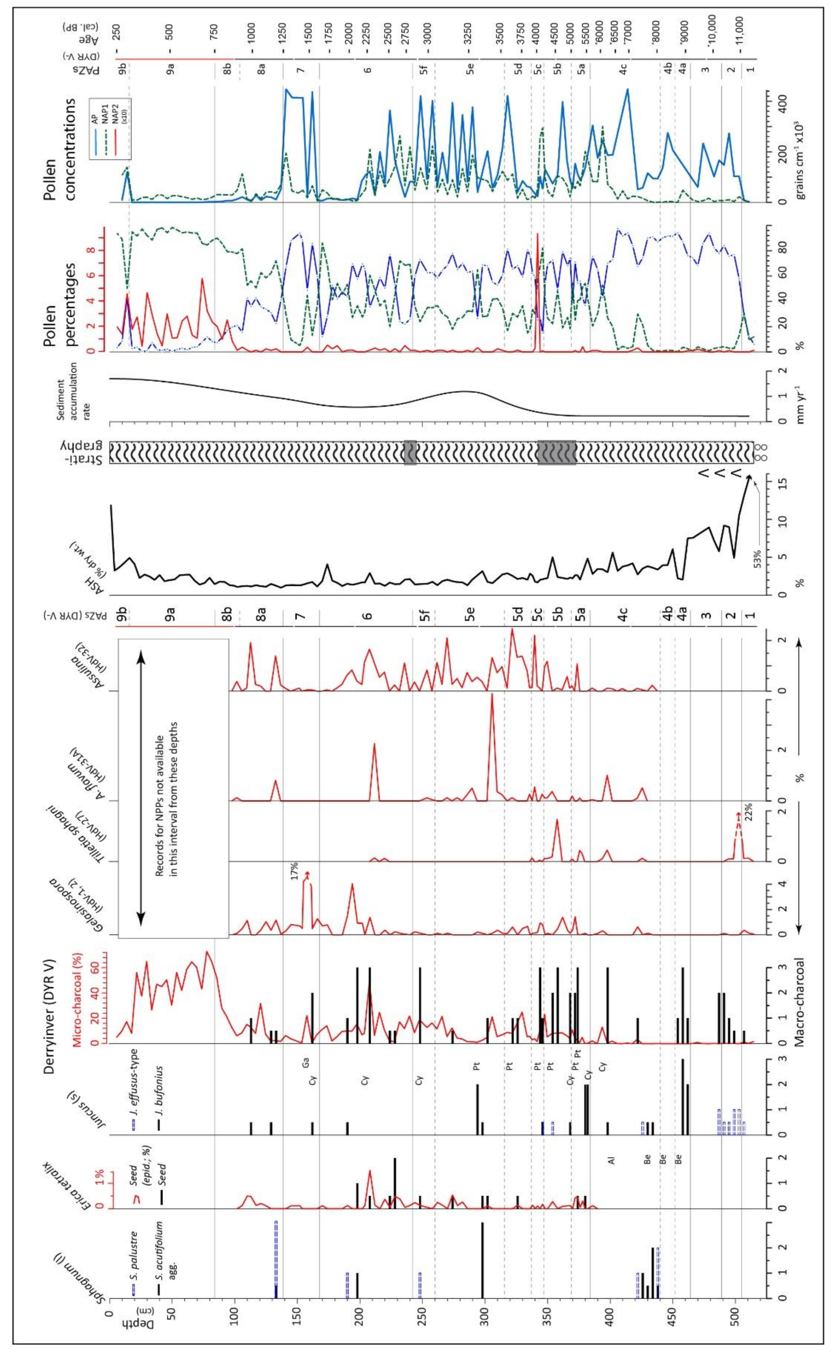
DYR V: peat profile beside hill; ps: 136; 14C: 11 (4); span: 11.5–0.25 ka
53.58407, −9.97903; 30 m asl; Figure 2A
* [24,25]; [9]; presented in detail
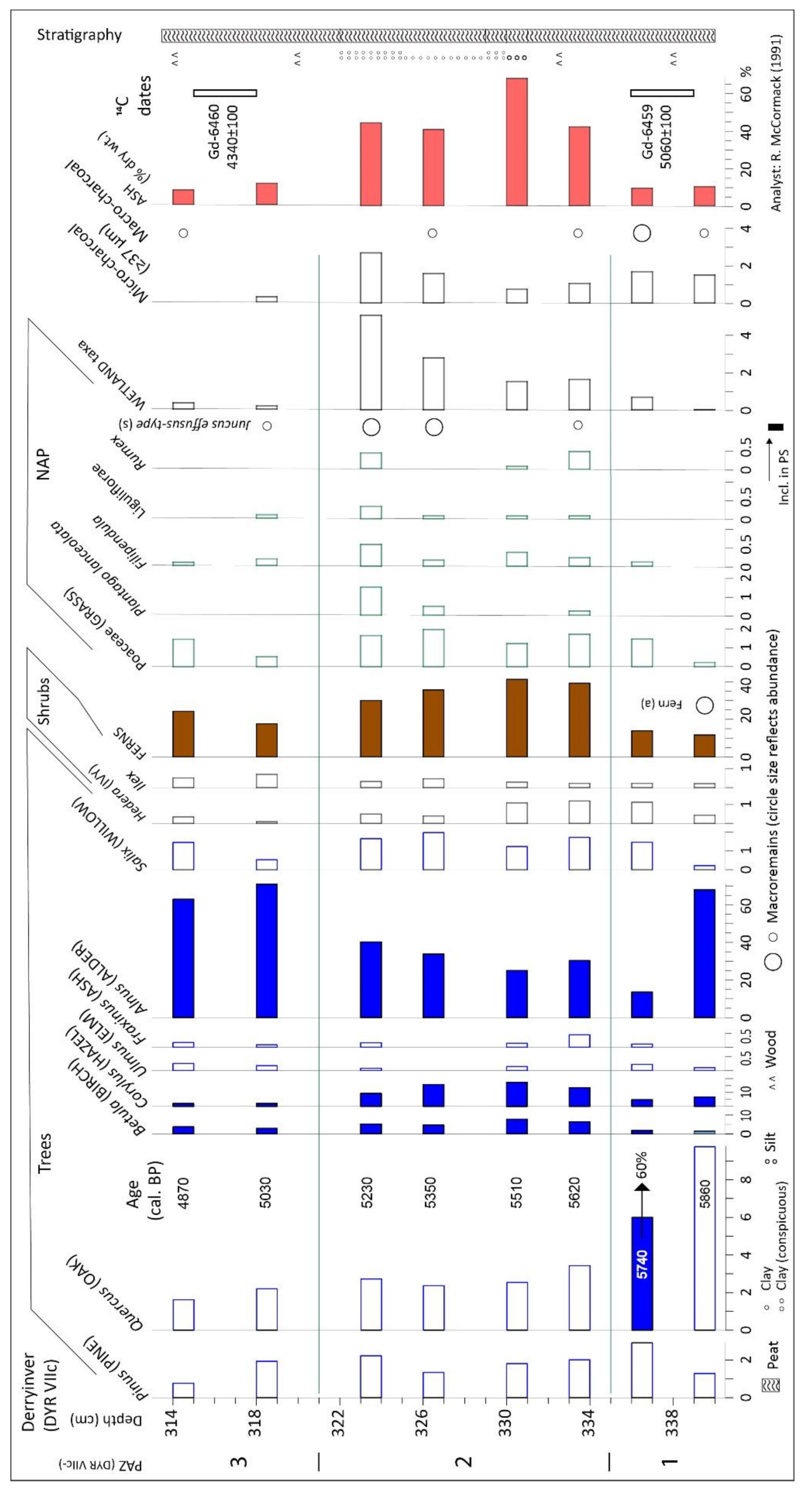
DYR VIIc: 15 m from DYR V, nearer hill; ps: 8; 14C: 2; span: 5.86–4.87 ka
53.58419, −9.97908; 30 m asl; Figure 2A
* [25]; presented in detail
Letterfrack, Connemara National Park, north-west Connemara (pollen and pine dendrochronology)
FRK II: basin peat; ps: 90; 14C: 11; span: 10.3–0.22 ka
53.54375, −9.93593; 97 m asl; Figure 2B
* [26]; [8]
FRK III: blanket peat, mineral soil beneath; ps: 8; 14C: 2; span: 3.7–2.35 ka
53.54477, −9.9395; 91 m asl; Figure 2B
[27]
FRK IV: blanket peat, mineral soil beneath; ps: 32; 14C: 4; span: 4.36–0.1 ka
53.54556, −9.94644; 70 m asl; Figure 2B
[27] (in part)
Dendrochronology: pines from CNP, Letterfrack, and from Carrowkennedy (Co. Mayo) and Corboley (Barna, S.E. Connemara) (at VC, CNP); Figure 1A,B and Figure 2B* [11]; presented in detail
Crocknaraw (hilltop site) and Claddaghduff, north-west Connemara (stone walls at bog edge) (pollen)
CNR I: blanket peat, underlying mineral soil; ps: 10; 14C: 3; span: 6.3–3.26 ka
53.53502, −10.02508; 105 m asl; Figure 1B
* [11]
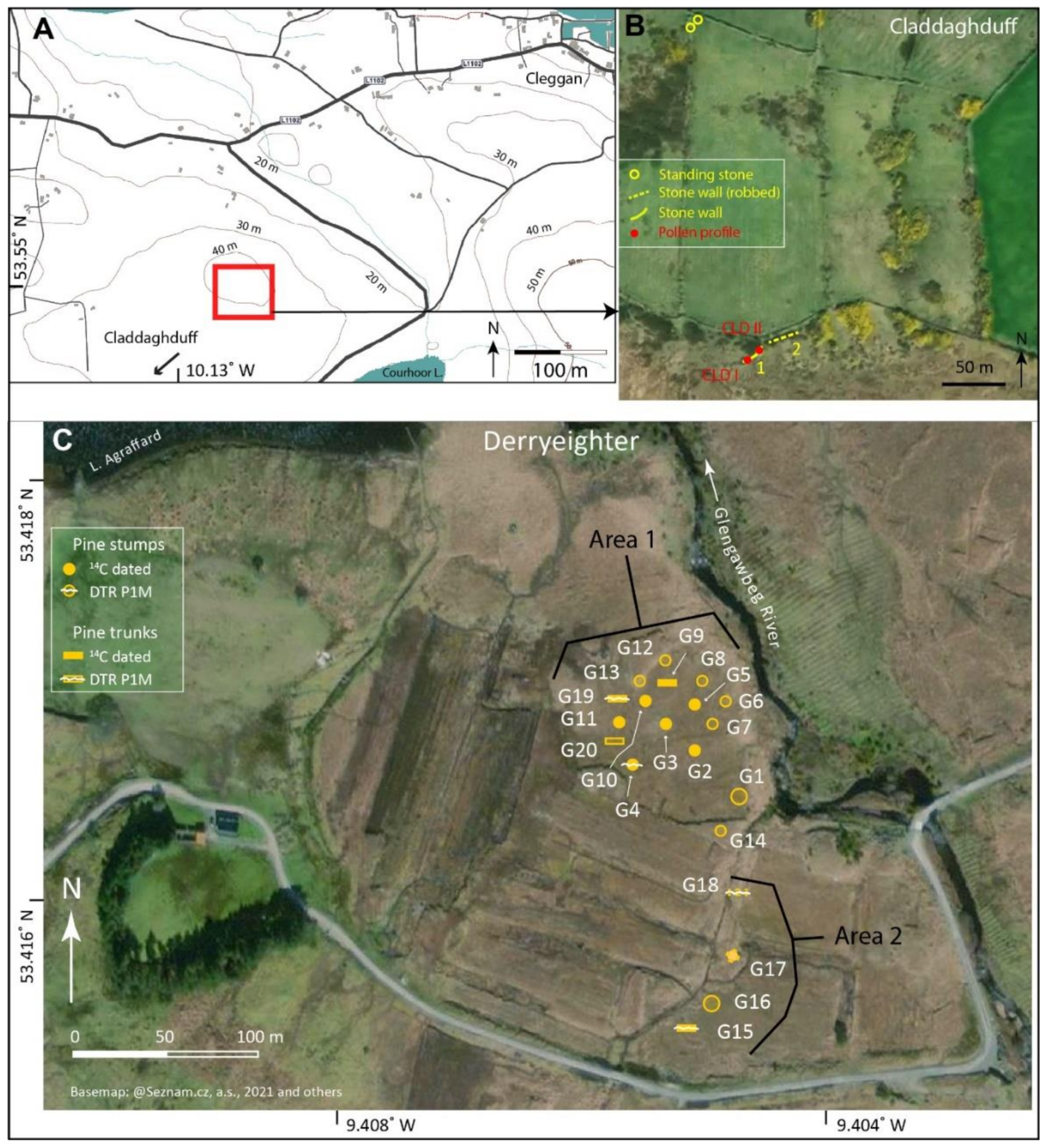
CLD I: blanket peat and underlying mineral soil, beneath stone wall; ps: 17; 14C: 2; span: 4.9–2.9 ka
53.54895, −10.12698; 38 m asl; Figure 3A,B
* [24]
Derryeighter, eastern Connemara (14C dating and pine dendrochronology;Figure 3C)
Derryeighter, Area 1 (centred on 53.4166853, −9.4052939; 42 m asl)
Derryeighter, Area 2 (centred on 53.4153475, −9.4050792; 42 m asl)
* [11]; presented in detail
Conventions and abbreviations: ps = no. of pollen spectra; no. of 14C dates are indicated, no. of rejected dates is given in parentheses; top = age of top of profile, based on median cal. date derived from a 14C date; span, i.e., duration, is based on the age/depth model; sps = surface pollen spectra. * Theses (unpublished) are indicated by an asterisk. ‘Presented in detail’ indicates that data are discussed in detail in the main text. All primary data are/will be available in PANGAEA and various plots, photographs (labelled Plates), etc. are included as supplementary material.
Core BDB I was retrieved in three parts as follows in September 1991. A pit was dug, from which two monoliths were removed, i.e., monolith BDB IA (0–45 cm) and BDB IB (45–95 cm). The lower part of the deposit (95–270 cm; BDB IC) was recovered using a 10 cm diameter sewage pipe. The combined sample is referred to as BDB I.
The stratigraphy of the basin was investigated along transects that ran approximately east–west through the coring point BDB I (Figure 1), with a view to establishing the overall stratigraphy and ascertaining the extent and depth of the woody layer that was recorded in both early trial cores and the main core, BDB I. Corings were made using a gouge corer, mainly at 10 m intervals along the transects. Levelling was carried out by theodolite so as to enable plotting of core stratigraphies relative to core BDB I. Coring points are referred to as metres relative to BDB I; W and E are added to indicate locations west and east of BDB I, respectively. At several locations, wood prevented complete penetration. Such obstacles were avoided by moving laterally up to 2 m. Where wood remains were recovered, these were identified where possible in the field. Where there was doubt as to identification, samples were retained, sectioned in the laboratory, and examined microscopically. In some instances, the wood fragments were too small or poorly preserved to differentiate between Alnus and Betula. In these instances, the wood was not identified to genus.
Dendrochronological investigations were carried out on pine timbers from Derryeighter and on pine timbers associated with CNP. Standard dendrochronological methods, as described in [11], were employed. Sampling in the field involved cutting at least one slice of timber from as high up the stem as possible in the case of a stump, and from an area clear of side branches and close to the stump where tree trunks were available (additional details are given below for particular sites).
Ring widths were normally measured along several radii using a Wild M8 binocular microscope and a moving stage, to which was fitted a linear encoder (Heidenhain LS406C) linked to a digital counter (Heidenhain Bidirectional counter VRZ 405) that inputted ring-width measurements to a PC. Upon being satisfied that the measurements were satisfactory (no missing rings, etc.), mean ring widths for the particular timber were calculated. Cross-dating was attempted visually by matching the graphed plots of the ring-width measurements and statistically, using the cross-dating programs CROS [52] and CROS84 [53]. The most reliable matches, i.e., those that yielded the highest t-values at long overlaps, were used to build up groups of trees with overlapping ring series. A significant match was where t was ≥3.5 (p = 0.01). Groups of trees that showed satisfactory cross-dating (both visually and with self-consistent, significant t-values, i.e., above 3.5) were combined into working chronologies. Before a working master chronology was produced, individual series were standardised [54] so as to remove long-term trends in the data such as those related to the age of a tree.

4. Results

Summary statistics regarding the various pollen profiles (number of spectra and 14C dates and time-span represented) are given in Table 1. Detailed results from the various sites are described below. Pollen, 14C and dendrochronological data are plotted in Figure 4, Figure 5, Figure 6, Figure 7, Figure 8, Figure 9, Figure 10, Figure 11, Figure 12, Figure 13, Figure 14 and Figure 15, and further details are available in Figures S1–S6 and Tables S1–S8.

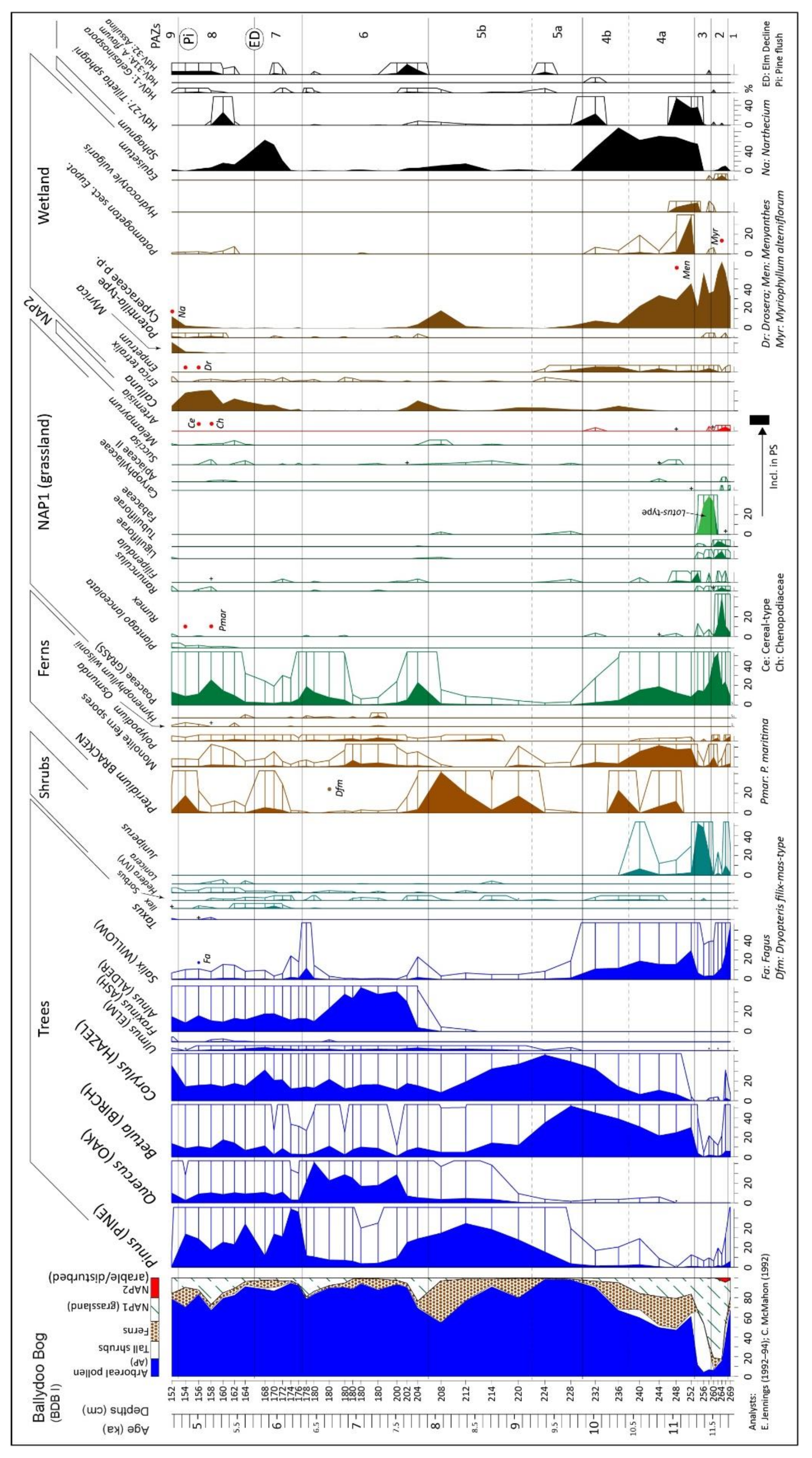
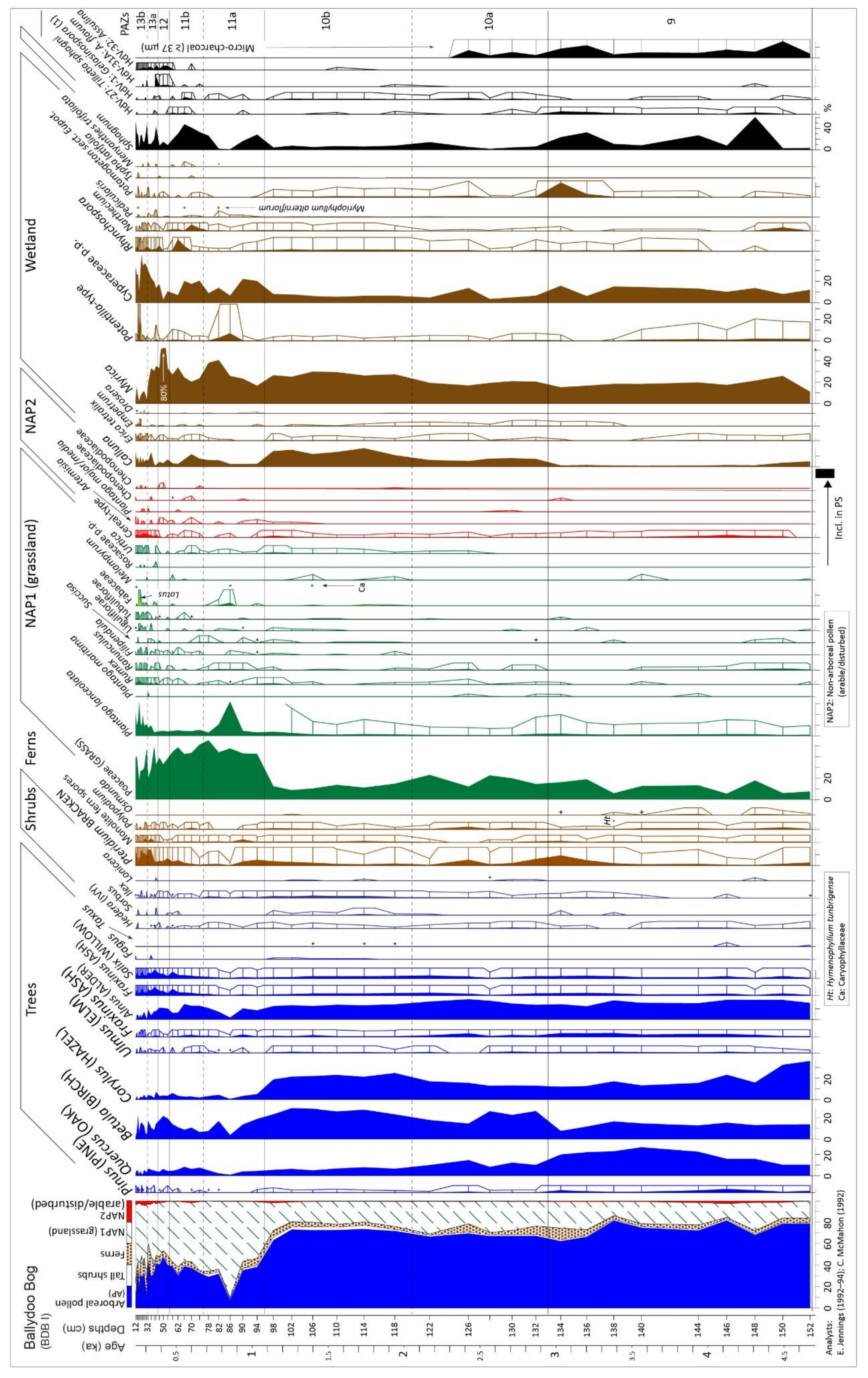
4.1. Ballydoo Bog, Cornamona

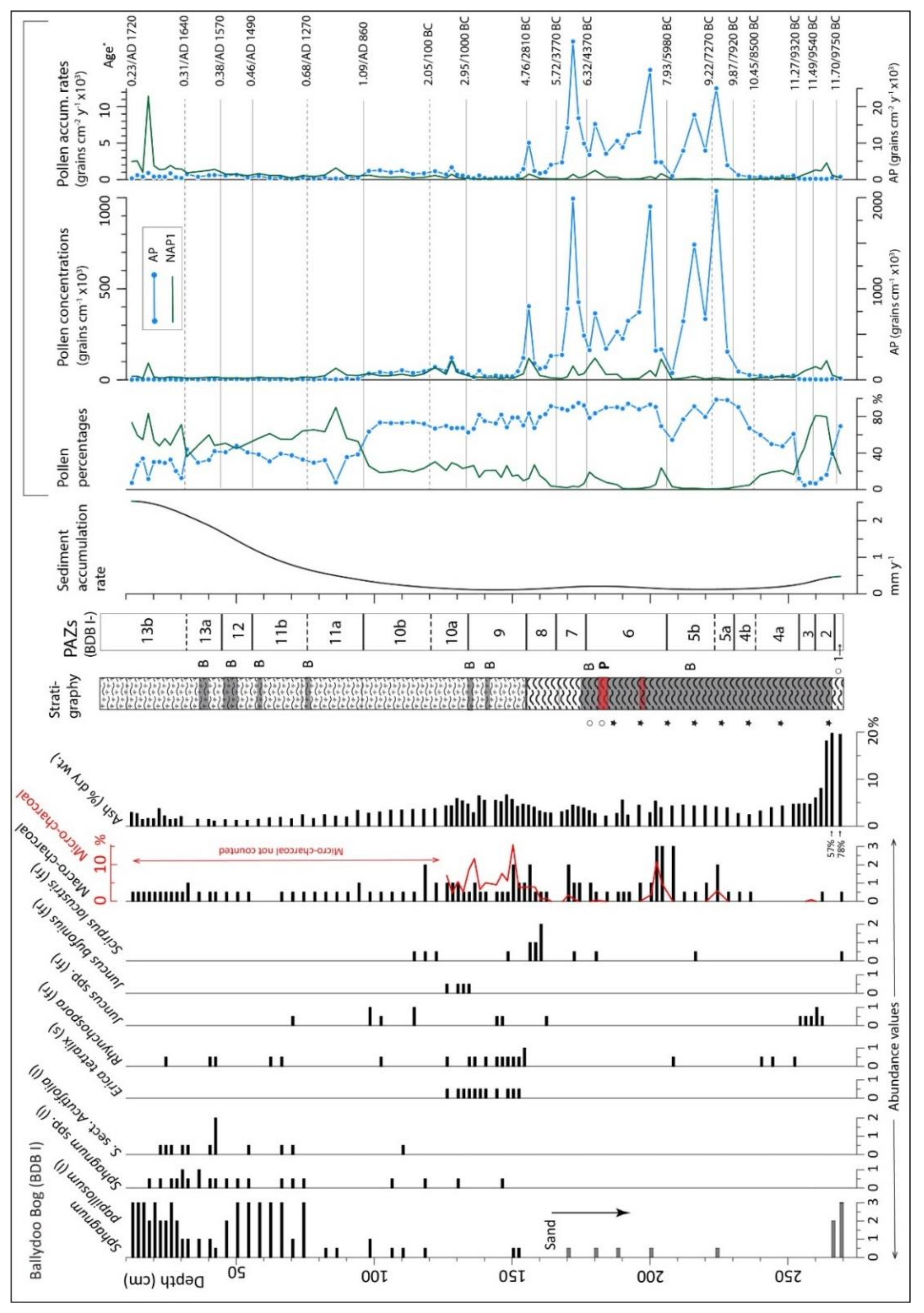
4.1.1. Peat Stratigraphy (in Basin and Core BDB I)

Figure 4 shows the stratigraphy along the transect, including at the main coring site BDB I. Further details are available in Table S7. The basin floor generally slopes from east to west. The present-day drainage, consisting of a small stream on the southern margin, also flows in this direction before turning south to Ballydoo L. (Plate S1). It is only in the deeper western part of the basin that sandy deposits were recorded beneath the peat (70W and 90W). At 90W, in the basal sediments, fine gyttja resembling Allerød deposits, similar to those known from other sites in Connemara, was recorded. If the gyttja relates to the Allerød, then the overlying grey sand was probably deposited during the Younger Dryas (11.65–12.85 ka; [56]).
At most locations, substantial woody remains were recorded in the lower, well-decomposed peat. This was mostly Betula (cf. B. pubescens), but wood of Alnus and Salix was also recorded (substantial Salix at 60W between 248–264 cm; Alnus was recorded at close to the same level at 110W and 120W, respectively). In several instances (20W, 40W, 50W, and 120W; and 20E, 30E, and 40E), large timbers necessitated relocating the coring position so as to avoid these obstacles. The timbers involved were probably mostly pine (but see below). Pine cones were recorded at 20E and 90E. Pine stumps by and large are not exposed, except in a limited area towards the north and north-west of the basin, and along deep drainage trenches to the west of BDB I and at 30W. Since the timbers are largely hidden, identification was often impossible, except in instances where bark or identifiable wood fragments were retrieved (cf. 50W, 10E, 20E, 30E, and 40E). Substantial wood of other trees, including Betula, which is common, also increased the difficulties associated with the exploratory corings (at 50W, for instance, substantial Betula wood was present).
Corings in the small bank of peat where BDB I was taken confirmed the local presence of a well-defined layer of pine stumps at ~180 cm. Charcoal-rich peat was recorded both above and below this layer, the lower charcoal layer being particularly pronounced and containing sand. At ~50 m south-east of BDB I, where the peat had been cutover, charcoal-enriched peat with sand and silt was recorded at 175–177 cm below the surface of the cutover peat (no levelling data available for this point). Based on the available stratigraphical evidence, many of the pine stumps encountered may be more or less contemporaneous. However, some timbers occur at distinctly higher levels in the peat; e.g., the pine stump exposed in the cutover peat, 3 m east of coring point 30W (this stump, referred to as BDB W3, was 14C dated; Figure 5; also below).
Charcoal and minerogenic-rich layers are common at approximately mid-depths in much of the peat body. The latter varied from grey/white minerogenic layers of ~1–10 mm thickness (cf. 20W, 40W, 50W, 60W, and 10E) to thick silty peat layers (~10–20 cm thick; Figure 4). A small stone was recovered at 152–161 cm depth at 30E. The charcoal layers varied from dark, charcoal-rich peat to obvious bands of conspicuous black charcoal, ~1–15 cm thick. At 20E, burnt twigs within a dark charcoal layer (recorded at 139–149 cm) suggests fire on the bog surface that probably relates to the mid- or early Holocene (cf. peak in charcoal at 202 cm in BDB I). For the most part, these minerogenic and charcoal-rich layers coincide with pine and other wood layers (cf. 10E, 30E, and 40W).
In the upper part of the deposit (above ~130 cm), the peat is less decomposed, lighter in colour, more fibrous, and Sphagnum-rich. It presumably derives from blanket bog-type vegetation. Wood is infrequent, but it is noteworthy that pine stumps have been noted in the upper levels, i.e., near 30W (at ~120 cm relative to the top of BDB I; see above), and a layer of pine wood was also recorded at 80–93 cm (again relative to the top of BDB I) in core 120W. Sand has also been recorded in the upper peat, e.g., at 90W, 110–160 cm.
The record of Myrica wood at 20E is of particular interest, in that it confirms the local presence of M. gale (for pollen evidence see below). Though not dated, its position in the peat body at ~137–138 cm depth relative to the top of BDB I suggests that this wood is mid- to late Holocene in age and appears to be later than the main pine decline.
As regards core BDB I, stratigraphic features include silty peat at the base (270–267 cm), and dark, highly decomposed peat between 267–155 cm (Figure 4, Figure 5 and Figure 8). Most of this peat is charcoal-enriched. There is a particularly pronounced pine timber layer at ~183 cm, and here and immediately above silt was conspicuous (but there is only a modest increase in ash content). A distinct change towards less decomposed peat is initiated at 155 cm, and this is maintained to the top of the core. In this upper, poorly decomposed peat, Betula wood is occasionally present, and especially between 50 and 37 cm. Ash content is at its lowest between ~100 cm and 30 cm (Figure 8), which suggests that mineral input (atmospheric and groundwater) too was low, i.e., between c. 1.2–0.3 ka (750–1650 CE).

4.1.2. Radiocarbon Dating (Ballydoo)

Results of 14C dating of peat samples from profile BDB I and pine timbers from Ballydoo Bog are presented in Figure 5, and details are available in Tables S1 and S4. Comparison of the Gd (Gliwice) series 1 and 2 (S1 and S2; S2 samples were submitted after S1) and, in particular, the results from dating wood from the same block of timber (BDB W1 and W2, i.e., Gd S1 and S2 series, respectively) indicate a young bias (in the order of several centuries) in the S1 dates (Figure 5). The difference between expected and 14C-based age appears, however, to decrease in the younger samples (see points marked ‘x’ in Figure 5). There is no obvious bias in the uppermost date from the peat sample of the S1 series, and so this is used in constructing the age/depth model.
In addition to the 14C dates, the following indicators of age were used for constructing the age/depth model for BDB I: Lateglacial/Holocene transition (11.65 ka; [57]); Juniperus in the early Holocene has expanded (11.5 ka); early Holocene Alnus rise (7.7 ka); elm decline (5.8 ka); and pine flush (4.95 ka) (see [58,59,60]), and an estimated age for the top of the pollen profile, i.e., c. 1700 CE (12 cm depth; secondary rise of Pinus—indicative of afforestation; it has not registered in the profile). The age/depth curve, i.e., a smooth spline curve (smoothing factor = 0.3) generated by Clam, was regarded as giving the best age/depth relationship and is used to assign ages to the profile. A notable feature is the increased peat accumulation to >2 mm y−1 in the top metre from ~0.2 mm y−1 in the lower part of profile. The increase coincides with the rise to dominance of Sphagnum papillosum (see below).

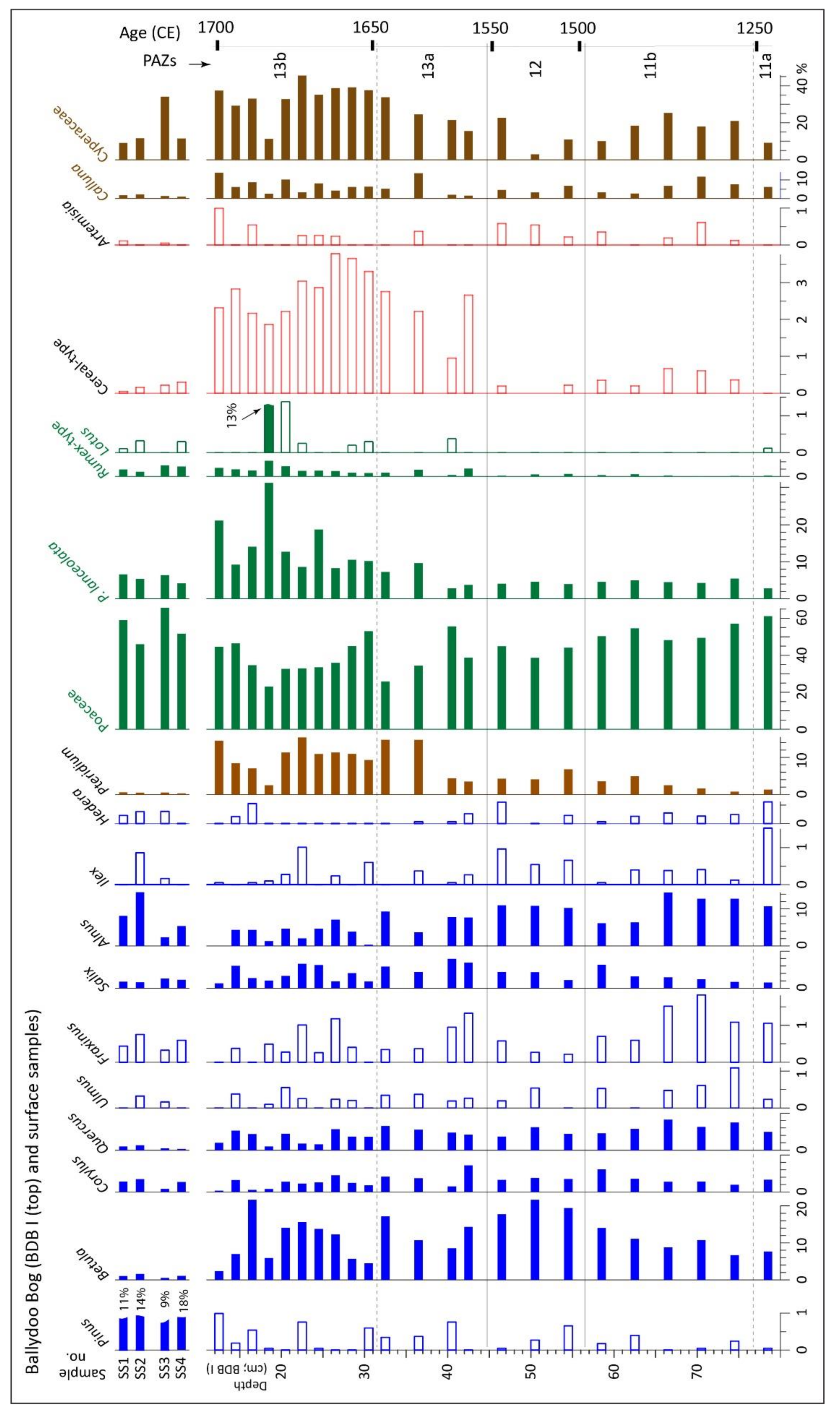
4.1.3. Pollen and Related Data, Core BDB I

The lower and upper parts of profile BDB I (269–152 cm; 152–12 cm) are presented separately (Figure 6 and Figure 7). These are plotted to an age scale. In Figure 8, plant macro-remains, macro- and micro-charcoal (the former ≥100 µm from pollen sievings, the latter ≥37 µm; counted during pollen analysis), sediment accumulation rates and summary pollen data are plotted to a depth scale. In Figure 9, the main percentage curves for the uppermost pollen spectra (78 cm to top) and data from surface pollen samples are shown [12].
A description of the pollen assemblage zones (PAZs) and an interpretation in terms of vegetation development and general environmental change are provided in Table S8. The salient points are as follows. The basin is small (present extent: 350 × 150 m; 4.5 ha) and enclosed and surrounded by relatively fertile land (Figure 1) within a relatively large basin, with Ballydoo L. at its centre (Plate S1). Surrounded on three sides by high ground, the large basin opens to the south towards Cornamona (Corr na Móna) and L. Corrib, and so is relatively sheltered from the prevailing south-westerlies. Given its geographical situation, the small extent of the mire, and predominantly south-westerly winds, it is assumed that pollen profile BDB I reflects mainly vegetation development on the mire and its immediate environs, i.e., the low-lying ground, and partly the uplands, especially those to the west. An effective pollen source area of 500–1000 m radius centred on the coring location is regarded as apposite. In the early Holocene, the mire was undoubtedly less extensive, so the pollen source area was probably smaller and more local in character, especially prior to the opening-up of the woodland from the Neolithic onwards [61].
At the coring site, organic accumulation began in the early Holocene (Figure 6 and Figure 8). Initially, sediment accumulation seems to have been rather rapid. Pollen assemblage zones 1–3 document the early succession of willow including probably arctic willows, dock (Rumex and Oxyria species) and Asteraceae (Liguliflorae and Tubuliflorae), then grasses and Fabaceae-rich (especially Lotus) herbaceous vegetation, and finally juniper scrub. Birch (presumably tree birch; most likely B. pubescens) expands, quickly followed by hazel. Hazel appears to out-compete birch but, in turn, is out-competed by pine (Pinus sylvestris). Noteworthy is the open character of the pine woods, indicated by high Pteridium values. Alder arrives and expands relatively rapidly (by 7.65 ka). Interestingly, oak achieves dominance by 7.5 ka. Bog-oak timbers were not recorded, so it is assumed that the Quercus pollen derives from oak growing on mineral soils (PAZ 6).
Centred on c. 6.2 ka, there is a relatively short phase during which Pinus achieved maximum values (60%) (Figure 6; base of PAZ 7). The main concentration of pine timbers occurs at ~180 cm, i.e., towards the top of PAZ 6. These timbers probably derive from the trees that gave the elevated Pinus pollen values in zones 7 and 8 (Figure 6).
The PAZs 7/8 boundary is regarded as the position of the elm decline and transition from Mesolithic to Neolithic, though neither a distinct decline in Ulmus nor a Neolithic landnam-type event is recorded. Given the low overall representation of Ulmus (Figure 6; Table S8), failure to record a distinct elm decline is not too surprising. The absence of evidence for a Neolithic landnam is somewhat surprising, especially given that early Neolithic impact is strongly expressed in many Irish pollen records. Landnam may have gone unrecorded in the present instance (~140 y between samples in this part of the profile; each sample integrates ~70 y of pollen deposition) but this seems unlikely given that Landnam events in Ireland are invariably of much longer duration than a century and often result in high P. lanceolata values (can be up to 10% TTP [59,62]; see also profile DYR V below). It is concluded that there was no major early Neolithic farming impact at Ballydoo, which fits in with the lack of archaeological evidence for a local Neolithic presence. In PAZ 8, a continuous P. lanceolata curve is initiated (5.5 ka), a development that is regarded as reflecting Neolithic farming at a wide regional scale.
Elevated Pinus values at the end of PAZ 8 probably reflect the regional establishment of pine woodland on bog, i.e., the pine flush that was widespread in western Ireland at c. 5 ka ([59,60]). There are no local pine timber records that can be assigned with certainty to this time but given that pine timbers are frequent in the basin and persisted until at least 3.6 ka (14C dates from pine timbers in Figure 5, inset), it is reasonable to assume that bog-pine was locally present at this time.
The upper part of the profile (PAZs 9–13; Figure 7, Figure 8 and Figure 9) reflects developments in the later Holocene (Neolithic/Bronze Age transition to early eighteenth century), while surface pollen samples provide information on recent (mainly 1980s/beginning of 90s) pollen deposition. Zones 8/9 transition at 4.76 ka coincides with a distinct change from highly decomposed to poorly decomposed peat that reflects a wetter bog surface (cf. Rhynchospora (fr) and E. tetralix (s) records in Figure 8; also Myrica, Potamogeton, Sphagnum, etc. in Figure 7). If this signals a climatic shift (increased precipitation and/or lower temperatures), as appears to be the case, then the increased farming impact that is associated with the late Neolithic and especially the Bronze Age (also very much in evidence here; cf. P. lanceolata and cereal-type curves) takes place in the context of an unfavourable climate at least relative to that pertaining earlier ([55,63,64,65]). A climate shift towards more oceanic conditions would have been unfavourable to pine, especially as a coloniser of bog surfaces [66]. There is, however, secure 14C evidence that pine persisted locally on the bog until at least 3.6 ka (Table S4; Figure 5, inset).
Another substantial shift in vegetation and land-use takes place at the beginning of subzone 10a (c. 3 ka, i.e., late Bronze Age; Figure 7). Quercus and Fraxinus decline, which suggests clearance of woodlands that are now dominated by oak. Non-arboreal pollen (NAP) indicators of clearances and farming do not expand substantially, but there is a considerable amount of birch, at least some of which is growing on the mire (cf. pollen and wood records) and which, undoubtedly, had a filtering effect on pollen input at the coring location [67]. In subzone 10b (c. 2–1.1 ka), there is an increase in shrubby vegetation (especially birch and hazel), but indicators of human impact increase as the zone ends (from c. 1.3 ka; 650 CE). This upsurge is probably part of the general increase in farming (initially pastoral; later arable; cf. [68]) associated with the early Medieval period and the spread of Christianity in Ireland.
The most pronounced change of the mid-/later Holocene occurred during the mid-/late Medieval period. This involved widespread woodland clearances that directly led to the open present-day landscape in which woody vegetation (both tall canopy trees and shrubs such as birch and hazel) is no longer important. The age/depth model suggests that the opening-up was initiated at c. 1.1 ka (850 CE), but it should be borne in mind that the chronological control in the uppermost part of the profile is rather weak (Figure 5). Additionally, striking is the contrast between modern pollen deposition and that of a few centuries ago (top of the profile; Figure 9). In the surface pollen spectra, Pinus is once again an important contributor (reflecting afforestation), all other arboreal pollen (AP) taxa apart from Alnus are much reduced, and NAP and especially key farming indicators such as P. lanceolata and cereal-type pollen are also lower. The high values for cereal-type pollen in PAZ 13 (average 2.8 ± 0.21% in subzone 13b) suggest substantial cereal cultivation. High P. lanceolata values (14.5 ± 2.32%) probably arise in large measure from disturbed habitats ([69]), including those associated with potato cultivation, which goes unrecorded due to severe under-representation of Solanum tuberosum in pollen records ([70,71]).

4.2. Derryinver, Renvyle

In Connemara, Derryinver has the highest concentration of pollen sites and the most detailed analyses. Investigations on Derryinver hill (locally called The Tulach, i.e., The Mound) have already been published [10] so the focus here is on the investigations carried out at the base of the hill in the margins of an extensive bog (Figure 2, Figure 10, Figure 11, Figure 12, Figure 13 and Figure S1; Table 1 and Tables S2; Plates S1 and S3; also Introduction). The main profile, DYR V, which spans most of the Holocene, is considered first.
An age–depth plot, stratigraphy, and other details relating to profile DYR V are shown in Figure 10. Four 14C dates from the lower part of the profile were rejected for being much too young (Figure 10), so the chronology in this part is poorly constrained. Overall, sediment accumulation rate is high. In the lower part of the profile, it averages 0.22 mm y−1; in mid-profile (in a part of core between two charcoal-rich layers) it increases substantially to achieve a maximum of 1.2 mm y−1 (350–250 cm; 4.3–2.9 ka), and begins a steady increase again above 145 cm (1.3 ka; 650 CE) to achieve 1.7 mm y−1 at the top of the profile (Figure 10).
Profile DYR V is from within ~30 m of mineral soils of the adjoining hill and so is decidedly marginal with respect to the extensive bog that lies to the east (Figure 2A; Plate S3). Accordingly, the pollen input is expected to strongly reflect local developments in the marginal parts of the bog (especially hygrophilous trees and shrubs such as Salix, Alnus and Betula), and vegetation and land-use changes on the mineral soils of the adjoining hillside. The rapid changes in several of the pollen curves support this conclusion (Figure 11).
The profile opens in the early Holocene prior to the spread of tall trees. Typical features such as the early Holocene expansion of Juniperus and, subsequently, Betula find only weak expression (zone DYR V-1), presumably due to slow peat accumulation and poor preservation (cf. high fern spore representation, due possibly to differential preservation). The Boreal (classical periods sensu [72]) woodlands consisted mainly of pine and hazel, some oak, and very little elm (DYR V-2). In PAZs 3 and 4, the pollen curves, and especially the AP curves, fluctuate strongly and have patterns that do not fit in with the generally recognised patterns in early Holocene vegetation development. Given the marginal location of the core, local vegetational changes are presumably reflected. The developments, however, are not easily understood, especially the behaviour of the Alnus curve and the associated chronology. The age/depth curve suggests that Alnus expansion took place prior to 10 ka (early in PAZ 3), which is exceptionally early. There are, however, other exceptionally early records for Alnus in Ireland, such as from Glaisín na Marbh, Killarney (pollen record unpublished). According to [73] (p. 485), “Birch dominated initially [in the pollen profile] and was accompanied by alder” and the “appearance [of alder] at Glaisín na Marbh before 9000 BP has been confirmed by duplicate dating and appears to represent an isolated population”. At Ballycahill, Co. Tipperary, a large piece of alder wood recorded in an excavation has also yielded a particularly early 14C date, i.e., 8178 ± 32 BP (c. 9.1 ka) [74], which points to earlier than generally accepted local presence of alder in the Irish midlands (for early records from Britain, see [75]). High Quercus values at c. 8.5 ka (DYR V-4b) are also exceptional. A little higher in the profile (DYR V-4c; c. 7.3 ka), there is a short-term expansion of NAP, including Poaceae and P. lanceolata and cereal-type pollen (2 pollen). This, and the expansion of Calluna, suggests an opening-up of the woodland cover that facilitated expansion of herbaceous and heathy vegetation. This takes place more than a millennium prior to the beginning of the Neolithic in Ireland, so Neolithic farming can be ruled out as a cause (cereal-type pollen are known to be occasionally produced by non-cultivated grasses [76], which is assumed to be the case here). Additionally, noteworthy in this part of the profile are the slender curves for Taxus, Fraxinus, and H. wilsonii (other filmy ferns were not recorded) and fluctuations in Salix that undoubtedly reflect changes in the importance of willow close to the coring site.
Given the exceptional character of some of the developments outlined above and the uncertainties regarding age associated with this part of the profile, it appears wise to refrain from drawing any firm conclusions. Rather, it seems best to consider this part of the record as containing features that require further investigations before being accepted as accurately reflecting early Holocene vegetation dynamics in this part of Connemara.
The Neolithic period is considered to be reflected in DYR V-5a and b (5.6–4.15 ka). DYR V-5a is characterised by high Poaceae and P. lanceolata (averages: 38.4% and 4.4%, respectively), increase in Pteridium, and higher NAP generally. This presumably reflects Neolithic clearance, i.e., Landnam, and pastoral-based farming (but not exclusively pastoral; note the cereal-type pollen records). Juncus bufonius seed are plentiful in two samples, which also supports the idea of local disturbance (Figure 12). A rise in Calluna representation had begun prior to these changes (c. 6 ka; also peak at 7.3 ka), and E. tetralix (pollen and seed) commences a more or less continuous record, which probably reflects mainly changes in the mire.
The pastoral farming phase is followed by a period during which human impact is minimal (DYR V-5b; 5–4.17 ka). This presumably corresponds with the lull in farming that is a feature of the late Neolithic in Ireland generally, particularly in western Ireland [59,62]. As regards chronology, the changes recorded in DYR V-5a and 5b are dated to somewhat later (5.65–5 ka and 5–4.17 ka, respectively) than expected on the basis of the generally accepted chronological framework for the Neolithic in Ireland [59,77,78]. As in the lower part of profile DYR V, the chronology here is rather weak (Figure 10), and so undue weight should not be accorded to this divergence from the generally accepted Neolithic chronology.
Subzones DYR V-5c–5f (4.17–2.82 ka) reflect changing levels of human impact that manifests itself in high though oscillating values for Poaceae, P. lanceolata and NAP generally. These subzones span most of the Bronze Age, which is typically initiated in many Irish pollen records—as is the case here; note also the small peak in cereal-type pollen—by evidence for a substantial increase in farming activity and woodland clearance (cf. subzone 5c). The periods with reduced farming are rather short (370 y and 200 y, subzones 5d and 5f, respectively). A continuous Pinus curve ceases at c. 300 cm, i.e., 3.3 ka. This suggests that pine is now locally, and possibly regionally, extinct. The extinction takes place in subzone 5e, which represents a long period of sustained human impact that probably hastened the final demise of pine. Another feature that precedes the demise of pine is the expansion of Myrica (3.57 ka). Narthecium and other hygrophilous taxa such as Assulina are common at this time. A wet mire surface probably favoured the expansion of Myrica.
Zone 6 (2.82–1.62 ka) suggests substantial woodland clearances and farming impact. All trees and shrubs and especially hazel and alder are adversely affected. This activity, which was probably centred on the hill, seems to have extended to the bog edge where it impacted on alder. The decline in Narthecium and expansion of Calluna suggest that the mire surface was rather dry.
Zone 7 (1.62–1.25 ka) shows a strong increase in Betula and to a much lesser extent other AP, the P. lanceolata curve is interrupted and Poaceae values fall substantially. These changes suggest substantial regeneration of birch and other woody vegetation in response to lack of human impact, i.e., greatly reduced farming (330–700 CE). Woodland regeneration ends as quickly as it began with renewed clearances in the context of increased farming that impacted especially on birch (zone 8; 1.25–0.75 ka; 700–1200 CE). Farming was initially pastoral-based, but in subzone 8b, at c. 0.86 ka (1090 CE), cereal cultivation assumed an importance that is maintained to the top of the profile.
At zone 8/9 boundary (0.75 ka; 1200 CE), total woodland clearance is affected in the context of much pastoral and arable farming. The strong increase in micro-charcoal (macro-charcoal and macro-remains generally were not noted in samples from the uppermost metre) at this time is noteworthy. It suggests that firing has assumed an important role in farming practices. A rise in Pinus at the top is not recorded, so it is assumed that the record stops at the latest in the early eighteenth century, i.e., prior to widespread planting of Scots pine and other exotics.
The short profile DYR VIIc, which is from approximately mid-way between DYR V and nearest mineral ground at the base of Derryinver hill (DYR V, VIIc and mineral ground are each separated by ~15 m; Figure 2A; Plate S3), was constructed to investigate a mineral-rich layer that manifested itself most strongly in that core. In Figure 13, the main percentage pollen curves are presented. Monolete spores without perine are the main contributors to the fern curve. These spores average 92% of all fern spores. Polypodium vulgare is the main identified fern-spore contributor. The principal wetland taxa are Potentilla-type, Cyperaceae and Calluna (maximum contribution (3.2%) is achieved by Potentilla-type). Features of note include an exceptionally high peak of Quercus (60% at 336 cm). This, and the low Alnus values, suggest a rise to dominance of oak in the vicinity of the sampling site. An important feature in zone DYR VIIc-2 is P. lanceolata. It achieves 1.5% in the top spectrum where other NAP are also well represented. Zone DYR VIIc-2 coincides with the clay/silt layer that is confirmed by strongly elevated ash values (Figure 13). In estimating ages, the assumption has been made that peat accumulation rate is constant, though this is unlikely, given that the 14C dates bracket a major input of clay/silt. Overall, however, the chronology and especially the available 14C dates are regarded as acceptable. The pollen curves, apart from Quercus, are quite similar to the corresponding interval in DYR V (Figure 11; see especially Pinus).
On the basis of the proposed chronology, profile DYR VIIc spans most of the early and mid-Neolithic (5.86–4.87 ka). What triggered the short-lived expansion of oak as recorded in DYR VIIc-1 (5.74 ka) is not clear. Its demise, on the other hand, appears to have been caused by a clearance, in this instance, Neolithic Landnam, rather than any natural phenomenon such as a severe weather event. According to the age model, erosion continued for about three centuries, so it seems unlikely that a severe, short-term weather event was involved.

4.3. Other Investigations in North-West Connemara

4.3.1. Crocknaraw (Pollen Profile)

The short pollen profile CNR I from Crocknaraw is summarised in Figure 15, and further details, including a site map, a complete percentage pollen profile, 14C dates (3) and an age/depth model, are available in Figure S4 (see also Plate S5). The pollen profile CNR I, which spans the interval c. 6.3–3.3 ka, derives from the lowermost 34 cm of blanket peat. The profile, which starts at −2 cm (the lowermost peat (−1 to 0 cm) was not analysed), is from an archaeological site where a burial pot (probably Bronze Age; Michael Gibbons, pers. comm.), and a pair of standing stones on elevated ground were recorded. Pre-bog stone walls have also been recorded nearby [5]. At the sampling site, peat started to accumulate at c. 7 ka. The two pollen spectra from the dark, charcoal-rich peat layer (−5 cm and −9 cm), which have high values for Poaceae (P. lanceolata is at 1.6% in the upper spectrum) (Figure S4), probably relate to the Neolithic. The degree of opening up is difficult to ascertain, as much of the Poaceae may well be purely local in origin, i.e., derived from grasses in the local heathy communities, which have much Calluna. This is followed by spectrum −11 cm (dated to 4.3 ka), in which Pinus attains its maximum value (37.4%; probably reflects a local/regional pine flush). Here, Sorbus peaks, but Poaceae barely registers. This and the following spectrum suggest local and probably regional regeneration of woody vegetation. The remainder of the profile (−18 to −34 cm; 3.85–3.26 ka) has high Poaceae and Calluna, and P. lanceolata is recorded in four of the five spectra but AP is rather well represented (average 54%). This suggests farming activity and a rather open landscape in the Bronze Age with Calluna dominant locally and considerable woodland. In the two uppermost spectra, Pinus has fallen to 3.3% and 1.8%. This suggests that by 3.4 ka pine had declined to such a degree that it played only a minor role in the region.

4.3.2. Claddaghduff (Pollen Profiles)

The records from Claddaghduff (CLD I and II) are of interest given that they serve to date and provide palaeoenvironmental context for a stretch of stone wall where sloping ground abuts onto an extensive bog (Figure 3B; Plate S5). At CLD I, the stone wall rests on peat. The peat (19 cm thick) and underlying mineral soil was sampled (Plate S5). At CLD II (the site is ~50 m from CLD I) is closer to the bog margin and rests on mineral ground (see Figure S5 in which pollen diagrams CLD I and II, and dating information are provided; profile CLD I is summarised in Figure 15).
Three 14C dates from CLD I enabled an age/depth curve (2nd order polynomial regression) to be constructed using Clam (Figure S5). This curve suggests that the peat immediately beneath the stone wall at the sampling point dates to 2.9 ka, i.e., the late Bronze Age. It is assumed that the stone wall was extended onto the locally present shallow peat at this time. Prior to this, pastoral farming that included an arable component had been vigorously pursued for almost a thousand years, i.e., during much of the Bronze Age. This is indicated by high Poaceae and P. lanceolata values (peaks 73% and 17%; averages 54% and 5%) in ten spectra from the peat beneath the stone wall (zone CLD I-3). Other NAP taxa and especially Liguliflorae (max. 2%) are well represented. During this time, there was a rich variety of trees and shrubs, but little pine (Pinus averages 0.5%). The local bog vegetation had substantial Calluna and included most of the typical blanket bog species such as E. tetralix, N. ossifragum, and sedges.
As regards the spectra from mineral soil at CLD I, the upper four spectra in profile CLD I have much Alnus (average: 26%), and Pinus has modest values (average: 2.4%) (Figure S5). Indicators of pastoral farming are well represented in the uppermost spectra, which suggests that substantial human impact began locally possibly as early as 4 ka (see CLD II below). High Polypodium values in the lowermost mineral spectrum (13 cm) point to differential preservation, i.e., corrosion-resistant fern spores are differentially preserved.
At CLD II (mineral soil beneath a pre-bog stone wall), there is a single 14C date, 3550 ± 55 BP, from the uppermost mineral soil beneath the wall. This suggests that construction of this part of the wall dates to c. 3.84 ka, i.e., at or somewhat before peat had begun to accumulate at CLD I. CLD I indicates that there was much farming activity locally at about this time. The pollen spectra from CLD II suggest that, in the years (possibly centuries) prior to the construction of the older part of the wall, there was little farming activity locally. Instead, there was much fern-rich, hazel woodland (probably secondary, i.e., regenerated from much earlier clearances that are not recorded) with some pine and little oak. Scarcity of alder, birch, and willow may be due to lack of suitable habitat; the soils were probably relatively dry, as bog had not yet expanded locally.

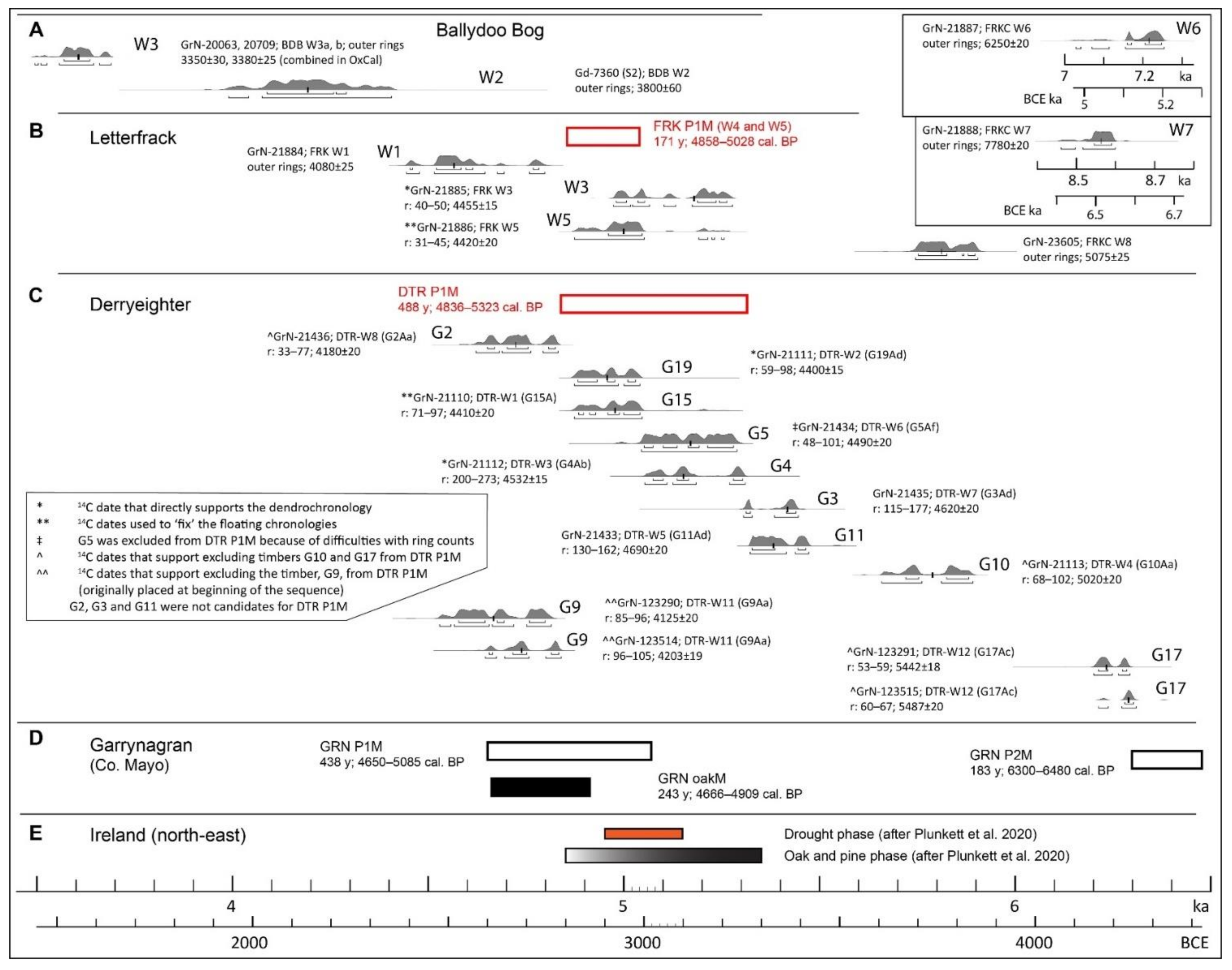
4.3.3. Letterfrack, Connemara National Park (Pine Dendrochronology and Pollen Profiles)

Pine timbers have been investigated from within the same general area as the pollen profiles [11], and peat humification data are available for two other cores, LET 1 and LET 2, from Letterfrack [79,80,81] (Figure 1B and Figure 2B). The pine timbers are first considered (Figure 14 and Figure S6; Table S5). Three pine timbers have been 14C dated and gave results as follows:
FRK W1, i.e., a stump on ~40 cm of peat located on elevated ground to the south of the Visitor Centre (VC) where shallow blanket bog has been largely cut away. Timber from the outer rings yielded the date 4080 ± 15 BP, which suggests that the tree died at c. 4.6 ka;
FRK W5, i.e., the large stump close to core FRK II. Rings 31–45 yielded the date 4420 ± 20 BP, which indicates that the pine tree began life before/at c. 5 ka. It died some 180 y later;
FRK W3, i.e., the largest stump and longest-lived tree (>180 y) in the basin and ~80 m distant from FRK II and FRK W5, yielded the date 4455 ± 15 BP (rings 40–50). This suggests that the tree probably began life before 5 ka and hence was contemporaneous with FRK W5 (the prefixes FRK and FRKC are generally omitted from the timber samples that derive from Letterfrack from here on).
Ring-width patterns in timbers W3–W5 gave a significant cross-match only between W4 and W5. From these cross-matching timbers, the floating standard chronology FRK P1M was constructed. This spans the interval 4858–5028 cal. BP, i.e., 171 years (the 14C date from W5 was used to ‘fix’ the floating chronology [11]). W4 and W5 began life at approximately the same time (both grew on >1 m of peat), but W4 lived for only ~100 y. W4 and W3 gave mean ring widths of 1.47 ± 0.73 and 3.25 ± 1.34 mm, respectively. During the overlap period of W4 and W5, the latter also had wide rings (rings 1–70: 1.63 ± 0.76 mm), but subsequently, the rings were much narrower (rings 71–180: 0.59 ± 0.30 mm) (Figure S6). This suggests that growing conditions on the bog became unfavourable for W5 (but did not result in death) and probably led to death of both W3 and W4. Conditions, however, were not such as to prevent establishment and growth of W1 (outside the basin, on higher ground) some years later (Figure 14). It should be borne in mind that age determinations are available for only four timbers out of the many timbers present in the basin bog (only pine recorded).
Regarding bog-pines W6, W7, and W8, these timbers, which have been brought to the VC from lowland blanket bog sites in Counties Mayo and Galway, are included for the sake of completeness (Table 1; Figure 1A and Figure 14). Timbers W6 and W7 are from a blanket bog context, 30 km to the north-east in Co. Mayo. The 14C dates (from outer rings) indicate that these trees are older than all 14C-dated trees from Co. Galway. W6 (6250 ± 20 BP) died at c. 7.2 ka having lived for about 150 years. Ring-width measurements on four radii gave consistent results but these did not cross-match with any other sequence, including those from Garrynagran, Co. Mayo [11]. W7 (7780 ± 20 BP) died at c. 8.55 ka, i.e., considerably before the oldest known pine from Cos. Mayo or Galway (cf. G42 from Garrynagran; wood centred on ring 82 dated to 6315 ± 25 BP; total no. of rings: 250; [11,59]). The date provided by W7, the wide spread of pine dates from Co. Mayo [59], and indeed, the suite of dates presented here serve to emphasise that bog-pine in mid-western Ireland was a phenomenon that extended over several millennia. This makes its failure to extend into the later Holocene, i.e., the last three millennia, all the more remarkable. Lack of seed sources, due to the wide-scale demise of pine, has undoubtedly played a role (cf. [82]), but it was hardly decisive given the facility with which P. sylvestris and other trees have colonised lake-islands in Connemara since the early twentieth century as population and grazing pressures greatly declined [83]. A substantial shift in climate, which led to a widespread increase in bog surface wetness brought about by increased precipitation, probably combined with lower temperatures, was probably critical. The shift seems to have commenced shortly after 5 ka, so that by 4.5 ka, pine and oak growing on bogs were probably quite rare.
In addition to the pine timbers (especially W1, W3, and W4, which provide terminus ante quem dates for blanket bog growth), further pointers to the age of blanket bog initiation and spread at Letterfrack, as well as late Holocene climate change, are provided by peat-humification studies and short pollen profiles FRK III and FRK IV. Two short cores, LET 1 and LET 2 (~1 m long), yielded similar peat-humification data, based on which it has been suggested that late Holocene climate changes, including the Maunder, Spörer, and Wolf minima (c. 1630–1700, 1400–1540; 1300–1345, respectively) and the early Medieval Warm Period (c. 1100–1300) are well expressed in these cores (Wolf minimum is not reflected in LET 2 [79,80,81,84]; intervals cited here (in CE years), follow these publications). Sufficient information (three 14C dates and a surface date) is available for core LET 1 to enable an age–depth curve to be constructed using Clam. This suggests that the basal peat dates to 4.76 ka, which may be regarded as the date for initiation of peat growth at the sampling point.
Regarding the three pollen profiles from the extensive bog to the south of the VC, the main data are now reviewed. FRK II and IV are summarised in Figure 15; the three profiles, together with additional dating information, are available in Figures S2 and S3; for earlier accounts see [8,27]. Profile FRK II spans most of the Holocene. The age/depth model, based mainly on the available 14C dates (11), suggests accumulation rates in the basal peat deposits of ~0.6 mm y−1 and lower but regular accumulation in the mid and upper parts (mainly between 0.4 and 0.26 mm y−1) (Figure S2). There is a well-defined elm decline and pine flush, which, according to the age/depth model, date to c. 5.1 and 4.6 ka, respectively, i.e., younger than expected. The dates for the pine timbers reported on above (especially W5 from beside FRK II; also W3 and W4) provide a clear indication that the local pine-flush phenomenon was about three centuries earlier than the age/depth model suggests. If this is correct, then it is quite likely that the age of the elm decline (also the weak Neolithic landnam feature that follows), as derived from the age/depth model for FRK II, underestimates by some several centuries the age of the elm decline and also Neolithic landnam. Similarly, a feature near the top of the profile that is interpreted as the Late Iron Age Lull (LIAL) may be too young (see Discussion).
Despite uncertainties regarding the precise chronology, profile FRK II provides several useful insights into local vegetation dynamics. Pine was the dominant tall-canopy tree for much of the Holocene (9.5–4.2 ka), with a major decline recorded at 4.1 ka (from >10% to ≤4%), and a further threshold is crossed at 2.2 ka, when values fall to 0.1%. Hazel was also very important, though its role in the later Holocene may be considerably less than the Corylus/Myrica curve suggests (Figure S2). In the early Holocene, the mire vegetation was initially dominated by tall sedge communities (Magnocaricion) and later by birch (9.9–9.7 ka). Calluna was important for most of the Holocene, both on the mire and probably also in woodlands on mineral soil [85]. The pollen and macrofossil records show that typical blanket bog species, such as E. tetralix and N. ossifragum, have a long history in the area.
Profiles FRK III and IV are from blanket bog as distinct from basin-peat contexts. The 14C-based dating evidence suggests that the organics within the mineral soils at both sites are of similar age, i.e., no younger than c. 3.5 ka (mid-Bronze Age) (Figure S3). As regards FRK IV profile (from the overlying peat; the record extends to recent times), the chronology relies on three 14C dates and best estimates for the age of the surface peat (1960 CE, i.e., when peat probably ceased to accumulate as a result of active erosion of the underlying drift deposit by the meandering Owengarve river) and the initial indications of the secondary rise of Pinus (1750 CE). The pollen spectra from the mineral soils suggest that, prior to the soils being sealed by local bog development, they carried woodlands with oak, hazel, birch, alder and pine. Holly, ivy, rowan (it is assumed that the Sorbus pollen derives mainly from S. aucuparia), and ferns were important at FRK IV. At FRK III, on the other hand, it appears to have been rather open (Poaceae, P. lanceolata, bog taxa and micro-charcoal are well represented) due probably to the impact of pastoral farming. The basal peat at both sites dates to c. 3.3 ka and seems to have been initiated at a time of low human impact that facilitated not only regeneration of trees and shrubs (especially rowan and holly at FRK III and IV, respectively) but also initiation of peat accumulation.
The blanket-peat derived spectra in FRK IV have several interesting features (Figure 15 and Figure S3). At −9 cm (2.82 ka), there is an exceptional peak in P. lanceolata (42.1%), generally elevated NAP values (apart from Poaceae) and the lowest AP in the profile. This is interpreted as reflecting intensive, pastoral farming in the late Bronze Age. Given the major decline in AP, this peak in activity may be of regional and local significance. Apart from this fluctuation, AP curves in the peat samples show relatively little variation. The AP appears to have a considerable long-distance transported component, a view supported by the consistent records for Fagus and Carpinus, which are usually regarded as non-native, i.e., late introductions to Ireland [16] (for a contrary view, see [86]). The very low values for Pinus (mostly 0.1–0.3%) that commence at c. 2.7 ka and continue to near the top of the profile are likewise interpreted as due to long-distance transport, as pine was probably locally and regionally extinct at this time [60,85]. As regards changes in bog-surface wetness, as has been postulated on the basis of investigations at LET 1 and LET 2 (see above), changes in bog taxa representation in FRK IV are relatively subdued. Two spectra that relate to c. 1500–1700 CE (subzone FRK IV-4b) show depressed Calluna and elevated Cyperaceae (incl. Rhynchospora) values, and the E. cinerea record is interrupted. These changes point to increased wetness that may be a consequence of general climate deterioration that followed the early Medieval warm period [87]. More detailed analyses are, however, desirable before firm conclusions regarding climate change are reached. Samples in this part of the profile are integrating ~70 years of pollen deposition, and a better constrained chronology is also desirable.

4.4. Results of Investigations of Pine Timbers at Derryeighter, Eastern Connemara

The 14C and dendrochronological data are summarised in Figure 14 and Figure S6, and additional details are available in Table S6. In all, 20 timbers were investigated, i.e., G1–G20 (locations in Figure 3C). Timbers G7, G8, and G14 had short ring sequences, i.e., about 60 y, which was regarded as insufficient for secure ring-width matching [11]. Fourteen and five timbers had life spans of >100 y and >200 y, respectively.
Bark was not observed in any sample that was dendrochronologically investigated. A heartwood/sapwood boundary was observed only in G4, G2, and G3. In 16 samples, the centre was still intact; in the other samples, centres had rotted, probably due to weathering after removal of the overlying peat. Some samples proved extremely difficult to measure ring widths, as the rings were very narrow, and in some timbers, rings appeared to be prone to splitting several times resulting in two to four additional rings. In G1, G3, and G13, although every attempt was made to obtain an accurate ring-width pattern, the difficulties encountered were such that it was not possible to obtain, with confidence, a mean ring-width sequence. Master chronology DTR P1M spans 4836–5323 cal. BP, i.e., 488 y (note: Jennings [11] gives 4836–5351 cal. BP, i.e., 516 y; G9 has subsequently been excluded on the basis of 14C dating; see Figure 14). DTR P1M includes G9 and G18, and G15 and G19. The individual timbers of these pairs cross-matched and are connected by the long-lived G4, which is the main sequence in DTR P1M. 14C dates are available for four of these timbers (G18 was not 14C dated), and the 14C dates obtained support the validity of DTR P1M (Figure 14). The floating chronology is ‘fixed’ by the date 4420 ± 20 from G5, which has a narrow calibrated range (5047–4874 cal. BP, 2σ probability).
The twelve 14C dates (includes duplicate dates from G9 and G17) and the floating chronology suggest that the pine trees at Derryeighter are concentrated in the interval c. 4.5–5.5 ka (trees G10 and G17 excluded from consideration). During this 1000 y interval, it can reasonably be assumed that living bog-pine was continuously present locally (especially if G3 and G11, that are not part of DTR P1M, are included). If G10 and G17 are included (these trees lived for c. 160 y), then the pine record at Derryeighter begins as early as c. 6.4 ka. These older trees, however, appear to be outliers and do not overlap in time.

5. Discussion

The pollen profiles that are presented here include the long profile BDB I from Ballydoo Bog, and profiles from RLC as follows: (a) a long (DYR V) and five short profiles (DYR I–III, VI and VIIc) from Derryinver, (b) a long (FRK II) and two short (FRK III and IV) profiles from Letterfrack (CNP), and from further west (c) short profiles CNR I (Crocknaraw), and CLD I and II (Claddaghduff). These data are supplemented by 14C dates of pine timbers from Ballydoo Bog, Derryeighter and Letterfrack, and dendrochronological investigations of pine timbers from Derryeighter and Letterfrack.
Though the two lowland areas, i.e., Ballydoo and RLC in north-east and north-west Connemara, respectively, to which the pollen investigations relate are less than 50 km apart, they are physically well separated by the uplands of the southern Joyce Country, the Maumturk Mountain Range, and the Twelve Bens (Figure 1B). The geology of the two regions, however, is broadly comparable. Schists of varying composition dominate and, in many places, are overlain by glacial deposits and bog, including extensive shallow blanket bog and basin bogs, the latter having peat deposits that may be several metres thick. These two study areas also form contrasting sub-regions, in that RLC has a decidedly more Atlantic climate. It has greater exposure to the prevailing strong westerlies; winters are somewhat milder winters (6–7 °C vs. 5–6 °C) but summer temperatures are similar (14–15 °C). Precipitation (mainly rain) averages ~1600 mm y−1 but is less in north-western coastal areas (based on 1981–2010 data; [88]). The two areas have contrasting archaeology, insofar as the main concentration of megaliths (court tombs and dolmens from the early Neolithic tombs, wedge tombs datable to the late Neolithic/early Bronze Age), standing stones (single, pairs and rows; probably Bronze Age), and pre-bog walls (mainly undated but see below) are recorded in the RLC area (Gibbons and Higgins 1988; Figure 1B), while the rest of Connemara has yielded little by way of field records apart mainly from crannogs, i.e., lake settlements that are usually regarded as relating to the Medieval period [21,22]. Crannogs are known from both study areas; e.g., Tully L. in Renvyle and Ballydoo L. [5].
In this discussion, the emphasis is placed on vegetation and landscape developments in the mid- and late Holocene, i.e., from c. 6.3 ka onwards. This date is taken as start point for the summary pollen profiles that are plotted in Figure 15. Selected curves from the main profiles, i.e., curves that show considerable change and/or that are most informative in terms of human impact (P. lanceolata and cereal-type; the latter only if there is a substantial record) are plotted. The profiles are plotted to their own particular time scale. These have their own strengths and weaknesses depending on the number and reliability of the 14C dates, and other indicators of age such as the ages assigned to the bottom and top of the profiles when these can be estimated with reasonable certainty (see Results).
Various features are indicated in Figure 15 (see key in inset), including critical developments in the history of pine and various cultural phases in prehistory and the historical period, e.g., those associated with substantially increased levels of farming including Neolithic Landnam, the Neolithic/Bronze Age transition, the LIAL, and medieval and post-medieval farming impacts. Given the spatial spread of sites, differences in the expected levels of human impact and the varying degrees of chronological constraint, and differences in density of sampling within and between cores, precise synchroneity cannot be expected even if developments happened to be synchronous across the region. Unfortunately, there is no way of independently determining the accuracy of any of the time scales. In the case of FRK II, however, pine stumps that have been dated by 14C and/or dendrochronologically from close to where the profile was taken provide an independent indicator of age for the mid-part of the profile. This suggests that the pine-flush date derived from the age/depth model is too young, and the same probably applies to the Mesolithic/Neolithic transition and elm decline (centuries rather than decades are probably involved; see Results). Despite these limitations and other considerations, including differences arising from whether the profiles are local (e.g., BDB I, DYR V, VI and VIIc, and CLD I) or regional (e.g., FRK II and the mid/upper part of FRK IV) in character, the data provide several useful insights into Holocene vegetation dynamics and human impact at local and regional levels that are now discussed.
The importance of pine during the early and mid-Holocene is obvious from all profiles, particularly in BDB I, where Pinus is at 20–40% for much of the period. It should be borne in mind, however, that pine timbers are plentiful in Ballydoo Bog, so that these presumably make a substantial pollen contribution especially when Pinus values >40% are achieved (8.4, 6.25 and 5.6 ka; >30% at c. 4.9 ka). Oak, hazel, and birch are also important, while alder is probably largely confined to wet habitats (BDB I and DYR V, Figure 6, Figure 7 and Figure 11; also CLD I, Figure 15). Elm, on the other hand, plays only a minor role, as is also the case with Fraxinus and Taxus in the mid- and later Holocene. Indeed, the paucity of Taxus records is striking, given that yew is known to play an important role at several sites in Connemara and the wider region at c. 5 ka [60,89].
A peak in Pinus, dating to between 5 and 4 ka, is recorded in most profiles (see BDB I, DYR V, and FRK II; also CNR I; Figure 15). These peaks are regarded as indicative of a pine flush, i.e., establishment and growth of pine on blanket bog surfaces or on mineral ground at a time of rapid local expansion of blanket bog that resulted in the preservation of pine timbers. In general, the pollen profiles from Connemara and elsewhere indicate a later date for the pine flush than that suggested by 14C dates derived from pine timbers (cf. [59]). The younger than expected dates from blanket bog profiles may be related to use of bulk peat samples for 14C dating. These inevitably include rootlets of younger age (also humic acids) than the pollen and other organic material that constitutes the main peat matrix.
After the pine flush, the Pinus curve generally falls quickly to low values, and this is followed by a two-step decline that is marked P2 and P3 in Figure 15. The former is interpreted as the demise of pine to a minor woodland component, while the latter may be interpreted as indicating regional extinction. Pinpointing these developments in the pollen record is accompanied by several difficulties, not least the variability in percentage pollen values depending on local conditions and especially local site characteristics [90,91]. It is therefore not surprising that there is considerable variation in the dates associated with these developments (Figure 15). P2 generally occurs at c. 3.4 ka, while P3 occurs within a little over a thousand years (c. 2.3 ka). Interestingly, these developments are recorded considerably earlier at BDB I where, in earlier times, pine was particularly important, though possibly on the bog rather than in woodlands on mineral soils (see above).
The course of human impact, which invariably finds good expression in pollen records, especially after the commencement of farming in the early Neolithic, can readily be followed in the profiles presented here. In Irish pollen diagrams, the elm decline is usually followed by a pronounced landnam event that often starts as early as 5.8 ka and may last for at least two to three centuries ([59,62]). A landnam-type feature is recorded in FRK II though not strongly expressed (P. lanceolata achieves only 3%), but the regional character of this profile should be borne in mind. In DYR V, the impact is greater (P. lanceolata achieves 7.5%) and probably of longer duration (c. 5.55–5 ka). Furthermore, at Derryinver, severe soil erosion is recorded in a nearby profile DYR VIIc that is nearer sloping mineral ground. Given the timing and duration (5.6–5.2 ka) of this erosional event and the lack of evidence for a climatic deterioration or an adverse weather event (the pollen evidence does not indicate such, e.g., there are no major changes in wetland taxa representation) it seems unlikely that climate or weather conditions were responsible. Human impact, involving largely pastoral-based farming and woodland clearances centred on Derryinver hill are the most likely cause. Interestingly, in this context, boulders that may derive from a megalithic tomb are present beside the stone alignment on the hill [5]. From Achill Island, west Mayo, a similar but severer erosional event has been reported on [92]. The event, however, is later (5.2–5.1 ka), and the authors plausibly suggest that it may be connected with severe weather events associated with an overall climate shift towards wetter and cooler conditions that is also signalled in Achill by the demise of pine that followed the pine flush.
A major feature in the records presented here is the increase in farming activity that begins in the interval c. 4.5–4 ka and continues, but with varying intensity, for most of the mid- and late Holocene. The initial surge in activity is presumed to be connected with the general increase in activity associated with the late Neolithic and the transition to the Bronze Age that is strongly pronounced in Ireland [93,94] and many other parts of western Europe [95]. Farming appears to be predominantly pastoral based (cf. FRK III and IV) except at Ballydoo (BDB I), where cereal-type pollen has strong representation, achieving 2.2% at c. 4.1 ka (this and next seven spectra that span to 2.7 ka give an average value of 0.8%). Late Bronze Age farming activity is strongly reflected at Letterfrack (Figure 15; in FRK IV P. lanceolata achieves 42%; farming indicators are also well represented in FRK III (Figure S3)). At Derryinver, elevated levels of activity are recorded both before and after 3 ka in DYR V and at c. 3 ka in DYR VI, which is from the henge-like enclosure. Here, P. lanceolata values of 26.7% and 24.2% from 1.5 cm (mineral-rich material) and −1.5 cm (basal peat), respectively, are recorded (Figure S1). Peat presumably started to accumulate in the ditch shortly after the construction of the ditch and outer enclosing mound. These structures also point to a high level of activity on the hill in the late Bronze Age. The stone alignment on the hilltop nearby may have been constructed at this time (stone alignments are often regarded as pertaining to the late Bronze Age [96,97]). On the other hand, the pre-bog stone wall associated with the alignment was constructed in the mid-Iron Age (2.4 ka on the basis of a 14C date from the mineral soil beneath the wall at profile DYR I), and the pre-bog curved stone wall at DYR III was also laid out at about this time. The pre-bog stone wall on mineral soil at Claddaghduff, however, relates to the mid-Bronze Age (3.84 ka) and was extended onto peat in the late Bronze Age (2.9 ka; profiles CLD I and II; see Results).
The interruption, or at least a substantial lull, in farming that occurs in the late Iron Age, i.e., the LIAL, is the main feature of the late Iron Age/early Medieval transition (transition from prehistory to the historical period in Ireland). The LIAL is known to facilitate regeneration of woody vegetation that may involve various shrubs such as hazel, birch, juniper, and tall trees such as ash and yew (see, for example, [16,59]). At Derryinver, this feature is expressed by a strong regeneration in birch and can be seen especially in DYR V and VI, where it spans the intervals c. 1.6–1.25 ka (350–700 CE) and 1.55–1.15 ka (400–800 CE), respectively. The duration in DYR VI may be exaggerated due to weak chronological constraint of the upper part of this profile, and the dating as provided by the age/depth model in the case of both profiles is younger, by a century or more, than expected on the basis of the evidence from other sites in western Ireland. For example, in profile MOR1 (Inis Oírr, Aran Islands), where the record is chronologically tightly constrained (see [98], Figure 4), a LIAL—expressed by low NAP and a major expansion of Juniperus and Taxus in the final stages—spans the interval 1.86–1.45 ka, i.e., 90 BCE–500 CE [16]. In FRK II (Letterfrack), the LIAL is also well expressed but is centred on the early centuries CE, which is here regarded as the best available approximation for the dating of LIAL in Renvyle and Letterfrack. Accepting this avoids the idea of major asynchroneity in vegetation development and land-use in these adjoining areas that is highly unlikely. Interestingly also, the LIAL has, at best, only weak expression in profiles FRK IV and BDB I. Recent archaeological research shows that the late Iron Age in Ireland is not as devoid of evidence of human activity as was once thought [99,100]. For this and other reasons mainly connected with expression of vegetation developments in pollen diagrams, a LIAL is not necessarily a feature of all pollen profiles that span this period.
The LIAL was followed in the early Medieval period by a substantial and widespread increase in farming that finds expression in all profiles. In DYR V, these developments are particularly well expressed and involve initially farming that was pastoral based, and, in the mid/late Medieval period (beginning at c. 0.9 ka; 1050 CE), a substantial arable component was added. The final stages in the creation of a fully open landscape began shortly after 1 ka (c. 1000 CE) and was completed within about a century at Derryinver, which is similar to records from elsewhere in Connemara, including the uplands at Mám Éan [60].
Another feature documented by the data sets is the development and expansion of blanket bog. At Letterfrack, pine stumps on mineral ground or shallow peat indicate that there was already considerable blanket bog spread on the eastern side of the Owengarve river prior to 5 ka. The profile LET 1 indicates that blanket bog growth had commenced on the western side also rather early (4.76 ka), while on the knoll at Crocknaraw (CNR I), peat had begun to accumulate as early as 6.5 ka. At profiles FRK III and IV, on the other hand, it was not until c. 3.5 ka that peat began to accumulate, while the short profile DYR II from Derryinver hill indicates blanket bog development there occurred as late as c. 1.6 ka (350 CE). While the expansion of blanket bog may be a phenomenon associated with climatic downturn in the late Neolithic/Bronze Age, it has a long history that extends over most of the Holocene, with inception and expansion depending on many factors involving not only climate but also changing soil conditions, land-use, and plant communities.
Dendrochronological investigations of bog-pine at Derryeighter and Letterfrack and 14C dating of bog-pine timbers in these areas and at Ballydoo Bog serve to confirm the importance of bog-pine in the region and particularly in the interval 4.5–5.5 ka. The floating pine chronology GRN P1M from Garrynagran, Co. Mayo falls within the later part of this period (4.65–5.085 ka; oaks also present for much of this period [59]). Plunkett et al. [55] have identified 4.85–5.35 ka and 4.95–5.15 ka as periods in which oak and pine were particularly common on bogs in north-east Ireland, and as drought periods, respectively. It appears that climate—drier and/or warmer—is the main factor giving rise to the phenomenon of bog-timbers in the mid-Holocene. These authors also point to draught phases at 8.15–7.95 and 2.94–2.75 ka, with pine and oak, and oak only, common during the former and latter periods, respectively. From the present study, there is considerable evidence for bog-pine prior to 5.5 ka (G10, G17 and FRKC W6–W8) and from younger periods but less frequently. The youngest pine (W3 from Ballydoo Bog; life span <100 y) died at c. 3.6 ka, which well predates the youngest drought period at 2.94 ka identified by Plunkett et al. [55]. The pollen records suggest that pine persisted in Connemara until c. 2.3 ka, but interestingly, pine appears not to have colonised bog surfaces in the early years of the third millennium BCE, as might be expected in response to the draught period at 2.94 ka. The climate shift may have been insufficient in intensity and/or duration to effect the changes required that would have facilitated regeneration and establishment of pine at this time on bog surfaces that, overall, were probably much wetter than today.

6. Conclusions

Pollen profiles, including three pollen profiles that span most of the Holocene, show the important role played by P. sylvestris in north-east and in north-western Connemara in the early and mid-Holocene. Pine growing on peat surfaces and on mineral ground associated with peat spread was common in the mid-Holocene, especially at c. 5 ka. After this, pine declined rapidly. Subsequent declines of Pinus in the pollen records take place at c. 3.4 ka and again at c. 2.3 ka, the latter leading to the final demise of pine in the region. A wetter climatic regime that became established after 5 ka presumably led to the initial decline, but human impact in the Bronze Age and early Iron Age was probably of crucial importance in the ultimate demise of pine.
Long pollen profiles and several short pollen profiles, as well as secure dates derived from 14C and dendrochronological dating of bog-pine timbers, enable blanket bog development and expansion to be documented at a fine spatial scale. The expansion of blanket bog is shown to be well underway by c. 5.5 ka (early/mid-Neolithic), but it continued locally into the Bronze Age, while at Derryinver hill, spread of blanket bog occurred as late as the mid first millennium CE.
Early Neolithic landnam is recorded at both Derryinver and Letterfrack but not at Ballydoo. For most of the Bronze Age and Iron Age, subsequently, human impact was high, apart from a few centuries in the early first millennium CE, when woody regeneration took place in response to a lull in farming, i.e., the so-called LIAL.
At Ballydoo, a high frequency of charcoal and silt/clay layers in the lower peat deposits (early and mid-Holocene) indicates frequent fires and soil erosion in the catchment. At Derryinver, a pronounced silt layer that was deposited over the interval 5.6–5.2 ka is ascribed to early Neolithic activity located presumably on adjoining sloping mineral soils.
A pre-bog stone wall at Claddaghduff is shown to relate to the Bronze Age. The wall was initiated on mineral ground at 3.84 ka and extended onto peat at 2.9 ka. On Derryinver hill, two pre-bog stone walls were constructed in the mid-Iron Age (c. 2.4 ka). As far as could be ascertained, neither of these stone-wall systems formed regular patterns and enclosures as at the Neolithic stone-wall systems recorded at Céide Fields, north Mayo [59,101].
The creation of the present-day open, treeless landscape is clearly reflected in the long pollen diagrams from Ballydoo and Derryinver. This development is dated to the mid-Medieval period, i.e., the early second millennium CE, and was the result of substantial and sustained increase in farming. These developments are probably connected with the general increase in farming activity at this time in many parts of Ireland, especially those parts that came under Norman control and influence (the Normans arrived in Ireland from southern Britain in 1169 CE and expanded rapidly). Connemara lay outside direct Norman control but was undoubtedly influenced by the substantial Norman presence at its eastern boundary [102].

Supplementary Materials

Figure S1. Pollen profiles, DYR I, II, III, and VI, Derryinver hill, Renvyle. Age/depth curves for DYR II and IV. Figure S2. Percentage pollen diagram FRK II and age/depth curve. Figure S3. Percentage pollen diagrams, FRK III and FRK IV, Letterfrack, and age–depth curve for FRK IV. Figure S4. Pollen profile, CNR I; Crocknaraw, macrofossil diagram and age–depth curve. Figure S5. Pollen profiles, CLD I and CLD II; Claddaghduff; age/depth curve for CLD I and site map. Figure S6. Dendrochronological and 14C data: pine-timbers from Letterfrack and Derryeighter.
Table S1. 14C dates, peat core BDB I, Ballydoo Bog. Table S2. 14C dates, peat cores at Derryinver (DYR series). Table S3. 14C dates, peat core CNR I, Crocknaraw and peat cores CLD I and CLD II, Claddaghduff. Table S4. 14C dates from pine timbers, Ballydoo Bog. Table S5. 14C dates and dendrochronological data from pine timbers, Letterfrack, CNP. Table S6. 14C dates and dendrochronological data from pine timbers, Derryeighter. Table S7. Data from stratigraphical investigations at Ballydoo Bog, Cornamona (in a separate Excel file). Table S8. Overview of pollen assemblage zones in BDB I and reconstruction of vegetation and landscape development at Ballydoo Bog.
Plate S1. Images from Ballydoo, Cornamona. Plate S2. Images from Derryeighter. Plate S3. Images from Derryinver. Plate S4. Images from Letterfrack in CNP. Plate S5. Images from Crocknaraw and Claddaghduff.

Author Contributions

The first draft of the manuscript was written by M.O. who also compiled the data and constructed the figures. The data derive from research supervised by M.O., including investigations towards Ph.D degrees by E.J. and K.M., and other investigations conducted over several years in the PRU, NUIG (formerly UCG). The largest dataset (dendrochronology and pollen) was generated by E.J. in the context of research towards her PhD degree; substantial data derive from research by K.M. towards her PhD degree. K.M. provided helpful comments on the text and figures, and agreed to the submission of the final manuscript. All authors have read and agreed to the published version of the manuscript.

Funding

The research was part funded by Eolas (Irish Science and Technology Agency) (grant number BR/92/034), and the EC [EU] EPECC (European PalaeoEnvironments, Climate and Circulation) project. UCG (NUIG) provided postgraduate fellowships to EJ and KM.

Institutional Review Board Statement

Not applicable.

Informed Consent Statement

Not applicable.

Data Availability Statement

Letterfrack pollen profiles at:
Other pollen profiles are in preparation for uploading to PANGAEA.

Acknowledgments

Assistance with sampling in the field was provided by M. Bowler, C.C. Huang, S. Keane, N. Lockhart, R. McCormack, C. McMahon, P. O’Rafferty, and staff of the Office of Public Works (OPW), Connemara National Park. M. Bowler, C. McMahon and R. McCormack contributed to pollen analytical investigations at Connemara National Park, Ballydoo and Derryinver, respectively. H. Heijnis carried out macrofossil analysis on core FRK II, Letterfrack. M. Baillie and D. Brown (QUB) advised on dendrochronology. J. van der Plicht and colleagues (Groningen) paid particular attention to 14C dating of the pine timbers. M. Gibbons provided guidance to the archeology of Connemara. Landowners, and especially the Nee/McDonagh family of Cluain Lára, Derryinver, and the O’Sullivan family of Derryeighter, facilitated access to sites for sampling purposes. Research by M. Bowler, E. Jennings and K. Molloy was supported by NUIG postgraduate fellowships. OPW funded the palaeoecological investigations in the CNP and at Crocknaraw. Investigation of bog-pines in western Ireland was supported by Eolas (Irish Science and Technology Agency) (grant BR/92/034) and the EC [EU] EPECC (European PalaeoEnvironments, Climate and Circulation) project. Finally, helpful reviewer comments led to several improvements in the text.

Conflicts of Interest

The authors declare no conflict of interest. The funders had no role in the design of the study; in the collection, analyses, or interpretation of data; in the writing of the manuscript, or in the decision to publish the results.

References

  1. Leake, B.E.; Tanner, P.W.G.; Senior, A. The Geology of Connemara [1: 63,360 Geological Map; 1″ = 1 Mile]; University of Glasgow: Glasgow, UK, 1981. [Google Scholar]
  2. Morris, J.H.; Long, C.B.; McConnell, B.; Archer, J.B. Geology of Connemara; Geological Survey of Ireland: Dublin, Ireland, 1995. [Google Scholar]
  3. Webb, D.A.; Scannell, M.J.P. Flora of Connemara and the Burren; Royal Dublin Society and Cambridge University Press: Dublin, Ireland; Cambridge, UK, 1983. [Google Scholar]
  4. Gibbons, M.; Higgins, J. Connemara’s emerging prehistory. Archaeol. Irel. 1988, 2, 63–66. [Google Scholar]
  5. Gosling, P. Archaeological Inventory of County Galway. Volume 1: West Galway; Government Stationery Office: Dublin, Ireland, 1993. [Google Scholar]
  6. Robinson, T. Twilight on old stones. Field Day Rev. 2007, 3, 43–51. [Google Scholar]
  7. Molloy, K.; O’Connell, M. The nature of the vegetational changes at about 5000 B.P. with particular reference to the elm decline: Fresh evidence from Connemara, western Ireland. New Phytol. 1987, 106, 203–220. [Google Scholar] [CrossRef]
  8. O’Connell, M.; Molloy, K.; Bowler, M. Post-glacial landscape evolution in Connemara, western Ireland with particular reference to woodland history. In The Cultural Landscape—Past, Present and Future; Birks, H.H., Birks, H.J.B., Kaland, P.E., Moe, D., Eds.; Cambridge University Press: Cambridge, UK, 1988; pp. 487–514. [Google Scholar]
  9. Molloy, K.; O’Connell, M. Palaeoecological investigations towards the reconstruction of woodland and land-use history at Lough Sheeauns, Connemara, western Ireland. Rev. Palaeobot. Palynol. 1991, 67, 75–113. [Google Scholar] [CrossRef]
  10. Molloy, K.; O’Connell, M. Early land use and vegetation history at Derryinver Hill, Renvyle Peninsula, Co. Galway, Ireland. In Climate Change and Human Impact on the Landscape; Chambers, F.M., Ed.; Chapman and Hall: London, UK, 1993; pp. 185–199. [Google Scholar]
  11. Jennings, E. Palaeoecological Studies towards the Reconstruction of the Holocene History of Pinus sylvestris L. in Western Ireland. Ph.D. Thesis, National University of Ireland Galway (NUIG), Galway, Ireland, 1997, unpublished. [Google Scholar]
  12. Huang, C.C.; O’Connell, M. Recent land-use and soil-erosion history within a small catchment in Connemara, western Ireland: Evidence from lake sediments and documentary sources. Catena 2000, 41, 293–335. [Google Scholar] [CrossRef]
  13. Huang, C.C.; O’Connell, M. Erratum to “Recent land-use and soil-erosion history within a small catchment in Connemara, western Ireland: Evidence from lake sediments and documentary sources”. Catena 2001, 43, 349–350. [Google Scholar] [CrossRef]
  14. Cunningham, J.D.; MacNeill, G.; Pollard, D. Chernobyl Its Effect on Ireland; Nuclear Energy Board: Dublin, Ireland, 1987; Available online: https://inis.iaea.org/search/search.aspx?orig_q=RN:19058507 (accessed on 24 September 2021).
  15. Fairlie, I. Dispersal, deposition and collective doses after the Chernobyl disaster. Med. Confl. Surviv. 2007, 23, 10–30. [Google Scholar] [CrossRef]
  16. O’Connell, M.; Molloy, K. Aran Islands, western Ireland: Farming history and environmental change reconstructed from field surveys, historical sources, and pollen analyses. J. N. Atl. 2019, 38, 1–27. [Google Scholar] [CrossRef] [Green Version]
  17. Leake, B.E. A new map and interpretation of the geology of part of Joyces Country, Counties Galway and Mayo. Ir. J. Earth Sci. 2014, 32, 1–21. [Google Scholar] [CrossRef]
  18. Atherton, I.; Bosanquet, S.D.S.; Lawley, M. (Eds.) Mosses and Liverworts of Britain and Ireland. A Field Guide; British Bryological Society: Plymouth, UK, 2010. [Google Scholar]
  19. Parnell, J.; Curtis, T. Webb’s an Irish Flora, 8th ed.; Cork University Press: Cork, Ireland, 2012. [Google Scholar]
  20. Legg, R.; Ludlow, F.; Travis, C. Mapping the Irish rath (ringfort): Landscape and settlement patterns in the early Medieval period. In Historical Geography, GIScience and Textual Analysis: Landscapes of Time and Place; Travis, C., Ludlow, F., Gyuris, F., Eds.; Springer International Publishing: Cham, Switzerland, 2020; pp. 197–210. [Google Scholar]
  21. O’Sullivan, A. Crannogs. Lake-Dwellings of Early Ireland; Country House: Dublin, Ireland, 2000. [Google Scholar]
  22. Fredengren, C. Crannogs. A Study of People’s Interaction with Lakes, with Particular Reference to Lough Gara in the North-West of Ireland; Wordwell: Bray, Ireland, 2002. [Google Scholar]
  23. Robinson, T. Connemara. Part 1: Introduction and Gazetteer. Part 2: A One-Inch Map; Folding Landscapes: Roundstone, Ireland, 1990. [Google Scholar]
  24. Molloy, K. Palaeoecological Investigations towards the Reconstruction of Prehistoric Human Impact in N.W. Connemara, Western Ireland. Ph.D. Thesis, University College Galway [UCG; now NUIG], Galway, Ireland, 1989, unpublished. [Google Scholar]
  25. McCormack, R.F. Further Palaeoecological Investigations towards the Reconstruction of Vegetation and Land-Use History at Derryinver, Rinvyle, N.W. Connemara. Bachelor’s Thesis, Department of Botany, UCG [NUIG], Galway, Ireland, 1991, unpublished. [Google Scholar]
  26. Bowler, M. A Vegetation History of Connemara National Park, Co. Galway. Master’s Thesis, Department of Botany, UCG [NUIG], Galway, Ireland, 1986, unpublished. [Google Scholar]
  27. O’Connell, M. Origins of Irish lowland blanket bog. In Ecology and Conservation of Irish Peatlands; Doyle, G.J., Ed.; Royal Irish Academy: Dublin, Ireland, 1990; pp. 49–71. [Google Scholar]
  28. Hawkes, A. The beginnings and evolution of the fulacht fia tradition in early prehistoric Ireland. Proc. R. Ir. Acad. 2014, 114C, 89–139. [Google Scholar] [CrossRef]
  29. Lundholm, A.; Corrigan, E.; Black, K.; Nieuwenhuis, M. Ecosystem services provision from alternative management options was modified to Ireland’s western peatland forests under future development scenarios. Ir. For. 2020, 77, 49–73. [Google Scholar]
  30. Jennings, E.M. Reconstruction of Vegetation and Land Use in N.E. Connemara during the Early and Mid Holocene Based on a Peat Profile from North of Ballydoo Lough, Cornamona, Co. Galway. Bachelor’s Thesis, Department of Botany, UCG [NUIG], Galway, Ireland, 1992, unpublished. [Google Scholar]
  31. McMahon, C. Reconstruction of Vegetation and Land Use in N.E. Connemara during the Later Holocene Based on a Peat Profile from North of Ballydoo Lough, Cornamona, Co. Galway. Bachelor’s Thesis, Department of Botany, UCG [NUIG], Galway, Ireland, 1992, unpublished. [Google Scholar]
  32. Beug, H.-J. Leitfaden der Pollenbestimmung für Mitteleuropa und Angrenzende Gebiete. Lieferung 1; Gustav Fischer: Stuttgart, Germany, 1961. [Google Scholar]
  33. Fægri, K.; Iversen, J. Textbook of Pollen Analysis, 3rd ed.; Munksgaard: Copenhagen, Denmark, 1975. [Google Scholar]
  34. Fægri, K.; Iversen, J. Textbook of Pollen Analysis, 4th ed.; Fægri, K., Kaland, P.E., Kryzwinski, K., Eds.; Wiley: Chichester, UK, 1989. [Google Scholar]
  35. Moore, P.D.; Webb, J.A. An Illustrated Guide to Pollen Analysis, 1st ed.; Hodder and Stoughton: London, UK, 1978; p. 133. [Google Scholar]
  36. Moore, P.D.; Webb, J.A.; Collinson, M.E. An Illustrated Guide to Pollen Analysis, 2nd ed.; Blackwell Scientific: London, UK, 1991. [Google Scholar]
  37. Punt, W.; Blackmore, s.; Hoen, P.P.; Stafford, P.J. The Northwest European Pollen Flora, Volumes I–VIII; Elsevier: Amsterdam, The Netherlands, 1976–2003. [Google Scholar]
  38. Mohr, R. Untersuchungen zur nacheiszeitlichen Vegetations- und Moorentwicklung im nordwestlichen Niedersachsen mit besonderer Berücksichtigung von Myrica gale L. VAG Vechtaer Arb. Geogr. Regionalwiss. 1990, 12, 1–144. [Google Scholar]
  39. Birks, H.J.B. Past and Present Vegetation of the Isle of Skye. A Palaeoecological Study; Cambridge University Press: Cambridge, UK, 1973. [Google Scholar]
  40. Beug, H.-J. Leitfaden der Pollenbestimmung für Mitteleuropa und angrenzende Gebiete, 2nd ed.; Friedrich Pfeil: München, Germany, 2015. [Google Scholar]
  41. Van Geel, B. A palaeoecological study of Holocene peat bog sections in Germany and the Netherlands. Rev. Palaeobot. Palynol. 1978, 25, 1–120. [Google Scholar] [CrossRef]
  42. Feeser, I. COUNTPOL. A Computer Program for Processing and Plotting Pollen Data; NUIG: Galway, Ireland; CAU: Kiel, Germany, 2007; unpublished. [Google Scholar]
  43. Beijerinck, W. Zadenatlas der Nederlandische Flora. Ten Behoeve van de Botanie, Palaeontologie, Bodemcultuur en Warenkennis; Backhuys and Meesters: Amsterdam, The Netherlands, 1947. [Google Scholar]
  44. Körber-Grohne, U. Bestimmungsschlüssel für subfossile Juncus-Samen und Gramineen-Früchte. Prob. Küstenforsch 1964, 7, 1–47. [Google Scholar]
  45. Greguss, P. Holzanatomie der Europäischen Laubhölzer und Sträucher, 1st ed.; Akadémiai Kiadó: Budapest, Hungary, 1959. [Google Scholar]
  46. Grosser, D. Die Hölzer Mitteleuropas; Springer: Berlin/Heidelberg, Germany, 1977. [Google Scholar]
  47. Schweingruber, F.H. Anatomie europäischer Hölzer. Anatomy of European Woods; Haupt: Bern, Switzerland, 1990. [Google Scholar]
  48. Blaauw, M. Methods and code for ‘classical’ age-modelling of radiocarbon sequences. Quat. Geochronol. 2010, 5, 512–518. [Google Scholar] [CrossRef]
  49. Bronk Ramsey, C. Deposition models for chronological records. Quat. Sci. Rev. 2008, 27, 42–60. [Google Scholar] [CrossRef] [Green Version]
  50. Bronk Ramsey, C. Bayesian analysis of radiocarbon dates. Radiocarbon 2009, 51, 337–360. [Google Scholar] [CrossRef] [Green Version]
  51. Reimer, P.J.; Austin, W.E.N.; Bard, E.; Bayliss, A.; Blackwell, P.G.; Bronk Ramsey, C.; Butzin, M.; Cheng, H.; Edwards, R.L.; Friedrich, M.; et al. The IntCal20 Northern Hemisphere radiocarbon age calibration curve (0–55 cal kBP). Radiocarbon 2020, 62, 725–757. [Google Scholar] [CrossRef]
  52. Baillie, M.G.L.; Pilcher, J.R. A simple crossdating program for tree-ring research. Tree-Ring Bull. 1973, 33, 7–14. [Google Scholar]
  53. Munro, M.A. An improved algorithm for crossdating tree-ring series. Tree-Ring Bull. 1984, 44, 17–27. [Google Scholar]
  54. Graybill, D.A. Revised computer programs for tree-ring research. Tree-Ring Bull. 1979, 39, 77–82. [Google Scholar]
  55. Plunkett, G.; Brown, D.M.; Swindles, G.T. Siccitas magna ultra modum: Examining the occurrence and societal impact of droughts in prehistoric Ireland. Proc. R. Ir. Acad. 2020, 120C, 23–50. [Google Scholar] [CrossRef] [Green Version]
  56. Lowe, J.J.; Rasmussen, S.O.; Björck, S.; Hoek, W.Z.; Steffensen, J.P.; Walker, M.J.C.; Yu, Z.C. Synchronisation of palaeoenvironmental events in the North Atlantic region during the Last Termination: A revised protocol recommended by the INTIMATE group. Quat. Sci. Rev. 2008, 27, 6–17. [Google Scholar] [CrossRef]
  57. Walker, M.; Head, M.J.; Lowe, J.; Berkelhammer, M.; Björck, S.; Cheng, H.; Cwynar, L.C.; Fisher, D.; Gkinis, V.; Long, A.; et al. Subdividing the Holocene Series/Epoch: Formalization of stages/ages and subseries/subepochs, and designation of GSSPs and auxiliary stratotypes. J. Quat. Sci. 2019, 34, 173–186. [Google Scholar] [CrossRef]
  58. Molloy, K.; O’Connell, M. Post-glaciation plant colonisation of Ireland: Fresh insights from An Loch Mór, Inis Oírr, western Ireland. In Mind the Gap II: New Insights into the Irish Postglacial; Sleeman, D.P., Carlsson, J., Carlsson, J.E.L., Eds.; Irish Naturalists’ Journal: Belfast, Northern Ireland, 2014; pp. 66–88. [Google Scholar]
  59. O’Connell, M.; Molloy, K.; Jennings, E. Long-term human impact and environmental change in mid-western Ireland, with particular reference to Céide Fields—An overview. E G Quat. Sci. J. 2020, 70, 1–32. [Google Scholar] [CrossRef]
  60. O’Connell, M. Post-glacial vegetation and landscape change in upland Ireland with particular reference to Mám Éan, Connemara. Rev. Palaeobot. Palynol. 2021, 290, 104377. [Google Scholar] [CrossRef]
  61. Gaillard, M.-J.; Sugita, S.; Bunting, J.; Dearing, J.; Bittmann, F. Human impact on terrestrial ecosystems, pollen calibration and quantitative reconstruction of past land-cover. Veget. Hist. Archaeobot. 2008, 17, 415–418. [Google Scholar] [CrossRef]
  62. O’Connell, M.; Molloy, K. Farming and woodland dynamics in Ireland during the Neolithic. Biol. Environ. (Proc. R. Ir. Acad. Ser. B) 2001, 101, 99–128. [Google Scholar]
  63. Barber, K.E.; Chambers, F.M.; Maddy, D. Holocene palaeoclimates from peat stratigraphy: Macrofossil proxy climate records from three oceanic raised bogs in England and Ireland. Quat. Sci. Rev. 2003, 22, 521–539. [Google Scholar] [CrossRef]
  64. Swindles, G.T.; Lawson, I.T.; Matthews, I.P.; Blaauw, M.; Daley, T.J.; Charman, D.J.; Roland, T.P.; Plunkett, G.; Schettler, G.; Gearey, B.R.; et al. Centennial-scale climate change in Ireland during the Holocene. Earth-Sci. Rev. 2013, 126, 300–320. [Google Scholar] [CrossRef] [Green Version]
  65. McClatchie, M.; Potito, A. Tracing environmental, climatic and social change in Neolithic Ireland. Proc. R. Ir. Acad. 2020, 120C, 23–50. [Google Scholar] [CrossRef]
  66. Leuschner, H.H.; Bauerochse, A.; Metzler, A. Environmental change, bog history and human impact around 2900 B.C. in NW Germany—preliminary results from a dendroecological study of a sub-fossil pine woodland at Campemoor, Dümmer Basin. Veget. Hist. Archaeobot. 2007, 16, 183–195. [Google Scholar] [CrossRef]
  67. Tauber, H. Differential pollen dispersion and the interpretation of pollen diagrams. Dan. Geol. Unders. II Raekke 1965, 89, 1–69. [Google Scholar]
  68. Overland, A.; O’Connell, M. New insights into late Holocene farming and woodland dynamics in western Ireland with particular reference to the early medieval horizontal watermill at Kilbegly, Co. Roscommon. Rev. Palaeobot. Palynol. 2011, 163, 205–226. [Google Scholar] [CrossRef] [Green Version]
  69. Behre, K.-E. The interpretation of anthropogenic indicators in pollen diagrams. Pollen Spores 1981, 23, 225–245. [Google Scholar]
  70. O’Connell, M. Reconstruction of local landscape development in the post-Atlantic based on palaeoecological investigations at Carrownaglogh prehistoric field system, County Mayo, Ireland. Rev. Palaeobot. Palynol. 1986, 49, 117–176. [Google Scholar] [CrossRef]
  71. Hall, V.A. A study of the modern pollen rain from a reconstructed 19th century farm. Ir. Nat. J. 1989, 23, 82–92. [Google Scholar]
  72. Mitchell, G.F. Studies in Irish Quaternary deposits: No. 7. Proc. R. Ir. Acad. 1951, 53B, 111–206. [Google Scholar]
  73. Mitchell, F.J.G.; Cooney, T. Vegetation history in the Killarney valley. In Ross Island. Mining, Metal and Society in Early Ireland (Bronze Age Studies 6); O’Brien, W., Ed.; Department of Archaeology, NUIG: Galway, Ireland, 2004; pp. 481–493. [Google Scholar]
  74. Doyle, L. Giant Irish Deer and early alder: The significance of a fragment. Seanda 2010, 5, 3. [Google Scholar]
  75. Young, D.S.; Green, C.P.; Batchelor, C.R.; Austin, P.; Elias, S.A.; Athersuch, J.; Lincoln, P. Macrofossil evidence of alder (Alnus sp.) in Britain early in the Late Glacial Interstadial: Implications for the northern cryptic refugia debate. J. Quat. Sci. 2021, 36, 40–55. [Google Scholar] [CrossRef]
  76. O’Connell, M. Early cereal-type pollen records from Connemara, western Ireland and their possible significance. Pollen Spores 1987, 29, 207–224. [Google Scholar]
  77. Cooney, G.; Bayliss, A.; Healy, F.; Whittle, A.; Danaher, E.; Cayney, L.; Mallory, J.; Smyth, J.; Kador, T.; O’Sullivan, M. Ireland. In Gathering Time. Dating the Early Neolithic Enclosures of Southern Britain and Ireland; Whittle, A., Healy, F., Bayliss, A., Eds.; Oxbow Books: Oxford, UK, 2011; Volume 2, pp. 562–669. [Google Scholar]
  78. McClatchie, M.; Bogaard, A.; Colledge, S.; Whitehouse, N.J.; Schulting, R.J.; Barratt, P.; McLaughlin, T.R. Neolithic farming in north-western Europe: Archaeobotanical evidence from Ireland. J. Archaeol. Sci. 2014, 51, 206–215. [Google Scholar] [CrossRef] [Green Version]
  79. Blackford, J.J.; Chambers, F.M. Proxy records of climate from blanket mires: Evidence for a Dark Age (1400 BP) climatic deterioration in the British Isles. Holocene 1991, 1, 63–67. [Google Scholar] [CrossRef]
  80. Blackford, J.J.; Chambers, F.M. Proxy climate record for the last 1000 years from Irish blanket peat and a possible link to solar variability. Earth Planet. Sci. Lett. 1991, 133, 145–150. [Google Scholar] [CrossRef]
  81. Chambers, F.M.; Blackford, J.J. Mid- and late-Holocene climatic changes: A test of periodicity and solar forcing in proxy-climate data from blanket peat bogs. J. Quat. Sci. 2001, 16, 329–338. [Google Scholar] [CrossRef]
  82. McGeever, A.H.; Mitchell, F.J.G. Pine stumps in Irish peats: Is their occurrence a valid proxy climate indicator? J. Quat. Sci. 2015, 30, 489–496. [Google Scholar] [CrossRef]
  83. Hannon, G.E.; Bradshaw, R.H.W. Recent vegetation dynamics on two Connemara lake islands, western Ireland. J. Biogeog. 1989, 16, 75–81. [Google Scholar] [CrossRef]
  84. Chambers, F.M.; Ogle, M.I.; Blackford, J.J. Palaeoenvironmental evidence for solar forcing of Holocene climate: Linkages to solar science. Prog. Phys. Geog. 1999, 23, 181–204. [Google Scholar] [CrossRef]
  85. O’Connell, M.; McDonnell, K. Holocene vegetation history of SW Connemara, Co. Galway with particular reference to Carna and Roundstone [Site A3.6]. In The Quaternary of Western Ireland. INQUA 2019 Field Guide Pre:GL-2; Coxon, P., Ed.; Irish Quaternary Association (IQUA): Dublin, Ireland, 2019; pp. 83–102. [Google Scholar]
  86. Stolze, S.; Monecke, T. Holocene history of ‘non-native’ trees in Ireland. Rev. Palaeobot. Palynol. 2017, 244, 347–355. [Google Scholar] [CrossRef]
  87. Campbell, B.M.S.; Ludlow, F. Climate, disease and society in late-medieval Ireland. Proc. R. Ir. Acad. 2020, 120C, 159–252. [Google Scholar] [CrossRef]
  88. Walsh, S. A Summary of Climate Averages for Ireland 1981–2010. Climatological Note No. 14; Met Éireann: Dublin, Ireland, 2012. [Google Scholar]
  89. O’Connell, M.; Molloy, K. Mid- and late-Holocene environmental change in western Ireland: New evidence from coastal peats and fossil timbers with particular reference to relative sea-level change. Holocene 2017, 27, 1825–1845. [Google Scholar] [CrossRef]
  90. Bennett, K.D. The post-glacial history of Pinus sylvestris in the British Isles. Quat. Sci. Rev. 1984, 3, 133–155. [Google Scholar] [CrossRef]
  91. Fossitt, J.A. Late-glacial and Holocene vegetation history of western Donegal, Ireland. Biol. Environ. (Proc. R. Ir. Acad.) 1994, 94B, 1–31. [Google Scholar]
  92. Caseldine, C.; Thompson, G.; Langdon, C.; Hendon, D. Evidence for an extreme climatic event on Achill Island, Co. Mayo, Ireland around 5200–5100 cal. yr BP. J. Quat. Sci. 2005, 20, 169–178. [Google Scholar] [CrossRef]
  93. McLaughlin, T.R.; Whitehouse, N.J.; Schulting, R.J.; McClatchie, M.; Barratt, P.; Bogaard, A. The changing face of Neolithic and Bronze Age Ireland: A big data approach to the settlement and burial records. J. World Prehist. 2016, 29, 117–153. [Google Scholar] [CrossRef] [Green Version]
  94. Ginn, V.; Plunkett, G. Filling the gaps: A chronology of Bronze Age settlement in Ireland. J. Ir. Archaeol. 2020, 29, 41–61. [Google Scholar]
  95. Feeser, I.; Dörfler, W.; Kneisel, J.; Hinz, M.; Dreibrodt, S. Human impact and population dynamics in the Neolithic and Bronze Age: Multi-proxy evidence from north-western Central Europe. Holocene 2019, 29, 1596–1606. [Google Scholar] [CrossRef] [Green Version]
  96. Lynch, A. Man and environment in south-west Ireland, 4000 B.C.–A.D. 800. BAR Br. Ser. 1981, 85, 1–175. [Google Scholar]
  97. Waddell, J. The Prehistoric Archaeology of Ireland, 3rd ed.; Wordwell: Bray, Ireland, 2010. [Google Scholar]
  98. Holmes, J.A.; Leuenberger, M.; Molloy, K.; O’Connell, M. Younger Dryas and Holocene environmental change at the Atlantic fringe of Europe derived from lake-sediment stable-isotope records from western Ireland. Boreas 2020, 49, 233–249. [Google Scholar] [CrossRef]
  99. Becker, K.; Ó Néill, J.; O’Flynn, L. Iron Age Ireland: Finding an Invisible People. Final Report to the Heritage Council. Project 16365. 2008 Archaeology Grant Scheme. 2008. Available online: https://www.ucd.ie/t4cms/iron_age_ireland_project_16365_pilotweb.pdf (accessed on 7 November 2021).
  100. Cahill Wilson, J.; Standish, C.D. Mobility and migration in late Iron Age and early Medieval Ireland. J. Archaeol. Sci. Rep. 2016, 6, 230–241. [Google Scholar] [CrossRef]
  101. Caulfield, S. Céide Fields and Belderrig valley: Eighty-four years of research. In The Céide Fields. Ireland; Boschiero, P., Latini, L., Caulfield, S., Eds.; Fondazione Benetton: Treviso, Italy, 2018; pp. 55–73. [Google Scholar]
  102. Stout, G.; Stout, M. Early landscapes: From prehistory to plantation. In Atlas of the Irish Rural Landscape, 2nd ed.; Aalen, F.H.A., Whelan, K., Stout, M., Eds.; Cork University Press: Cork, Ireland, 2011; pp. 31–65. [Google Scholar]
Figure 1. Maps showing locations of study areas including details of Ballydoo Bog site. (A) Map of Ireland showing county boundaries. County Galway is shaded. A box indicates the study region depicted in B. (B) Details regarding locations of the study sites. Rectangles indicate areas for which aerial photographs are provided. A closed, black dot indicates a town or village. An open dot indicates Crocknaraw. Other sites, published elsewhere and referred to in the text, are indicated by red closed dots. Megaliths in Connemara are largely confined to the west of the broken, thick line. Dark green indicates afforestation. (C) Aerial photograph centred on Ballydoo Bog. The low-lying (≤40 m asl), drift-covered terrain about Ballydoo Bog supports mostly pastoral farming. Above ~55 m asl, metamorphic bedrock with thin peaty soil-cover dominates. The following are shown: present-day extent of the bog basin, transect along which stratigraphical investigations were carried out, coring locations (including main core BDB I) along the transect, bog-pine samples that were 14C dated, and eskers E1 and E2. Sources of base maps: B, after OpenStreetMap (© OpenStreetMap contributors 2020; distributed under a Creative Commons BY-SA License, accessed using Mapy.cz (www.seznam.cz (accessed on 20 June 2020)). C: aerial photo from OSI Digital Globe 2011–2013 (downloaded from http://map.geohive.ie/mapviewer.html, accessed on 14 January 2021).
Geographies 01 00015 g001
Figure 2. Maps showing locations of investigated sites at Derryinver and Letterfrack. (A) Aerial photograph of Derryinver hill (heathy vegetation on a thin layer of peat) and immediate surrounds. Locations of pollen profiles (6) and archaeological features are indicated. (B) Aerial photograph centred on Owengarve river, Letterfrack. Locations of pollen profiles (FRK II–IV; location of FRK III is a best estimate), investigated pine timbers and Letterfrack court tomb (53.5478, −9.94908; an arrow points to its location) are indicated. FRK W3 was dendrochonologically investigated but it did not match (short-ring sequence; older than other investigated timbers). Lighter areas are dominated by Molinia caerulea; otherwise, Calluna vulgaris tends to dominate; Ulex europaeus is the main tall shrub. The extent of the basin (valley) bog is indicated by a broken line. Source of base maps: ExpertGPS, TopoGrafix edition (https://www.expertgps.com/ (accessed on 23 August 2021)).
Geographies 01 00015 g002
Figure 3. Maps relating to Claddaghduff/Cleggan and Derryeighter. (A) Topographical map of study area at Claddaghduff/Cleggan and (B) aerial photograph showing details including standing stones, stone walls, and pollen profiles at north margin of an extensive blanket bog, north-east of Claddaghduff. (C) Aerial photograph of Derryeighter. Locations (best estimates) of pine timbers that were investigated are shown. Symbols with a dashed outline are used for timbers that were not in situ (these probably derive from, or close to, the locations where recorded). Filled symbols indicate the specimens that were 14C dated. A white zig-zag line indicates samples (four) that cross-matched and that gave the floating chronology DTR P1M. Sources of base maps: ExpertGPS, TopoGrafix edition (https://www.expertgps.com/ (accessed on 23 August 2021)) (A and B), and Mapy.cz (www.seznam.cz; (accessed on 14 August 2021)).
Geographies 01 00015 g003
Figure 4. The stratigraphy along a transect at Ballydoo Bog. Distances and depths are with respect to BDB I. Wood remains are colour coded and indicated by a letter where space permits; darker shading and bold are used to indicate substantial wood. Abbreviations: My: Myrica wood; P1 (and a separate box): pine timber could not be penetrated so a new borehole was made; P2: pine cone; Ev: Eriophorum vaginatum fibres; Ph: Phragmites; 20: probably secondary peat.
Geographies 01 00015 g004
Figure 5. Age–depth plot and stratigraphy (key to stratigraphy in Figure 4), profile BDB I (Ballydoo Bog). Clam (ver. 2.3.8) was used to fit an age/depth curve (solid line; shaded area indicates uncertainly range) to the labelled points (ages are derived from calibrated 14C dates and pollen stratigraphy; details on figure and in the text). 14C dates, considered to be unreliable and hence not used, are indicated by ‘x’ (positions based on median ages as given by OxCal; see Table S1). The inset shows details of 14C dates of pine timbers. For these dates, the probability outputs from OxCal (probability curve, 1σ and 2σ ranges, and median age (given in brackets)) are positioned relative to the x-axis. The two GrN dates (combined in OxCal) relate to timber from the same tree rings, and, as expected, the dates are similar. The two Gd dates are from contiguous rings. The date from the outer rings (in red) is rejected for being too young (see text).
Geographies 01 00015 g005
Figure 6. Percentage pollen diagram, Ballydoo Bog (BDB I), lower part of profile (c. 11.8–4.67 ka). The data are plotted to an age scale. Percentage scales for the curves are the same throughout, apart from Sphagnum where the scale is halved. Silhouettes show values magnified by 10. ‘+’ indicates records from outside routine pollen counting. Occasional records, consisting either of a record from outside the count or <0.5%, are indicated by a dot and the taxon name (abbreviated).
Geographies 01 00015 g006
Figure 7. Percentage pollen diagram, Ballydoo Bog, upper part of profile (c. 4.67–0.23 ka). Conventions are as in Figure 6.
Geographies 01 00015 g007
Figure 8. Macrofossil, charcoal, loss-on-ignition, stratigraphy, PAZs, sediment accumulation rates and pollen percentage (composite AP and NAP1 curves), and concentration and accumulation rate data for profile BDB I, Ballydoo Bog are plotted to a depth scale. Ages of zone and subzone boundaries are indicated (ka and corresponding calendar years are given; BC, AD = CE, BCE). In the plots of NAP1 pollen concentration and accumulation rate data, exaggeration factors of ×2 and ×20, respectively, with respect to AP are used (see upper x-axes). For key to stratigraphy, see Figure 4.
Geographies 01 00015 g008
Figure 9. Percentage pollen data, Ballydoo Bog. Selected data relating to four surface pollen samples and the upper part of profile BDB I (drawn to depth scale) are plotted. Ages may be regarded as indicative. In open histograms, the x-axis scales are magnified ×10. Reduced scales (halved) are used for Poaceae, Calluna, and Cyperaceae. ‘+’ records are plotted as 0.05%. Surface pollen samples, derived from S. papillosum moss polsters, were collected in January 1992.
Geographies 01 00015 g009
Figure 10. Age–depth plot, stratigraphy and pollen assemblage zones, profile DYR V, Derryinver. Clam (ver. 2.3.8) was used to fit an age/depth curve (solid line; shaded area indicates uncertainly range) to seven conventional 14C dates and four points based on pollen stratigraphy (see text). Four 14C dates that were rejected, because they are unrealistically young, are shown in red font.
Geographies 01 00015 g010
Figure 11. Percentage pollen diagram DYR V from Derryinver (drawn to depth scale). Silhouettes show values magnified by 10. ‘+’ indicates records from outside routine pollen counting. Y-axis scales are the same throughout, apart from curves for Sphagnum and micro-charcoal, where the scale is halved. Dates between 6 ka and 10 ka should be regarded as tentative (see text). The intervals spanned by the nearby profile, DYR VIIa, and the Late Iron Age Lull (LIAL; zone 7) are indicated.
Geographies 01 00015 g011
Figure 12. Additional records for profile DYR V, Derryinver, plotted to a depth scale. Abundances (histograms; values 1–3; ‘+’ plotted as 0.5) are given for the main macrofossil taxa and macro-charcoal fragments. Records indicated by abbreviations (given within brackets) are as follows: Alnus (fr) [Al], Betula (fr) [Be], Cyperaceae (Ach) [Cy], Galium (s) [Ga] and Potentilla (2) ([Pt]; mainly P. palustris; some specimens too eroded to identify to genus). Percentage values of NPPs, including epidermal fragments of seed of E. tetralix and micro-charcoal fragments (both recorded in the pollen samples), are shown. Summary percentage pollen curves are given; the curve for NAP2 (arable disturbed taxa) is exaggerated ×10 (top scale). Weighted means (three points; mid-point double weighted) for AP and NAP1 concentrations are plotted. For key to stratigraphy, see Figure 10. Dates with an asterisk should be regarded as tentative.
Geographies 01 00015 g012
Figure 13. Percentage pollen profile DYR VIIc, Derryinver (drawn to depth scale). Histograms, filled and non-filled, are drawn to either standard and magnified x-scales (×10 and ×20, respectively). A few minor pollen taxa are omitted. Remains recorded in sievings of pollen samples are indicated by circles the size of which reflect abundance values (see key). Macrofossil records: (a) = fern annulus (P. vulgare-type and an unidentified type recorded) and (s) = seed. Ash values, 14C dates, and calibrated ages (to nearest 10 y) based on 14C dates and assuming a linear accumulation rate between the dated points, are indicated (see also the text).
Geographies 01 00015 g013
Figure 14. Chronological data relating to bog-pine timbers from Ireland discussed in this paper. Calibrated 14C dates are shown, including 1σ and 2σ ranges and median age for each date (after outputs from OxCal v. 4.4 and IntCal20). Boxes are used to indicate floating bog-pine chronologies for Ballydoo Bog (A), Letterfrack (B), Derryeighter (C), Garrynagran (D), and phase with high frequency of bog-oak and bog-pine timbers from north-east Ireland (based on dendrochronological data, [55]) and a drought period as proposed by the same authors [55] (E). Three outlier 14C dates are shown in the top inset. Bog-pines, FRKC W6 and FRKC W7, are from west Mayo; these timbers, and FRKC W8 from Corboley, north of Barna, Connemara, are at the Visitor Centre, Connemara National Park.
Geographies 01 00015 g014
Figure 15. Percentage pollen diagrams (peat/mineral soil profiles; selected curves) from a west–east transect, north central Connemara, plotted to a time scale (c. 6.2 ka to recent). In the case of low values, a ×10 magnified x-axis scale is used, and histograms are not filled. In profile CNR I, the basal spectrum is shown by positioning it higher than its age requires. In FRK II, Corylus and Myrica pollen are combined in a single curve; the individual contributions of these taxa are indicated in the case of two spectra within the LIAL. The uppermost sample from Ballydoo Bog consists of average values from the four surface pollen samples. Key features in each profile are indicated (see key to signatures and the text). A question mark indicates that the event is poorly defined in the pollen record.
Geographies 01 00015 g015
Publisher’s Note: MDPI stays neutral with regard to jurisdictional claims in published maps and institutional affiliations.

