Surface Geomorphological Features of Deep-Seated Gravitational Slope Deformations: A Look to the Role of Lithostructure (N Apennines, Italy)


Abstract
:1. Introduction
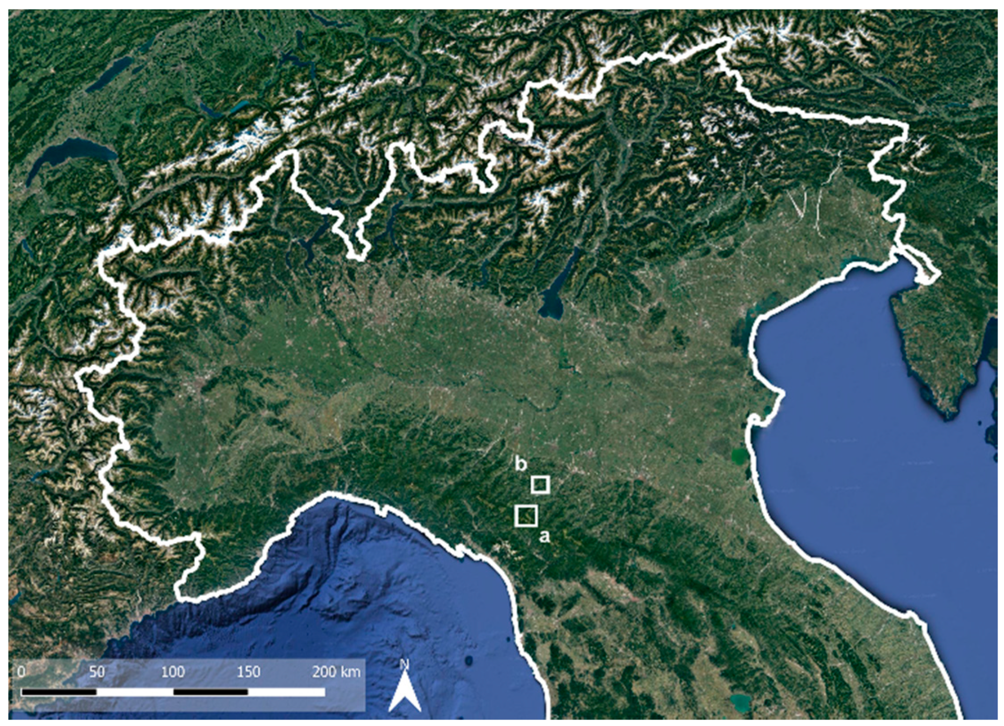
2. The Study Area
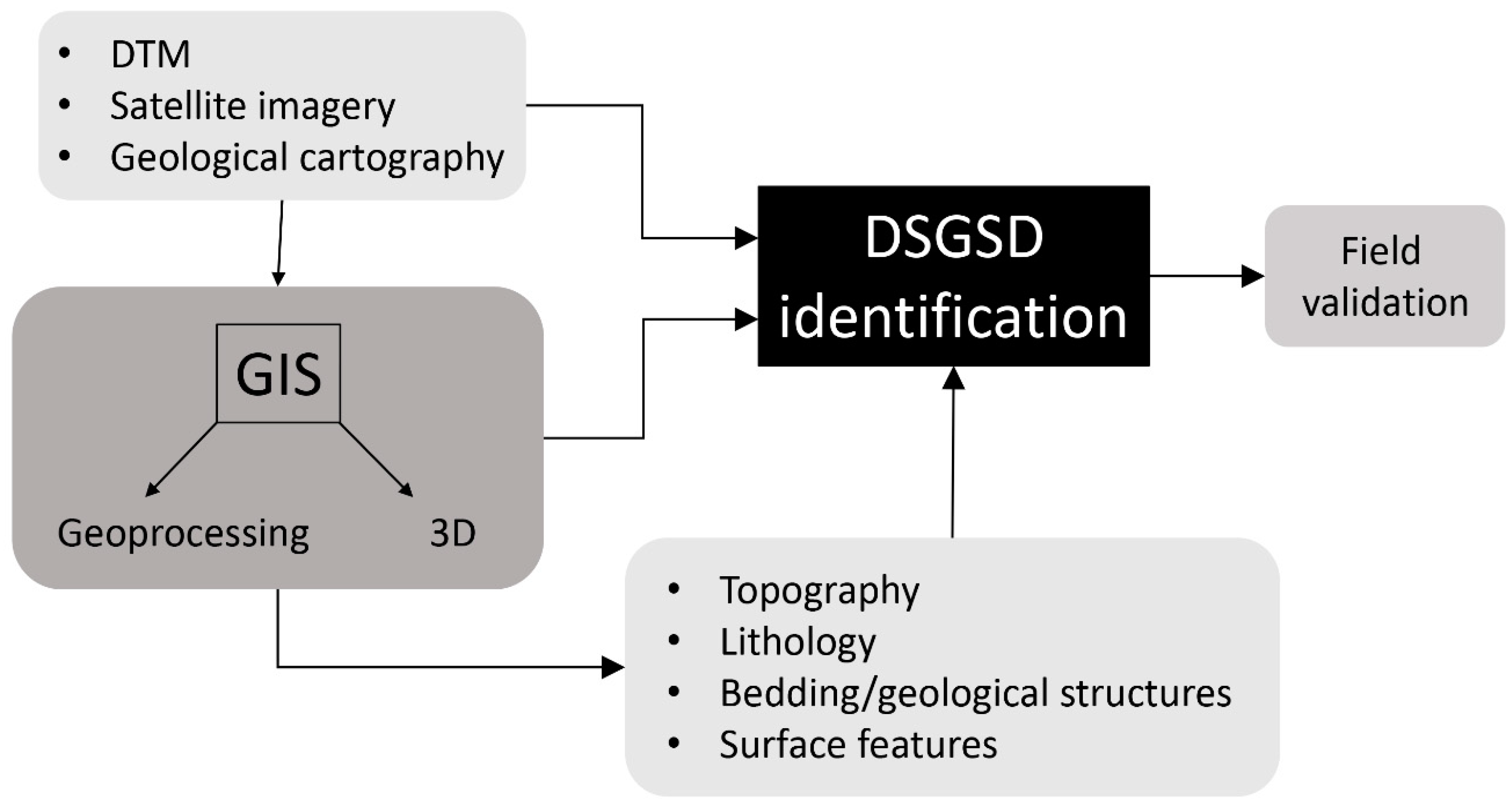
3. Materials and Methods
4. Results
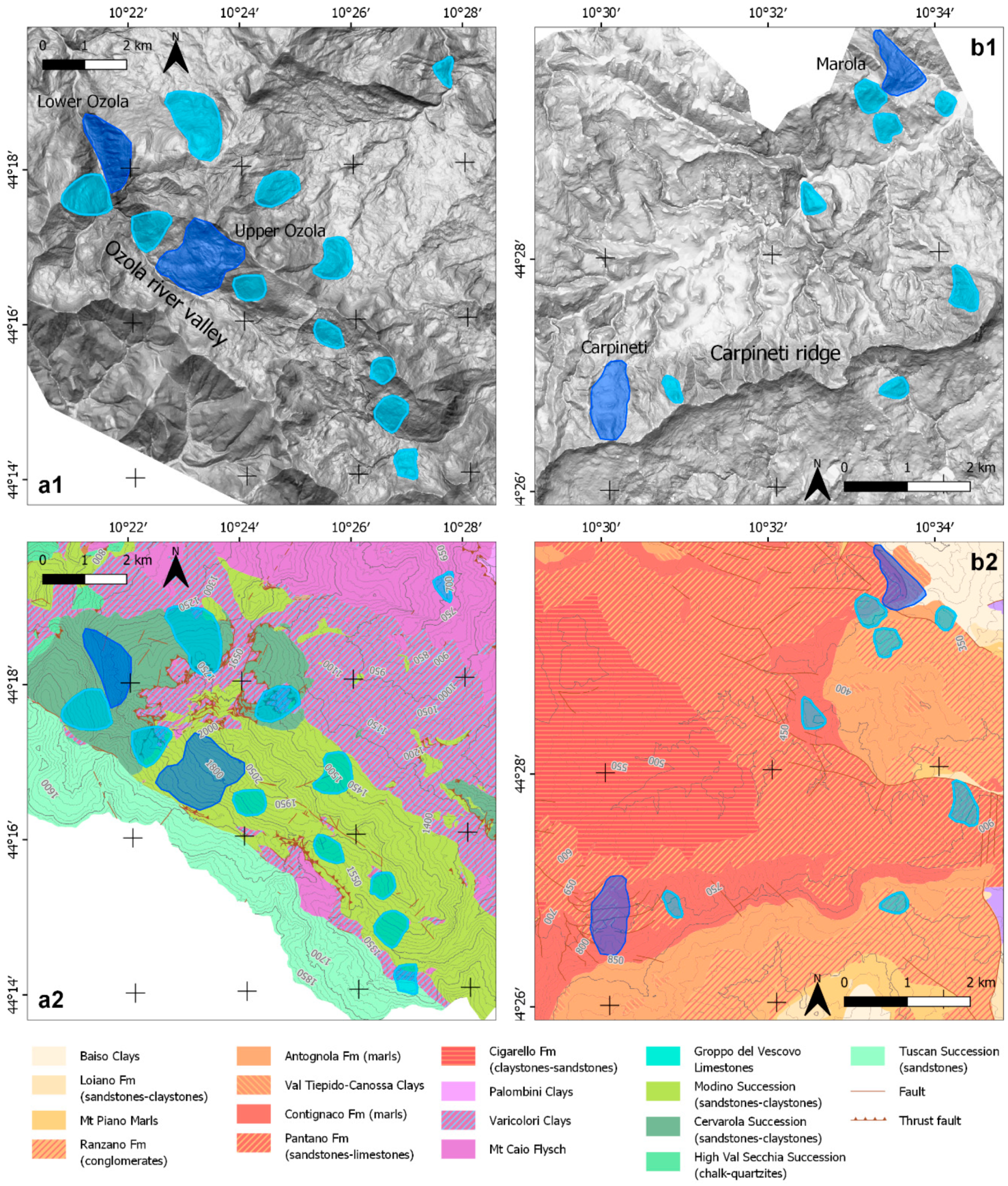
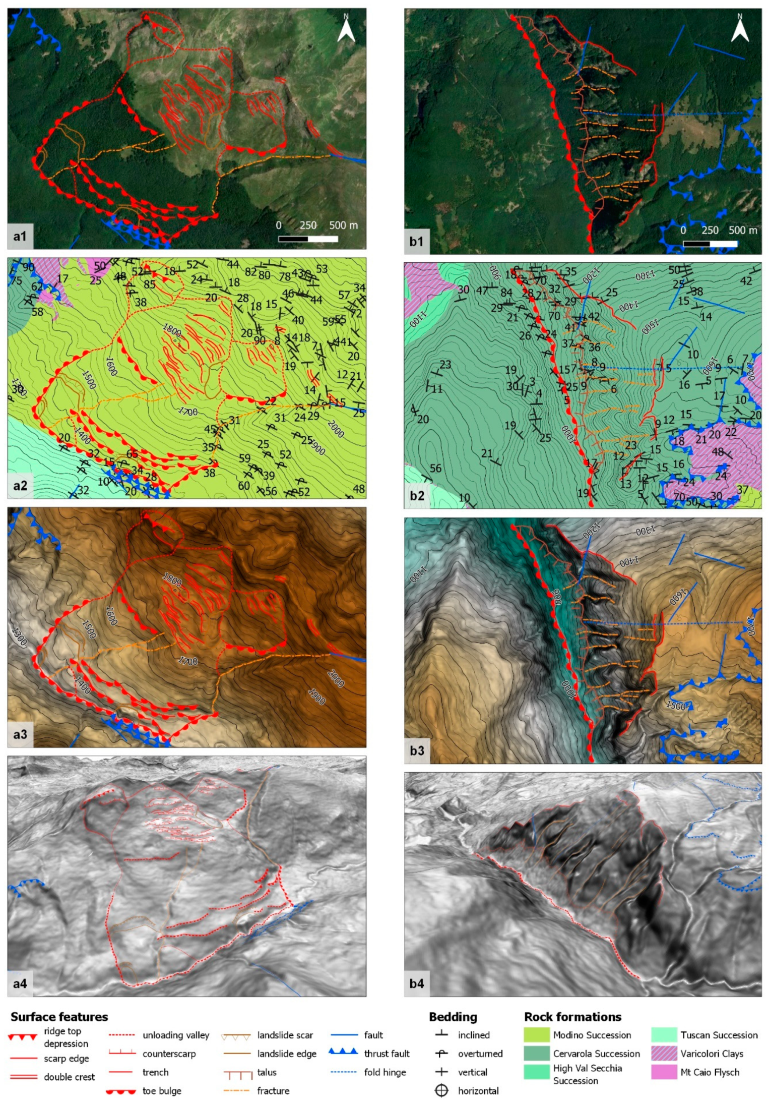
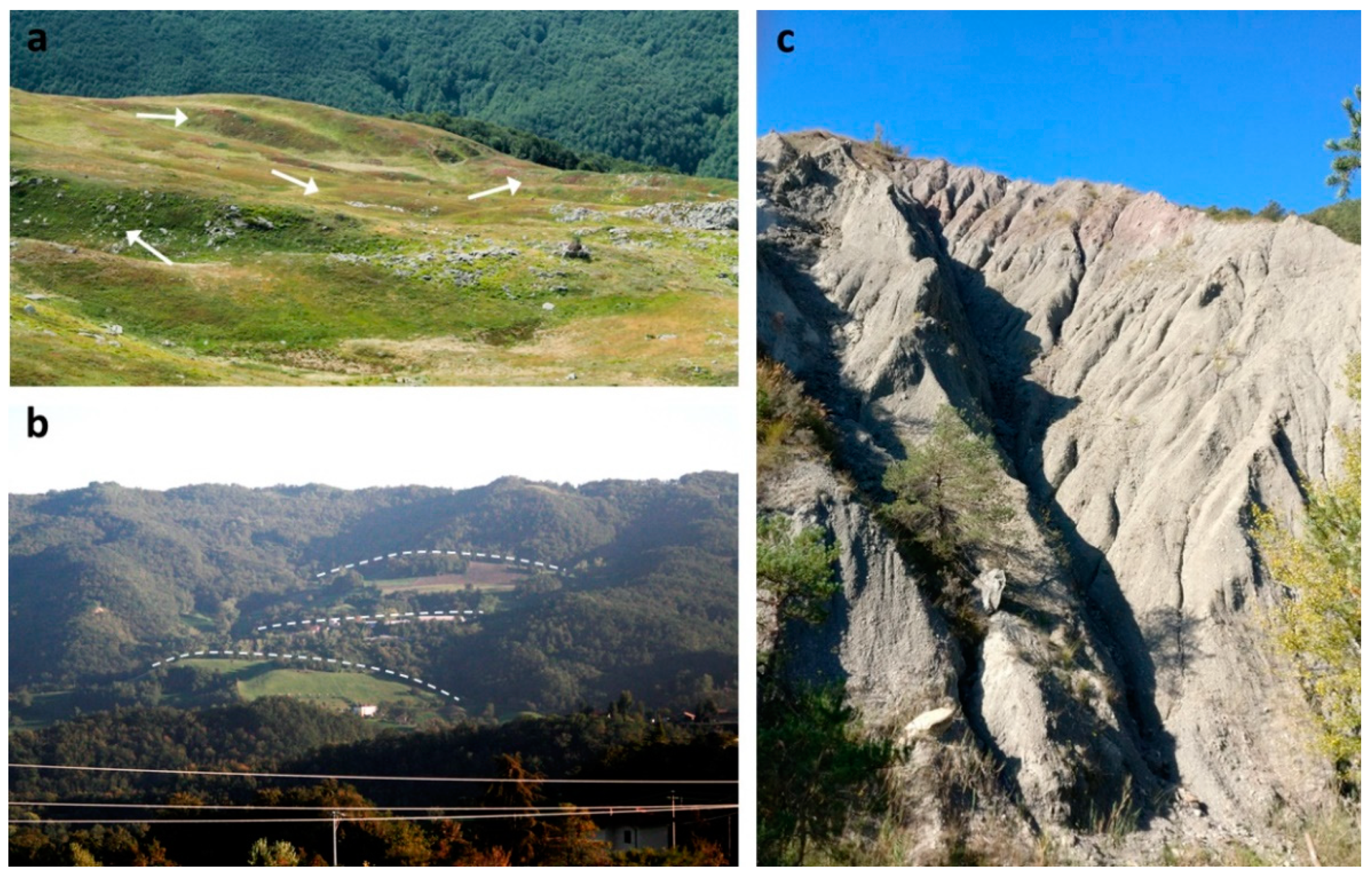
4.1. The Upper Ozola DSGSD
4.2. The Lower Ozola DSGSD
4.3. The Carpineti DSGSD
4.4. The Marola DSGSD
5. Discussion
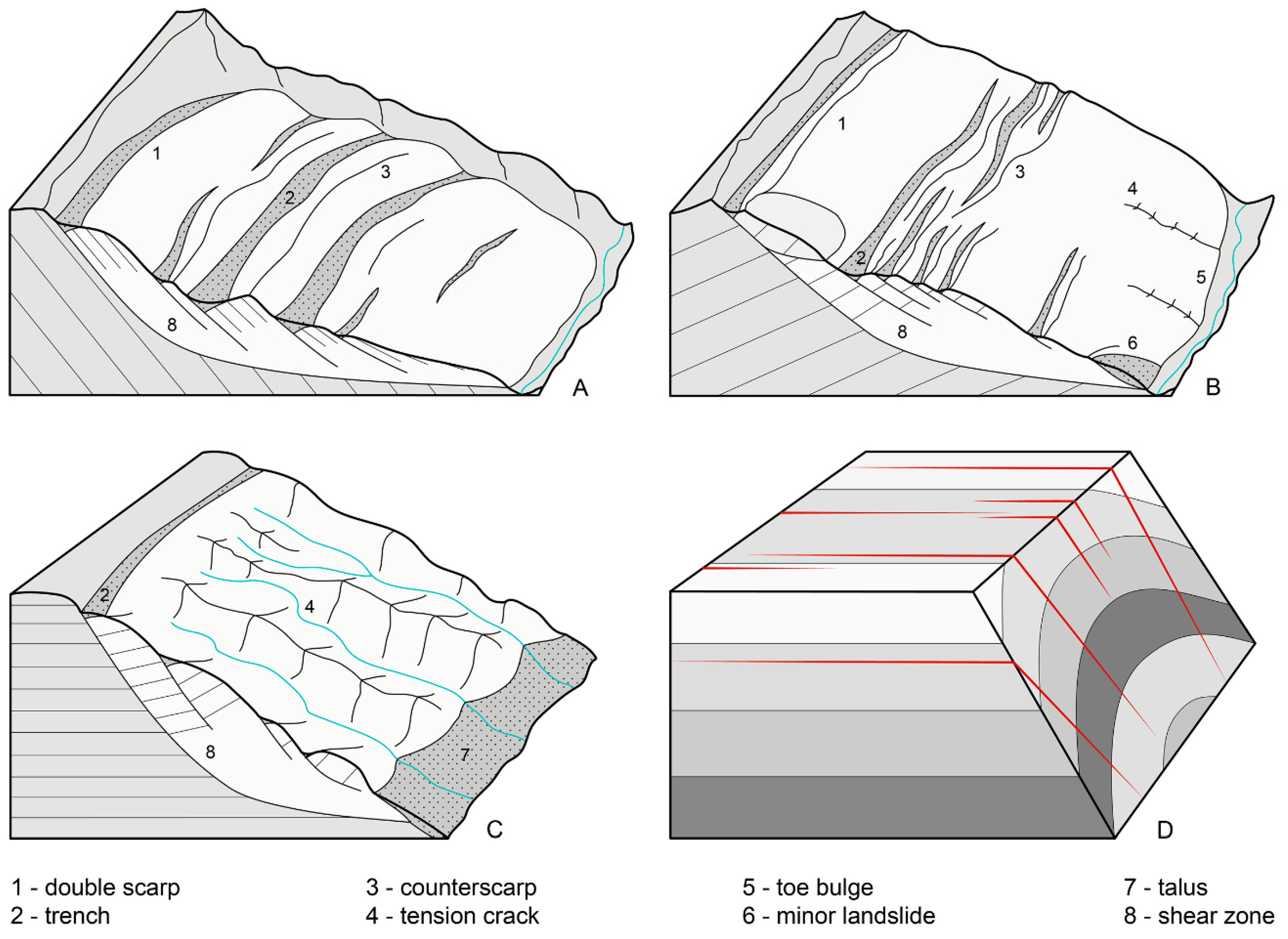
5.1. Geometry and Development of Surface Features
5.2. DSGSD Shape in Relation with Bedding and Folding
6. Conclusions
Author Contributions
Funding
Acknowledgments
Conflicts of Interest
References
- Dramis, F.; Sorriso-Valvo, M. Deep-seated gravitational slope deformations, related landslides and tectonics. Eng. Geol. 1994, 38, 231–243. [Google Scholar] [CrossRef]
- Agliardi, F.; Crosta, G.; Zanchi, A. Structural constraints on deep-seated slope deformation kinematics. Eng. Geol. 2001, 59, 83–102. [Google Scholar] [CrossRef]
- Zischinsky, U. Movement of unstable valley sides. Ges. Geol. Bergbaustud. Mitteil Ungen 1966, 17, 127–168. [Google Scholar]
- Zischinsky, U. Über Sackungen. Rock Mech. 1969, 1, 30–52. [Google Scholar] [CrossRef]
- Nemcok, A. Classification of landslides and other mass movements. Rock Mech. 1972, 4, 71–78. [Google Scholar] [CrossRef]
- Radbruch-hall, D.H. Gravitational Creep of Rock Masses on Slopes. In Developments in Geotechnical Engineering; Voight, B., Ed.; Elsevier: Amsterdam, The Netherlands, 1978; Volume 14, pp. 607–657. [Google Scholar]
- Mahr, T. Deep—Reaching gravitational deformations of high mountain slopes. Bull. Int. Assoc. Eng. Geol. 1977, 16, 121–127. [Google Scholar] [CrossRef]
- McCalpin, J.; Irvine, J.R. Sackungen at the Aspen Highlands Ski Area, Pitkin County, Colorado. Environ. Eng. Geosci. 1995, I, 277–290. [Google Scholar] [CrossRef]
- Bovis, M.J.; Evans, S.G. Extensive deformations of rock slopes in southern Coast Mountains, southwest British Columbia, Canada. Eng. Geol. 1996, 44, 163–182. [Google Scholar] [CrossRef]
- Evans, S.G.; Couture, R. The 1965 Hope Slide, British Columbia; catastrophic failure of a sagging rock slope. In Proceedings of the Geological Society of America Annual Meeting, Denver, CO, USA, 27–30 October 2002. [Google Scholar]
- Soldati, M.; Corsini, A.; Pasuto, A. Landslides and climate change in the Italian Dolomites since the Late glacial. Catena 2004, 55, 141–161. [Google Scholar] [CrossRef]
- Gutiérrez-Santolalla, F.; Acosta, E.; Ríos, S.; Guerrero, J.; Lucha, P. Geomorphology and geochronology of sackung features (uphill-facing scarps) in the Central Spanish Pyrenees. Geomorphology 2005, 69, 298–314. [Google Scholar] [CrossRef]
- Taramelli, A.; Melelli, L. Map of deep seated gravitational slope deformations susceptibility in central Italy derived from SRTM DEM and spectral mixing analysis of the Landsat ETM+ data. Int. J. Remote Sens. 2008, 30, 357–387. [Google Scholar] [CrossRef]
- Audemard, F.; Beck, C.; Carrillo, E. Deep-seated gravitational slope deformations along the active Boconó Fault in the central portion of the Mérida Andes, western Venezuela. Geomorphology 2010, 124, 164–177. [Google Scholar] [CrossRef]
- Ambrosi, C.; Crosta, G.B. Valley shape influence on deformation mechanisms of rock slopes. Geol. Soc. Lond. Spéc. Publ. 2011, 351, 215–233. [Google Scholar] [CrossRef]
- Agliardi, F.; Crosta, G.B.; Frattini, P.; Malusà, M.G. Giant non-catastrophic landslides and the long-term exhumation of the European Alps. Earth Planet. Sci. Lett. 2013, 365, 263–274. [Google Scholar] [CrossRef]
- Chigira, M.; Hariyama, T.; Yamasaki, S. Development of deep-seated gravitational slope deformation on a shale dip-slope: Observations from high-quality drill cores. Tectonophysics 2013, 605, 104–113. [Google Scholar] [CrossRef]
- Crosta, G.; Frattini, P.; Agliardi, F. Deep seated gravitational slope deformations in the European Alps. Tectonophysics 2013, 605, 13–33. [Google Scholar] [CrossRef]
- Coquin, J.; Mercier, D.; Bourgeois, O.; Cossart, E.; Decaulne, A. Gravitational spreading of mountain ridges coeval with Late Weichselian deglaciation: Impact on glacial landscapes in Tröllaskagi, northern Iceland. Quat. Sci. Rev. 2015, 107, 197–213. [Google Scholar] [CrossRef]
- Pánek, T.; Klimeš, J. Temporal behavior of deep-seated gravitational slope deformations: A review. Earth-Sci. Rev. 2016, 156, 14–38. [Google Scholar] [CrossRef]
- Oppikofer, T.; Saintot, A.; Hermanns, R.; Böhme, M.; Scheiber, T.; Gosse, J.; Dreiås, G. From incipient slope instability through slope deformation to catastrophic failure — Different stages of failure development on the Ivasnasen and Vollan rock slopes (western Norway). Geomorphology 2017, 289, 96–116. [Google Scholar] [CrossRef]
- Mariani, G.S.; Cremaschi, M.; Zerboni, A.; Zuccoli, L.; Trombino, L. Geomorphology of the Mt. Cusna Ridge (Northern Apennines, Italy): Evolution of a Holocene landscape. J. Maps 2018, 14, 392–401. [Google Scholar] [CrossRef]
- Frattini, P.; Crosta, G.B.; Rossini, M.; Allievi, J. Activity and kinematic behaviour of deep-seated landslides from PS-InSAR displacement rate measurements. Landslides 2018, 15, 1053–1070. [Google Scholar] [CrossRef]
- Mège, D.; Bourgeois, O. Equatorial glaciations on Mars revealed by gravitational collapse of Valles Marineris wallslopes. Earth Planet. Sci. Lett. 2011, 310, 182–191. [Google Scholar] [CrossRef]
- Kromuszczyńska, O.; Mège, D.; Dębniak, K.; Gurgurewicz, J.; Makowska, M.; Lucas, A. Deep-seated gravitational slope deformation scaling on Mars and Earth: Same fate for different initial conditions and structural evolutions. Earth Surf. Dyn. 2019, 7, 361–376. [Google Scholar] [CrossRef] [Green Version]
- Crosta, G.B.; Frattini, P.; Valbuzzi, E.; De Blasio, F.V. Introducing a New Inventory of Large Martian Landslides. Earth Space Sci. 2018, 5, 89–119. [Google Scholar] [CrossRef]
- Chigira, M. Long-term gravitational deformation of rocks by mass rock creep. Eng. Geol. 1992, 32, 157–184. [Google Scholar] [CrossRef]
- Aringoli, D.; Gentili, B.; Materazzi, M.; Pambianchi, G. Mass movements in Adriatic central Italy: Activation and evolutive control factors. In Landslides: Causes, Types and Effects; Nova Science Publishers, Inc.: New York, NY, USA, 2010. [Google Scholar]
- Crosta, G.B. Landslide, spreading, deep seated gravitational deformation: Analysis, examples, problems and proposals. Geogr. Fis. E Din. Quat. 1996, 19, 297–313. [Google Scholar]
- Ambrosi, C.; Crosta, G. Large sackung along major tectonic features in the Central Italian Alps. Eng. Geol. 2006, 83, 183–200. [Google Scholar] [CrossRef]
- Jomard, H.; Lebourg, T.; Guglielmi, Y. Morphological analysis of deep-seated gravitational slope deformation (DSGSD) in the western part of the Argentera massif. A morpho-tectonic control? Landslides 2013, 11, 107–117. [Google Scholar] [CrossRef]
- McCalpin, J.P. Criteria for determining the seismic significance of sackungen and other scarplike landforms in mountainous regions. In Techniques for Identifying Faults and Determining their Origins; US Nuclear Regulatory Commission: Washington, DC, USA, 1999; pp. 2–55. [Google Scholar]
- Gori, S.; Falcucci, E.; Dramis, F.; Galadini, F.; Galli, P.; Giaccio, B.; Messina, P.; Pizzi, A.; Sposato, A.; Cosentino, D. Deep-seated gravitational slope deformation, large-scale rock failure, and active normal faulting along Mt. Morrone (Sulmona basin, Central Italy): Geomorphological and paleoseismological analyses. Geomorphology 2014, 208, 88–101. [Google Scholar] [CrossRef] [Green Version]
- Aringoli, D.; Gentili, B.; Pambianchi, G.; Piscitelli, A.M. The contribution of the ‘Sibilla Appenninica’ legend to karst knowledge in the Sibillini Mountains (Central Apennines, Italy). Geol. Soc. Lond. Spéc. Publ. 2007, 273, 329–340. [Google Scholar] [CrossRef]
- Martinotti, G.; Giordan, D.; Giardino, M.; Ratto, S. Controlling factors for deep-seated gravitational slope deformation (DSGSD) in the Aosta Valley (NW Alps, Italy). Geol. Soc. Lond. Spéc. Publ. 2011, 351, 113–131. [Google Scholar] [CrossRef]
- Ballantyne, C.K. Paraglacial geomorphology. Quat. Sci. Rev. 2002, 21, 1935–2017. [Google Scholar] [CrossRef]
- Hippolyte, J.-C.; Bourlès, D.; Leanni, L.; Braucher, R.; Chauvet, F.; Lebatard, A. 10Be ages reveal >12ka of gravitational movement in a major sackung of the Western Alps (France). Geomorphology 2012, 171, 139–153. [Google Scholar] [CrossRef]
- Aringoli, D.; Gentili, B.; Materazzi, M.; Pambianchi, G.; Sciarra, N. DSGSDs Induced by Post-Glacial Decompression in Central Apennine (Italy). In Landslide Science and Practice; Springer Science and Business Media: Berlin, Germany, 2013; pp. 417–423. [Google Scholar]
- Pánek, T.; Mentlík, P.; Ditchburn, B.; Zondervan, A.; Norton, K.P.; Hradecký, J. Are sackungen diagnostic features of (de)glaciated mountains? Geomorphology 2015, 248, 396–410. [Google Scholar] [CrossRef]
- Chigira, M.; Tsou, C.-Y.; Matsushi, Y.; Hiraishi, N.; Matsuzawa, M. Topographic precursors and geological structures of deep-seated catastrophic landslides caused by Typhoon Talas. Geomorphology 2013, 201, 479–493. [Google Scholar] [CrossRef]
- Tsou, C.-Y.; Chigira, M.; Matsushi, Y.; Chen, S.-C. Deep-seated gravitational deformation of mountain slopes caused by river incision in the Central Range, Taiwan: Spatial distribution and geological characteristics. Eng. Geol. 2015, 196, 126–138. [Google Scholar] [CrossRef]
- Kinakin, D.; Stead, D. Analysis of the distributions of stress in natural ridge forms: Implications for the deformation mechanisms of rock slopes and the formation of sackung. Geomorphology 2005, 65, 85–100. [Google Scholar] [CrossRef]
- Hippolyte, J.-C.; Brocard, G.; Tardy, M.; Nicoud, G.; Bourlès, D.; Braucher, R.; Menard, G.; Souffaché, B. The recent fault scarps of the Western Alps (France): Tectonic surface ruptures or gravitational sackung scarps? A combined mapping, geomorphic, levelling, and 10Be dating approach. Tectonophysics 2006, 418, 255–276. [Google Scholar] [CrossRef]
- Agliardi, F.; Zanchi, A.; Crosta, G.B. Tectonic vs. gravitational morphostructures in the central Eastern Alps (Italy): Constraints on the recent evolution of the mountain range. Tectonophysics 2009, 474, 250–270. [Google Scholar] [CrossRef]
- Jibson, R.W.; Harp, E.L.; Schulz, W.; Keefer, D.K. Landslides Triggered by the 2002 Denali Fault, Alaska, Earthquake and the Inferred Nature of the Strong Shaking. Earthq. Spectra 2004, 20, 669–691. [Google Scholar] [CrossRef]
- Moro, M.; Saroli, M.; Salvi, S.; Stramondo, S.; Doumaz, F. The relationship between seismic deformation and deep-seated gravitational movements during the 1997 Umbria–Marche (Central Italy) earthquakes. Geomorphology 2007, 89, 297–307. [Google Scholar] [CrossRef]
- Chigira, M.; Kiho, K. Deep-seated rockslide-avalanches preceded by mass rock creep of sedimentary rocks in the Akaishi Mountains, central Japan. Eng. Geol. 1994, 38, 221–230. [Google Scholar] [CrossRef]
- Crosta, G.; Chen, H.; Frattini, P. Forecasting hazard scenarios and implications for the evaluation of countermeasure efficiency for large debris avalanches. Eng. Geol. 2006, 83, 236–253. [Google Scholar] [CrossRef]
- Chigira, M. September 2005 rain-induced catastrophic rockslides on slopes affected by deep-seated gravitational deformations, Kyushu, southern Japan. Eng. Geol. 2009, 108, 1–15. [Google Scholar] [CrossRef]
- Moro, M.; Saroli, M.; Gori, S.; Falcucci, E.; Galadini, F.; Messina, P. The interaction between active normal faulting and large scale gravitational mass movements revealed by paleoseismological techniques: A case study from central Italy. Geomorphology 2012, 151, 164–174. [Google Scholar] [CrossRef]
- Pedrazzini, A.; Jaboyedoff, M.; Loye, A.; Derron, M.-H. From deep seated slope deformation to rock avalanche: Destabilization and transportation models of the Sierre landslide (Switzerland). Tectonophysics 2013, 605, 149–168. [Google Scholar] [CrossRef]
- Zangerl, C.; Eberhardt, E.; Perzlmaier, S. Kinematic behaviour and velocity characteristics of a complex deep-seated crystalline rockslide system in relation to its interaction with a dam reservoir. Eng. Geol. 2010, 112, 53–67. [Google Scholar] [CrossRef]
- Paronuzzi, P.; Rigo, E.; Bolla, A. Influence of filling–drawdown cycles of the Vajont reservoir on Mt. Toc slope stability. Geomorphology 2013, 191, 75–93. [Google Scholar] [CrossRef]
- Stead, D.; Wolter, A. A critical review of rock slope failure mechanisms: The importance of structural geology. J. Struct. Geol. 2015, 74, 1–23. [Google Scholar] [CrossRef]
- Varnes, D.J. Slope movement types and processes. In Landslides, Analysis and Control; Special Report; Transportation and Road Research Board, Natural Academy of Sciences: Washington, DC, USA, 1978; pp. 11–33. [Google Scholar]
- Guzzetti, F.; Cardinali, M.; Reichenbach, P. The Influence of Structural Setting and Lithology on Landslide Type and Pattern. Environ. Eng. Geosci. 1996, II, 531–555. [Google Scholar] [CrossRef]
- Břežný, M.; Pánek, T.; Lenart, J.; Grygar, R.; Tábořík, P.; McColl, S.T. Sackung and enigmatic mass movement folds on a structurally-controlled mountain ridge. Geomorphology 2018, 322, 175–187. [Google Scholar] [CrossRef]
- Massironi, M.; Genevois, R.; Floris, M.; Stefani, M. Influence of the antiformal setting on the kinematics of a large mass movement: The Passo Vallaccia, eastern Italian Alps. Bull. Int. Assoc. Eng. Geol. 2010, 70, 497–506. [Google Scholar] [CrossRef]
- Bistacchi, A.; Massironi, M.; Superchi, L.; Zorzi, L.; Francese, R.; Giorgi, M.; Chistolini, F.; Genevois, R. A 3D geological model of the 1963 Vajont landslide. Ital. J. Eng. Geol. Environ. 2013, 6, 531–539. [Google Scholar]
- Hou, Y.; Chigira, M.; Tsou, C.-Y. Numerical study on deep-seated gravitational slope deformation in a shale-dominated dip slope due to river incision. Eng. Geol. 2014, 179, 59–75. [Google Scholar] [CrossRef]
- Chalupa, V.; Pánek, T.; Tábořík, P.; Klimeš, J.; Hartvich, F.; Grygar, R. Deep-seated gravitational slope deformations controlled by the structure of flysch nappe outliers: Insights from large-scale electrical resistivity tomography survey and LiDAR mapping. Geomorphology 2018, 321, 174–187. [Google Scholar] [CrossRef]
- Aringoli, D.; Gentili, B.; Materazzi, M.; Pambianchi, G. Deep-seated gravitational slope deformations in active tectonics areas of the Umbria-Marche Apennine (Central Italy). Geogr. Fis. Dinam. Quat. 2010, 33, 127–140. [Google Scholar]
- Aringoli, D.; Gentili, B.; Pambianchi, G. The role of recent tectonics in controlling the deep-seated gravitational deformation of Mount Frascare (central Apennines). Geogr. Fis. Dinam. Quat. 1996, 19, 281–286. [Google Scholar]
- Trigila, A.; Iadanza, C. Landslides in Italy; Italian National Institute for Environmental Protection and Research (ISPRA): Roma, Italy, 2008. [Google Scholar]
- Vai, F.; Martini, I.P. Anatomy of an Orogen: The Apennines and Adjacent Mediterranean Basins; Springer: Berlin, Germany, 2013. [Google Scholar]
- Bosellini, A. Storia Geologica d’Italia: Gli ultimi 200 milioni di anni; Zanichelli: Bologna, Italy, 2005. [Google Scholar]
- Zoetemeijer, R.; Sassi, W.; Roure, F.; Cloetingh, S. Stratigraphic and kinematic modeling of thrust evolution, northern Apennines, Italy. Geology 1992, 20, 1035. [Google Scholar] [CrossRef] [Green Version]
- Finetti, I.; Boccaletti, M.; Bonini, M.; Del Ben, A.; Geletti, R.; Pipan, M.; Sani, F. Crustal section based on CROP seismic data across the North Tyrrhenian–Northern Apennines–Adriatic Sea. Tectonophysics 2001, 343, 135–163. [Google Scholar] [CrossRef]
- Pini, G.A. Tectonosomes and Olistostromes in the Argille Scagliose of the Northern Apennines, Italy; Geological Society of America: Boulder, CO, USA, 1999; Volume 335. [Google Scholar]
- Livani, M.; Scrocca, D.; Arecco, P.; Doglioni, C. Structural and Stratigraphic Control on Salient and Recess Development Along a Thrust Belt Front: The Northern Apennines (Po Plain, Italy). J. Geophys. Res. Solid Earth 2018, 123, 4360–4387. [Google Scholar] [CrossRef]
- Gelati, R. Storia geologica del paese Italia; Diabasis: Parma, Italy, 2013. [Google Scholar]
- Pellegrini, L.; Vercesi, P.L. Landscapes and Landforms Driven by Geological Structures in the Northwestern Apennines. In World Geomorphological Landscapes; Springer Science and Business Media: Berlin, Germany, 2017; pp. 203–213. [Google Scholar]
- Bertolini, G.; Corsini, A.; Tellini, C. Fingerprints of Large-Scale Landslides in the Landscape of the Emilia Apennines. In World Geomorphological Landscapes; Springer Science and Business Media: Berlin, Germany, 2017; pp. 215–224. [Google Scholar]
- Bertolini, G.; Canuti, P.; Casagli, N.; De Nardo, M.T.; Egidi, D.; Mainetti, M.; Pignone, R.; Pizziolo, M. Carta della Pericolosita Relativa da Frana della Regione Emilia-Romagna; SystemCart: Rome, Italy, 2002. [Google Scholar]
- Regione Emilia-Romagna Carta Inventario delle frane e Archivio storico delle frane. Available online: https://ambiente.regione.emilia-romagna.it/it/geologia/cartografia/webgis-banchedati/cartografia-dissesto-idrogeologico (accessed on 29 June 2020).
- Carlini, M.; Chelli, A.; Vescovi, P.; Artoni, A.; Clemenzi, L.; Tellini, C.; Torelli, L. Tectonic control on the development and distribution of large landslides in the Northern Apennines (Italy). Geomorphology 2016, 253, 425–437. [Google Scholar] [CrossRef]
- Bertolini, G. Radiocarbon Dating on Landslides in the Northern Apennines (Italy). In Landslides and Climate Change: Challenges and Solutions; Mathie, E., McInnes, R., Fairbank, H., Jakeways, J., Eds.; Taylor & Francis: London, UK, 2007; pp. 73–80. [Google Scholar]
- Bertolini, G.; Tellini, C. New radiocarbon dating for landslide occurrences in the Emilia Apennines (Northern Italy). Trans. Jpn. Geomorphol. Union 2001, 22, C-23. [Google Scholar]
- Compostella, C.; Mariani, G.S.; Trombino, L. Holocene environmental history at the treeline in the Northern Apennines, Italy: A micromorphological approach. Holocene 2014, 24, 393–404. [Google Scholar] [CrossRef]
- Bertolini, G.; Pellegrini, M. The landslides of Emilia Apennines (northern Italy) with reference to those which resumed activity in the 1994–1999 period and required Civil Protection interventions. Quad. Geol. 2001, 8, 27–74. [Google Scholar]
- Mariani, G.S.; Brandolini, F.; Pelfini, M.; Zerboni, A. Matilda’s castles, northern Apennines: Geological and geomorphological constrains. J. Maps 2019, 15, 521–529. [Google Scholar] [CrossRef]
- Mariani, G.S.; Compostella, C.; Trombino, L. Complex climate-induced changes in soil development as markers for the Little Ice Age in the Northern Apennines (Italy). Catena 2019, 181, 104074. [Google Scholar] [CrossRef]
- Losacco, U. La glaciazione quaternaria dell’Appennino settentrionale. Riv. Geogr. Ital. 1949, 56, 90–152. [Google Scholar]
- Losacco, U. Gli antichi ghiacciai dell’Appenino settentrionale: Studio morfologico e paleogeografico. Atti Soc. Nat. Mat. Modena 1982, 113, 1–24. [Google Scholar]
- Morelli, S.; Pazzi, V.; Frodella, W.; Fanti, R. Kinematic Reconstruction of a Deep-Seated Gravitational Slope Deformation by Geomorphic Analyses. Geosciences 2018, 8, 26. [Google Scholar] [CrossRef] [Green Version]
- Regione Emilia-Romagna Cartografia di Base. Available online: https://geoportale.regione.emilia-romagna.it/catalogo/dati-cartografici/cartografia-di-base (accessed on 29 June 2020).
- Regione Emilia-Romagna Banca Dati Geologica, 1:10.000. Available online: https://geoportale.regione.emilia-romagna.it/catalogo/dati-cartografici/informazioni-geoscientifiche/geologia/banca-dati-geologica-1-10.000 (accessed on 29 June 2020).
- Jaboyedoff, M.; Penna, I.; Pedrazzini, A.; Baroň, I.; Crosta, G.B. An introductory review on gravitational-deformation induced structures, fabrics and modeling. Tectonophysics 2013, 605, 1–12. [Google Scholar] [CrossRef]
- Papani, G.; De Nardo, M.T.; Bettelli, G.; Rio, D.; Tellini, C.; Vernia, L. Note Illustrative della Carta Geologica d’Italia alla Scala 1:50.000, Foglio 218 Castelnuovo ne’ Monti; Servizio Geologico d’Italia: Regione Emilia Romagna, Italy, 2002. [Google Scholar]
- Savage, W.Z.; Varnes, D.J. Mechanics of gravitational spreading of steep-sided ridges («sackung»). Bull. Int. Assoc. Eng. Geol. 1987, 35, 31–36. [Google Scholar] [CrossRef]
- Carobene, L.; Cevasco, A. A large scale lateral spreading, its genesis and Quaternary evolution in the coastal sector between Cogoleto and Varazze (Liguria—Italy). Geomorphology 2011, 129, 398–411. [Google Scholar] [CrossRef]
- Baker, V.R. Planetary landscape systems: A limitless frontier. Earth Surf. Process. Landf. 2008, 33, 1341–1353. [Google Scholar] [CrossRef]
- Baker, V.R. The modern evolution of geomorphology—Binghamton and personal perspectives, 1970–2019 and beyond. Geomorphology 2019, 106684. [Google Scholar] [CrossRef]


| DSGSD | Lithostructure | Strike-Parallel | Surface Features Dip-Parallel | Complex |
|---|---|---|---|---|
| Low Ozola | Fold hinge | Counterscarp | Vertical fractures | Toe bulge |
| scarp edge | ||||
| High Ozola | Anaclinal slope | Counterscarp | Tension cracks | Toe bulge |
| double crest | Unloading valley | |||
| landslide edge | ||||
| landslide scar | ||||
| ridge top depression | ||||
| scarp head | ||||
| trench | ||||
| Carpineti | Cataclinal slope | Counterscarp | Unloading valley | |
| landslide scar | ||||
| ridge top depression | ||||
| trench | ||||
| Marola | Anaclinal slope | Unloading valley | Tension cracks | Toe bulge |
| landslide scar | ||||
| landslide edge | ||||
| ridge top depression |
© 2020 by the authors. Licensee MDPI, Basel, Switzerland. This article is an open access article distributed under the terms and conditions of the Creative Commons Attribution (CC BY) license (http://creativecommons.org/licenses/by/4.0/).
Share and Cite
Mariani, G.S.; Zerboni, A. Surface Geomorphological Features of Deep-Seated Gravitational Slope Deformations: A Look to the Role of Lithostructure (N Apennines, Italy). Geosciences 2020, 10, 334. https://0-doi-org.brum.beds.ac.uk/10.3390/geosciences10090334
Mariani GS, Zerboni A. Surface Geomorphological Features of Deep-Seated Gravitational Slope Deformations: A Look to the Role of Lithostructure (N Apennines, Italy). Geosciences. 2020; 10(9):334. https://0-doi-org.brum.beds.ac.uk/10.3390/geosciences10090334
Chicago/Turabian StyleMariani, Guido S., and Andrea Zerboni. 2020. "Surface Geomorphological Features of Deep-Seated Gravitational Slope Deformations: A Look to the Role of Lithostructure (N Apennines, Italy)" Geosciences 10, no. 9: 334. https://0-doi-org.brum.beds.ac.uk/10.3390/geosciences10090334