Rockfall Research: A Bibliometric Analysis and Future Trends
by
 , , and
Josué Briones-Bitar
1,2,* ,
,
Paúl Carrión-Mero
1,2,*,
Néstor Montalván-Burbano
2,3 and
and
Fernando Morante-Carballo
2,4,5 1
Facultad de Ingeniería en Ciencias de la Tierra (FICT), ESPOL Polytechnic University, Campus Gustavo Galindo Km 30.5 via Perimetral, 09-01-5863 Guayaquil, Ecuador
2
Centro de Investigación y Proyectos Aplicados a las Ciencias de la Tierra (CIPAT), ESPOL Polytechnic University, Campus Gustavo Galindo Km 30.5 via Perimetral, 09-01-5863 Guayaquil, Ecuador
3
Management and Business Department, University of Almería, Ctra. Sacramento s/n, La Cañada de San Urbano, 04120 Almería, Spain
4
Facultad de Ciencias Naturales y Matemáticas (FCNM), ESPOL Polytechnic University, Campus Gustavo Galindo Km. 30.5 Vía Perimetral, 09-01-5863 Guayaquil, Ecuador
5
Geo-recursos y Aplicaciones (GIGA), ESPOL Polytechnic University, Campus Gustavo Galindo Km. 30.5 Vía Perimetral, 09-01-5863 Guayaquil, Ecuador
*
Authors to whom correspondence should be addressed.
Geosciences 2020, 10(10), 403; https://0-doi-org.brum.beds.ac.uk/10.3390/geosciences10100403
Submission received: 21 August 2020
/
Revised: 27 September 2020
/
Accepted: 30 September 2020
/
Published: 9 October 2020
(This article belongs to the Special Issue Rock Fall Hazard and Risk Assessment)
Abstract
:Rockfall is one of the main phenomena in mountainous environments due to its fast and high speed of movement, its unpredictability, and, therefore, the difficulty of identifying signs of instability and detachment of the blocks. Compared to other types of sliding, the proportion of rockfall research is smaller and sometimes little known, but, in the last five years, rapid growth in this area has been shown. Therefore, this research aimed to review the intellectual structure of rockfall, through analysis of scientific production using bibliometric techniques that allow its analysis, knowledge, global evolution, and future trends in rockfall. The research methodology consists of three steps: (1) data compilation, (2) software and data cleaning, and (3) analysis, interpretation, and visualization. This analysis focuses on the period from 1975 to 2019. For the data, a total of 811 academic publications were retrieved from the Scopus database. The results indicate an increasing trend of annual publications on rockfall. This analysis reveals the main topics, countries, and most influential institutions in the world that have carried out relevant research in scientific publications; it also shows the journals that have the most publications. VOSviewer software was adopted to evaluate the co-occurrence of author keywords. Currently, the hotspots rockfall issues mainly include: hazard-risk assessment, remote sensing, and rockfall monitoring. Finally, this article analyzes the limitations of current research and proposes a future direction for the development of new research.
1. Introduction
Rockfall is the most frequent natural event in mountainous areas. Rockfalls are classified as a type of landslide that consists of the detachment of a rock block (or several individual rocks) from a vertical or sub-vertical cliff followed by rapid down-slope motion characterized by free-falling, bouncing, rolling, and sliding phases [1,2]. Cruden [3] and Zabota [4] complement this definition by stating that a rockfall is a fragmented rock or block that has detached from a surface slope or cliff by falling, sliding, toppling, bouncing, or rolling. Rockfall, commonly, is a relatively small limited sliding to the removal of individual and surface rocks from a cliff [5,6]. Rockfall can generate massive large-scale movements of solid material, but these processes are defined as rockfall or rock avalanches [3,7,8]. A common approach to explaining rockfall is to analyze the environmental conditions that promote the occurrence of rocks and those factors that initiate movement [9,10]. Detachment mechanisms include natural climatic conditions, such as freeze-thaw [11], lithology, morphology [12], slope gradient [13], faults, and seismic activities [14,15].
Compared to other types of landslides, the proportion of rockfall research is small [2,16]. However, driven by the demand for civil works construction in mountainous areas, rockfall research is increasingly attracting the attention of academics and researchers [17,18]. Rockfall not only threatens the environment but also generates a severe loss of life within its area of influence because it behaves suddenly, frequently, and randomly [19,20,21]. Every year, blocks ranging from a few kilograms to tens of tons cause traffic interruptions, damage to structures and vehicles, and sometimes fatalities [22]. These natural disasters have been a subject of intensive research due to their significant destructive power: (i) Gotthard Tunnel in Switzerland: on 31 May 2006, a major rockfall (5000 m3) killed two tourists on the main highway crossing the Alps through the Gotthard Tunnel [23], and (ii) ski resort Whistler, Vancouver, Canada: during the night of 29 July 2008, a rockfall blocked the highway Sea to Sky joining Vancouver to the ski resort Whistler [24].
Protecting people and infrastructure against rockfall phenomena is one of the most challenging tasks [25,26,27]. For this purpose, risk assessment procedures play a crucial role [20,28,29,30,31]. Therefore, rockfall-related studies are of great importance to prevent and reduce risk and to improve disaster mitigation and preparedness capabilities. During the past four decades, numerous studies have elucidated the various perspectives of rockfall hazards. In the scientific literature for evaluating hazard and risk from falling rocks, various qualitative and quantitative approaches have been proposed (e.g., References [32,33,34,35,36,37]). The choice between qualitative and quantitative hazard methodology is strictly related to the available dataset and does not depend on the complexity of the methods that are used to define the hazard [38]. Due to qualitative methods are based on the qualitative classification of the attributes of the rock surface, quantitative approaches require a significant amount of site-specific data [39,40].
For the protection and prevention of risks that a rockfall can cause are the construction of specialized structures or the maintenance and creation of green areas, for example, by building capture or barrier fences and containment networks [41], but these measures are expensive and deteriorate over time [42]. In some cases, maintaining forest stands with an explicit protection function, or a protection forest is profitable and more sustainable [43,44]. Therefore, studies related to rockfalls are of great importance to prevent and reduce risk and to improve disaster mitigation and preparedness capabilities.
The monitoring and early warning of rockfall hazards in mountainous areas are also necessary. Commonly used technologies of rockfall monitoring include light detection and ranging (LiDAR), laser scanning, geographical information systems (GISs), and video image recognition [45,46]. In addition, researchers usually combine LiDAR, laser scanning, and GIS technology to establish a three-dimensional numerical model of a rockfall and to analyze the spatiotemporal characteristics of rockfall hazards [47,48,49].
Over the past four decades, some researchers have submitted revisions and diverse perspectives of the risks of rockfalls in geo-environmental and geosciences science. Dorren [9] summarized existing rockfall models and proposed modifications to make them suitable for predicting rockfall on a regional scale; Volkwein et al. [50] and Ferrari et al. [39] provided an overview of both rockfall modeling, as well as hazard zoning and protective measures. These investigations have provided valuable information within the topic; therefore, it is necessary to carry out a systematic review, as well as bibliometric analysis for the integration of all the studies carried out.
The corresponding research results have been published by authors from all over the world in a large number of journals. To summarize global rockfall research trends and provide a potential guide for future research, a bibliometric analysis was applied to rockfall-related articles from Scopus databases during the period 1975–2019. This will allow us to integrate knowledge, understanding the evolution and trends in a field of research. On this, we pose the following question: Is it possible to evaluate the evolution and trends related to research on the Rockfall theme through bibliometric analysis that allows a better understanding of the topic and that serves as a guide for future research?
Given these antecedents and what is stated in the research question, the scientific work aimed to review the intellectual structure of Rockfall, through analysis of scientific production using bibliometric techniques that allow its analysis, knowledge, its global evolution, and future trend lines about Rockfall. In this research work, three sections are presented: (i) Literary review on the subject and explanation of the methodology used, (ii) presentation of quantitative and qualitative results on the scientific production on Rockfall, and (iii) bibliometric analysis of the results, their discussion, conclusion and presentation of future research trends.
2. Materials and Methods
The literature review is an essential contribution to research progress by providing a systematic procedure that seeks to minimize potential biases and errors when selecting studies in a given area of knowledge, as well as an in-depth description of independent research efforts to identify potential gaps and highlight the limits of knowledge [51,52,53]. In this regard, Rowley and Slack [54] recommend a comprehensive methodology to structure a literature review, where bibliometric analyzes contemplate a similar systematic process [55].
Bibliometric studies consider a scientific field that uses quantitative analysis to describe, evaluate, and monitor scientific publications in a field of science and identify its main trends [56,57,58], allowing the analysis of the structure of a scientific research field [59,60]. This type of analysis was introduced in the academy by Eugene Garfield in the mid-20th century [61], and today it has spread in various academic fields, such as management [62], environment [63], and Earth Sciences. This last field has allowed the study of some disciplines, such as seismology [64], marine hazards [65], hydrogeology [66], landslides [67,68], remote sensing [69], oil industry [70], and geotourism [71], among others. In bibliometric analysis, a topic called bibliometric mapping is presented, which allows a visual understanding of the structure and behavior of the scientific field by observing the connections in its structure represented by units of analysis, such as documents, countries, or authors [72].
The proposed methodology for this bibliometric study is structured and comprises three phases: (1) Data compilation, (2) software and data cleaning, and (3) analysis, interpretation and visualization; to identify the most influential studies, in order to determine the thematic areas of research and provide information on current research interests. A summary of the application of the methodology shown in Figure 1.
2.1. Data Compilation
In bibliometric studies, the first step is the selection of an adequate and reliable database that allows the analysis to be carried out [73]. Currently, there is a debate on the comparability and stability of the statistical data obtained according to the two primary databases: Web of Science (WoS) and Scopus [74]. For this analysis, we chose the Scopus scientific database, which belongs to Elsevier, for our bibliometric analysis [75]. According to Elsevier, Scopus is the largest database of citations and summaries of peer-reviewed literature that has been used by various researchers for bibliometric analysis in various areas of research [76,77]. Scopus is a multidisciplinary database that has more than 69 million records; also, it has more indexed journals than the WoS [78,79].
The next step is the choice of the search parameter, which consists of a guide that avoids extensive results, which opens the door to literature that is not related to the area of knowledge and too limited results that leave out the scientific literature. important in the field [56,80,81]. In this investigation, the documents were considered relevant, in which our search argument appears only in the title [82,83,84]. The search argument is: (TITLE (“Rock-fall*”) OR TITLE (“Rockfall*”)), search carried out in April 2020, obtaining 1590 documents.
The study source was limited to the analysis of only published articles, which guarantees the academic quality of the publications and the homogenization of the results [85]. Indexed journals ensure academic quality, which is backed by a blind peer review [86]. With this search parameter, publications are obtained between 1942 and 2020; with the latter being this year, we exclude it because the totality of documents would not be available.
Finally, we considered an additional parameter related to language, in that only those written in English were analyzed because this language dominates scientific production in most scientific areas and is one of the most used restrictions in articles that use the bibliometric analysis [87,88]. With this last limitation, the final search argument was as follows: (TITLE (“Rock-fall*”) OR TITLE (“Rockfall*”)) AND (LIMIT-TO (DOCTYPE, “ar”)) AND (EXCLUDE (PUBYEAR, 2020)) AND (LIMIT-TO (LANGUAGE, “English”)).
2.2. Software and Data Cleaning
The obtained information was exported to an Excel spreadsheet for analysis and organization [68,89]. Our database had a variety of parameters, in which the following are highlighted: the author’s details (name/s and affiliation/s), the title of the article, the title of the journal, keywords used, the abstract, and the dating count. The reference collection needed to be reviewed and debugged by making the following adjustments: (i) delete records without an author, (ii) delete duplicate files, and (iii) delete error records. We reviewed the database, and only the first adjustment reported inconsistency in an article; therefore, our database was reduced to 814 scientific articles.
2.3. Analysis, Interpretation and Visualization
Among the most widely used, leading and educational free access software based on its excellent results and data processing, we have the VOSviewer [90]. VOSviewer software is a tool popularly used in bibliometric literature and its analysis in different areas of knowledge [62,91,92,93]. This software was developed for the construction and visualization of bibliometric maps, which show the structure and networks of authors, magazines, universities, and countries [94]. VOSviewer is used to build author or journal maps based on co-citation data or to make keyword maps based on co-occurrence data [95,96].
3. Results
This section has been divided into two parts. In the first, scientific production based on its performance is evaluated. This allows us to examine the journals and subject areas that have been presented, as well as the contribution of the countries and institutions that have promoted the research and their authors. In the second part, the intellectual structure of Rockfall is analyzed by considering its evolution using bibliometric network maps based on author keywords.
3.1. Scientific Production Analysis
3.1.1. Scientific Production Period
Examining the chosen period (1942–2019), significant gaps were observed between years; for example, between 1943–1964, there are no documents on this subject, as well as the periods 1966–1968 and 1970–1974. Between the period 1942–1974, there are only three documents: (i) in 1942 titled Coal mine rock falls [97], (ii) in 1965 titled Rockfall-avalanche and rockslide-avalanche deposits at Sawtooth Ridge, Montana [98], and (iii) in 1969 titled Determination of the statistical characteristics of rock falls on the periphery of an unsupported underground working [99]. Therefore, our research period was between 1975–2019.
Therefore, a total of 811 publications meet all the criteria and are analyzed. The first publication in this period was recorded in 1975 and titled Surge effects in a lake as a consequence of rockfalls. Model tests to predict the effects of avalanches of rock on the Walensee [100]; and the latest publication was titled Economic valuation of ecosystem-based rockfall risk reduction considering disturbances and comparison to structural measures [101].
Figure 2 shows the number of scientific publications per year, from 1975 to 2019. We have divided them into three time periods, such as introduction (1975–2001), growth (2002–2016), and maturity (2017–2019).
Phase I: Introduction (1975–2001).—This period has 108 published articles, representing 13.32% of the total and an average of 4.00 documents/year. The study on the subject was starting, with few publications per year, but growing. The year with most papers is 1999 with 11 documents. This phase stands out because its publications were the foundations that refer to the valuation of rockfall danger [102,103], consideration of external factors that induce rockfall [104,105], and studies on structural damage and its geomorphology [106,107]. The amount of citations is 4398, equivalent to 25.35% of the total. In this group, there are 16 documents (14.81% of the 108 documents) without any citation. The article entitled Design of rockfall restraining nets from a discrete element modeling [108] closes this phase.
Phase II: Growth (2002–2016).—This period has 497 published articles, representing 61.28% of the total and an average of 33.13 documents/year. The number of documents began to fluctuate in growth. Rockfall global study began about during this period. Possibly the reason for the presence of this increase due to advances in new research methodologies. The year with most papers is 2012, with 60 documents. In this phase, the papers of analysis of numerical models [109,110], susceptibility analysis to risk [111,112], and interaction between rockfall-forest protection [113,114] stand out. The amount of citations is 12,064, equivalent to 69.55% of the total. In this group, there are 40 documents (8.05% of the 497 documents) without any registered citation. The last one published in this phase was Earthquake-induced rockfall hazard zoning [115]. The main funding sponsors in this period are National Natural Science Foundation of China (14 documents), Seventh Framework Program (European Union, 7 documents), and European Commission (European Union, 6 documents).
Phase III: Maturation (2017–2019).—This trend is marked from 2017; it can be considered that this topic is calling the attention of scientists since, in this short period of 3 years (until 2019), it has 206 publications, representing 25.40% of the total and with an average of 68.67 documents/years. The number of documents is increasing rapidly. The year of greatest publication is 2019 with 82 documents. This phase stands out because its publications have incorporated new technological trends for remote monitoring. The most outstanding are: (i) UAV-based mapping, back analysis, and trajectory modeling of a co-seismic rockfall in Lefkada island, Greece [116], (ii) A Spatial Ensemble Model for Rockfall Source Identification from High-Resolution LiDAR Data and GIS [117], and (iii) Managing rockfall risk through baseline monitoring of precursors using a terrestrial laser scanner [118]. The number of citations is 884, equivalent to 5.10% of the total. In this group, there are 57 documents (27.67% of the 206 documents) without any citation. The main funding sponsors in this period are National Natural Science Foundation of China (28 documents), Natural Sciences and Engineering Research Council of Canada (9 documents), and Agence Nationale de la Recherche (France, 7 documents), and State Key Laboratory of Geohazard Prevention and Geoenvironment Protection (China, 7 documents).
Table 1 is a summary of the detail of the phases analyzed.
Additionally, we consider using a bibliometric indicator to evaluate scientific production using Price’s Law [71,119]. This indicator allows analyzing the productivity of a certain field of knowledge, by using an essential element of scientific production, which is its exponential growth. We built two trend models (Figure 2). The first of linear trend (y = 1.4087x − 2795.1; R2 = 0.7389; green color) and, second, an exponential model (y = 7 E − 87 e0.1004x; R2 = 0.9002; red color) based on data on the number of publications. The exponential trend line provided a better fit (measured by R2), obtaining better evidence of exponential growth in the number of articles during the study period.
3.1.2. Journals and Subject Areas
The analysis of the journals allows to obtain an overview of the topic under study in the various academic fields [62]. In Table 2, we present the top 15 of the journals that record the most significant number of publications on the subject; additionally, the number of citations received, the impact factor (CiteScore 2018), and the Scimago Journal Ranking (SJR) are exposed. This group of journals represents 5.60% of the total with 368 articles (45.21%), receiving 9616 (55.30%) of the total citations (17,388). The first journal is Natural Hazards and Earth System Sciences (76 articles; Citescore: 3.07; SJR: 1.024), followed by Landslides (54 articles; Citescore: 4.53; SJR: 1.638), Geomorphology (41 articles: Citescore: 3.88; SJR: 1.454), Engineering Geology (29 articles; Citescore: 4.70; SJR: 2.209), and Rock Mechanics and Rock Engineering (27 articles; Citescore: 5.06; SJR: 2.334).
This information, related to the journals, leads us to some reflections. The journal Natural Hazards and Earth System Sciences has the highest production on the subject (76), as well as the number of citations (2687), but its Citescore indicator places it in the 8th position. The International Journal of Rock Mechanics and Mining Sciences presents the highest Citescore and Natural Hazards the highest SJR.
The research, in Rockfall, covered 19 subject areas identified by our database. The five most common categories were Earth and Planetary Sciences (52.13%), Environmental Science (13.86%), Engineering (13.23%), Agricultural and Biological Sciences (6.14%), and Social Sciences (5.98%). Figure 3 presents the scientific production, in percentage, by subject area. It can be seen that this topic (rockfall) is investigated in different research fields. Indeed, depending on the field of research, the habits of researchers are different, therefore, depending on the field of research, or researcher publishing more or less.
3.1.3. Countries and Institutions Contributions
The research collaboration allows to link knowledge and skills in search of a common goal, becoming essential for the progress of scientific research [120,121]. The contribution to the study area has been developed by 54 countries. Table 3 represents the scientific production of the 15 leading countries that represent 83.95%. As can be seen, Italy leads the group with 135 publications (13.21%) within the study period, followed by Switzerland, China, the United States, and France, with 110 (10.76%), 101 (9.88%), 93 (9.10%), and 86 (8.41%), respectively.
We note that the number of citations is consistent with the number of articles published, except for China; that is, its citations numbers are low compared to the countries below it, such as Canada and Spain. According to our TP/TC (Number of publications/Number of citations) relationship in Table 3, Switzerland with 30.50 citations/document is the most cited country, while Australia presents the lowest record with 10.28 citations/document.
These country-level contributions can be visualized using a co-authored network map (Figure 4). The nodes represent the countries that collaborate on Rockfall, and their size is proportional to the number of articles they collaborate on. The lines that interconnect these nodes show the strength of the collaboration. The map was achieved using the VOSviewer software (University of Leiden, Leiden, The Netherlands). A remarkable scientific link can be seen in this field between Switzerland with France and Italy, similarly between the United States with Australia and New Zealand. A greater closeness between the countries is an indicator of how close the collaboration is between them; this is the case of the European countries, where a high affinity of collaboration is observed between them (Switzerland-Italy-France-Spain-Germany-United Kingdom), while other countries, like China and Japan, present very few works with the cooperation of researchers from other countries; therefore, its remoteness, as shown in Figure 4.
Table 4 shows the top ten institutions with the highest scientific production. First is the Universite Grenoble Alpes (35), followed by INRAE (National Research Institute for Agriculture, Food and Environment of France) (34), Chinese Academy of Sciences (32), CNRS Center National de la Recherche Scientifique (26), and the United States Geological Survey (26). These institutions (top ten) accumulate 270 articles, equivalent to 33.29% of total publications. Institutions, in Table 4, are from Europe, Asia, and America, having a total of eight, one, and one, respectively.
3.1.4. Analysis of Papers and Authors
Citation is the most common method used as a measure of the influence of an author, journal or article because it allows the rapid identification of essential works in the field [122,123]. This measure is necessary because not all scientific documents have the same relevance in an academic area. Table 5 analyzes the structure of citations in the proposed field of study. Within this, three articles stand out for being cited more than 250 times, and these are: Catastrophic debris streams (sturzstroms) generated by rockfalls [124], The assessment of rockfall hazard at the base of talus slopes [32], and Magnitude and frequency of rock falls and rock slides along the main transportation corridors of southwestern British Columbia [125]; with 589, 270, and 259 citations, respectively.
Table 6 shows the main ten cited publications on the subject and other characteristics considered by the authors of this research. The period of the most cited articles is between 1975–2009, but it also marks the trend of the articles with lower and higher citations per year with 8.00 and 17.91, respectively.
The 811 publications have been written by 1293 authors. Table 7 shows the 10 main authors with the highest production of articles in the study area. This group has published a total of 151 documents, representing 18.55%. The author who has published the most in the subject is Stoffel, M., with 27 articles. In Table 8, in the total citations (TC) column, Stoffel, M. appears again, with 973 as first. TC/TP has also been added, allowing us to see the performance of each author. The most prominent author is Dorren, L.K.A., who has a throughput of 69.42 citations per published article, followed by Crosta, G. B. and Jaboyedoff, M. with 51.64 and 39.76, respectively.
Table 7 provides the H-index, which is a score that quantifies the result of an individual’s scientific research by comparing documents and citations [129], in this case, all the documents and citations given by the Scopus database, where Stoffel, M. is the author with the highest index with 54. Having a higher H-index means an estimate of the impact of the contributions made by a researcher but does not necessarily mean that the impact is more significant in the fields of rockfall since there are researchers who are interested in several topics.
3.2. Bibliometric Maps Analysis
Keyword Co-Occurrence Analysis
This type of analysis is used to determine the cognitive structure and the important topics of the academic field studied by using visual maps of semantics based on the content analysis technique [56,130]. The VOSviewer software was used for the construction of the co-occurrence bibliometric map, using the author’s keywords from the database obtained from Rockfall. A total of 1598 keywords was obtained, provided by the authors of 811 publications. Only 298 keywords appear more than once, which means 18.65%; also, 35 keywords appeared more than five times, 17 more than ten times, and only eight appeared more than twenty times. The fact that a large number of author keywords appear once shows lack of continuity and divergence in research [131], while the keywords that have a greater number of repetitions allow identifying the topics most used in the research field and determining of their structure [71,132]. These keywords are used by the authors to describe the same concept, so it is necessary to establish a standard for consistency in its structure, requiring adjusting the terms found in plural to singular and synonyms before the construction of the network map [133].
Table 8 shows the fifteen most used author keywords in the subject. Rockfall is the most recurring keyword (362), followed by Hazard (58), Landslide (29), Risk Assessment (28), and GIS (25). Additionally, the table shows information related to Total Link Strength, which denotes the importance of a keyword in the field, since a higher value means that it has been linked with others and many times [91].
The co-occurrence analysis was divided into three time periods (Stage I: 1990–1999; Stage II: 2000–2009; and Stage III: 2010–2019). This division allows some advantages: (1) greater clarity in the presentation of the results; (2) you can get patterns of evolution of the structure, and (3) compare the bibliometric maps constructed and the different conceptions of the authors involved in the field of study [134,135].
Figure 5, Figure 6 and Figure 7 show the author keyword co-occurrence maps for each period. These network maps are made up of nodes and links. The nodes represent the keywords, and their size is related to the number of times the author keyword appears. Links indicate the relationships between nodes and the strength of their relationship [136].
Stage I (1990–1999): Table 9 shows the main lines of research, showing. Three research areas (or clusters): (i) rockfall-geomorphology (main keywords: “rockfall”, “rock”, “composition”; red circle); (ii) hazard-risk (main keywords: “risk”, “magnitude-frequency”, “coefficient of restitution”; green circle); (iii) natural hazards (main keywords: “weathering”, “structural damage”, “landslides”; blue circle). During this period, rockfall research was dominated by studies, examining the causes and effects that caused rockfall. Among the reasons, geomorphology of rock is highly analyzed, as well as natural hazards, such as weathering, landslides, and earthquakes. It is also proposed first mathematical simulations and models for their predictions [11,32,124,125].
Figure 5 presented the bibliometric map, where the three mentioned clusters are observed. It can be seen that the investigations between cluster 1 (rockfall-geomorphology) and cluster 2 (hazard-risk) are higher than between cluster 1 and cluster 3 (natural hazards), where there are also distant connections between clusters 2 and 3. In this stage I, the nodes are separated, which give an appearance of disconnection between clusters; thus, subfields are shown as independent research connected by critical terms (central). This arrangement and the distant connectivity between the groups reveals that the field of study is in an early phase.
Stage II (2000–2009): This stage was characterized by the increase of clusters to four (see Table 10): (1) hazard-risk (main keywords: “hazard”, “3D rockfall simulation”, “risk”; red circle); (2) rockfall monitoring (main keywords: “rockfall”, “landslide”, “fragmentation”; green circle); (3) numerical modeling (main keywords: “numerical modeling”, “impact force”, “rock mechanics”; blue circle); and (4) natural hazards (keywords: “geomorphology”, “protection forest”, “natural hazards”; yellow circle). At this stage, among the most cited articles, there is a tendency to monitor and predict rockfall hazards through detection techniques using the terrestrial laser scanner, numerical models, and computer programs, such as GIS [9,109,114,127]. Hazard and risk assessment techniques are presented through an analysis of historical, statistical and geomorphological data. At this stage, the appearance of research related to forest-rockfall interaction stands out. Figure 6 presents the bibliometric map of co-occurrences of author keywords, where we observed the four clusters mentioned above. Figure 6 shows a better interaction between cluster 1 (hazard-risk), cluster 2 (rockfall monitoring), and cluster 4 (natural hazards), as they are closer to each other, unlike cluster 3 (numerical modeling), which is separate from the others; this was considered as a topic that developed with little interaction with the rest.
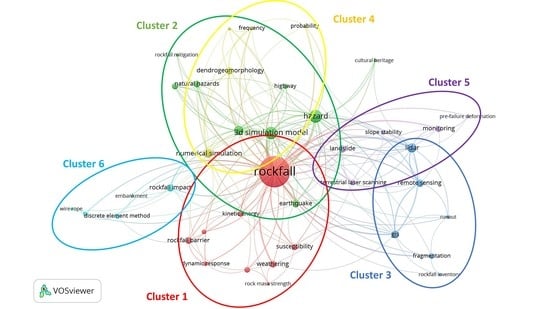
Stage III (2010–2019): Table 11 shows the six clusters obtained in the analysis of this stage: (1) rockfall monitoring (main keywords: “rockfall”, “rockfall barrier”, “weathering”; red circle); (2) 3D simulation model (main keywords: “3D simulation model”, “hazard”, “risk assessment”; green circle); (3) remote sensing (main keywords: “remote sensing”, “LiDAR”, “GIS”; blue circle); (4) numerical simulation (main keywords: “numerical simulation”, “dendrogeomorphology”, “frequency”; yellow circle); (5) slope stability (main keywords: “monitoring”, “landslide”, “terrestrial laser scanning”; purple circle); and (6) rockfall impact (main keywords: “rockfall impact”, “discrete element method”, “energy dissipation”; light blue circle).
At this stage, new techniques, such as the LiDAR device and photogrammetry (3D and 4D), have been performed and used for the spatial detection and prediction of rockfall and the evaluation and analysis of rockfall hazard in new case studies or previous case studies as a checking effect. The number of articles on natural hazards (especially earthquakes) and geomorphology as rockfall triggers have increased [137,138,139]. Among the new themes are some approximations using a model of discrete elements of rock fragmentation after the impact in the analysis of rockfall.
Figure 7 shows the bibliometric map, where we observed the four mentioned clusters in Table 12. Cluster 2 (3D simulation model) and cluster 4 (numerical modeling) are closely related to each other, to such an extent that cluster 4 is almost entirely incorporated into cluster 2. In Figure 7, clusters 1, 2, 4, and 5 they are close to the center of the map. In contrast, clusters 3 (remote sensing) and 6 (rockfall impact) are distant, with very little interaction with the other clusters.
In total, there were 6 cluster topics in this period, out of a total of 13 that existed between 1975 and 2019 (see Table 12 and Figure 5, Figure 6 and Figure 7). The rockfall monitoring topic has stabilized and captured a persistent engagement, albeit with a larger number of articles. Several very new topics that emerged in this period were: rockfall impact, remote sensing, and slope stability. There are no topics to weaken.
4. Discussion
This bibliometric analysis focused on determining the evolution and trend of the researches in terms of authors, citations, journals, and keywords.
Figure 2 shows the number of scientific publications per year, in rockfall-related articles, since 1975. This increase in production can be compared with the global increase in scientific papers in the most productive and outstanding subject areas in Figure 3. In Figure 8, it proceeds to compare, from the years 2000 and 2019, the production of articles in English (such as the search argument carried out in rockfall topic) of the most prominent subject areas. Noting that, the increase in rockfall-related articles is more notable (increases 9.11 times) than the increases in Earth and Planetary Sciences (increases 2.04 times), Environmental Science (increases 3.99 times), and Engineering (increases 2.93 times).
This bibliometric analysis identifies the authors with the most significant number of publications: Stoffel, M. (27), Bourrier, F. (21), Jaboyedoff, M. (17), and Giacomini, A. (16). All of them analyze the theme of rockfall from different perspectives; Stoffel, M. focuses more on the interaction between rockfall and tree ring activity and using Dendromorphology. Bourrier, F. and Giacomini, A. analyze the trajectory of rockfalls using 3D simulators, the efficiency of protective barriers against rockfall and determine danger zones. Finally, Jaboyedoff, M. explains risk zones using different techniques, such as terrestrial laser scanner, kinetic energy, and GIS-based parameter rating.
The analysis shows that the journals with the highest number of articles on the subject are Natural Hazards and Earth System Sciences with 76 publications and Landslides with 54 publications; Geomorphology follows with 41 publications. In the case of Natural Hazards and Earth System Sciences and Landslides, contributions focused on rockfall susceptibility assessments using different scenarios. Finally, Geomorphology contributions aimed at modeling the mountain or slope for path prediction and rockfall hazard analysis.
From the analysis of scientific production in the countries, it was determined that Europe and Asia are the continents with the most research countries on this subject, with 39 of 54 states and their main contributors belong to Europe (8), Asia (3), America (2), and Oceania (2) (Table 3). It should be noted that the countries with the most significant number of publications have areas of mountain ranges on their territory, in some cases with high instability, for example, Italy, France and Switzerland share one of the best-known mountain ranges, the Alps. On the other hand, China, the United States, and Japan have mountainous areas in their territories, but these suffer as a consequence of earthquakes due to its proximity to the so-called Ring of Fire. These are reasons that we have considered to explain the interest in the subject by these countries.
The scientific productivity of institutional collaboration (Table 4) shows that the greatest contribution corresponds to those of French nationality, unlike Table 4, where Italy is the leader. The first institute in Italy is in seventh (Consiglio Nazionale delle Ricerche), which has a production of almost 30% less than the institution located first (Universite Grenoble Alpes). In contrast to Table 4 with Table 5, there are no institutions in the top ten of countries like Canada, Australia, and Spain (sixth, seventh, and eighth, respectively). So, it suggests a variety of institutions in which these publications are distributed. From Table 4, it should also be highlighted that researchers report or register more than one affiliation (two or more institutions from the same country or another country); therefore, the institutions included in Table 4 may match in one or more papers.
Table 13 shows the evolution and variation of the top 15 author keywords in stage I (1990–1999), stage II (2000–2009) and stage III (2010–2019). Landslide, Rockfall, Risk, and Hazard were the author keywords that appear in all stages. The keywords “susceptibility”, “risk”, “hazard”, and “risk assessment” are aspects of rockfall’s susceptibility assessment. “Risk assessment” and “hazard” refer to a quantitative or qualitative assessment of the classification, volume (or area), and spatial distribution of rock slides that exist or may occur in an area [9].
Areas susceptible to rock landslides can be assessed and predicted using empirical methods, analytical methods or kinematic analysis. The need for this type of research caught the attention of researchers and engineers involved in rock landslide risk mitigation and infrastructure planning. The co-occurrence of “hazard” increased continuously, with 1 in 1990–1999 to 12 in 2000–2009 and 46 in 2010–2019; likewise, “risk assessment” (“risk”), with 3 in 1990–1999, to 9 in 2000–2009 and 26 in 2010–2019, suggesting that assessment of rock landslide susceptibility has remained an attractive research topic for the past three decades. “Rockfall” remained the most widely used keyword during the study period because this word was the search argument used in this study.
Rapid developments in remote sensing techniques, “GIS” and “LiDAR” tools made quantitative analysis of rock landslide assessment, analysis and monitoring are more feasible [117,140]. Recently, the availability of GIS and remote sensing data has provided many advantages in quantifying topographic attributes related to rock slides. These techniques are also used to create susceptibility maps and hazard and risk maps. “GIS” has undergone an advance since its appearance in the period 2000–2009; while, the term “LiDAR” only appears in this last decade (2010–2019), its co-occurrence has been very high. This pattern indicates that “remote sensing” has become an essential tool to process and analyze spatial data that facilitate the application of quantitative techniques in the evaluation of rockfall risk.
5. Conclusions and Future Trends
This article presents a review of the academic research carried out on Rockfall during the period 1975–2019, along five dimensions: annual production trends, scientific categories (subjects) and journals, author performance and geographic distribution, institution performance, and the temporal evolution of keyword frequencies. This bibliometric analysis will provide researchers involved in rockfall studies with necessary information about rockfall research, such as its main scientific categories (subjects), its main journals, its active countries/territories and institutions, its most productive authors, and its most used keywords from a historical perspective. With this information, researchers can identify the critical points and frontiers of rockfall investigation. A total of 811 publications were analyzed, involving 1293 authors, 267 journals, 54 countries, 158 institutions, and 1598 different keywords author.
Research on Rockfall has grown since 2002 (beginning of Stage II: Figure 2 and Table 1), and this increase demonstrates the interest of academics in the fields of Earth and Planetary Sciences, Environmental Science, and Engineering. Global geographical distribution of the authors in rockfall research was visualized cartographically, with important spatial groupings in the EE.UU., Europe, Asia, and Oceania. Developed countries, such as Italy, Switzerland, China, the United States, and France, are responsible for 64.73% of scientific publications in this field worldwide. The most productive institution in terms of publications is Universite Grenoble Alpes (Grenoble, France), with 35 publications, followed by INRAE (National Research Institute for Agriculture, Food and Environment of France) and Chinese Academy of Sciences. The leading journals, according to the number of publications, in this scientific field are Natural Hazards and Earth System Sciences, Landslides, and Geomorphology. Likewise, the prominent authors are Stoffel, M., from the Université de Genève (Genève, Switzerland); Bourrier, F., from the Universite Grenoble Alpes (Grenoble, France), and Jaboyedoff, M., from the Université de Lausanne (Lausanne, Switzerland).
Bibliometry is presented as a suitable methodology for inductive approaches to the semantic limits of the conceptual structure of recently developed disciplines. In our case study on rockfall, we elucidate the multidisciplinary nature of this area of knowledge. The use of bibliometrics can improve our understanding and help researchers to better understand the conceptual structure of rockfall, as in any other scientific field.
A temporal evolution analysis of keyword frequencies was used to shed light on the general research directions and trends in rockfall and to provide reference for future study. In the most recent ten years (2010–2019), several author keywords (Table 13), such as “hazard”, “3D simulation model”, “risk assessment”, “remote sensing”, “numerical simulation”, “earthquake”, “rockfall barrier”, “LiDAR”, and “GIS”, became the research hotspots in rockfall research, which were in the areas of regional susceptibility assessment, typical deformation monitoring and prediction, effective research technologies, and models. Moreover, two hot issue (hazard-risk assessment and 3D simulation model), one major triggering factor (earthquakes), three research technologies (GIS, LiDAR, and remote sensing), and one effective model (numerical simulation by a algorithms) received steadily increasing attention, indicating likely future rockfall-related research in these areas. From this we can highlight the following topics:
- (i)
- For development of a reliable and automatic rockfall monitoring system, remote sensing techniques, such as LiDAR or photogrammetry, have been combined with the development of innovative data processing methods (seismic measurements). Until now, the combination of remote sensing techniques with seismic measurements remains scarce. Therefore, additional calibration work is necessary to corroborate the utility of combining both methods.
- (ii)
- For hazard-risk assessment, many machine learning algorithms, such as backpropagation neural network (BPNN), support vector machine (SVM), or using remote sensing (LiDAR, Terrestrial laser scanning-TLS, airborne LiDAR system-ALS, or UAV 3D Photogrammetry), have been widely used to perform the susceptibility assessment. In addition, in recent years, it has been carried out for the protection of Cultural Heritage. This in the frame of a quick protocol for a preliminary zonation, to ensure the safe and sustainable management of the sites.
- (iii)
- To determine the trajectories, the potential runout, and impact energies, the use of numerical and models in 2D-3D simulations are being developed, such as: stochastic program (RockGIS) for rockfall fractal fragmentation model (RFFM) or simulation software uses the point-mass model (STONE, RockFall Analyst and PICSUS-ROCKnROLL). However, a greater number of parametric analyses and calibration exercises are required.
- (iv)
- GIS-based techniques, physical-based approaches, and also new technologies (such as big-data analysis of monitoring systems) could play an important role in the future for the mitigation and management of rockfall events.
This study had its limitations and implications for future research. First, an opportunity to continue deepening knowledge of rockfall, as a discipline, could be to expand the study using other databases, such as Web of Science (WoS), or using different types of documents and other languages. Second, the research has used the citations provided by the Scopus database as the unit of analysis, so the implications of self-citations and citations should be considered in future research. These could complement the survey so that all the scientific production is considered and the conclusions are more rigorous and better reflect the evolution of disciplinary structures. Furthermore, it would be fascinating to approach the study of intellectual structure through the study of citation, bibliographic coupling, and co-citation because it is a part little explored by bibliometric studies, and it would be of the most significant interest to understand the complete structure of this scientific domain. This analysis of the intellectual structure would reflect the degree of internationalization of a discipline. In addition, a comparative analysis of keyword co-occurrence can be suggested, and results can be compared based on keyword type selection. Here, whether or not taking all the keywords for the analysis could alter the results could be studied.
Author Contributions
Conceptualization, N.M.-B. and J.B.-B.; methodology, N.M.-B.; software, J.B.-B.; validation, N.M.-B., F.M.-C. and P.C.-M.; formal analysis, N.M.-B. and J.B.-B.; investigation, J.B.-B.; data curation, N.M.-B. and J.B.-B.; writing—Original draft preparation, J.B.-B.; writing—Review and editing, N.M.-B., P.C.-M., F.M.-C. and J.B.-B.; supervision, P.C.-M. and F.M.-C. All authors have read and agreed to the published version of the manuscript.
Funding
This research received no external funding.
Acknowledgments
This work has been made possible by the valuable collaboration of the ESPOL research project: “Register of geological and mining heritage and its incidence in the defense and preservation of geodiversity in Ecuador” under grant No. CIPAT-01-2018; and the support of NOVA Science Research Associates. Also, to the master’s degree in geotechnics from ESPOL, for its acceptance and support in this research topic. And to Luis Jordá for his support and advice as a co-tutor and specialist in this research area.
Conflicts of Interest
The authors declare no conflict of interest.
References
- Ritchie, A.M. Evaluation of Rockfall and Its Control. Highw. Res. Rec. 1963, 17, 13–28. [Google Scholar]
- Yang, P.; Shang, Y.; Li, Y.; Wang, H.; Li, K. Analysis of Potential Rockfalls on a Highway at High Slopes in Cold-Arid Areas (Northwest Xinjiang, China). Sustainability 2017, 9, 414. [Google Scholar] [CrossRef] [Green Version]
- Cruden, D.M.; Varnes, D.J. Landslide types and processes. Spec. Rep. Natl. Res. Counc. Transp. Res. Board 1996, 247, 36–75. [Google Scholar]
- Žabota, B.; Kobal, M. A New Methodology for Mapping Past Rockfall Events: From Mobile Crowdsourcing to Rockfall Simulation Validation. ISPRS Int. J. Geo-Inf. 2020, 9, 514. [Google Scholar] [CrossRef]
- Selby, M.J. Hillslope Materials and Processes; Oxford University Press: Oxford, UK, 1982. [Google Scholar]
- Davies, T.R.H. Spreading of rock avalanche debris by mechanical fluidization. Rock Mech. Felsmech. Méc. Roches 1982, 15, 9–24. [Google Scholar] [CrossRef]
- Abele, G. Large rockslides: Their causes and movement on internal sliding planes. Mt. Res. Dev. 1994, 14, 315–320. [Google Scholar] [CrossRef]
- Melosh, H.J. Giant rock avalanches. Nature 1990, 348, 483–484. [Google Scholar] [CrossRef]
- Dorren, L.K.A. A review of rockfall mechanics and modelling approaches. Prog. Phys. Geogr. 2003, 27, 69–87. [Google Scholar] [CrossRef]
- Legros, F. The mobility of long-runout landslides. Eng. Geol. 2002, 63, 301–331. [Google Scholar] [CrossRef]
- Matsuoka, N.; Sakai, H. Rockfall activity from an alpine cliff during thawing periods. Geomorphology 1999, 28, 309–328. [Google Scholar] [CrossRef]
- Ge, Y.; Tang, H.; Ez Eldin, M.A.M.; Chen, H.; Zhong, P.; Zhang, L.; Fang, K. Deposit characteristics of the Jiweishan rapid long-runout landslide based on field investigation and numerical modeling. Bull. Eng. Geol. Environ. 2019, 78, 4383–4396. [Google Scholar] [CrossRef]
- Scheidegger, A.E. On the prediction of the reach and velocity of catastrophic landslides. Rock Mech. Felsmech. Méc. Roches 1973, 5, 231–236. [Google Scholar] [CrossRef]
- Marzorati, S.; Luzi, L.; De Amicis, M. Rock falls induced by earthquakes: A statistical approach. Soil Dyn. Earthq. Eng. 2002, 22, 565–577. [Google Scholar] [CrossRef]
- Ge, Y.; Zhou, T.; Tang, H.; Lin, Z. Influence of the impact angle on the motion and deposition of granular flows. Eng. Geol. 2020, 275, 105746. [Google Scholar] [CrossRef]
- Sassa, K.; Tsuchiya, S.; Ugai, K.; Wakai, A.; Uchimura, T. Landslides: A review of achievements in the first 5 years (2004–2009). Landslides 2009, 6, 275–286. [Google Scholar] [CrossRef]
- Ulusay, R.; Gokceoglu, C.; Topal, T.; Sonmez, H.; Tuncay, E.; Erguler, Z.A.; Kasmer, O. Assessment of environmental and engineering geological problems for the possible re-use of an abandoned rock-hewn settlement in Urgüp (Cappadocia), Turkey. Environ. Geol. 2006, 50, 473–494. [Google Scholar] [CrossRef]
- Tunusluoglu, M.C.; Zorlu, K. Rockfall hazard assessment in a cultural and natural heritage (Ortahisar Castle, Cappadocia, Turkey). Environ. Geol. 2009, 56, 963–972. [Google Scholar] [CrossRef]
- Abebe, B.; Dramis, F.; Fubelli, G.; Umer, M.; Asrat, A. Landslides in the Ethiopian highlands and the Rift margins. J. Afr. Earth Sci. 2010, 56, 131–138. [Google Scholar] [CrossRef]
- Morante, F.; Aguilar, M.; Ramírez, G.; Blanco, R.; Carrión, P.; Briones, J.; Berrezueta, E. Evaluation of Slope Stability Considering the Preservation of the General Patrimonial Cemetery of Guayaquil, Ecuador. Geosciences 2019, 9, 103. [Google Scholar] [CrossRef] [Green Version]
- Hewitt, K.; Clague, J.J.; Orwin, J.F. Legacies of catastrophic rock slope failures in mountain landscapes. Earth Sci. Rev. 2008, 87, 1–38. [Google Scholar] [CrossRef]
- Lambert, S.; Bourrier, F. Design of rockfall protection embankments: A review. Eng. Geol. 2013, 154, 77–88. [Google Scholar] [CrossRef]
- Zangerl, C.; Evans, K.F.; Eberhardt, E.; Loew, S. Consolidation settlements above deep tunnels in fractured crystalline rock: Part 1-Investigations above the Gotthard highway tunnel. Int. J. Rock Mech. Min. Sci. 2008, 45, 1195–1210. [Google Scholar] [CrossRef]
- Wolter, A.; Stead, D.; Clague, J.J. A morphologic characterisation of the 1963 Vajont Slide, Italy, using long-range terrestrial photogrammetry. Geomorphology 2014, 206, 147–164. [Google Scholar] [CrossRef]
- Stoffel, M.; Tiranti, D.; Huggel, C. Climate change impacts on mass movements—Case studies from the European Alps. Sci. Total Environ. 2014, 493, 1255–1266. [Google Scholar] [CrossRef] [PubMed]
- Ravanel, L.; Magnin, F.; Deline, P. Impacts of the 2003 and 2015 summer heatwaves on permafrost-affected rock-walls in the Mont Blanc massif. Sci. Total Environ. 2017, 609, 132–143. [Google Scholar] [CrossRef] [PubMed]
- Aguilar Aguilar, M.; Briones Bitar, J.; Carrión Mero, P.; Chávez, M.A.; Morante Carballo, F. Diseño de las soluciones de estabilización en el cementerio patrimonial de Guayaquil, Ecuador. In Proceedings of the 17th LACCEI International Multi-Conference for Engineering, Education, and Technology: “Industry, Innovation, and Infrastructure for Sustainable Cities and Communities”, Montego Bay, Jamaica, 24–26 July 2019; Latin American and Caribbean Consortium of Engineering Institutions: Boca Ratón, FL, USA, 2019. [Google Scholar]
- Fell, R. Landslide risk assessment and acceptable risk. Can. Geotech. J. 1994, 31, 261–272. [Google Scholar] [CrossRef]
- Scavia, C.; Barbero, M.; Castelli, M.; Marchelli, M.; Peila, D.; Torsello, G.; Vallero, G. Evaluating rockfall risk: Some critical aspects. Geosciences 2020, 10, 98. [Google Scholar] [CrossRef] [Green Version]
- Cagnoli, B.; Romano, G.P. Effect of grain size on mobility of dry granular flows of angular rock fragments: An experimental determination. J. Volcanol. Geotherm. Res. 2010, 193, 18–24. [Google Scholar] [CrossRef]
- Aguilar, M.; Torrens, R.B.; Bernal, C.B.; Bitar, J.B.; Mero, P.C.; Carballo, F.M. Caracterización geomecánica y análisis de las afectaciones del macizo rocoso en el casco urbano de Zaruma, Ecuador. In Proceedings of the 17th LACCEI International Multi-Conference for Engineering, Education, and Technology: “Industry, Innovation, and Infrastructure for Sustainable Cities and Communities”, Montego Bay, Jamaica, 24–26 July 2019; Latin American and Caribbean Consortium of Engineering Institutions: Boca Ratón, FL, USA, 2019. [Google Scholar]
- Evans, S.G.; Hungr, O. The assessment of rockfall hazard at the base of talus slopes. Can. Geotech. J. 1993, 30, 620–636. [Google Scholar] [CrossRef]
- Crosta, G.B.; Agliardi, F. Natural Hazards and Earth System Sciences A methodology for physically based rockfall hazard assessment. Nat. Hazards Earth Syst. Sci. 2003, 3, 407–422. [Google Scholar] [CrossRef]
- Peila, D.; Guardini, C. Natural Hazards and Earth System Sciences Use of the event tree to assess the risk reduction obtained from rockfall protection devices. Hazards Earth Syst. Sci 2008, 8, 1441–1450. [Google Scholar] [CrossRef] [Green Version]
- Saroglou, H.; Marinos, V.; Marinos, P.; Tsiambaos, G. Rockfall hazard and risk assessment: An example from a high promontory at the historical site of Monemvasia, Greece. Nat. Hazards Earth Syst. Sci. 2012, 12, 1823–1836. [Google Scholar] [CrossRef] [Green Version]
- Ansari, M.K.; Ahmad, M.; Singh, T.N. Rockfall Risk Assessment along Mumbai-Pune Expressway, Maharashtra, India. Int. J. Sci. Res. 2004, 3, 2012–2014. [Google Scholar]
- Macciotta, R.; Martin, C.D.; Morgenstern, N.R.; Cruden, D.M. Quantitative risk assessment of slope hazards along a section of railway in the Canadian Cordillera—A methodology considering the uncertainty in the results. Landslides 2016, 13, 115–127. [Google Scholar] [CrossRef]
- Cascini, L. Applicability of landslide susceptibility and hazard zoning at different scales. Eng. Geol. 2008, 102, 164–177. [Google Scholar] [CrossRef]
- Ferrari, F.; Giacomini, A.; Thoeni, K. Qualitative Rockfall Hazard Assessment: A Comprehensive Review of Current Practices. Rock Mech. Rock Eng. 2016, 49, 2865–2922. [Google Scholar] [CrossRef]
- Giacomini, A.; Thoeni, K.; Santise, M.; Diotri, F.; Booth, S.; Fityus, S.; Roncella, R. Temporal-Spatial Frequency Rockfall Data from Open-Pit Highwalls Using a Low-Cost Monitoring System. Remote Sens. 2020, 12, 2459. [Google Scholar] [CrossRef]
- Spang, R.M.; SöNser, T. Optimized rockfall protection by “ROCKFALL”. In Proceedings of the 8th ISRM Congress, Tokyo, Japan, 25–29 September 1995; pp. 1233–1242. [Google Scholar]
- Peila, D.; Pelizza, S.; Sassudelli, F. Evaluation of behaviour of rockfall restraining nets by full scale tests. Rock Mech. Rock Eng. 1998, 31, 1–24. [Google Scholar] [CrossRef]
- Kienholz, H.; Mani, P. Assessment of geomorphic hazards and priorities for forest management on the Rigi north face, Switzerland. Mt. Res. Dev. 1994, 14, 321–328. [Google Scholar] [CrossRef]
- Motta, R.; Haudemand, J. Protected forests and silviculture stability: An example of planning in the Aosta Valley. Mt. Res. Dev. 2000, 20, 180–187. [Google Scholar] [CrossRef] [Green Version]
- Buckley, S.J.; Howell, J.A.; Enge, H.D.; Kurz, T.H. Terrestrial laser scanning in geology: Data acquisition, processing and accuracy considerations. J. Geol. Soc. Lond. 2008, 165, 625–638. [Google Scholar] [CrossRef]
- Lato, M.J.; Diederichs, M.S.; Hutchinson, D.J.; Harrap, R. Evaluating roadside rockmasses for rockfall hazards using LiDAR data: Optimizing data collection and processing protocols. Nat. Hazards 2012, 60, 831–864. [Google Scholar] [CrossRef]
- Lan, H.; Derek Martin, C.; Lim, C.H. RockFall analyst: A GIS extension for three-dimensional and spatially distributed rockfall hazard modeling. Comput. Geosci. 2007, 33, 262–279. [Google Scholar] [CrossRef]
- Yan, Y.; Li, T.; Liu, J.; Wang, W.; Su, Q. Monitoring and early warning method for a rockfall along railways based on vibration signal characteristics. Sci. Rep. 2019, 9, 1–10. [Google Scholar] [CrossRef]
- Noetzli, J.; Hoelzle, M.; Haeberli, W. Mountain permafrost and recent Alpine rock-fall events: A GIS-based approach to determine critical factors. Permafrost 2003, 2, 827–832. [Google Scholar]
- Volkwein, A.; Schellenberg, K.; Labiouse, V.; Agliardi, F.; Berger, F.; Bourrier, F.; Dorren, L.K.A.; Gerber, W.; Jaboyedoff, M. Rockfall characterisation and structural protection—A review. Nat. Hazards Earth Syst. Sci. 2011, 11, 2617–2651. [Google Scholar] [CrossRef] [Green Version]
- Tranfield, D.; Denyer, D.; Smart, P. Towards a Methodology for Developing Evidence-Informed Management Knowledge by Means of Systematic Review. Br. J. Manag. 2003, 14, 207–222. [Google Scholar] [CrossRef]
- Colicchia, C.; Strozzi, F. Supply chain risk management: A new methodology for a systematic literature review. Supply Chain Manag. 2012, 17, 403–418. [Google Scholar] [CrossRef]
- Mentzer, J.T.; Kahn, K.B. A Framework of Logistics Research. J. Bus. Logist. 1995, 16, 231–250. [Google Scholar]
- Rowley, J.; Slack, F. Conducting a literature review. Manag. Res. News 2004, 27, 31–39. [Google Scholar] [CrossRef]
- Fahimnia, B.; Sarkis, J.; Davarzani, H. Green supply chain management: A review and bibliometric analysis. Int. J. Prod. Econ. 2015, 162, 101–114. [Google Scholar] [CrossRef]
- Carrión-Mero, P.; Montalván-Burbano, N.; Paz-Salas, N.; Morante-Carballo, F. Volcanic Geomorphology: A Review of Worldwide Research. Geosciences 2020, 10, 347. [Google Scholar] [CrossRef]
- Vaz, C.R.; Shoeninger, T.R.S.; Lezana, Á.G.R. Sustainability and Innovation in the Automotive Sector: A Structured Content Analysis. Sustainability 2017, 9, 880. [Google Scholar]
- Zhang, Y.; Zhang, Y.; Shi, K.; Yao, X. Research development, current hotspots, and future directions of water research based on MODIS images: A critical review with a bibliometric analysis. Environ. Sci. Pollut. Res. 2017, 24, 15226–15239. [Google Scholar] [CrossRef] [PubMed]
- Caiado, R.G.G.; de Freitas Dias, R.; Mattos, L.V.; Quelhas, O.L.G.; Leal Filho, W. Towards sustainable development through the perspective of eco-efficiency—A systematic literature review. J. Clean. Prod. 2017, 165, 890–904. [Google Scholar] [CrossRef]
- Zhong, S.; Geng, Y.; Liu, W.; Gao, C.; Chen, W. A bibliometric review on natural resource accounting during 1995–2014. J. Clean. Prod. 2016, 139, 122–132. [Google Scholar] [CrossRef]
- Huang, L.; Zhang, Y.; Guo, Y.; Zhu, D.; Porter, A.L. Four dimensional Science and Technology planning: A new approach based on bibliometrics and technology roadmapping. Technol. Forecast. Soc. Chang. 2014, 81, 39–48. [Google Scholar] [CrossRef]
- Montalván-Burbano, N.; Pérez-Valls, M.; Plaza-Úbeda, J. Analysis of scientific production on organizational innovation. Cogent Bus. Manag. 2020, 7. [Google Scholar] [CrossRef]
- Geng, Y.; Chen, W.; Liu, Z.; Chiu, A.S.F.; Han, W.; Liu, Z.; Zhong, S.; Qian, Y.; You, W.; Cui, X. A bibliometric review: Energy consumption and greenhouse gas emissions in the residential sector. J. Clean. Prod. 2017, 159, 301–316. [Google Scholar] [CrossRef]
- Liu, X.; Zhan, F.B.; Hong, S.; Niu, B.; Liu, Y. A bibliometric study of earthquake research: 1900–2010. Scientometrics 2012, 92, 747–765. [Google Scholar] [CrossRef]
- Camargo, J.; Silva, M.; Ferreira Júnior, A.; Araújo, T. Marine Geohazards: A Bibliometric-Based Review. Geosciences 2019, 9, 100. [Google Scholar] [CrossRef] [Green Version]
- Dillon, P.; Stuyfzand, P.; Grischek, T.; Lluria, M.; Pyne, R.D.G.; Jain, R.C.; Bear, J.; Schwarz, J.; Wang, W.; Fernandez, E.; et al. Sixty years of global progress in managed aquifer recharge. Hydrogeol. J. 2019, 27, 1–30. [Google Scholar] [CrossRef] [Green Version]
- Gokceoglu, C.; Sezer, E. A statistical assessment on international landslide literature (1945–2008). Landslides 2009, 6, 345–351. [Google Scholar] [CrossRef]
- Wu, X.; Chen, X.; Zhan, F.B.; Hong, S. Global research trends in landslides during 1991–2014: A bibliometric analysis. Landslides 2015, 12, 1215–1226. [Google Scholar] [CrossRef]
- Zhuang, Y.; Liu, X.; Nguyen, T.; He, Q.; Hong, S. Global remote sensing research trends during 1991–2010: A bibliometric analysis. Scientometrics 2013, 96, 203–219. [Google Scholar] [CrossRef]
- Ferreira, R.H.M.; Picinin, C.T. Bibliometric analysis for characterization of oil production in Brazilian territory. Scientometrics 2018, 116, 1945–1974. [Google Scholar] [CrossRef]
- Herrera-Franco, G.; Montalván-Burbano, N.; Carrión-Mero, P.; Apolo-Masache, B.; Jaya-Montalvo, M. Research Trends in Geotourism: A Bibliometric Analysis Using the Scopus Database. Geosciences 2020, 10, 379. [Google Scholar] [CrossRef]
- Cobo, M.J.; Chiclana, F.; Collop, A.; De Ona, J.; Herrera-Viedma, E. A bibliometric analysis of the intelligent transportation systems research based on science mapping. IEEE Trans. Intell. Transp. Syst. 2014, 15, 901–908. [Google Scholar] [CrossRef] [Green Version]
- Albort-Morant, G.; Henseler, J.; Leal-Millán, A.; Cepeda-Carrión, G. Mapping the Field: A Bibliometric Analysis of Green Innovation. Sustainability 2017, 9, 1011. [Google Scholar] [CrossRef] [Green Version]
- Salmerón-Manzano, E.; Manzano-Agugliaro, F. Worldwide Scientific Production Indexed by Scopus on Labour Relations. Publications 2017, 5, 25. [Google Scholar] [CrossRef] [Green Version]
- Cobo, M.J.; López-Herrera, A.G.; Herrera-Viedma, E.; Herrera, F. Science mapping software tools: Review, analysis, and cooperative study among tools. J. Am. Soc. Inf. Sci. Technol. 2011, 62, 1382–1402. [Google Scholar] [CrossRef]
- López-Illescas, C.; de Moya-Anegón, F.; Moed, H.F. Coverage and citation impact of oncological journals in the Web of Science and Scopus. J. Informetr. 2008, 2, 304–316. [Google Scholar] [CrossRef]
- Sánchez, A.D.; de la Cruz Del Río Rama, M.; García, J.Á. Bibliometric analysis of publications on wine tourism in the databases Scopus and WoS. Eur. Res. Manag. Bus. Econ. 2017, 23, 8–15. [Google Scholar] [CrossRef] [Green Version]
- Mongeon, P.; Paul-Hus, A. The journal coverage of Web of Science and Scopus: A comparative analysis. Scientometrics 2016, 106, 213–228. [Google Scholar] [CrossRef]
- Elsevier Scopus Content Coverage Guide. Available online: https://0-www-elsevier-com.brum.beds.ac.uk/solutions/scopus/how-scopus-works/content (accessed on 25 March 2020).
- Repiso, R. Aproximación Bibliométrica del Desarrollo e Impacto de la Investigación Internacional en Alfabetización Audiovisual (1960–2011). Icono14 2012, 10, 1697–8293. [Google Scholar] [CrossRef] [Green Version]
- Cheng, M.; Edwards, D.; Darcy, S.; Redfern, K. A Tri-Method Approach to a Review of Adventure Tourism Literature: Bibliometric Analysis, Content Analysis, and a Quantitative Systematic Literature Review. J. Hosp. Tour. Res. 2018, 42, 997–1020. [Google Scholar] [CrossRef] [Green Version]
- Rodrigues, S.P.; Van Eck, N.J.; Waltman, L.; Jansen, F.W. Mapping patient safety: A large-scale literature review using bibliometric visualisation techniques. BMJ Open 2014, 4, e004468. [Google Scholar] [CrossRef]
- López-Muñoz, F.; Alamo, C.; Quintero-Gutiérrez, F.J.; García-García, P. A bibliometric study of international scientific productivity in attention-deficit hyperactivity disorder covering the period 1980-2005. Eur. Child Adolesc. Psychiatry 2008, 17, 381–391. [Google Scholar] [CrossRef]
- Maia, S.C.; de Benedicto, G.C.; do Prado, J.W.; Robb, D.A.; de Almeida Bispo, O.N.; de Brito, M.J. Mapping the Literature on Credit Unions: A Bibliometric Investigation Grounded in Scopus and Web of Science; Springer International Publishing: Cham, Switzerland, 2019; Volume 120, ISBN 0123456789. [Google Scholar]
- Ramos-Rodríguez, A.-R.; Ruíz-Navarro, J. Changes in the intellectual structure of strategic management research: A bibliometric study of theStrategic Management Journal, 1980–2000. Strateg. Manag. J. 2004, 25, 981–1004. [Google Scholar] [CrossRef]
- Milán-García, J.; Uribe-Toril, J.; Ruiz-Real, J.; de Pablo Valenciano, J. Sustainable Local Development: An Overview of the State of Knowledge. Resources 2019, 8, 31. [Google Scholar] [CrossRef] [Green Version]
- Serrano, L.; Sianes, A.; Ariza-Montes, A. Using Bibliometric Methods to Shed Light on the Concept of Sustainable Tourism. Sustainability 2019, 11, 6964. [Google Scholar] [CrossRef] [Green Version]
- Aznar-Sánchez, J.; García-Gómez, J.; Velasco-Muñoz, J.; Carretero-Gómez, A. Mining Waste and Its Sustainable Management: Advances in Worldwide Research. Minerals 2018, 8, 284. [Google Scholar] [CrossRef] [Green Version]
- Niñerola, A.; Sánchez-Rebull, M.-V.; Hernández-Lara, A.-B. Tourism Research on Sustainability: A Bibliometric Analysis. Sustainability 2019, 11, 1377. [Google Scholar] [CrossRef] [Green Version]
- Van Eck, N.J.; Waltman, L. Citation-based clustering of publications using CitNetExplorer and VOSviewer. Scientometrics 2017, 111, 1053–1070. [Google Scholar] [CrossRef] [Green Version]
- Waltman, L.; van Eck, N.J.; Noyons, E.C.M. A unified approach to mapping and clustering of bibliometric networks. J. Informetr. 2010, 4, 629–635. [Google Scholar] [CrossRef] [Green Version]
- Emmer, A. Geographies and Scientometrics of Research on Natural Hazards. Geosciences 2018, 8, 382. [Google Scholar] [CrossRef] [Green Version]
- Garrigos-Simon, F.; Narangajavana-Kaosiri, Y.; Lengua-Lengua, I. Tourism and Sustainability: A Bibliometric and Visualization Analysis. Sustainability 2018, 10, 1976. [Google Scholar] [CrossRef] [Green Version]
- Van Eck, N.J.; Waltman, L. Software survey: VOSviewer, a computer program for bibliometric mapping. Scientometrics 2010, 84, 523–538. [Google Scholar] [CrossRef] [Green Version]
- Van Eck, N.J.; Waltman, L. Bibliometric mapping of the computational intelligence field. Int. J. Uncertain. Fuzziness Knowl. Based Syst. 2007, 15, 625–645. [Google Scholar] [CrossRef]
- Van Eck, N.J.; Waltman, L. VOS: A New Method for Visualizing Similarities Between Objects. In Studies in Classification, Data Analysis, and Knowledge Organization; Springer: Berlin/Heidelberg, Germany, 2007; pp. 299–306. ISBN 9783540709800. [Google Scholar]
- R.H.O. Coal mine rock falls. J. Frankl. Inst. 1942, 233, 99–100. [Google Scholar] [CrossRef]
- Mudge, M.R. Rockfall-avalanche and rockslide-avalanche deposits at Sawtooth Ridge, Montana. Bull. Geol. Soc. Am. 1965, 76, 1003–1014. [Google Scholar] [CrossRef]
- Sheinin, V.I. Determination of the statistical characteristics of rock falls on the periphery of an unsupported underground working. Sov. Min. Sci. 1969, 5, 373–378. [Google Scholar] [CrossRef]
- Surge Effects in a Lake as a Consequence of Rockfalls. Model Tests to Predict the Effects of Avalanches of Rock on the Walensee. Available online: https://0-www-scopus-com.brum.beds.ac.uk/results/results.uri?sort=cp-f&src=s&sid=819f886a73352e6925e033e987a3dee2&sot=a&sdt=a&cluster=scosubtype%2c%22ar%22%2ct%2bscopubyr%2c%222020%22%2cf%2bscolang%2c%22English%22%2ct&sl=50&s=%28+TITLE+%28+%22Rock-fall*%22+%29+OR+TITLE+%28+%22Rockfall*%22+%29%29&origin=savedSearchNewOnly&txGid=09a8e8507e81b6ae4654b5661b839234 (accessed on 1 October 2020).
- Moos, C.; Thomas, M.; Pauli, B.; Bergkamp, G.; Stoffel, M.; Dorren, L. Economic valuation of ecosystem-based rockfall risk reduction considering disturbances and comparison to structural measures. Sci. Total Environ. 2019, 697, 134077. [Google Scholar] [CrossRef] [PubMed]
- Robotham, M.E.; Wang, H.; Walton, G. Assessment of risk from rockfall from active and abandoned quarry slopes. Trans. Inst. Min. Metall. Sect. A 1995, 104, 237A. [Google Scholar]
- Bunce, C.M.; Cruden, D.M.; Morgenstern, N.R. Assessment of the hazard from rock fall on a highway. Can. Geotech. J. 1997, 34, 344–356. [Google Scholar] [CrossRef]
- Girod, F.; Thélin, P. Weathering of granitic rocks in the Alps: Preliminary results from orthogneiss associated with the Randa rockfall (Matter Valley, Valais, Switzerland). Schweiz. Miner. Petrogr. Mitt. 1998, 78, 179–184. [Google Scholar]
- Ayonghe, S.N.; Mafany, G.T.; Ntasin, E.; Samalang, P. Seismically activated swarm of landslides, tension cracks, and a rockfall after heavy rainfall in Bafaka, Cameroon. Nat. Hazards 1999, 19, 13–27. [Google Scholar] [CrossRef]
- Keylock, C.; Domaas, U. Evaluation of Topographic Models of Rockfall Travel Distance for Use in Hazard Applications. Arctic Antarct. Alp. Res. 1999, 31, 312. [Google Scholar] [CrossRef]
- Chan, K.S.; Lee, Y. A fracture mechanics-based model for assessing the mechanical failure of nuclear fuel rods due to rock fall. Nucl. Eng. Des. 2000, 201, 209–226. [Google Scholar] [CrossRef]
- Nicot, F.; Cambou, B.; Mazzoleni, G. Design of rockfall restraining nets from a discrete element modelling. Rock Mech. Rock Eng. 2001, 34, 99–118. [Google Scholar] [CrossRef]
- Guzzetti, F.; Crosta, G.; Detti, R.; Agliardi, F. STONE: A computer program for the three-dimensional simulation of rock-falls. Comput. Geosci. 2002, 28, 1079–1093. [Google Scholar] [CrossRef]
- Agliardi, F.; Crosta, G.B. High resolution three-dimensional numerical modelling of rockfalls. Int. J. Rock Mech. Min. Sci. 2003, 40, 455–471. [Google Scholar] [CrossRef]
- Corominas, J.; Copons, R.; Moya, J.; Vilaplana, J.M.; Altimir, J.; Amigó, J. Quantitative assessment of the residual risk in a rockfall protected area. Landslides 2005, 2, 343–357. [Google Scholar] [CrossRef]
- Guzzetti, F.; Reichenbach, P.; Wieczorek, G.F. Rockfall hazard and risk assessment in the Yosemite Valley, California, USA. Nat. Hazards Earth Syst. Sci. 2003, 3, 491–503. [Google Scholar] [CrossRef] [Green Version]
- Dorren, L.K.A.; Berger, F.; Putters, U.S. Real-size experiments and 3-D simulation of rockfall on forested and non-forested slopes. Nat. Hazards Earth Syst. Sci. 2006, 6, 145–153. [Google Scholar] [CrossRef] [Green Version]
- Stoffel, M.; Schneuwly, D.; Bollschweiler, M.; Lièvre, I.; Delaloye, R.; Myint, M.; Monbaron, M. Analyzing rockfall activity (1600–2002) in a protection forest—A case study using dendrogeomorphology. Geomorphology 2005, 68, 224–241. [Google Scholar] [CrossRef]
- Dupire, S.; Bourrier, F.; Monnet, J.M.; Bigot, S.; Borgniet, L.; Berger, F.; Curt, T. The protective effect of forests against rockfalls across the French Alps: Influence of forest diversity. For. Ecol. Manag. 2016, 382, 269–279. [Google Scholar] [CrossRef] [Green Version]
- Saroglou, C.; Asteriou, P.; Zekkos, D.; Tsiambaos, G.; Clark, M.; Manousakis, J. UAV-based mapping, back analysis and trajectory modeling of a coseismic rockfall in Lefkada island, Greece. Nat. Hazards Earth Syst. Sci. 2018, 18, 321–333. [Google Scholar] [CrossRef] [Green Version]
- Fanos, A.M.; Pradhan, B. A Spatial Ensemble Model for Rockfall Source Identification from High Resolution LiDAR Data and GIS. IEEE Access 2019, 7, 74570–74585. [Google Scholar] [CrossRef]
- Kromer, R.; Lato, M.; Hutchinson, D.J.; Gauthier, D.; Edwards, T. Managing rockfall risk through baseline monitoring of precursors using a terrestrial laser scanner. Can. Geotech. J. 2017, 54, 953–967. [Google Scholar] [CrossRef]
- Price, D.D.S. A general theory of bibliometric and other cumulative advantage processes. J. Am. Soc. Inf. Sci. 1976, 27, 292–306. [Google Scholar] [CrossRef] [Green Version]
- Parish, A.J.; Boyack, K.W.; Ioannidis, J.P.A. Dynamics of co-authorship and productivity across different fields of scientific research. PLoS ONE 2018, 13, e0189742. [Google Scholar] [CrossRef] [PubMed]
- Kumar, S. Co-authorship networks: A review of the literature. Aslib J. Inf. Manag. 2015, 67, 55–73. [Google Scholar] [CrossRef]
- Zupic, I.; Čater, T. Bibliometric Methods in Management and Organization. Organ. Res. Methods 2015, 18, 429–472. [Google Scholar] [CrossRef]
- Garfield, E. Citation analysis as a tool in journal evaluation. Science 1972, 178, 471–479. [Google Scholar] [CrossRef] [PubMed]
- Hsü, K.J. Catastrophic debris streams (sturzstroms) generated by rockfalls. Bull. Geol. Soc. Am. 1975, 86, 129–140. [Google Scholar] [CrossRef]
- Hungr, O.; Evans, S.G.; Hazzard, J. Magnitude and frequency of rock falls and rock slides along the main transportation corridors of southwestern British Columbia. Can. Geotech. J. 1999, 36, 224–238. [Google Scholar] [CrossRef]
- Chau, K.T.; Wong, R.H.C.; Wu, J.J. Coefficient of restitution and rotational motions of rockfall impacts. Int. J. Rock Mech. Min. Sci. 2002, 39, 69–77. [Google Scholar] [CrossRef]
- Abellán, A.; Jaboyedoff, M.; Oppikofer, T.; Vilaplana, J.M. Detection of millimetric deformation using a terrestrial laser scanner: Experiment and application to a rockfall event. Nat. Hazards Earth Syst. Sci. 2009, 9, 365–372. [Google Scholar] [CrossRef] [Green Version]
- Dade, W.B.; Huppert, H.E. Long-runout rockfalls. Geology 1998, 26, 803–806. [Google Scholar] [CrossRef]
- Hirsch, J.E. An index to quantify an individual’s scientific research output. Proc. Natl. Acad. Sci. USA 2005, 102, 16569–16572. [Google Scholar] [CrossRef] [PubMed] [Green Version]
- Dong, D.; Chen, M.-L. Publication trends and co-citation mapping of translation studies between 2000 and 2015. Scientometrics 2015, 105, 1111–1128. [Google Scholar] [CrossRef]
- Peng, Y.; Lin, A.; Wang, K.; Liu, F.; Zeng, F.; Yang, L. Global trends in DEM-related research from 1994 to 2013: A bibliometric analysis. Scientometrics 2015, 105, 347–366. [Google Scholar] [CrossRef]
- Baier-Fuentes, H.; Merigó, J.M.; Amorós, J.E.; Gaviria-Marín, M. International entrepreneurship: A bibliometric overview. Int. Entrep. Manag. J. 2019, 15, 385–429. [Google Scholar] [CrossRef]
- Leung, X.Y.; Sun, J.; Bai, B. Bibliometrics of social media research: A co-citation and co-word analysis. Int. J. Hosp. Manag. 2017, 66, 35–45. [Google Scholar] [CrossRef]
- Vogel, R. The Visible Colleges of Management and Organization Studies: A Bibliometric Analysis of Academic Journals. Organ. Stud. 2012, 33, 1015–1043. [Google Scholar] [CrossRef]
- Batistič, S.; Kaše, R. The organizational socialization field fragmentation: A bibliometric review. Scientometrics 2015, 104, 121–146. [Google Scholar] [CrossRef] [Green Version]
- van Eck, N.J.; Waltman, L. Visualizing Bibliometric Networks. In Measuring Scholarly Impact; Springer International Publishing: Cham, Switzerland, 2014; pp. 285–320. [Google Scholar]
- Zhao, T.; Crosta, G.B.; Utili, S.; De Blasio, F.V. Investigation of rock fragmentation during rockfalls and rock avalanches via 3-D discrete element analyses. J. Geophys. Res. Earth Surf. 2017, 122, 678–695. [Google Scholar] [CrossRef]
- Shirzadi, A.; Chapi, K.; Shahabi, H.; Solaimani, K.; Kavian, A.; Ahmad, B. Bin Rock fall susceptibility assessment along a mountainous road: An evaluation of bivariate statistic, analytical hierarchy process and frequency ratio. Environ. Earth Sci. 2017, 76, 152. [Google Scholar] [CrossRef]
- Williams, J.G.; Rosser, N.J.; Hardy, R.J.; Brain, M.J.; Afana, A.A. Optimising 4-D surface change detection: An approach for capturing rockfall magnitude-frequency. Earth Surf. Dyn. 2018, 6, 101–119. [Google Scholar] [CrossRef] [Green Version]
- Matas, G.; Lantada, N.; Corominas, J.; Gili, J.A.; Ruiz-Carulla, R.; Prades, A. RockGIS: A GIS-based model for the analysis of fragmentation in rockfalls. Landslides 2017, 14, 1565–1578. [Google Scholar] [CrossRef] [Green Version]
Figure 1.
Summary of the application of the methodology in this research.

Figure 2.
Scientific production of rockfall articles. Linear and exponential trend adjustments for the number of publications.
Figure 2.
Scientific production of rockfall articles. Linear and exponential trend adjustments for the number of publications.

Figure 3.
Scientific production by subject area.

Figure 4.
Collaborative network between countries in Rockfall research.

Figure 5.
Co-occurrence network of keywords (1990–1999). Cluster analysis.

Figure 6.
Co-occurrence network of keywords (2000–2009). Cluster analysis.

Figure 7.
Co-occurrence network of keywords (2010–2019). Cluster analysis.

Figure 8.
(a) Comparative analysis between the principal subject areas with Rockfall content; (b) Articles per year in the Rockfall theme; (c) Summary table of the data, based on Scopus, of articles in the principal subject areas with Rockfall content and the Rockfall theme in 2000 and 2019.
Figure 8.
(a) Comparative analysis between the principal subject areas with Rockfall content; (b) Articles per year in the Rockfall theme; (c) Summary table of the data, based on Scopus, of articles in the principal subject areas with Rockfall content and the Rockfall theme in 2000 and 2019.


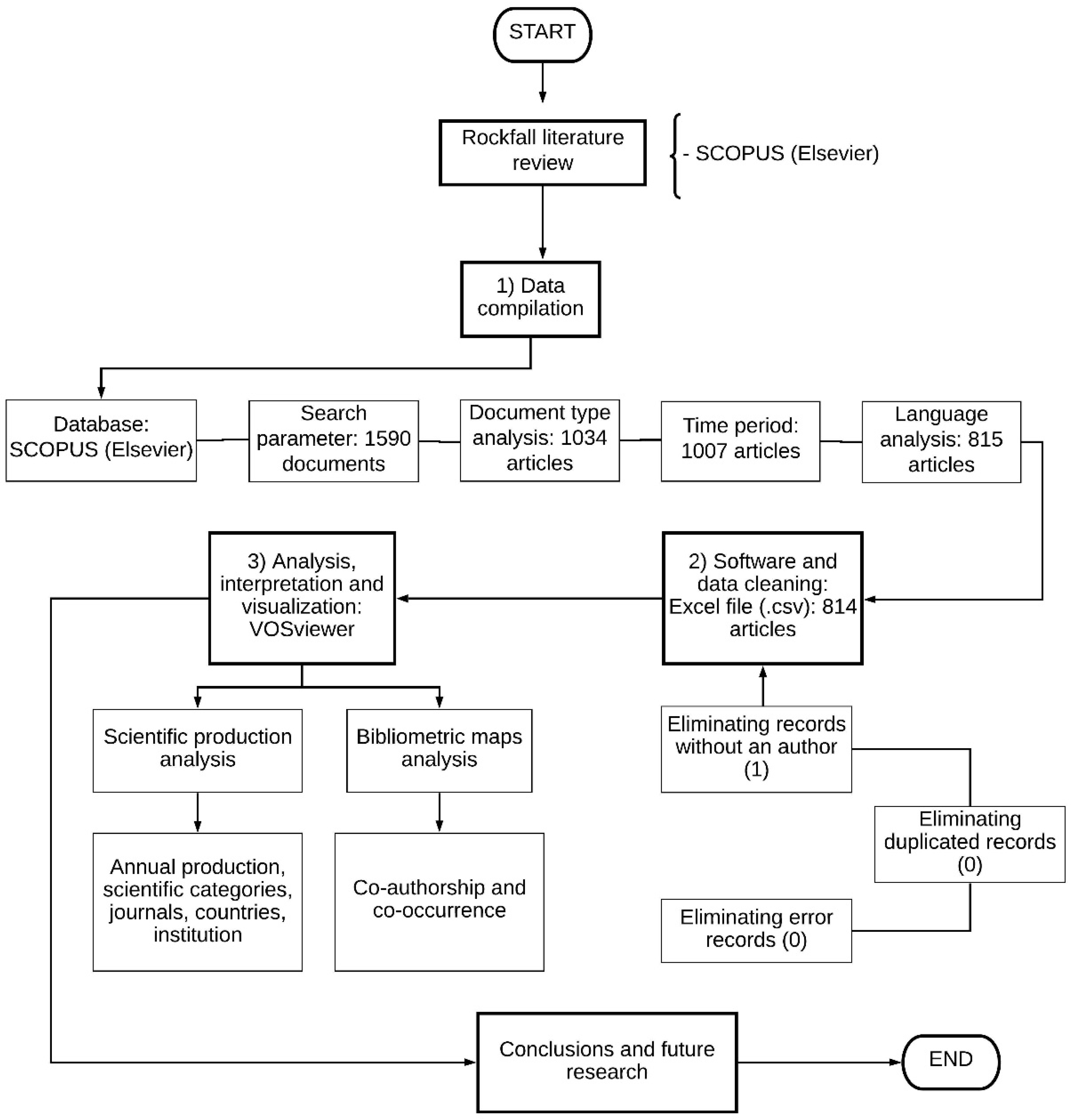
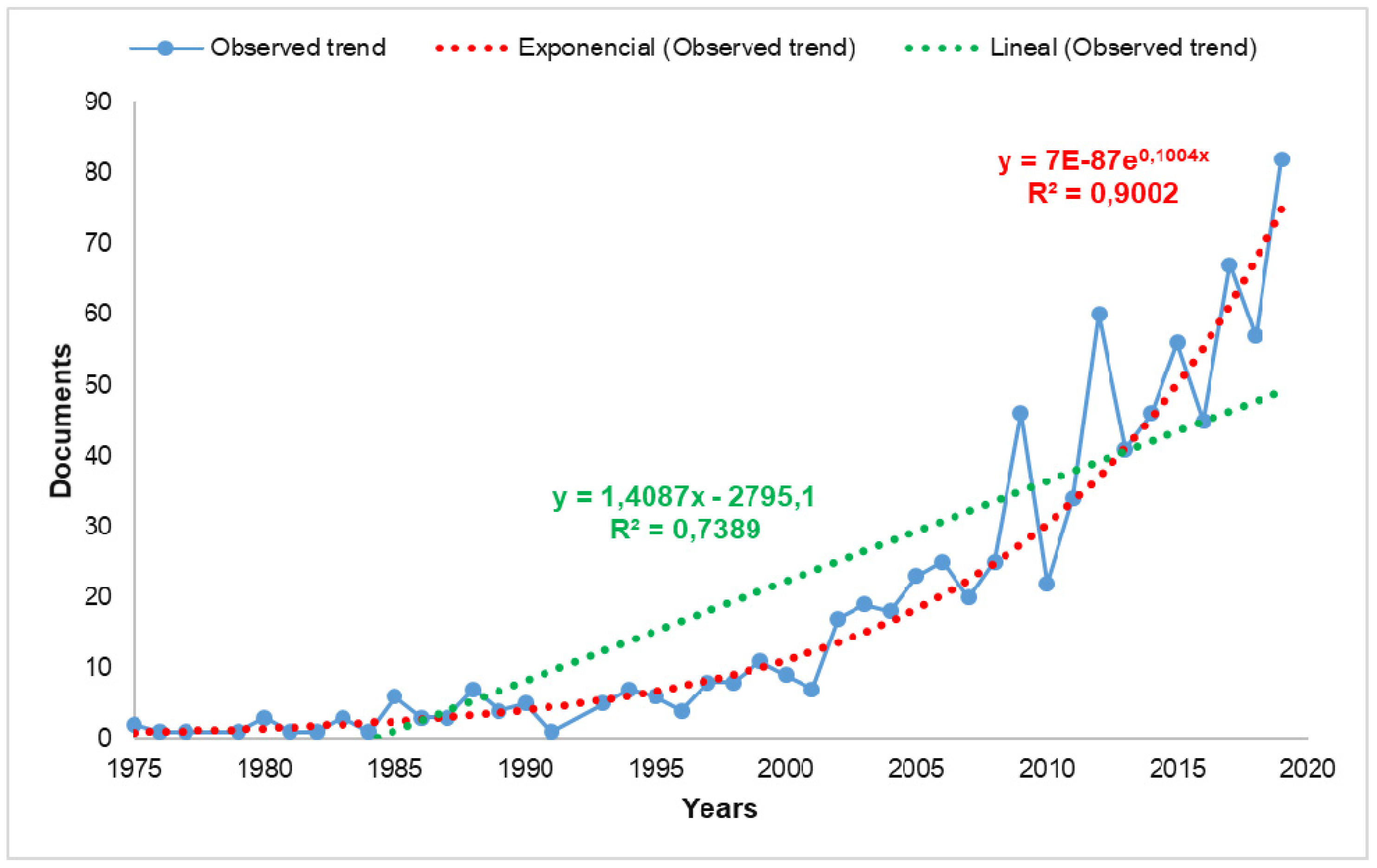
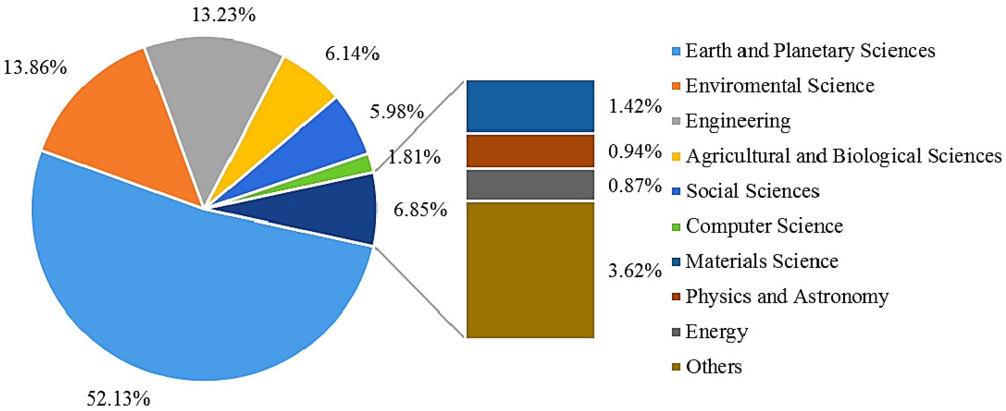
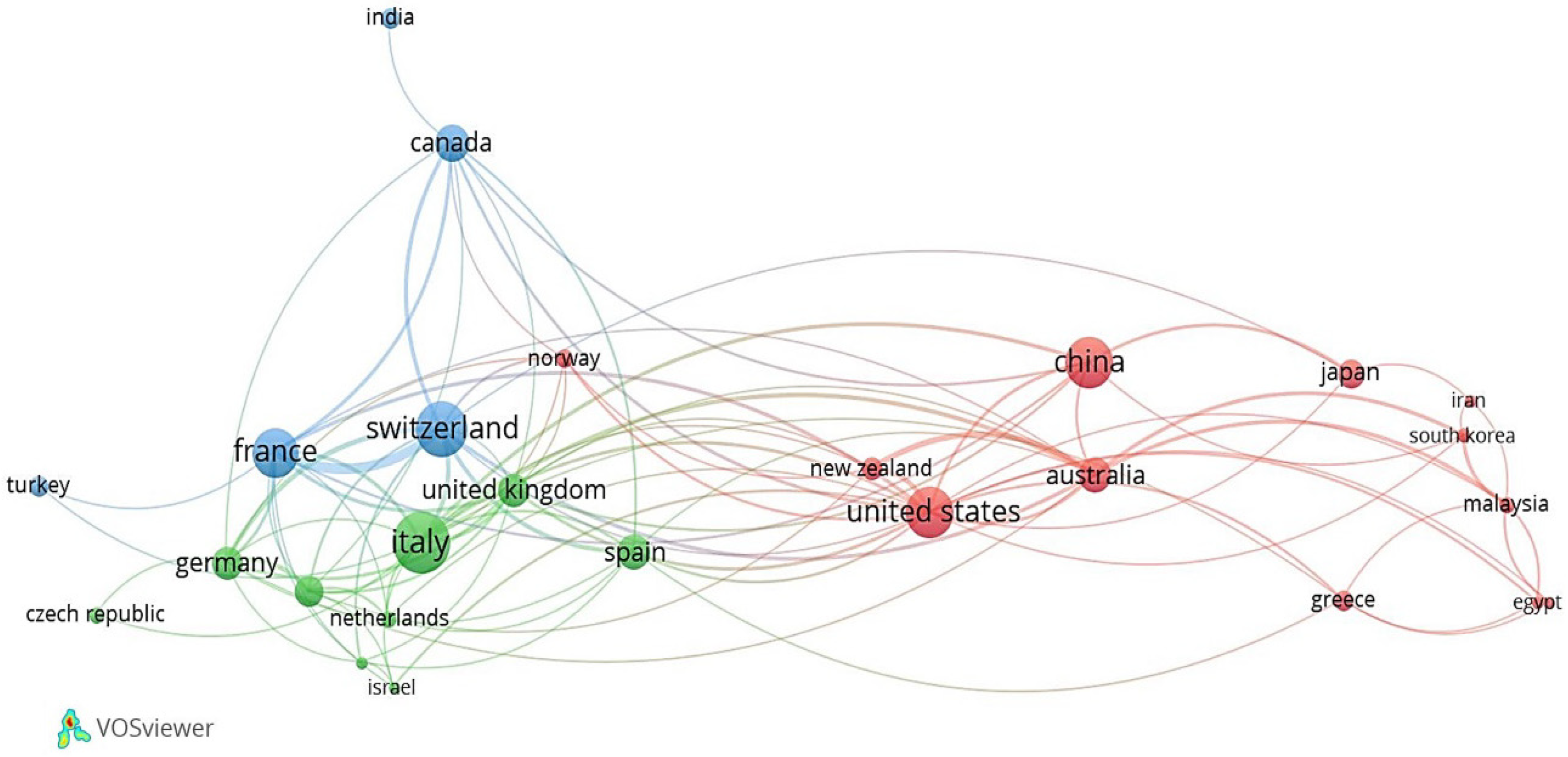
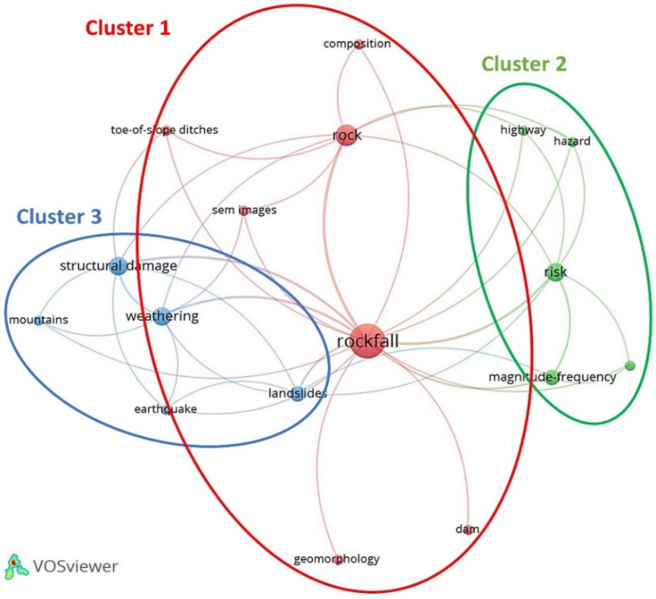
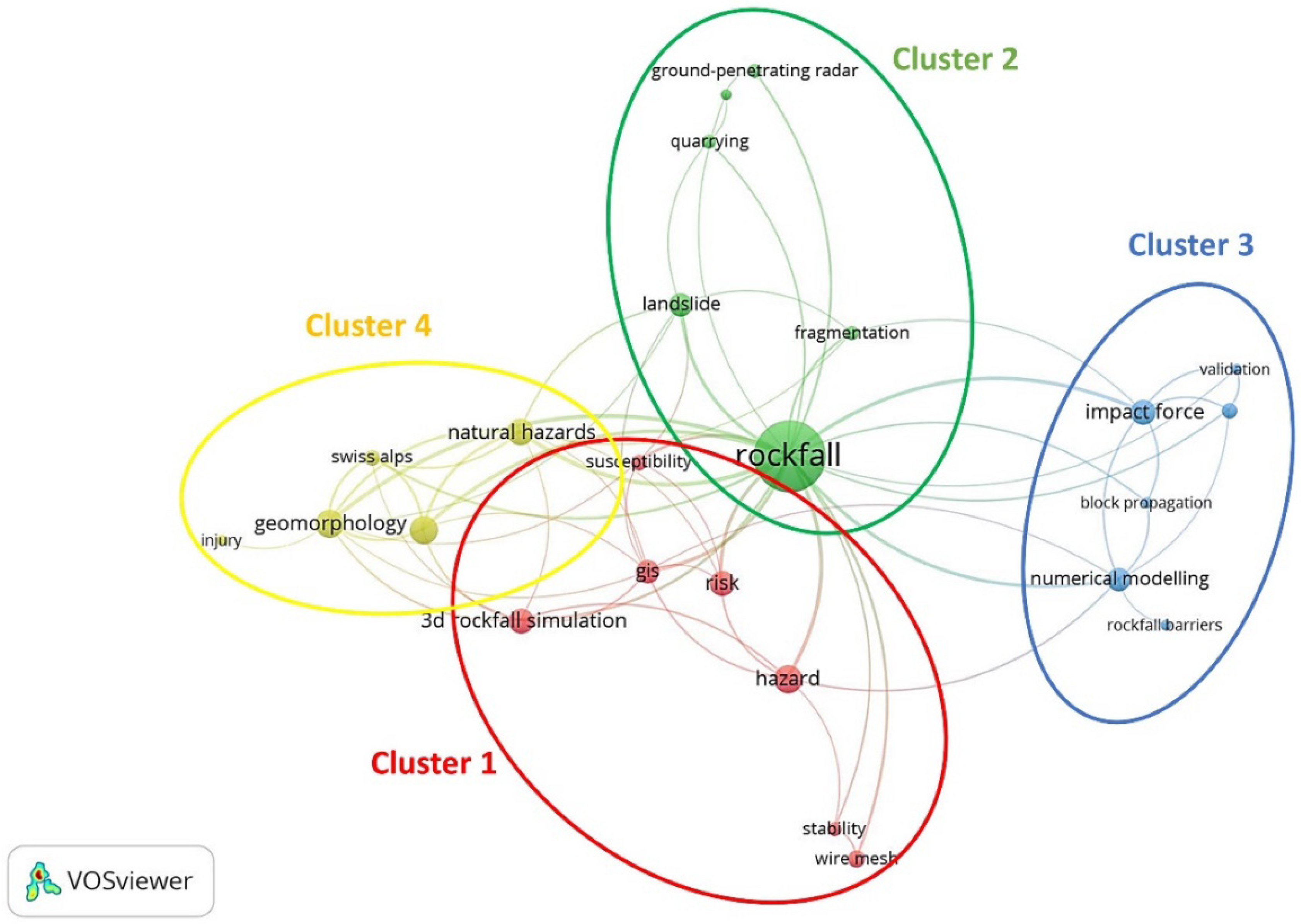
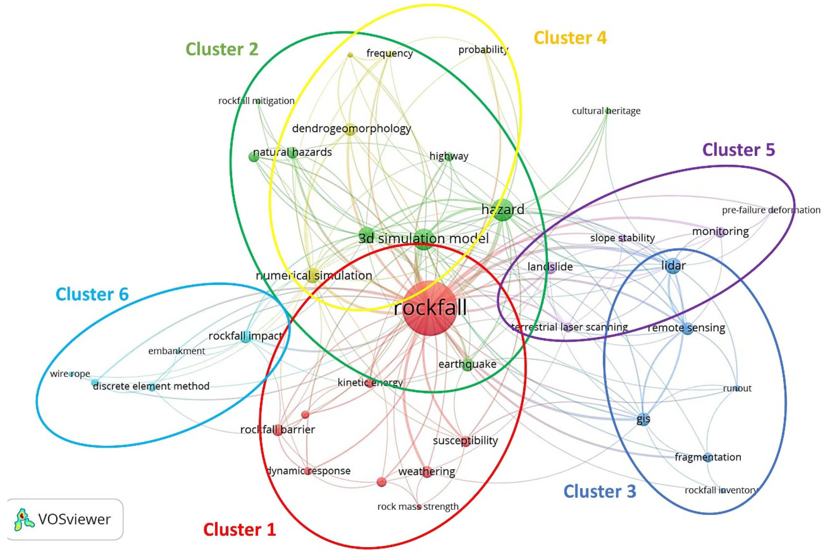
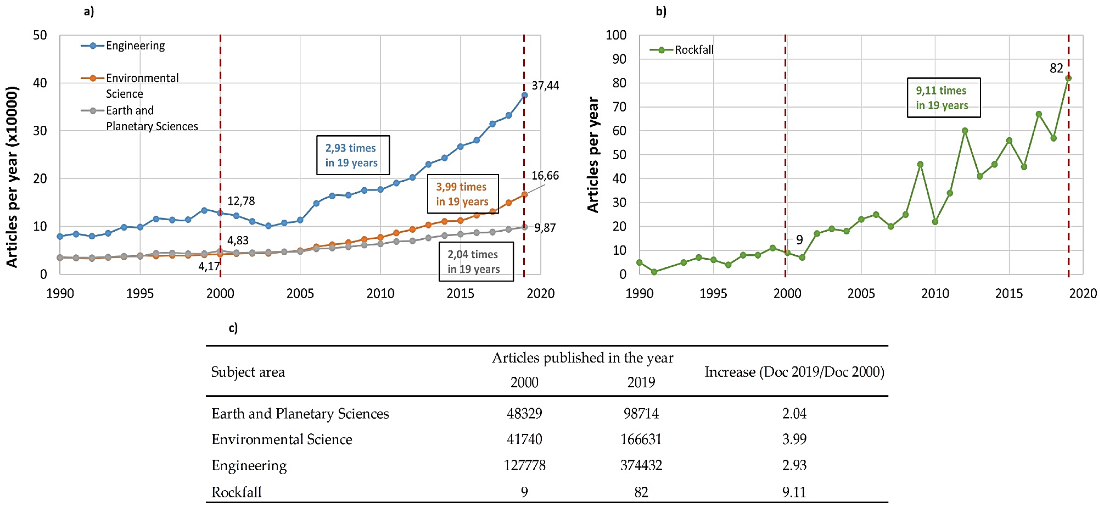
Table 1.
Main characteristics of the phases.
| Phase | Period | TP | %TP | TP/Year | TC | %TC | TC/Year | TC/TP | DC | %DC |
|---|---|---|---|---|---|---|---|---|---|---|
| I | 1975–2001 | 108 | 13.32% | 4.00 | 4398 | 25.35% | 162.89 | 40.72 | 16 | 14.81% |
| II | 2002–2016 | 497 | 61.28% | 33.13 | 12,064 | 69.55% | 804.27 | 24.27 | 40 | 8.05% |
| III | 2017–2019 | 206 | 25.40% | 68.67 | 884 | 5.10% | 294.67 | 4.29 | 57 | 27.67% |
TP: Number of publications; TC: Number of citations; DC: Number of documents without citations.
Table 2.
Scientific production for the top 15 journals.
| Journal | TP | TP% | TC | TC% | TC/TP | Citescore 2018 | SJR |
|---|---|---|---|---|---|---|---|
| Natural Hazards and Earth System Sciences | 76 | 9.34% | 2687 | 15.45% | 35.36 | 3.07 | 1.024 |
| Landslides | 54 | 6.63% | 909 | 5.23% | 16.83 | 4.53 | 1.638 |
| Geomorphology | 41 | 5.04% | 1567 | 9.01% | 38.22 | 3.88 | 1.454 |
| Engineering Geology | 29 | 3.56% | 780 | 4.49% | 26.90 | 4.70 | 2.209 |
| Rock Mechanics and Rock Engineering | 27 | 3.32% | 874 | 5.03% | 32.37 | 5.06 | 2.334 |
| Natural Hazards | 26 | 3.19% | 401 | 2.31% | 15.42 | 2.64 | 0.88 |
| International Journal of Rock Mechanics and Mining Sciences | 21 | 2.58% | 896 | 5.15% | 42.67 | 5.27 | 2.185 |
| Bulletin of Engineering Geology and the Environment | 17 | 2.09% | 117 | 0.67% | 6.88 | 2.37 | 0.839 |
| Environmental Earth Sciences | 17 | 2.09% | 152 | 0.87% | 8.94 | 2.12 | 0.625 |
| Australian Geomechanics Journal | 11 | 1.35% | 16 | 0.09% | 1.45 | 0.49 | 0.348 |
| Canadian Geotechnical Journal | 10 | 1.23% | 747 | 4.30% | 74.70 | 3.00 | 1.753 |
| Engineering Structures | 10 | 1.23% | 103 | 0.59% | 10.30 | 3.77 | 1.628 |
| Environmental and Engineering Geoscience | 10 | 1.23% | 91 | 0.52% | 9.10 | 0.80 | 0.289 |
| Rendiconti Online Societa Geologica Italiana | 10 | 1.23% | 34 | 0.20% | 3.40 | 0.55 | 0.395 |
| Earth Surface Processes and Landforms | 9 | 1.11% | 242 | 1.39% | 26.89 | 3.97 | 1.358 |
TP: Number of publications; TC: Number of citations; TC/TP: average citations per publication.
Table 3.
Scientific production for the top 15 contributing countries.
| Country | TP | TC | TC/TP |
|---|---|---|---|
| Italy | 135 | 3239 | 23.99 |
| Switzerland | 110 | 3355 | 30.50 |
| China | 101 | 1311 | 12.98 |
| United States | 93 | 1980 | 21.29 |
| France | 86 | 2335 | 27.15 |
| Canada | 50 | 1567 | 31.34 |
| Australia | 46 | 473 | 10.28 |
| Spain | 45 | 1347 | 29.93 |
| Germany | 39 | 638 | 16.36 |
| United Kingdom | 38 | 1114 | 29.32 |
| Austria | 33 | 401 | 12.15 |
| Japan | 30 | 625 | 20.83 |
| New Zealand | 19 | 342 | 18.00 |
| Turkey | 17 | 222 | 13.06 |
| Greece | 16 | 260 | 16.25 |
TP: Number of publications; TC: Number of citations; TC/TP: average citations per publication.
Table 4.
The 10 most productive institutions internationally.
| Institution | Country | TP |
|---|---|---|
| Universite Grenoble Alpes | France | 35 |
| INRAE | France | 34 |
| Chinese Academy of Sciences | China | 32 |
| CNRS Centre National de la Recherche Scientifique | France | 26 |
| United States Geological Survey | United States | 26 |
| Université de Genève | Switzerland | 25 |
| Consiglio Nazionale delle Ricerche | Italy | 25 |
| University of Bern | Switzerland | 23 |
| Politecnico di Torino | Italy | 22 |
| Laboratoire des Écosystèmes et des Sociétés en Montagne | France | 22 |
TP: Number of publications.
Table 5.
General citation structure in Rockfall.
| Number of Citations | TP | %TP |
|---|---|---|
| ≥250 citations | 3 | 0.37% |
| ≥100 citations | 29 | 3.56% |
| ≥50 citations | 64 | 7.86% |
| ≥20 citations | 146 | 17.94% |
| ≥5 citations | 274 | 33.66% |
| <5 citations | 298 | 36.61% |
TP: Number of publications; % TP: Percentage of TP.
| Year | Authors | Title | Journal | TC | TC/Year |
|---|---|---|---|---|---|
| 1975 | Hsü K.J. [124] | Catastrophic debris streams (sturzstroms) generated by rockfalls | Bulletin of the Geological Society of America | 589 | 13.09 |
| 1993 | Evans S.G., Hungr O. [32] | The assessment of rockfall hazard at the base of talus slopes | Canadian Geotechnical Journal | 270 | 10.00 |
| 1999 | Hungr O., Evans S.G., Hazzard J. [125] | Magnitude and frequency of rock falls and rock slides along the main transportation corridors of southwestern British Columbia | Canadian Geotechnical Journal | 259 | 12.33 |
| 2003 | Dorren L.K.A. [9] | A review of rockfall mechanics and modeling approaches | Progress in Physical Geography | 219 | 12.88 |
| 2002 | Chau K.T., Wong R.H.C., Wu J.J. [126] | Coefficient of restitution and rotational motions of rockfall impacts | International Journal of Rock Mechanics and Mining Sciences | 208 | 11.55 |
| 2002 | Guzzetti F., Crosta G., Detti R., Agliardi F. [109] | STONE: A computer program for the three-dimensional simulation of rock-falls | Computers and Geosciences | 199 | 11.05 |
| 2009 | Abellán A., Jaboyedoff M., Oppikofer T., Vilaplana J.M. [127] | Detection of millimetric deformation using a terrestrial laser scanner: Experiment and application to a rockfall event | Natural Hazards and Earth System Science | 197 | 17.91 |
| 2003 | Agliardi F., Crosta G.B. [110] | High resolution three-dimensional numerical modeling of rockfalls | International Journal of Rock Mechanics and Mining Sciences | 183 | 10.76 |
| 1999 | Matsuoka N., Sakai H. [11] | Rockfall activity from an alpine cliff during thawing periods | Geomorphology | 179 | 8.52 |
| 1998 | Dade W.B., Huppert H.E. [128] | Long-runout rockfalls | Geology | 176 | 8.00 |
TC: Number of citations; TC/year: Citations per year.
Table 7.
Main authors in Rockfall publications.
| Author | Country | TP | TC | TC/TP | H-Index |
|---|---|---|---|---|---|
| Stoffel, M. | Switzerland | 27 | 973 | 36.04 | 54 |
| Bourrier, F. | France | 21 | 280 | 13.33 | 16 |
| Jaboyedoff, M. | Switzerland | 17 | 676 | 39.76 | 35 |
| Giacomini, A. | Australia | 16 | 422 | 26.38 | 17 |
| Peila, D. | Italy | 15 | 413 | 27.53 | 21 |
| Dorren, L.K.A | Switzerland | 12 | 833 | 69.42 | 18 |
| Berger, F. | France | 11 | 229 | 20.82 | 16 |
| Corona, C. | France | 11 | 129 | 11.73 | 23 |
| Crosta, G. B. | Italy | 11 | 568 | 51.64 | 47 |
| Lambert, S. | France | 10 | 113 | 11.30 | 13 |
TP: Number of publications; TC: Number of citations; TC/TP: average citations per publication.
Table 8.
Author keywords co-occurrence.
| Keyword | Occurrences | Total Link Strength |
|---|---|---|
| Rockfall | 362 | 372 |
| Hazard | 58 | 105 |
| Landslide | 29 | 52 |
| Risk Assessment | 28 | 49 |
| GIS | 25 | 62 |
| Numerical Simulation | 24 | 33 |
| Natural Hazard | 23 | 40 |
| Dendrogeomorphology | 21 | 42 |
| LiDAR | 20 | 47 |
| Impact Force | 18 | 19 |
| Protection Forest | 18 | 26 |
| Earthquake | 13 | 22 |
| Monitoring | 13 | 21 |
| Modeling | 12 | 28 |
| Alps | 11 | 18 |
Table 9.
Cluster groups of the 1990–1999 keyword nodes.
| ID | Cluster | Main Including Labels |
|---|---|---|
| 1 | rockfall-geomorphology | rockfall, rock, composition, dam, geomorphology, SEM images, toe-of-slope ditches |
| 2 | hazard-risk | risk, magnitude-frequency, coefficient of restitution, hazard, highway |
| 3 | natural hazards | weathering, structural damage, landslides, earthquake, mountains |
Table 10.
Cluster groups of the 2000–2009 keyword nodes.
| ID | Clusters | Main Including Labels |
|---|---|---|
| 1 | hazard-risk | hazard, 3D rockfall simulation, risk, GIS, wire mesh, susceptibility, stability |
| 2 | rockfall monitoring | rockfall, landslide, fragmentation, terrestrial laser scanner, ground-penetrating radar, quarrying, monitoring |
| 3 | numerical modeling | numerical modeling, impact force, rock mechanics, block propagation, rockfall barrier, validation |
| 4 | natural hazards | geomorphology, protection forest, natural hazards, swiss alps, injury |
Table 11.
Cluster groups of the 2010–2019 keyword nodes.
| ID | Clusters | Main Including Labels |
|---|---|---|
| 1 | rockfall monitoring | rockfall, rockfall barrier, weathering, susceptibility, failure mechanism, kinetic energy, coefficient of restitution, dynamic response, rock mass strength |
| 2 | 3D simulation model | 3D simulation model, hazard, risk assessment, earthquake, natural hazards, protection forest, highway, cultural heritage, rockfall mitigation |
| 3 | remote sensing | remote sensing, LiDAR, photogrammetry, GIS, fragmentation, runout, rockfall inventory |
| 4 | numerical modeling | numerical simulation, dendrogeomorphology, frequency, probability, mass movement |
| 5 | slope stability | monitoring, landslide, terrestrial laser scanning, slope stability, pre-failure deformation |
| 6 | rockfall impact | rockfall impact, discrete element method, energy dissipation, embankment, wire rope |
Table 12.
Topic clusters of rockfall research 1975–2019.
| Topic # | Clusters | Top 5 Terms | 2010–2019 | 2000–2009 | 1990–1999 | |||
|---|---|---|---|---|---|---|---|---|
| # Terms | Share | # Terms | Share | # Terms | Share | |||
| 1 | rockfall-geomorphology | rockfall, rock, composition, dam, geomorphology | 0 | 0.00% | shifted to #5 | 0.00% | 19 | 54.29% |
| 2 | hazard-risk | risk, magnitude-frequency, coefficient of restitution, hazard, highway | 0 | 0.00% | shifted to #4 | 0.00% | 8 | 22.86% |
| 3 | natural hazards | weathering, structural damage, landslides, earthquake, mountains | 0 | 0.00% | shifted to #7 | 0.00% | 8 | 22.86% |
| 4 | hazard-risk | hazard, 3D rockfall simulation, risk, GIS, wire mesh | shifted to #8 and #10 | 0.00% | 51 | 23.83% | 0 | 0.00% |
| 5 | rockfall monitoring | rockfall, landslide, fragmentation, terrestrial laser scanner, ground-penetrating radar | shifted to #8 and 10 | 0.00% | 94 | 43.93% | 0 | 0.00% |
| 6 | numerical modeling | numerical modeling, impact force, rock mechanics, block propagation, rockfall barrier | shifted to #11 | 0.00% | 28 | 13.08% | 0 | 0.00% |
| 7 | natural hazards | geomorphology, protection forest, natural hazards, swiss alps, injury | shifted to #9 | 0.00% | 41 | 19.16% | 0 | 0.00% |
| 8 | rockfall monitoring | rockfall, rockfall barrier, weathering, susceptibility, failure mechanism | 348 | 47.80% | 0 | 0.00% | 0 | 0.00% |
| 9 | 3D simulation model | 3D simulation model, hazard, risk assessment, earthquake, natural hazards | 174 | 23.90% | 0 | 0.00% | 0 | 0.00% |
| 10 | remote sensing | remote sensing, LiDAR, photogrammetry, GIS, fragmentation | 73 | 10.03% | 0 | 0.00% | 0 | 0.00% |
| 11 | numerical modeling | numerical simulation, dendrogeomorphology, frequency, probability, mass movement | 50 | 6.87% | 0 | 0.00% | 0 | 0.00% |
| 12 | slope stability | monitoring, landslide, terrestrial laser scanning, slope stability, pre-failure deformation | 47 | 6.46% | 0 | 0.00% | 0 | 0.00% |
| 13 | rockfall impact | rockfall impact, discrete element method, energy dissipation, embankment, wire rope | 36 | 4.95% | 0 | 0.00% | 0 | 0.00% |
| 728 | 100.00% | 214 | 100% | 35 | 100% | |||
Table 13.
Variation author keywords in 1990–1999, 2000–2009, and 2010–2019 stages.
| Author Keyword 1990–1999 | Co-Occurrence | Author Keyword 2000–2009 | Co-Occurrence | Author Keyword 2010–2019 | Co-Occurrence |
|---|---|---|---|---|---|
| rockfall | 10 | rockfall | 75 | rockfall | 276 |
| rock | 4 | geomorphology | 12 | hazard | 46 |
| risk | 3 | hazard | 12 | 3D simulation model | 45 |
| structural damage | 3 | protection forest | 12 | risk assessment | 26 |
| weathering | 3 | natural hazards | 11 | LiDAR | 25 |
| landslides | 2 | 3D rockfall simulation | 10 | numerical simulation | 22 |
| magnitude-frequency | 2 | impact force | 10 | GIS | 17 |
| coefficient of restitution | 1 | risk | 9 | earthquake | 16 |
| composition | 1 | GIS | 8 | landslide | 16 |
| dam | 1 | landslide | 8 | dendrogeomorphology | 15 |
| earthquake | 1 | numerical modeling | 8 | remote sensing | 15 |
| geomorphology | 1 | wire mesh | 5 | rockfall impact | 15 |
| hazard | 1 | rock mechanics | 4 | natural hazards | 14 |
| highway | 1 | susceptibility | 4 | rockfall barrier | 14 |
| mountains | 1 | swiss alps | 4 | weathering | 14 |
© 2020 by the authors. Licensee MDPI, Basel, Switzerland. This article is an open access article distributed under the terms and conditions of the Creative Commons Attribution (CC BY) license (http://creativecommons.org/licenses/by/4.0/).
Share and Cite
MDPI and ACS Style
Briones-Bitar, J.; Carrión-Mero, P.; Montalván-Burbano, N.; Morante-Carballo, F. Rockfall Research: A Bibliometric Analysis and Future Trends. Geosciences 2020, 10, 403. https://0-doi-org.brum.beds.ac.uk/10.3390/geosciences10100403
AMA Style
Briones-Bitar J, Carrión-Mero P, Montalván-Burbano N, Morante-Carballo F. Rockfall Research: A Bibliometric Analysis and Future Trends. Geosciences. 2020; 10(10):403. https://0-doi-org.brum.beds.ac.uk/10.3390/geosciences10100403
Chicago/Turabian StyleBriones-Bitar, Josué, Paúl Carrión-Mero, Néstor Montalván-Burbano, and Fernando Morante-Carballo. 2020. "Rockfall Research: A Bibliometric Analysis and Future Trends" Geosciences 10, no. 10: 403. https://0-doi-org.brum.beds.ac.uk/10.3390/geosciences10100403
Note that from the first issue of 2016, this journal uses article numbers instead of page numbers. See further details here.