Features That Favor the Prediction of the Emplacement Location of Maar Volcanoes: A Case Study in the Central Andes, Northern Chile


Abstract
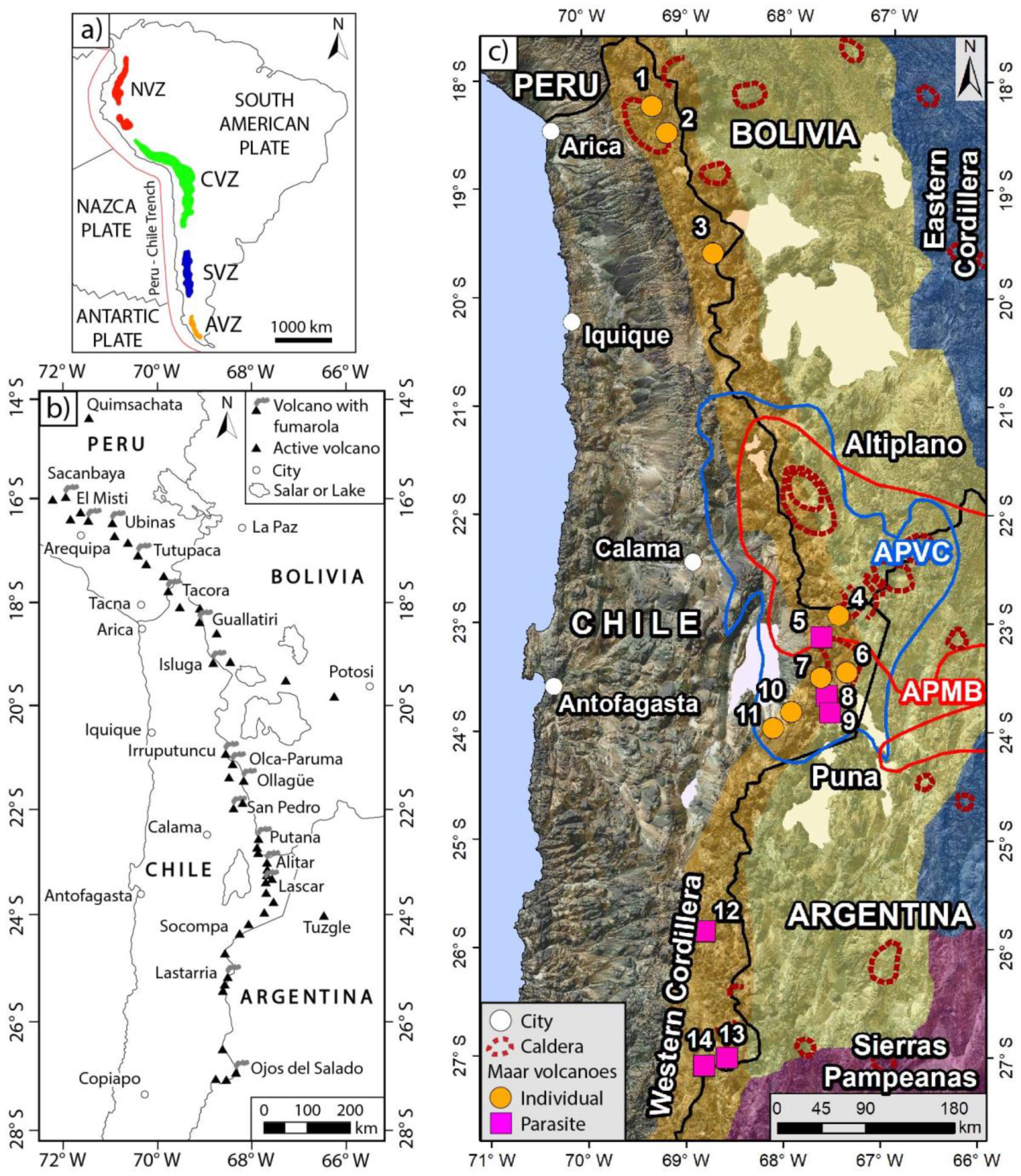
:1. Introduction
2. Geological and Volcanological Setting
3. Case Studies
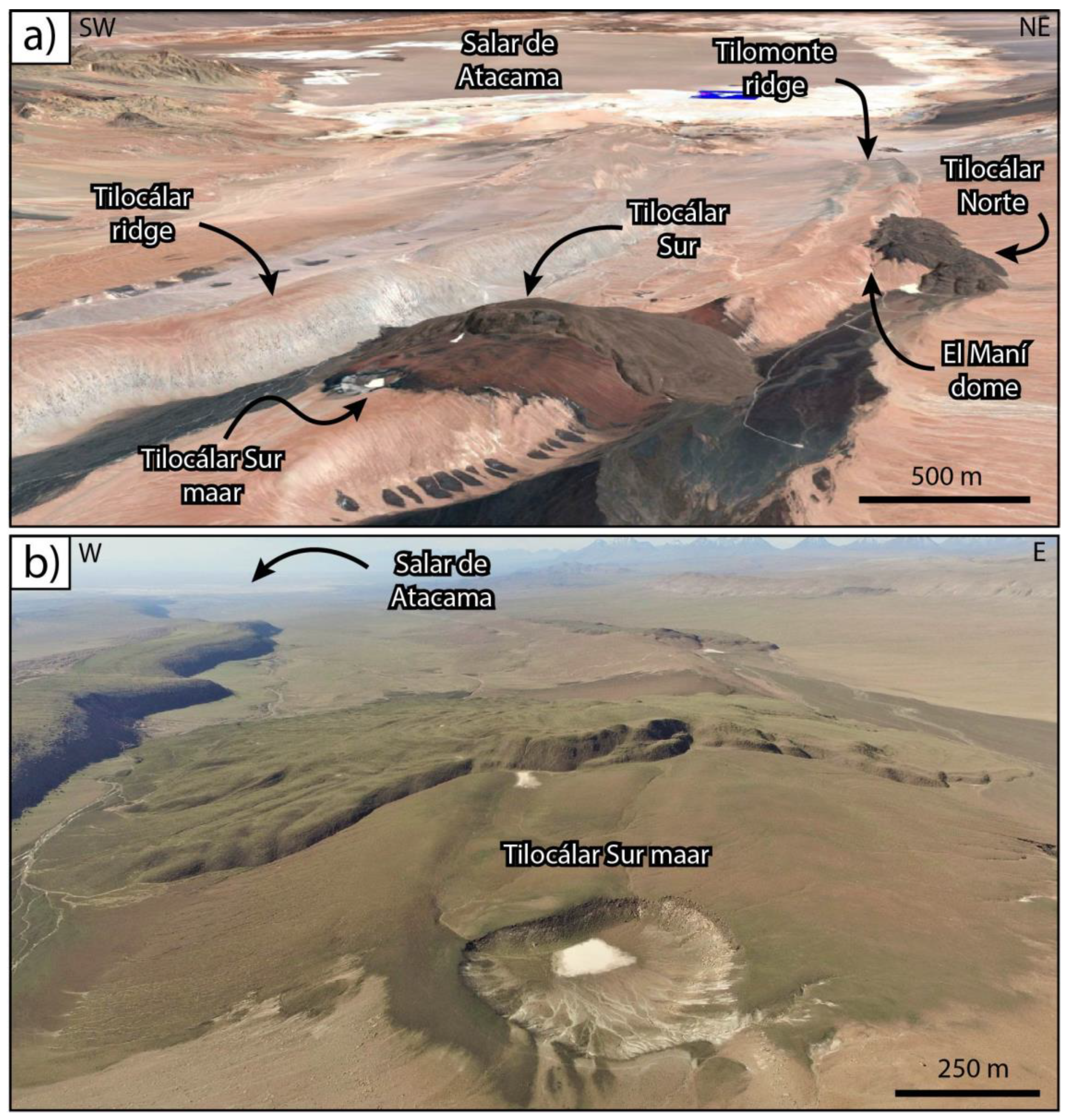
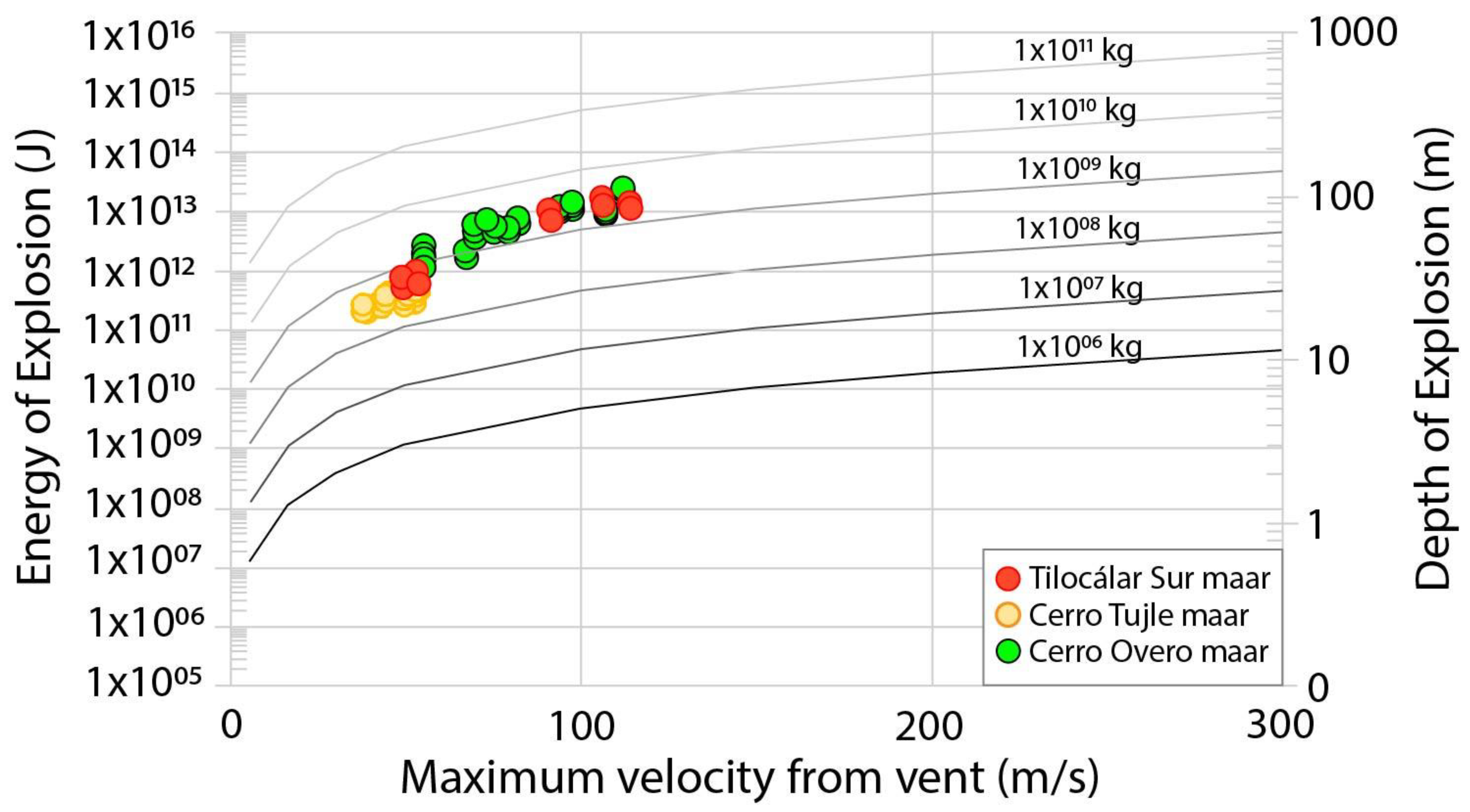
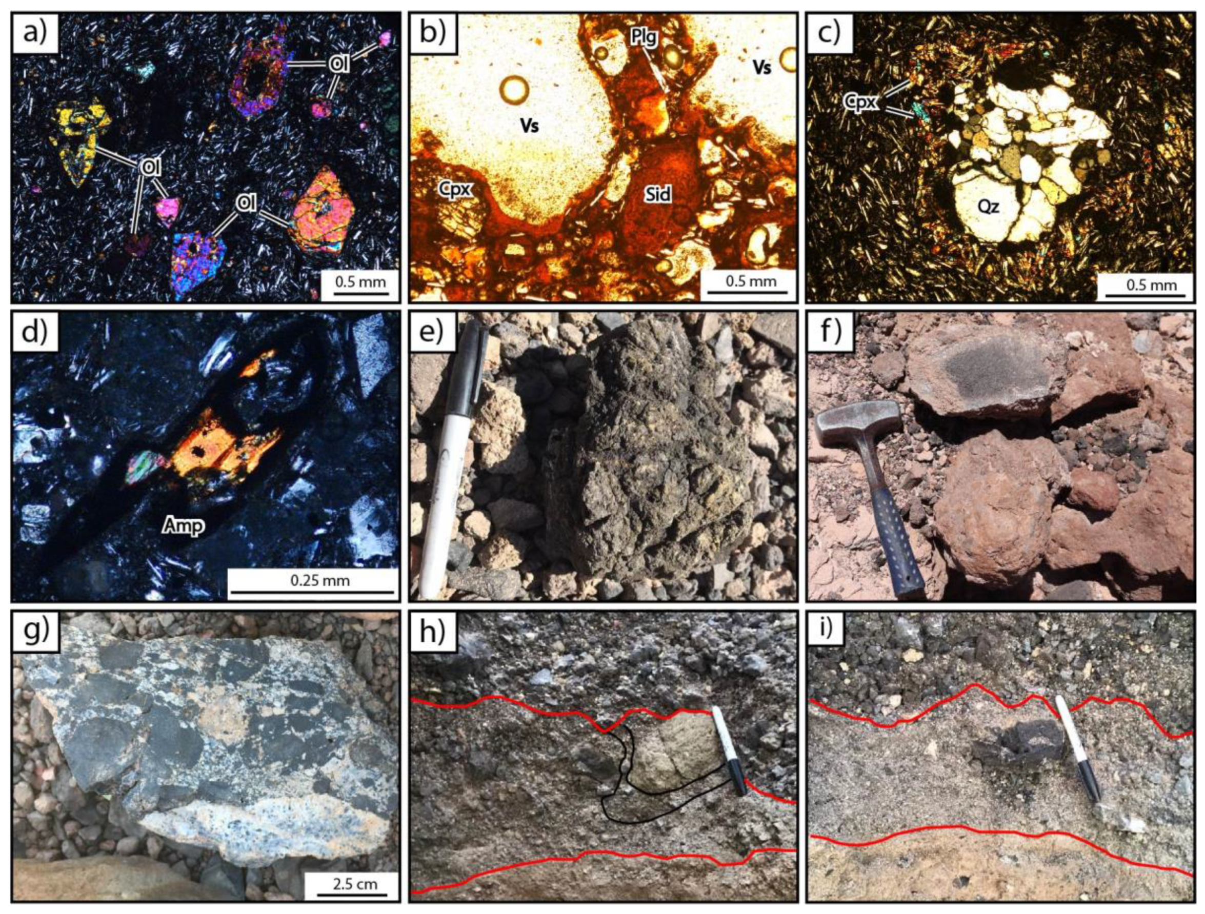
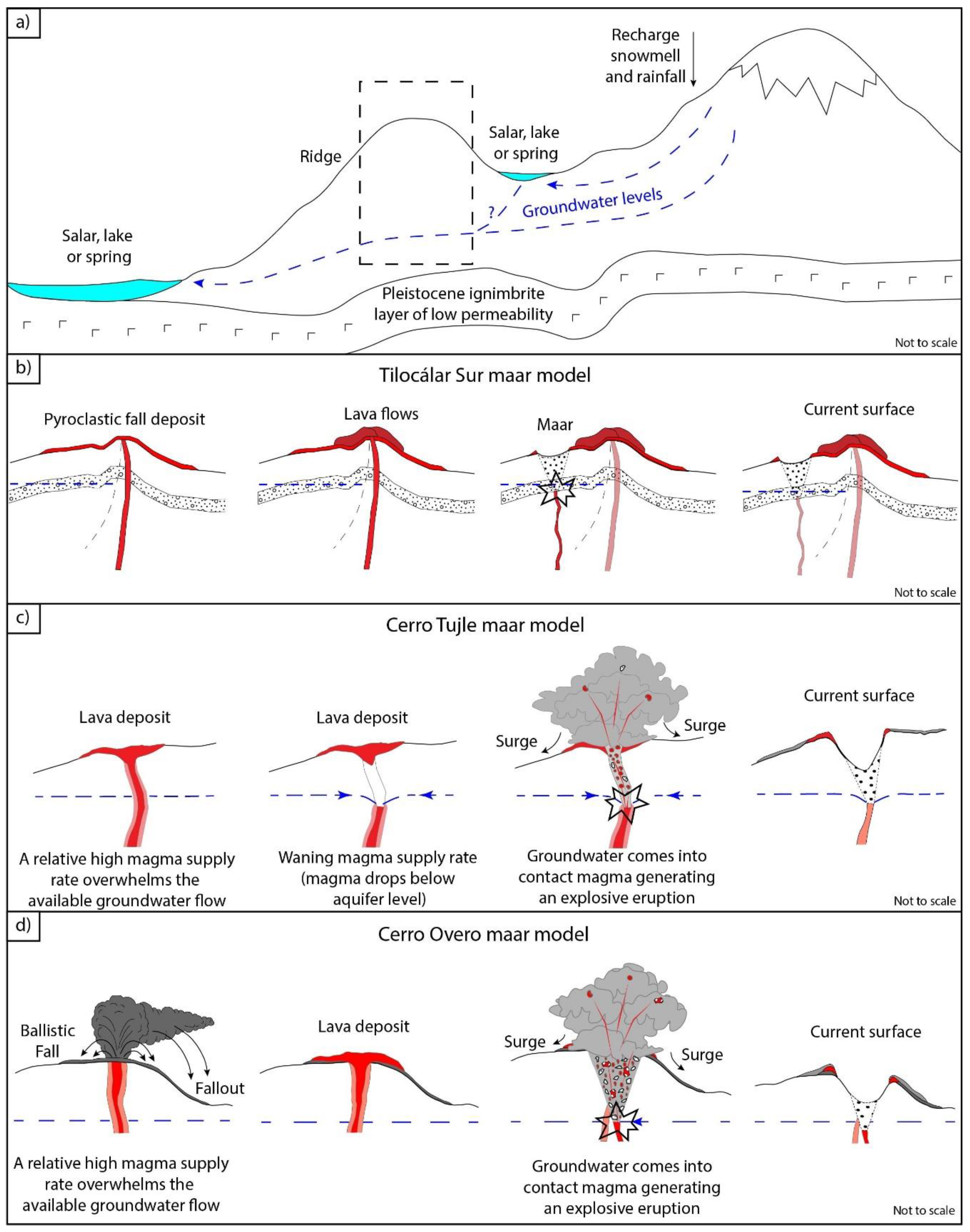
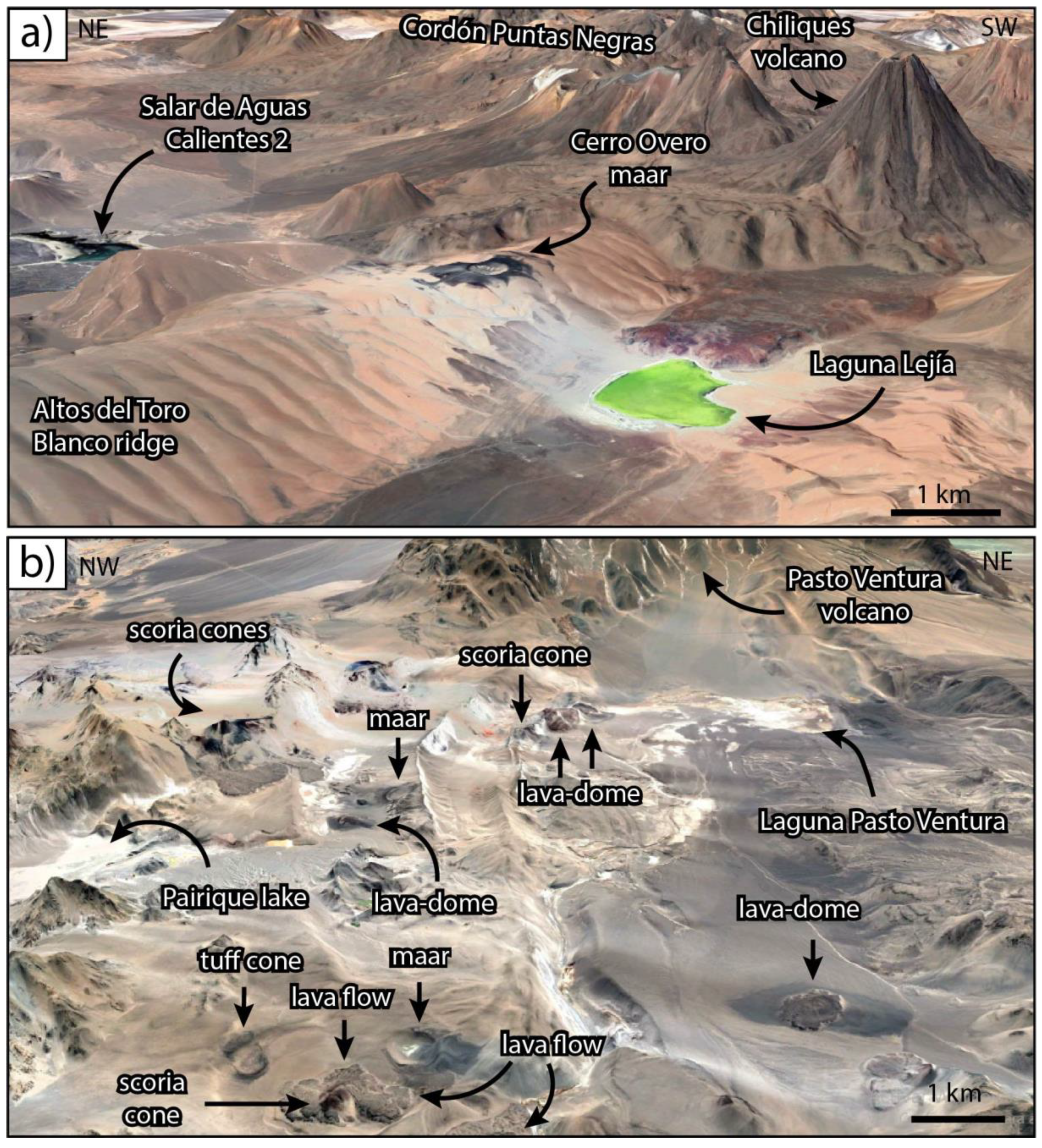
3.1. Tilocálar Sur Maar
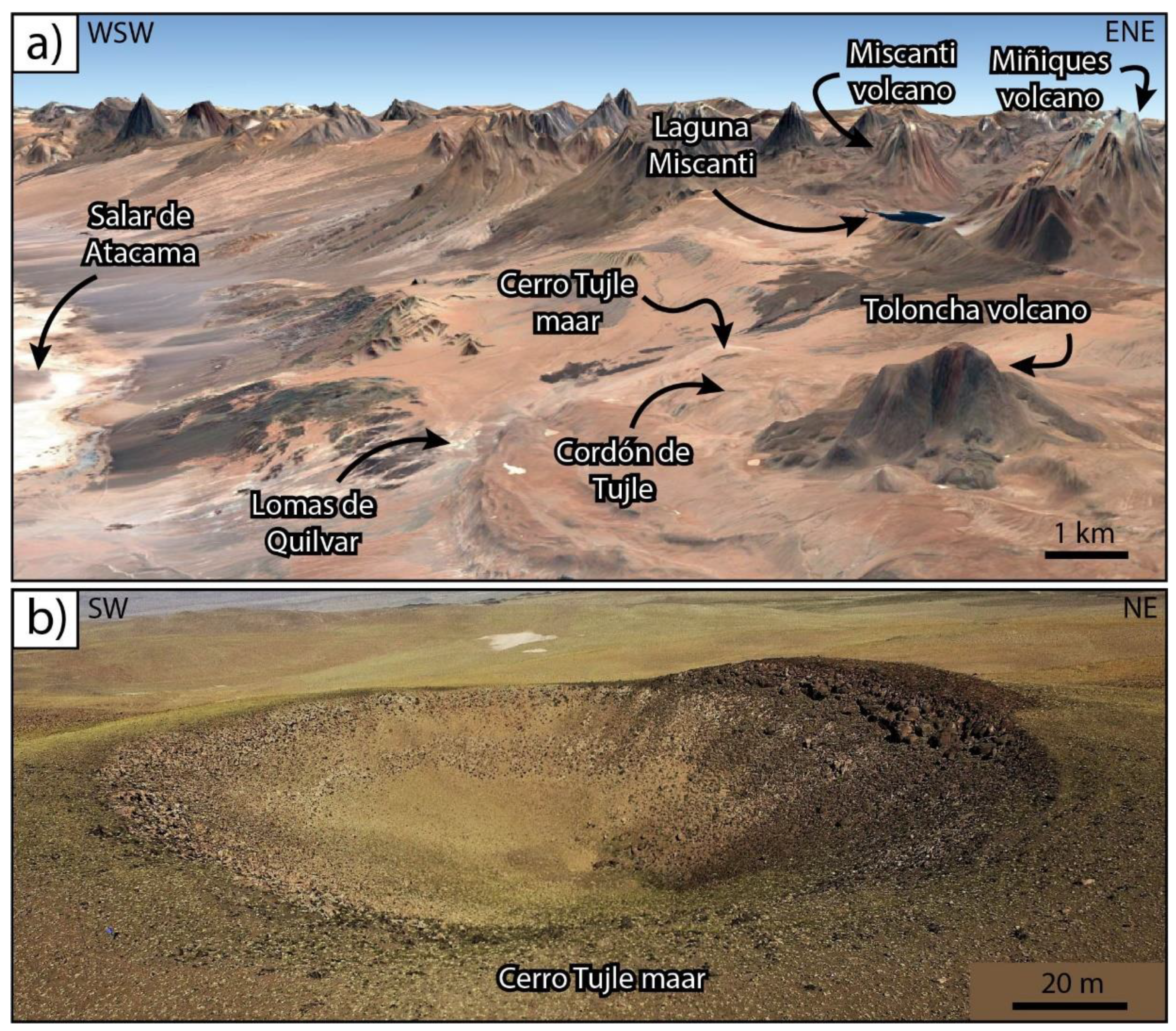
3.2. Cerro Tujle Maar
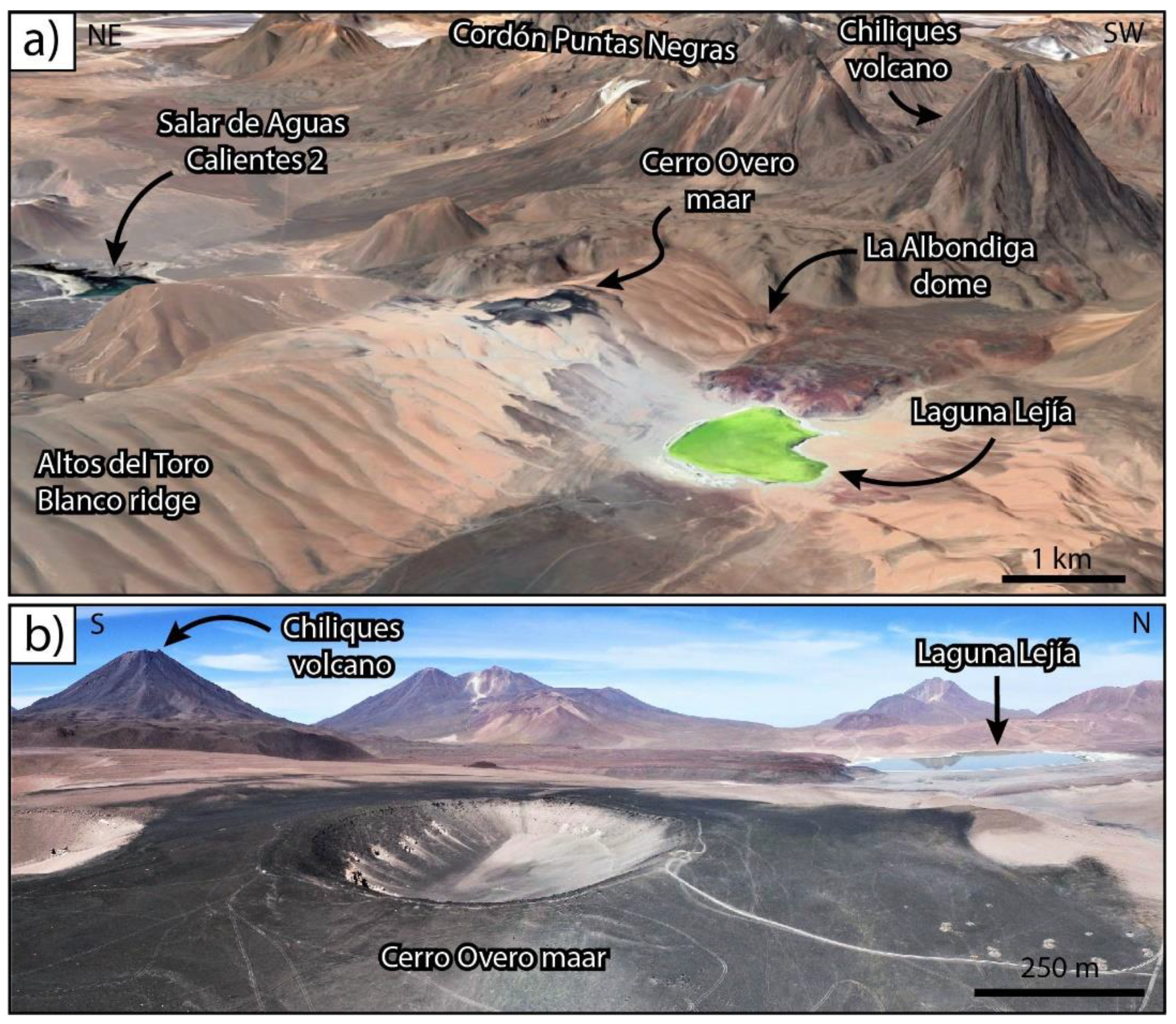
3.3. Cerro Overo Maar
4. Discussion
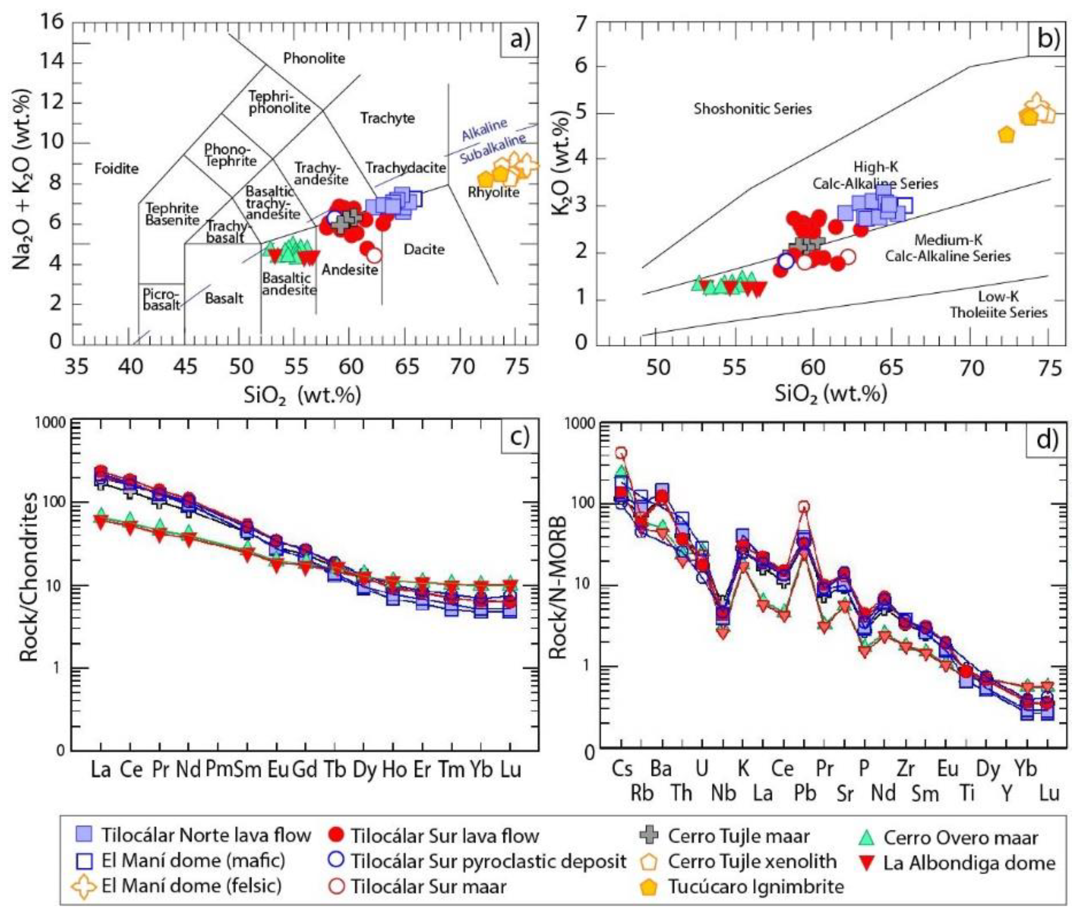
4.1. Origin of the Phreatomagmatism
4.2. The Role of the Eruption Location on Water Availability
4.3. Eruption Styles
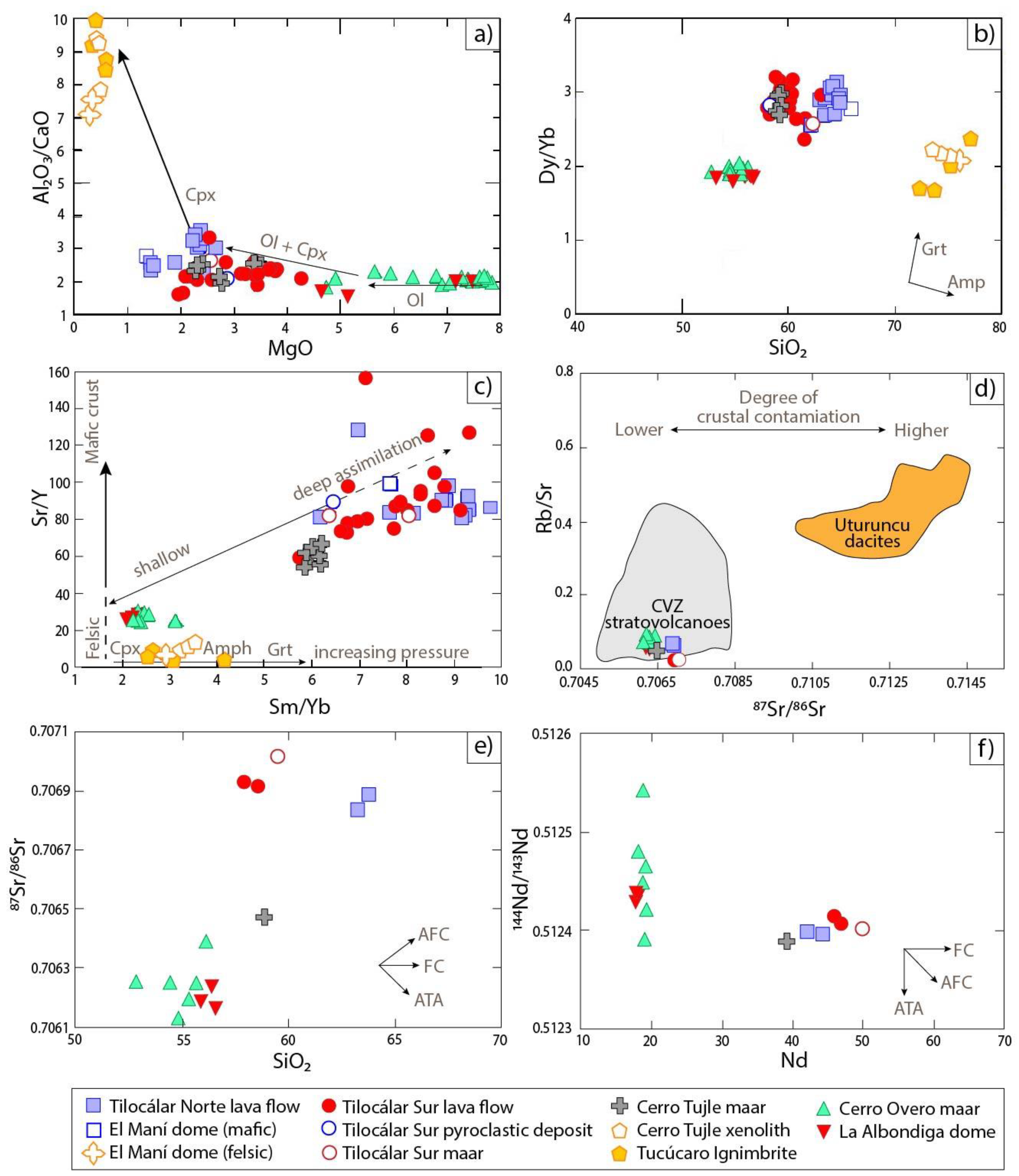
4.4. Magmatic Processes
4.5. Proposed Model
- A compressive tectonic setting, which generates folding systems represented by ridges structures forming a planar pathway at a shallow depth being auspicious for reservoirs (e.g., [75]) as groundwater tables. This tectonic setting generates the appropriate structural conditions to favor and form the space for groundwater channels that can host lenses of water bodies.
- The lithological setting, characterized by alluvial sediments of variable thickness, overlying fractured andesitic lavas, large ignimbritic deposits, and erosional or weathered interlayered volcanic deposits (e.g., [44,48]). The large ignimbrite sheets are commonly extensively welded and/or hydrothermally altered, displaying layers of low permeability and permeable volcanic-derived sediments [88]. They form a regional groundwater flow base dipping gently away from their respective sources that do not follow the present-day topography marked by complex medium-volume stratovolcanic cone caps [85,86]. Besides, these extensive Pleistocene ignimbrite sheets are relatively shallow beneath cover beds, especially in areas between major stratovolcanoes. In those inter-cone areas, they are covered by debris fans that commonly shed run-off towards local lowlands that functioned as large but shallow lakes in pluvial periods (today, they are salars).
- The presence of aquifer and/or endorheic basins (e.g., lakes or salars), in the Altiplano area, which demonstrates the occurrence of groundwater flows among closed basins, which provide the hydraulic connection between groundwater levels (e.g., [85]).
- A period of stress relaxation, although the Altiplano-Puna is dominated by a compressional tectonic setting, monogenetic volcanism has been associated with local extension permitting the magma to ascend to the surface (e.g., [140]).
5. Concluding Remarks
Author Contributions
Funding
Acknowledgments
Conflicts of Interest
References
- Vespermann, D.; Schmincke, H.-U. Scoria cones and tuff rings. In Encyclopedia of Volcanoes; Sigurdsson, H., Houghton, B., McNutt, S., Rymer, H., Stix, J., Eds.; Academic Press: Cambridge, MA, USA, 2000; pp. 683–694. [Google Scholar]
- Lorenz, V. Syn- and posteruptive hazards of maar–diatreme volcanoes. J. Volcanol. Geotherm. Res. 2007, 159, 285–312. [Google Scholar] [CrossRef]
- Graettinger, A.H. Trends in maar crater size and shape using the global Maar Volcano Location and Shape (MaarVLS) database. J. Volcanol. Geotherm. Res. 2018, 357, 1–13. [Google Scholar] [CrossRef] [Green Version]
- Lorenz, V. On the formation of maars. Bull. Volcanol. 1973, 37, 183–204. [Google Scholar] [CrossRef]
- White, J.D.L.; Ross, P.S. Maar-diatreme volcanoes: A review. J. Volcanol. Geotherm. Res. 2011, 201, 1–29. [Google Scholar] [CrossRef] [Green Version]
- Valentine, G.A.; White, J.D.L. Revised conceptual model for maar-diatremes: Subsurface processes, energetics, and eruptive products. Geology 2012, 40, 1111–1114. [Google Scholar] [CrossRef]
- Ross, P.-S.; Carrasco Núñez, G.; Hayman, P. Felsic maar-diatreme volcanoes: A review. Bull. Volcanol. 2017, 79. [Google Scholar] [CrossRef]
- Lorenz, V. Maars and diatremes of phreatomagmatic origin; a review. S. Afr. J. Geol. 1985, 88, 459–470. [Google Scholar]
- Lorenz, V. On the growth of maars and diatremes and its relevance to the formation of tuff rings. Bull. Volcanol. 1986, 48, 265–274. [Google Scholar] [CrossRef]
- Lorenz, V.; Suhr, P.; Suhr, S. Phreatomagmatic maar-diatreme volcanoes and their incremental growth: A model. Geol. Soc. Lond. Spec. Publ. 2016, 446, 29–59. [Google Scholar] [CrossRef]
- Kereszturi, G.; Németh, K. Monogenetic Basaltic Volcanoes: Genetic Classification, Growth, Geomorphology and Degradation. In Updates in Volcanology-New Advances in Understanding Volcanic Systems; Németh, K., Ed.; Intech Open: London, UK, 2012; Chapter 1; pp. 3–88. [Google Scholar]
- Németh, K.; Kereszturi, G. Monogenetic volcanism: Personal views and discussion. Int. J. Earth Sci. 2015, 104, 2131–2146. [Google Scholar] [CrossRef]
- Smith, I.E.M.; Németh, K. Source to surface model of monogenetic volcanism: A critical review. In Monogenetic Volcanism; Németh, K., Carrasco-Núñez, G., Aranda-Gómez, J.J., Smith, I.E.M., Eds.; Geological Society: London, UK, 2017; Volume 446, Chapter 1; pp. 1–28. [Google Scholar]
- Németh, K. Monogenetic volcanic fields: Origin, sedimentary record, and relationship with polygenetic volcanism. In What Is a Volcano? Canon-Tapia, E., Szakacs, A., Eds.; Geological Society of America: Boulder, CO, USA, 2010; Volume 470, pp. 43–66. [Google Scholar]
- Németh, K.; Kósik, S. Review of Explosive Hydrovolcanism. Geosciences 2020, 10, 44. [Google Scholar] [CrossRef] [Green Version]
- Németh, K.; Kósik, S. The role of hydrovolcanism in the formation of the Cenozoic monogenetic volcanic fields of Zealandia. N. Z. J. Geol. Geophys. 2020, 1–26. [Google Scholar] [CrossRef]
- Valentine, G.A.; White, J.D.L.; Ross, P.-S.; Amin, J.; Taddeucci, J.; Sonder, I.; Johnson, P.J. Experimental craters formed by single and multiple buried explosions and implications for volcanic craters with emphasis on maars. Geophys. Res. Lett. 2012, 39. [Google Scholar] [CrossRef]
- Valentine, G.A.; White, J.D.L.; Ross, P.-S.; Graettinger, A.H.; Sonder, I. Updates to Concepts on Phreatomagmatic Maar-Diatremes and Their Pyroclastic Deposits. Front. Earth Sci. 2017, 5. [Google Scholar] [CrossRef]
- Bishop, M.A. A generic classification for the morphological and spatial complexity of volcanic (and other) landforms. Geomorphology 2009, 111, 104–109. [Google Scholar] [CrossRef]
- Kósik, S.; Németh, K.; Lexa, J.; Procter, J.N. Understanding the evolution of a small-volume silicic fissure eruption: Puketerata Volcanic Complex, Taupo Volcanic Zone, New Zealand. J. Volcanol. Geotherm. Res. 2019, 383, 28–46. [Google Scholar] [CrossRef]
- Murcia, H.; Németh, K.; El-Masry, N.N.; Lindsay, J.M.; Moufti, M.R.H.; Wameyo, P.; Cronin, S.J.; Smith, I.E.M.; Kereszturi, G. The Al-Du’aythah volcanic cones, Al-Madinah City: Implications for volcanic hazards in northern Harrat Rahat, Kingdom of Saudi Arabia. Bull. Volcanol. 2015, 77, 54. [Google Scholar] [CrossRef]
- Gutmann, J.T. Geology of Crater Elegante, Sonora, Mexico. Gsa Bull. 1976, 87, 1718–1729. [Google Scholar] [CrossRef]
- Gutmann, J.T. Strombolian and effusive activity as precursors to phreatomagmatism: Eruptive sequence at maars of the Pinacate volcanic field, Sonora, Mexico. J. Volcanol. Geotherm. Res. 2002, 113, 345–356. [Google Scholar] [CrossRef]
- Decker, R.W.; Christiansen, R.L. Explosive Eruptions of Kilauea Volcano, Hawaii; National Academy Press: Washington, DC, USA, 1984; p. 12. [Google Scholar]
- Swanson, D.; Fiske, D.; Rose, T.; Houghton, B.; Mastin, L. Kïlauea—An Explosive Volcano in Hawai ‘i. U. S. Geol. Surv. 2011, 4. [Google Scholar] [CrossRef] [Green Version]
- Houghton, B.; White, J.D.L.; Van Eaton, A.R. Phreatomagmatic and Related Eruption Styles. In The Encyclopedia of Volcanoes, 2nd ed.; Sigurdsson, H., Houghton, B., McNutt, S.R., Rymer, H., Stix, J., Eds.; Academic Press: Cambridge, MA, USA, 2015; pp. 537–552. [Google Scholar]
- Németh, K. The morphology and origin of wide craters at Al Haruj al Abyad, Libya: Maars and phreatomagmatism in a large intracontinental flood lava field? Z. Für Geomorphol. 2004, 48, 417–439. [Google Scholar]
- Báez, W.; Carrasco Nuñez, G.; Giordano, G.; Viramonte, J.G.; Chiodi, A. Polycyclic scoria cones of the Antofagasta de la Sierra basin, Southern Puna plateau, Argentina. In Monogenetic Volcanism; Németh, K., Carrasco-Núñez, G., Aranda-Gómez, J.J., Smith, I.E.M., Eds.; Geological Society: London, UK, 2017; Volume 446, Chapter 311; pp. 311–336. [Google Scholar]
- Sweeney, M.R.; Grosso, Z.S.; Valentine, G.A. Topographic controls on a phreatomagmatic maar-diatreme eruption: Field and numerical results from the Holocene Dotsero volcano (Colorado, USA). Bull. Volcanol. 2018, 80, 78. [Google Scholar] [CrossRef]
- White, J.D.L.; Valentine, G.A. Magmatic versus phreatomagmatic fragmentation: Absence of evidence is not evidence of absence. Geosphere 2016, 12, 1478–1488. [Google Scholar] [CrossRef]
- Latutrie, B.; Ross, P.-S. Phreatomagmatic vs magmatic eruptive styles in maar-diatremes: A case study at Twin Peaks, Hopi Buttes volcanic field, Navajo Nation, Arizona. Bull. Volcanol. 2020, 82, 28. [Google Scholar] [CrossRef] [Green Version]
- Lorenz, V. Maar-diatreme volcanoes, their formation, and their setting in hard-rock or soft-rock environments. Geolines 2003, 15, 72–83. [Google Scholar]
- Ureta, G.; Németh, K.; Aguilera, F.; Vilches, M.; Aguilera, M.; Torres, I.; Sepúlveda, J.P.; Scheinost, A.; González, R. An overview of the mafic and felsic monogenetic Neogene to Quaternary volcanism in the Central Andes, northern Chile (18–28°Lat.S). In Volcanoes-Updates in Volcanology; Németh, K., Ed.; IntechOpen: London, UK, 2020. [Google Scholar] [CrossRef]
- Yokoyama, I. Eruption patterns of parasitic volcanoes. Ann. Geophys. 2015, 58, 0327. [Google Scholar]
- González-Ferrán, O. Volcanes de Chile; Instituto Geográfico Militar: Santiago, Chile, 1995; p. 640.
- De Silva, S.L.; Francis, P.W. Volcanoes of the Central Andes; Springer: Berlin/Heidelberg, Germany, 1991; p. 216. [Google Scholar]
- Tornos, F.; Velasco, F.; Hanchar, J.M. The Magmatic to Magmatic-Hydrothermal Evolution of the El Laco Deposit (Chile) and Its Implications for the Genesis of Magnetite-Apatite Deposits. Econ. Geol. 2017, 112, 1595–1628. [Google Scholar] [CrossRef]
- Cornejo, P.N.; Naranjo, J.A. Azufrera Juan de la Vega: Un maar de origen freatomagmático, Andes del norte de Chile(25°52′ S). In Proceedings of the V Congreso Geológico de Chile, Santiago, Chile, 8–12 August 1988; pp. 209–227. [Google Scholar]
- Gardeweg, M.; Clavero, J.; Mpodozis, C.; Pérez de Arce, C.; Villeneuve, M. El Macizo Tres Cruces: Un complejo volcánico longevo y potencialmente activo en la Alta Cordillera de Copiapó, Chile. In Proceedings of the IX Congreso Geológico Chileno, Puerto Varas, Chile, 31 July–4 August 2000; pp. 291–295. [Google Scholar]
- Lienlaf, J. Volcanismo Freatomagmático del Mioceno Superior de los Andes Centrales del norte de Chile. Master’s Thesis, Universidad de Chile, Santiago, Chile, 2019. [Google Scholar]
- Kött, A.; Gaupp, R.; Wörner, G. Miocene to recent history of the western Altiplano in northern Chile revealed by lacustrine sediments of the Lauca basin (18°15′–18°40′ S/69°30′–69°05′ W). Geol. Rundsch. 1995, 84, 770–780. [Google Scholar] [CrossRef]
- Francis, P.; de Silva, S.; Mouginis-Mark, P.; Self, S. Twentieth Lunar and Planetary Science Conference; LPI Contribution No. 1586; Lunar and Planetary Institute: Houston, TX, USA, 1989; Volume 20, pp. 307–308. [Google Scholar]
- de Silva, S.L.; Self, S.; Francis, P.W. A new class of volcanic center from N. Chile? EosTrans. Am. Geophys. Union 1988, 69, 1491. [Google Scholar] [CrossRef]
- Gardeweg, M.; Ramirez, C.F. Geological Map of Hoja Rio Zapaleri. II Region de Antofagasta. Escala 1: 250.000. 1985. [Google Scholar]
- Self, S.; de Silva, S.L.; Cortés, J.A. Enigmatic clastogenic rhyolitic volcanism: The Corral de Coquena spatter ring, North Chile. J. Volcanol. Geotherm. Res. 2008, 177, 812–821. [Google Scholar] [CrossRef]
- Gardeweg, M.; Ramírez, C.F. La Pacana caldera and the Atana Ignimbrite—A major ash-flow and resurgent caldera complex in the Andes of northern Chile. Bull. Volcanol. 1987, 49, 547–566. [Google Scholar] [CrossRef]
- van Alderwerelt, B.M.E.d.R. Diverse Monogenetic Volcanism Across the Main Arc of the Central Andes, Northern Chile. Ph.D. Thesis, University of Iowa, Iowa City, IA, USA, 2017. [Google Scholar]
- Ramírez, C.F.; Gardeweg, M.P. Geological Map of Hoja Toconao, Región de Antofagasta; Instituto Geografico Militar: Santiago, Chile, 1982; Volume 54.
- Ureta, G. Evolución Geológica y Petrológica del Volcán Cerro Overo. Master’s Thesis, Universidad Católica del Norte, Antofagasta, Chile, 2015. [Google Scholar]
- Ureta, G.; Aguilera, F.; Németh, K.; Inostroza, M.; González, C.; Zimmer, M.; Menzies, A. Transition from small-volume ephemeral lava emission to explosive hydrovolcanism: The case of Cerro Tujle maar, northern Chile. J. S. Am. Earth Sci. 2020, 104, 102885. [Google Scholar] [CrossRef]
- Gardeweg, M.; Ramirez, C.F. Geología de los volcanes del Callejón de Tilocálar, Cordillera de los Andes—Antofagasta. In Proceedings of the III Congreso Geológico Chileno, A111-A-123, Antofagasta, Chile, 4–14 November 1982. [Google Scholar]
- Stearns, H.T.; Macdonald, G.A. Geology and Ground-Water Resources of the Island of Hawaii; Report No. 9; Honolulu Advertising: Honolulu, HI, USA, 1946; p. 363. [Google Scholar]
- Ureta, G.; Németh, K.; Aguilera, F.; Kósik, S.; González, R.; Menzies, A.; González, C.; James, D. Evolution of a magmatic explosive/effusive to phreatomagmatic volcanic system: Birth of a monogenetic volcanic field, Tilocálar volcanoes, northern Chile. J. Volcanol. Geotherm. Res. under review.
- Ureta, G.N.K.; Aguilera, F.; Zimmer, M.; Menzies, A. A window of mantle-derived magmas within the Central Andes: A case study of shifting from magmatic to phreatomagmatic fragmentation at the Cerro Overo maar, northern Chile. Bull. Volcanol. under review.
- Thorpe, R.S.; Francis, P.W. Variations in andean andesite compositions and their petrogenetic significance. Tectonophysics 1979, 57, 53–70. [Google Scholar] [CrossRef]
- Global Volcanism Program. Volcanoes of the World; v. 4.8.5; Smithsonian Institution: Washington DC, USA, 2013. [Google Scholar] [CrossRef]
- Trumbull, R.B.; Riller, U.; Oncken, O.; Scheuber, E.; Munier, K.; Hongn, F. The Time-Space Distribution of Cenozoic Volcanism in the South-Central Andes: A New Data Compilation and Some Tectonic Implications. In The Andes: Active Subduction Orogeny; Oncken, O., Chong, G., Franz, G., Giese, P., Götze, H.-J., Ramos, V.A., Strecker, M.R., Wigger, P., Eds.; Springer: Berlin/Heidelberg, Germany, 2006; pp. 29–43. [Google Scholar]
- Zandt, G.; Leidig, M.; Chmielowski, J.; Baumont, D.; Yuan, X. Seismic Detection and Characterization of the Altiplano-Puna Magma Body, Central Andes. Pure Appl. Geophys. 2003, 160, 789–807. [Google Scholar] [CrossRef]
- de Silva, S.L. Altiplano-Puna volcanic complex of the central Andes. Geology 1989, 17, 1102–1106. [Google Scholar] [CrossRef]
- Stern, C.R. Active Andean volcanism: Its geologic and tectonic setting. Rev. Geológica De Chile 2004, 31, 161–206. [Google Scholar] [CrossRef]
- Thorpe, R.S. The Tectonic Setting of Active Andean Volcanism. In Andean Magmatism: Chemical and Isotopic Constraints; Harmon, R.S., Barreiro, B.A., Eds.; Birkhäuser: Boston, MA, USA, 1984; pp. 4–8. [Google Scholar]
- Francis, P.W.; De Silva, S.L. Application of the Landsat Thematic Mapper to the identification of potentially active volcanoes in the central Andes. Remote Sens. Environ. 1989, 28, 245–255. [Google Scholar] [CrossRef]
- Dorbath, C.; Paul, A.; Group, T.L.A. Tomography of the Andean crust and mantle at 20° S: First results of the Lithoscope experiment. Phys. Earth Planet. Inter. 1996, 97, 133–144. [Google Scholar] [CrossRef]
- Somoza, R. Updated azca (Farallon)—South America relative motions during the last 40 My: Implications for mountain building in the central Andean region. J. S. Am. Earth Sci. 1998, 11, 211–215. [Google Scholar] [CrossRef]
- Thorpe, R.S.; Francis, P.W.; O’Callaghan, L. Relative roles of source composition, fractional crystallization and crustal contamination in the petrogenesis of Andean volcanic rocks. Philos. Trans. R. Soc. Lond. Ser. AMath. Phys. Sci. 1984, 310, 675–692. [Google Scholar] [CrossRef]
- Mamani, M.; Worner, G.; Sempere, T. Geochemical variations in igneous rocks of the Central Andean orocline (13 S to 18 S): Tracing crustal thickening and magma generation through time and space. Geol. Soc. Am. Bull. 2010, 122, 162–182. [Google Scholar] [CrossRef]
- de Silva, S.L.; Kay, S.M. Turning up the Heat: High-Flux Magmatism in the Central Andes. Elements 2018, 14, 245–250. [Google Scholar] [CrossRef]
- Allmendinger, R.W. Tectonic development, southeastern border of the Puna Plateau, northwestern Argentine Andes. Geol. Soc. Am. Bull. 1986, 97. [Google Scholar] [CrossRef]
- James, D.E. Andean crustal and upper mantle structure. J. Geophys. Res. 1971, 76, 3246–3271. [Google Scholar] [CrossRef]
- Yuan, X.; Sobolev, S.V.; Kind, R. Moho topography in the central Andes and its geodynamic implications. Earth Planet. Sci. Lett. 2002, 199, 389–402. [Google Scholar] [CrossRef]
- Guzmán, S.; Grosse, P.; Montero-López, C.; Hongn, F.; Pilger, R.; Petrinovic, I.; Seggiaro, R.; Aramayo, A. Spatial–temporal distribution of explosive volcanism in the 25–28° S segment of the Andean Central Volcanic Zone. Tectonophysics 2014, 636, 170–189. [Google Scholar] [CrossRef]
- Rissmann, C.; Leybourne, M.; Benn, C.; Christenson, B. The origin of solutes within the groundwaters of a high Andean aquifer. Chem. Geol. 2015, 396, 164–181. [Google Scholar] [CrossRef]
- Kuhn, D. Fold and thrust belt structures and strike-slip faulting at the SE margin of the Salar de Atacama basin, Chilean Andes. Tectonics 2002, 21, 8-1–8-17. [Google Scholar] [CrossRef]
- Aron, F. Arquitectura y Estilo de la Deformación Compresiva Neógena del Borde Sur-Oriental del Salar de Atacama, Norte de Chile (23 30′sur): Su relación con el Volcanismo Pliocuaternario de los Andes Centrales. Master’s Thesis, Universidad Católica del Norte, Antofagasta, Chile, 2008. [Google Scholar]
- González, G.; Cembrano, J.; Aron, F.; Veloso, E.E.; Shyu, J.B.H. Coeval compressional deformation and volcanism in the central Andes, case studies from northern Chile (23° S–24° S). Tectonics 2009, 28. [Google Scholar] [CrossRef]
- O’Callaghan, L.J.; Francis, P.W. Volcanological and petrological evolution of San Pedro volcano, Provincia EI Loa, North Chile. J. Geol. Soc. 1986, 143, 275–286. [Google Scholar] [CrossRef]
- Berghuijs, J.F.; Mattsson, H.B. Magma ascent, fragmentation and depositional characteristics of “dry” maar volcanoes: Similarities with vent-facies kimberlite deposits. J. Volcanol. Geotherm. Res. 2013, 252, 53–72. [Google Scholar] [CrossRef]
- Jordan, S.C.; Cas, R.A.F.; Hayman, P.C. The origin of a large (>3km) maar volcano by coalescence of multiple shallow craters: Lake Purrumbete maar, southeastern Australia. J. Volcanol. Geotherm. Res. 2013, 254, 5–22. [Google Scholar] [CrossRef]
- Lierenfeld, M.B.; Mattsson, H.B. Geochemistry and eruptive behaviour of the Finca la Nava maar volcano (Campo de Calatrava, south-central Spain). Int. J. Earth Sci. 2015, 104, 1795–1817. [Google Scholar] [CrossRef]
- Zimanowski, B.; Büttner, R.; Lorenz, V.; Häfele, H.-G. Fragmentation of basaltic melt in the course of explosive volcanism. J. Geophys. Res. Solid Earth 1997, 102, 803–814. [Google Scholar] [CrossRef] [Green Version]
- Zimanowski, B.; Fröhlich, G.; Lorenz, V. Quantitative experiments on phreatomagmatic explosions. J. Volcanol. Geotherm. Res. 1991, 48, 341–358. [Google Scholar] [CrossRef]
- Risacher, F.; Alonso, H.; Salazar, C. Geoquímica de Aguas en Cuencas Cerradas: I, II y III Regiones-Chile; Ministerio de Obras Públicas, Dirección General de Aguas: Santiago, Chile, 1999; p. 296.
- Grosjean, M. Paleohydrology of the Laguna Lejía (north Chilean Altiplano) and climatic implications for late-glacial times. Palaeogeogr. Palaeoclimatol. Palaeoecol. 1994, 109, 89–100. [Google Scholar] [CrossRef]
- Anderson, M.; Low, R.; Foot, S. Sustainable groundwater development in arid, high Andean basins. Geol. Soc. Lond. Spec. Publ. 2002, 193, 133–144. [Google Scholar] [CrossRef] [Green Version]
- Montgomery, E.L.; Rosko, M.J.; Castro, S.O.; Keller, B.R.; Bevacqua, P.S. Interbasin underflow between closed Altiplano basins in Chile. Ground Water 2003, 41, 523–531. [Google Scholar] [CrossRef]
- Herrera, C.; Urrutia, J.; Jódar, J.; Lambán, L.J.; Gamboa, C. Investigaciones hidrogeológicas en la laguna Tuyajto perteneciente a la Reserva Nacional de los Flamencos (Atacama, Chile). Boletín Geológico y Minero. 2019, 130, 789–806. [Google Scholar] [CrossRef]
- Urrutia, J.; Herrera, C.; Custodio, E.; Jódar, J.; Medina, A. Groundwater recharge and hydrodynamics of complex volcanic aquifers with a shallow saline lake: Laguna Tuyajto, Andean Cordillera of northern Chile. Sci. Total Environ. 2019, 697, 134116. [Google Scholar] [CrossRef]
- Herrera, C.; Custodio, E.; Chong, G.; Lambán, L.J.; Riquelme, R.; Wilke, H.; Jódar, J.; Urrutia, J.; Urqueta, H.; Sarmiento, A.; et al. Groundwater flow in a closed basin with a saline shallow lake in a volcanic area: Laguna Tuyajto, northern Chilean Altiplano of the Andes. Sci. Total Environ. 2016, 541, 303–318. [Google Scholar] [CrossRef]
- Burri, E.; Petitta, M. Runoff drainage, groundwater exploitation and irrigation with underground channels in Cappadocia: Meskendir Valley case-study. J. Cult. Herit. 2005, 6, 191–197. [Google Scholar] [CrossRef]
- Viaroli, S.; Mastrorillo, L.; Mazza, R. Contribution of the Roccamonfina caldera to the basal volcanic aquifer recharge: First considerations. Rend. Online Soc. Geol. Ital. 2016, 41, 95–98. [Google Scholar] [CrossRef]
- Corriols, M.; Ryom Nielsen, M.; Dahlin, T.; Christensen, N.B. Aquifer investigations in the León-Chinandega plains, Nicaragua, using electromagnetic and electrical methods. Near Surf. Geophys. 2009, 7, 413–426. [Google Scholar] [CrossRef] [Green Version]
- Valentine, G.A.; Graettinger, A.H.; Sonder, I. Explosion depths for phreatomagmatic eruptions. Geophys. Res. Lett. 2014, 41, 3045–3051. [Google Scholar] [CrossRef]
- Graettinger, A.H.; Valentine, G.A. Evidence for the relative depths and energies of phreatomagmatic explosions recorded in tephra rings. Bull. Volcanol. 2017, 79, 88. [Google Scholar] [CrossRef]
- Wohletz, K.H.; Sheridan, M.F. Hydrovolcanic explosions; II, Evolution of basaltic tuff rings and tuff cones. Am. J. Sci. 1983, 283, 385–413. [Google Scholar] [CrossRef]
- Sheridan, M.F.; Wohletz, K.H. Hydrovolcanism: Basic considerations and review. J. Volcanol. Geotherm. Res. 1983, 17, 1–29. [Google Scholar] [CrossRef]
- Kurszlaukis, S.; Lorenz, V. Differences and similarities between emplacement models of kimberlite and basaltic maar-diatreme volcanoes. In Monogenetic Volcanism; Németh, K., Carrasco-Núñez, G., Aranda-Gómez, J.J., Smith, I.E.M., Eds.; Geological Society: London, UK, 2017; Volume 446, Chapter 101; pp. 101–122. [Google Scholar]
- Cashman, K.V.; Scheu, B. Magmatic Fragmentation. In The Encyclopedia of Volcanoes, 2nd ed.; Sigurdsson, H., Houghton, B., McNutt, S.R., Rymer, H., Stix, J., Eds.; Academic Press: Cambridge, MA, USA, 2015; pp. 459–471. [Google Scholar]
- Cassidy, M.; Manga, M.; Cashman, K.; Bachmann, O. Controls on explosive-effusive volcanic eruption styles. Nat. Commun. 2018, 9, 2839. [Google Scholar] [CrossRef] [Green Version]
- Valentine, G.A.; Gregg, T.K.P. Continental basaltic volcanoes—Processes and problems. J. Volcanol. Geotherm. Res. 2008, 177, 857–873. [Google Scholar] [CrossRef]
- Parfitt, E.A. A discussion of the mechanisms of explosive basaltic eruptions. J. Volcanol. Geotherm. Res. 2004, 134, 77–107. [Google Scholar] [CrossRef]
- Witte, L.C.; Cox, J.E.; Bouvier, J.E. The Vapor Explosion. JOM 1970, 22, 39–44. [Google Scholar] [CrossRef]
- Büttner, R.; Zimanowski, B. Physics of thermohydraulic explosions. Phys. Rev. E 1998, 57, 5726–5729. [Google Scholar] [CrossRef]
- Zimanowski, B. Phreatomagmatic explosions. In From Magma to Tephra; Elsevier: Amsterdam, The Netherlands, 1998; Volume 4, pp. 25–53. [Google Scholar]
- Wohletz, K.; McQueen, R.; Morrissey, M. Analysis of fuel-coolant interaction experimental analogs of hydrovolcanism. In Intense Multiphase Interactions; Proc US (NSF) Japan (JSPS) Joint Sem: Santa Barbara, CA, USA, 1995; pp. 8–13. [Google Scholar]
- Brenna, M.; Cronin, S.J.; Smith, I.E.M.; Sohn, Y.K.; Németh, K. Mechanisms driving polymagmatic activity at a monogenetic volcano, Udo, Jeju Island, South Korea. Contrib. Mineral. Petrol. 2010, 160, 931–950. [Google Scholar] [CrossRef]
- McGee, L.E.; Millet, M.-A.; Smith, I.E.M.; Németh, K.; Lindsay, J.M. The inception and progression of melting in a monogenetic eruption: Motukorea Volcano, the Auckland Volcanic Field, New Zealand. Lithos 2012, 155, 360–374. [Google Scholar] [CrossRef]
- Tchamabé, B.C.; Kereszturi, G.; Németh, K.; Carrasco-Núñez, G. How Polygenetic are Monogenetic Volcanoes: Case Studies of Some Complex Maar-Diatreme Volcanoes. In Updates in Volcanology-From Volcano Modelling to Volcano Geology; Németh, K., Ed.; InTech Open: London, UK, 2016; Chapter 13; pp. 355–389. [Google Scholar]
- González-Maurel, O.; Godoy, B.; le Roux, P.; Rodríguez, I.; Marín, C.; Menzies, A.; Bertin, D.; Morata, D.; Vargas, M. Magmatic differentiation at La Poruña scoria cone, Central Andes, northern Chile: Evidence for assimilation during turbulent ascent processes, and genetic links with mafic eruptions at adjacent San Pedro volcano. Lithos 2019, 338–339, 128–140. [Google Scholar] [CrossRef]
- Maro, G.; Caffe, P.J.; Romer, R.L.; Trumbull, R.B. Neogene Mafic Magmatism in the Northern Puna Plateau, Argentina: Generation and Evolution of a Back-arc Volcanic Suite. J. Petrol. 2017, 58, 1591–1617. [Google Scholar] [CrossRef] [Green Version]
- McGee, L.E.; Brahm, R.; Rowe, M.C.; Handley, H.K.; Morgado, E.; Lara, L.E.; Turner, M.B.; Vinet, N.; Parada, M.-Á.; Valdivia, P. A geochemical approach to distinguishing competing tectono-magmatic processes preserved in small eruptive centres. Contrib. Mineral. Petrol. 2017, 172, 44. [Google Scholar] [CrossRef]
- Ross, P.-S.; Delpit, S.; Haller, M.J.; Németh, K.; Corbella, H. Influence of the substrate on maar–diatreme volcanoes—An example of a mixed setting from the Pali Aike volcanic field, Argentina. J. Volcanol. Geotherm. Res. 2011, 201, 253–271. [Google Scholar] [CrossRef] [Green Version]
- Lefebvre, N.S.; White, J.D.L.; Kjarsgaard, B.A. Unbedded diatreme deposits reveal maar-diatreme-forming eruptive processes: Standing Rocks West, Hopi Buttes, Navajo Nation, USA. Bull. Volcanol. 2013, 75. [Google Scholar] [CrossRef]
- Valentine, G.A. Shallow plumbing systems for small-volume basaltic volcanoes, 2: Evidence from crustal xenoliths at scoria cones and maars. J. Volcanol. Geotherm. Res. 2012, 223–224, 47–63. [Google Scholar] [CrossRef]
- Ross, P.-S.; White, J.D.L. Debris jets in continental phreatomagmatic volcanoes: A field study of their subterranean deposits in the Coombs Hills vent complex, Antarctica. J. Volcanol. Geotherm. Res. 2006, 149, 62–84. [Google Scholar] [CrossRef] [Green Version]
- Auer, A.; Martin, U.; Németh, K. The Fekete-hegy (Balaton Highland Hungary) “soft-substrate” and “hard-substrate” maar volcanoes in an aligned volcanic complex–Implications for vent geometry, subsurface stratigraphy and the palaeoenvironmental setting. J. Volcanol. Geotherm. Res. 2007, 159, 225–245. [Google Scholar] [CrossRef]
- Rutherford, M.J. Magma Ascent Rates. Rev. Mineral. Geochem. 2008, 69, 241–271. [Google Scholar] [CrossRef]
- Sosa-Ceballos, G.; Macías, J.L.; García-Tenorio, F.; Layer, P.; Schaaf, P.; Solís-Pichardo, G.; Arce, J.L. El Ventorrillo, a paleostructure of Popocatépetl volcano: Insights from geochronology and geochemistry. Bull. Volcanol. 2015, 77, 91. [Google Scholar] [CrossRef]
- Jankovics, M.É.; Sági, T.; Astbury, R.L.; Petrelli, M.; Kiss, B.; Ubide, T.; Németh, K.; Ntaflos, T.; Harangi, S. Olivine major and trace element compositions coupled with spinel chemistry to unravel the magmatic systems feeding monogenetic basaltic volcanoes. J. Volcanol. Geotherm. Res. 2019, 369, 203–223. [Google Scholar] [CrossRef] [Green Version]
- Mattioli, M.; Renzulli, A.; Menna, M.; Holm, P.M. Rapid ascent and contamination of magmas through the thick crust of the CVZ (Andes, Ollagüe region): Evidence from a nearly aphyric high-K andesite with skeletal olivines. J. Volcanol. Geotherm. Res. 2006, 158, 87–105. [Google Scholar] [CrossRef]
- Rutherford, M.J.; Hill, P.M. Magma ascent rates from amphibole breakdown: An experimental study applied to the 1980-1986 Mount St. Helens eruptions. J. Geophys. Res. Solid Earth 1993, 98, 19667–19685. [Google Scholar] [CrossRef]
- Browne, B.; Gardner, J. The influence of magma ascent path on the texture, mineralogy, and formation of hornblende reaction rims. Earth Planet. Sci. Lett. 2006, 246, 161–176. [Google Scholar] [CrossRef]
- De Angelis, S.H.; Larsen, J.; Coombs, M.; Dunn, A.; Hayden, L. Amphibole reaction rims as a record of pre-eruptive magmatic heating: An experimental approach. Earth Planet. Sci. Lett. 2015, 426, 235–245. [Google Scholar] [CrossRef] [Green Version]
- de Silva, S.L.; Riggs, N.R.; Barth, A.P. Quickening the Pulse: Fractal Tempos in Continental Arc Magmatism. Elements 2015, 11, 113–118. [Google Scholar] [CrossRef] [Green Version]
- Godoy, B.; McGee, L.; González-Maurel, O.; Rodríguez, I.; le Roux, P.; Morata, D.; Menzies, A. Upper crustal differentiation processes and their role in 238U-230Th disequilibria at the San Pedro-Linzor volcanic chain (Central Andes). J. S. Am. Earth Sci. 2020, 102, 102672. [Google Scholar] [CrossRef]
- Araya Vargas, J.; Meqbel, N.M.; Ritter, O.; Brasse, H.; Weckmann, U.; Yáñez, G.; Godoy, B. Fluid Distribution in the Central Andes Subduction Zone Imaged With Magnetotellurics. J. Geophys. Res. Solid Earth 2019, 124, 4017–4034. [Google Scholar] [CrossRef]
- Le Maitre, R.W.; Bateman, P.; Dudek, A.; Keller, J.; Lameyre, J.; Le Bas, M.J.; Sabine, P.A.; Schmid, R.; Sorensen, H.; Strekeisen, A.; et al. A Classification of Igneous Rocks and Glossary of Terms: Recommendations of the International Union of Geological Sciences, Subcommission on the Systematics of Igneous Rocks; International Union of Geological Sciences: Oxford, UK, 1989; p. 193. [Google Scholar]
- Peccerillo, A.; Taylor, S.R. Geochemistry of eocene calc-alkaline volcanic rocks from the Kastamonu area, Northern Turkey. Contrib. Mineral. Petrol. 1976, 58, 63–81. [Google Scholar] [CrossRef]
- Sun, S.-S.; McDonough, W.F. Chemical and isotopic systematics of oceanic basalts: Implications for mantle composition and processes. Geol. Soc. Lond. Spec. Publ. 1989, 42, 313–345. [Google Scholar] [CrossRef]
- Wörner, G.; Hammerschmidt, K.; Henjes-Kunst, F.; Lezaun, J.; Wilke, H. Geochronology (40Ar/39Ar, K-Ar and He-exposure ages) of Cenozoic magmatic rocks from Northern Chile (18–22° S): Implications for magmatism and tectonic evolution of the central Andes. Rev. Geológica De Chile 2000, 27, 205–240. [Google Scholar]
- Wörner, G.; Moorbath, S.; Horn, S.; Entenmann, J.; Harmon, R.S.; Davidson, J.P.; Lopez-Escobar, L. Large- and Fine-Scale Geochemical Variations Along the Andean Arc of Northern Chile (17.5°–22° S). In Tectonics of the Southern Central Andes: Structure and Evolution of an Active Continental Margin; Reutter, K.-J., Scheuber, E., Wigger, P.J., Eds.; Springer: Berlin/Heidelberg, Germany, 1994; pp. 77–92. [Google Scholar]
- Davidson, J.P.; Harmon, R.S.; Wörner, G. The source of central Andean magmas; Some considerations. In Andean Magmatism and Its Tectonic Setting; Geological Society of America: Boulder, CO, USA, 1991; Volume 265, p. 233. [Google Scholar]
- Kerr, A.C.; Kempton, P.D.; Thompson, R.N. Crustal assimilation during turbulent magma ascent (ATA); new isotopic evidence from the Mull Tertiary lava succession, N.W. Scotland. Contrib. Mineral. Petrol. 1995, 119, 142–154. [Google Scholar] [CrossRef]
- Huppert, H.E.; Stephen, R.; Sparks, J. Cooling and contamination of mafic and ultramafic magmas during ascent through continental crust. Earth Planet. Sci. Lett. 1985, 74, 371–386. [Google Scholar] [CrossRef]
- Moorbath, S.; Thompson, R.N. Strontium Isotope Geochemistry and Petrogenesis of the Early Tertiary Lava Pile of the Isle of Skye, Scotland, and other Basic Rocks of the British Tertiary Province: An Example of Magma—Crust Interaction. J. Petrol. 1980, 21, 295–321. [Google Scholar] [CrossRef]
- Davidson, J.P.; de Silva, S.L. Late Cenozoic magmatism of the Bolivian Altiplano. Contrib. Mineral. Petrol. 1995, 119, 387–408. [Google Scholar] [CrossRef]
- Risse, A.; Trumbull, R.B.; Kay, S.M.; Coira, B.; Romer, R.L. Multi-stage Evolution of Late Neogene Mantle-derived Magmas from the Central Andes Back-arc in the Southern Puna Plateau of Argentina. J. Petrol. 2013, 54, 1963–1995. [Google Scholar] [CrossRef] [Green Version]
- Maro, G.; Caffe, P.J. The Cerro Bitiche Andesitic Field: Petrological diversity and implications for magmatic evolution of mafic volcanic centers from the northern Puna. Bull. Volcanol. 2016, 78, 51. [Google Scholar] [CrossRef]
- Taussi, M.; Godoy, B.; Piscaglia, F.; Morata, D.; Agostini, S.; Le Roux, P.; Gonzalez-Maurel, O.; Gallmeyer, G.; Menzies, A.; Renzulli, A. The upper crustal magma plumbing system of the Pleistocene Apacheta-Aguilucho Volcanic Complex area (Altiplano-Puna, northern Chile) as inferred from the erupted lavas and their enclaves. J. Volcanol. Geotherm. Res. 2019, 373, 179–198. [Google Scholar] [CrossRef]
- Michelfelder, G.S.; Feeley, T.C.; Wilder, A.D. The Volcanic Evolution of Cerro Uturuncu: A High-K, Composite Volcano in the Back-Arc of the Central Andes of SW Bolivia. Int. J. Geosci. 2014, 5, 1263. [Google Scholar] [CrossRef] [Green Version]
- Tibaldi, A.; Corazzato, C.; Rovida, A. Miocene–Quaternary structural evolution of the Uyuni–Atacama region, Andes of Chile and Bolivia. Tectonophysics 2009, 471, 114–135. [Google Scholar] [CrossRef]
- Filipovich, R.; Báez, W.; Bustos, E.; Villagrán, A.; Chiodi, A.; Viramonte, J. Eruptive styles related to the monogenetic mafic volcanism of Pasto Ventura region, Southern Puna, Argentina. Andean Geol. 2019, 46, 300–335. [Google Scholar] [CrossRef]
- Wohletz, K.; Zimanowski, B.; Büttner, R. Magma-water interactions. In Modeling Volcanic Processes: The Physics and Mathematics of Volcanism; Cambridge University Press: Cambridge, UK, 2013; pp. 230–257. [Google Scholar]


| Maar-Ejecta Ring | Tilocálar Sur 1 | Cerro Tujle 2 | Cerro Overo 3 |
|---|---|---|---|
| Whole-rock composition | Andesite | Andesite | Basaltic andesite |
| Average envelope density | 1.17 (gr/cm3) | 2.45 (gr/cm3) | 2.84 (gr/cm3) |
| Mineral assemblage | Ol, Pl, Opx, Cpx, Sd, Qz | Ol, Pl, Opx, Cpx | Ol, Pl, Sp, Cpx, Qz |
| Water Source | Groundwater (Monturaqui-Negrillar-Tilopozo aquifer) | Groundwater (Related to Salar de Atacama) | Groundwater (Related to Laguna Lejía) |
| Substrate type | Low permeability ignimbrite layers filled with recent permeable volcanic and sedimentary units | Low permeability ignimbrite layers filled with recent permeable volcanic and sedimentary units | Low permeability ignimbrite layers filled with recent permeable volcanic-derived sediments |
| Number of eruptive phases | (1) phreato-Strombolian | (1) magmatic effusive, (1) phreatomagmatic | (1) magmatic explosive, (1) magmatic effusive, (1) phreatomagmatic |
| Type of eruptive styles | phreato-Strombolian | Strombolian and phreatomagmatic | Strombolian and phreatomagmatic |
| Maar-Ejecta Ring | Tilocálar Sur 1 | Cerro Tujle 2 | Cerro Overo 3 |
|---|---|---|---|
| Bulk volume current crater cavity (m3) | 1.32 × 10⁶ | 1.46 × 10⁶ | 6.52 × 10⁶ |
| Bulk volume of tephra deposit (m3) | not calculated | 3.91 × 10⁵ | 21.20 × 10⁵ |
| DRE volume of tephra deposit (m3) | not calculated | 1.53 × 10⁵ | 5.19 × 10⁵ |
| Area of tephra deposit (m2) | not calculated | 4.30 × 10⁵ | 20.20 × 10⁵ |
| Maximum crater diameter (m) | 380 | 333 | 580 |
| Minimum crater diameter (m) | 294 | 279 | 480 |
| Current crater depth (m) | 34 | 73 | 72 |
| Maximum theoretical crater depth (m) a | 299 | 141 | 89 |
| The dip of the outer ring (°) | −5 | 6 | 18 |
| The dip of the inner ring (°) | 59 | 70 | 60 |
| The theoretical aperture of the cone b | 62 | 40 | 60 |
| Maar-Ejecta Ring | Tilocálar Sur 1 | Cerro Tujle 2 | Cerro Overo 3 |
|---|---|---|---|
| Color of deposit | Brown reddish | Brown reddish | Black |
| Dominant stratification | Plane parallel bedded | Plane parallel bedded | Plane parallel bedded, cross-lamination |
| Dominant grain size | Lapilli | Lapilli | Lapilli |
| The average thickness of deposit (m) | not calculated | 0.6 | 0.7 |
| Mode of emplacement | Fall out | Surge and fall out | Surge and fall out |
| Degree of sorting | Poor | Variable | Moderate |
| Agglutination/welding | No | No | No |
| Dominant lithic grain size | Coarse lapilli to bomb/block | Coarse lapilli to bomb/block | Fine lapilli to bomb/block |
| Accretionary lapilli | No | No | No |
| Ballistic impact | No | No | Yes (ignimbrite and black lava) |
| Ballistic fragments | Yes (ignimbrite, conglomerate, volcanic rock, intrusive rocks) | Yes (ignimbrite, lava) | Yes (ignimbrite, intrusive rocks, black lava) |
| Type of recycled juvenile | Yes (scoria and agglutinated material) | Yes (grey lava) | Yes (black lava) |
| Breccia with juvenile | Yes (limited) | Yes (limited) | Yes (moderate) |
| Lithic content (vol.%) | 10 | 38 | 71 |
| Type of juvenile pyroclast fragment | Scoria | Scoria | Scoria |
| Dominant juvenile pyroclast grain size | Coarse lapilli | Fine lapilli | Ash to Coarse lapilli |
| Juvenile pyroclast content (vol.%) | 77 | 44 | 14 |
| Juvenile pyroclast vesicularity (%) | 59 | 11 | 38 |
| Size of vesicle | Medium to small | Small | Small |
| Juvenile pyroclast morphology | Cauliflower, chilling border | Cauliflower, chilling border | Cauliflower, chilling border, bread-crust |
| Juvenile pyroclast shape | Mainly scoria, the shape is controlled by vesicles | Angular/blocky to irregular | Angular/blocky to irregular/amoeboid |
Publisher’s Note: MDPI stays neutral with regard to jurisdictional claims in published maps and institutional affiliations. |
© 2020 by the authors. Licensee MDPI, Basel, Switzerland. This article is an open access article distributed under the terms and conditions of the Creative Commons Attribution (CC BY) license (http://creativecommons.org/licenses/by/4.0/).
Share and Cite
Ureta, G.; Németh, K.; Aguilera, F.; González, R. Features That Favor the Prediction of the Emplacement Location of Maar Volcanoes: A Case Study in the Central Andes, Northern Chile. Geosciences 2020, 10, 507. https://0-doi-org.brum.beds.ac.uk/10.3390/geosciences10120507
Ureta G, Németh K, Aguilera F, González R. Features That Favor the Prediction of the Emplacement Location of Maar Volcanoes: A Case Study in the Central Andes, Northern Chile. Geosciences. 2020; 10(12):507. https://0-doi-org.brum.beds.ac.uk/10.3390/geosciences10120507
Chicago/Turabian StyleUreta, Gabriel, Károly Németh, Felipe Aguilera, and Rodrigo González. 2020. "Features That Favor the Prediction of the Emplacement Location of Maar Volcanoes: A Case Study in the Central Andes, Northern Chile" Geosciences 10, no. 12: 507. https://0-doi-org.brum.beds.ac.uk/10.3390/geosciences10120507