1. Introduction
Beginning in late 2019, the world began dealing with the outbreak of COVID-19. Businesses, parks, and schools shut down in efforts to minimize the spread of this highly contagious virus. Educators were forced to pivot to an online teaching format with little time to prepare. To aid students’ learning in online modalities, many educators turned to YouTube for instructional videos on a range of geoscientific topics. The use of videos, animations, and other dynamic visualizations as learning aids is an ongoing field of research (see [
1]), but there is little question that well-designed videos/animations can improve student understanding of any subject [
2,
3]. Scientific visualizations include a wide range of techniques that are used to present information visually through systematic variations of color, shape, orientation, and position [
1,
4]. These have the potential to make science education more accessible, provide means for student inquiry, and help develop visualization skills as well as knowledge [
5,
6].
Natural science topics are especially challenging for many students because they are typically multifaceted and abstract. For mastery, one must know the names and operations of individual system components as well as functions and interactions within the system [
7]. Understanding how complex Earth systems operate is further complicated because many Earth processes cannot be directly observed, and their timescales are hard to fathom. Subsurface processes, processes that occur over millions of years, processes that occur on the microscopic scale, etc., are especially difficult for students to conceptualize from readings and lectures alone.
Mastery of complex Earth processes requires a multi-tiered understanding that begins with learning the technical language associated with the process and ends with understanding the systems, processes, and products described by that language. Visualization is fundamental to understanding complex phenomena, and well-designed videos and animations can be powerful tools to display such complex processes [
8,
9,
10]. For nearly all Earth systems, well-designed videos and animations can help students understand and visualize key processes better than what they can learn from text and lecture alone. The key here is “well designed”. Poorly constructed visualizations can be misleading, and poorly targeted ones can frustrate the student [
8].
An additional important consideration is that it is increasingly common for lower-division university students to use the internet as their first choice for understanding difficult topics. Students who have grown up in an internet-driven world are accustomed to the availability of videos and animations on virtually any topic imaginable. It is no surprise that students studying Earth processes often turn to the internet to aid their understanding.
Because of the complexity of Earth Systems, the visual nature of geosciences, and the trend of students turning to the internet for information, there is a growing need for more good videos and animations of Earth processes, such as continental rifting. Unfortunately, internet searching reveals that this need is not being met. While some geoscience videos and animations (hereafter “Geovids”) exist, many are poorly executed (in terms of the logical progression of a storyline, aesthetics, and audio quality) and/or suffer from significant scientific inaccuracies.
The lack of high-quality Geovids reflects the many hurdles involved in creating them. Scientific experts often do not possess the technical skills or motivation to create high-quality educational Geovids. In addition, tailoring a Geovid to a particular educational target audience can be challenging. Upper-division Geoscience students have generally mastered much more fundamental Earth system concepts, and importantly they are more familiar with the technical language of the discipline than are the lower-division students one encounters in introductory geology or Earth sciences classes. For this reason, Geovids targeting upper-division students can intimidate and frustrate lower-division students and are thus not educationally useful for this audience, whatever other merits they may have, without some revision.
In an effort to address the above challenges, we investigated “best practices” for taking a Geovid about continental rifting that we designed for upper-division Geoscience students and modifying it for lower-division students. What we learned may also be useful for helping research scientists think about how to explain their work on a complex topic to diverse audiences, including funding agencies, policymakers, and the public.
2. The Videos
A 10.5 min long video targeting upper-division geoscience students entitled
Continental Rifts, New Oceans, and Passive Continental Margins: Plate Tectonics Basics 2 was produced by the UT-Dallas Geoscience Studios and posted to YouTube in February of 2019 (see [
11]). This video explains how continents rift and sometimes extend further to form new oceans and passive continental margins.
Building a team of students with the skills and inclination to make Geovids is a key element for making them. Geoscientists rarely have the skills needed to make effective Geovids, but many students who have experience in video creation and co-creation for social media and other applications have latent interests that a geoscience professor can tap into, through course-related activities or other means, to motivate them to want to learn how to make a good Geovid. To help identify motivated students and teach them basic video editing and animation techniques, The University of Texas, Dallas (UTD) offers an upper-division elective undergraduate course, “Geoscience Animations and Videos”. This is a project-oriented course in which students choose a geoscience topic and work through the semester to make a ~3 min Geovid about it. Most of the students working in the UTD-Geoscience Studios (GSS) are graduates of the course and go on to help make other Geovids on a variety of topics. Student involvement in making Geovids benefits both the students, who gain valuable experience, and faculty, who can use the produced videos and animations as part of their courses.
The making of a Geovid can be broken down into six steps: (1) Research; (2) Narration; (3) Storyboard; (4) Animation; (5) Video production; (6) Dissemination. For videos intended for a specific purpose and audience—for example, explaining how continental rifting happens, how rifts can expand into a new ocean, and passive continental margins form—it is important to start with current research on the topic. Research is critical for verifying that what is presented is scientifically accurate and up-to-date. The video’s narrative draws from this information and presents it in a way intended to be appropriate for the target audience. It is challenging to align the content of the Geovid with the background and experience of its target audience. Studies on best practices in video production and our experiences indicate that 3–5 min is optimal for a “general public” Geovid, but ~10 min may be needed to present a complex geoscience concept for upper-division undergraduates [
2,
12]. The rifting video and other UTD-GSS products for Junior-Senior student audiences have been in this length range. With both the upper- and lower-division videos, our primary motivation is to interest the viewers in the topic. Once student interest is piqued, they are more likely to search for and read scientific papers or textbooks about it.
The narration for the upper-division rifting Geovid included an introduction, key definitions, causes and manifestations of rifting, rift-related sedimentation, subsidence, seafloor spreading and passive margin development, and a final summary. The video includes 39 “call-out terms”, terms identified as important enough to highlight by displaying them on the screen during the Geovid. Our previous work (see [
2]) suggests that the cognitive load imposed by this number of call-out terms is acceptable for an upper-division geoscience audience.
After the narration is complete, one creates a storyboard to identify what is needed in terms of video footage and animation sequences and to help check that the narration has a logical storyline. A storyboard is a graphic organizer consisting of illustrations or images displayed in sequence as a means for pre-visualizing the Geovid to be created (Wikipedia).
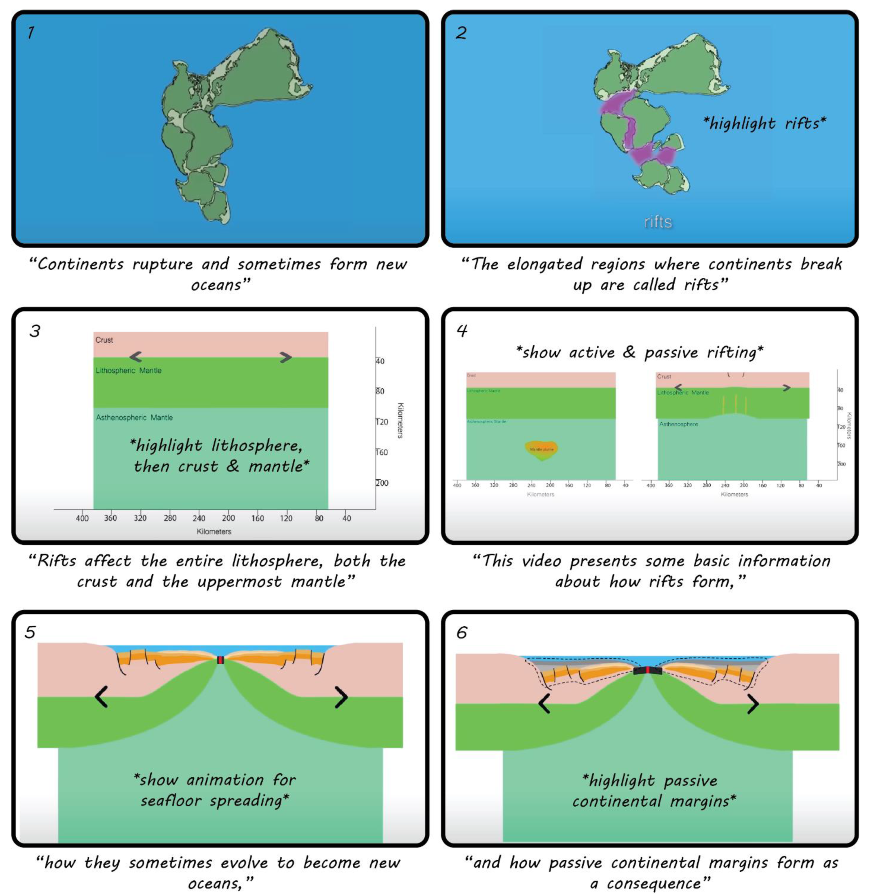
Figure 1 presents an example of a portion of the storyboard for the upper-division rifting Geovid. Storyboarding can be very simple sketches of what will be displayed on-screen during different parts of the narration, but it is useful to do more detailed sketches and planning for the animations.
Once a storyboard has been completed, the production team must decide what needs to be animated and what should be shown using static figures and video footage. Mixing these different types of visualizations keeps the viewer interested and reduces the amount of time-consuming animation production; video footage also allows the Geovid to better present aspects of geography and travel. Animations for the upper-division rifting video were done using Adobe Illustrator and Adobe After Effects. Adobe Illustrator was used for digitizing a basic cross-section of the Earth’s interior (continental crust, lithospheric mantle, and asthenosphere). Later, these digital sketches were brought into Adobe After Effects, where keyframe animation techniques were used to animate active rifting, passive rifting, sedimentation, formation of embryonic oceans, and seafloor spreading.
After the animation sequences are completed, the team begins stitching together the narration and animations, adding video footage where appropriate. To do this, we used Adobe Premiere Pro (a video editing software). Video footage for the upper-division Geovid came from YouTube, and the original creators are credited in the video. It is useful to incorporate real-life footage when possible because it helps diversify the final product, making the video more interesting to watch and gives the audience a real-life perspective. After compiling the narration, animations, and video footage all in one sequence, the file was rendered and exported and then finally posted on the UTD-GSS YouTube channel.
3. Educational Theory and Video Review/Validation
Cognitive load theory explores why certain kinds of materials can be difficult for students to learn. The key governing principle of this theory is that an individual’s working memory is limited in the number of elements it can manage simultaneously [
13]. In order to engage in higher-level cognitive processes, individuals must have built schemas (defined as a cognitive framework that helps organize and interpret information such as the language and process phenomena of geosciences) which allow connections to be made between multiple elements, which reduces cognitive load and facilitates learning [
13]. It is especially important to keep cognitive load considerations in mind when teaching geoscience to lower-division undergraduate students, as they have much less in the way of the geoscientific schema than upper-division students. If the cognitive load from instruction is too great, then the information conveyed cannot be meaningfully consumed by the targeted student audience.
Our strategy was initially to make and vet a rifting Geovid for upper-division geoscience students, following presentations by Stern (co-author) developed over 39 years teaching a graduate course in tectonics and using examples from the NSF MARGINS and GeoPRISMS initiatives; then adapt this video for lower-division students by thoughtfully reducing the cognitive load imposed on that audience. The upper-division Geovid, “Continental Rifts, New Oceans, and Passive Continental Margins: Plate Tectonics Basics 2”, is a little more than 10 min long and covers how continental rifting sometimes evolves to form new oceans and passive continental margins. The Geovid can be viewed on YouTube (see [
11]). Creating it took roughly 1.5 years (~700 h of work), and it has been well-received, with over 4900 views on YouTube as of March 2021.
We first assessed the scientific validity of the upper-division video through feedback from presentations at regional [
14] and national [
15] GSA (Geological Society of America) meetings, where we gathered responses from the audience and asked experts in continental rifting to provide their feedback. At a GeoPRISMS workshop in San Antonio in February 2019, we targeted experts on continental rifting, who were asked to watch the video and fill out a survey focused on both the scientific accuracy and on how engaging they found the video to be. The results of the survey showed that: (1) they liked the overall aesthetics, simplicity of the animations, and the real-world examples; (2) they wanted more imagery and thought the video moved too fast; and (3) they pointed out that we omitted many important details, such as asymmetry of rifts, the role of mantle plumes, and how the lithosphere/asthenosphere boundary was portrayed. This feedback gave us confidence in the video’s overall scientific content, though we knew that adding the additional detail suggested would increase its cognitive load, which was already high.
Based on our work with and feedback from the original Geovid, we set about simplifying it for a lower-division audience. Our strategy for doing this was to reduce its cognitive load. One way to evaluate cognitive load in a Geovid is through the number of call-outs. The upper-division video has 39 call-outs (~4 per min). To better address the cognitive load challenges the upper-division video places on a lower-division audience, the following steps were taken:
Survey introductory geoscience courses to assay student familiarity with terms and concepts used in the upper-division Geovid;
Review five current textbooks used in introductory geology courses taught at universities in the Dallas-Fort Worth area, where two of the authors were located;
Use this information to modify the upper-division Geovid for the lower-division audience;
Assess the new lower-division Geovid in an undergraduate classroom. This work was conducted at the University of South Florida.
We used the results of these surveys to revise the upper-division Geovid for lower-division students. The narrative for the new lower-division Geovid was edited to remove low-scoring call-out terms (discussed in more detail later) and reduce the call-outs overall. Twenty call-out terms out of the original 39 (decompression melting, plume, active rifts, passive rifts, subaerial, submarine, grabens, horsts, rift-flank highs, rift axis, terminal lakes, terrigenous sediments, asymmetric half grabens, rift-to-drift transition, deformation, igneous activity, mid-ocean ridge, active margins, transform faults, and convergent plate boundaries) were not used in the lower-division Geovid, which has a total of 24 call-out terms. Six new call-out terms (magmas, terrestrial sediments, limestone, shale, continental shelves, and coastal plains) were added because they better fit with textbook descriptions (e.g., replacing “terrigenous sediments” with “terrestrial sediment” as used in the introductory textbooks), and some were added to be more descriptive (e.g., calling out limestone and shale during the discussion of marine sediments), and some were added in order to give more detail (e.g., introducing continental shelves and coastal plains to the discussion of passive continental margins). The lower-division Geovid is significantly shorter, at 7:08, and can be viewed on YouTube (see [
16]). Interestingly, this version has more views (>5400 as of March 2022) than the upper-division version, which was posted 8 months earlier. Our final step is assessing the effectiveness of the lower-division continental rifting video in the classroom, an effort that began in the Spring of 2020, and is still underway.
4. Results
Here we present our results for (1) lower-division undergraduate student familiarity of call-out terms used in the upper-division Geovid; (2) assessment of how textbooks present the call-out terms; and (3) preliminary assessment of our lower-division Geovid in an introductory Earth science classroom.
4.1. Lower-Division Undergraduate Student Familiarity of Call-Out Terms Used in Upper-Division Geovid
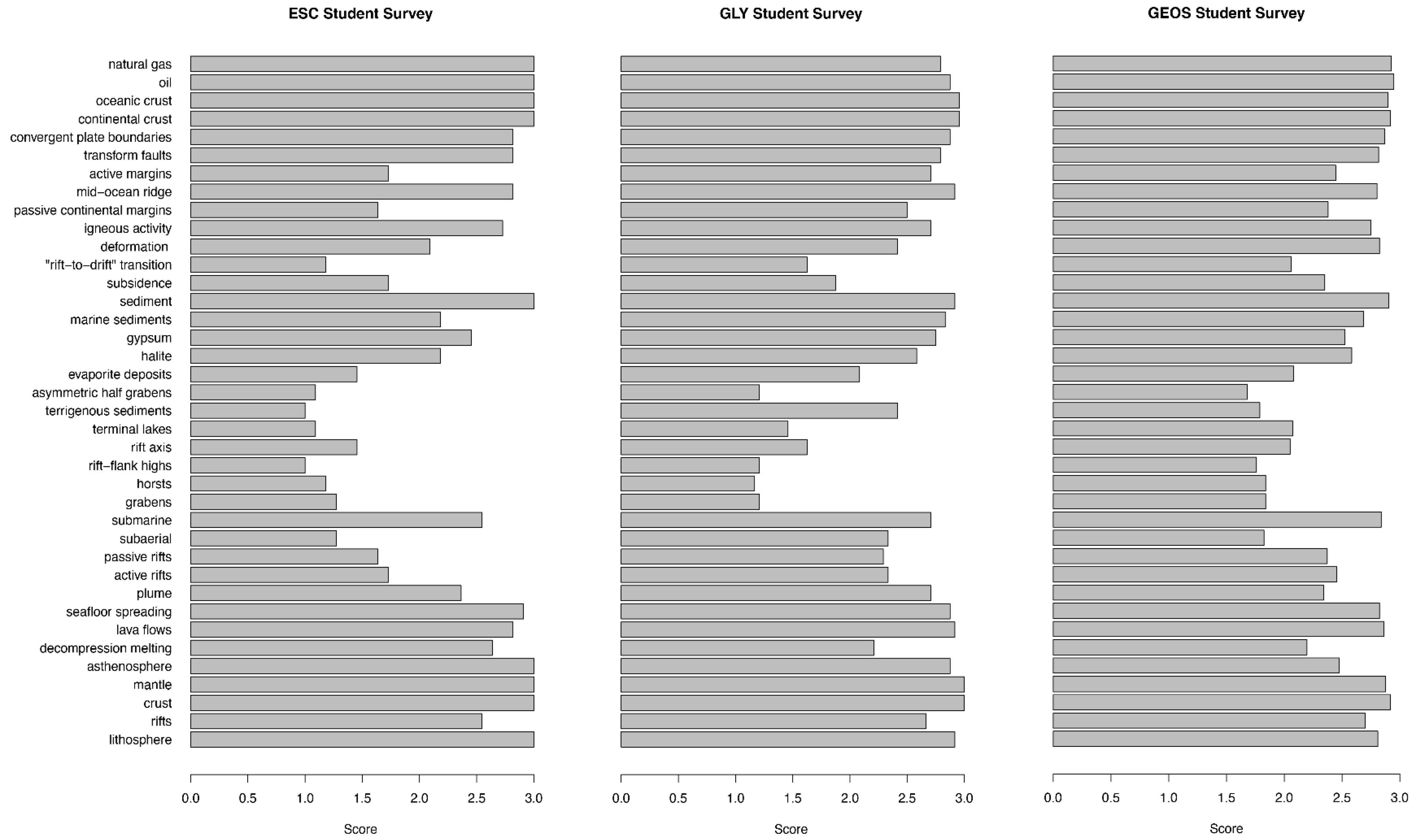
Students in three introductory geology and Earth science courses (
n = 173) were asked to participate in a survey to better understand the cognitive load imposed on lower-division undergraduate students by the upper division Geovid. They were given a list of 38. There were 39 call-out terms in the upper-division Geovid. There was an error in the student survey that repeated a term and did not include the thirty-ninth term. That is why we say 38 terms here. They were then asked to rate each term on a scale of 1–3 (1 = I have never heard this term; 2 = I have heard this term, but I’m not familiar with it; 3 = I am familiar with this term). Low scores on a term imply that the concept is more likely to impose a higher cognitive load on the student viewer than terms with a high score. The results of these surveys are summarized in
Figure 2. To the first order, the students in the three classes were similarly familiar or unfamiliar with different call-out terms. Overall, students were very familiar with some terms: “natural gas”, “oil”, “oceanic crust”, “continental crust”, ”convergent plate boundaries”, “transform faults”, “mid-ocean ridge”, “sediment”, “seafloor spreading”, “lava flows”, “asthenosphere”, “mantle”, “crust”, and “lithosphere”. Students were unfamiliar with the terms “horst” and “graben”, so it is unsurprising that they were also unfamiliar with the derivative term “asymmetric half grabens”. Most were unfamiliar with other technical terms used to describe rifting and its associated landforms and sedimentary features: “subsidence”, “rift-to-drift transition”, “rift flank high”, “terrigenous sediments”, “terminal lakes”, and “subaerial”.
4.2. Assessment of How Textbooks Present the Call-Out Terms
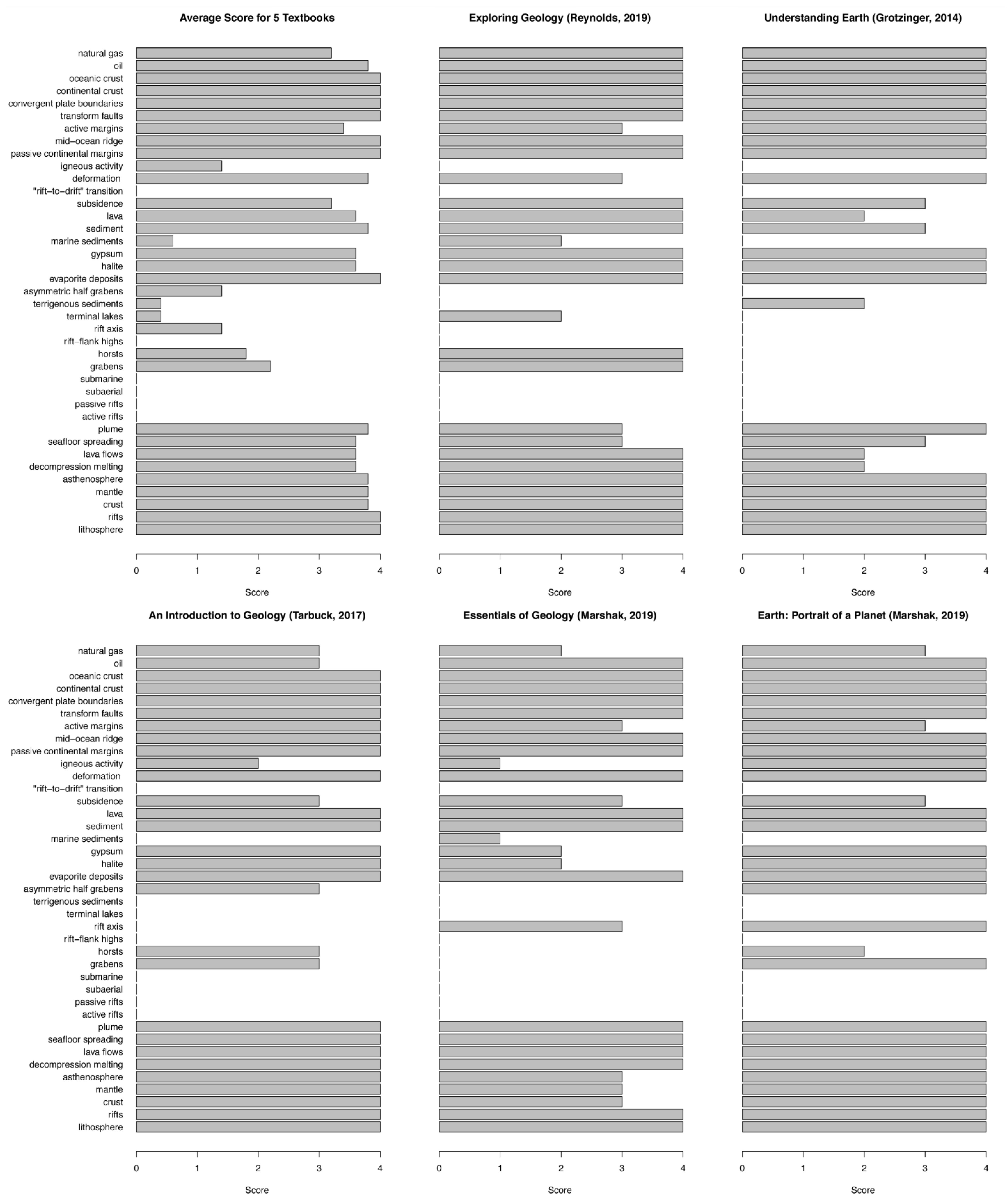
Five different textbooks, required for 2019 geology courses at different universities in the Dallas-Fort Worth area, were surveyed to better understand the extent to which call-out terms in the upper-division rifting Geovid were discussed. A Geovid call-out term that is also addressed in textbooks may be more familiar to students and thereby impose a lesser cognitive load than terms that are not mentioned in textbooks. The books examined included: (1) Reynolds et al. 2019 [
17]; (2) Marshak, Essentials of Geology 2019 [
18]; (3) Tarbuck and Lutgens 2017 [
19]; (4) Grotzinger and Jordan 2014 [
20]; and (5) Marshak, Earth: Portrait of a Planet 2019 [
21].
To track the extent to which each call-out term is discussed in each of the textbooks, a scoring system was created; +1 for mention of the term, +2 for a detailed description of the term, +1 for mention in a diagram, and +2 for a dedicated diagram. One term could receive a maximum of 4 points or a minimum of 0 points.
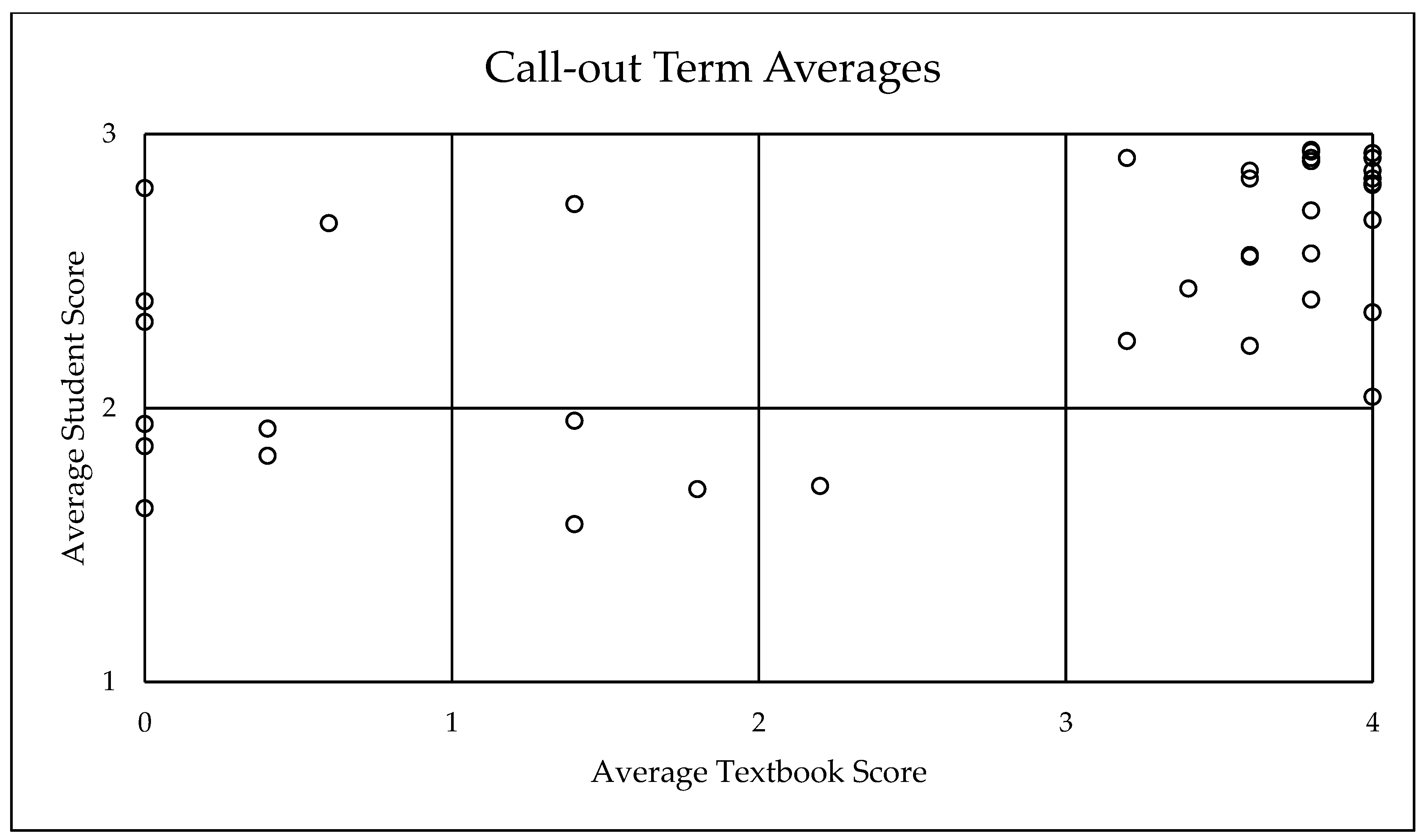
Figure 3 shows the results from the textbook survey. Additionally, there were several call-out terms that were not mentioned in any of the five textbooks. Texts mostly describe and do not describe call-out terms similarly. Twenty-three call-out terms were presented in some detail: “Natural gas”, “oil”, “oceanic crust”, “continental crust”, “convergent plate boundaries”, “transform faults”, “active margins”, “deformation”, “subsidence”, “lava”, “sediment”, “gypsum”, “halite”, “evaporite deposits”, “plume”, “seafloor spreading”, “lava flows”, “decompression melting”, “asthenosphere”, “mantle”, “crust”, “rifts”, and “lithosphere”. Fourteen call-out terms were consistently not or sporadically mentioned: “igneous activity”, “rift-to-drift transition”, “marine sediments”, “asymmetric half grabens”, “terrigenous sediment”, “terminal lakes”, “rift axis”, “rift-flank high”, “horsts”, “grabens”, “submarine”, “subaerial”, “passive rifts”, and “active rifts”. We wanted to check the relationship between student familiarity and textbook mention. From the student surveys and the textbook review, we found that terms that scored low in the textbook review generally also scored low in the student surveys. This is shown in
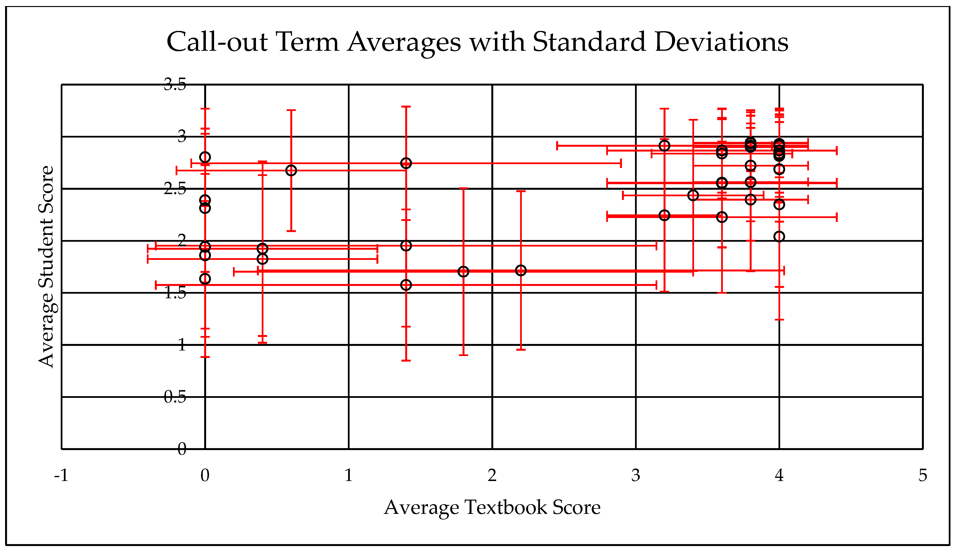
Figure 4. From these results, we inferred that student knowledge and textbook information were aligned and would thus serve as good benchmarks to guide the adaption of the lower-division Geovid. Additionally,
Figure 5 shows the relatively low standard deviations from textbook and student surveys. High-scoring terms on textbook and student surveys had lower standard deviations than low-scoring terms. Additionally, terms that scored as 0 on the textbook survey scored 0 across all five textbooks (no standard deviation). The same was true for terms that scored 4 on the textbook survey. This shows that there was some agreement between textbooks about the content. Overall the standard deviations stay relatively low, with an average deviation of 0.499 for textbook surveys and 0.579 for student surveys.
4.3. Preliminary Assessment of Lower-Division Geovid in an Introductory Earth Science Classroom
We introduced the lower-division Geovid on continental rifting for formative review in a section of ESC 2000 (Introduction to Earth Science: 80 students/section) at the University of South Florida in Tampa, FL in the Fall of 2019 and conducted a preliminary learning assessment on the Geovid in the same course in the Fall of 2020. The 2019 offering of ESC 2000 was in a live lecture format, while the 2020 course was taught in a synchronous online format as a result of access and distancing requirements related to the COVID-19 pandemic. Feedback from the 2019 course was limited as the video only became available late in the semester. Our primary changes in its presentation for the 2020 offering related to better integration into the online course: specifically, the Geovid was included as an assignment in support of course discussions of marine geology and seafloor spreading, as a primary means aside from the course’s textbook of describing how oceans form. Learning goals for the use of this Geovid were to familiarize students with the process of continental rifting in terms of the 3D structure of the phenomenon; to enable students to recognize geologic surface features related to continental rifting; to recognize the societal significance of rifted continental margins as the primary sites of human habitation and commerce.
Our learning assessment for the lower-division Geovid involved assigning the video as a course activity and having students respond to a short set of questions, one of which was prompt to sketch and annotate a profile of a rifting continental margin, following the Concept Sketch strategy of Johnson and Reynolds [
22]. Text-based questions asked students to identify a recently rifted marine basin in Google Earth and to consider the significance of the locations of several major cities (e.g., Shanghai and New York), all of which were located on passive continental margins. Assignment scoring was based on a multiply-rated rubric, in which an accurate sketch, correct annotation, and correct answers to text-based questions were each worth one point, with half-points for partly correct responses. A related post-assignment extra-credit question was included on the course’s final exam some six weeks later, asking students to provide an image from Google Earth of a recently rifted continental margin.
Numerical results from the course assignment are outlined in
Table 1. Students in generally encountered challenges in correctly sketching a profile view of a rifting margin, and annotation of the sketches were often incomplete. Part of this challenge clearly related to the necessity in an online course of generating digital versions of what would otherwise have been hand-drawn sketches: while many students simply did the requested sketches by hand and then turned in photographed JPEG or PDF versions of them (as was explicitly encouraged), others attempted to do digital sketches in Adobe Illustrator, MS Powerpoint, and other applications, with very limited success; and a few searched the web and provided clean sketch images they found, generally with documentation as to their online sources. The sketch annotations provided were generally better and clearer than the sketches themselves, and their responses to the text-based questions were largely correct. Student responses to the exam question were also largely correct, with 76% of those who answered the question earning partial or full credit for their chosen land features.
Our preliminary results, based on the full implementation of the lower-level Geovid in a single section of an online introductory Earth science offering, points to the development and persistence of some degree of conceptual understanding of continental rifting processes through the use of our lower-division Geovid on this topic. Whether any 3D understanding of how rifting occurs is developed is unclear and will likely require additional data collected in course sections where students perceive no limits on acceptable digital uploads for assignments. Ongoing work involves outreach to a subset of the participating students for short interviews to better understand any perceived limitations in responding to our assessment prompts and to gather further student impression and affective data on the Geovid and its classroom implementation.
5. Discussion
The difference in time and effort between making Geovids with animations or without them is large, especially for beginners [
23]. Animation-heavy Geovids require greater effort per unit time than simply filming and editing. Adobe After Effects (our chosen animation software) has a steep learning curve, though abundant YouTube and Adobe tutorials make it possible to self-teach. Once learned, subsequent animation efforts are significantly easier and less time-consuming. The first author and another undergraduate, both neophytes, took 8 months to create just the animations for the upper-division video and creating the entire Geovid took close to a year and a half (~700 h of work). The lower-division Geovid was finished in 3 months by one student (~200 h of work). Some animations from the upper-division Geovid were recycled for the lower-division Geovid, but other animation sequences had to be remade or significantly modified. Engaging computer literate students for these projects is a good strategy, but these students also need to have an interest in and a basic understanding of the Earth sciences. Many university students are motivated to gain research experiences and will be familiar with their personal activities with basic video editing. With the guidance of the primary investigator, students making the Geovid both gain a more intimate knowledge of the field they are studying, and they learn to apply this understanding creatively.
We found that when creating Geovids, it is important to have regular, weekly meetings to monitor progress on the project to maintain momentum. It is also critical that there be good communication between the science expert(s) and the animator/editor(s). The science expert(s) need to guide and critique the animator/editor(s) to ensure scientific accuracy is not lost in the production process. Educational experts, willing faculty, and willing student participants also need to be involved in order to pursue any kind of assessment of a Geovid’s classroom effectiveness. Making an effective and useful Geovid is thus a team effort.
The implications of this project go beyond the creation of a Geovid about continental rifting that is useful in introductory university classrooms. The ability to generate a video and edit it into useful educational content with commonly available software has been a central feature of the abrupt retooling of both K-12 and higher education in the COVID-19 pandemic, as has been the substantial time commitments involved in doing so. In the geosciences, we need to grow our video development capabilities, but at the same time, we need to survey which Earth systems are not well presented to students via textbooks, lectures, and static imagery and prioritize the creation of Geovidss to fill these curricular holes. Doing so should lead to students who will graduate with a much richer understanding of their discipline and the ability to make more informed decisions as scientists and citizens as they enter the workforce. Additionally, the methodologies used here for analyzing how different textbooks cover key topics, completed in this case for a specific Geovid project, also provide an objective way to compare textbook approaches and the quality and nature of their content coverage, which could be used to help inform professors as to the texts that might best suit the needs of their students.
6. Conclusions
As distance learning becomes increasingly important, Geovids provide powerful tools for geoscience instructors to help teach their students both inside and outside of a normal classroom setting and for students to learn on their own. Geovids which are well designed (research-based, vetted by experts, have cognitive loads that are appropriate for the target audience, have high video and audio quality, and are not too long) are an excellent way to help students understand complex processes such as continental rifting. While there is a substantial learning curve involved in creating Geovids, there are great rewards for the viewer, the creator, and the Earth Science community. The viewer benefits because they have been provided with an opportunity to better understand the process being explained. The challenged viewer can watch the Geovid at their leisure and rewatch as much as they need to, stopping it at points for careful study. The creator benefits because the process of creation requires rethinking the process and how to best explain it and because the same Geovid can be shown to many different classes. The community benefits because once a good Geovid is created and posted on YouTube, anyone can watch and use it in their classroom. Our videos are in English, but some are translated into other languages (Spanish, see [
24]). At UT Dallas, the second author engages students to help make the videos, and these students gain a deeper understanding of the process as well. These students also gain the valuable job skill of being able to make a short video about a scientific process. Building a catalog of videos/animations curated by the scientists that know the subject intimately and building a culture that knows how to make high-quality Geovids will be invaluable to future generations of students.
Author Contributions
Methodology, R.J.S. and J.R.; Investigation, S.W., J.R. and C.B.; data curation, S.W., J.R. and C.B.; writing—Original draft preparation, S.W.; writing—Review and editing, S.W., R.J.S. and J.R.; supervision, R.J.S. and J.R.; funding acquisition, R.J.S. and J.R. All authors have read and agreed to the published version of the manuscript.
Funding
This research was funded by the National Science Foundation, grant NSF-DUE1712495 to R.S. and grant NSF DUE-1712206 to J.R.
Institutional Review Board Statement
Data collection from students at the University of South Florida was conducted following USF Institutional Review Board (IRB) Protocol 00029494 (ap-proved 2/26/17).
Informed Consent Statement
Student participants provided informed consent, per the USF IRB protocol above.
Acknowledgments
This is UTD Geosciences contribution #1532. Thanks to Lochlan Vaughn for helping create the upper-division rifting video.
Conflicts of Interest
The authors declare no conflict of interest.
References
- Lowe, R.; Ploetzner, R. (Eds.) Learning from Dynamic Visualization; Springer International Publishing: Cham, Switzerland, 2017; p. 386. [Google Scholar] [CrossRef]
- Stern, R.J.; Lieu, W.; Mantey, A.; Ward, A.; Fechter, T.; Farrar, E.; McComber, S.; Windler, J. A new animation of subduction zone processes developed for the undergraduate and community college audience. Geosphere 2017, 13, 628–643. [Google Scholar] [CrossRef] [Green Version]
- Yang, E.; Andre, T.; Greenbowe, T.; Tibell, L. Spatial ability and the impact of visualization/animation on learning electrochemistry. Int. J. Sci. Educ. 2003, 25, 329–349. [Google Scholar] [CrossRef]
- Edelson, D.C.; Gordin, D.N.; Pea, R.D. Addressing the challenges of inquiry-based learning through technology and curriculum design. J. Learn. Sci. 1999, 8, 391–450. [Google Scholar]
- Gordin, D.N.; Pea, R.D. Prospects for scientific visualization as an educational technology. J. Learn. Sci. 1995, 4, 249–279. [Google Scholar] [CrossRef]
- Libarkin, J.C.; Brick, C. Research Methodologies in Science Education: Visualization and the Geosciences. J. Geosci. Educ. 2002, 50, 449–455. [Google Scholar] [CrossRef]
- Bobek, E.; Tversky, B. Creating Visual Explanations Improves Learning. Cogn. Res. Princ. Implic. 2016, 1, 1–14. [Google Scholar] [CrossRef] [PubMed] [Green Version]
- Munzner, T.; Johnson, C.; Moorhead, R.; Pfister, H.; Rheingans, P.; Yoo, T.S. 2 NIH-NHS visualization research challenges report summary. IEEE Comput. Graph. Appl. 2006, 26, 20–24. [Google Scholar] [CrossRef] [PubMed]
- Lowe, R.; Bouchet, J.-M. A compositional approach to design of educational animations. In Learning from Dynamic Visualization; Lowe, R., Ploetzner, R., Eds.; Springer International Publishing: Cham, Switzerland, 2017; pp. 5–30. [Google Scholar]
- McGill, G.G. Designing instructional science visualizations in the trenches: Where research meets production reality. In Learning from Dynamic Visualization; Lowe, R., Ploetzner, R., Eds.; Springer International Publishing: Cham, Switzerland, 2017; pp. 119–153. [Google Scholar]
- UTD Geoscience Studio. Continental Rifts, New Oceans, and Passive Continental Margins: Plate Tectonics Basics 2. YouTube Video, Posted by Siloa Willis, 4 February 2019. Available online: https://youtu.be/W6oJKsSiLEI (accessed on 20 December 2020).
- Pashler, H.; McDaniel, M.; Rohrer, D.; Bjork, R. Learning styles: Concepts and evidence. Psycho. Sci. Public Intereest 2008, 9, 105–119. [Google Scholar] [CrossRef] [PubMed] [Green Version]
- Sweller, J.; Chandler, P. Why Some Material Is Difficult to Learn. Cogn. Instr. 1994, 12, 185–233. [Google Scholar] [CrossRef]
- Willis, S.; Stern, R.J.; Vaughn, L.; Ryan, J.; Ricchezza, V. A New Animation of Continental Rifting and Formation of New Oceans and Continental Margins for Undergraduates. In Proceedings of the GSA Annual Meeting (Indianapolis), Indianopolis, IN, USA, 4–7 November 2018. [Google Scholar]
- Willis, S.; Stern, R.J.; Ryan, J.; Ricchezza, V. Assaying Lower Division Undergrads’ Knowledge about Continental Rifting to Tailor Geoscientific video/animations for Introductory Classroom Use. In Proceedings of the GSA Annual Meeting (Phoenix), Phoenix, AZ, USA, 22–25 September 2019. [Google Scholar]
- UTD Geoscience Studio. Continental Rifting, New Oceans, and Passive Continental Margins for Beginners. YouTube Video, posted by Siloa Willis, 16 October 2019. Available online: https://youtu.be/HQqrfIVkctM (accessed on 20 December 2020).
- Reynolds, S.J.; Johnson, J.K.; Morin, P.J.; Carter, C.M. Exploring Geology, 5th ed.; McGraw-Hill Education: New York, NY, USA, 2019. [Google Scholar]
- Marshak, S. Essentials of Geology, 6th ed.; W.W. Norton & Company: New York, NY, USA, 2019. [Google Scholar]
- Tarbuck, E.J.; Lutgens, F.K. Earth: An Introduction to Physical Geology, 12th ed.; Pearson Education: Upper Saddle River, NJ, USA, 2017. [Google Scholar]
- Grotzinger, J.; Jordan, T.H. Understanding Earth, 7th ed.; W.H. Freeman and Company: New York, NY, USA, 2014. [Google Scholar]
- Marshak, S. Earth: Portrait of a Planet, 6th ed; W.W. Norton & Company: New York, NY, USA, 2019. [Google Scholar]
- Johnson, J.; Reynolds, S. Concept sketches—Using student and instructor generated annotated sketches for learning, teaching, and assessment in geology courses. J. Geosci. Educ. 2005, 53, 85–95. [Google Scholar] [CrossRef]
- Stern, R.J.; Ryan, J.F.; Wang, N.; Richezza, V.; Willis, S. Geoscience Videos and Animations, How to Make Them with your Students, and How to Use Them in The Classroom. Sch. Geosci. Fac. Staff Publ. 2020. [Google Scholar] [CrossRef]
- UTD GeoScience Studio en Español. 2020. YouTube Channel. Available online: https://www.youtube.com/channel/UCvIwg5aaGqOcPnqYa2NBs8Q (accessed on 20 December 2020).
| Publisher’s Note: MDPI stays neutral with regard to jurisdictional claims in published maps and institutional affiliations. |
© 2021 by the authors. Licensee MDPI, Basel, Switzerland. This article is an open access article distributed under the terms and conditions of the Creative Commons Attribution (CC BY) license (http://creativecommons.org/licenses/by/4.0/).


