
Enhancing Ecosystem Services to Minimize Impact of Climate Variability in a Dry Tropical Forest with Vertisols

 ,
,
Abstract
:1. Introduction
2. Materials and Methods
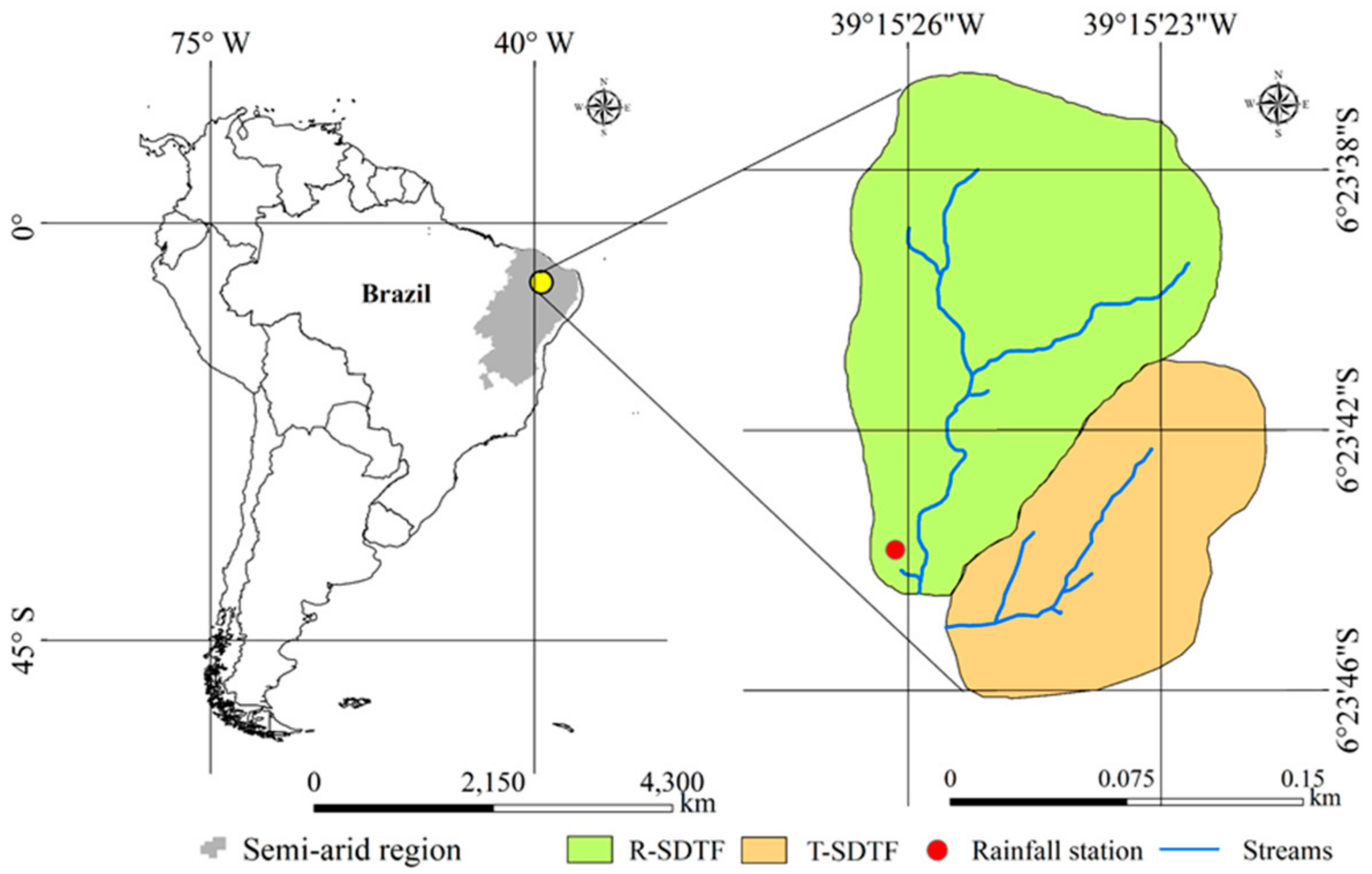
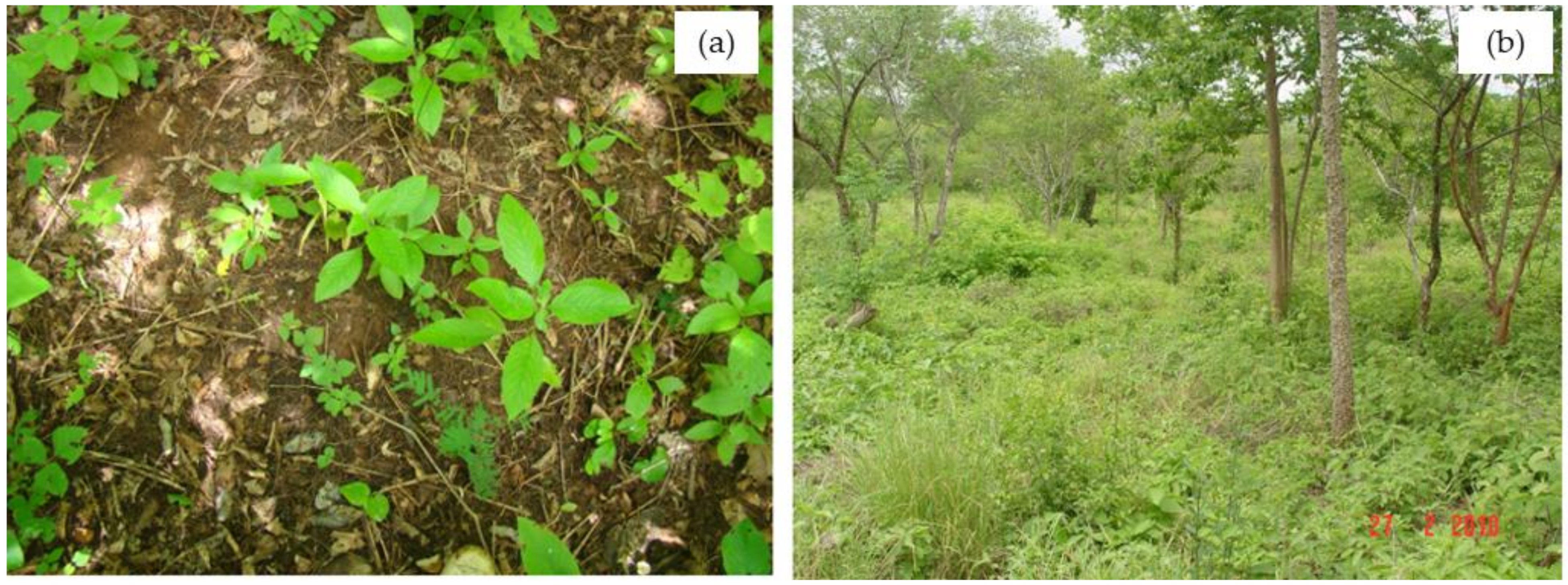
2.1. Study Area
2.2. Data Analysis
2.2.1. Long-Term Rainfall Series
2.2.2. Short-Term Rainfall Runoff Events
2.2.3. Statistics
3. Results and Discussion
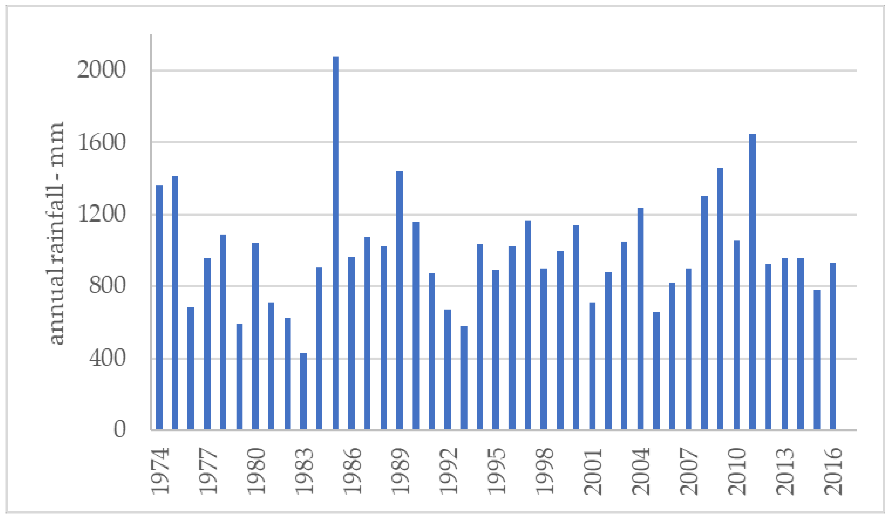
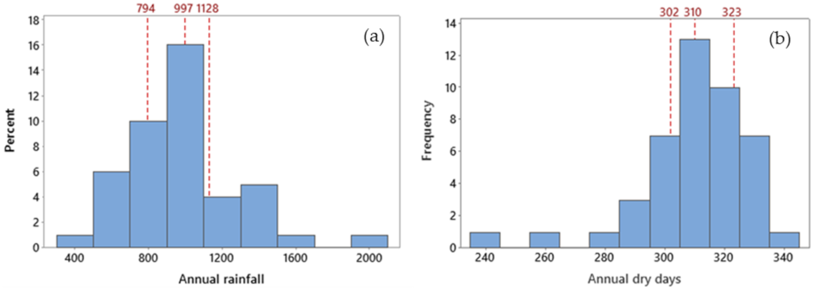
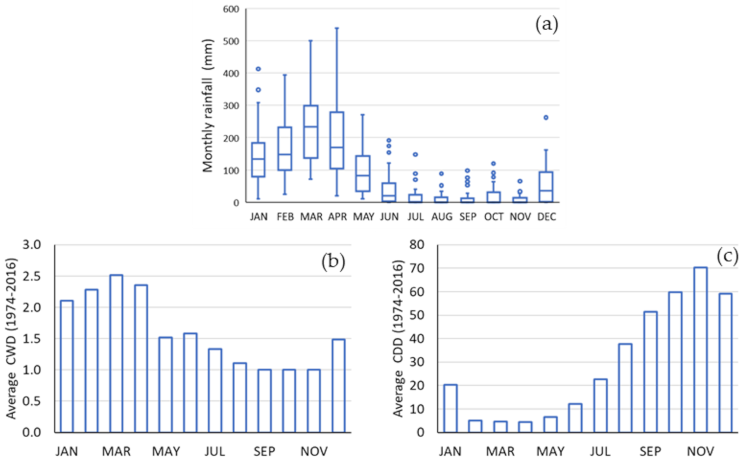
3.1. Long-Term Rainfall Series
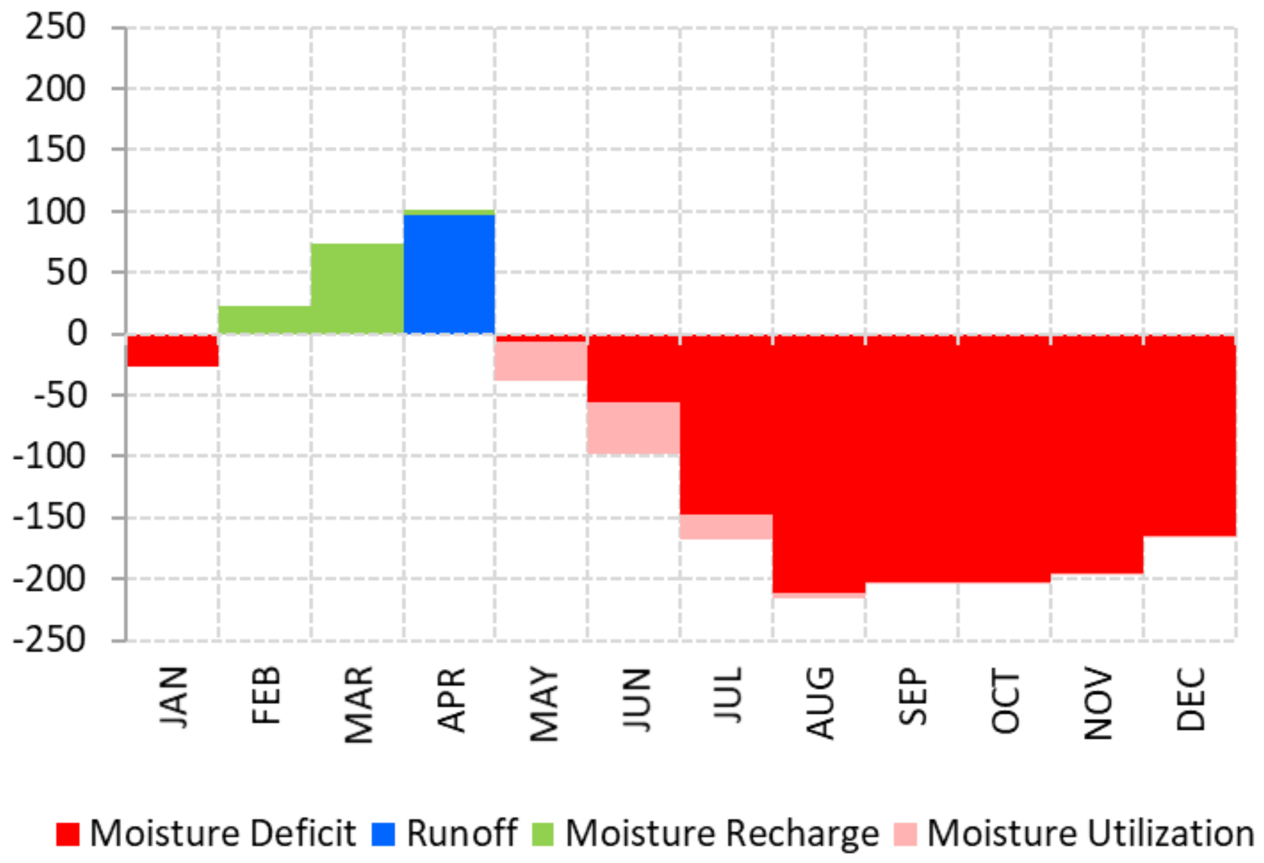
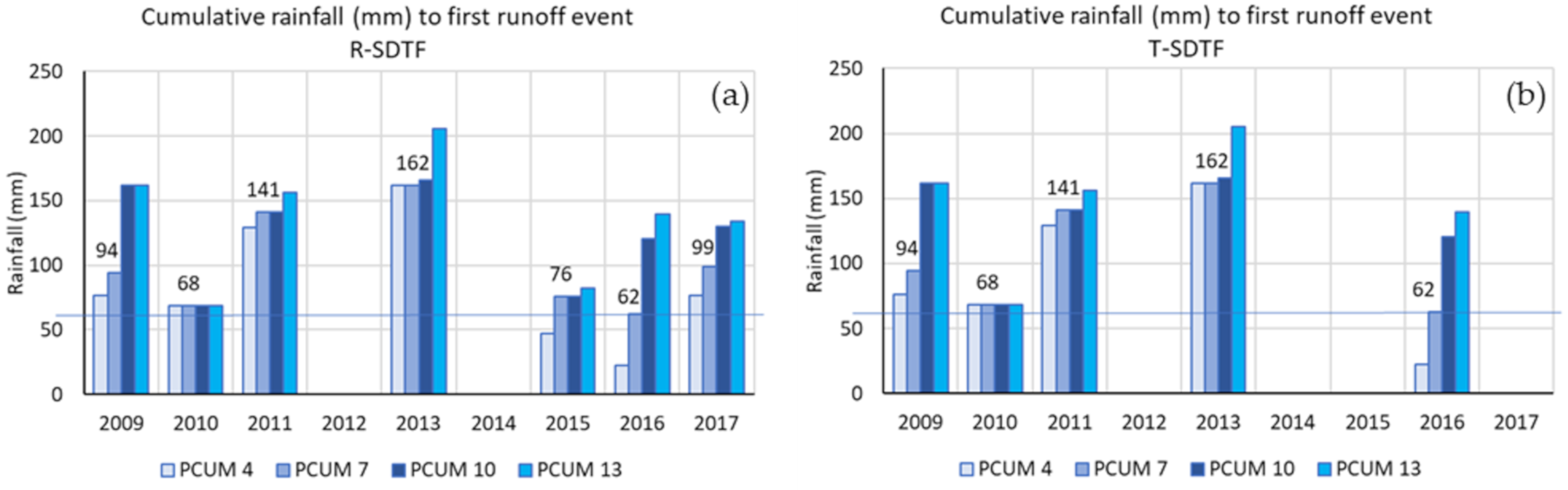
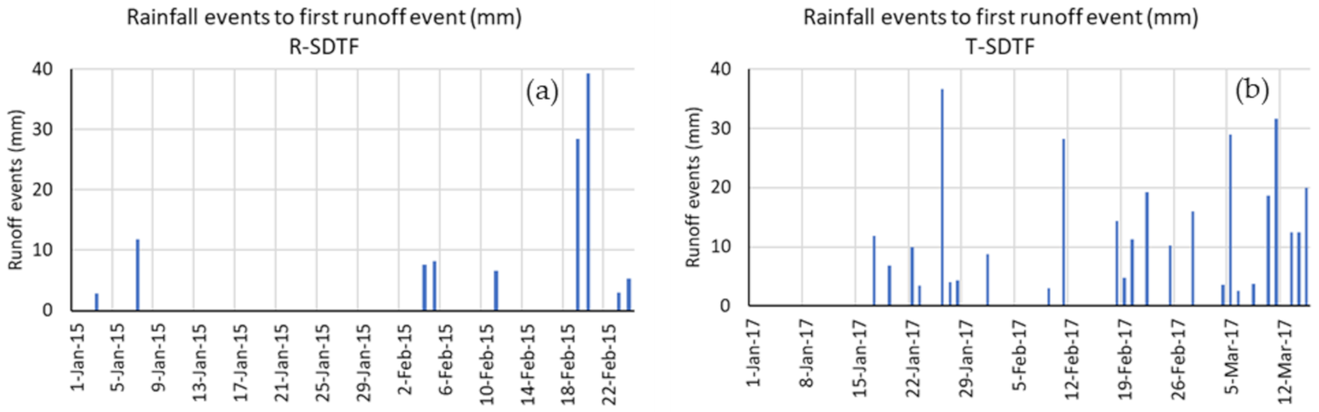
3.2. Short Term Rainfall-Runoff Events
4. Conclusions
Author Contributions
Funding
Informed Consent Statement
Data Availability Statement
Acknowledgments
Conflicts of Interest
References
- UN. 2010–2020: UN Decade for Deserts and the Fight Against Desertification. [WWW Document]. 2019. Available online: https://www.un.org/en/events/desertification_decade/whynow.shtml (accessed on 13 May 2020).
- Huang, J.; Ji, M.; Xie, Y. Global semi-arid climate change over last 60 years. Clim. Dyn. 2016, 46, 1131–1150. [Google Scholar] [CrossRef] [Green Version]
- Huang, J.; Li, Y.; Fu, C.; Chen, F.; Fu, Q.; Dai, A.; Shinoda, M.; Ma, Z.; Guo, W.; Li, Z.; et al. Dryland climate change: Recent progress and challenge. Rev. Geophys. 2017, 719–778. [Google Scholar] [CrossRef]
- Marengo, J.A.; Torres, R.R.; Alves, L.M. Drought in Northeast Brazil—Past, present, and future. Theor. Appl. Clim. 2016, 129, 1189–1200. [Google Scholar] [CrossRef]
- Kihupi, N.I.; Tarimo, A.K.P.R.; Masika, R.J.; Boman, B.; Dick, W.A. Trend of Growing Season Characteristics of Semi-Arid Arusha District in Tanzania. J. Agric. Sci. 2015, 7, 45–55. [Google Scholar] [CrossRef]
- Gebru, T.A.; Brhane, G.K.; Gebremedhin, Y.G. Contributions of water harvesting technologies intervention in arid and semi-arid regions of Ethiopia, in ensuring households’ food security, Tigray in focus. J. Arid Environ. 2021, 185, 104373. [Google Scholar] [CrossRef]
- Lal, R. Sequestering carbon and increasing productivity by conservation agriculture. J. Soil Water Conserv. 2015, 70, 55–62. [Google Scholar] [CrossRef] [Green Version]
- Andrade, E.M.; Guerreiro, M.J.S.; Palácio, H.A.Q.; Campos, D.A. Ecohydrology in a Brazilian tropical dry forest: Thinned vegetation impact on hydrological functions and ecosystem services. J. Hydrol. Reg. Stud. 2020, 27, 100649. [Google Scholar] [CrossRef]
- Allen, K.; Dupuy, J.M.; Gei, M.G.; Hulshof, C.; Medvigy, D.; Pizano, C.; Salgado-Negret, B.; Smith, C.M.; Trierweiler, A.; Bloem, S.J.; et al. Will seasonally dry tropical forests be sensitive or resistant to future changes in rainfall regimes? Environ. Res. Lett. 2017, 12, 1–16. [Google Scholar] [CrossRef] [Green Version]
- FAO. Global Ecological Zoning for the Global Forest Resources Assessment 2000—Final Report. Rome. [WWW Document]. 2001. Available online: http://www.fao.org/3/ad652e/ad652e00.htm (accessed on 13 May 2020).
- Miles, L.; Newton, A.C.; DeFries, R.S.; Ravilious, C.; May, I.; Blyth, S.; Kapos, V.; Gordon, J.E. A global overview of the conservation status of tropical dry forests. J. Biogeogr. 2006, 33, 491–505. [Google Scholar] [CrossRef]
- Alenius, T.; Mökkönen, T.; Holmqvist, E.; Ojala, A. Neolithic land use in the northern Boreal zone: High-resolution multiproxy analyses from Lake Huhdasjärvi, south-eastern Finland. Veg. Hist. Archaeobotany 2017, 26, 469–486. [Google Scholar] [CrossRef] [Green Version]
- Stuhler, J.; Orrock, J. Historical land use and present-day canopy thinning differentially affect the distribution and abundance of invasive and native ant species. Biol. Invasions 2016, 18, 813–1825. [Google Scholar] [CrossRef]
- Blackie, R.; Baldauf, C.; Gautier, D.; Gumbo, D.; Kassa, H.; Parthasarathy, N.; Paumgarten, F.; Sola, P.; Pulla, S.; Waeber, P.; et al. Tropical Dry Forests the State of Global Knowledge and Recommendations for Future Research; Cifor: Bogor, Indonesia, 2014; Volume 2. [Google Scholar]
- Pathak, P.; Sudi, R.; Wani, S.P.; Sahrawat, K.L. Hydrological behavior of Alfisols and Vertisols in the semi-arid zone: Implications for soil and water management. Agric. Water Manag. 2013, 118, 12–21. [Google Scholar] [CrossRef] [Green Version]
- Driessen, P.; Deckers, J.; Spaargaren, O.; Nachtergaele, F. Lecture Notes on the Major Soils of the World; Food and Agriculture Organization (FAO): Rome, Italy, 2000. [Google Scholar]
- Latham and Peter Ahn. Management of Vertisols under Semi-Arid Conditions, IBSRAM PROCEEDINGS No. 6. 1986. Available online: https://horizon.documentation.ird.fr/exl-doc/pleins_textes/divers15-08/010065123.pdf (accessed on 13 May 2020).
- Zuo, D.; Xu, Z.; Yao, W.; Jin, S.; Xiao, P.; Ran, D. Assessing the effects of changes in land use and climate on runoff and sediment yields from a watershed in the Loess Plateau of China. Sci. Total Environ. 2016, 544, 238–250. [Google Scholar] [CrossRef]
- Yair, A. Contrasting hydrological regimes in two adjoining semi-arid areas, with low rain intensities. J. Arid Environ. 2021, 187, 104404. [Google Scholar] [CrossRef]
- Kurtzman, D.; Baram, S.; Dahan, O. Soil-aquifer phenomena affecting groundwater under vertisols: A review. Hydrol. Earth Syst. Sci. 2016, 20, 1–12. [Google Scholar] [CrossRef] [Green Version]
- Debele, T.; Deressa, H. Integrated Management of Vertisols for Crop Production in Ethiopia: A Integrated Management of Vertisols for Crop Production in Ethiopia: A Review. J. Biol. Agric. Healthc. 2016, 6, 26–36. [Google Scholar]
- Ponette-González, A.; Marín-Spiotta, E.; Brauman, K.; Farley, K.; KC, K.W.; Young, K. Hydrologic Connectivity in the High-Elevation Tropics: Heterogeneous Responses to Land Change. Bioscience 2013, 64, 92–104. [Google Scholar] [CrossRef] [Green Version]
- Wu, Y.; Zhang, X.; Li, C.; Xu, Y.; Hao, F.; Yin, G. Ecosystem service trade-offs and synergies under influence of climate and land cover change in an afforested semiarid basin, China. Ecol. Eng. 2021, 159, 106083. [Google Scholar] [CrossRef]
- Lal, R. Saving global land resources by enhancing eco-efficiency of agroecosystems. J. Soil Water Conserv. 2018, 73, 100A–106A. [Google Scholar] [CrossRef] [Green Version]
- Lal, R. Soil carbon sequestration to mitigate climate change. Geoderma 2004, 123, 1–22. [Google Scholar] [CrossRef]
- Holdridge, L.R. Life Zone Ecology. For. Sci. 1968, 14, 382. [Google Scholar] [CrossRef]
- FAO. Global Ecological Zones for Fao Forest Reporting: 2010 Update. Rome. 2012. Available online: http://www.fao.org/3/ap861e/ap861e00.pdf (accessed on 13 May 2020).
- Guerreiro, M.J.S.; Andrade, E.M.; Abreu, I.; Lajinha, T. Long-term variation of precipitation indices in Ceará State, Northeast Brazil. Int. J. Climatol. 2013, 33, 2929–2939. [Google Scholar] [CrossRef]
- Moron, V.; Ward, M.; Navarra, A. Observed and SST-Forced seasonal Rainfall Variability Across Tropical America. Int. J. Climatol. 2001. [Google Scholar] [CrossRef]
- Dinka, T.M.; Morgan, C.L.S.; Mcinnes, K.J.; Kishné, A.S.; Harmel, R.D. Shrink-swell behavior of soil across a Vertisol catena. J. Hydrol. 2013, 476, 352–359. [Google Scholar] [CrossRef]
- Li, J.H.; Li, L.; Chen, R.; Li, D.Q. Cracking and vertical preferential fl ow through land fi ll clay liners. Eng. Geol. 2016, 206, 33–41. [Google Scholar] [CrossRef]
- Santos, J.C.N.; Andrade, E.M.; Guerreiro, M.J.S.; Medeiros, P.H.A.; Queiroz Palácio, H.A.; Araújo Neto, J.R. Effect of dry spells and soil cracking on runoff generation in a semiarid micro watershed under land use change. J. Hydrol. 2016, 541. [Google Scholar] [CrossRef]
- Krisnanto, S.; Rahardjo, H.; Fredlund, D.G.; Leong, E.C. Water content of soil matrix during lateral water flow through cracked soil. Eng. Geol. 2016, 210, 168–179. [Google Scholar] [CrossRef]
- Greve, A.; Andersen, M.; Acworth, R. Investigations of soil cracking and preferential flow in a weighing lysimeter filled with cracking clay soil. J. Hydrol. 2010, 393, 105–113. [Google Scholar] [CrossRef]
- Ma, J.; Kang, F.; Cheng, X.; Han, H. Moderate thinning increases soil organic carbon in Larix principis-rupprechtii (Pinaceae) plantations. Geoderma 2018, 329, 118–128. [Google Scholar] [CrossRef]
- Hata, K.; Kawakami, K.; Kachi, N. Higher Soil Water Availability after Removal of a Dominant, Nonnative Tree (Casuarina equisetifolia Forst.) from a Subtropical Forest. Pac. Sci. 2015, 69, 445–460. [Google Scholar] [CrossRef]
- Greve, A.; Acworth, R.; Kelly, B. Detection of subsurface soil cracks by vertical anisotropy profiles of apparent electrical resistivity. Geophysics 2010, 75, 85–93. [Google Scholar] [CrossRef]
- Asaye, Z.; Zewdie, S. Fine root dynamics and soil carbon accretion under thinned and un-thinned Cupressus lusitanica stands in, Southern Ethiopia. Plant Soil 2013, 366, 261–271. [Google Scholar] [CrossRef]
- Regan, C.M.; Connor, J.D.; Segaran, R.R.; Meyer, W.S.; Bryan, B.A.; Ostendorf, B. Climate change and the economics of biomass energy feedstocks in semi-arid agricultural landscapes: A spatially explicit real options analysis. J. Environ. Manag. 2017, 192, 171–183. [Google Scholar] [CrossRef] [PubMed]


| Properties | R-SDTF | T-SDTF | |
|---|---|---|---|
| Saturated hydraulic conductivity | m hr−1 | 0.25 | 0.20 |
| Phosphorus | g dm−3 | 11.63 | 45.79 |
| Organic matter | % | 0.88 | 1.48 |
| Sand | % | 18.4 | 12.4 |
| Silt | % | 33.75 | 38.15 |
| Clay | % | 47.85 | 49.43 |
| Soil texture | Clay | Clay | |
| Canopy cover | % | 90 | 60 |
| Ground cover | % | 30 | 100 |
| Daily Rainfall (mm) | Number of Wet Days | |||
|---|---|---|---|---|
| Annual | Jan–May | |||
| N (number) | 16014 | 2418 | 2109 | |
| Mean | 2.7 | 18.1 | 18.4 | |
| Std. Deviation | 10.0 | 19.7 | 19.7 | |
| Minimum | 0.00 | 0.20 | 0.20 | |
| Maximum | 174.0 | 174.0 | 174.0 | |
| Percentiles | 25th | 0.0 | 5.0 | 5.0 |
| 50th | 0.0 | 11.0 | 11.0 | |
| 75th | 0.0 | 24.0 | 25.0 | |
| Daily Rainfall Event (mm) | Runoff | ||||
|---|---|---|---|---|---|
| All Events | Runoff Generating | No Runoff Generating | |||
| N (number) | 257 | 67 | 190 | 67 | |
| Mean | 20.4 | 34.9 | 15.3 | 5.4 | |
| Std. Deviation | 19.3 | 23.7 | 14.4 | 7.2 | |
| Minimum | 1.3 | 5.3 | 1.3 | 0.01 | |
| Maximum | 162.0 | 162.0 | 80.3 | 34.5 | |
| Percentiles | 25th | 7.2 | 19.8 | 6.1 | 0.6 |
| 50th | 14.3 | 30.3 | 11.4 | 2.6 | |
| 75th | 27.9 | 47.9 | 18.2 | 7.0 | |
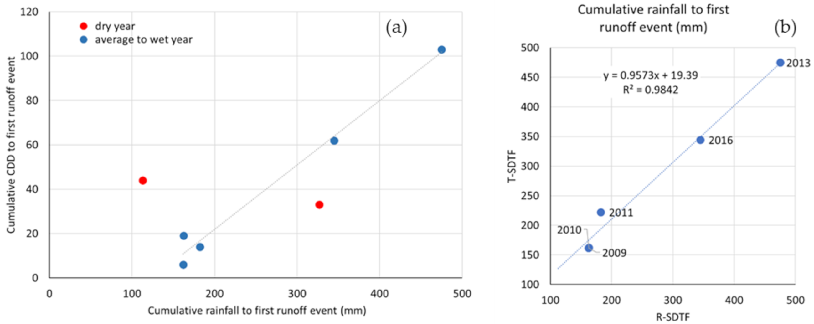
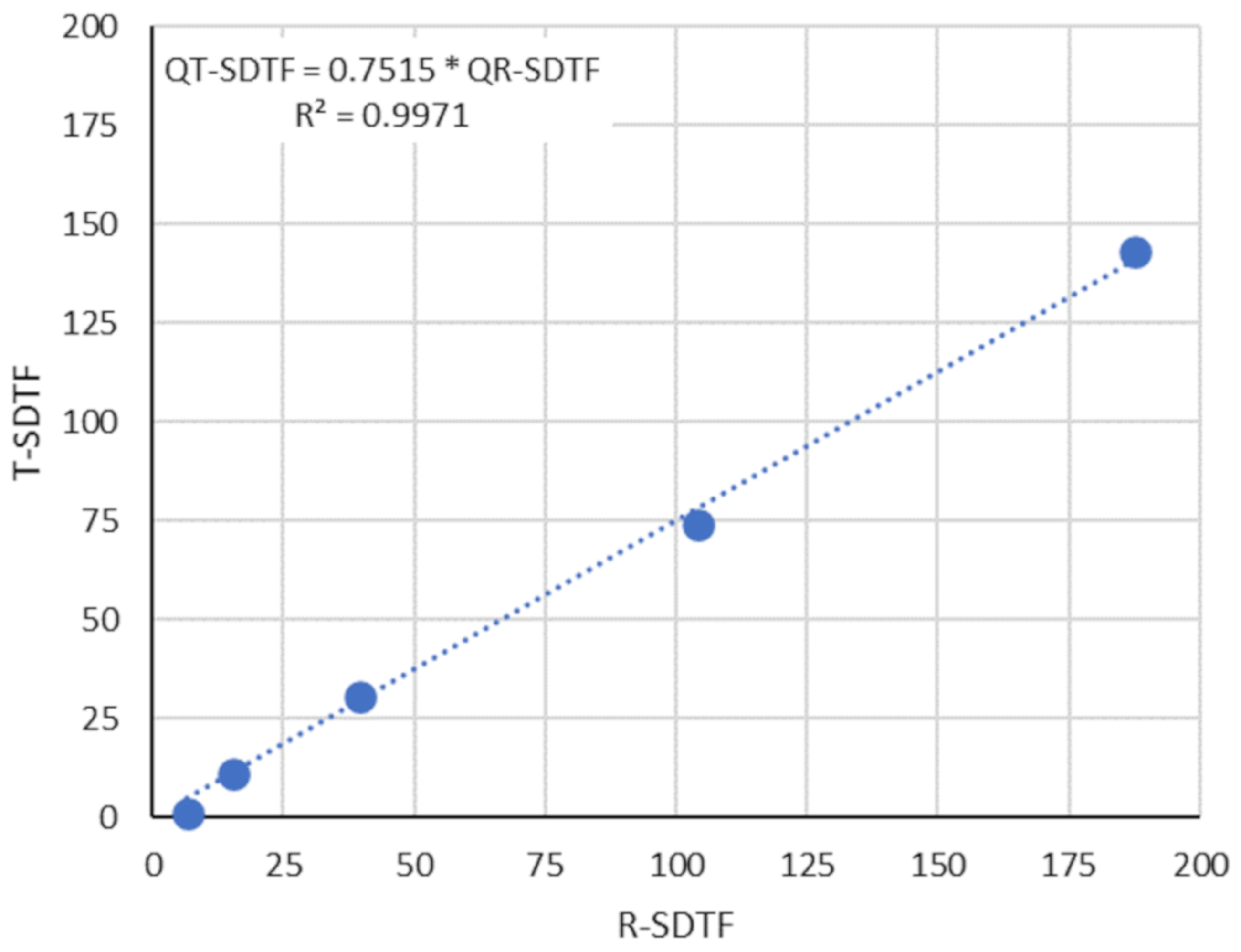
| Pcum (mm) | # Pevents | Pcum to Q1 (mm) | ΔT (days) | Qtotal (mm) | # Qevents | Pmin to Q (mm) | Pmax to no Q (mm) | ||||||
|---|---|---|---|---|---|---|---|---|---|---|---|---|---|
| Year | Wet Season | R | T | R | T | R | T | R | T | R | T | ||
| 2009 | 981.0 | 39 | 162.0 | 162.0 | 8 | 8 | 104.0 | 74.0 | 25 | 26 | 8.6 | 9.0 | 68 |
| 2010 | 711.0 | 26 | 163.0 | 163.0 | 23 | 23 | 15.0 | 11.0 | 7 | 9 | 28.7 | 10.0 | 80 |
| 2011 | 1308.0 | 54 | 182.0 | 222.0 | 21 | 25 | 188.0 | 143.0 | 26 | 22 | 12.0 | 12.0 | 69 |
| 2012 | SENSOR FAILURE | ||||||||||||
| 2013 | 634.0 | 28 | 475.0 | 475.0 | 126 | 126 | 39.0 | 30.0 | 2 | 2 | 44.0 | 44.0 | 59 |
| 2014 | SENSOR FAILURE | ||||||||||||
| 2015 | 507.0 | 32 | 113.0 | 0.0 | 52 | 0.1 | 0.0 | 1 | 0 | 5.3 | 56 | ||
| 2016 | 608.0 | 34 | 345.0 | 345.0 | 80 | 80 | 7.0 | 1.0 | 2 | 1 | 8.0 | 12.0 | 66 |
| 2017 | 583.0 | 46 | 327.0 | 0.0 | 49 | 8.0 | 0.0 | 4 | 0 | 2.0 | 40 | ||
Publisher’s Note: MDPI stays neutral with regard to jurisdictional claims in published maps and institutional affiliations. |
© 2021 by the authors. Licensee MDPI, Basel, Switzerland. This article is an open access article distributed under the terms and conditions of the Creative Commons Attribution (CC BY) license (http://creativecommons.org/licenses/by/4.0/).
Share and Cite
Guerreiro, M.S.; Maia de Andrade, E.; Palácio, H.A.d.Q.; Brasil, J.B.; Ribeiro Filho, J.C. Enhancing Ecosystem Services to Minimize Impact of Climate Variability in a Dry Tropical Forest with Vertisols. Hydrology 2021, 8, 46. https://0-doi-org.brum.beds.ac.uk/10.3390/hydrology8010046
Guerreiro MS, Maia de Andrade E, Palácio HAdQ, Brasil JB, Ribeiro Filho JC. Enhancing Ecosystem Services to Minimize Impact of Climate Variability in a Dry Tropical Forest with Vertisols. Hydrology. 2021; 8(1):46. https://0-doi-org.brum.beds.ac.uk/10.3390/hydrology8010046
Chicago/Turabian StyleGuerreiro, Maria Simas, Eunice Maia de Andrade, Helba Araújo de Queiroz Palácio, José Bandeira Brasil, and Jacques Carvalho Ribeiro Filho. 2021. "Enhancing Ecosystem Services to Minimize Impact of Climate Variability in a Dry Tropical Forest with Vertisols" Hydrology 8, no. 1: 46. https://0-doi-org.brum.beds.ac.uk/10.3390/hydrology8010046