
Application of Multi-Criteria Decision-Making Analysis to Rural Spatial Sustainability Evaluation: A Systematic Review


Abstract
:1. Introduction
1.1. Background Overview
1.2. Multi-Criteria Decision-Making
1.3. Literature Review
1.4. Research Purpose
- (1)
- Provide an up-to-date overview of the application of the MCDA method to the issue of rural spatial sustainability evaluation;
- (2)
- Determine the specific research topic or unit ranges for which these MCDA methods are commonly used;
- (3)
- Identify the criteria aspects most commonly considered in the MCDA process;
- (4)
- Determine the feature and distribution of MCDA methods in each operation stage in terms of time and research topics;
- (5)
- Clarify the focus of future research work.
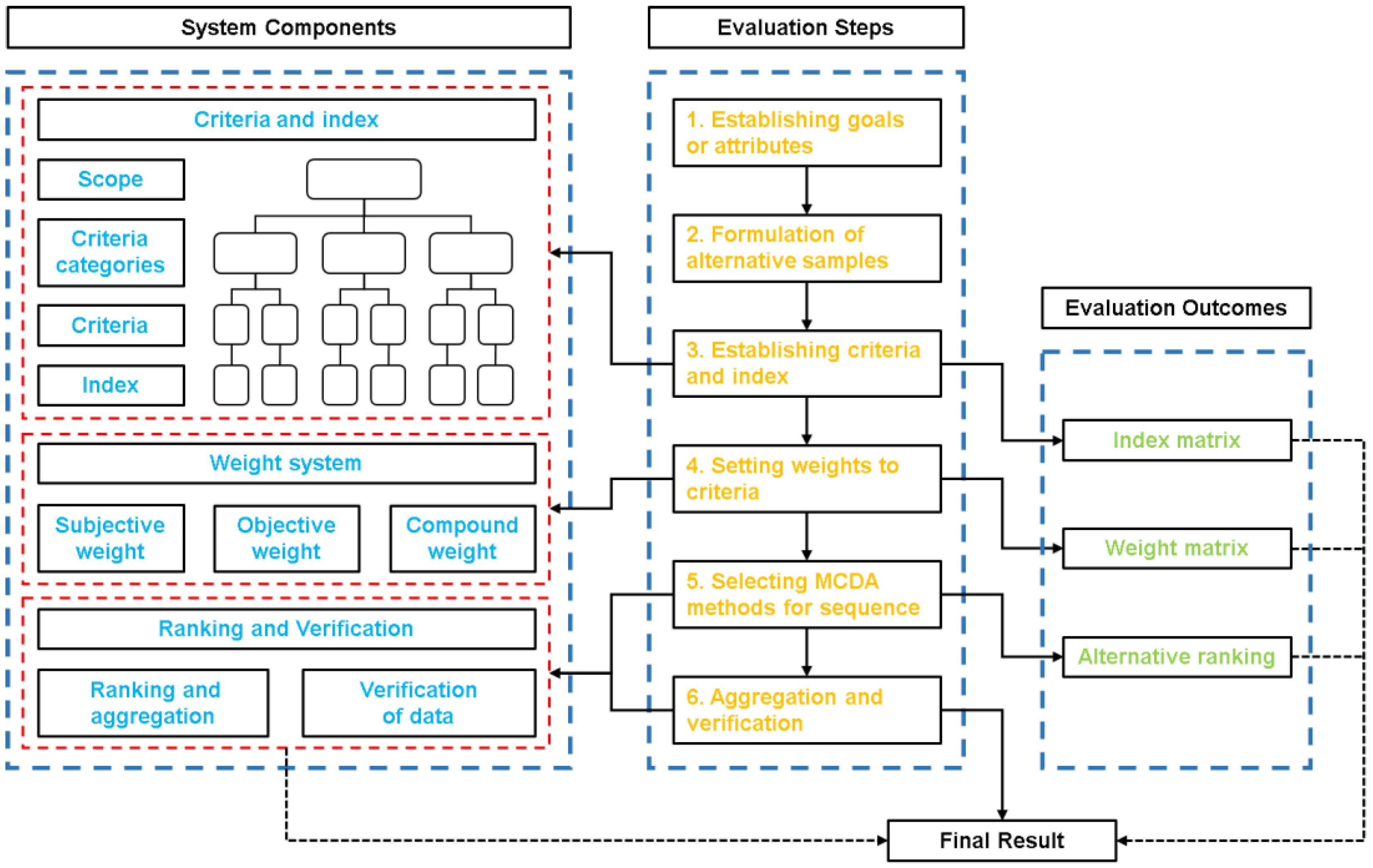
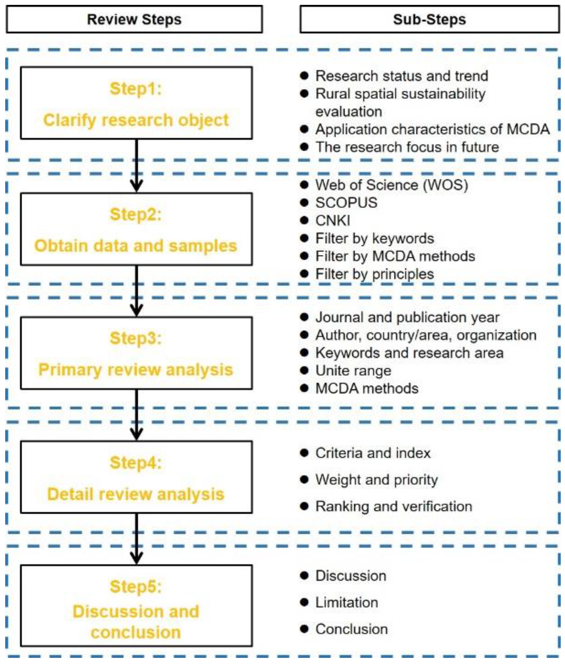
2. Methods and Data Sources
2.1. Classification of MCDA Methods
2.2. Research Structure
2.3. Bibliographic Search Engine Databases
2.4. Data Extraction and Procedures
- (1)
- The definition of the keyword “rural” includes documents that take the suburban, urban–rural border, township, and rural areas as the research scope, and the documents that take the city as the research object alone were not included.
- (2)
- The “space” referred to in this article is the concept of physical space in the category of geography, so the “space” of abstract content involving the universe, network, cogitation, and mathematics is not included in the scope of consideration. Furthermore, the space must be the evaluation object of the research, and the relevant literature must take the exploration of the spatial characteristics as the main purpose. If a study only referred to the research area of the geospatial attribute, and did not make space the evaluation object, it was not included.
- (3)
- Sustainability should be the research target of the considered literature. These studies should identify or improve one or more aspects of rural sustainability through spatial evaluation using the MCDA approach.
3. Primary Review Analysis and Results
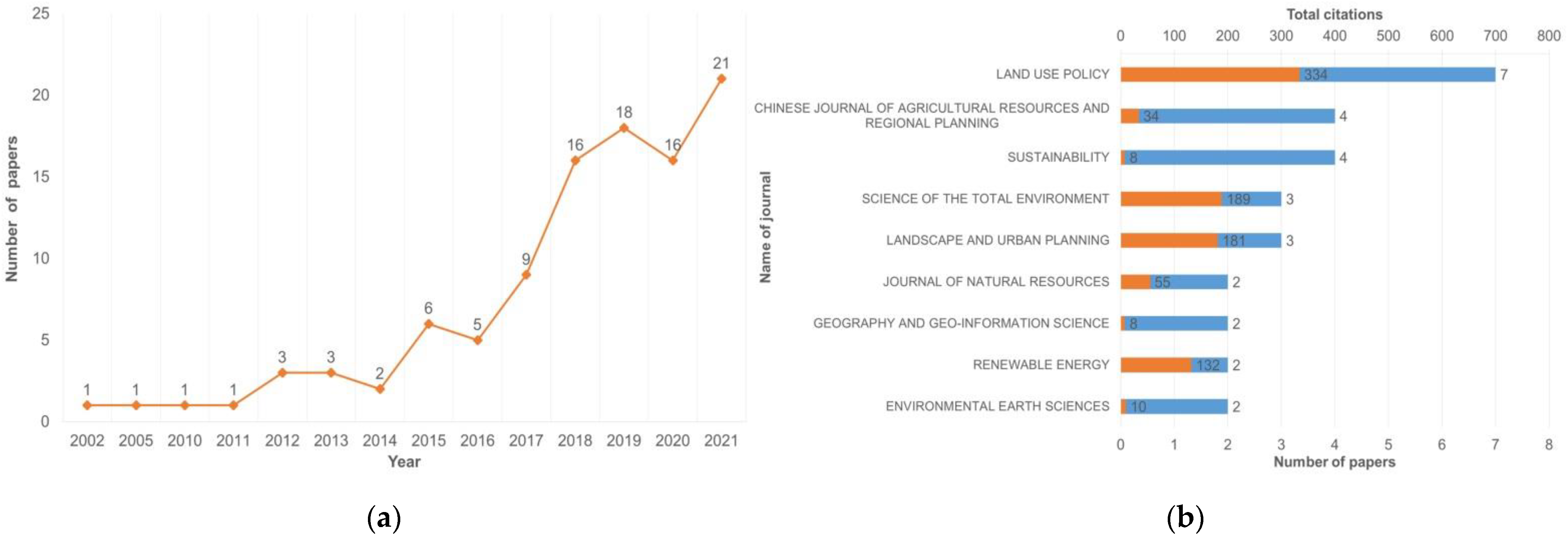
3.1. Journal and Publication Year
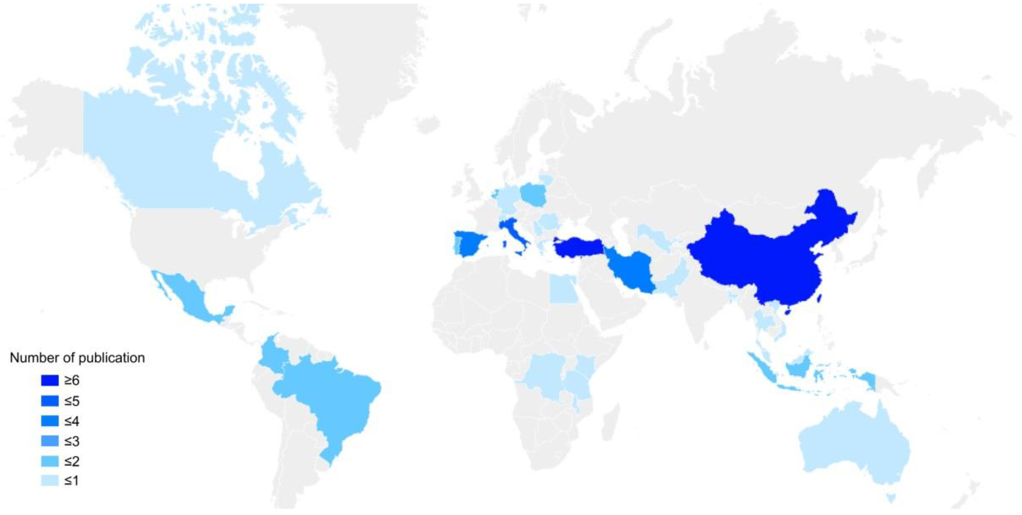
3.2. Author, Organization and Country/Area
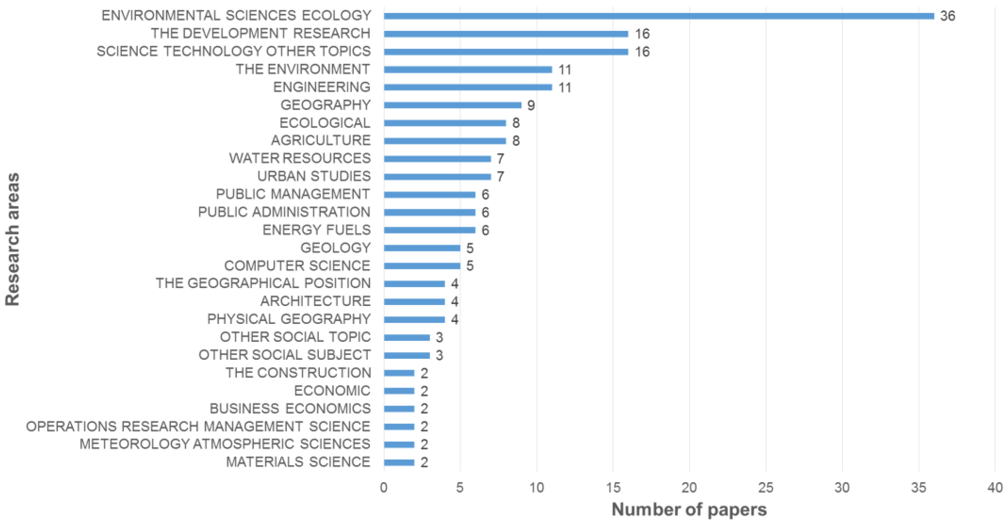
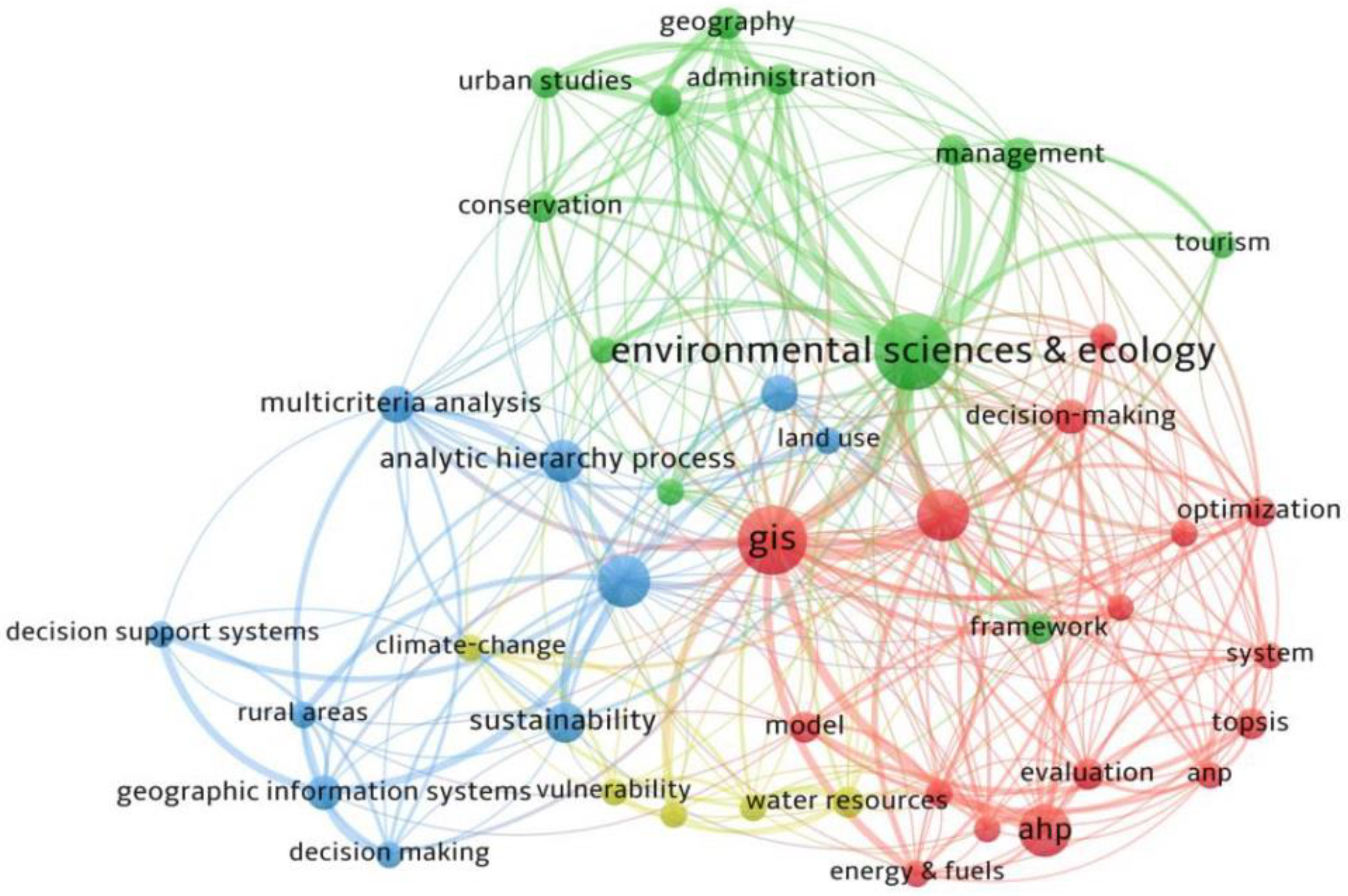
3.3. Keywords and Research Area
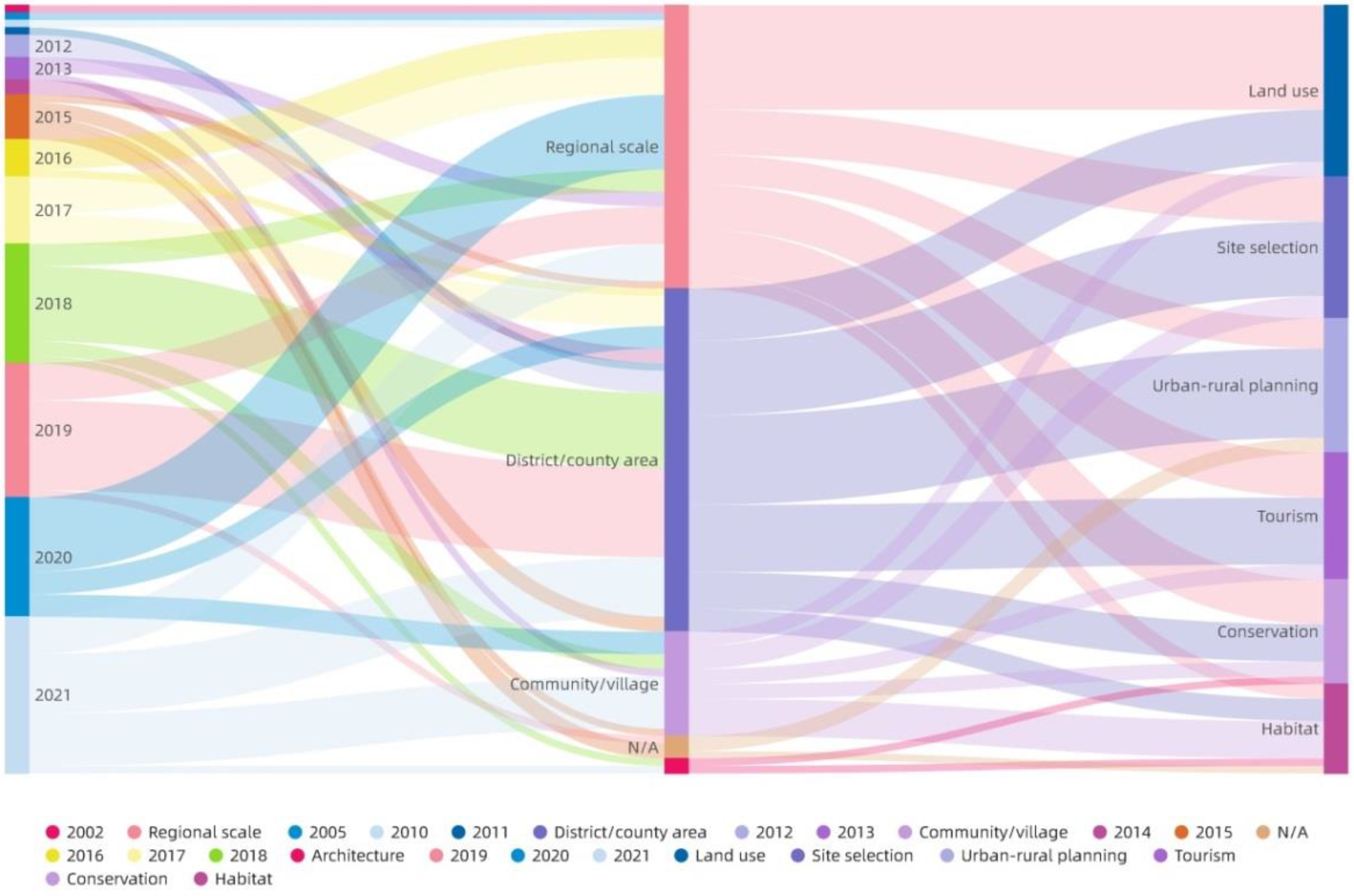
3.4. Unit Range
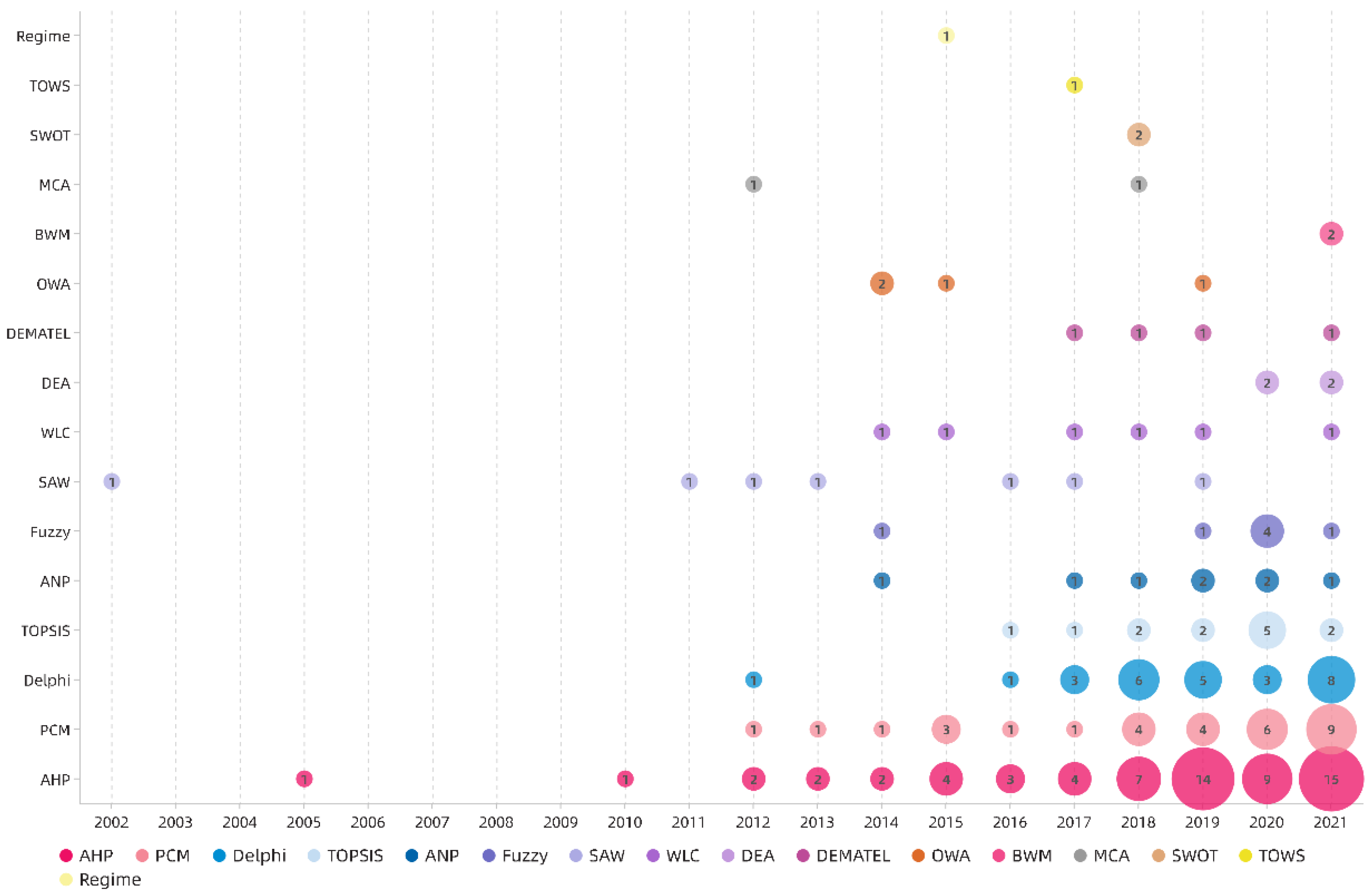
3.5. MCDA Methods
4. Detail Review Analysis and Results
4.1. Criteria and Index
4.1.1. The Formulation of Criteria
Quantitative Analysis of Criteria
Content Analysis of Criteria
4.1.2. Measurement of the Index
Quantitative Analysis of Criteria
Content Analysis of Criteria
4.2. Weight and Priority
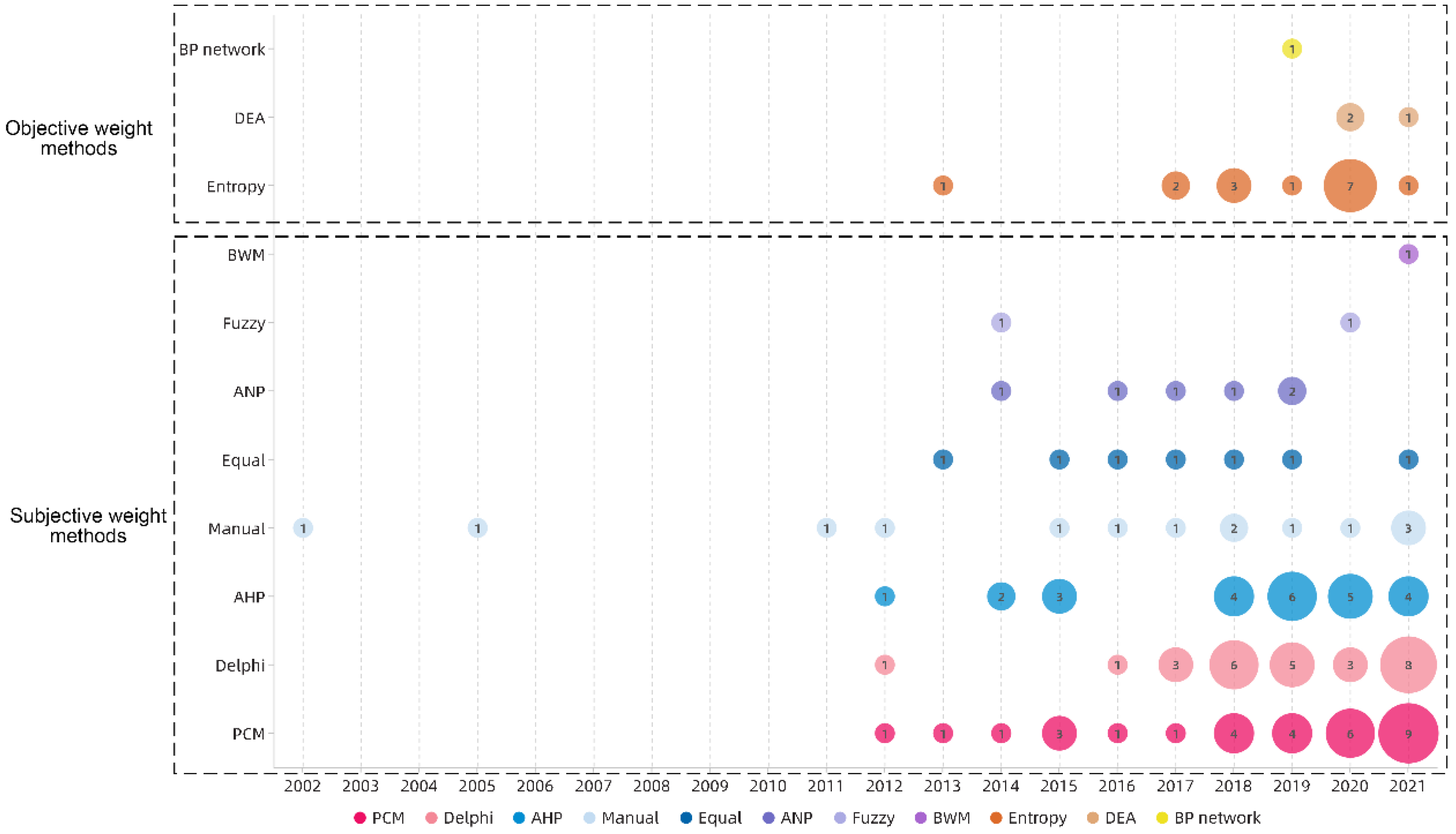
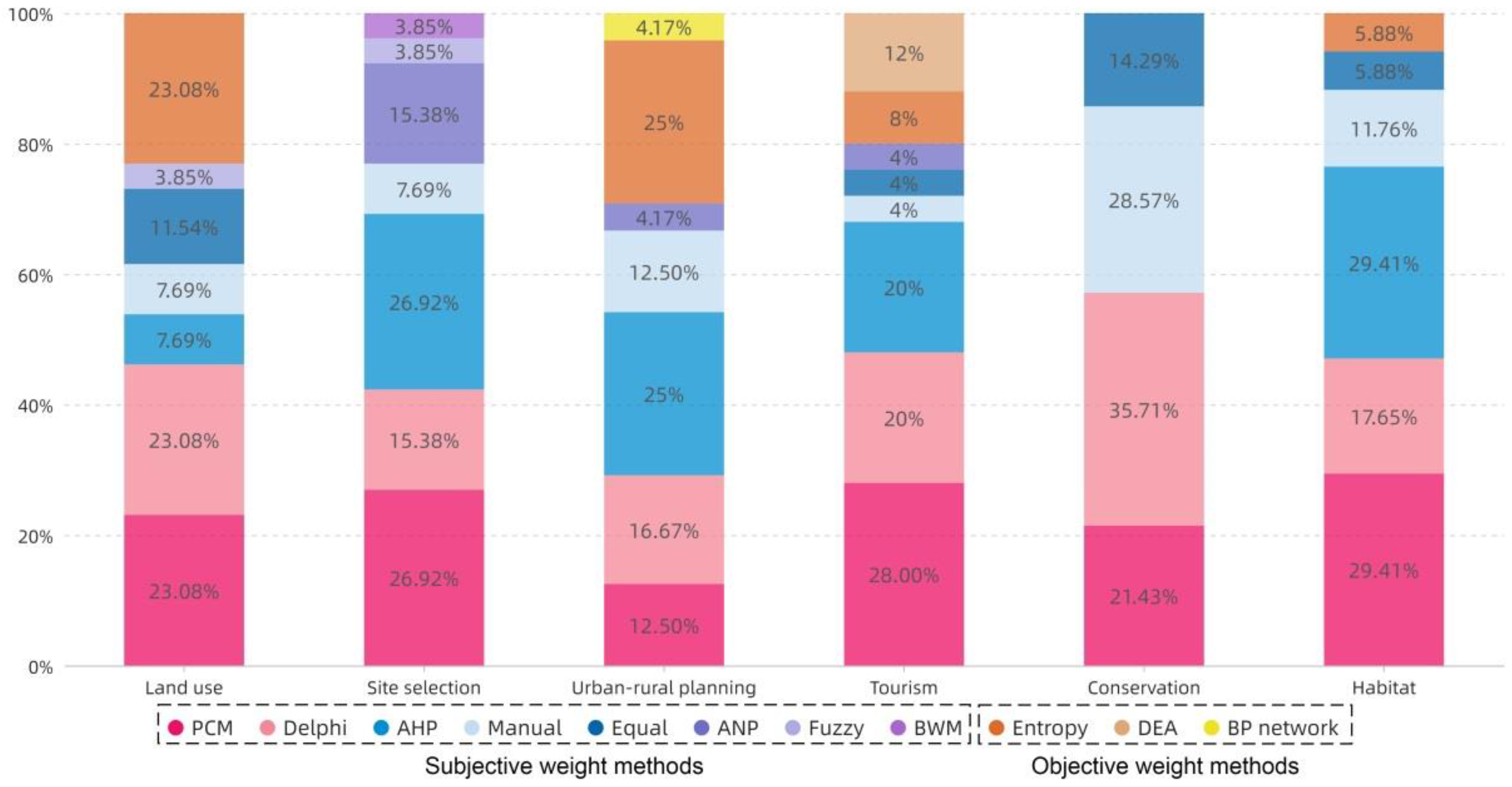
4.2.1. Subjective Weight
4.2.2. Objective Weight
4.2.3. Comprehensive Weight
4.3. Ranking and Verification
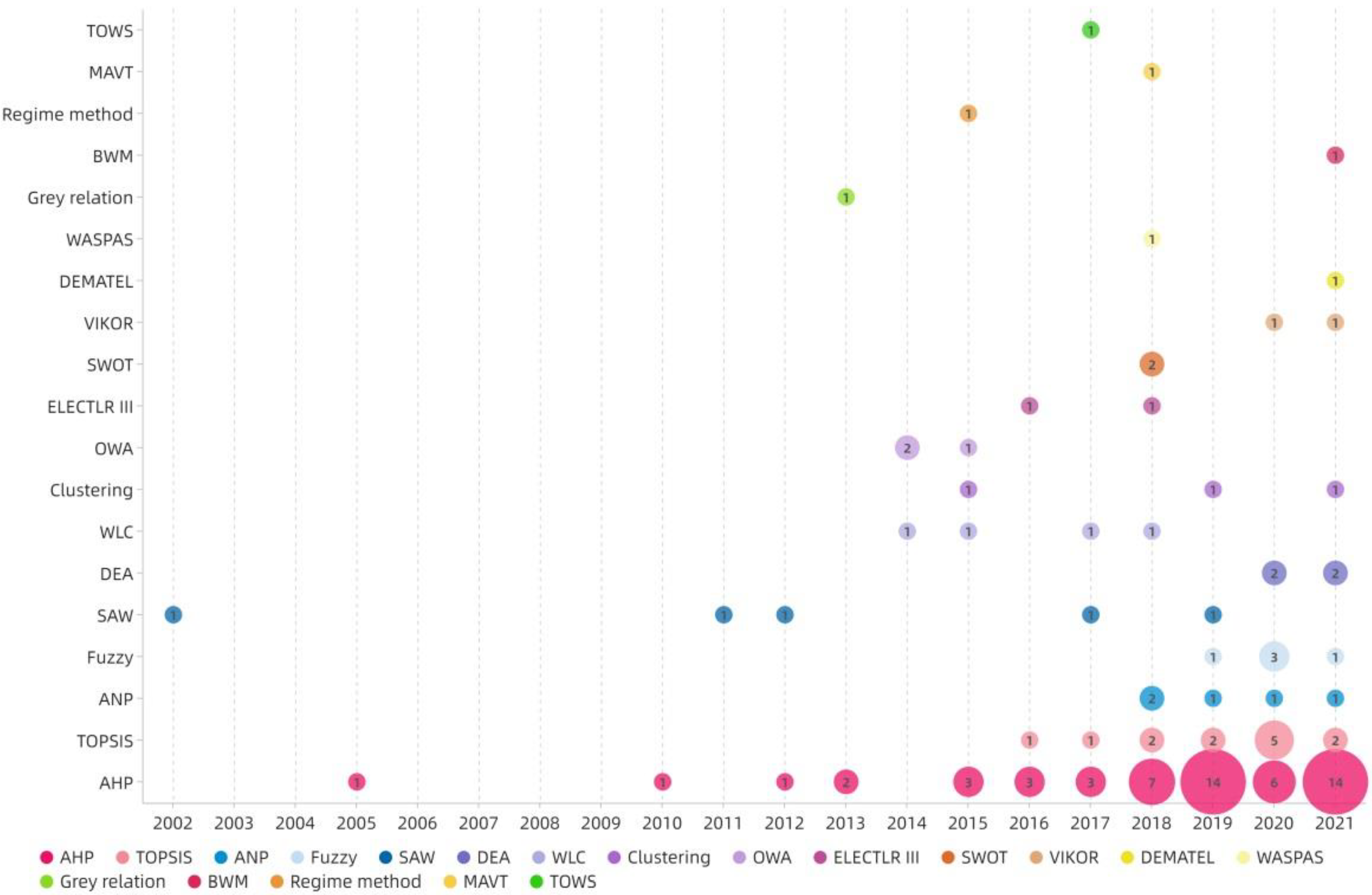
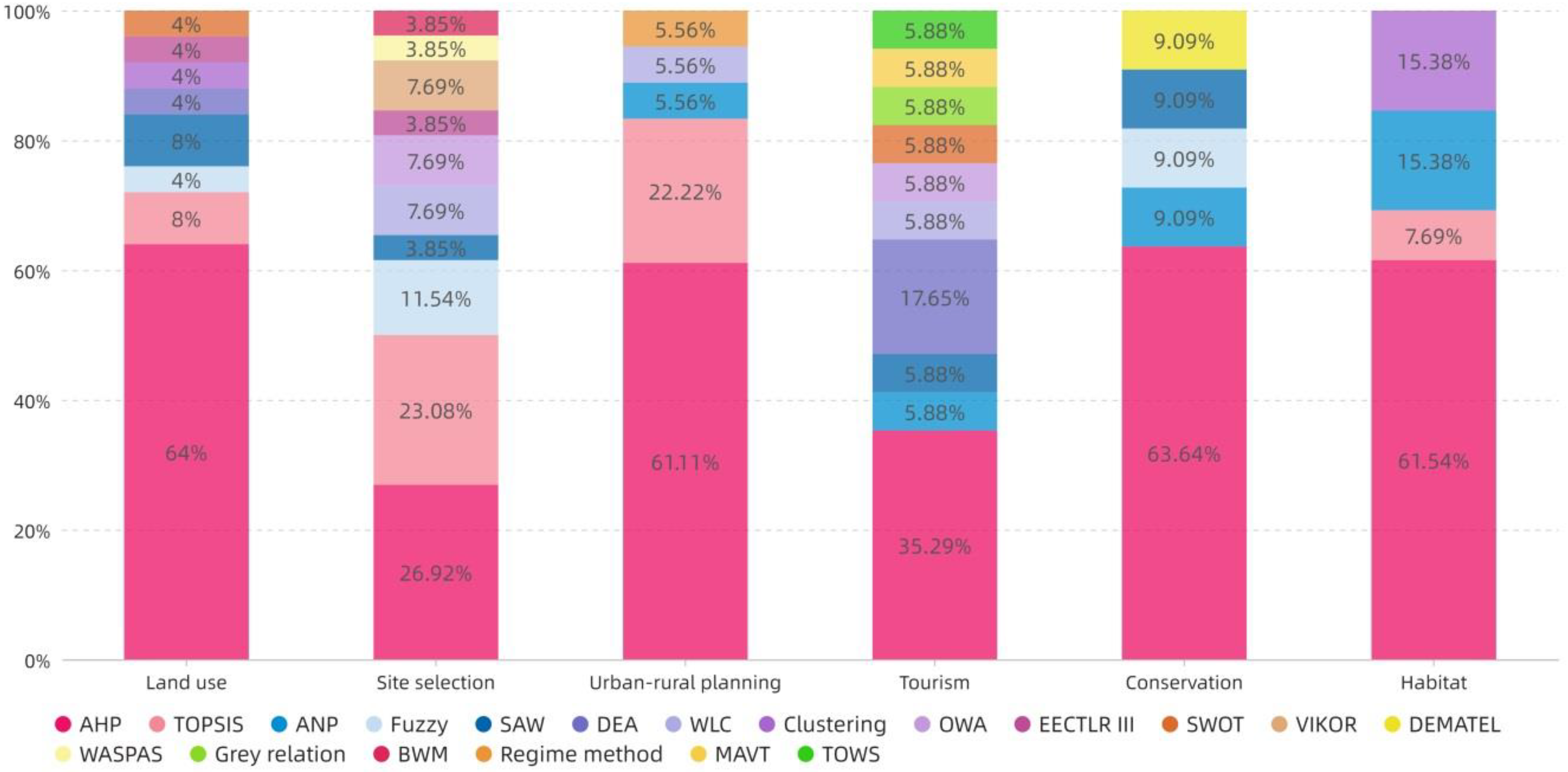
4.3.1. Ranking and Aggregation
Quantitative Analysis of Ranking and Aggregation
Content Analysis of Ranking and Aggregation
4.3.2. Verification of Data
Quantitative Analysis of Verification
Content Analysis of Verification
5. Discussion
5.1. Discussion of the Results in Primary Review Analysis
5.1.1. Overview of Research Trends
5.1.2. Research Topic and Unit Range
5.2. Discussion of the Results in Detail Review Analysis
5.2.1. Criteria Aspects
5.2.2. Feature and Distribution of MCDA Methods
5.3. Limitations
6. Conclusions
- (1)
- During the past 5–8 years, the evaluation of spatial sustainability in rural areas has gradually become a popular research topic due to the worldwide environmental crisis. More research has been published in the Eastern Hemisphere, less in the Western Hemisphere, more in the Northern Hemisphere, and less in the Southern Hemisphere. China, Turkey, and Italy are the three countries producing the most publications. Developing countries or developing regions in developed countries comprise an important zone for related research.
- (2)
- The literature can be divided into six research topics: Land use, Site selection, Urban–rural planning, Tourism, Conservation, and Habitat. The target area of the study consists of four scales: Regional scale, District/county area, Community/village, and Architecture. Macro-scale research is relatively mature, but that of Communities/villages and Architecture is still insufficient.
- (3)
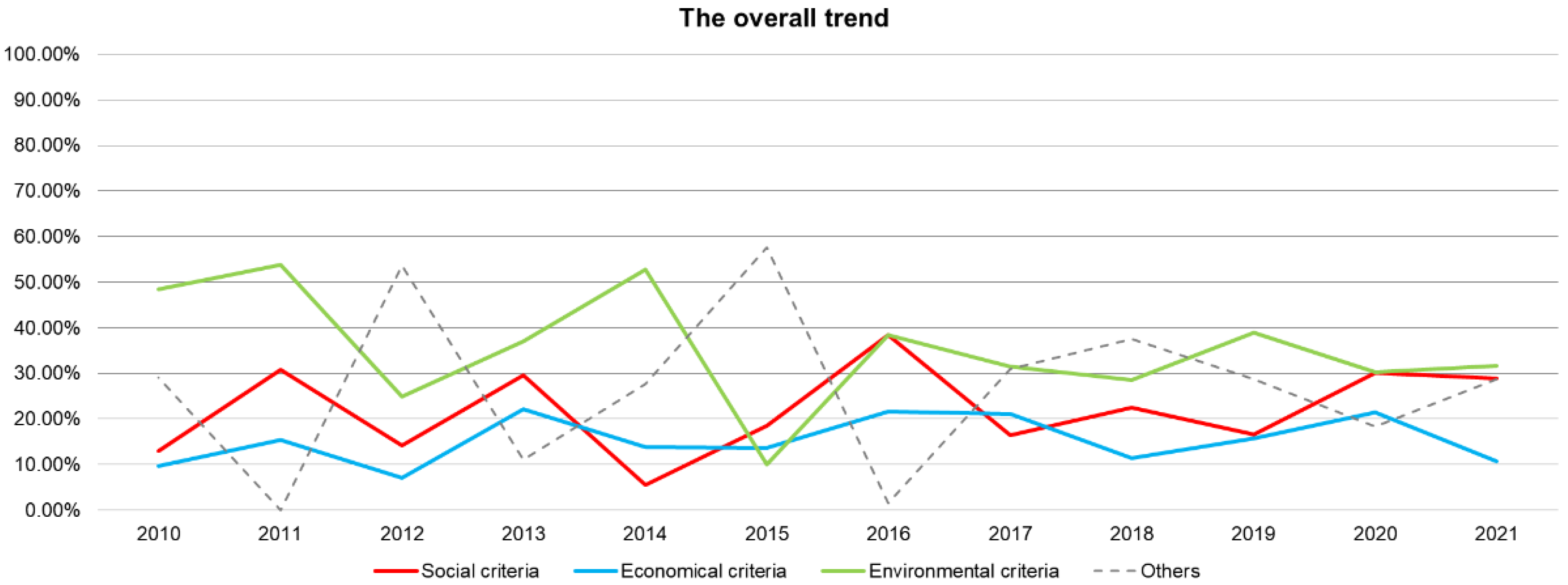
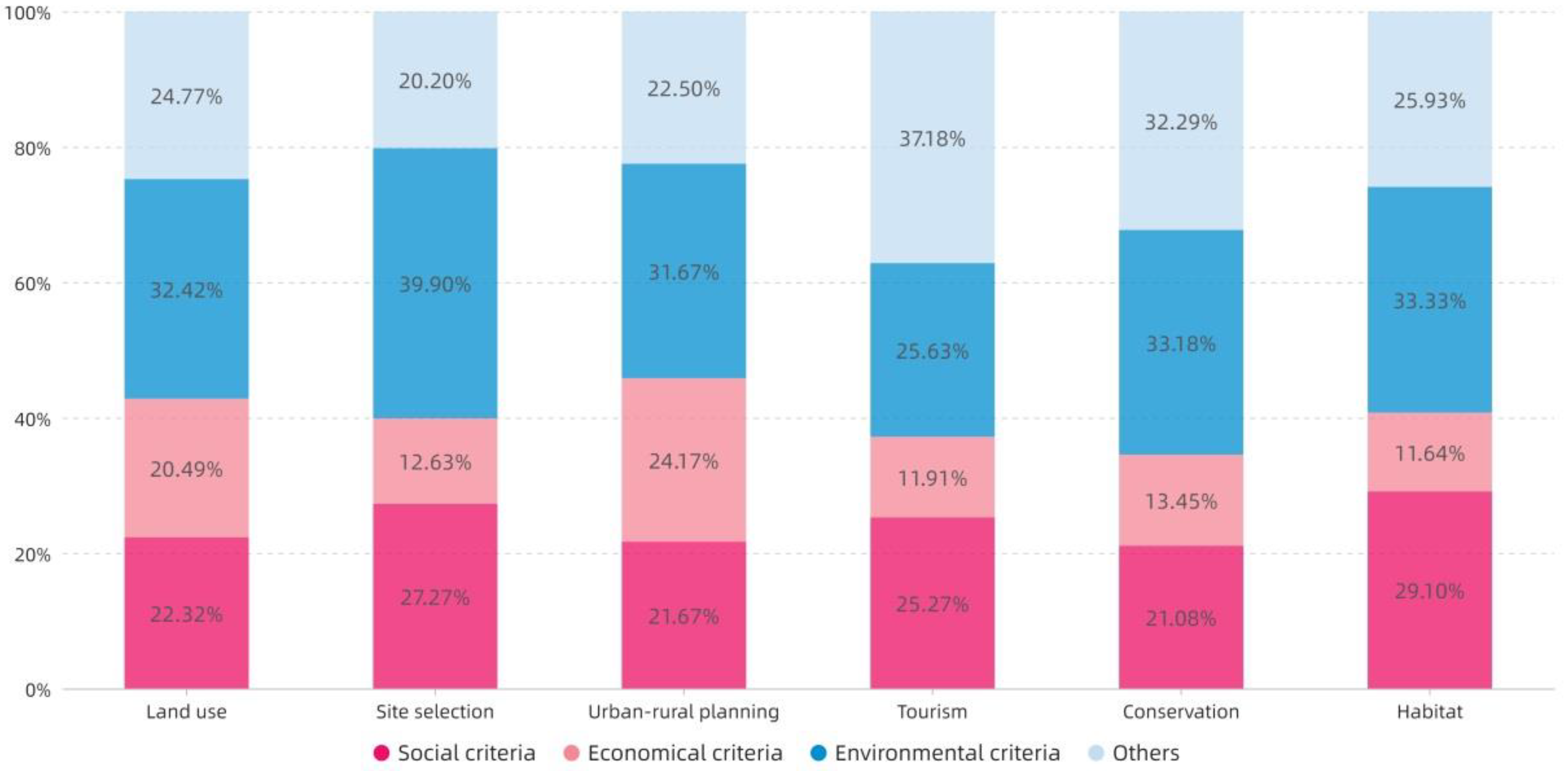
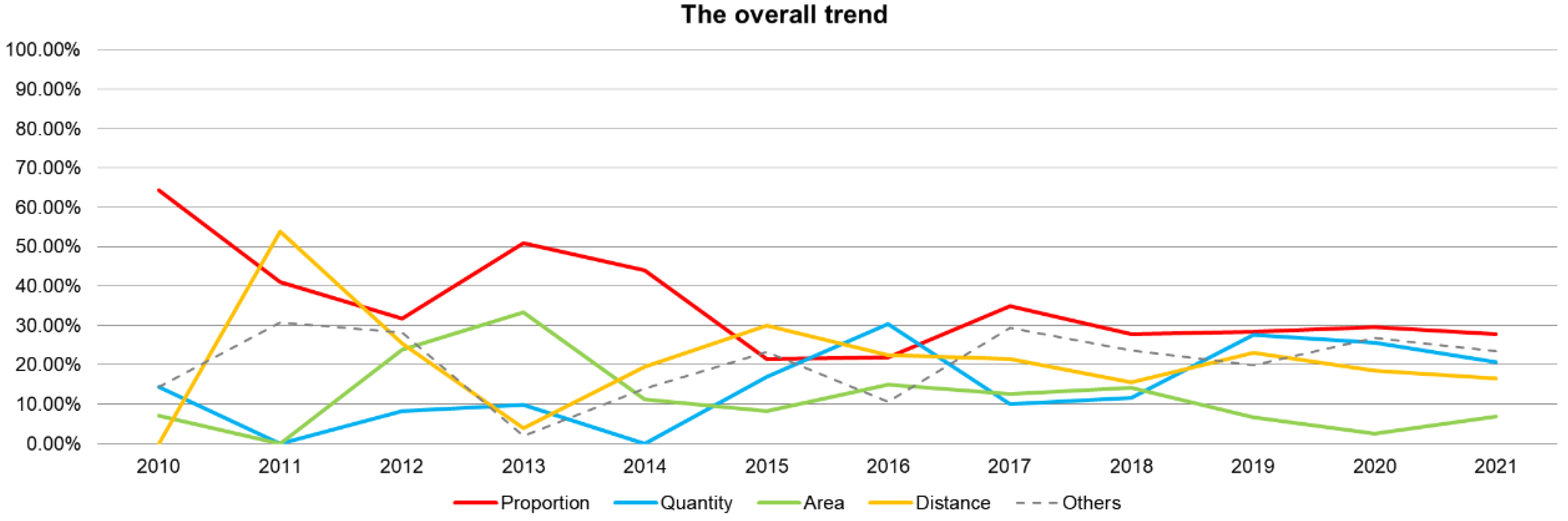
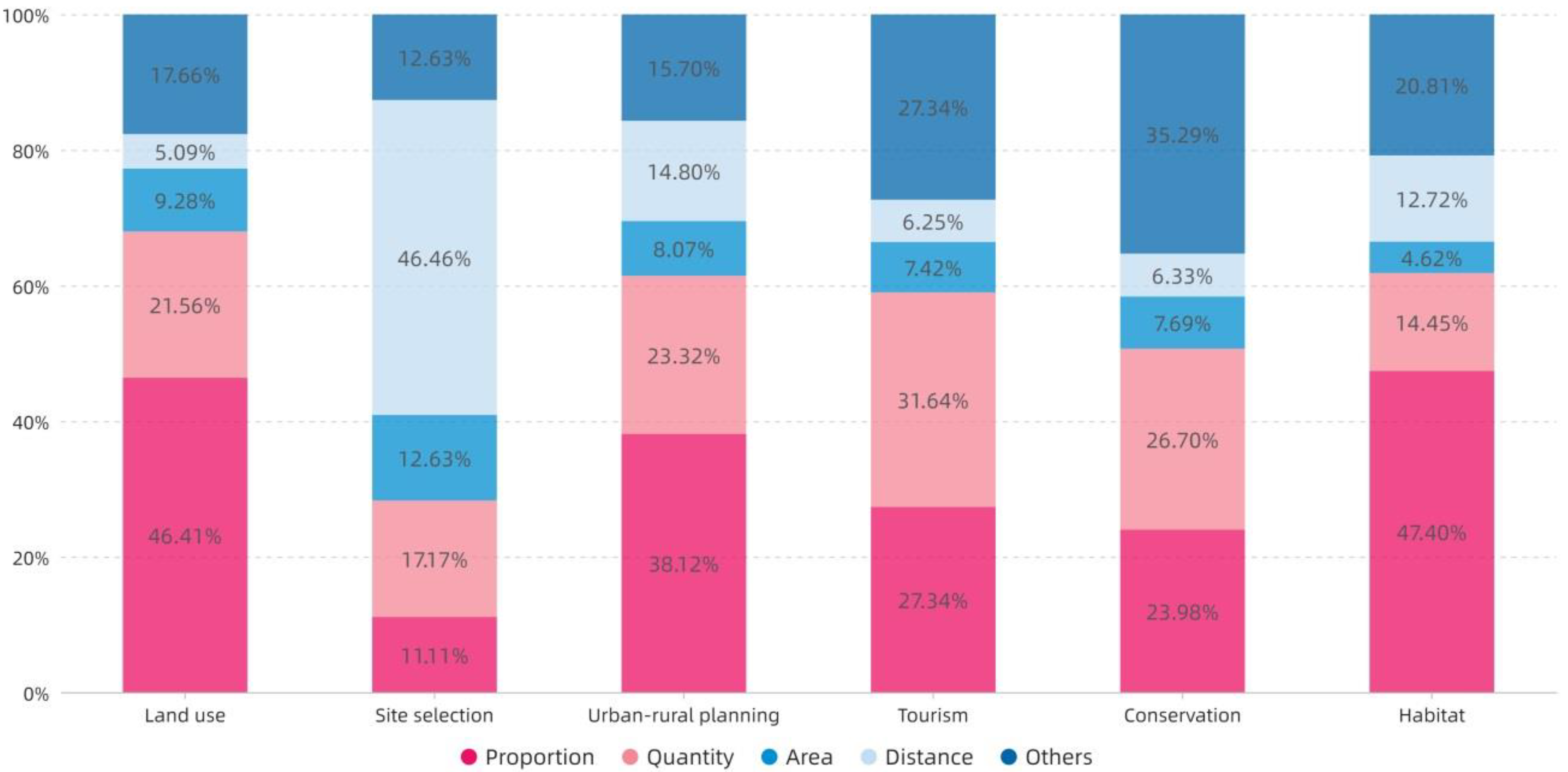
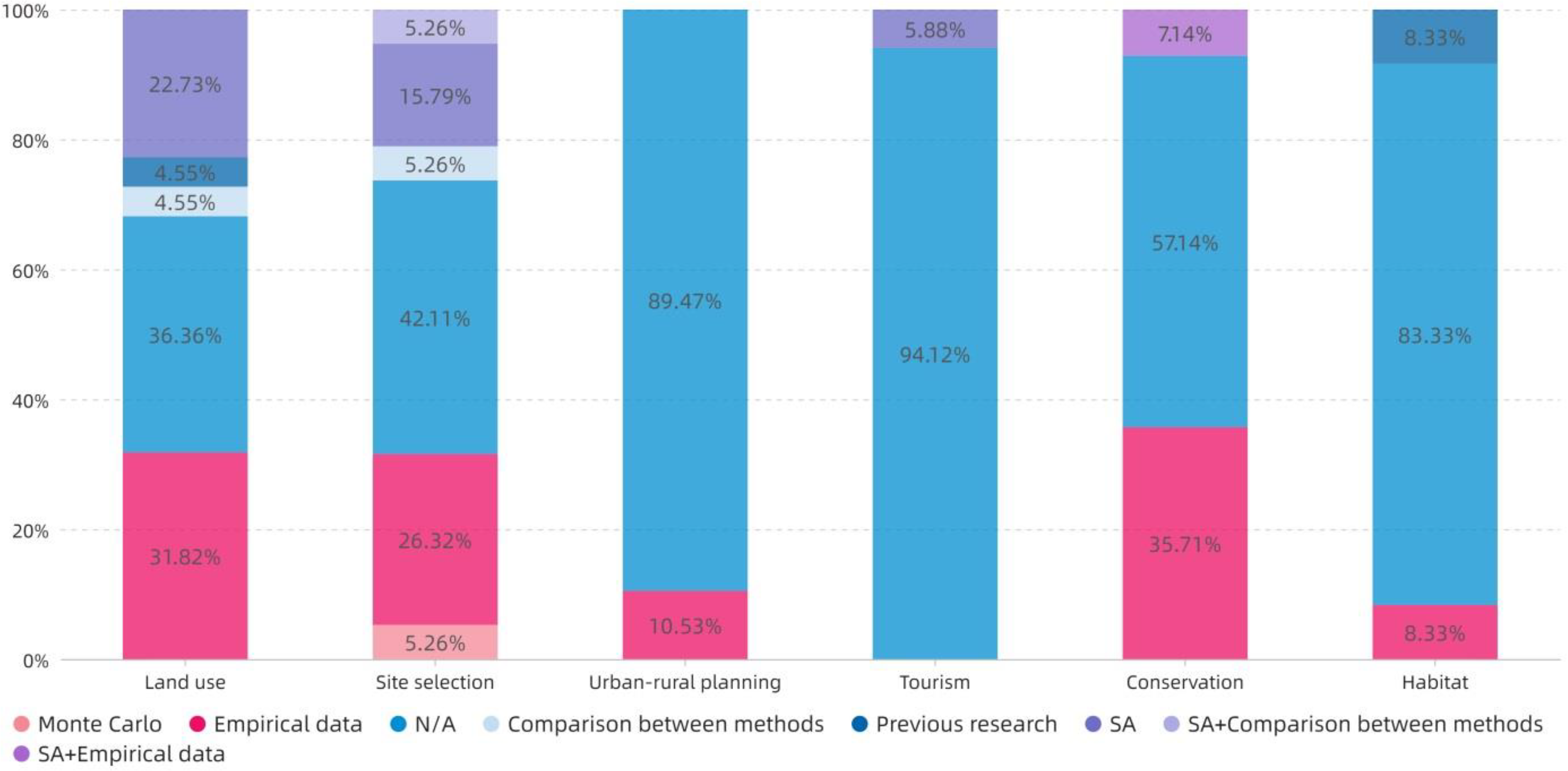
- Due to the urgent needs of the environment, the impact of environmental indicators on research problems and goals should be first considered in the process of criteria formulation. Social and economic criteria are secondary considerations. The contents of other criteria can be formulated with reference to Table 6. Proportion is the most commonly used index type, and Distance is one of the most effective index types in Site selection. The content involved in the index can be formulated with reference to Table 7.
- (4)
- The subjective weighting method is still used in mainstream research, with AHP being the most prominently used approach. Delphi and PCM have excellent applicability in most research topics. For the problems in Site selection and Urban–rural planning, TOPSIS is a more effective MCDA method. Objective weighting is an ideal method for solving problems in Land use, Urban–rural planning, and Tourism. The evaluation of rural spatial sustainability is a very complex problem, and the use of only a single MCDA method has limitations. A hybrid MCDA approach is the preferred option. The Hard Mathematical method can handle most situations, but the Soft Mathematical and Voting methods are recommended for issues involving public participation. The comparative verification of empirical data is a more intuitive method, but when data are lacking, statistical models can be considered.
- (1)
- This study found that, although there are fewer rural studies in developed countries, they are limited by the method and region. Hence, determining the difference in the focus of research on spatial sustainability assessment in developed and developing countries is one of the issues worthy of further study.
- (2)
- In the current research on the evaluation of the sustainability of rural space, the consideration of cultural factors is one of the research gaps. As the core of sustainable development goals, cultural factors need to be paid more attention. Therefore, the research of sustainable space evaluation related to rural cultural heritage will be an important topic for future work.
- (3)
- Against the background of a rapid marginal expansion of related research fields and frequent interdisciplinary penetration, establishing a relatively complete data collection and sharing mechanism within the scope of small- and medium-scale units is basic work that urgently needs to be undertaken in the research on rural spatial sustainability.
- (4)
- Important means to improve the accuracy of rural spatial sustainability evaluation include expanding the types of feasible measurement criteria and indices; increasing the combination of subjective and objective weights; further clarifying the boundary conditions for the use of the deterministic MCDA methods; and adding auxiliary verification for predictive evaluation.
- (5)
- Identifying different characteristics and orientations of rural spatial sustainability research issues, and adopting appropriate quantitative or qualitative MCDA methods, can provide a theoretical basis for formulating a scientific and reasonable evaluation system, so as to provide a decision-making reference for more active and effective promotion of rural sustainable development. The proposal of a scientific and comprehensive MCDA selection list according to research fields, topics, and goals is still an important challenge for future research.
Author Contributions
Funding
Acknowledgments
Conflicts of Interest
Abbreviation
| Abbreviation | Full Name |
| AHP | Analytic Hierarchy Process |
| ANP | Analytic Network Process |
| BWM | Best Worst Method |
| DEA | Data Envelopment Analysis |
| DEMATEL | Decision Making Trial and Evaluation Labotuvary |
| ELECTRE | ELimination Et Choix Traduisant la Realité |
| MAUT | Multi-attribute utility theory |
| MAVT | Multi-attribute value theory |
| OWA | Ordered Weighted Averaging |
| PCA | Principal Component Analysis |
| PCM | Pair-wise Comparison Method |
| SA | Sensitivity Analysis |
| SAW | Simple Additive Weighting |
| SWOT | Strength, Weakness, Opportunity, Threat |
| TOPSIS | Technique for Order Preference by Similarity to an Ideal Solution |
| TOWS | Threat, Opportunity, Weakness, Strength |
| VIKOR | VlseKriterijumska Optimizacija I Kompromisno Resenje |
| WASPAS | Weighted Aggregates Sum Product Assessment |
| WLC | Weighted Linear Combination |
References
- Hofman, K.; Li, X.G. Canada’s energy perspectives and policies for sustainable development. Appl. Energy 2009, 86, 407–415. [Google Scholar] [CrossRef]
- Rist, S.; Chidambaranathan, M.; Escobar, C.; Wiesmann, U.; Zimmermann, A. Moving from sustainable management to sustainable governance of natural resources: The role of social learning processes in rural India, Bolivia and Mali. J. Rural Stud. 2007, 23, 23–37. [Google Scholar] [CrossRef]
- Long, H.L.; Tu, S.S.; Ge, D.Z.; Li, T.T.; Liu, Y.S. The allocation and management of critical resources in rural China under restructuring: Problems and prospects. J. Rural Stud. 2016, 47, 392–412. [Google Scholar] [CrossRef] [Green Version]
- Zhou, W.; Ming, D.P.; Lv, X.W.; Zhou, K.Q.; Bao, H.Q.; Hong, Z.L. SO-CNN based urban functional zone fine division with VHR remote sensing image. Remote Sens. Environ. 2020, 236, 20. [Google Scholar] [CrossRef]
- Meijer, S.S.; Catacutan, D.; Ajayi, O.C.; Sileshi, G.W.; Nieuwenhuis, M. The role of knowledge, attitudes and perceptions in the uptake of agricultural and agroforestry innovations among smallholder farmers in sub-Saharan Africa. Int. J. Agric. Sustain. 2015, 13, 40–54. [Google Scholar] [CrossRef]
- Kim, I.; Arnhold, S. Mapping environmental land use conflict potentials and ecosystem services in agricultural watersheds. Sci. Total Environ. 2018, 630, 827–838. [Google Scholar] [CrossRef]
- Latinopoulos, D.; Theodossiou, N.; Latinopoulos, P. Combined use of groundwater simulation and multi-criteria analysis within a spatial decision-making framework for optimal allocation of irrigation water. Span. J. Agric. Res. 2011, 9, 1105–1119. [Google Scholar] [CrossRef] [Green Version]
- Mishra, S.; Sahu, P.K.; Sarkar, A.K.; Mehran, B.; Sharma, S. Geo-spatial site suitability analysis for development of health care units in rural India: Effects on habitation accessibility, facility utilization and zonal equity in facility distribution. J. Transp. Geogr. 2019, 78, 135–149. [Google Scholar] [CrossRef]
- Elkadeem, M.R.; Younes, A.; Sharshir, S.W.; Campana, P.E.; Wang, S.R. Sustainable siting and design optimization of hybrid renewable energy system: A geospatial multi-criteria analysis. Appl. Energy 2021, 295, 35. [Google Scholar] [CrossRef]
- Jeong, J.S.; Garcia-Moruno, L.; Hernandez-Blanco, J. A site planning approach for rural buildings into a landscape using a spatial multi-criteria decision analysis methodology. Land Use Policy 2013, 32, 108–118. [Google Scholar] [CrossRef]
- Jeong, J.S.; Ramirez-Gomez, A. Development of a web graphic model with fuzzy-decision-making Trial and Evaluation Laboratory/Multi-criteria-Spatial Decision Support System (F-DEMATEL/MC-SDSS) for sustainable planning and construction of rural housings. J. Clean. Prod. 2018, 199, 584–592. [Google Scholar] [CrossRef]
- Reed, M.S. Stakeholder participation for environmental management: A literature review. Biol. Conserv. 2008, 141, 2417–2431. [Google Scholar] [CrossRef]
- Lang, D.J.; Wiek, A.; Bergmann, M.; Stauffacher, M.; Martens, P.; Moll, P.; Swilling, M.; Thomas, C.J. Transdisciplinary research in sustainability science: Practice, principles, and challenges. Sustain. Sci. 2012, 7, 25–43. [Google Scholar] [CrossRef]
- Mardani, A.; Jusoh, A.; Md Nor, K.; Khalifah, Z.; Zakwan, N.; Valipour, A. Multiple criteria decision-making techniques and their applications—A review of the literature from 2000 to 2014. Ekon. Istraz. 2015, 28, 516–571. [Google Scholar] [CrossRef]
- Guitouni, A.; Martel, J.-M. Tentative guidelines to help choosing an appropriate MCDA method. Eur. J. Oper. Res. 1998, 109, 501–521. [Google Scholar] [CrossRef]
- Rezaei, J. Best-worst multi-criteria decision-making method. Omega-Int. J. Manag. Sci. 2015, 53, 49–57. [Google Scholar] [CrossRef]
- Opricovic, S.; Tzeng, G.H. Compromise solution by MCDM methods: A comparative analysis of VIKOR and TOPSIS. Eur. J. Oper. Res. 2004, 156, 445–455. [Google Scholar] [CrossRef]
- Zhang, Z.M.; Sherman, R.; Yang, Z.J.; Wu, R.D.; Wang, W.L.; Yin, M.; Yang, G.H.; Ou, X.K. Integrating a participatory process with a GIS-based multi-criteria decision analysis for protected area zoning in China. J. Nat. Conserv. 2013, 21, 225–240. [Google Scholar] [CrossRef]
- Sharma, M.; Joshi, S.; Kannan, D.; Govindan, K.; Singh, R.; Purohit, H.C. Internet of Things (IoT) adoption barriers of smart cities’ waste management: An Indian context. J. Clean. Prod. 2020, 270, 21. [Google Scholar] [CrossRef]
- Sauri-Riancho, M.R.; Cabanas-Vargas, D.D.; Echeverria-Victoria, M.; Gamboa-Marrufo, M.; Centeno-Lara, R.; Mendez-Novelo, R.I. Locating hazardous waste treatment facilities and disposal sites in the State of Yucatan, Mexico. Environ. Earth Sci. 2011, 63, 351–362. [Google Scholar] [CrossRef]
- Mousavi-Nasab, S.H.; Sotoudeh-Anvari, A. A comprehensive MCDM-based approach using TOPSIS, COPRAS and DEA as an auxiliary tool for material selection problems. Mater. Des. 2017, 121, 237–253. [Google Scholar] [CrossRef]
- Brodny, J.; Tutak, M.; Bindzar, P. Assessing the Level of Renewable Energy Development in the European Union Member States. A 10-Year Perspective. Energies 2021, 14, 38. [Google Scholar] [CrossRef]
- Tsai, J.F.; Wang, C.P.; Chang, K.L.; Hu, Y.C. Selecting Bloggers for Hotels via an Innovative Mixed MCDM Model. Mathematics 2021, 9, 15. [Google Scholar] [CrossRef]
- Kou, G.; Lu, Y.Q.; Peng, Y.; Shi, Y. Evaluation of classification algorithms using mcdm and rank correlation. Int. J. Inf. Technol. Decis. Mak. 2012, 11, 197–225. [Google Scholar] [CrossRef]
- Stojcic, M.; Zavadskas, E.K.; Pamucar, D.; Stevic, Z.; Mardani, A. Application of MCDM Methods in Sustainability Engineering: A Literature Review 2008–2018. Symmetry 2019, 11, 24. [Google Scholar] [CrossRef] [Green Version]
- Saaty, T.L.; Ergu, D.; Making, D. When is a decision-making method trustworthy? Criteria for evaluating multi-criteria decision-making methods. Int. J. Inf. Technol. Decis. Mak. 2015, 14, 1171–1187. [Google Scholar] [CrossRef]
- Gebre, S.L.; Cattrysse, D.; Alemayehu, E.; Van Orshoven, J. Multi-criteria decision making methods to address rural land allocation problems: A systematic review. Int. Soil Water Conserv. Res. 2021, 9, 490–501. [Google Scholar] [CrossRef]
- Mudashiru, R.B.; Sabtu, N.; Abustan, I. Quantitative and semi-quantitative methods in flood hazard/susceptibility mapping: A review. Arab. J. Geosci. 2021, 14, 941. [Google Scholar] [CrossRef]
- Ridha, H.M.; Gomes, C.; Hizam, H.; Ahmadipour, M.; Heidari, A.A.; Chen, H.L. Multi-objective optimization and multi-criteria decision-making methods for optimal design of standalone photovoltaic system: A comprehensive review. Renew. Sust. Energ. Rev. 2021, 135, 23. [Google Scholar] [CrossRef]
- Kumar, A.; Sah, B.; Singh, A.R.; Deng, Y.; He, X.N.; Kumar, P.; Bansal, R.C. A review of multi criteria decision making (MCDM) towards sustainable renewable energy development. Renew. Sust. Energ. Rev. 2017, 69, 596–609. [Google Scholar] [CrossRef]
- Wang, J.J.; Jing, Y.Y.; Zhang, C.F.; Zhao, J.H. Review on multi-criteria decision analysis aid in sustainable energy decision-making. Renew. Sust. Energ. Rev. 2009, 13, 2263–2278. [Google Scholar] [CrossRef]
- Wen, B.H.; Musa, N.; Onn, C.C.; Ramesh, S.; Liang, L.H.; Wang, W. Evolution of sustainability in global green building rating tools. J. Clean. Prod. 2020, 259, 17. [Google Scholar] [CrossRef]
- Lazar, N.; Chithra, K. A comprehensive literature review on development of Building Sustainability Assessment Systems. J. Build. Eng. 2020, 32, 16. [Google Scholar] [CrossRef]
- Perez, J.C.; Carrillo, M.H.; Montoya-Torres, J.R. Multi-criteria approaches for urban passenger transport systems: A literature review. Ann. Oper. Res. 2015, 226, 69–87. [Google Scholar] [CrossRef]
- Wang, T.-C.; Lee, H.-D. Developing a fuzzy TOPSIS approach based on subjective weights and objective weights. Expert Syst. Appl. 2009, 36, 8980–8985. [Google Scholar] [CrossRef]
- Saaty, T.L. The Analytic Hierarchy Process; McGraw Hill: New York, NY, USA, 1980. [Google Scholar]
- Saarikoski, H.; Mustajoki, J.; Barton, D.N.; Geneletti, D.; Langemeyer, J.; Gomez-Baggethun, E.; Marttunen, M.; Antunes, P.; Keune, H.; Santos, R. Multi-Criteria Decision Analysis and Cost-Benefit Analysis: Comparing alternative frameworks for integrated valuation of ecosystem services. Ecosyst. Serv. 2016, 22, 238–249. [Google Scholar] [CrossRef]
- Cleophas, T.J.; Cleophas, T.F. Artificial intelligence for diagnostic purposes: Principles, procedures and limitations. Clin. Chem. Lab. Med. 2010, 48, 159–165. [Google Scholar] [CrossRef]
- Aboutorab, H.; Saberi, M.; Asadabadi, M.R.; Hussain, O.; Chang, E. ZBWM: The Z-number extension of Best Worst Method and its application for supplier development. Expert Syst. Appl. 2018, 107, 115–125. [Google Scholar] [CrossRef]
- Guo, S.; Zhao, H. Fuzzy best-worst multi-criteria decision-making method and its applications. Knowl.-Based Syst. 2017, 121, 23–31. [Google Scholar] [CrossRef]
- Liu, J.S.; Lu, L.Y.Y.; Lu, W.-M.; Lin, B.J.Y. Data envelopment analysis 1978–2010: A citation-based literature survey. Omega 2013, 41, 3–15. [Google Scholar] [CrossRef]
- Rowe, G.; Wright, G. Expert Opinions in Forecasting: The Role of the Delphi Technique. In Principles of Forecasting; Springer: Boston, MA, USA, 2001. [Google Scholar]
- Si, S.L.; You, X.Y.; Liu, H.C.; Zhang, P. DEMATEL Technique: A Systematic Review of the State-of-the-Art Literature on Methodologies and Applications. Math. Probl. Eng. 2018, 2018, 33. [Google Scholar] [CrossRef] [Green Version]
- Almeida-Dias, J.; Figueira, J.R.; Roy, B. Electre Tri-C: A multiple criteria sorting method based on characteristic reference actions. Eur. J. Oper. Res. 2010, 204, 565–580. [Google Scholar] [CrossRef] [Green Version]
- Daneshvar Rouyendegh, B.; Erol, S. Selecting the Best Project Using the Fuzzy ELECTRE Method. Math. Probl. Eng. 2012, 2012, 790142. [Google Scholar] [CrossRef]
- Zou, Z.-H.; Yun, Y.; Sun, J.-N. Entropy method for determination of weight of evaluating indicators in fuzzy synthetic evaluation for water quality assessment. J. Environ. Sci. 2006, 18, 1020–1023. [Google Scholar] [CrossRef]
- Goguen, J.; Zadeh, L.A. Fuzzy sets. Information and control, vol. 8 (1965), pp. 338–353. - L. A. Zadeh. Similarity relations and fuzzy orderings. Information sciences, vol. 3 (1971), pp. 177–200. J. Symb. Log. 1973, 38, 656–657. [Google Scholar] [CrossRef]
- Lin, Y.; Liu, S. A Historical Introduction to Grey Systems Theory. In Proceedings of the 2004 IEEE International Conference on Systems, Man and Cybernetics, The Hague, The Netherlands, 10–13 October 2004. [Google Scholar]
- Belton, V.; Stewart, T. Multiple Criteria Decision Analysis:An Integrated Approach; Springer Science & Business Media: Berlin/Heidelberg, Germany, 2002. [Google Scholar]
- Malczewski, J. Ordered weighted averaging with fuzzy quantifiers: GIS-based multicriteria evaluation for land-use suitability analysis. Int. J. Appl. Earth Obs. Geoinf. 2006, 8, 270–277. [Google Scholar] [CrossRef]
- Gorsevski, P.V.; Donevska, K.R.; Mitrovski, C.D.; Frizado, J.P. Integrating multi-criteria evaluation techniques with geographic information systems for landfill site selection: A case study using ordered weighted average. Waste Manag. 2012, 32, 287–296. [Google Scholar] [CrossRef]
- Bro, R.; Smilde, A.K. Principal component analysis. Anal. Methods 2014, 6, 2812–2831. [Google Scholar] [CrossRef] [Green Version]
- Hinloopen, E.; Nijkamp, P.; Rietveld, P. Qualitative discrete multiple criteria choice models in regional planning. Reg. Sci. Urban Econ. 1983, 13, 77–102. [Google Scholar] [CrossRef]
- Nijkamp, P.; Pepping, G. A meta-analytical evaluation of sustainable city initiatives. Urban Stud. 1998, 35, 1481–1500. [Google Scholar] [CrossRef]
- Windarto, A.; Muhammad, A. Comparison of Weighted Sum Model and Multi Attribute Decision Making Weighted Product Methods in Selecting the Best Elementary School in Indonesia. Int. J. Softw. Eng. Appl. 2017, 11, 69–90. [Google Scholar]
- Hill, T.; Westbrook, R. SWOT analysis: It’s time for a product recall. Long Range Plan. 1997, 30, 46–52. [Google Scholar] [CrossRef]
- Phadermrod, B.; Crowder, R.M.; Wills, G.B. Importance-Performance Analysis based SWOT analysis. Int. J. Inf. Manag. 2019, 44, 194–203. [Google Scholar] [CrossRef] [Green Version]
- Rao, R.V. Decision Making in the Manufacturing Environment Using Graph Theory and Fuzzy Multiple Attribute Decision Making Methods; Springer: London, UK, 2007. [Google Scholar]
- Weihrich, H. The TOWS matrix—A tool for situational analysis. Long Range Plan. 1982, 15, 54–66. [Google Scholar] [CrossRef]
- Opricovic, S. Belgrade, Multicriteria optimization of civil engineering systems. Fac. Civ. Eng. Belgrade 1998, 2, 5–21. [Google Scholar]
- Sałabun, W.; Wątróbski, J.; Shekhovtsov, A. Are mcda methods benchmarkable? a comparative study of topsis, vikor, copras, and promethee ii methods. Symmetry 2020, 12, 1549. [Google Scholar] [CrossRef]
- Zavadskas, E.K.; Turskis, Z.; Antucheviciene, J.; Zakarevicius, A. Optimization of weighted aggregated sum product assessment. Elektron. Elektrotech. 2012, 122, 3–6. [Google Scholar] [CrossRef]
- Marler, R.T.; Arora, J.S. The weighted sum method for multi-objective optimization: New insights. Struct. Multidiscip. Optim. 2010, 41, 853–862. [Google Scholar] [CrossRef]
- Wallin, J.A. Bibliometric methods: Pitfalls and possibilities. Basic Clin. Pharmacol. Toxicol. 2005, 97, 261–275. [Google Scholar] [CrossRef]
- Nasir Ahmad, N.S.B.; Mustafa, F.B.; Muhammad Yusoff, S.Y.; Didams, G. A systematic review of soil erosion control practices on the agricultural land in Asia. Int. Soil Water Conserv. Res. 2020, 8, 103–115. [Google Scholar] [CrossRef]
- Harzing, A.-W.; Alakangas, S. Google Scholar, Scopus and the Web of Science: A longitudinal and cross-disciplinary comparison. Scientometrics 2016, 106, 787–804. [Google Scholar] [CrossRef]
- Fu, P.F.; Guo, X.B.; Cheung, F.M.H.; Yung, K.K.L. The association between PM2.5 exposure and neurological disorders: A systematic review and meta-analysis. Sci. Total Environ. 2019, 655, 1240–1248. [Google Scholar] [CrossRef] [PubMed]
- Agriculture & Rural Development, 2021 ed.; The World Bank: Washington, DC, USA, 2021.
- McGowan, J.; Sampson, M. Systematic reviews need systematic searchers. J. Med. Libr. Assoc. 2005, 93, 74–80. [Google Scholar]
- Boeker, M.; Vach, W.; Motschall, E. Google Scholar as replacement for systematic literature searches: Good relative recall and precision are not enough. BMC Med. Res. Methodol. 2013, 13, 131. [Google Scholar] [CrossRef] [PubMed] [Green Version]
- Liberati, A.; Altman, D.G.; Tetzlaff, J.; Mulrow, C.; Gøtzsche, P.C.; Ioannidis, J.P.A.; Clarke, M.; Devereaux, P.J.; Kleijnen, J.; Moher, D. The PRISMA statement for reporting systematic reviews and meta-analyses of studies that evaluate health care interventions: Explanation and elaboration. J. Clin. Epidemiol. 2009, 62, e1–e34. [Google Scholar] [CrossRef] [PubMed] [Green Version]
- Page, M.J.; McKenzie, J.E.; Bossuyt, P.M.; Boutron, I.; Hoffmann, T.C.; Mulrow, C.D.; Shamseer, L.; Tetzlaff, J.M.; Akl, E.A.; Brennan, S.E.; et al. The PRISMA 2020 statement: An updated guideline for reporting systematic reviews. Syst. Rev. 2021, 10, 89. [Google Scholar] [CrossRef]
- Nadkarni, R.R.; Puthuvayi, B. A comprehensive literature review of Multi-Criteria Decision Making methods in heritage buildings. J. Build. Eng. 2020, 32, 14. [Google Scholar] [CrossRef]
- Zuluaga, A.; Etter, A.; Nepstad, D.; Chará, J.; Stickler, C.; Warren, M. Colombia’s pathway to a more sustainable cattle sector: A spatial multi-criteria analysis. Land Use Policy 2021, 109, 105596. [Google Scholar] [CrossRef]
- Zrobek, S.; Kovalyshyn, O.; Renigier-Bilozor, M.; Kovalyshyn, S.; Kovalyshyn, O. Fuzzy logic method of valuation supporting sustainable development of the agricultural land market. Sustain. Dev. 2020, 28, 1094–1105. [Google Scholar] [CrossRef]
- Zhou, Y.; Guo, L.Y.; Liu, Y.S. Land consolidation boosting poverty alleviation in China: Theory and practice. Land Use Policy 2019, 82, 339–348. [Google Scholar] [CrossRef]
- Zhou, D.; Xu, J.C.; Lin, Z.L. Conflict or coordination? Assessing land use multi-functionalization using production-living-ecology analysis. Sci. Total Environ. 2017, 577, 136–147. [Google Scholar] [CrossRef] [PubMed]
- Zhou, B.Y.; Liu, W.X.; Lu, W.N.; Zhao, M.J.; Li, L.F. Application of OECD LSE Framework to Assess Spatial Differences in Rural Green Development in the Arid Shaanxi Province, China. Int. J. Environ. Res. Public Health 2020, 17, 22. [Google Scholar] [CrossRef] [PubMed] [Green Version]
- Zhang, Q.-Q.; Liao, H.-P.; Yang, W.; Zhang, Y.-F.; Long, H. Evaluation of Rural Land Use Transformation Based on the Entropy Weight TOPSIS Model—A Case Study of Yubei District, Chongqing. J. Southwest Univ. (Nat. Sci. Ed.) 2018, 40, 135–144. [Google Scholar]
- Zhang, H.; Chen, H.; Geng, T.-W.; Shi, Q.-Q.; Liu, D. Spatial Differentiations and Influential Factors of Famers’ Livelihood Resilience in Loess Hilly-Gully Region: A Case Study of Shigou Township in Mizhi County of Northern Shaanxi. Geogr. Geo-Inf. Sci. 2020, 36, 100–106. [Google Scholar]
- Zhang, G.; Li, X.; Wu, J.; MA, J. Ecological sensitivity in Sanlin Village, Huzhou City in the context of rural revitalization. J. Zhejiang Agric. Sci. 2021, 62, 627–631. [Google Scholar]
- van Leeuwen, J.P.; Creamer, R.E.; Cluzeau, D.; Debeljak, M.; Gatti, F.; Henriksen, C.B.; Kuzmanovski, V.; Menta, C.; Peres, G.; Picaud, C.; et al. Modeling of Soil Functions for Assessing Soil Quality: Soil Biodiversity and Habitat Provisioning. Front. Environ. Sci. 2019, 7, 13. [Google Scholar] [CrossRef]
- Schaefer, M.; Thinh, N.X. Evaluation of Land Cover Change and Agricultural Protection Sites: A GIS and Remote Sensing Approach for Ho Chi Minh City, Vietnam. Heliyon 2019, 5, 14. [Google Scholar] [CrossRef] [Green Version]
- Rodrigues, G.S.; Rodrigues, I.A.; Buschinelli, C.C.D.; de Barros, I. Integrated farm sustainability assessment for the environmental management of rural activities. Environ. Impact Assess. Rev. 2010, 30, 229–239. [Google Scholar] [CrossRef]
- Ren, G.-P.; Liu, L.-M.; Li, H.-Q.; Yin, G. Study on Spatial-temporal Collocation of Integrated Territory Consolidation Based on Rural Social-ecological System Vulnerability. J. Ecol. Rural Environ. 2021, 37, 1318–1330. [Google Scholar]
- Rahmoun, T.; Zhao, W.; Hammad, M.; Hassan, M. Ruralization vs. Urbanization Sprawl as Guiding Regional Planning: Development Scenario for Rivers Watershed in the Southern Syrian Coastal Region. In Proceedings of the 9th International Conference on Environmental Science and Development (ICESD), Paris, France, 7–9 February 2018; Iop Publishing Ltd.: Paris, France, 2018. [Google Scholar]
- Jiang, S.; Meng, J.; Zhu, L. Spatial and temporal analyses of potential land use conflict under the constraints of water resources in the middle reaches of the Heihe River. Land Use Policy 2020, 97, 104773. [Google Scholar] [CrossRef]
- Hill, M.J.; Braaten, R.; Veitch, S.M.; Lees, B.G.; Sharma, S. Multi-criteria decision analysis in spatial decision support: The ASSESS analytic hierarchy process and the role of quantitative methods and spatially explicit analysis. Environ. Model. Softw. 2005, 20, 955–976. [Google Scholar] [CrossRef]
- Hassani, Y.; Shandany, S.M.H.; Maestre, J.M.; Zahraie, B.; Ghorbani, M.; Henneberry, S.R.; Kulshreshtha, S.N. An economic-operational framework for optimum agricultural water distribution in irrigation districts without water marketing. Agric. Water Manag. 2019, 221, 348–361. [Google Scholar] [CrossRef]
- Gurrutxaga, M. Changes in rural-urban sex ratio differences in the young professional age group as an indicator of social sustainability in rural areas: A case study of continental Spain, 2000–2010. Area 2013, 45, 337–347. [Google Scholar] [CrossRef]
- Geri, F.; Sacchelli, S.; Bernetti, I.; Ciolli, M. Urban-rural bioenergy planning as a strategy for the sustainable development of inner areas: A GIS-based method to chance the forest chain. In Green Energy and Technology; Springer: Berlin/Heidelberg, Germany, 2018; pp. 539–550. [Google Scholar]
- Demetriou, D.; Stillwell, J.; See, L. A new methodology for measuring land fragmentation. Comput. Environ. Urban Syst. 2013, 39, 71–80. [Google Scholar] [CrossRef] [Green Version]
- Cui, Y.; Long, Y.-L. Study on Village-industry Integration Based on AHP-fuzzy Comprehensive Evaluation in Rural Areas. Acta Agric. 2020, 32, 138–144. [Google Scholar]
- Carsjens, G.J.; van der Knaap, W. Strategic land-use allocation: Dealing with spatial relationships and fragmentation of agriculture. Landsc. Urban Plan. 2002, 58, 171–179. [Google Scholar] [CrossRef]
- Aleksandrova, M.; Gain, A.K.; Giupponi, C. Assessing agricultural systems vulnerability to climate change to inform adaptation planning: An application in Khorezm, Uzbekistan. Mitig. Adapt. Strateg. Glob. Chang. 2016, 21, 1263–1287. [Google Scholar] [CrossRef] [Green Version]
- Zabihi, H.; Alizadeh, M.; Langat, P.K.; Karami, M.; Shahabi, H.; Ahmad, A.; Said, M.N.; Lee, S. GIS Multi-Criteria Analysis by Ordered Weighted Averaging (OWA): Toward an Integrated Citrus Management Strategy. Sustainability 2019, 11, 17. [Google Scholar] [CrossRef] [Green Version]
- Yushchenko, A.; de Bono, A.; Chatenoux, B.; Patel, M.K.; Ray, N. GIS-based assessment of photovoltaic (PV) and concentrated solar power (CSP) generation potential in West Africa. Renew. Sust. Energ. Rev. 2018, 81, 2088–2103. [Google Scholar] [CrossRef]
- Sari, F.; Ceylan, D.A.; Ozcan, M.M.; Ozcan, M.M. A comparison of multicriteria decision analysis techniques for determining beekeeping suitability. Apidologie 2020, 51, 481–498. [Google Scholar] [CrossRef]
- Sari, F.; Ceylan, D.A. Site Suitability Analysis for Beekeeping via Analythical Hyrearchy Process, Konya Example. In Proceedings of the 4th International Workshop on Geoinformation Science/4th ISPRS International Workshop on Multi-Dimensional and Multi-Scale Spatial Data Modeling (GeoAdvances), Safranbolu, Turkey, 14–15 October 2017; Copernicus Gesellschaft Mbh: Safranbolu, Turkey, 2017; pp. 345–350. [Google Scholar]
- Romano, G.; Dal Sasso, P.; Trisorio Liuzzi, G.; Gentile, F. Multi-criteria decision analysis for land suitability mapping in a rural area of Southern Italy. Land Use Policy 2015, 48, 131–143. [Google Scholar] [CrossRef]
- Rodrigues, C.; Rodrigues, A.C.; Vilarinho, C.; Alves, M.; Alonso, J.M. Spatial multicriteria gis-based analysis to anaerobic biogas plant location for dairy waste and wastewater treatment and energy recovery (Barcelos, NW Portugal). In 3rd Conference on Innovation, Engineering and Entrepreneurship, Regional HELIX 2018; Veiga, G., Machado, J., Soares, F., Eds.; Springer: Berlin/Heidelberg, Germany, 2019; Volume 505, pp. 626–632. [Google Scholar]
- Prasertsri, N.; Sangpradid, S. Parking Site Selection for Light Rail Stations in Muaeng District, Khon Kaen, Thailand. Symmetry 2020, 12, 18. [Google Scholar] [CrossRef]
- Ozceylan, E.; Erbas, M.; Tolon, M.; Kabak, M.; Durgut, T. Evaluation of freight villages: A GIS-based multi-criteria decision analysis. Comput. Ind. 2016, 76, 38–52. [Google Scholar] [CrossRef]
- Mokhtari, M.; Hoseinzade, Z.; Shirani, K. A comparison study on landslide prediction through FAHP and Dempster-Shafer methods and their evaluation by P-A plots. Environ. Earth Sci. 2020, 79, 13. [Google Scholar] [CrossRef]
- Modica, G.; Laudari, L.; Barreca, F.; Fichera, C.R. A GIS-MCDA based model for the suitability evaluation of traditional grape varieties: The case-study of ‘Mantonico’ grape (Calabria, Italy). Int. J. Agric. Environ. Inf. Syst. 2014, 5, 1–16. [Google Scholar] [CrossRef] [Green Version]
- Minaei, F.; Minaei, M.; Kougias, I.; Shafizadeh-Moghadam, H.; Hosseini, S.A. Rural electrification in protected areas: A spatial assessment of solar photovoltaic suitability using the fuzzy best worst method. Renew. Energy 2021, 176, 334–345. [Google Scholar] [CrossRef]
- Karasan, A.; Kahraman, C. A novel intuitionistic fuzzy DEMATEL—ANP—TOPSIS integrated methodology for freight village location selection. J. Intell. Fuzzy Syst. 2019, 36, 1335–1352. [Google Scholar] [CrossRef]
- Jeong, J.S.; Montero-Parejo, M.J.; Garcia-Moruno, L.; Hernandez-Blanco, J. The visual evaluation of rural areas: A methodological approach for the spatial planning and color design of scattered second homes with an example in Hervas, Western Spain. Land Use Policy 2015, 46, 330–340. [Google Scholar] [CrossRef]
- Hacioglu, H.I.; Ari, A.; Ozkan, A.; Elbir, T.; Tuncel, G.; Yay, O.D.; Gaga, E.O. A New Approach for Site Selection of Air Quality Monitoring Stations: Multi-Criteria Decision-Making. Aerosol Air Qual. Res. 2016, 16, 1390–1402. [Google Scholar] [CrossRef] [Green Version]
- Gigovic, L.; Pamucar, D.; Bozanic, D.; Ljubojevic, S. Application of the GIS-DANP-MABAC multi-criteria model for selecting the location of wind farms: A case study of Vojvodina, Serbia. Renew. Energy 2017, 103, 501–521. [Google Scholar] [CrossRef]
- Chen, J.; Wang, J.S.; Balezentis, T.; Zagurskaite, F.; Streimikiene, D.; Makuteniene, D. Multicriteria Approach towards the Sustainable Selection of a Teahouse Location with Sensitivity Analysis. Sustainability 2018, 10, 17. [Google Scholar] [CrossRef] [Green Version]
- Boyaci, A.C.; Sisman, A. Pandemic hospital site selection: A GIS-based MCDM approach employing Pythagorean fuzzy sets. Environ. Sci. Pollut. Res. 2022, 29, 1985–1997. [Google Scholar] [CrossRef] [PubMed]
- XU, Z.; LIN, X.; ZHU, R.; LUO, J. Research on the spatial structure of rural highway accessibility in Wushan county. J. Zhejiang Univ. (Sci. Ed.) 2019, 46, 511–520. [Google Scholar]
- Chen, Y.; Yu, P.; Bai, S.; Liu, B.; Wang, J.; Chen, Y. Evaluation on Development Quality of Towns and Villages Considering 2030 Sustainable Development Goals—A Case of Qilu Lake Watershed. Chin. J. Agric. Resour. Reg. Plan. 2020, 41, 152–162. [Google Scholar]
- Zhou, Y.; Lu, D.-N.; Ma, Y. Construction and Application of Evaluation System for Agricultural GreenDevelopment in Shaanxi Province from the Perspective of rural revitalization. Liaoning Agric. Sci. 2020, 6, 12–17. [Google Scholar] [CrossRef]
- Xu, X.D.; Liu, J.P.; Xu, N.; Wang, W.; Yang, H. Quantitative Study on the Evolution Trend and Driving Factors of Typical Rural Spatial Morphology in Southern Jiangsu Province, China. Sustainability 2018, 10, 20. [Google Scholar] [CrossRef] [Green Version]
- Qin, X.; Zhen, F.; Li, Y.-Q.; CHEN, H. Discussion on the application framework of big data in territorial spatial planning. J. Nat. Resour. 2019, 34, 2134–2149. [Google Scholar] [CrossRef]
- Zhou, W.; Liu, F.; Zhao, r.; Nong, G. Research on the spatial pattern of traffic accessibility in mountainous and rural areas based on entropy weight-TOPSIS. West. China Commun. Sci. Technol. 2020, 12050, 133–137. [Google Scholar]
- Zhu, S.; Feng, Y.-F.; Wang, F.; Zeng, X.-J. Evaluation and Classification of Poverty Alleviation Potential of Relatively Poor Villages in Mountainous Areas of Northern Guangdong Province:A Case Study of Lianzhou City. J. Nat. Resour. 2018, 33, 1304–1316. [Google Scholar]
- Rana, I.A.; Bhatti, S.S.; Saqib, S.E. The spatial and temporal dynamics of infrastructure development disparity—From assessment to analyses. Cities 2017, 63, 20–32. [Google Scholar] [CrossRef]
- Ji, R.; Ding, J. Restructuring the Spatial Form of Rural Water Network Based on Demand-supply Balance in Aquatic Ecosystem Service, Southern Jiangsu. Planners 2019, 35, 5–12. [Google Scholar]
- Ogryzek, M.; Krupowicz, W.; Sajnóg, N. Public participation as a tool for solving socio-spatial conflicts of smart cities and smart villages in the sustainable transport system. Remote Sens. 2021, 13, 4821. [Google Scholar] [CrossRef]
- Kong, M.; Li, T.; Yang, H.; Wang, Z.; Wu, P. Consolidation potential and zoning for rural residential land in Qinling-Daba Mountains Area based on rural vitalization:A case study of Shanyang County in Shaanxi Province, China. J. Northwest Univ. (Nat. Sci. Ed.) 2019, 49, 781–790. [Google Scholar]
- Krupowicz, W.; Sobolewska-Mikulska, K. Possible Applications of Spatial Analyses in Designing the Agricultural Road Network with Particular Consideration of the Environmental and Landscape Aspects. In Proceedings of the 10th International Conference on Environmental Engineering (ICEE), Vilnius, Lithuania, 27–28 April 2017; Vilnius Gediminas Technical Univ Press, Technika: Vilnius, Lithuania, 2017. [Google Scholar]
- LIU, J.; XU, X. Quantitative Analysis of Driving Factors and Their Influences in the Spatial Structure Evolution of Typical Villages in Southern Jiangsu Province. J. Hum. Settl. West China 2019, 34, 40–48. [Google Scholar]
- Huang, Y.; Cui, Z.; Guo, H. Study on Quantitative Techniques of Industrial Land Planning. In Proceedings of the 2nd International Conference on Civil Engineering, Architecture and Building Materials (CEABM 2012), Yantai, China, 25–27 May 2012; Trans Tech Publications Ltd.: Yantai, China, 2012; pp. 2235–2242. [Google Scholar]
- Ren, G.; Liu, L.; Sun, J.; Yuan, C.; Zhuo, D. Multifunction orientation of rural landscape in metropolitan suburbs based on GRA and TOPSIS models. Geogr. Res. 2018, 37, 263–280. [Google Scholar]
- Fitzsimons, J.; Pearson, C.J.; Lawson, C.; Hill, M.J. Evaluation of land-use planning in greenbelts based on intrinsic characteristics and stakeholder values. Landsc. Urban Plan. 2012, 106, 23–34. [Google Scholar] [CrossRef]
- Chen, C.; Hu, Z.; Zhu, W. Research on Rural Spatial Form Evaluation of Xuzhou City Based on AHP Method. Chin. Overseas Archit. 2019, 11, 108–111. [Google Scholar]
- Amri, S.; Martono, D.N.; Supriatna; Soesilo, T.E.B. Mapping out the Municipal Solid Waste Generation and Collection Model Using Spatial Multi-Criteria Evaluation. In Proceedings of the 1st Journal of Environmental Science and Sustainable Development Symposium, JESSD 2020, 2021; Herdiansyah, H., Ed.; IOP Publishing Ltd.: Bristol, UK, 2021. [Google Scholar]
- Akgun, A.A.; Baycan, T.; Nijkamp, P. Rethinking on Sustainable Rural Development. Eur. Plan. Stud. 2015, 23, 678–692. [Google Scholar] [CrossRef]
- Zhu, Z.-Y.; Wang, R.; Hu, J.; Li, Y.-J. Evaluation and Spatial Analysis of the Attractiveness of Rural Tourism Destinations in Jiangxi Province Based on Network Information. Resour. Environ. Yangtze Basin 2020, 29, 1713–1722. [Google Scholar]
- Qiao, Z.; Sun, X.; Gao, D. The Evaluation of Poverty Alleviation Efficiency and Analysis of Influencing Factors of Tourism Industry in Shandong Province. Sci. Manag. 2020, 40, 44–50. [Google Scholar]
- Zheng, Z. Spatial characreristics and development evaluationof rural tourism in Beijing. Chin. J. Agric. Resour. Reg. Plan. 2018, 39, 224–230. [Google Scholar]
- Liang, Z.; Ren, S. The distribution and evaluation of rural landscape in Guilin. Chin. J. Agric. Resour. Reg. Plan. 2018, 39, 221–225. [Google Scholar]
- Zheng, W.-J. Accessibility evaluation of rural tourism destination—A case study of 7 typical areas in Liuzhou, Guangxi. Acta Agric. 2013, 25, 392–398. [Google Scholar]
- Qi, W. Efficiency Evaluation and Spatial Characteristics of Rural Tourism in Zhejiang Province. In Proceedings of the 2021 China Tourism Science Annual Conference, Shanghai, China, 13 November 2021; pp. 317–327. [Google Scholar]
- Rahmoun, T.; Zhao, W.M.; Hassan, M. Restructuring Integrated Spatial Tourism Planning in the Syrian Coastal Region: Tourism for Peace. In Proceedings of the 1st International IEREK Conference on Cultural Sustainable Tourism (CST), Thessaloniki, Greece, 27–29 November 2017; Springer International Publishing Ag: Thessaloniki, Greece, 2017; pp. 219–231. [Google Scholar]
- Wang, Q.-S.; He, Z.-X. Evaluation and countermeasures for sustainable development of rural tourism resources in Tianjin based on AHP. J. Tianjin Univ. Commer. 2021, 41, 45–51. [Google Scholar]
- Yang, Q.; WU, L. Research on the Development of Rural Tourism Resources around Chaohu Lake Based on the Perspective of Global Tourism. J. Chaohu Univ. 2021, 23, 1–12. [Google Scholar]
- Wang, M.-K.; Liu, Y.-P. Evaluation and Its Driving Factors of Efficiency of Leisure Agriculture: A Case Study of 81 Demonstration Counties in East China. Geogr. Geo-Inf. Sci. 2020, 36, 133–140. [Google Scholar]
- Bian, M.-Y.; Xiao, K.-Z.; Yu, Z.-Y.; Liu, Y.W.J.-L. Evaluation on Rural Tourism Development in Yongding District of Zhangjiajie Under the Background of Rural Revitalization. Hunan Agric. Sci. 2021, 8, 77–82. [Google Scholar] [CrossRef]
- Zheng, L.; Guo, Y.; Li, G. Aseb/anp evaluation of rural tourism transformation—A case study of yalu river scenic zone. Chin. J. Agric. Resour. Reg. Plan. 2019, 40, 181–187. [Google Scholar]
- Jeong, J.S.; Garcia-Moruno, L.; Hernandez-Blanco, J.; Jaraiz-Cabanillas, F.J. An operational method to supporting siting decisions for sustainable rural second home planning in ecotourism sites. Land Use Policy 2014, 41, 550–560. [Google Scholar] [CrossRef]
- Jeong, J.S.; García-Moruno, L.; Hernández-Blanco, J. Integrating buildings into a rural landscape using a multi-criteria spatial decision analysis in GIS-enabled web environment. Biosyst. Eng. 2012, 112, 82–92. [Google Scholar] [CrossRef]
- Ferretti, V.; Gandino, E. Co-designing the solution space for rural regeneration in a new World Heritage site: A Choice Experiments approach. Eur. J. Oper. Res. 2018, 268, 1077–1091. [Google Scholar] [CrossRef]
- Cerreta, M.; Panaro, S. From Perceived Values to Shared Values: A Multi-Stakeholder Spatial Decision Analysis (M-SSDA) for Resilient Landscapes. Sustainability 2017, 9, 20. [Google Scholar] [CrossRef] [Green Version]
- Wang, Y.-Z.; Wei, B.-J.; Hu, X.-J.; Jiang, Z.-J.; Du, X.-Y.; Chen, Z.-W. Evaluation of Local Landscape Resources from the Perspective of Protection and Utilization in the Songling Village. J. Northwest For. Univ. 2021, 36, 281–288. [Google Scholar]
- Terêncio, D.P.S.; Sanches Fernandes, L.F.; Cortes, R.M.V.; Moura, J.P.; Pacheco, F.A.L. Rainwater harvesting in catchments for agro-forestry uses: A study focused on the balance between sustainability values and storage capacity. Sci. Total Environ. 2018, 613–614, 1079–1092. [Google Scholar] [CrossRef] [PubMed]
- Sladowski, G.; Szewczyk, B.; Barnas, K.; Kania, O.; Barnas, J. The Boyen Fortress: Structural analysis of selecting complementary forms of use for a proposed adaptive reuse project. Herit. Sci. 2021, 9, 20. [Google Scholar] [CrossRef]
- Ristic, V.; Maksin, M.; Nenkovic-Riznic, M.; Basaric, J. Land-use evaluation for sustainable construction in a protected area: A case of Sara mountain national park. J. Environ. Manag. 2018, 206, 430–445. [Google Scholar] [CrossRef]
- Prus, B.; Dudzinska, M.; Bacior, S. Determining and quantifying the historical traces of spatial land arrangements in rural landscapes of Central and Eastern Europe. Sci. Rep. 2021, 11, 16. [Google Scholar] [CrossRef]
- Nijbroek, R.P.; Andelman, S.J. Regional suitability for agricultural intensification: A spatial analysis of the Southern Agricultural Growth Corridor of Tanzania. Int. J. Agric. Sustain. 2016, 14, 231–247. [Google Scholar] [CrossRef] [Green Version]
- Mwale, F.D.; Adeloye, A.J.; Beevers, L. Quantifying vulnerability of rural communities to flooding in SSA: A contemporary disaster management perspective applied to the Lower Shire Valley, Malawi. Int. J. Disaster Risk Reduct. 2015, 12, 172–187. [Google Scholar] [CrossRef]
- Mohamed, S.A. Development of a GIS-based alert system to mitigate flash flood impacts in Asyut governorate, Egypt. Nat. Hazards 2021, 108, 2739–2763. [Google Scholar] [CrossRef]
- Irina, L.T.; Javier, B.P.; Teresa, C.B.M.; Euridice, L.A.; del Carrnen, C. Integrating ecological and socioeconomic criteria in a GIS-based multicriteria-multiobjective analysis to develop sustainable harvesting strategies for Mexican oregano Lippia graveolens Kunth, a non-timber forest product. Land Use Policy 2019, 81, 668–679. [Google Scholar] [CrossRef]
- Ioki, K.; Din, N.M.; Ludwig, R.; James, D.; Hue, S.W.; Johari, S.A.; Awang, R.A.; Anthony, R.; Phua, M.H. Supporting forest conservation through community-based land use planning and participatory GIS—Lessons from Crocker Range Park, Malaysian Borneo. J. Nat. Conserv. 2019, 52, 125740. [Google Scholar] [CrossRef]
- Gret-Regamey, A.; Altwegg, J.; Siren, E.A.; van Strien, M.J.; Weibel, B. Integrating ecosystem services into spatial planning-A spatial decision support tool. Landsc. Urban Plan. 2017, 165, 206–219. [Google Scholar] [CrossRef] [Green Version]
- Chuma, G.B.; Cirezi, N.C.; Mondo, J.M.; Mugumaarhahama, Y.; Ganza, D.M.; Katcho, K.; Mushagalusa, G.N.; Serge, S.S. Suitability for agroforestry implementation around Itombwe Natural Reserve (RNI), eastern DR Congo: Application of the Analytical Hierarchy Process (AHP) approach in geographic information system tool. Tree. For. People. 2021, 6, 100125. [Google Scholar] [CrossRef]
- Bourne, A.; Holness, S.; Holden, P.; Scorgie, S.; Donatti, C.I.; Midgley, G. A Socio-Ecological Approach for Identifying and Contextualising Spatial Ecosystem-Based Adaptation Priorities at the Sub-National Level. PLoS ONE 2016, 11, e0155235. [Google Scholar] [CrossRef] [Green Version]
- Bonenberg, W. The Role of Cultural Heritage in Sustainable Development. Values and Valuation as Key Factors in Spatial Planning of Rural Areas. In Proceedings of the 10th International Conference on Applied Human Factors and Ergonomics (AHFE)/AHFE International Conference on Human Factors in Architecture, Sustainable Urban Planning and Infrastructure, Washington, DC, USA, 24–28 July 2019; Springer International Publishing Ag: Washington, DC, USA, 2019; pp. 124–134. [Google Scholar]
- Xia, L.; Cheng, W. Sustainable development strategy of rural built-up landscapes in Northeast China based on ANP approach. In Proceedings of the International Conference on Technologies and Materials for Renewable Energy, Environment and Sustainability (TMREES), Athens, Greece, 12–21 September 2018; Elsevier Science Bv: Athens, Greece, 2018; pp. 844–850. [Google Scholar]
- Chen, Y.; Zhu, Y. Spatial Structure Optimization of Rural Residential Areas Based on GIS-AHP. Bus. Econ. 2019, 12, 20–22+169. [Google Scholar]
- You, X.; Dai, Q.; Guo, C. Evaluation of Rural Human Settlement in Hill Area in Southern China Based on Entropy TOPSIS Model—A Case Study of Ganzhou. Mt. Res. 2017, 35, 899–907. [Google Scholar]
- Yu, X.; Guo, W. Study on the AHP Evaluation of Landscape Quality in Rural Culture Square. J. Nanjing Arts Inst. (Fine Arts Des.) 2018, 5, 160–164. [Google Scholar]
- Sirodoev, I.; Schvab, A.C.; Ianos, I.L.; Ion, F. Rural towns in romania: A reality asking for specific sustainable development policies. Carpath. J. Earth Environ. Sci. 2015, 10, 147–156. [Google Scholar]
- Porto, B.H.C.; Soares, J.P.G.; Rodrigues, G.S.; Junqueira, A.M.R.; Caldeira-Pires, A.D.A.; Martinez, D.G.; Kunz, A. Socioenvironmental impacts of biogas production in a cooperative agroenergy condominium. Biomass Bioenergy 2021, 151, 106158. [Google Scholar] [CrossRef]
- Li, M.; Xu, J. Theoretical basis and index system of rural landscape spatial analysis under complex adaptive conditions. Jiangsu Agric. Sci. 2015, 43, 186–189. [Google Scholar]
- Zhao, M.; Yao, Z.; Mao, D. Rural landscape style evaluation and construction optimization strategy—A case study of Zhong Erzhang village, Hebi city. J. Henan Inst. Sci. Technol. (Nat. Sci. Ed.) 2020, 48, 20–24+28. [Google Scholar]
- Lu, L.-M.; Zhang, S.-W.; Yang, F.-R.; Zhang, C.-X. Evaluation of cultural heritage rural landscape under the background of Rural Revitalization–A case study of Yalang Village, Beiliu Town, Guangxi Province. J. Hebei For. Sci. Technol. 2021, 2, 18–22. [Google Scholar]
- Laspidou, C.S.; Mellios, N.K.; Spyropoulou, A.E.; Kofinas, D.T.; Papadopoulou, M.P. Systems thinking on the resource nexus: Modeling and visualisation tools to identify critical interlinkages for resilient and sustainable societies and institutions. Sci. Total Environ. 2020, 717, 18. [Google Scholar] [CrossRef] [PubMed]
- Gao, J.; Hu, S.; Wang, X.; Liu, C. Analysis on the Evaluation of Public Activity Space in Nanpu Village of Taiyuan. Urban. Archit. 2021, 18, 174–177. [Google Scholar]
- He, J.; Qin, R.; Ding, S.; Li, J.; Yue, Q. Reconstruction of Rural Settlement Based on the Characteristics of Livability and Population Flow Network. Geomat. Inf. Sci. Wuhan Univ. 2021, 46, 402–409. [Google Scholar]
- The Central People’s Government of the People’s Republic of China. Joint statement between the Ministry of Agriculture and Rural Affairs and the three agencies of the United Nations Food and Agriculture Organization on China’s implementation of the rural revitalization strategy to help realize the 2030 Agenda for Sustainable Development. In Beijing, China. 2018. Available online: http://www.cnafun.moa.gov.cn/kx/gn/201811/t20181108_6162575.html (accessed on 31 December 2021).
- Stringer, L.C.; Fraser, E.D.G.; Harris, D.; Lyon, C.; Pereira, L.; Ward, C.F.M.; Simelton, E. Adaptation and development pathways for different types of farmers. Environ. Sci. Policy 2020, 104, 174–189. [Google Scholar] [CrossRef]
- Caron, P.; de Loma-Osorio, G.F.Y.; Nabarro, D.; Hainzelin, E.; Guillou, M.; Andersen, I.; Arnold, T.; Astralaga, M.; Beukeboom, M.; Bickersteth, S.; et al. Food systems for sustainable development: Proposals for a profound four-part transformation. Agron. Sustain. Dev. 2018, 38, 12. [Google Scholar] [CrossRef] [Green Version]
- Li, X.E.; Mi, J. The Study of the Comparative Construction of Low-carbon City at Home and Abroad. In Proceedings of the International Conference on Public Economics and Management (ICPEM2009), Xiamen, China, 28–29 November 2009; World Acad Union-World Acad Press: Xiamen, China, 2009; pp. 385–388. [Google Scholar]
- Wu, Y.Z.; Shen, J.H.; Zhang, X.L.; Skitmore, M.; Lu, W.S. The impact of urbanization on carbon emissions in developing countries: A Chinese study based on the U-Kaya method. J. Clean. Prod. 2016, 135, 589–603. [Google Scholar] [CrossRef] [Green Version]
- Wende, H.E.W.; Zarger, R.K.; Mihelcic, J.R. Accessibility and usability: Green space preferences, perceptions, and barriers in a rapidly urbanizing city in Latin America. Landsc. Urban Plan. 2012, 107, 272–282. [Google Scholar]
- Malczewski, J. GIS-based multicriteria decision analysis: A survey of the literature. Int. J. Geogr. Inf. Sci. 2006, 20, 703–726. [Google Scholar] [CrossRef]
- UNESCO Hangzhou Declaration: Placing Culture at the Heart of Sustainable Development Policies. Available online: https://en.unesco.org/courier/april-june-2017/culture-heart-sdgs (accessed on 31 December 2021).
- Zhou, M.; Liu, X.B.; Yang, J.B.; Chen, Y.W.; Wu, J. Evidential reasoning approach with multiple kinds of attributes and entropy-based weight assignment. Knowl. -Based Syst. 2019, 163, 358–375. [Google Scholar] [CrossRef]
- Shemshadi, A.; Shirazi, H.; Toreihi, M.; Tarokh, M.J. A fuzzy VIKOR method for supplier selection based on entropy measure for objective weighting. Expert Syst. Appl. 2011, 38, 12160–12167. [Google Scholar] [CrossRef]


| Ref. | Number of Documents | Time Period | MCDA Types | Analysis Method | Research Focus | Findings |
|---|---|---|---|---|---|---|
| [27] | 69 | 2000–2019 | 26 (including compound methods) | Cluster analysis | Rural land resource allocation | Status and trends |
| [28] | 46 (MCDA apllied)/84 | 2000–2020 | 10 | Cluster analysis | Location of flood hazard/susceptible regions | Observations and recommendations |
| Method | Function | Introduction | Ref. |
|---|---|---|---|
| AHP | Subjective weight ranking | AHP was first developed by Saaty (1980). It consists of a pairwise comparison, using relative values of criteria (weights) and a score scale on alternatives against criteria. Typically, eigenvalue techniques or regression analysis are used to determine the ordering. AHP is one of the most common MCDA methods. | [36] |
| ANP | Subjective weight ranking | The analysis process of ANP and AHP is roughly the same, but in contrast to the one-way process of AHP, ANP has a feedback mechanism. | [37] |
| BP network | Objective weight ranking | BP network is a type of supervised network based on error back-propagation. Through the calculation and feedback of input information, output information, and the error, the weights of neurons in each layer of the BP network can be modified to obtain the minimum error signal and form the final network model. The learning process of the neural network is mainly the updating process of weights. | [38] |
| BWM | Subjective weight ranking | BWM can obtain weights for different criteria based on pairwise comparisons, requiring less comparison data. Quite differently from AHP, BWM only performs reference comparisons, which means it only needs to use numbers between 1 and 9 to determine the preference of the best criterion over all other criteria and the preference of all criteria over the worst criterion. This process is easier, more accurate, and less redundant because it does not perform quadratic comparisons. | [16,39,40] |
| DEA | Objective weight ranking | DEA is a nonparametric productivity measure for multiple-input and multiple-output operations. The method combines and converts multiple inputs and outputs into a single efficiency metric. This approach first establishes an “efficient frontier” formed by a set of decision-making units (DMUs) exhibiting best practices, and then assigns efficiency levels to other non-boundary units based on their distances to the efficient frontier. Finally, the efficiency level of each object is obtained. | [41] |
| Delphi | Objective weight | The Delphi method is a systematic, interactive method that relies on a group of independent experts. Based on this principle, Delphi uses carefully selected experts to answer questionnaires to determine weights. After each round, the summary of the previous round of expert selection and the reasons for their judgment will be fed back to the experts. During this process, the floating range of the weights will shrink and gradually converge towards the “correct” weights. Finally, the process is stopped according to predefined rules. | [42] |
| DEMATEL | Ranking | DEMATEL is considered for an effective method for identifying the components of the causal chain of complex systems. It handles the interdependencies among the evaluation factors and finds the key factors through a visual structural model. The DEMATEL technique can convert the interrelationships between factors into an understandable structural model of the system and divide it into cause and effect groups. Its operation consists of four steps: 1. establish an influence matrix; 2. create a normalized matrix; 3. build a total influence matrix; 4. generate an influence graph. | [43] |
| ELECTRE | Ranking | ELECTRE is a technique for selecting the best alternative from a given set of alternatives. It uses pairwise comparisons of alternatives and sets ranking relationships on them. For example, if a is at least as good as b for criterion i, then alternative a is ranked higher than the alternative b. The ELECTRE tool has evolved over time into different sequential versions, such as ELECTRE I, II, III, IV, and ELECTRE TRI. | [44,45] |
| Entropy | Objective weight | Information entropy is a measure of the degree of disorder in a system. It can measure the amount of useful information with the data provided. When the value difference between the evaluation objects of the same indicator is large, but the entropy is small, it means that the indicator provides more useful information, and the weight of the indicator should be set correspondingly high. | [46] |
| Fuzzy | Subjective weight Ranking | Due to the availability and uncertainty of information, as well as the ambiguity of human perception and cognition, most selection parameters cannot be given accurately. The fuzzy set provides a mathematical model to determine the membership degree of each element to the set, so that the applicability evaluation data of various subjective standards and the weight of the standard are converted into numerical values by the language of the decision maker. | [47] |
| Grey relation | Ranking | The grey relational method is a branch of grey system theory developed in 1980. The method is similar to TOPSIS, which defines the grey relational degree to represent the closeness between the alternatives. Typically, ideal scenarios are defined and the degree of relevance of alternatives to them is calculated. The most relevant alternative has the shortest distance from the ideal solution and the longest distance from the worst solution. | [48] |
| MAVT (MAUT) | Ranking | MAUT is a systematic approach that takes into account decision makers’ preferences in the form of a utility function defined over a set of attributes. Its functional form is determined by applying preference validation and setting certain utility-independent conditions. The formula is extended to derive a multi-attribute utility function. In the case of MAVT, the difference between utility and value is that the function uses attribute values instead of quantitative attribute measures in a cardinal scale. | [49] |
| OWA | Ranking | The OWA method is similar to WLC, but considers two sets of weights. The first set of weights controls the relative contributions of specific criteria, and the second set of weights controls the order in which the weighted criteria are aggregated. The advantage of OWA is that a variety of different solutions and forecast scenarios can be generated by reordering and changing standard parameters. | [50,51] |
| PCA | Objective weight | The modeling properties of PCA are largely rooted in regression thinking: variation explained by principal components. After introducing the idea of linear combination of variables, the change in principal components is emphasized. When there is a certain correlation between the two variables, it can be explained that the information of the two variables reflecting the subject overlaps to a certain extent. Principal component analysis is to delete duplicate or irrelevant variables for all the variables originally proposed, and establish as few new variables as possible, so that these new variables are unrelated to each other. Finally, the importance of the variable is obtained. | [52] |
| PCM | Subjective weight | In the pairwise comparison method, participants are presented with a worksheet and asked to compare the importance of two criteria at a time. The scoring scale can be varied, for example, an odd scale of 1 to 9 is often used. Results are combined by adding the scores obtained for each criterion, when the preferred criterion is compared with the criterion to which it is compared. The results are then normalized to a total of 1.0. This weighting method provides a framework for comparing each criterion to all others and helps to show differences in importance between criteria. | [31] |
| Regime | Ranking | The regime method is a discrete multiple evaluation method suitable for evaluating projects and policies by processing qualitative and quantitative information. It uses pairwise comparisons to evaluate the performance of alternatives and establishes ranking relationships among alternatives. The framework of the method is based on two kinds of input data: an influence matrix and a set of weights. | [53,54] |
| SAW | Ranking | The SAW method, originally applied by Charles (1954), is one of the most commonly used MCDM techniques. The method performs a simple multi-product summation of each criterion score through the corresponding attribute weights to find an overall performance measure for each alternative. | [55] |
| SWOT | Ranking | SWOT analysis is a common tool for strategic planning and a form of brainstorming. It helps organizations better understand their internal and external business environment when making strategic plans and decisions by analyzing and locating their resources and environments in terms of four areas: strengths, weaknesses, opportunities, and threats. | [56,57] |
| TOPSIS | Ranking | TOPSIS means that the optimal selection scheme has the shortest Euclidean distance from the ideal solution and the largest distance from the negative ideal solution. Intuitively, based on the distance from the ideal solution, the method can take any number of attributes as input. However, TOPSIS can produce unreliable results, and it also does not account for the uncertainty of the weights. | [58] |
| TOWS | Ranking | TOWS matrix is a derivative type of SWOT. In contrast to the SWOT method, TOWS focuses more on the solution strategy obtained through the situation analysis. The matrix includes four strategies: WT, WO, ST, and SO. | [59] |
| VIKOR | Ranking | The VIKOR method is similar to the TOPSIS method in that both are based on distance measurements. In contrast to the strict sorting of TOPSIS, VIKOR seeks a compromise solution. The VIKOR method can also provide clustering capabilities when faced with alternatives. | [60,61] |
| WASPAS | Ranking | The WASPAS method combines the historical data and current data, and adds the weighted sum model (WSM) and the weighted product model (WPM) to determine the decision target under the corresponding decision criterion. | [62] |
| WLC | Ranking | WLC is an evaluation function method, and is a method of solving multi-objective/attribute programming problems by assigning corresponding weight coefficients to each objective according to its importance, and then optimizing its linear combination. | [63] |
| Type | Feature | Search Result | Strength | Weakness | Publisher | Ref. |
|---|---|---|---|---|---|---|
| Web of Science (WOS) | An interdisciplinary platform with many scientific databases | Advanced search function Searches are reproducible and reportable Reliable screening | Search function with wide selectable categories | Moderate coverage of interdisciplinary journals | Clarivate Analytics | [65] |
| Scopus | Natural Sciences, Engineering, Social Sciences, Biomedical Sciences, Arts and Humanities | Advanced search function Searches are reproducible and reportable Reliable screening | Search function with wide selectable categories | Difficult to obtain the full text of some documents | Elsevier | [27] |
| Science Direct (SD) | Natural Science, Technology and Medicine | Normal search function Reliable screening | Easy to search articles by journal | Higher data repeatability with Scopus | Elsevier | [27] |
| Google Scholar | All subject areas | Simple search function No reproduce and report | Contains almost all types of files | Few sorting options Numerous Non-peer-reviewed data sources | [66] | |
| China National Knowledge Infrastructure (CNKI) | An interdisciplinary platform with many scientific databases | Advanced search function Searches are reproducible and reportable Reliable screening | Search function with wide selectable categories | Chinese literature dominates | Tsinghua University/Tongfang Co., Ltd. | [67] |
| Author (* Is the First Author) | Institution | Times of Citations | Number of Papers | Publication Year (Citation of Article) |
|---|---|---|---|---|
| Jin SuJeong * | University of Merida, Spain | 137 | 4 | 2012 (46), 2014 (55), 2015 (16), 2018 (20) |
| LorenzoGarcía-Moruno | University of Merida, Spain | 91 | 3 | 2014 (55), 2014 (26), 2015 (16) |
| JulioHernández-Blanco | Universidad de Extremadura, Spain | 71 | 2 | 2014 (55), 2015 (16) |
| Xu, Xiaodong | Southeast University, China | 8 | 2 | 2018 (3), 2019 (5) |
| Ren, Guoping * | China Agricultural University, China | 25 | 2 | 2018 (25), 2021 (0) |
| Liu, Liming | China Agricultural University, China | 25 | 2 | 2018 (25), 2021 (1) |
| No. | Research Topics | Number | Ref. |
|---|---|---|---|
| 1 | Land use | 22 | [74,75,76,77,78,79,80,81,82,83,84,85,86,87,88,89,90,91,92,93,94,95] |
| 2 | Site selection | 19 | [9,20,96,97,98,99,100,101,102,103,104,105,106,107,108,109,110,111,112] |
| 3 | Urban–rural planning | 19 | [113,114,115,116,117,118,119,120,121,122,123,124,125,126,127,128,129,130,131] |
| 4 | Tourism | 17 | [11,132,133,134,135,136,137,138,139,140,141,142,143,144,145,146,147] |
| 5 | Conservation | 14 | [148,149,150,151,152,153,154,155,156,157,158,159,160,161] |
| 6 | Habitat | 12 | [162,163,164,165,166,167,168,169,170,171,172,173] |
| No. | Research Topics | The Content of the Other Criteria |
|---|---|---|
| 1 | Land use | Aspect, Slope, Soil fertility, Precipitation |
| [75,82,83,87] | ||
| 2 | Site selection | Geology Professional Indicators, Technology and Policy Elements |
| [107,110] | ||
| 3 | Urban–rural planning | Culture, Form, Function, Location Accessibility |
| [123,125,126,128,131] | ||
| 4 | Tourism | Aesthetic effect, Cultural heritage, Agricultural entertainment, Information construction |
| [135,136,139,141,143,146,147] | ||
| 5 | Conservation | Management ability, Physical basis, Technology and Policy |
| [148,152,154,158,161] | ||
| 6 | Habitat | Culture, Form, Function, Location Accessibility |
| [165,172] |
| Proportion | Quantity | Area | Distance | |
|---|---|---|---|---|
| Land use | Funding, Time, Correlation, Covering, Population, Resource, Development | Appliance, Facility, Production, Time, Pollution, Funding, Resource, Training Committee | Farm, Location, Water, Soil | Road, Facility, Location, Transportation hub, Water, Forest, Grid, City |
| [78,82,84,85,90,93,95] | [77,78,80,84,85] | [79,81,92] | [75,82,87] | |
| Site selection | Covering, Development | Funding, Time, Resource, Disaster, Development | Farm, Location, Zone, Water, Soil | Community, Road, Facility, Location, Transportation hub, Water, Forest, Grid |
| [110] | [107] | [98,99,101,108] | [20,101,103,110] | |
| Urban–rural planning | Funding, Correlation, Covering, Building, Population, Development | Appliance, Facility, Location, Building, Production, Pollution, Funding, Resource, | Farm, Location, Zone, Water, Soil, Landscape | Road, Facility, Location, Transportation hub, City, County |
| [114,115,119,123,127] | [114,121,127] | [127,128] | [113,119,123,128] | |
| Tourism | Funding, Covering, Building, Population, Development | Facility, Location, Building, City, County, | Location, Zone, Water, Soil, Landscape | Road, Facility, Location, City, County |
| [134,139,142] | [132,134,139,140,142] | [11,140,144] | [140,144] | |
| Conservation | Funding, Covering, Population, Resource, Development | Appliance, Facility, Location, Building, Culture, Funding, Committee | Resource, Location, Zone, Water, Soil, Landscape | Road, Facility, Location, Transportation hub, Water, Forest, |
| [154,160,161] | [148,154] | [158,160] | [158,159] | |
| Habitat | Pollution, Population, Production, Covering, Building, Road, Resource, Space, Development | Appliance, Facility, Location, Building, Culture | Zone, Landscape | Road, Facility, Location, City, Transportation hub, Water, Forest, |
| [164,167,169,171] | [167,170] | [172] | [163,172,173] |
| Types | Methods | Ref. |
|---|---|---|
| Subjective and Objective Weight | Delphi + AHP + Entropy | [114] |
| Delphi + PCM + Entropy | [78] | |
| Entropy + AHP | [119] | |
| Multiple Subjective Weights | ANP + AHP + Fuzzy | [105] |
| AHP + PCM | [98,100,102,108,125,129,135,140,144,145,165,169,172] | |
| Delphi + AHP | [91,121,163] | |
| Delphi + ANP | [143] | |
| Delphi + DEMATEL + ANP | [110] | |
| Delphi + Fuzzy + AHP | [93] | |
| Delphi + PCM | [95,106,134,139,150,162,170] | |
| Delphi + PCM + AHP | [142] | |
| DEMATEL + ANP | [107] | |
| PFS + AHP | [112] | |
| MC − SDSS | [11] |
| NO. | Aggregation Method | Ratio | Ref. |
|---|---|---|---|
| 1 | Hard Mathematical method | 75.73% | [9,11,20,74,75,76,77,78,79,80,81,82,83,84,85,87,88,89,90,91,92,94,95,96,97,98,99,100,102,103,104,106,109,110,111,112,113,114,115,116,118,119,120,121,123,125,127,129,130,132,133,134,135,136,137,139,140,141,142,143,144,153,154,155,156,158,159,160,162,163,164,166,167,169,170,171,172,173] |
| 2 | Soft Mathematical method | 14.48% | [86,101,105,107,108,124,126,128,131,138,146,147,148,149,150,151,152,161] |
| 3 | Voting method | 3.88% | [93,122,145,157] |
| 4 | N/A | 2.91% | [117,165,168] |
Publisher’s Note: MDPI stays neutral with regard to jurisdictional claims in published maps and institutional affiliations. |
© 2022 by the authors. Licensee MDPI, Basel, Switzerland. This article is an open access article distributed under the terms and conditions of the Creative Commons Attribution (CC BY) license (https://creativecommons.org/licenses/by/4.0/).
Share and Cite
Yuan, Z.; Wen, B.; He, C.; Zhou, J.; Zhou, Z.; Xu, F. Application of Multi-Criteria Decision-Making Analysis to Rural Spatial Sustainability Evaluation: A Systematic Review. Int. J. Environ. Res. Public Health 2022, 19, 6572. https://0-doi-org.brum.beds.ac.uk/10.3390/ijerph19116572
Yuan Z, Wen B, He C, Zhou J, Zhou Z, Xu F. Application of Multi-Criteria Decision-Making Analysis to Rural Spatial Sustainability Evaluation: A Systematic Review. International Journal of Environmental Research and Public Health. 2022; 19(11):6572. https://0-doi-org.brum.beds.ac.uk/10.3390/ijerph19116572
Chicago/Turabian StyleYuan, Zheng, Baohua Wen, Cheng He, Jin Zhou, Zhonghua Zhou, and Feng Xu. 2022. "Application of Multi-Criteria Decision-Making Analysis to Rural Spatial Sustainability Evaluation: A Systematic Review" International Journal of Environmental Research and Public Health 19, no. 11: 6572. https://0-doi-org.brum.beds.ac.uk/10.3390/ijerph19116572