GeoFairy2: A Cross-Institution Mobile Gateway to Location-Linked Data for In-Situ Decision Making


Abstract
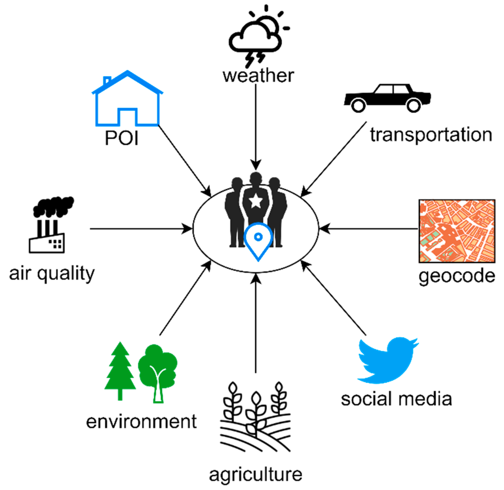
:1. Introduction
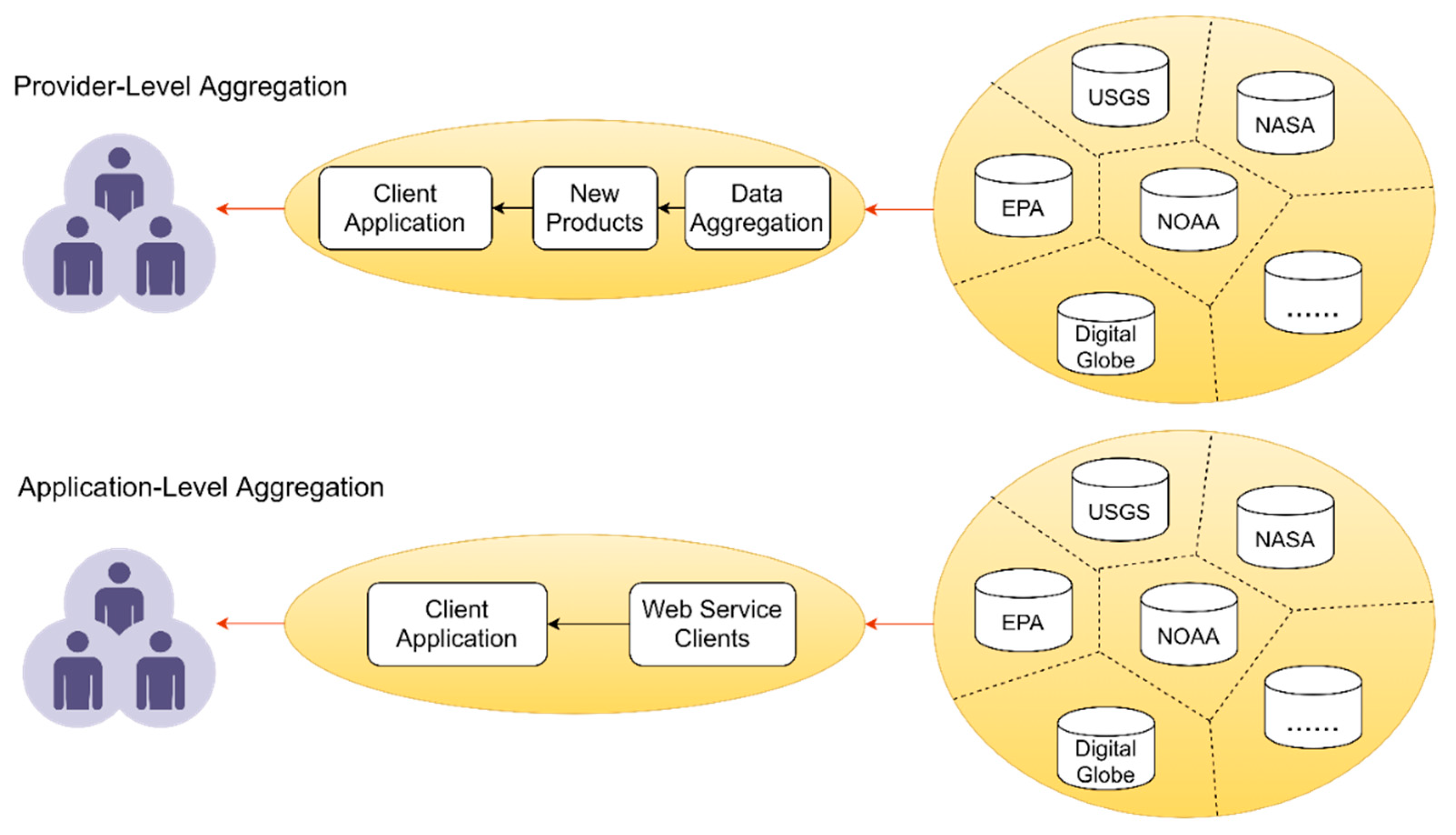
2. Related Work
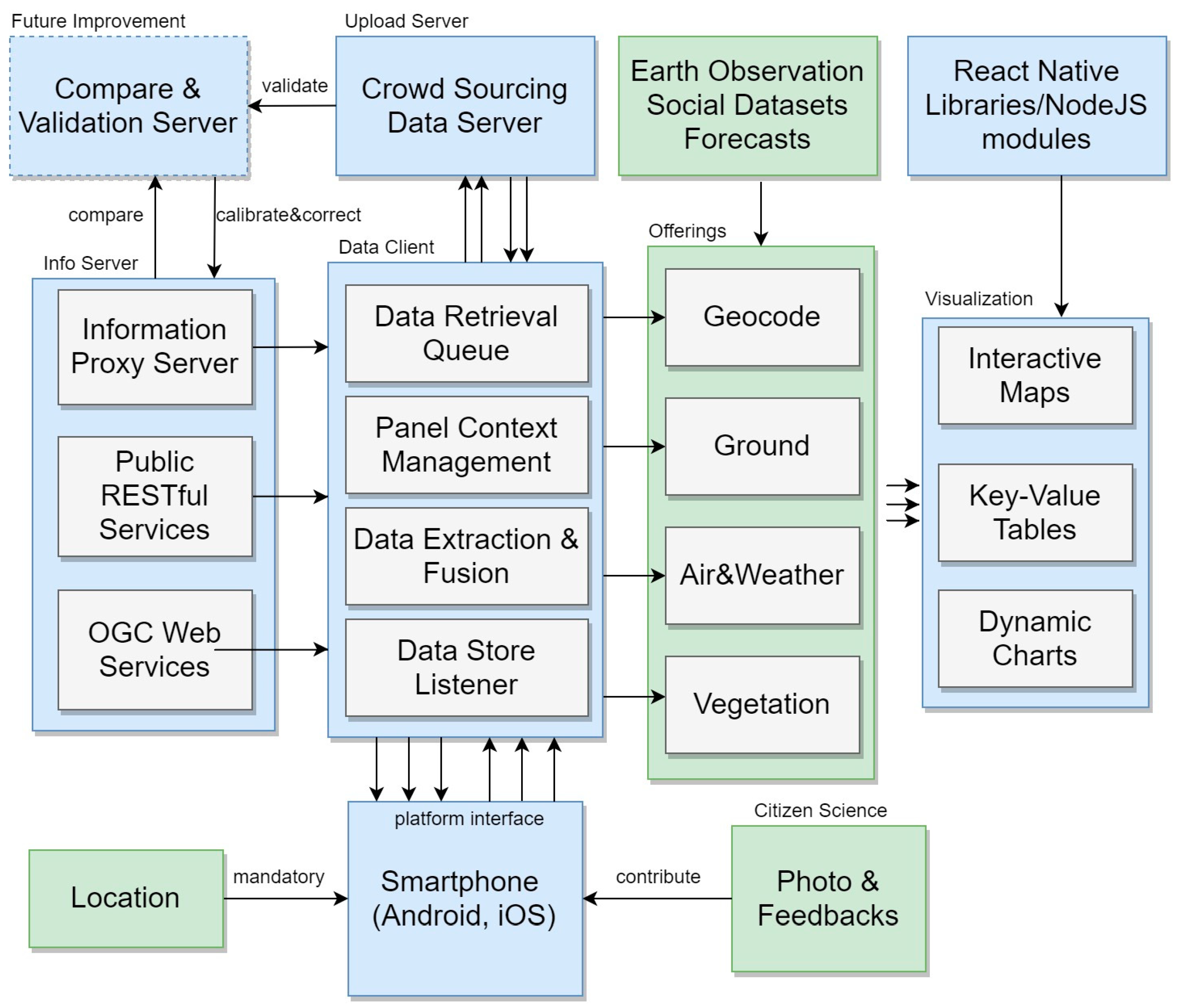
3. Framework
3.1. Geospatial Web Service Module
3.1.1. High Sustainability
3.1.2. High Throughput & Low Latency
3.1.3. Interoperable Interface
3.2. Communication Module
3.3. Mobile Gateway Endpoint Module
3.3.1. Data Retrieval Queue Submodule
3.3.2. Data Extraction & Fusion Submodule
3.3.3. Data Store Listener Submodule
3.3.4. Panel Context Management Submodule
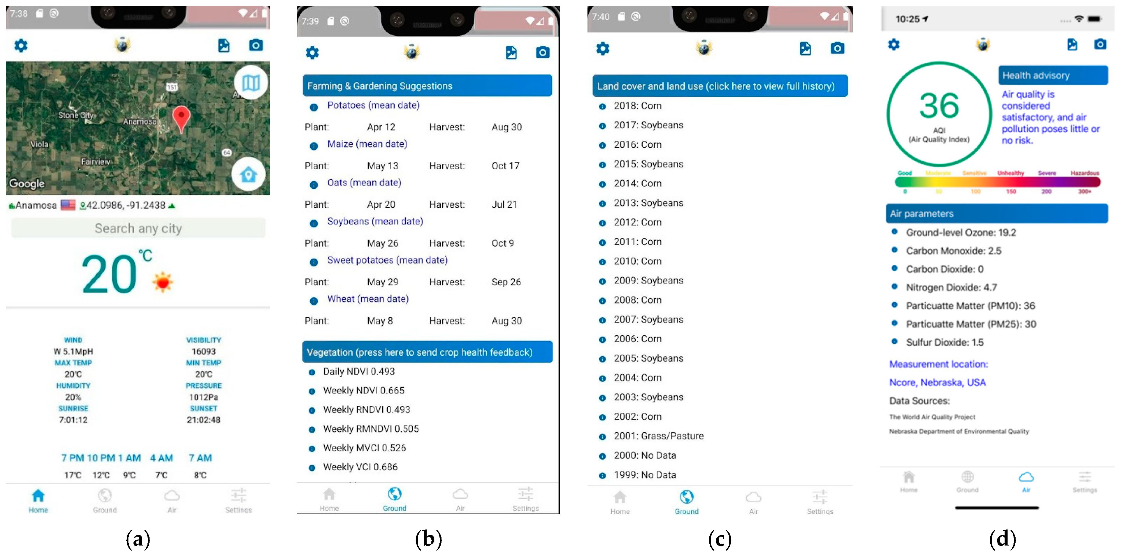
3.3.5. Visualization
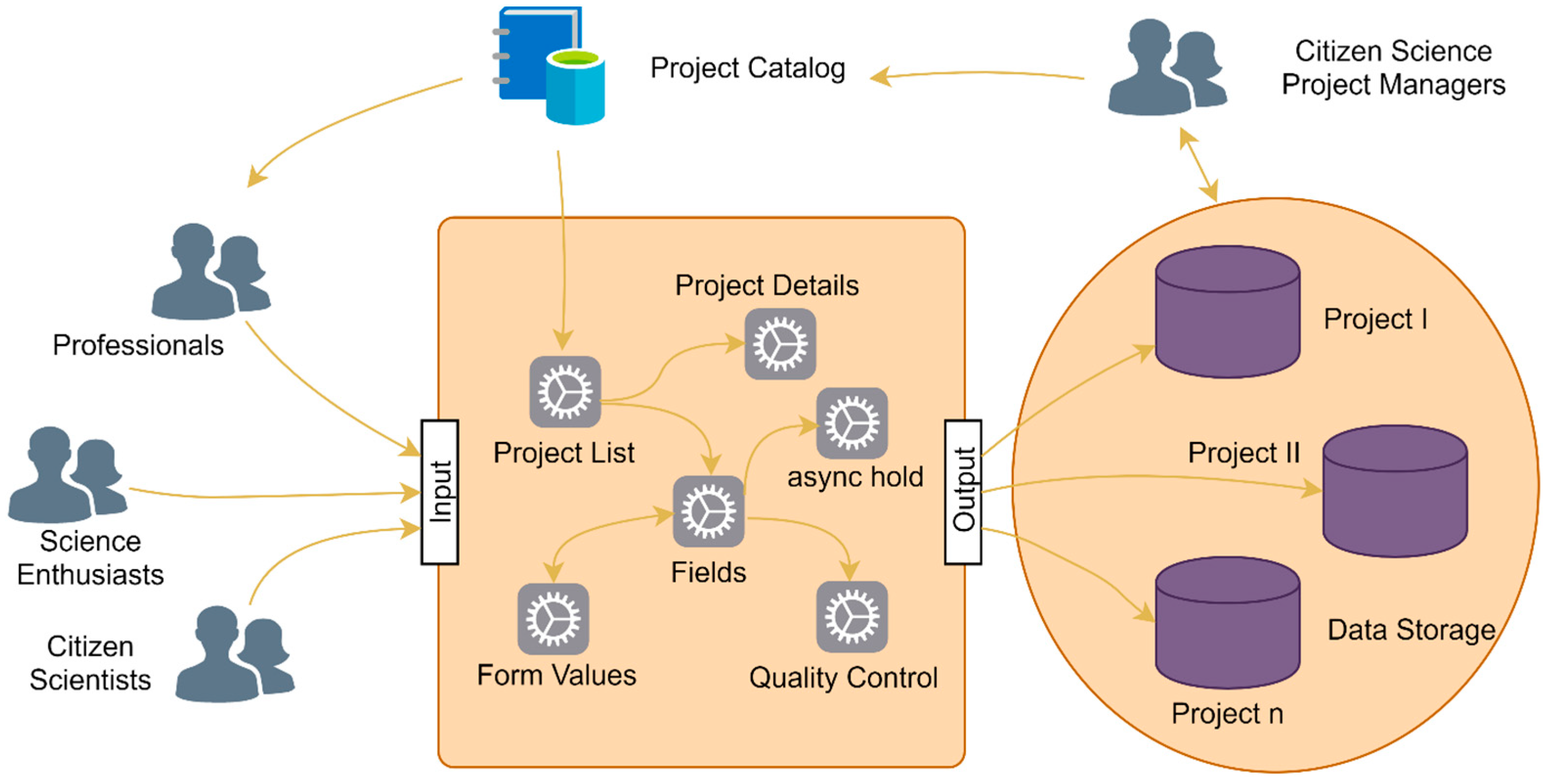
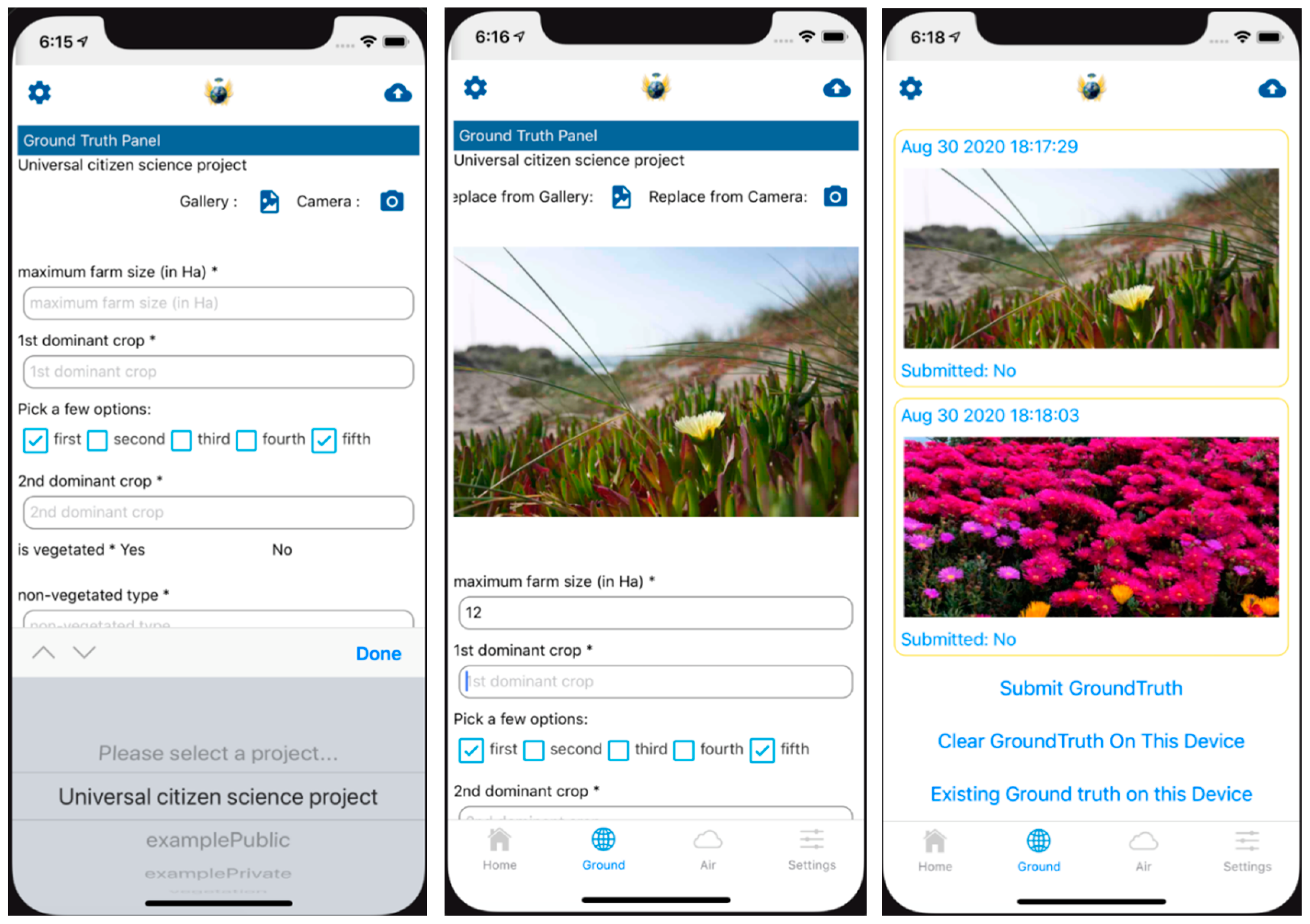
3.4. Citizen Science Module
4. Results
4.1. System Development
4.2. Demonstration
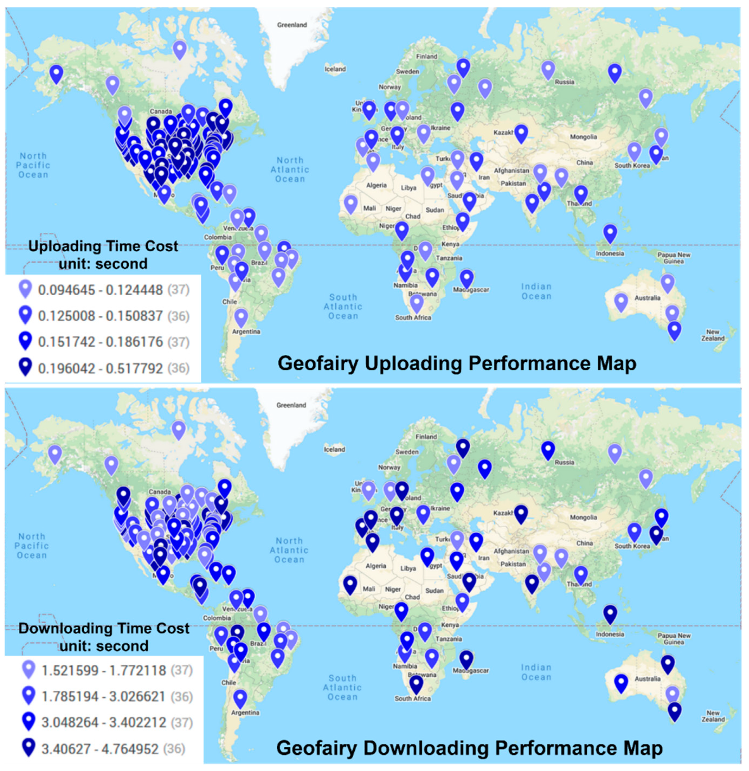
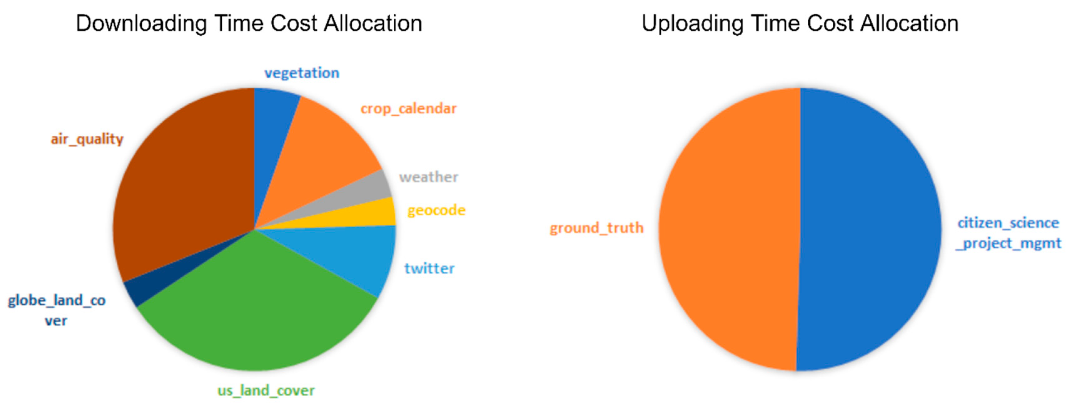
4.3. Testing
5. Discussion
6. Conclusions
Author Contributions
Funding
Conflicts of Interest
References
- Haklay, M.; Weber, P. Openstreetmap: User-generated street maps. Pervasive Comput. IEEE 2008, 7, 12–18. [Google Scholar] [CrossRef] [Green Version]
- Wick, M.; Boutreux, C. GeoNames. Available online: https://www.geonames.org (accessed on 20 December 2020).
- Kyzirakos, K.; Karpathiotakis, M.; Garbis, G.; Nikolaou, C.; Bereta, K.; Papoutsis, I.; Herekakis, T.; Michail, D.; Koubarakis, M.; Kontoes, C. Wildfire monitoring using satellite images, ontologies and linked geospatial data. J. Web Semant. 2014, 24, 18–26. [Google Scholar] [CrossRef] [Green Version]
- Bai, Y.; Di, L.; Wei, Y. A taxonomy of geospatial services for global service discovery and interoperability. Comput. Geosci. 2009, 35, 783–790. [Google Scholar] [CrossRef]
- Tsou, M.-H. Integrated mobile GIS and wireless internet map servers for environmental monitoring and management. Cartogr. Geogr. Inf. Sci. 2004, 31, 153–165. [Google Scholar] [CrossRef] [Green Version]
- Komar, C.; Ersoy, C. Location tracking and location based service using IEEE 802.11 WLAN infrastructure. In Proceedings of the European Wireless Workshop, Barcelona, Spain, 24–27 February 2004; pp. 24–27. [Google Scholar]
- Council, N.R. Putting People on the Map: Protecting Confidentiality with Linked Social-Spatial Data; National Academies Press: Washington DC, USA, 2007. [Google Scholar]
- Sun, Z.; Di, L.; Heo, G.; Zhang, C.; Fang, H.; Yue, P.; Jiang, L.; Tan, X.; Guo, L.; Lin, L. GeoFairy: Towards a one-stop and location based Service for Geospatial Information Retrieval. Comput. Environ. Urban Syst. 2017, 62, 156–167. [Google Scholar] [CrossRef] [Green Version]
- Dehnen-Schmutz, K.; Foster, G.L.; Owen, L.; Persello, S. Exploring the role of smartphone technology for citizen science in agriculture. Agron. Sustain. Dev. 2016, 36, 1–8. [Google Scholar] [CrossRef] [Green Version]
- Hitzler, P.; Janowicz, K. Linked Data, Big Data, and the 4th Paradigm. Semant. Web 2013, 4, 233–235. [Google Scholar] [CrossRef] [Green Version]
- Roth, M.; Bröring, A. Linked open data in spatial data infrastructures. Available online: https://wiki.52north.org/pub/Projects/GLUES/2012-09-10_LoD_SDI_White_Paper_MR_AB.pdf (accessed on 20 December 2020).
- Janowicz, K.; Scheider, S.; Pehle, T.; Hart, G. Geospatial semantics and linked spatiotemporal data—Past, present, and future. Semant. Web 2012, 3, 321–332. [Google Scholar] [CrossRef] [Green Version]
- Yue, P.; Guo, X.; Zhang, M.; Jiang, L.; Zhai, X. Linked Data and SDI: The case on Web geoprocessing workflows. ISPRS J. Photogramm. Remote Sens. 2016, 114, 245–257. [Google Scholar] [CrossRef]
- Becker, C.; Bizer, C. Exploring the Geospatial Semantic Web with DBpedia Mobile. Web Semant. Sci. Serv. Agents World Wide Web 2009, 7, 278–286. [Google Scholar] [CrossRef]
- Stadler, C.; Lehmann, J.; Höffner, K.; Auer, S. Linkedgeodata: A core for a web of spatial open data. Semant. Web 2012, 3, 333–354. [Google Scholar] [CrossRef]
- Bakillah, M.; Mostafavi, M.A.; Liang, S.H. Enriching SQWRL queries in support of geospatial data retrieval from multiple and complementary sources. In Proceedings of the International Conference on Conceptual Modeling, Florence, Italy, 15 October 2012; pp. 241–250. [Google Scholar]
- Bizer, C.; Heath, T.; Berners-Lee, T. Linked data: The story so far. In Semantic Services, Interoperability and Web Applications: Emerging Concepts; IGI Global: Hershey, PA, USA, 2011; pp. 205–227. [Google Scholar]
- Tulloch, A.I.; Possingham, H.P.; Joseph, L.N.; Szabo, J.; Martin, T.G. Realising the full potential of citizen science monitoring programs. Biol. Conserv. 2013, 165, 128–138. [Google Scholar] [CrossRef] [Green Version]
- Statista. Number of Smartphone Users Worldwide from 2016 to 2021. Available online: https://0-www-statista-com.brum.beds.ac.uk/statistics/330695/number-of-smartphone-users-worldwide (accessed on 13 December 2020).
- Sousa, L.B.; Fricker, S.R.; Doherty, S.S.; Webb, C.E.; Baldock, K.L.; Williams, C.R. Citizen science and smartphone e-entomology enables low-cost upscaling of mosquito surveillance. Sci. Total Environ. 2020, 704, 135349. [Google Scholar] [CrossRef] [PubMed]
- Michels, M.; Fecke, W.; Feil, J.-H.; Musshoff, O.; Pigisch, J.; Krone, S. Smartphone adoption and use in agriculture: Empirical evidence from Germany. Precis. Agric. 2020, 21, 403–425. [Google Scholar] [CrossRef]
- Uyeda, K.A.; Stow, D.A.; Richart, C.H. Assessment of volunteered geographic information for vegetation mapping. Environ. Monit. Assess. 2020, 192, 1–14. [Google Scholar] [CrossRef] [PubMed]
- Wang, C.; Gimona, A.; Jiang, Y. Geovisualization of Forest Dynamics via Mobile GIS. In Proceedings of the 21st EGU General Assembly (EGU 2019), Vienna, Austria, 7–12 April 2019. [Google Scholar]
- Connors, J.P.; Lei, S.; Kelly, M. Citizen science in the age of neogeography: Utilizing volunteered geographic information for environmental monitoring. Ann. Assoc. Am. Geogr. 2012, 102, 1267–1289. [Google Scholar] [CrossRef]
- Frommberger, L.; Schmid, F.; Cai, C. Micro-mapping with smartphones for monitoring agricultural development. In Proceedings of the 3rd ACM Symposium on Computing for Development, Bangalore, India, 11–12 January 2013; p. 46. [Google Scholar]
- Pongnumkul, S.; Chaovalit, P.; Surasvadi, N. Applications of smartphone-based sensors in agriculture: A systematic review of research. J. Sens. 2015, 2015. [Google Scholar] [CrossRef] [Green Version]
- Lamprou, I. Farmuino. Available online: https://play.google.com/store/apps/details?id=com.javapapers.android.agrofarmlitetrial (accessed on 12 August 2020).
- AgriApp. AgriApp: Smart Farming App for Indian Agriculture. Available online: https://play.google.com/store/apps/details?id=com.criyagen (accessed on 13 December 2020).
- Farmis. Agrobase—Weed, Disease, Insect. Available online: https://play.google.com/store/apps/details?id=lt.farmis.apps.farmiscatalog (accessed on 13 December 2020).
- IQAir. AirVisual. Available online: https://play.google.com/store/apps/details?id=com.airvisual (accessed on 12 August 2020).
- EPA. EPA’s AIRNow. Available online: https://play.google.com/store/apps/details?id=com.saic.airnow (accessed on 12 August 2020).
- Sun, Z.; Yue, P. The use of Web 2.0 and geoprocessing services to support geoscientific workflows. In Proceedings of the 2010 18th International Conference on Geoinformatics, Beijing, China, 18–20 June 2010; pp. 1–5. [Google Scholar]
- Gaigalas, J.; Di, L.; Sun, Z. Advanced Cyberinfrastructure to Enable Search of Big Climate Datasets in THREDDS. ISPRS Int. J. Geo-Inf. 2019, 8, 494. [Google Scholar] [CrossRef] [Green Version]
- Sun, Z.; Di, L.; Zhang, C.; Fang, H.; Yu, E.; Lin, L.; Tang, J.; Tan, X.; Liu, Z.; Jiang, L. Building robust geospatial web services for agricultural information extraction and sharing. In Proceedings of the 2017 6th International Conference on Agro-Geoinformatics (Agro-Geoinformatics), Fairfax, VA, USA, 7–10 August 2017; pp. 1–4. [Google Scholar]
- Sun, Z.; Di, L.; Zhang, C.; Lin, L.; Fang, H.; Tan, X.; Yue, P. Combining OGC WCS with SOAP to faciliate the retrieval of remote sensing imagery about agricultural fields. In Proceedings of the 2016 5th International Conference on Agro-Geoinformatics (Agro-Geoinformatics), Tianjin, China, 18–20 July 2016; pp. 1–4. [Google Scholar]
- Tan, X.; Guo, S.; Di, L.; Deng, M.; Huang, F.; Ye, X.; Sun, Z.; Gong, W.; Sha, Z.; Pan, S. Parallel Agent-as-a-Service (P-AaaS) Based Geospatial Service in the Cloud. Remote Sens. 2017, 9, 382. [Google Scholar] [CrossRef] [Green Version]
- Yue, P.; Gong, J.; Di, L.; Yuan, J.; Sun, L.; Sun, Z.; Wang, Q. GeoPW: Laying Blocks for the Geospatial Processing Web. Trans. GIS 2010, 14, 755–772. [Google Scholar] [CrossRef]
- Gao, S.; Mioc, D.; Yi, X. The measurement of geospatial Web service quality in SDIs. In Proceedings of the 2009 17th International Conference on Geoinformatics, Fairfax, VA, USA, 12–14 August 2009; pp. 1–6. [Google Scholar]
- Killelea, P. Web Performance Tuning: Speeding Up the Web; O’Reilly Media Inc.: Sebastopol, CA, USA, 2002. [Google Scholar]
- Sun, Z.; Di, L.; Huang, H.; Wu, X.; Tong, D.Q.; Zhang, C.; Virgei, C.; Fang, H.; Yu, E.; Tan, X. CyberConnector: A service-oriented system for automatically tailoring multisource Earth observation data to feed Earth science models. Earth Sci. Inform. 2017, 11, 1–17. [Google Scholar] [CrossRef]
- OGC. Web Map Service. Version: 2006. Available online: portal.opengeospatial.org/files/?artifact_id=14416 (accessed on 20 December 2020).
- Initiative, O. OpenAPI Specification 3.0.3. Available online: https://github.com/OAI/OpenAPI-Specification/blob/master/versions/3.0.3.md (accessed on 13 December 2020).
- Rodrigues, C.; Afonso, J.; Tomé, P. Mobile application webservice performance analysis: Restful services with json and xml. In Proceedings of the International Conference on ENTERprise Information Systems, Vilamoura, Portugal, 5–7 October 2011; pp. 162–169. [Google Scholar]
- Fette, I.; Melnikov, A. The websocket protocol. RFC 6455, December: 2011. Available online: https://tools.ietf.org/html/rfc6455 (accessed on 20 December 2020).
- Homer, C.; Dewitz, J.; Yang, L.; Jin, S.; Danielson, P.; Xian, G.; Coulston, J.; Herold, N.; Wickham, J.; Megown, K. Completion of the 2011 National Land Cover Database for the conterminous United States—Representing a decade of land cover change information. Photogramm. Eng. Remote Sens. 2015, 81, 345–354. [Google Scholar]
- NASA. MODIS Data Products Table. Available online: https://lpdaac.usgs.gov/dataset_discovery/modis/modis_products_table (accessed on 1 December 2015).
- Boryan, C.; Yang, Z.; Mueller, R.; Craig, M. Monitoring US agriculture: The US department of agriculture, national agricultural statistics service, cropland data layer program. Geocarto Int. 2011, 26, 341–358. [Google Scholar] [CrossRef]
- Sun, Z.; Di, L.; Burgess, A.; Tullis, J.A.; Magill, A.B. Geoweaver: Advanced Cyberinfrastructure for Managing Hybrid Geoscientific AI Workflows. ISPRS Int. J. Geo-Inf. 2020, 9, 119. [Google Scholar] [CrossRef] [Green Version]
- Sun, Z.; Di, L.; Cash, B.; Gaigalas, J. Advanced cyberinfrastructure for intercomparison and validation of climate models. Environ. Model. Softw. 2019, 104559. [Google Scholar] [CrossRef]
- Kluyver, T.; Ragan-Kelley, B.; Pérez, F.; Granger, B.E.; Bussonnier, M.; Frederic, J.; Kelley, K.; Hamrick, J.B.; Grout, J.; Corlay, S.; et al. Jupyter Notebooks—A publishing format for reproducible computational workflows. In Proceedings of the ELPUB, Göttingen, Germany, 7–9 June 2016; pp. 87–90. [Google Scholar]
- Cvetojevic, S.; Sun, Z. Geofairy. Available online: https://play.google.com/store/apps/details?id=edu.gmu.csiss.geofairy (accessed on 12 August 2020).
- Sun, Z. Geofairy2. Available online: https://apps.apple.com/us/app/GeoFairy2/id1511068881 (accessed on 12 August 2020).
- NOAA. National Weather Service—Service API. Available online: https://www.weather.gov/documentation/services-web-api (accessed on 13 December 2020).
- OpenWeather. Open Weather Map. Available online: https://openweathermap.org/ (accessed on 13 December 2020).
- Makice, K. Twitter API: Up and Running: Learn How to Build Applications with the Twitter API; O’Reilly Media Inc.: Sebastopol, CA, USA, 2009. [Google Scholar]
- Team, W.A.Q.I. World Air Quality Index Project. Available online: https://waqi.info (accessed on 13 December 2020).
- NASA. NASA GSFS Web Map Service. Available online: https://neo.sci.gsfc.nasa.gov/about/wms.php (accessed on 13 December 2020).
- Mayaux, P.; Eva, H.; Gallego, J.; Strahler, A.H.; Herold, M.; Agrawal, S.; Naumov, S.; De Miranda, E.E.; Di Bella, C.M.; Ordoyne, C. Validation of the global land cover 2000 map. IEEE Trans. Geosci. Remote Sens. 2006, 44, 1728–1739. [Google Scholar] [CrossRef] [Green Version]
- Daly, C.; Widrlechner, M.P.; Halbleib, M.D.; Smith, J.I.; Gibson, W.P. Development of a new USDA plant hardiness zone map for the United States. J. Appl. Meteorol. Climatol. 2012, 51, 242–264. [Google Scholar] [CrossRef] [Green Version]
- Sacks, W.J.; Deryng, D.; Foley, J.A.; Ramankutty, N. Crop planting dates: An analysis of global patterns. Glob. Ecol. Biogeogr. 2010, 19, 607–620. [Google Scholar] [CrossRef]
- Mueller, R. VegScape: A NASS Web Service-based US Crop Condition Monitoring System. In Proceedings of the USDA’s 2013 Agricultural Outlook Forum, Arlington, Virginia, 21–22 February 2013. [Google Scholar]
- Sun, Z.; Peng, C.; Deng, M.; Chen, A.; Yue, P.; Fang, H.; Di, L. Automation of Customized and Near-Real-Time Vegetation Condition Index Generation Through Cyberinfrastructure-Based Geoprocessing Workflows. IEEE J. Sel. Top. Appl. Earth Obs. Remote Sens. 2014, 7, 4512–4522. [Google Scholar] [CrossRef]
- Zhong, S.; Xu, Z.; Sun, Z.; Yu, E.; Guo, L.; Di, L. Global vegetative drought trend and variability analysis from long-term remotely sensed data. In Proceedings of the 2019 8th International Conference on Agro-Geoinformatics (Agro-Geoinformatics), Istanbul, Turkey, 16–19 July 2019; pp. 1–6. [Google Scholar]
- Sun, Z.; Di, L.; Fang, H.; Guo, L.; Yu, E.; Tang, J.; Zhao, H.; Gaigalas, J.; Zhang, C.; Lin, L. Advanced Cyberinfrastructure for Agricultural Drought Monitoring. In Proceedings of the 2019 8th International Conference on Agro-Geoinformatics (Agro-Geoinformatics), Istanbul, Turkey, 16–19 July 2019; pp. 1–5. [Google Scholar]
- Karnieli, A.; Bayasgalan, M.; Bayarjargal, Y.; Agam, N.; Khudulmur, S.; Tucker, C. Comments on the use of the vegetation health index over Mongolia. Int. J. Remote Sens. 2006, 27, 2017–2024. [Google Scholar] [CrossRef]
- Chen, B.; Xu, B.; Zhu, Z.; Yuan, C.; Suen, H.P.; Guo, J.; Xu, N.; Li, W.; Zhao, Y.; Yang, J. Stable classification with limited sample: Transferring a 30 m resolution sample set collected in 2015 to mapping 10 m resolution global land cover in 2017. Sci. Bull. 2019, 64, 370–373. [Google Scholar]
- Han, W.; Yang, Z.; Di, L.; Mueller, R. CropScape: A Web service based application for exploring and disseminating US conterminous geospatial cropland data products for decision support. Comput. Electron. Agric. 2012, 84, 111–123. [Google Scholar] [CrossRef]
- Sun, Z.; Di, L.; Fang, H.; Burgess, A. Deep Learning Classification for Crop Types in North Dakota. IEEE J. Sel. Top. Appl. Earth Obs. Remote Sens. 2020, 13, 2200–2213. [Google Scholar] [CrossRef]
- Sun, Z.; Fang, H.; Di, L.; Yue, P. Realizing parameterless automatic classification of remote sensing imagery using ontology engineering and cyberinfrastructure techniques. Comput. Geosci. 2016, 94, 56–67. [Google Scholar] [CrossRef] [Green Version]
- Sun, Z.; Di, L.; Fang, H. Using long short-term memory recurrent neural network in land cover classification on Landsat and Cropland data layer time series. Int. J. Remote Sens. 2018, 40, 593–614. [Google Scholar] [CrossRef]
- CSRL. Soil Properties Web Application. Available online: https://casoilresource.lawr.ucdavis.edu/soil-properties (accessed on 13 December 2020).
- Müller, R.D.; Cannon, J.; Qin, X.; Watson, R.J.; Gurnis, M.; Williams, S.; Pfaffelmoser, T.; Seton, M.; Russell, S.H.; Zahirovic, S. GPlates: Building a virtual Earth through deep time. Geochem. Geophys. Geosystems 2018, 19, 2243–2261. [Google Scholar] [CrossRef]
- Sun, Z.; Di, L.; Sprigg, W.; Tong, D.; Casal, M. Community venue exposure risk estimator for the COVID-19 pandemic. Health Place 2020, 66, 102450. [Google Scholar] [CrossRef]


| Dataset Name | Web Service Provider | Interoperability Protocol |
|---|---|---|
| Satellite Imagery Layer | Google & Apple | Google Tile/Apple Tile API |
| Street Map Layer | Google & Apple | Google Tile/Apple Tile API |
| Weather & Forecasting | NOAA [53] & OpenWeather [54] | NWS API/Weather API |
| Cropland Data Layer | GMU | WMS |
| Crop Calendar Layer | GMU | WMS |
| Twitter Feeds | Twitter API [55] | |
| Vegetation Status | GMU & NASA | WMS |
| Air Quality | World Air Quality Index [56] | WAQI API |
| Geocoding | Google API | |
| Elevation | USGS | WMS |
| Atmosphere | NASA [57] | WMS |
| Global Land Cover 2000 | JRC-IES [58] | WMS |
| Agricultural Hardiness | USDA [59] | GIS REST API |
Publisher’s Note: MDPI stays neutral with regard to jurisdictional claims in published maps and institutional affiliations. |
© 2020 by the authors. Licensee MDPI, Basel, Switzerland. This article is an open access article distributed under the terms and conditions of the Creative Commons Attribution (CC BY) license (http://creativecommons.org/licenses/by/4.0/).
Share and Cite
Sun, Z.; Di, L.; Cvetojevic, S.; Yu, Z. GeoFairy2: A Cross-Institution Mobile Gateway to Location-Linked Data for In-Situ Decision Making. ISPRS Int. J. Geo-Inf. 2021, 10, 1. https://0-doi-org.brum.beds.ac.uk/10.3390/ijgi10010001
Sun Z, Di L, Cvetojevic S, Yu Z. GeoFairy2: A Cross-Institution Mobile Gateway to Location-Linked Data for In-Situ Decision Making. ISPRS International Journal of Geo-Information. 2021; 10(1):1. https://0-doi-org.brum.beds.ac.uk/10.3390/ijgi10010001
Chicago/Turabian StyleSun, Ziheng, Liping Di, Sreten Cvetojevic, and Zhiqi Yu. 2021. "GeoFairy2: A Cross-Institution Mobile Gateway to Location-Linked Data for In-Situ Decision Making" ISPRS International Journal of Geo-Information 10, no. 1: 1. https://0-doi-org.brum.beds.ac.uk/10.3390/ijgi10010001