From Manual to Intelligent: A Review of Input Data Preparation Methods for Geographic Modeling

 , , , , and
Abstract
:
1. Introduction
2. Factors Influencing Input Data Preparation
- Diverse application contexts of a geographic model. In real applications, a geographic model might be used with diverse application contexts, which include the application purpose (or objective), data availability, spatial and temporal scale, and study area characteristics such as climate, topography, and soil [1,34,39,40,41]. A specific geographic model in different application contexts might need different data pre-processing workflows to meet its input data requirements [41,42,43]. For example, the optimal spatial resolution of SWAT (Soil and Water Assessment Tool) [44] modeling in a large mountainous watershed changes with the application purpose (e.g., simulation of flow, sediment, or dissolved oxygen) [45]. Thus, resampling or down-scaling for the input data sources with different resolutions thereby might need to be added into the input data preparation workflow. Moreover, among study areas with different characteristics (e.g., high or low relief), the same pre-processing step in the input data preparation workflow might adopt different algorithms. Another example is that, due to data unavailability (e.g., meteorological observations) in data-scarce regions, hydrological models might use satellite data products and corresponding data pre-processing functionalities [10].
- Diverse characteristics of input data. Generally, geographic models require different types of input data, such as DEM, land cover, soil, and many others. These data are increasingly being obtained from geographically distributed data catalogs or geoportals that are established by cross-domain organizations and are heterogeneous in many aspects such as accessing method, metadata, data format, projection, and resolution [6,46,47,48]. Data quality and spatial/temporal scale are also key issues in geospatial data which have strong influences on the performance of geographic models [49,50,51]. Thus, to obtain sufficient, suitable, and ready-to-use input data for a geographic model, a set of appropriate functionalities (e.g., reformatting, reprojection, etc.) are needed to process the data to the forms required by the geographic model [6]. Therefore, modelers have to devote significant time and effort to familiarize themselves with the characteristics of the collected data.
- Diversity of data pre-processing tools. A single tool is normally not suitable for all data processing tasks (e.g., clipping, reformatting, and reprojection) for a complex geographic model. Thus, modelers have to employ diverse tools (such as ArcGIS and Matlab) to manually or automatically pre-process the obtained data into ready-to-use forms for a model [5,52,53,54]. Normally, these tools developed by different organizations adopt different algorithms, run-time environments, application contexts, and input/output data types. For instance, a topographic attribute can be calculated from several algorithms (such as single- and multiple-flow direction algorithms for flow accumulation calculation). Each algorithm is proposed for specific data types (e.g., grid DEM), terrain conditions (e.g., high or low relief), spatial resolutions (e.g., coarse or fine), or application tasks (e.g., drainage network extraction or topographic wetness index calculation) [50,55,56,57]. Moreover, different algorithms might be implemented in different software and require different pre-processing steps (e.g., pit removing of DEM-preprocessing for flow direction algorithms). Consequently, finding and using appropriate data pre-processing tools to prepare input data for geographic models require considerable expertise and experience. Training time is long and the learning curve is steep for users who want to acquire such expertise and experience.
3. Key Tasks in Developing Input Data Preparation Methods for Geographic Models
- Integration of input data preparation tools for geographic models. Currently, except for a few widely used models like SWAT, most geographic models lack a tool to assist modelers to easily and efficiently prepare input data. Coupling related tools to an integrated data pre-processing environment provide a reasonable strategy to solve this problem. On the one hand, these environments reduce the number of tools used, thus reducing software setup and training time. On the other hand, applying widely used standards and specifications could improve the interoperability of coupled tools, which could facilitate data exchange among tools and avoid breaking the data pre-processing workflow [1,6,38,58].
- Developing automatic input data preparation methods for geographic models. A common task in input data preparation for geographic models is repetitive data pre-processing workflows, such as watershed delineation and topographic wetness index (TWI) calculation, which chain a sequence of data processing tools to produce the desired outputs. Automating these sophisticated data pre-processing workflows in geographic modeling environments could allow modelers to concentrate on solving key problems instead of trivial technical details [6,38], and could also improve the reproducibility of existing studies [13,59].
- Developing intelligent methods to support the automatic preparation of input data for geographic models in an application-context-adaptive way. As noted above, the application context of a geographic model strongly influences the selection of both preliminary input data (including data contents and characteristics, e.g., spatial resolution) and corresponding data pre-processing tools/algorithms (including parameter-settings). This requires extensive geographic modeling knowledge, which poses a challenge for modelers, especially for novices. Knowledge-driven intelligent input data preparation methods could overcome the problem and improve efficiency. These methods explicitly and meaningfully formalize and interlink geographic modeling knowledge, thereby reducing the semantic heterogeneity and improving the interoperability of modeling resources, including models, data, algorithms, and algorithm implementations such as software tools and web services. Both explicit and implicit relationships could be inferred through reasoning and semantic similarity calculation. As a consequence, intelligent input data preparation methods could not only automate the discovery and integration of data, models, and data pre-processing workflows, but also ensure the prepared input data match the application context [33,34,37,60].
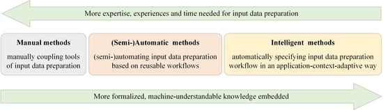
4. Classification of Existing Input Data Preparation Methods for Geographic Models
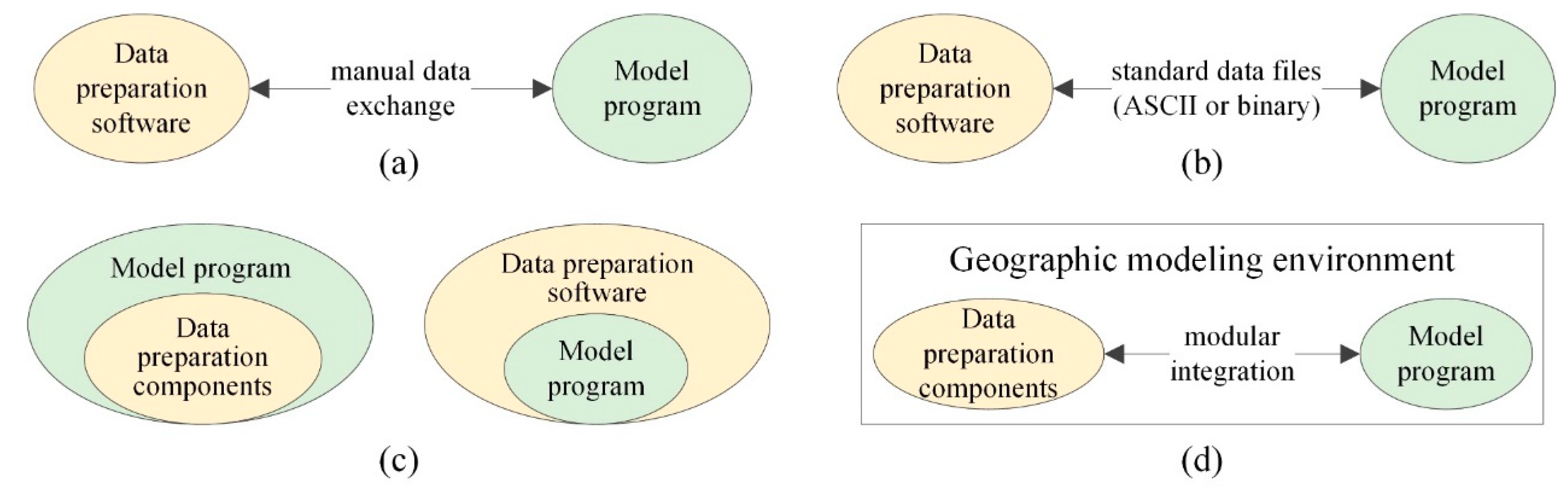
4.1. Manual Methods
4.2. (Semi-)Automatic Methods
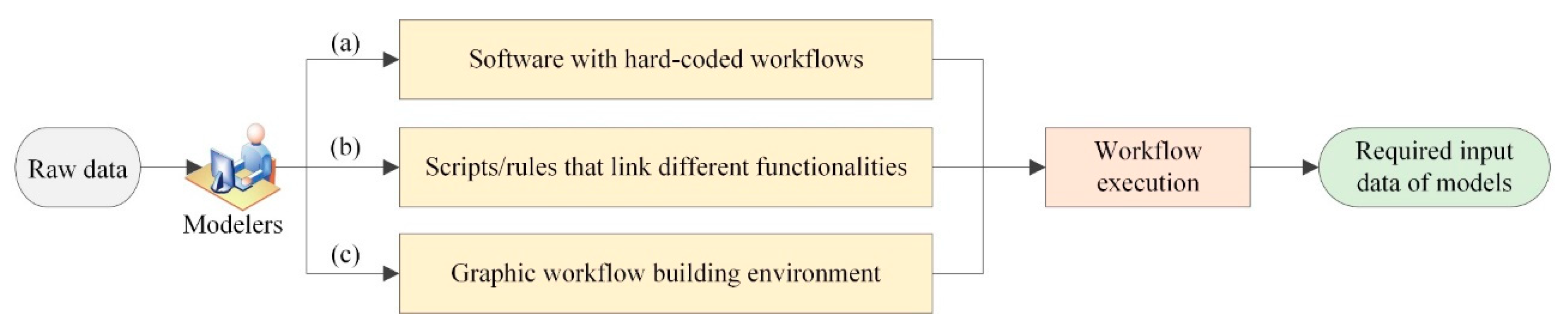
- Automatic input data preparation based on hard-coded workflows (Figure 3(a)). This category of methods embeds stable data processing workflows into data preparation tools via programming, such as the watershed delineation workflows hard-coded in ArcSWAT [76] and HydroTerre [77]. This way avoids wasteful repetitive efforts and smooths the learning curve for novices, but it is costly and difficult to develop these automatic methods. Moreover, automatic methods based on hard-coded workflows are “black-boxes”, meaning modelers can neither directly understand how these methods work nor adjust them for specific application contexts.
- Script-based (semi-)automatic input data preparation (Figure 3(b)). Workflows used to create input data for geographic models can be complicated and require multiple data processing functionalities from different tools (e.g., MATLAB, ArcGIS, and Python packages). This category of methods uses editable scripts (including rule files that control the execution order) to link the required functionality to (semi-)automatic data preparation workflows [29,38,59,78,79,80]. This way is more flexible and extensible than the hard-code methods. As such, modelers can modify or add new scripts to customize the workflows according to the application contexts. However, this category of (semi-)automatic methods requires extensive user technical expertise and modeling experience.
- Graphic workflow building environment for input data preparation (Figure 3(c)). This method involves the use of graphic modeling panel to assist users to visually and quickly build or reuse, revise, and configure workflows. The generated workflows can then be executed to prepare input data automatically. In recent years, service-oriented graphic workflow building environments, such as Giovanni [81], GeoJModelBuilder [82], and CyberConnector [6,73], have attracted attention. Web services facilitate the sharing, reuse, and coupling of data processing functionalities, workflows, and computing resources. Therefore, this method not only lowers the barriers to build workflows for input data preparation, but also promotes the collaboration of modelers from different disciplines [21,37,83]. However, manually building these input data preparation workflows for novice users is still difficult and laborious. In addition, this category of automatic methods cannot ensure that the generated workflows and configured parameters match the application contexts.
4.3. Intelligent Methods
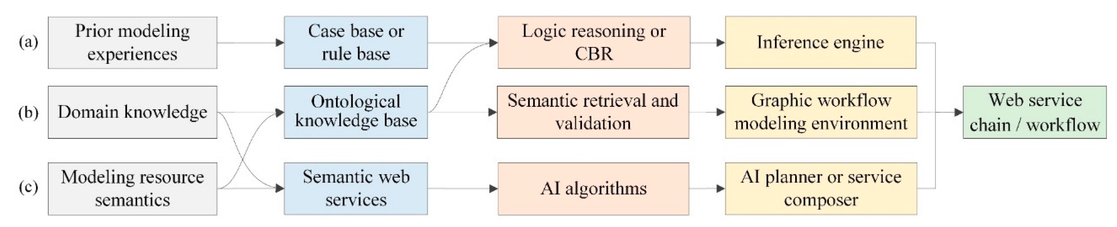
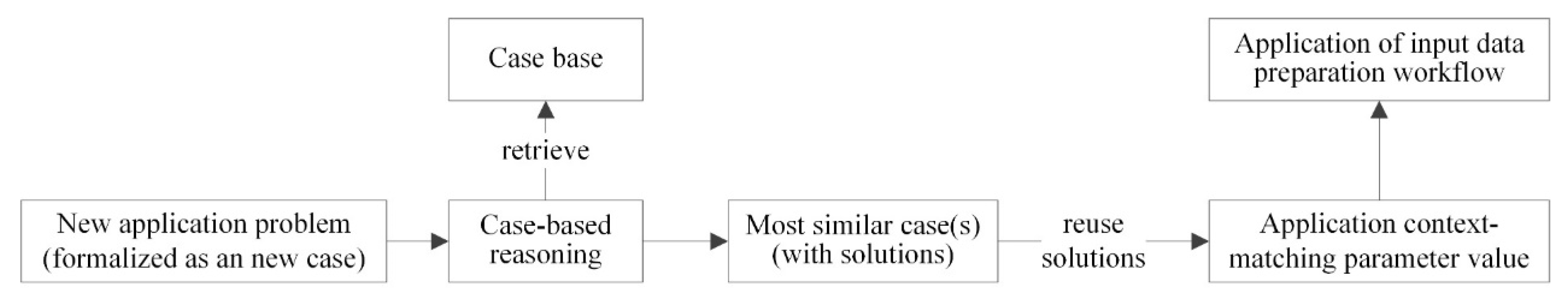
- Knowledge-supported interactive workflow building (Figure 4a). This type of intelligent building method of the input data preparation workflow requires users to manually build data processing workflows in a graphic workflow building environment with the support of a knowledge base and reasoning. For this type of method, modeling resources are semantically enriched, inter-linked, and published as ontologies and/or linked data [35,86,87,88,89], which is different from the automatic methods based on graphic workflow building environments mentioned in Section 4.2. Workflow building knowledge (including tacit experience in existing application cases, relationships between tasks and data, algorithms, and reusable workflows) can also be formalized as CBR cases or ontologies [39,90]. Through querying and reasoning this formalized knowledge, the modeling environment adopting this type of method can assist users in discovering and composing appropriate functionalities to build, validate, and correct or optimize input data preparation workflows [33,39,90,91]. The main problem with the knowledge-supported interactive workflow building is the lack of automation during workflow building.
- Knowledge-driven (semi-)automatic workflow building (Figure 4b). This type of intelligent workflow building methods of input data preparation can (semi-)automatically discover and compose the needed data processing algorithms (or web services) based on semantic matching and reasoning. For example, the heuristic modeling proposed by Jiang, et al. [92] adopts RDF, heuristic modeling, and backward chaining approaches to semi-automatically build abstract workflows. The method starts by selecting an algorithm that can generate outputs matching user-specified target data (i.e., input data for the users’ geographic model). Then, for the selected algorithm, users either set its inputs or invoke the system to automatically expand the workflow by adding other algorithms that can generate the required input data. This procedure is repeated until all the input data of the workflow are available. Besides this heuristic modeling proposed by Jiang et al. [92], other researchers have used ontologies, logical reasoning, and forward-chaining or backward-chaining approaches to automatically discover and compose the required services according to users’ requests [32,93,94]. The match between users’ requests and inputs, outputs, preconditions, and effects/postconditions (IOPE) semantics of web services is based on semantic matching and logical reasoning, such as description logic (DL) reasoning, first-order logic (FOL) reasoning, and rule-based reasoning. The major limitation of knowledge-driven (semi-)automatic workflow building methods is that they cannot ensure the semantic correctness and suitability of the workflow in a specific application context because, except for IO or IOPE, many semantics of a service (e.g., functionality, applicable application contexts, and constraints of data types or formats) are ignored when describing or composing web services.
- Automatic web service composition based on AI planning (Figure 4c). This type of intelligent workflow building method for input data preparation views semantic web services (i.e., services that are semantically annotated using ontologies, e.g., Web Ontology Language for Services (OWL-S) [95] and Web Service Modelling Ontology (WSMO) [96]) as actions, and treats service IOPE semantics as states. Then web service composition becomes a planning problem. To solve this planning problem, AI planning algorithms, for instance, the hierarchical task network (HTN), can be used to find a sequence of actions (i.e., a plan) to change the initial state satisfying the pre-defined goal state (i.e., desired input data for geographic models) [97,98,99,100,101,102]. As a result, modelers could use an AI planner together with an ontology inference engine to create plans and translate them to executable service chains for preparing input data for geographic models. The generated web service chains could be optimized based on the quality of service (QoS) using other AI algorithms such as the genetic algorithm and game theory [103,104]. Note that this type of methods faces similar problems as the knowledge-driven (semi-)automatic workflow building methods presented above.
5. Future Research Directions
- Publishing, sharing, and reusing model data and data pre-processing workflows. Data involved in geographic modeling can be classified into four types: Preliminary data, intermediate data (processing results used by subsequent steps), prepared input data, and simulation results. Publishing, sharing, and reusing these data and the corresponding workflows could avoid repetitive work in the data pre-processing steps for preparing input data, thus reducing errors, and supporting collaboration and reproducibility. This has been demonstrated by several hydrological model data sharing platforms [106,107,108,109] and workflow building environments [73,82]. Whereas a unified, semantically rich, and machine-understandable metadata framework to publish model data and workflows is still lacking. Thus, it is difficult to efficiently discover and reuse multi-source, heterogeneous data and workflows. In addition, due to current sharing platforms being isolated from IMEs, a considerable amount of manual work is required to exchange data between these platforms and IMEs. To solve these problems, web service and semantic web technologies could be used to reduce syntactic and semantic heterogeneities between the data of these platforms and IMEs.
- Integrating both data discovery and processing functionalities into IMEs. As mentioned in Section 2, the integration of data processing functionalities and the geographic model program in IMEs have been extensively researched. However, modelers still have to discover and process input data for geographic models separately. This means that the model input data acquired from data discovery tools, or directly from distributed spatial data infrastructures (SDIs), have to be manually transferred to input data pre-processing tools or IMEs. This procedure is tedious and needs the users to have specialized SDI knowledge (such as metadata standards, protocols, and domain terminologies) and data pre-processing functionalities [5,46]. Recently, integrated geospatial analysis platforms, such as HydroDesktop [48], Google Earth Engine (GEE) [110], and the Joint Research Centre Earth Observation Data and Processing Platform (JEODPP) [111], have attracted increasing interest. They enable users to discover, process, analyze, and visualize the needed data in one platform. Unfortunately, the data discovery and process steps in these platforms have not yet been automated and have not been integrated with IMEs, which means that data have to be exchanged manually. Therefore, integrating both data discovery and processing functionalities into IMEs should be researched in the future.
- Developing task-oriented input data preparation methods. Geographic modeling is inherently task-driven work. These tasks of solving geographic problems are highly dependent on the conceptual knowledge of geographic problem-solving and technical expertise in terms of geographic models, data, data pre-processing tools (including parameter-settings), and workflows. Users can easily understand and express tasks instead of specialized domain knowledge, study area characteristics, and technical details of geographic modeling [112,113]. Recent studies have proposed several task-oriented geospatial data retrieval or processing methods [90,112,113,114,115]. However, these methods are still difficult to use in geographic modeling due to the lack of automation driven by specific task knowledge of geographic modeling, especially of input data preparation.
- Constructing large-scale, high-quality knowledge bases for intelligent geographic modeling. The quantity and quality of formalized geographic modeling knowledge determine the level of automation and intelligence of input data preparation methods and corresponding IMEs [33,35,116]. Currently, a large amount of knowledge on geographic modeling in different domains has not yet been formalized, for example, the knowledge of geoprocessing functionalities, and domain concepts and algorithms of digital terrain analysis [34]. Knowledge fusion and refinement are also urgently needed to alleviate problems of incompleteness, incorrectness, redundancy, and heterogeneity in knowledge bases [116,117,118,119,120]. In addition, few studies have been conducted to address the issue of the representation and reasoning of application-context knowledge [34,39]. Therefore, determining how to construct large-scale and high-quality knowledge bases for intelligent modeling is a key problem in future research. To build these knowledge bases, advanced technologies, such as machine learning, natural language processing, and knowledge graph [121], could be explored to extract, represent, and use the cross-domain modeling knowledge.
6. Summary
Author Contributions
Funding
Conflicts of Interest
References
- Laniak, G.F.; Olchin, G.; Goodall, J.; Voinov, A.; Hill, M.; Glynn, P.; Whelan, G.; Geller, G.; Quinn, N.; Blind, M.; et al. Integrated environmental modeling: A vision and roadmap for the future. Environ. Model. Softw. 2013, 39, 3–23. [Google Scholar] [CrossRef]
- Jakeman, A.; Letcher, R.; Norton, J.; Jakeman, A. Ten iterative steps in development and evaluation of environmental models. Environ. Model. Softw. 2006, 21, 602–614. [Google Scholar] [CrossRef] [Green Version]
- Yue, S.; Chen, M.; Wen, Y.; Lu, G. Service-oriented model-encapsulation strategy for sharing and integrating heterogeneous geo-analysis models in an open web environment. ISPRS J. Photogramm. Remote Sens. 2016, 114, 258–273. [Google Scholar] [CrossRef]
- Peng, S.; Piao, S.; Yu, J.; Liu, Y.; Wang, T.; Zhu, G.; Dong, J.; Miao, C. A review of geographical system models. Prog. Geo 2018, 37, 109–120, (In Chinese with English abstract). [Google Scholar]
- Peckham, S.D.; Goodall, J.L. Driving plug-and-play models with data from web services: A demonstration of interoperability between CSDMS and CUAHSI-HIS. Comput. Geosci. 2013, 53, 154–161. [Google Scholar] [CrossRef]
- Di, L.; Sun, Z.; Yu, E.; Song, J.; Tong, D.; Huang, H.; Wu, X.; Domenico, B. Coupling of Earth Science Models and Earth Observations through OGC Interoperability Specifications. In Proceedings of the 2016 IEEE International Geoscience and Remote Sensing Symposium (IGARSS), Beijing, China, 10–15 July 2016; pp. 3602–3605. [Google Scholar]
- Parsons, M.A. Making data useful for modelers to understand complex Earth systems. Earth Sci. Inform. 2011, 4, 197–223. [Google Scholar] [CrossRef]
- Zhu, Y.; Zhu, A.X.; Feng, M.; Song, J.; Zhao, H.; Yang, J.; Zhang, Q.; Sun, K.; Zhang, J.; Yao, L. A similarity-based automatic data recommendation approach for geographic models. Int. J. Geogr. Inf. Sci. 2017, 2, 1–22. [Google Scholar] [CrossRef]
- Tan, M.L.; Ficklin, D.L.; Dixon, B.; Ibrahim, A.L.; Yusop, Z.; Chaplot, V. Impacts of DEM resolution, source, and resampling technique on SWAT-simulated streamflow. Appl. Geogr. 2015, 63, 357–368. [Google Scholar] [CrossRef]
- Cai, M.; Yang, S.; Zhao, C.; Zhou, Q.; Hou, L. Insight into runoff characteristics using hydrological modeling in the data-scarce southern Tibetan Plateau: Past, present, and future. PLoS ONE 2017, 12, 0176813. [Google Scholar] [CrossRef]
- Liu, C.; Bai, P.; Wang, Z.; Liu, S.; Liu, X. Study on prediction of ungaged basins: A case study on the Tibetan Plateau. J. Hydraul. Eng. 2016, 47, 272–282, (In Chinese with English abstract). [Google Scholar]
- Fatichi, S.; Vivoni, E.R.; Ogden, F.L.; Ivanov, V.Y.; Mirus, B.; Gochis, D.; Downer, C.W.; Camporese, M.; Davison, J.H.; Ebel, B.; et al. An overview of current applications, challenges, and future trends in distributed process-based models in hydrology. J. Hydrol. 2016, 537, 45–60. [Google Scholar] [CrossRef] [Green Version]
- Morsy, M.M.; Goodall, J.L.; Castronova, A.M.; Dash, P.; Merwade, V.; Sadler, J.M.; Rajib, M.A.; Horsburgh, J.S.; Tarboton, D.G. Design of a metadata framework for environmental models with an example hydrologic application in HydroShare. Environ. Model. Softw. 2017, 93, 13–28. [Google Scholar] [CrossRef] [Green Version]
- Lü, G.N. Geographic analysis-oriented Virtual Geographic Environment: Framework, structure and functions. Sci. China Earth Sci. 2011, 54, 733–743. [Google Scholar] [CrossRef]
- Horsburgh, J.S.; Reeder, S.L. Data visualization and analysis within a Hydrologic Information System: Integrating with the R statistical computing environment. Environ. Model. Softw. 2014, 52, 51–61. [Google Scholar] [CrossRef]
- Voinov, A.; Jenni, K.; Gray, S.; Kolagani, N.; Glynn, P.D.; Bommel, P.; Prell, C.; Zellner, M.; Paolisso, M.; Jordan, R.; et al. Tools and methods in participatory modeling: Selecting the right tool for the job. Environ. Model. Softw. 2018, 109, 232–255. [Google Scholar] [CrossRef] [Green Version]
- Cheng, G.; Li, X.; Zhao, W.; Xu, Z.; Feng, Q.; Xiao, S.; Xiao, H. Integrated study of the water–ecosystem–economy in the Heihe River Basin. Natl. Sci. Rev. 2014, 1, 413–428. [Google Scholar] [CrossRef]
- Argent, R.M. An overview of model integration for environmental applications—Components, frameworks and semantics. Environ. Model. Softw. 2004, 19, 219–234. [Google Scholar] [CrossRef]
- Granell, C.; Schade, S.; Ostländer, N. Seeing the forest through the trees: A review of integrated environmental modelling tools. Comput. Environ. Urban Syst. 2013, 41, 136–150. [Google Scholar] [CrossRef]
- Goodall, J.; Horsburgh, J.; Whiteaker, T.; Maidment, D.; Zaslavsky, I. A first approach to web services for the National Water Information System. Environ. Model. Softw. 2008, 23, 404–411. [Google Scholar] [CrossRef]
- Hofer, B. Uses of online geoprocessing technology in analyses and case studies: A systematic analysis of literature. Int. J. Digit. Earth 2015, 8, 901–917. [Google Scholar] [CrossRef]
- Nativi, S.; Mazzetti, P.; Geller, G.N. Environmental model access and interoperability: The GEO Model Web initiative. Environ. Model. Softw. 2013, 39, 214–228. [Google Scholar] [CrossRef]
- Yang, C.; Huang, Q.; Li, Z.; Liu, K.; Hu, F. Big Data and cloud computing: Innovation opportunities and challenges. Int. J. Digit. Earth 2017, 10, 13–53. [Google Scholar] [CrossRef]
- Wang, S.; Anselin, L.; Bhaduri, B.; Crosby, C.; Goodchild, M.F.; Liu, Y.Y.; Nyerges, T.L. CyberGIS software: A synthetic review and integration roadmap. Int. J. Geogr. Inf. Sci. 2013, 27, 2122–2145. [Google Scholar] [CrossRef]
- Jiang, J.; Zhu, A.X.; Qin, C.; Liu, J.; Chen, L.; Wu, H. Review on distributed hydrological modelling software systems. Prog. Geo 2014, 33, 1090–1100, (In Chinese with English abstract). [Google Scholar]
- Moore, R.V.; Tindall, C.I. An overview of the open modelling interface and environment (the OpenMI). Environ. Sci. Policy 2005, 8, 279–286. [Google Scholar] [CrossRef]
- Belete, G.F.; Voinov, A.; Laniak, G.F. An overview of the model integration process: From pre-integration assessment to testing. Environ. Model. Softw. 2017, 87, 49–63. [Google Scholar] [CrossRef]
- Peckham, S.D.; Hutton, E.W.; Norris, B. A component-based approach to integrated modeling in the geosciences: The design of CSDMS. Comput. Geosci. 2013, 53, 3–12. [Google Scholar] [CrossRef]
- Wi, S.; Ray, P.; DeMaria, E.M.; Steinschneider, S.; Brown, C. A user-friendly software package for VIC hydrologic model development. Environ. Model. Softw. 2017, 98, 35–53. [Google Scholar] [CrossRef]
- Guillera-Arroita, G.; Lahoz-Monfort, J.J.; Elith, J.; Gordon, A.; Kujala, H.; Lentini, P.E.; McCarthy, M.A.; Tingley, R.; Wintle, B.A.; Guillera-Arroita, G.; et al. Is my species distribution model fit for purpose? Matching data and models to applications. Glob. Ecol. Biogeogr. 2015, 24, 276–292. [Google Scholar] [CrossRef]
- Fu, B. Thoughts on the recent development of physical geography. Prog. Geo 2018, 37, 1–7, (In Chinese with English abstract). [Google Scholar]
- Lutz, M. Ontology-based descriptions for semantic discovery and composition of geoprocessing services. GeoInformatica 2007, 11, 1–36. [Google Scholar] [CrossRef]
- Hofer, B.; Mäs, S.; Brauner, J.; Bernard, L. Towards a knowledge base to support geoprocessing workflow development. Int. J. Geogr. Inf. Sci. 2016, 31, 1–23. [Google Scholar] [CrossRef]
- Qin, C.Z.; Wu, X.W.; Jiang, J.C.; Zhu, A.X. Case-based formalization and reasoning method for knowledge in digital terrain analysis – Illustrated by determining the catchment area threshold for extracting drainage networks. Hydrol. Earth Syst. Sci. Discuss. 2016, 20, 1–40. [Google Scholar] [CrossRef]
- Di, L.; Zhao, P.; Yang, W.; Yue, P. Ontology-Driven Automatic Geospatial-Processing Modeling Based on Web-Service Chaining. In Proceedings of the Sixth Annual NASA Earth Science Technology Conference, College Park, MD, USA, 27–29 June 2006; pp. 27–29. [Google Scholar]
- Qiu, L.; Du, Z.; Zhu, Q.; Fan, Y. An integrated flood management system based on linking environmental models and disaster-related data. Environ. Model. Softw. 2017, 91, 111–126. [Google Scholar] [CrossRef]
- Yue, P.; Baumann, P.; Bugbee, K.; Jiang, L. Towards intelligent GIServices. Earth Sci. Inform. 2015, 8, 463–481. [Google Scholar] [CrossRef]
- Billah, M.M.; Goodall, J.L.; Narayan, U.; Essawy, B.T.; Lakshmi, V.; Rajasekar, A.; Moore, R.W. Using a data grid to automate data preparation pipelines required for regional-scale hydrologic modeling. Environ. Model. Softw. 2016, 78, 31–39. [Google Scholar] [CrossRef]
- Lu, Y.; Qin, C.Z.; Zhu, A.X.; Qiu, W. Application-Matching Knowledge Based Engine for a Modelling Environment for Digital Terrain Analysis. In Proceedings of the GeoInformatics, Hong Kong, China, 15–17 June 2012. [Google Scholar]
- Schmolke, A.; Thorbek, P.; DeAngelis, D.L.; Grimm, V. Ecological models supporting environmental decision making: A strategy for the future. Trends Ecol. Evol. 2010, 25, 479–486. [Google Scholar] [CrossRef]
- Fenicia, F.; Kavetski, D.; Savenije, H.H.G. Elements of a flexible approach for conceptual hydrological modeling: Motivation and theoretical development. Water Resour. Res. 2011, 47, W11510. [Google Scholar] [CrossRef]
- Voinov, A.; Fitz, C.; Boumans, R.; Costanza, R. Modular ecosystem modeling. Environ. Modell. Softw. 2004, 19, 285–304. [Google Scholar] [CrossRef] [Green Version]
- Xu, Z. Hydrological models: Past, present and future. J. Beijing Norm. Univ. Nat. Sci. 2010, 46, 278–289, (In Chinese with English abstract). [Google Scholar]
- Arnold, J.G.; Moriasi, D.N.; Gassman, P.W.; Abbaspour, K.C.; White, M.J.; Srinivasan, R.; Santhi, C.; Harmel, R.D.; Van Griensven, A.; Van Liew, M.W.; et al. SWAT: Model Use, Calibration, and Validation. Trans. ASABE 2012, 55, 1491–1508. [Google Scholar] [CrossRef]
- Zhang, P.; Liu, R.; Bao, Y.; Wang, J.; Yu, W.; Shen, Z. Uncertainty of SWAT model at different DEM resolutions in a large mountainous watershed. Water Res. 2014, 53, 132–144. [Google Scholar] [CrossRef] [PubMed]
- Gui, Z.; Yang, C.; Xia, J.; Liu, K.; Xu, C.; Li, J.; Lostritto, P. A performance, semantic and service quality-enhanced distributed search engine for improving geospatial resource discovery. Int. J. Geogr. Inf. Sci. 2013, 27, 1109–1132. [Google Scholar] [CrossRef]
- Peckham, S.D. The CSDMS Standard Names: Cross-Domain Naming Conventions for Describing Process Models, Data Sets and Their Associated Variables. In Proceedings of the International Environmental Modelling and Software Society, 7th International Congress on Environmental Modeling and Software, San Diego, CA, USA, 15–19 June 2014. [Google Scholar]
- Ames, D.P.; Horsburgh, J.S.; Cao, Y.; Kadlec, J.; Whiteaker, T.; Valentine, D. HydroDesktop: Web services-based software for hydrologic data discovery, download, visualization, and analysis. Environ. Model. Softw. 2012, 37, 146–156. [Google Scholar] [CrossRef]
- Goodchild, M.F. Scale in GIS: An overview. Geomorphology 2011, 130, 5–9. [Google Scholar] [CrossRef]
- Tang, G. Progress of DEM and digital terrain analysis in China. Acta Geogr. Sin. 2014, 69, 1305–1325, (In Chinese with English abstract). [Google Scholar]
- Servigne, S.; Ubeda, T.; Puricelli, A.; Laurini, R. A Methodology for Spatial Consistency Improvement of Geographic Databases. GeoInformatica 2000, 4, 7–34. [Google Scholar] [CrossRef]
- Khan, K.A.; Akhter, G.; Ahmad, Z. OIL—Output input language for data connectivity between geoscientific software applications. Comput. Geosci. 2010, 36, 687–697. [Google Scholar] [CrossRef]
- Guzman, A.J.; Moriasi, D.N.; Chu, M.L.; Starks, P.; Steiner, J.; Gowda, P. A tool for mapping and spatio-temporal analysis of hydrological data. Environ. Model. Softw. 2013, 48, 163–170. [Google Scholar] [CrossRef]
- Granell, C.; Diaz, L.; Gould, M. Service-oriented applications for environmental models: Reusable geospatial services. Environ. Model. Softw. 2010, 25, 182–198. [Google Scholar] [CrossRef]
- Qin, C.Z.; Zhu, A.; Pei, T.; Li, B.; Zhou, C.; Yang, L. An adaptive approach to selecting a flow-partition exponent for a multiple-flow-direction algorithm. Int. J. Geogr. Inf. Sci. 2007, 21, 443–458. [Google Scholar] [CrossRef]
- Wilson, J.P. Digital terrain modeling. Geomorphology 2012, 137, 107–121. [Google Scholar] [CrossRef]
- Hengl, T.; Reuter, H.I. (Eds.) Geomorphometry: Concepts, Software, Applications; Elsevier: Amsterdam, The Netherlands, 2008; p. 772. [Google Scholar]
- Rossetto, R.; De Filippis, G.; Borsi, I.; Foglia, L.; Cannata, M.; Criollo, R.; Vázquez-Suñé, E. Integrating free and open source tools and distributed modelling codes in GIS environment for data-based groundwater management. Environ. Model. Softw. 2018, 107, 210–230. [Google Scholar] [CrossRef]
- Gardner, M.A.; Morton, C.G.; Huntington, J.L.; Niswonger, R.G.; Henson, W.R. Input data processing tools for the integrated hydrologic model GSFLOW. Environ. Model. Softw. 2018, 109, 41–53. [Google Scholar] [CrossRef]
- Villa, F.; Athanasiadis, I.N.; Rizzoli, A.E. Modelling with knowledge: A review of emerging semantic approaches to environmental modelling. Environ. Model. Softw. 2009, 24, 577–587. [Google Scholar] [CrossRef]
- Dile, Y.T.; Daggupati, P.; George, C.; Srinivasan, R.; Arnold, J. Introducing a new open source GIS user interface for the SWAT model. Environ. Model. Softw. 2016, 85, 129–138. [Google Scholar] [CrossRef]
- Goodchild, M.; Haining, R.; Wise, S. Integrating GIS and spatial data analysis: Problems and possibilities. Int. J. Geogr. Inf. Syst. 1992, 6, 407–423. [Google Scholar] [CrossRef]
- Sui, D.; Maggio, R. Integrating GIS with hydrological modeling: Practices, problems, and prospects. Comput. Environ. Urban Syst. 1999, 23, 33–51. [Google Scholar] [CrossRef]
- Nyerges, T. Coupling GIS and Spatial Analytic Models. In Proceedings of the 5th International Symposium on Spatial Data Handling, San Fransisco, CA, USA, 12–15 May 1992; pp. 534–543. [Google Scholar]
- Neteler, M.; Bowman, M.H.; Landa, M.; Metz, M.; Bowman, M. GRASS GIS: A multi-purpose open source GIS. Environ. Model. Softw. 2012, 31, 124–130. [Google Scholar] [CrossRef] [Green Version]
- Tarboton, D.G. Terrain Analysis Using Digital Elevation Models (TauDEM); Utah State Universityp: Logan, UT, USA, 2005. [Google Scholar]
- Qin, C.; Lu, Y.; Bao, L.; Zhu, A.; Qiu, W.; Cheng, W. Simple Digital Terrain Analysis Software (SimDTA 1.0) and Its Application in Fuzzy Classification of Slope Positions. J. Geo Inf. Sci. 2009, 11, 737–743, (In Chinese with English abstract). [Google Scholar] [CrossRef]
- Yen, H.; Ahmadi, M.; White, M.J.; Wang, X.; Arnold, J.G. C-SWAT: The Soil and Water Assessment Tool with consolidated input files in alleviating computational burden of recursive simulations. Comput. Geosci. 2014, 72, 221–232. [Google Scholar] [CrossRef]
- Guzman, J.; Moriasi, D.; Gowda, P.; Steiner, J.; Starks, P.; Arnold, J.; Srinivasan, R. A model integration framework for linking SWAT and MODFLOW. Environ. Model. Softw. 2015, 73, 103–116. [Google Scholar] [CrossRef]
- Bhatt, G.; Kumar, M.; Duffy, C.J. A tightly coupled GIS and distributed hydrologic modeling framework. Environ. Model. Softw. 2014, 62, 70–84. [Google Scholar] [CrossRef]
- Lewis, E.; Birkinshaw, S.; Kilsby, C.; Fowler, H.J. Development of a system for automated setup of a physically-based, spatially-distributed hydrological model for catchments in Great Britain. Environ. Model. Softw. 2018, 108, 102–110. [Google Scholar] [CrossRef]
- Branger, F.; Braud, I.; Debionne, S.; Viallet, P.; Dehotin, J.; Henine, H.; Nedelec, Y.; Anquetin, S. Towards multi-scale integrated hydrological models using the LIQUID® framework. Overview of the concepts and first application examples. Environ. Model. Softw. 2010, 25, 1672–1681. [Google Scholar] [CrossRef]
- Sun, Z.; Di, L.; Hao, H.; Wu, X.; Tong, D.Q.; Zhang, C.; Virgei, C.; Fang, H.; Yu, E.; Tan, X. CyberConnector: A service-oriented system for automatically tailoring multisource Earth observation data to feed Earth science models. Earth Sci. Inform. 2018, 11, 1–17. [Google Scholar] [CrossRef]
- Ludäscher, B.; Goble, C. Guest editors’ introduction to the special section on scientific workflows. ACM SIGMOD Rec. 2005, 34, 3. [Google Scholar] [CrossRef]
- Barker, A.; Van Hemert, J. Scientific Workflow: A Survey and Research Directions. In Proceedings of the 7th International Conference on Parallel Processing and Applied Mathematics, Gdansk, Poland, 9–12 September 2007; Springer: Berlin/Heidelberg, Germany, 2008; pp. 746–753. [Google Scholar]
- Olivera, F.; Valenzuela, M.; Srinivasan, R.; Choi, J.; Cho, H.; Koka, S.; Agrawal, A. Arcgis-swat: A geodata model and gis interface for swat. JAWRA J. Am. Water Resour. Assoc. 2006, 42, 295–309. [Google Scholar] [CrossRef]
- Leonard, L.; Duffy, C.J. Automating data-model workflows at a level 12 HUC scale: Watershed modeling in a distributed computing environment. Environ. Model. Softw. 2014, 61, 174–190. [Google Scholar] [CrossRef]
- Omran, A.; Dietrich, S.; Abouelmagd, A.; Michael, M.; Märker, M. New ArcGIS tools developed for stream network extraction and basin delineations using Python and java script. Comput. Geosci. 2016, 94, 140–149. [Google Scholar] [CrossRef]
- Essawy, B.T.; Goodall, J.L.; Xu, H.; Rajasekar, A.; Myers, J.D.; Kugler, T.A.; Billah, M.M.; Whitton, M.C.; Moore, R.W. Server-side workflow execution using data grid technology for reproducible analyses of data-intensive hydrologic systems. Earth Space Sci. 2016, 3, 163–175. [Google Scholar] [CrossRef]
- De Mulder, C.; Flameling, T.; Weijers, S.; Amerlinck, Y.; Nopens, I. An open software package for data reconciliation and gap filling in preparation of Water and Resource Recovery Facility Modeling. Environ. Model. Softw. 2018, 107, 186–198. [Google Scholar] [CrossRef]
- Berrick, S.; Leptoukh, G.; Farley, J.; Rui, H. Giovanni: A Web Service Workflow-Based Data Visualization and Analysis System. IEEE Trans. Geosci. Remote Sens. 2009, 47, 106–113. [Google Scholar] [CrossRef]
- Yue, P.; Zhang, M.; Tan, Z. A geoprocessing workflow system for environmental monitoring and integrated modelling. Environ. Model. Softw. 2015, 69, 128–140. [Google Scholar] [CrossRef]
- Zhao, P.; Foerster, T.; Yue, P. The Geoprocessing Web. Comput. Geosci. 2012, 47, 3–12. [Google Scholar] [CrossRef]
- Feigenbaum, E.A. Expert systems: Principles and Practice. In The Encyclopedia of Computer Science and Engineering; Wiley: Hoboken, NJ, USA, 1992. [Google Scholar]
- Berners-Lee, T.; Hendler, J.; Lassila, O. The Semantic Web. Sci. Am. 2001, 284, 34–43. [Google Scholar] [CrossRef]
- Zhao, P.; Di, L.; Yu, G.; Yue, P.; Wei, Y.; Yang, W. Semantic Web-based geospatial knowledge transformation. Comput. Geosci. 2009, 35, 798–808. [Google Scholar] [CrossRef]
- Yue, P.; Guo, X.; Zhang, M.; Jiang, L.; Zhai, X. Linked Data and SDI: The case on Web geoprocessing workflows. ISPRS-J. Photogramm. Remote Sens. 2016, 114, 245–257. [Google Scholar]
- Scheider, S.; Ballatore, A. Semantic typing of linked geoprocessing workflows. Int. J. Digit. Earth 2017, 11, 113–138. [Google Scholar] [CrossRef] [Green Version]
- Yue, P.; Gong, J.; Di, L.; He, L.; Wei, Y. Integrating semantic web technologies and geospatial catalog services for geospatial information discovery and processing in cyberinfrastructure. GeoInformatica 2011, 15, 273–303. [Google Scholar] [CrossRef]
- Sun, Z.; Yue, P.; Lu, X.; Zhai, X.; Hu, L. A Task Ontology Driven Approach for Live Geoprocessing in a Service-Oriented Environment. Trans. GIS 2012, 16, 867–884. [Google Scholar] [CrossRef]
- Hofer, B.; Papadakis, E.; Mäs, S. Coupling Knowledge with GIS Operations: The Benefits of Extended Operation Descriptions. ISPRS Int. J. Geo Inf. 2017, 6, 40. [Google Scholar] [CrossRef]
- Jiang, J.; Zhu, A.X.; Qin, C.Z.; Zhu, T.; Liu, J.; Du, F.; Liu, J.; Zhang, G.; An, Y. CyberSoLIM: A cyber platform for digital soil mapping. Geoderma 2016, 263, 234–243. [Google Scholar] [CrossRef]
- Yue, P.; Di, L.; Yang, W.; Yu, G.; Zhao, P. Semantics-based automatic composition of geospatial Web service chains. Comput. Geosci. 2007, 33, 649–665. [Google Scholar] [CrossRef]
- Lutz, M.; Lucchi, R.; Friis-Christensen, A.; Ostländer, N. A Rule-Based Description Framework for the Composition of Geographic Information Services. In Proceedings of the International Conference on GeoSpatial Sematics, Mexico City, Mexico, 29–30 November 2007; pp. 114–127. [Google Scholar]
- Martin, D.; Burstein, M.; Hobbs, J.; Lassila, O.; McDermott, D.; McIlraith, S.; Narayanan, S.; Paolucci, M.; Parsia, B.; Payne, T. OWL-S: Semantic markup for web services. W3C Memb. Submiss. 2004, 22, 2007–2004. [Google Scholar]
- Roman, D.; Keller, U.; Lausen, H.; Bruijn, J.D.; Stollberg, M.; Polleres, A.; Feier, C.; Bussler, C.; Fensel, D. Web Service Modeling Ontology. Appl. Ontol. 2005, 1, 77–106. [Google Scholar]
- Yue, P.; Di, L.; Yang, W.; Yu, G.; Zhao, P.; Gong, J. Semantic Web Services-based process planning for earth science applications. Int. J. Geogr. Inf. Sci. 2009, 23, 1139–1163. [Google Scholar] [CrossRef]
- Farnaghi, M.; Mansourian, A. Automatic composition of WSMO based geospatial semantic web services using artificial intelligence planning. J. Spat. Sci. 2013, 58, 235–250. [Google Scholar] [CrossRef]
- Peer, J. Web service composition as AI planning: A survey; University of St. Gallen Switzerland: Gallen, Switzerland, 2005. [Google Scholar]
- Cruz, S.A.B.; Monteiro, A.M.V.; Santos, R. Automated geospatial Web Services composition based on geodata quality requirements. Comput. Geosci. 2012, 47, 60–74. [Google Scholar] [CrossRef]
- Farnaghi, M.; Mansourian, A. Disaster planning using automated composition of semantic OGC web services: A case study in sheltering. Comput. Environ. Urban Syst. 2013, 41, 204–218. [Google Scholar] [CrossRef]
- Farnaghi, M.; Mansourian, A. Multi-Agent Planning for Automatic Geospatial Web Service Composition in Geoportals. ISPRS Int. J. Geo Inf. 2018, 7, 404. [Google Scholar] [CrossRef]
- Li, H.; Zhu, Q.; Yang, X.; Xu, L. Geo-information processing service composition for concurrent tasks: A QoS-aware game theory approach. Comput. Geosci. 2012, 47, 46–59. [Google Scholar] [CrossRef]
- Yue, P.; Tan, Z.; Zhang, M. GeoQoS: Delivering Quality of Services on the Geoprocessing Web. In Proceedings of the OSGeo’s European Conference on Free and Open Source Software for Geospatial (FOSS4G-Europe 2014), Bremen, Germany, 15–17 July 2014. [Google Scholar]
- Voinov, A.; Kolagani, N.; McCall, M.K.; Glynn, P.D.; Kragt, M.E.; Ostermann, F.O.; Pierce, S.A.; Ramu, P. Modelling with stakeholders—Next generation. Environ. Model. Softw. 2016, 77, 196–220. [Google Scholar] [CrossRef]
- Giuliani, G.; Rahman, K.; Ray, N.; Lehmann, A. OWS4SWAT: Publishing and Sharing SWAT Outputs with OGC standards. Int. J. Adv. Comput. Sci. Appl. 2013, 3, 90–98. [Google Scholar] [CrossRef]
- Rajib, M.A.; Merwade, V.; Kim, I.L.; Zhao, L.; Song, C.; Zhe, S. SWATShare—A web platform for collaborative research and education through online sharing, simulation and visualization of SWAT models. Environ. Model. Softw. 2016, 75, 498–512. [Google Scholar] [CrossRef]
- Horsburgh, J.S.; Morsy, M.M.; Castronova, A.M.; Goodall, J.L.; Gan, T.; Yi, H.; Stealey, M.J.; Tarboton, D.G. HydroShare: Sharing Diverse Environmental Data Types and Models as Social Objects with Application to the Hydrology Domain. J. Am. Water Resour. Assoc. 2016, 52, 873–889. [Google Scholar] [CrossRef]
- Guigoz, Y.; Lacroix, P.; Rouholahnejad, E.; Ray, N.; Giuliani, G. SCOPED-W: SCalable Online Platform forextracting Environmental Data and Water-relatedmodel outputs. Trans. GIS 2017, 21, 748–763. [Google Scholar] [CrossRef]
- Gorelick, N.; Hancher, M.; Dixon, M.; Ilyushchenko, S.; Thau, D.; Moore, R. Google Earth Engine: Planetary-scale geospatial analysis for everyone. Remote Sens. Environ. 2017, 202, 18–27. [Google Scholar] [CrossRef]
- Soille, P.; Burger, A.; De Marchi, D.; Kempeneers, P.; Rodriguez, D.; Syrris, V.; Vasilev, V. A versatile data-intensive computing platform for information retrieval from big geospatial data. Future Gener. Comput. Syst. 2018, 81, 30–40. [Google Scholar] [CrossRef]
- Wiegand, N.; García, C. A Task-Based Ontology Approach to Automate Geospatial Data Retrieval. Trans. GIS 2007, 11, 355–376. [Google Scholar] [CrossRef]
- Li, M.; Guo, W.; Duan, L.; Zhu, X. A case-based reasoning approach for task-driven spatial–temporally aware geospatial data discovery through geoportals. Int. J. Digit. Earth 2017, 10, 1146–1165. [Google Scholar] [CrossRef]
- Qiu, L.Y.; Zhu, Q.; Gu, J.Y.; Du, Z.Q. A task-driven disaster data link approach. ISPRS Int. Arch. Photogramm. Remote Sens. Spat. Inf. Sci. 2015, 179–186. [Google Scholar] [CrossRef]
- Hu, L.; Yue, P.; Zhang, M.; Gong, J.; Jiang, L.; Zhang, X. Task-oriented Sensor Web data processing for environmental monitoring. Earth Sci. Inform. 2015, 8, 511–525. [Google Scholar] [CrossRef]
- You, L.; Lin, H. Towards a research agenda for knowledge engineering of virtual geographical environments. Ann. GIS 2016, 22, 1–9. [Google Scholar] [CrossRef]
- Delgado, F.; Martínez-González, M.M.; Finat, J. An evaluation of ontology matching techniques on geospatial ontologies. Int. J. Geogr. Inf. Sci. 2013, 27, 2279–2301. [Google Scholar] [CrossRef]
- Yu, L.; Qiu, P.; Liu, X.; Lu, F.; Wan, B. A holistic approach to aligning geospatial data with multidimensional similarity measuring. Int. J. Digit. Earth 2017, 11, 845–862. [Google Scholar] [CrossRef]
- Sun, K.; Zhu, Y.; Song, J. Progress and Challenges on Entity Alignment of Geographic Knowledge Bases. ISPRS Int. J. Geo Inf. 2019, 8, 77. [Google Scholar] [CrossRef]
- Paulheim, H. Knowledge Graph Refinement: A Survey of Approaches and Evaluation Methods. Semant. Web 2017, 8, 489–508. [Google Scholar] [CrossRef]
- Ehrlinger, L.; Wöß, W. Towards a Definition of Knowledge Graphs. In Proceedings of the SEMANTiCS2016, Leipzig, Germany, 13–14 September 2016. [Google Scholar]


© 2019 by the authors. Licensee MDPI, Basel, Switzerland. This article is an open access article distributed under the terms and conditions of the Creative Commons Attribution (CC BY) license (http://creativecommons.org/licenses/by/4.0/).
Share and Cite
Hou, Z.-W.; Qin, C.-Z.; Zhu, A.-X.; Liang, P.; Wang, Y.-J.; Zhu, Y.-Q. From Manual to Intelligent: A Review of Input Data Preparation Methods for Geographic Modeling. ISPRS Int. J. Geo-Inf. 2019, 8, 376. https://0-doi-org.brum.beds.ac.uk/10.3390/ijgi8090376
Hou Z-W, Qin C-Z, Zhu A-X, Liang P, Wang Y-J, Zhu Y-Q. From Manual to Intelligent: A Review of Input Data Preparation Methods for Geographic Modeling. ISPRS International Journal of Geo-Information. 2019; 8(9):376. https://0-doi-org.brum.beds.ac.uk/10.3390/ijgi8090376
Chicago/Turabian StyleHou, Zhi-Wei, Cheng-Zhi Qin, A-Xing Zhu, Peng Liang, Yi-Jie Wang, and Yun-Qiang Zhu. 2019. "From Manual to Intelligent: A Review of Input Data Preparation Methods for Geographic Modeling" ISPRS International Journal of Geo-Information 8, no. 9: 376. https://0-doi-org.brum.beds.ac.uk/10.3390/ijgi8090376