Article

The Americas’ Spatial Data Infrastructure

by
Paloma Merodio Gómez
1,
Macarena Pérez García
2,
Gabriela García Seco
1,
Andrea Ramírez Santiago
1,* and
Catalina Tapia Johnson
2
1
National Institute of Statistics and Geography, Aguascalientes 20276, Mexico
2
Ministry of National Assets, SNIT-SDI Chile, Santiago de Chile 6513363, Chile
*
Author to whom correspondence should be addressed.
ISPRS Int. J. Geo-Inf. 2019, 8(10), 432; https://0-doi-org.brum.beds.ac.uk/10.3390/ijgi8100432
Submission received: 1 June 2019 / Revised: 9 July 2019 / Accepted: 24 July 2019 / Published: 29 September 2019
(This article belongs to the Special Issue SDI and the Revolutionary Technological Trends)

Abstract

:
During the last decade, the production of geospatial information has increased considerably; however, managing and sharing this information has become increasingly difficult for the organizations that produce it, because it comes from different data sources and has a wide variety of users. In this sense, to have a better use of geospatial information, several countries have developed national spatial data infrastructures (SDIs) to improve access, visualization, and integration of their data and in turn, have the need to cooperate with other countries to develop regional SDIs, which allow better decision making with regional impact. However, its design and development plan requires, as a starting point, to knowing the level of development of the national SDIs to identify the strengths and gaps that exist in the region. This document presents the methodology developed and the results obtained from the evaluation of the status of implementation of the SDI components in each of the member countries of the Regional Committee of United Nations on Global Geospatial Information Management for the Americas (UN-GGIM: Americas), which will contribute to the equal development of SDIs in an integrated and collaborative way in the Americas.

Graphical Abstract

1. Introduction

In the last decades, the use of geospatial information in decision making has reached a very important role, and therefore, several organizations have generated a large amount of geospatial data using different data sources. This has allowed for the generation of large volumes of datasets with different characteristics, such as spatial resolution, scale, precision, temporality, and delivery formats, among others. However, this heterogeneity in the production and characteristics presented by the geospatial data often results in a lack of confidence in the user, as well as difficulties in the interoperability within different datasets, since not all of them are attached to standards and norms within their production process [1].
In addition to this, it is important to mention that the development of management tools, storage, processing, and data exchange tools has not been at the same level as the production of data, resulting in exploitation of geospatial information not achieving its maximum level. That is why, at present, there is a great need to develop technical and organizational solutions that allow responding to current challenges in the management and interoperability of geospatial data, so that the user can access, exchange, and easily and effectively use the geospatial data [1].
Thus, the appearance of spatial data infrastructures (henceforth referred to as SDIs) is related to the solutions to the challenges in the handling of large volumes of geospatial data, since their implementation allows one to manage, integrate, discover, visualize, access, exchange, and effectively analyze the geospatial information produced by different organizations [2].
Following this purpose of providing solutions for the management of large volumes of geospatial data in the Americas region, cooperation among member countries is being promoted for the creation of a regional SDI, which allows countries and a wide variety of users to access, use, and disseminate geospatial information in an effective manner, in order to make decisions at different levels in such a way that there are regional and individual benefits for the countries.
In this sense, the Workgroup Regional Geospatial Data Infrastructures of the Regional Committee of United Nations on Global Geospatial Information Management for the Americas (henceforth referred to as UN-GGIM: Americas), is coordinating the actions related to the implementation, development, and strengthening of the National Geospatial Data Infrastructure of the Member States of UN- GGIM Americas, in order to achieve equal development of an SDI in an integrated and collaborative way in the region of the Americas.
For this, four stages of development have been proposed [3]:
  • Evaluate the current state of the implementation of the National Geospatial Data Infrastructures in the region, considering the components of the SDI;
  • Design a tool for evaluation and monitoring, with respect to the state of progress of the national SDI of the region;
  • Disseminate initiatives and good regional practices in the field of SDI, generating a basic guide document on the functioning of the SDI; and
  • Promote and carry out instances of training and improvement in the region, with respect to the different components of the SDI.
This document aims to present the methodology developed and the results obtained in the first stage of development towards a regional SDI: "Evaluation of the current state of the implementation of the national SDI in the Americas region, considering each of its components ". This will help us identify the potentialities, shortcomings, and organizational structures of the national SDI of the region, which will be the support for the provision of geospatial data of a future regional SDI.
The document begins with the conceptual revision of an SDI, including the importance of its development, the description of its components, the importance of developing a regional SDI, and the role of UN-GGIM: Americas in the development of the SDI for the region of the Americas. It then continues with the presentation of the methodology used for the evaluating of the current state of national SDIs in the Americas, which consists on the application of a survey, the development of a mechanism to synthesize its results, design of a performance indicator, and the development of an interactive platform. This will then be followed by the presentation of results on the current state of implementation of national SDIs, as well as the results of the current state of implementation of each components of the national SDIs. And finally, we discuss the regional results for each components of an SDI and the conclusions are presented.

1.1. Importance of a Spatial Data Infrastructure

An SDI is defined as a set of policies, technologies, and standards necessary for the collection, management, access, exchange, knowledge, and efficient use of geospatial data at the global, regional, national, and local levels. Its objective is to establish a common platform with organized geospatial information for informed decision-making in different sectors [4].
The development of an SDI at national and regional level is of great importance, since it allows the interoperability of the geospatial data produced by different organizations and/or different countries, from different approaches:
Technical interoperability, which allows the interconnection of systems, both at hardware and software level, through communication infrastructure, communication protocols and data transfer, data exchange formats, and common or standard interface specifications [5];
Syntactic interoperability, which allows the exchange of information between systems using a format or structure of data, language, logic, registers, and common files [5];
Semantic interoperability, which allows the exchange of information using a common and shared vocabulary that avoids inaccuracies or confusion when interpreting the meaning of the terms [5];
Geosemantic interoperability refers to the ability of systems to exchange geospatial data using the semantics of their geometry, which involves two components: definition of the type of geometry and definition of the meaning of this geometry [6];
Organizational interoperability refers to the institutional responsibilities that allow achieving the goals and objectives coordinated between different organizations—in this type of interoperability, it is important to mention the aspects related to expectations, contracts, and culture [5];
Legal interoperability refers to the legal rights, terms, and conditions of the data and the policies of access and use of the data and/or services [7]; and
Human/political interoperability, which refers to collaboration and cooperation at the national, regional, and international levels to define regulatory frameworks and policies that guarantee and facilitate the efficient and effective exchange of data [5,8].
It is important to mention that the use of international standards has a fundamental role in achieving the different types of interoperability of data; in this sense, the Open Geospatial Consortium (OGC) and the International Organization for Standardization (ISO) TC211 have played a critical role in the improvement of geographical data and interoperability of the system through the specification of object models and XML schemas for storing and transferring data, open service interfaces, and data and services metadata standards [5].
All these types of interoperability, together, can respond to current needs in the management of geospatial information, among which the following stand out [2,7]:
  • Know the geospatial data sets produced by different organizations.
  • Avoid duplication between organizations in the generation of data.
  • Know the metadata (detailed description of the data), which refers to the information on content and the production process of the geospatial data and services—which include information on time of data collection, data collectors, forms of collection, origin of the data (data source), location, coordinate systems used, projections, quality, conditions, restrictions, and procedures for processing and cleaning produced data.
  • Access, visualize, and use in an easy way, through the development of unified platforms, the geospatial datasets and services produced by multiple organizations.
  • Interoperability among systems of different organizations that produce geospatial data, using standards and norms.
  • Confidence and transparency of data, through the creation and implementation of common frameworks on national and regional geospatial information.

1.2. Components of a Spatial Data Infrastructure

According to the methodology ‘Assessing an SDI Readiness Index’ [9,10], an SDI is composed of five factors, which are described below:
  • Organization: consisting of three primary factors: the Politicians SDI Vision refers to the political awareness of the importance and development of a National SDI; the Institutional Leadership refers to the coordination by one or more national institutions regarding a National SDI; and the Legal Framework refers to the national legal instrument to support the development of the SDI [10].
  • Human resources: consisting of three primary factors: the Human Capital, comprising the adult literacy rate and the combined primary, secondary, and tertiary gross enrolment ratio; the Culture/Education on SDI refers to the capacity building and the awareness of the impact of spatial data in the society; and the Individual Leadership refers to people with skills to coordinate the development and sustainability of an SDI [10].
  • Information: consisting of three primary factors: the Information refers to the availability of spatial data and metadata; and the Standards refer to the technical documents that regulate the production of information, as well as the processes to apply them [9,10].
  • Access Network: consisting of three primary factors: the Web Connectivity refers to the national web presence; the Technological Infrastructure refers to the set of technological elements that integrate and support the operations of the SDI, and the geospatial software availability/own development refers to national availability of geospatial software or own geoinformatics development or open source culture [9,10].
  • Financial resources: refers to the sources of funding in order to develop an SDI; it includes many stakeholders, for example, government financing, private sector financing, and national geospatial initiatives [9,10].

1.3. Importance of a Regional Spatial Data Infrastructure

In the 1990s, the challenges in the management of geospatial data were recognized by the governments of many countries, which turned into the creation of the spatial data infrastructure concept [2]. The first national initiative occurred in the United States in 1993 with the objective of providing standardized access to geographic information resources [2], which was implemented in 1994, starting the era of the construction of national SDIs [7]. Subsequently, the need to create data-sharing communities at different geographical scales began to arise through the implementation of regional—and even global—SDIs, as is the case of the Global Earth Observation Systems System (GEOSS) that combines the efforts of more from 70 countries to share environmental data [2].
A regional SDI is an enabling platform that creates an environment in which the member countries of a region—and a wide variety of other interested users that require regional coverage—can access, use, and disseminate complete and coherent geospatial datasets in an easier, faster, and safer way [11], creating communities that, through development of strategic alliances, can collaborate and exchange standardized geospatial data that can respond to regional needs and interests through informed decision making.
However, there is great complexity in ensuring that national SDIs can provide information on the entire region. This is because databases generally do not have the basic elements necessary to be interoperable, information has not been developed or it is not available for all member countries.
Likewise, in the regions it is common to find political barriers related to data access, as well as security, lack of resources, administrative limit, and copyright problems, [11].
Due to the complexity of developing and implementing a regional SDI, Rajabifard and Williamson describe a series of key factors and strategies that must be considered in the design process in order to be successful, accelerate development, and take advantage of the regional SDI.
  • Develop a strategic vision and an associated implementation strategy;
  • Recognize that the SDI is not an end in itself;
  • Involve as many countries and stakeholders as possible;
  • There must be a coordinating agency responsible for the regional SDI initiative;
  • Political support that provides legitimacy and encourages the necessary financial investment for the development of the regional SDI;
  • Know the spatial information and the national SDI of the region;
  • Know the type, location, quality, and ownership of the data;
  • Have access to data sets; and
  • Know the potential and the advantages of the use of spatial information.
The challenge of designing, developing, implementing, and maintaining a regional SDI requires the examination of many factors and problems, as well as a strategic vision, which is why it is necessary to realize specific short-term goals that allow the development a regional SDI in the long term. That is why a starting point for a strategic design is to know the state of the existing SDIs in the region, with the objective of focusing on which components should have greater development so that there is equal development of the SDI in an integrated and collaborative way in the region.

1.4. The Role of UN-GGIM: Americas

The United Nations Committee of Experts on Global Geospatial Information Management (henceforth referred to as UN-GGIM), established by the Economic and Social Council of the United Nations in July 2011 (ECOSOC Resolution 2011/24), is a formal intergovernmental mechanism to discuss, improve, and coordinate the availability and use of global geospatial information, through the participation of Member States of the United Nations [3].
The United Nations Regional Committee on Global Geospatial Information Management for the Americas (henceforth referred to as UN-GGIM: Americas) was created in August 2013, which replaced the Permanent Committee on Geospatial Data Infrastructure of the Americas (CP-IDEA) which was established in accordance with Resolution No. 3 of the Sixth United Nations Regional Cartographic Conference for the Americas (UNRCC-A), held in New York, from 2 to 6 June 1997. This significant action was carried out in accordance with the new mandate of the Regional Committee to improve cooperation and coordination with the UN-GGIM. The Regional Committee, aligned with the global architecture, would better address regional and global challenges, especially in the context of sustainable development. As a primary goal, the Committee determines the relevant regional issues for the management of geospatial information, and takes the necessary measures to maximize the economic, social, and environmental benefits derived from its use. The foregoing is based on the exchange of knowledge, experiences, and technologies by the Member States, which supports the establishment of the Geospatial Data Infrastructures in the Americas and other national initiatives, in addition to the contributions to the debates in UN-GGIM [12].
The Regional Committee includes 36 Member States, which are: Antigua and Barbuda, Argentina, Bahamas, Barbados, Belize, Bolivia, Brazil, Canada, Chile, Colombia, Costa Rica, Cuba, Dominica, Dominican Republic, Ecuador, El Salvador, United States of America, Grenada, Guatemala, Guyana, Haïti, Honduras, Jamaica, Mexico, Nicaragua, Panama, Paraguay, Peru, St. Kitts and Nevis, St. Lucia, St. Vincent and the Grenadines, Sint Maarten, Suriname, Trinidad and Tobago, Uruguay, and Venezuela [3].
Based on the priority issues for the region, UN-GGIM: Americas currently has five action lines (Cooperation and Regional Collaboration, Geodetic Reference Framework, Academic network for the Americas, Joint Action Plan, and Private Sector Network) and three working groups which are: (1) Working Group on Integration of Statistical and Geospatial Information, coordinated by Colombia through the National Administrative Department of Statistics and the Geographical Institute—Agustin Codazzi of Colombia; (2) Working Group on Disasters, coordinated by the Ministry of Public Housing of Sint Maarten and Natural Resources Institute of Canada; and (3) Group on Geospatial Data Infrastructure, coordinated by the Executive Secretary of the National Coordination System for Territorial Information from Chile, whose main objective is to make efforts so that all countries in the region have their own SDI and can be included in a regional and global SDI [3].

2. Materials and Methods

2.1. Methodology for the Evaluation of the State of SDI in the Americas

Within the framework of the Working Group on Regional SDI of UN-GGIM: Americas, an evaluation was carried out during 2018 to identify the status of implementation of the SDI and each of its components in the Member States (or countries) of the region of the Americas.
The objective of the evaluation was to have a performance indicator [13] that would allow the Member States to know the current state of the implementation of an SDI, in general, as well as each of its components; and, to serve as a reference for future updates.
The evaluation was divided into four segments:
  • Development of the survey to identify the strengths, weaknesses, and organizational structures that contribute to the equal development of an SDI in each of the member countries of the region.
  • Development of a mechanism to synthesize the results of the survey, in order to calculate an optimal value for the SDI in general, as well as for each of the components of the SDI.
  • Design of the performance indicator [13] of the implementation status of the SDI of each of the countries, both at a general level and at the level of each component of the SDI.
  • Development of an interactive platform, with the SDI information corresponding to the performance indicator, for each of the SDIs of the region.

2.1.1. Survey

In order to identify the strengths, weaknesses, and organizational structures that contribute to the development of the implementation of the SDI in the region, a survey was developed with 32 questions in total (Appendix A, Table A1), categorized according to the five basic components of an SDI, described in the Section 1.2. Components of a spatial data infrastructure [9]:
  • Institutional Aspects (Organization Component): 12 questions.
  • Human Resources (Human resources Component): 3 questions.
  • Geographic Information, Norms and Standards (Information Component): 11 questions (5 related to Geographic Information and 6 related to Norms and Standards).
  • Technology (Access Network Component): 5 questions.
  • Financial Resources: 1 question.
For the analysis of the results of the survey, only the first four categories were used, since in category 1, Institutional Aspects (Component of the organization), the results of category 5, Financial Resources, were included.

2.1.2. Mechanism to Synthesize the Results

In order to analyze the results obtained from the survey in an easier way, and to have an optimal value both for the development of the implementation of the SDI in general and for each of its components, a mechanism was developed to synthesize and standardize the results obtained in each of the questions.
For this, a score was assigned to each of the questions according to their answers, seeking not to represent any significant bias. For the case of the dichotomous questions (yes or no), they were assigned a value of 1 and 0, respectively. For the multiple-choice questions, values between 0 and 2 and between 1 and 3 were determined, depending on the options of answer (Appendix A, Table A1). Subsequently, the final score was obtained by country for each of the components. The maximum and minimum scores were different for each of the components (see Table 1).
This mechanism defines the state of implementation of each of the components of an SDI in each national context, allowing to identify the components in which there is a greater development and those in which the efforts should be focused to overcome the gaps, in order to have an equitable development of the SDI in the region.

2.1.3. Performance Indicator

To systematize the results obtained through the synthesis mechanism of the results, a performance indicator [13] was designed in order to identify the current state of implementation of the SDI at both the national and regional levels, allowing for a standardized comparison in the region, as well as easy comprehension of the results for the users.
For the calculation of the indicator, the results obtained by each of the components were added and, subsequently, five levels were defined to classify the status of the SDI implementation in the region. The five levels are described below:
  • Initial Level (16–20): Represents the initial state of implementation and development of an SDI.
  • In Action Level (21–25): Projects are being implemented and ways to implement each component of the SDI are being sought.
  • Defined Level (26–30): The SDI has a mature development and the guidelines of the work to be done are defined.
  • Operational Level (31–35): High level of maturity of the SDI; however, there are still some components to improve and develop.
  • Optimizing Level (36–41): All components are developed and correspond to a high level of maturity of the SDI.
This indicator, in addition to showing the status of the implementation of the SDI, is suitable to be used in future updates of the data for comparative purposes.

2.1.4. Interactive Platform

Finally, an interactive platform was developed using the Dashboard of ESRI Online with a dynamic panel, which allows visualization of the behavior of the performance indicator in the region, through the geographical view.
The platform allows to visualize the level of development that each of the Member States of the region has in the implementation of their SDI, according to the categories defined in performance indicator. It is also possible to observe the layers associated with the level of development that each component of an SDI has in the region.
The four windows in Figure 1 show: the final score obtained at the regional level in the performance indicator of the SDI, according to the selected country; a dynamic graph with the percentage of development obtained in the performance indicator at the regional level, according to the selected country; a static graph with the number of countries of the region that exist at each level of implementation of the SDI; and the detail of the regional SDI performance indicator for each of the selected countries [3].

3. Results

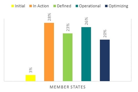
3.1. General Results of Assessment of the State of the SDI in the Americas

The survey was sent to 36 member countries of the region, of which 35 responded (Appendix A, Table A2), the results of which are presented below.
According to the categories established for the performance indicator, 3% (one country: Barbados) of the 35 Member States of the Americas region that responded is within the ‘initial level’ of implementation of an SDI; 28% (ten countries: Haiti, Suriname, Granada, Nicaragua, El Salvador, Guatemala, St. Vincent and the Grenadines, Guyana, Dominica and Sint Maarten,) at the ‘in action level’; 23% (eight countries: Costa Rica, Jamaica, Paraguay, Trinidad and Tobago, Antigua and Barbuda, Belize, Bahamas and St Lucia) at the ‘defined level’; 26% (nine countries: Argentina, Honduras, Peru, Uruguay, Venezuela, U.S.A., Dominican Republican, Chile and Panama) at the ‘operational level’; and 20% (seven countries: Canada, Ecuador, Bolivia, Colombia, Mexico, Brazil, and Cuba) at the ‘optimal level’ (see Figure 2 and Appendix A, Table A3).
If the levels are analyzed individually, it is at the ‘in action level’ where most of the Member States are located, and if analyzed together, most of the Member States (46%) are within the levels of development of a higher SDI—that is, ‘operational’ and ‘optimizing’, in comparison with those that are at a lower level of development (31%), corresponding to the ‘initial’ and ‘in action’ levels.
None of the Member States of the region achieved the maximum score (41) in the performance indicator; however, the four Member States with the highest scores obtained 39, 39, 38 and 37 points, respectively—scores that allowed them to be placed at the ‘optimizing level’, reaching almost the maximum scores in each of the four components. It is worth mentioning that in these Member States, it was identified that the components with the best rating were Human Resources and Technology. In this same level of the performance indicator (‘optimizing level’), there are five more Member States, but with a lower score, mainly in the Institutional Aspects component compared to the first four places.
On the other hand, in the lowest category of the performance indicator (‘initial level’) there are one member state (with a score lower than 21), which present values in the minimum limit in the Human Resources component and a low grade in the Technology component.
With respect to the other Member States (27), located in the levels ‘in action’, ‘defined’, and ‘operational’ (from 22 to 35 points) of the performance indicator, the best qualifications correspond to the Human Resources and Technology components.

3.2. Results for Each Component of the SDI

Regionally, the component in which more Member States reached the maximum score in the performance indicator was Human Resources with 37%, followed by Technology with 17%. In the Institutional Aspects and Information and Geographic Information, Norms and Standards components, less than 10% of the Member States reached the maximum score.
On the other hand, regarding the minimum scores, the only component in which no Member States had a minimum score in the performance indicator was Geographic Information, Norms and Standards. In the rest of the components, there was a member states that obtained the minimum score, in the Human Resource component.
Considering the relationship between number of Member States/Components of an SDI/level of development of the performance indicator (see Figure 3) the found results are as follows:
  • Regarding the Institutional Aspects component, most of the Member States (54%) are between the ‘initial’ to ‘defined’ levels, but only 14% are within the ‘operational’ to ‘optimizing’ levels, making it the third component of development in the region.
  • Regarding the Human Resources component, most the Member States (71%) are within the ‘operational’ to ‘optimizing’ levels, this being the component with the greatest development in the region.
  • Regarding the Geographic Information, Norms and Standards component, most of the Member States (54%) are within the ‘initial’ to ‘in action’ levels, this being the least developed component in the region.
  • Regarding the Technology component, most of the Member States (63%) are within the ‘operational’ to ‘optimizing’ levels; that is, it is the second component of development in the region.

4. Discussion

The Human Resources component holds the best performance rate in the region. This is related to the fact that in 86% of the Member States, the personnel in charge of the development of the SDI received training in topics related to geospatial information; that in 100% of the Member States, there are national academic centers that provide training in topics related to the development of geospatial information; and in 63% of the Members States, the SDI development team provides training on the subject to other organizations, which influences the fact that more personnel at the national level become familiar with the term and with the components that must be considered to develop an SDI.
Another component with good performance in the region is the Technological one, which is related to the fact that 94% of the Member States have mechanisms (web and mobile) defined for the disposition of the geographic information through the SDI or national Geoportal; 74% have web services that allow interoperability with other institutions; and 54% have hardware that responds adequately to the technological requirements of the national SDI.
The component Institutional Aspects has the third place of performance in the region, which is related to the fact that only 54% of the Member States have a formally constituted SDI, of which only 61% have a legal instrument that ratifies its existence—that is, only 31% of the Member States have a formal SDI that is legally supported. It should be noted that of the SDI set up, 50% is part of a regional SDI and/or is in international cooperation with other SDI, which reinforces the importance and the need for greater cooperation and alliances in the region that that allow for the increase, guidance and facilitation of the development of a national SDI. Likewise, another factor that hinders the development of SDIs in the region is that only in 54% of the Member States is there a definition of geospatial data infrastructure adopted by the organization in charge. This makes it difficult for the organization in charge of the production of geospatial data, and the other related organizations, to understand the importance of developing an SDI.
On the other hand, the Geographic Information, Norms and Standards component is the least developed in the region. It should be noted that 97% of the Member States have basic data sets and 80% use standards for metadata, catalogs, and web services. However, only 34% of Member States have national information standards of the ISO/TC211 committee; that is, special rules for the field of digital geographic information—such as simple access characteristics, reference models, spatial and temporal schemes, location-based services, metadata, classification systems, network characteristics, and map services [14]—and only 40% have a National Geographic Information Standards Committee, making it more difficult for the institutionalization of standards in most of the Member States of the region.

5. Conclusions

The level of development presented by a national SDI is an indicator of how effective the accessibility, distribution, and uses of geospatial data that is produced are. Therefore, a country with a high level of development in the implementation of an SDI has a greater exploitation of geospatial data to make decisions.
On the other hand, the lack in the implementation of a national SDI indicates that there is no organization and coordination between the geospatial information-generating institutions, which regularly leads to duplication of data, unnecessary production expenses, and inefficient use of the resources (human and technological) available.
That is why having an evaluation of the level of implementation of the SDI of the region of the Americas is of great relevance, since it allows for understanding of the strengths and weaknesses that the countries of the region have in the production and use of geospatial information, and in turn allows for the focusing of attention on the components that require more assistance. Likewise, the construction of the performance indicator is a solid mechanism to systematize the evaluation and to determine the level of progress that each country has in the development of its national SDI.
Regionally, out of the four components, the Institutional Aspects and Geographic Information, Norms and Standards are those that require more attention. In this regard, it is necessary to strengthen and implement well-defined and documented policy frameworks and mechanisms that support, formalize, and strengthen the use and production of geospatial information at the national and regional levels; which, in turn, drive technological advances, capacity building, and adoption by users. It is also critical to strengthen the use of geospatial standards, since it is the key element for an SDI to fulfill its objective of interoperability. One way could be through the OGC by means of a pilot like the one carried out for the Arctic SDI, in which it was shown that by using standards in the production of geospatial data, the wide variety of data available coming from various data sources can be interoperable.
Although the Human Resources and Technology components were the most developed in the region, it is vital to continue promoting the alliances and coordination of the geospatial data-producing organizations with the academia, since through educational and research institutes, the capabilities of production and use of geospatial information in the country can be developed and strengthened through specialized careers in geospatial subjects, certified courses, and research programs that promote innovation. Likewise, there must be collaboration between government agencies and the private sector in order to achieve larger investment in infrastructure and geospatial technology throughout the region.
Another determiniting collaboration of great importance is the regional one, such as the regional frameworks of INSPIRE and Arctic SDI, which demonstrate that collaboration efforts between national cartographic organisms in the regions allow for planning and implementation of geospatial solutions together, to access and share easily and efficiently regional geospatial data sets, facilitating monitoring and comprehensive decision making. In this respect, there is still much to be done in the region, since the implementation of a regional SDI represents an ambitious project that implies a great commitment of participation and collaboration at institutional, academic, and governmental levels.

Author Contributions

Conceptualization, P.M.G. and M.P.G.; data curation, M.P.G. and C.T.J.; formal analysis, M.P.G. and C.T.J.; methodology, M.P.G. and C.T.J.; supervision, P.M.G., G.G.S., and A.R.S.; validation, P.M.G., G.G.S., and A.R.S.; visualization, P.M.G., M.P.G., G.G.S., A.R.S., and C.T.J.; writing—original draft, P.M.G., G.G.S., and A.R.S.; writing—review & editing, A.R.S.

Funding

This research received no external funding.

Conflicts of Interest

The authors declare no conflict of interest.

Appendix A

Table A1. Questions from the survey on the status of spatial data infrastructure in the countries of the Americas and mechanism to synthesize the results.
ComponentQuestionsWeighting
Institutional Aspects1. Is there a formally constituted Geospatial Data Infrastructure in your country?1–0
2. Is there a definition of Geospatial Data Infrastructure adopted by the organization?1–0
3. What is the type of governing institution of the Geospatial Data Infrastructure in your country?1
4. Is there a legal instrument in your country that ratifies the existence of the Geospatial Data Infrastructure?1–0
5. What is the approximate annual funding allocated to the Geospatial Data Infrastructure of your country?1
6. What is the implementation model of the Geospatial Data Infrastructure in your country?1
7. Is there a management model that describes the organizational structure and how to develop the activities of the Geospatial Data Infrastructure in your country?1–0
8. Select the types of providers of the data arranged in the Geospatial Data Infrastructure of your country: Public entities, academia, private companies, citizenship, other.2–1–0
9. Are there institutional/legal agreements with the geographic information providers of the Geospatial Data Infrastructure in your country?1–0
10. Is there legislation in your country regarding the intellectual property of the geospatial information used by the Geospatial Data Infrastructure?1–0
Human Resources11. Are there training activities by the Geospatial Data Infrastructure team in your country to other organizations?1–0
Institutional Aspects12. Does the team in charge of the Geospatial Data Infrastructure of your country carry out research activities?1
13. In your country, does international cooperation exist with other SDIs?1
14. Is the Geospatial Data Infrastructure of your country part of a regional SDI or regional organization?1–0
Human Resources15. How many people are part of the Geospatial Data Infrastructure team in your country?1
16. What professionals make up the Geospatial Data Infrastructure team in your country? Geographers, Cartographers, Computer Engineers, Engineers, Geomatics, Engineers, Statistics, Other.2–1–0
Information, Standards and Geographical Standards17. Is there a set of basic or fundamental data? (core data)1–0
18. What data formats are most used in the platform or tool of the Geospatial Data Infrastructure in your country? Shape, KMZ/KML, TIFF, CAD, WMS, Other.2–1–0
19. In which languages are the data used in the platform or tool of the Geospatial Data Infrastructure of your country?1
20. How much digital data is available for viewing on the platform of the Geospatial Data Infrastructure in your country? 0–300/301–700/700–more.3–2–1
21. How much digital data is available for download on the platform of the Geospatial Data Infrastructure in your country? 0–100/101–350/350–more.3–2–1
22. Select the norms and standards used by the Geospatial Data Infrastructure of your country.1
23. Select the ISO geographic information standards used by the Geospatial Data Infrastructure of your country.1
24. Select the OGC standards used by the Geospatial Data Infrastructure of your country.1
25. Is there a National Geographic Information Standards Committee in your country?1–0
26. Does your country have national geographic information standards from the ISO/TC211 committee?1
27. Does the Geospatial Data infrastructure of your country give access to national standards?1
Technology28. Through what mechanisms does the Geospatial Data Infrastructure of your country dispose geographic information?2–1–0
29. What services allow interoperability with other institutions?2–1–0
30. Indicate the estimated number of annual visits to the platform or main tool of the Geospatial Data Infrastructure of your country.1
31. What type of software does the Geospatial Data Infrastructure of your country use for the information work?1
32. Do you consider that the Geospatial Data Infrastructure of your country has Hardware that adequately responds to the technological requirements of the Geospatial Data Infrastructure of your country?1–0
Table A2. List of countries and organizations participating.
Antigua and BarbudaSurvey & Mapping Division
ArgentinaNational Geographic Institute
BahamasBahamas National Geographic Information Systems Centre
BarbadosLands and Surveys Department
BelizeMinistry of Natural Resources-Government of Belize
BoliviaGeobolivia-Spatial Data Infrastructure of the Plurinational State of Bolivia
BrazilBrazilian Institute of Geography and Statistics-BIGS
CanadaCanada Centre for Mapping and Earth Observation (CCMEO)
ChileExecutive Secretariat SNIT-SDI Chile of the Ministry of National Assets
ColombiaAgustín Codazzi Geographical Institute/National Administrative Department of Statistics
Costa RicaNational Geographic Institute
CubaNational Office of Hydrography and Geodesy
DominicaLands and Surveys Division
EcuadorGeographic Military Institute
U.S.AFederal Geographic Data Committee
El SalvadorCNR-IGCN
GranadaLands and Surveys
GuyanaGuyana Lands and Surveys Commission
GuatemalaNational Geographic Institute
HaitiNational Center of Geospatial Information (CNIGS)
HondurasProperty Institute
JamaicaNational Spatial Data Management Division
MexicoNational Institute of Statistics and Geography INEGI
NicaraguaNicaraguan Institute of Territorial Studies
PanamaNational Geographic Institute Tommy Guardia
ParaguayDirection of the Military Geographic Service
PeruNational Geographic Institute
Dominican RepublicNational Geographical Institute José Joaquín Hungary Morell
St. LuciaDepartment of Physical Planning
Sint MartínMinistry of VROMI, Government of Sint Maarten
St. Vincent and the GrenadinesLands and Surveys Department, Ministry of Housing et. al.
SurinameMI-GLIS
Trinidad and TobagoSurveying and Mapping Division
UruguayMilitary Geographic Service
VenezuelaGeographic Institute of Venezuela
Table A3. Synthesized results.
CountryInstitutional AspectsHuman ResourcesInformation and StandardsTechnologyTotal scoreLevel
Canada13416639Optimizing Level
Ecuador14415639Optimizing Level
Bolivia13315738Optimizing Level
Colombia12414737Optimizing Level
México12415637Optimizing Level
Brazil12315636Optimizing Level
Cuba12414636Optimizing Level
Argentina11414635Operational Level
Honduras11415535Operational Level
Peru13313635Operational Level
Uruguay13411735Operational Level
Venezuela12413635Operational Level
U.S.A.10413734Operational Level
Dominican Republican11411733Operational Level
Chile8315632Operational Level
Panamá12410632Operational Level
Costa Rica9310729Defined Level
Jamaica8314429Defined Level
Paraguay9214328Defined Level
Trinidad y Tobago9211628Defined Level
Antigua and Barbuda8410527Defined Level
Belize8311527Defined Level
Bahamas10210426Defined Level
St. Lucia9310426Defined Level
Haiti7211525In Action Level
Suriname9210425In Action Level
Granada8210424In Action Level
Nicaragua6210624In Action Level
El Salvador6310423In Action Level
Guatemala6211423In Action Level
St. Vincent and the Grenadines5412223In Action Level
Guyana6310322In Action Level
Dominica5311221In Action Level
Sint Maarten6210321In Action Level
Barbados6110219Initial Level

References

  1. Paganini, M.; Petiteville, I.; Ward, S.; Dyke, G.; Steventon, M.; Harry, J.; Kerblat, F. Satellite Earth Observations in Support of the Sustainable Development Goals; European Space Agency: Paris, France, 2018; pp. 4–25. [Google Scholar]
  2. Yingjie, H.; Wenwen, L. Spatial Data Infrastructures; University Consortium for Geographic Information Science & Technology Body of Knowledge: Reston, VA, USA, 2016; pp. 1–2. [Google Scholar]
  3. UN-GGIM: Americas. Available online: http://www.un-ggim-americas.org/ (accessed on 6 April 2019).
  4. Zivkovic, L. Approach to Spatial Data Infrastructure Development for Spatial Planning in Serbia; Schrenk, M., Vasily, V., Popovich, P., Zeile, P., Elisei, P., Eds.; REAL CORP: Rome, Italy, 2013; pp. 85–93. [Google Scholar]
  5. Manso, M.; Wachowicz, M.; Bernabé, M. Towards an Integrated Model of Interoperability for Spatial Data Infrastructures; Transactions in GIS: Madrid, Spain, 2009; pp. 43–67. [Google Scholar]
  6. Natural Resources Canada. Geosemantic Interoperability Backgrounder; GeoConnections Hickling Arthurs Low Corporation: Ottawa, ON, Canada, 2015; pp. 1–6.
  7. Arctic SDI. Spatial Data Infrastructure (SDI) Manual for the Arctic; Arctic Council: Ottawa, ON, Canada, 2016; pp. 5–24. [Google Scholar]
  8. Myroshnychenko, V.; Ray, N.; Lehmann, A.; Giuliani, G.; Kideys, A.; Weller, P.; Teodor, D. Environmental data gaps in Black Sea catchment countries: INSPIRE and GEOSS State of Play. Environ. Sci. Policy 2014, 46, 1–12. [Google Scholar] [CrossRef]
  9. Delgado, T.; Lance, K.; Buck, M.; Onsrud, H.J. Assessing an SDI Readiness Index. In Proceedings of the FIG Working Week 2005 and 8th International Conference on the Global Spatial Data Infrastructure (GSDI-8), Cairo, Egypt, 16–21 April 2005; pp. 1–10. [Google Scholar]
  10. Delgado, T.; Delgado, M.; Espín, R. The Spatial Data Infrastructure Readiness model and its worldwide application. In A Multi-View Framework to Assess SDIs; Crompvoets, J., Rajabifard, A., van Loenen, B., Delgado, T., Eds.; The Melbourne University Press: Melbourne, Australia, 2008; Chapter 6; pp. 117–134. [Google Scholar]
  11. Rajabifard, A.; Williamson, P. The Need and Nature of Regional SDI for Middle East; The University of Melbourne: Melbourne, Australia, 2019; pp. 1–9. [Google Scholar]
  12. UN-GGIM: Américas. Estatutos, Comité Regional de Naciones Unidas Sobre Gestión Global de la Información Geoespacial para las Américas (UN-GGIM: Américas); UN-GGIM: New York, NY, USA, 2019; pp. 1–12. [Google Scholar]
  13. González, N.; Menéndez, J.L.; Seoane, C.; San Millán, M.E. Revisión y propuesta de indicadores (KPI) de la Biblioteca en los medios sociales. Revista Española de Documentación Científica 2013, 36. [Google Scholar]
  14. OGC. Available online: http://www.opengeospatial.org/ogc/partners/isotc211 (accessed on 10 May 2019).
Figure 1. General view of the Interactive Platform with the associated information available. The platform can be consulted on the UN-GGIM: Americas website [3]. UN-GGIM: Americas (Regional Committee of United Nations on Global Geospatial Information Management for the Americas).
Ijgi 08 00432 g001
Figure 2. Percentage of the Member States of the region in each of the implementation levels of a spatial data infrastructure (SDI).
Ijgi 08 00432 g002
Figure 3. Ratio of the percentage of Member States by components of an SDI, by development level of the performance indicator.
Ijgi 08 00432 g003
Table 1. Maximum and minimum ratings by component.
Score by ComponentInstitutional AspectsHuman ResourcesGeographic Information StandardsTechnologyScore Total
Maximum14416741
Minimum516216

