
Policy Strategies to Revive Rural Land in Peri-Metropolitan Towns: Resource Identification, Capitalization, and Financialization


1
Southern Marine Science and Engineering Guangdong Laboratory (Zhuhai), Zhuhai 519000, China
2
School of Geography and Planning, Sun Yat-sen University, Guangzhou 510275, China
3
Chinese Academy of Social Sciences, Guangzhou 510000, China
4
Department of Architecture and Urban Planning, Institute of Urban Planning and Design, Nanjing University, Nanjing 210093, China
*
Author to whom correspondence should be addressed.
Land 2021, 10(2), 132; https://0-doi-org.brum.beds.ac.uk/10.3390/land10020132
Submission received: 11 December 2020
/
Revised: 26 January 2021
/
Accepted: 26 January 2021
/
Published: 29 January 2021
(This article belongs to the Special Issue Land Management in Territorial Planning: Analysis, Appraisal, Strategies for Sustainability)
Abstract
:Previous planning for rural revival in towns has emphasized construction and government-led policies. However, we argue that the dilemmas of peri-metropolitan rural areas, such as Desakota in China, are far more complex faced with rural super village and hollowed village transformations. Rural revival planning needs to coordinate with the development of urbanized and rural areas towards multifunctional goals and plans as a whole. Therefore, we selected the town master plan of Lijia, a typical peri-metropolitan village in China, as a case study. Through a historical–interpretative approach involving analysis of planning policies, questionnaires, and in-depth interviews with the key stakeholders involved, we structured the process and mechanism of rural revival in Lijia into three phases: resource identification, capitalization, and financialization. In different phases, different stakeholders adopt different roles. The government takes a leading role in resource identification and capitalization, while firms take a leading role in the process of financialization. “Market-dominant and government-guided” planning stimulates villagers to participate in rural revival. We highlight the importance of multifunctional land-use in terms of rural revival in the master planning of peri-metropolitan villages and provide a practical reference for uniting multiple stakeholders, including governments, firms, and villagers.
1. Introduction
Although the 21st century is said to belong to cities, the need for rural studies has never been more urgent [1,2]. As rapid urbanization and industrialization have caused increasing rural–urban disparities and rural land degradation, the revival and renaissance of rural areas have attracted increasing attention in terms of geography and urban planning [3,4,5]. Discussions over rural agricultural land, rural communities/settlements, and rural industrial land, including tourism, are central issues in rural revival [6,7,8,9,10]. However, our knowledge regarding multifunctional land-use for rural revival in the peri-metropolitan fringe is relatively weak [11,12].
By contrast with the natural decline caused by disasters and exhausted land resources, the dilemmas of peri-metropolitan rural areas such as Desakota, China are far more complex [13,14,15]. Against the context of Desakota, a special urbanization phenomenon, these peri-metropolitan rural areas are semi-urbanized and face both spillover and siphon effects from metropolitan regions. On the one hand, dramatic spatial restructuring of land-use over-transition from agricultural or ecological land to construction land can lead to the development of “super villages” [16,17,18]. The negative effects of farmland occupation and the alienation of “villages” have occurred when disorder expansion reaches its ceiling [19]. Much of the relevant research has discussed the renewal of industrial land in peri-metropolitan villages; however, it is also necessary to discuss the renewal of non-industrial land, including rural abandoned settlements and ecological land [20,21,22,23]. Nonetheless, it is still pertinent to understand how to maintain a village’s rural characteristics and protect its ecosystem when optimizing the structure of land use in peri-metropolitan villages. On the other hand, metropolitan regions have attracted large population inflows from nearby rural areas, and semi-urbanized rural areas have faced the displacement of villagers and the loss of human resources. The severe degradation of rural land has led to the development of hollowed villages [24,25]. It is also important to understand how to consolidate rural construction in an intensive economy and revive its economic vitality to attract villagers back.
In fact, these two kinds of rural transformation, super villages and hollowed villages, are two extremes in peri-metropolitan rural areas with a drastic rural–urban relationship. Without suitable guidance and planning, peri-metropolitan villages are easily locked into these extremes. Recently, planners have realized this problem and paid more attention to rural planning by focusing on the development of central areas while neglecting other social, cultural, and ecological places. We argue that rural revival planning needs to coordinate with the development of urbanized and rural areas towards multifunctional goals and plans as a whole. Although the decreasing population is still engaged in agriculture, peri-metropolitan villages have rich natural resources and traditional culture with high potential for ecological and social services. Local governments must develop special policy strategies for attracting businesses to utilize these resources. In addition, merely depending on government-led planning is not enough [26,27]. It is necessary to introduce market forces from metropolitan regions to coordinate diversified stakeholders and to form a “growth alliance” for rural revival [28,29,30].
Lijia is a typical Desakota town in China. It is located on the fringe of the Shanghai metropolitan region and the high-technology zone of Changzhou city. With this advantageous location, Lijia rapidly developed in the late 1980s under rural industrialization and became one of the country’s largest production bases for suitcase fabric and refrigeration equipment. Nevertheless, this rapid rural industrialization caused a series of constraints, including excessive constructional land with low efficient land-use, severe environmental pollution, and the loss of youth interest. Over the past decade, the increased rate of economic development in Lijia has slowed down, with the town ranking in the last fifth of the Wujin district of Changzhou city. Lijia has become a penumbra of the nearby metropolitan fringe.
Faced with the dilemma of both hollowed villages and low-efficiency expansion, Lijia planners have decided to change the traditional planning mode of “government-dominant and manufacturing-first” to “market-dominant and government-guided”, especially towards multifunctional land-use. The recent literature has discussed the evaluation system and assessment of multifunctional land use, while few authors have discussed policy strategy [31]. Therefore, we selected the strategy of master planning in Lijia as a sample case study to answer the following two research questions regarding rural revival:
- (1)
- How can we revive rural land, especially abandoned nonindustrial land, for the multifunctional land use of sustainable development in a peri-metropolitan town?
- (2)
- How can we coordinate various stakeholders in “market-dominant and government-led” planning to build a solid growth alliance based on mutual trust in order to achieve a harmonious urban–rural relationship?
This research highlights the importance of multifunctional land use for rural revival amid rural planning in peri-metropolitan villages. Furthermore, we provide practical recommendations on uniting multiple stakeholders, specifically integrating economic forces and political forces. To address the strategy of resource utilization, capitalization, and financialization in the town’s master planning, we first conduct a literature review of the multifunctional transitions in the peri-metropolitan town and introduce the development history of Lijia. Then, through a historical–interpretative approach involving analysis on planning policies, we conduct questionnaires and in-depth interviews with key stakeholders, and structure the process and mechanisms of rural revival in Lijia. Finally, we discuss potential future studies.
2. Literature Review: A Multifunctional Transition in Peri-Metropolitan Towns
Numerous studies have discussed the concept of multifunctional rural transition in Western and Chinese contexts. Holmes provided a triangle framework with “production-consumption-protection” based on the concept of a “post-productivist transition” [32,33,34]. In the context of Western rural transition, such as in Australia, the shift from a production-dominant goal to a mix of production, consumption, and protection goals was linked to overcapacity of food production, market requirements, and the social value of sustainability. In this framework, the mode of peri-metropolitan occupancies showed intense competition between production, consumption, and protection values. In addition, Wilson classified the multifunctional transition into productivist and non-productivist actions in relation to the different types of ownership of farmland [33]. Renting et al. developed four research approaches for multifunctional rural transition, i.e., market regulation, land-use approaches, actor-oriented, and public regulation approaches [35]. These approaches emphasized the background of the social change process of market liberalization towards sustainability, and the contribution of rural land to food security, wellbeing, and resource conservation [29,35,36]. Therefore, the experience for most developed countries has shown that, in the early stage of urbanization, the function of cultivated land is mainly focused on food production. The transformation, however, is towards rural development and ecological management. With the rapid development of urbanization, non-commodity production functions become dominant.
Although China appears to be in a similar rural development transformation, the background of Chinese rural transitions is different, as the country experiences both top-down and bottom-up rural industrialization, urbanization, and modernization processes [37]. The main task for central government is to emphasize multifunctional land use in terms of production, lifestyle, and ecology, as well as to control the disorder of constructional land and integrate lifestyle and ecology functions in order to optimize the land-use structure. In particular, in Desakota, the economic and social activities show both urban and rural features in peri-metropolitan villages. Tu et al. revealed the evolved functions from traditional agriculture to the industries of primary processing and eco-tourism in Huangshandian village, in the suburbs of the Beijing metropolitan area. Traditional agricultural production declines without overcapacity and is further transformed by the governmental policy comprehensively promoting “production–living–ecology–culture” functions [38]. Qu et al. identified multi-functional rural settlements in sub-hotspots near Jinan city, and considered it the result of combining natural and geographic conditions, traffic locations, policies and systems, population, economy, and regional culture [39]. Clearly, in Chinese peri-metropolitan villages, it has become an increasing trend to develop multifunctional land-use approaches to solve the conflicts between demands for sustainable development and decreased land-use. Additionally, this is a sustainable approach to avoid the shadow effects of metropolitan regions.
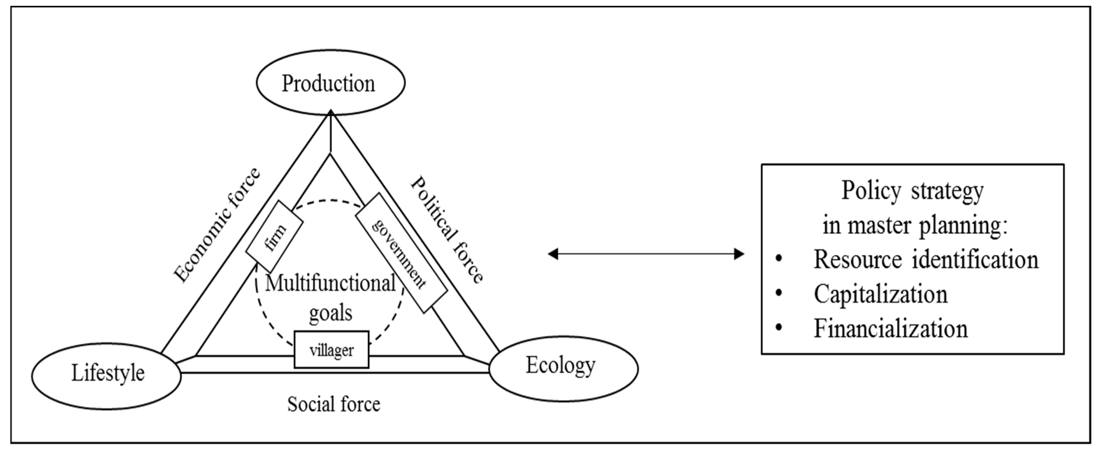
Based on these findings, our analysis framework of multifunctional goals is related both to multinational land-use with sustainability and diversified stakeholder benefits and rights [29,40] (Figure 1). Scholars have found that friendly public–private partnerships helped in the development of land-management processes [41,42,43]. Based on this study, we believe that the optimized mode and regulation policies for the multifunctional evolution of rural land need to be further investigated, covering more stakeholders. First, the government plays a leading role in master planning and should take responsibility in the form of coordinating the attraction and stimulation of diverse stakeholders to join in with rural revival. Some scholars have revealed the planning policies of “building a new countryside” and “increasing vs. decreasing balance”. As such, land-use policy has made a great impact on rural spatial transformations [19,24,27]. With China’s distinctive political and land-use system context, there is no doubt that government needs to take a leading role in developing multifunctional land-use goals during master planning. Second, bottom-up initiatives, including rural cooperation and collective organization, need to be unified and integrated into the alliance as a whole. Rural restructuring is a dynamic and hybrid process, strongly shaped by local power and local villagers. The strong “voices” from local stakeholders are an essential part of master planning [44]. Third, firms including manufacturing, service firms, and real estate should be motivated to develop actionable strategies [45,46]. Firms are high-efficiency actors in the market, connecting governmental and social forces. To summarize, to integrate the top-down and bottom-up approaches into rural revival is to coordinate various stakeholders from the government, firms, and villagers towards the achievement of multifunctional sustainability goals.
3. Materials and Methods
3.1. Study Area
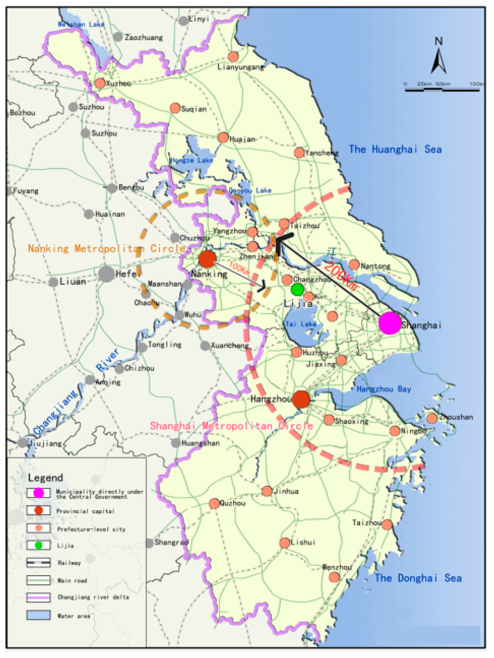
Lijia is located in the southeast of the Wujin district, Changzhou city, close to the Wujin national high-tech zone. Moreover, it is on the fringe of the Shanghai and Nanjing metropolitan regions (Figure 2). Its area comprises 58.23 km2 and it contains 14 villages with 27,958 households and a permanent population of 88,908. It is about 10 km away from the central Wujin district and 170 km away from Shanghai. The town is named after the Lee family’s bridge, and it is famous for its 10 bridges, which are more than 100 years old. With 865.61 hectares of river surface, occupying 14.87% of the town’s area, Lijia has rich resources and village characteristics. However, according to the official 2015 report on land-use quality, this resource was not utilized as most rivers are polluted. Some of the most severe causes of dissatisfaction that villagers complained of were the environmental pollution of rivers and the shortage of public leisure places.
Another remarkable feature of Lijia is the unbalanced development of manufacturing and service. In 2015, the manufacturing sector occupied 59.9% of the gross domestic product (GDP) value, while the service sector occupied 37.1%. In 2019, manufacturing increased and occupied 64.76% of the GDP value, while the service sector decreased to occupy 31.71%. The average scale of business is small and the production service level is low. Slow development in the service industry has limited residents’ consumption and manufacturing upgrades.
The third feature of Lijia is its high percentage of stock land, which occupies over 5% of construction land (68.83 hectares), comprising 36.73 hectares in the central construction area and 32.10 hectares in rural villages along the rivers. The stock land in the central construction area is spread along the main road, on low-quality industrial land, while in rural areas it is spread in hollowed villages with poor conditions.
The fourth feature is the “bottom-up” form of local governance. Collective cooperation has strong power in rural economic development and contributes more than 50% of income for local villagers. However, collective cooperation has mostly invested in manufacturing industry and rarely in the service industry. In addition, most villagers are engaged in nonagricultural production and, in 2014, their per capita income was more than 15,000 yuan. From our investigation, collective cooperation and local villagers have the ability and ambitions to upgrade their industry and develop the service sector.
3.2. Data and Methodology
Our research methods included a historical–interpretative approach involving analysis of planning policies, questionnaires, and in-depth interviews. First, we analyzed a series of planning policies about Lijia, including the master planning series (2004–2020; 2007–2020; 2016–2020), the rural planning of Lijia villages (2014–2030), and the upper level of Changzhou city planning. As Table 1 shows, in accordance with the planning framework, we made a comparative overview of planning concepts and their policy strategies for three master planning series (2004–2020; 2007–2020; 2016–2020). These planning materials help us make the development phases of policy implementations clear.
Second, in order to establish a connection between the planned and the realized process of the implementation of the multifunctional goals of policies, we collected data from two rounds of questionnaire surveys and in-depth interviews. The first round of questionnaire surveys was conducted from July to September 2014 in Lijia, which was designed to collect information on the appeal of the Lijia master plan to villagers. The questionnaires consisted of three sections: (1) demographic characteristics; (2) evaluation of current constructions; (3) suggestions for future development (Appendix A). Six hundred and forty questionnaires were sent out in 14 villages across the whole town at random and 635 questionnaires were valid. The effective response rate was 99.22%. Table 2 reports the socio-demographic structure of the samples. According to the survey, 64% of the respondents were male and 85% were local villagers. In total, 14.3% of the respondents were in the 0–29 age group, 56.1% in the 30–49 age group, and 29.6% in the over 50 age group.
The second round of questionnaire surveys was conducted in May 2015 in Dapu village. The vacancy rate of rural settlements in the village was 48.3% in 2015, meaning that it was one of the most severe hollowed villages in town, and so it was chosen as the experimental basis upon which to practice planning policy by the township government. The purpose of the second round of questionnaires was to identify the possibility of transforming the abandoned rural settlements into available land resources via the implementation of master planning. We distributed 180 copies of questionnaires to all households registered and received 93 effective responses, as the 64 remaining homeowners lost contact (left the village for a long time or died), while 23 homeowners settled down in the city and did not care about issues related to the village. The main questions concerning abandoned settlements are as follows: (1) How many houses that you own have been abandoned? (2) Why did you abandon your house? (3) How do you deal with your abandoned house? (4) Do you want to transform your abandoned house(s)? If yes, in which way would you prefer to transform the house(s)? (Appendix A).
Third, we conducted in-depth interviews focused on the process and influence of master planning from the experience of economic, social and political stakeholders. A semi-structured interview questionnaire was prepared (Appendix B). Interviewees were conducted with 15 local residents who worked in the collective group and had a clear idea regarding the multifunctional goals of the planning, and 5 government staff who played a main role in designing the policy framework, as well as 10 local entrepreneurs, who actively took part in the implementation of the planning. All participants gave their approval regarding audiotaping and transcription, which helped us to understand the real phases of the policy strategy.
4. Findings and Discussion
By combining analysis of planning materials and interview data, we concluded that our rural revival strategy directed toward multifunctional goals occurred in three phases. The first phase identified potential resources as valuable stock land in multifunctional types. The second phase capitalized on and targeted the transformation of stock land in terms of different capital functions. The third phase dealt with financial investment in cooperation with various stakeholders. Because development conditions in Lijia are complex, planners adopted a classification lens to enact this policy and tried to revive the rural land in terms of productive, ecological and cultural functions.
4.1. First Phase: Resource Identification of Multifunctional Types
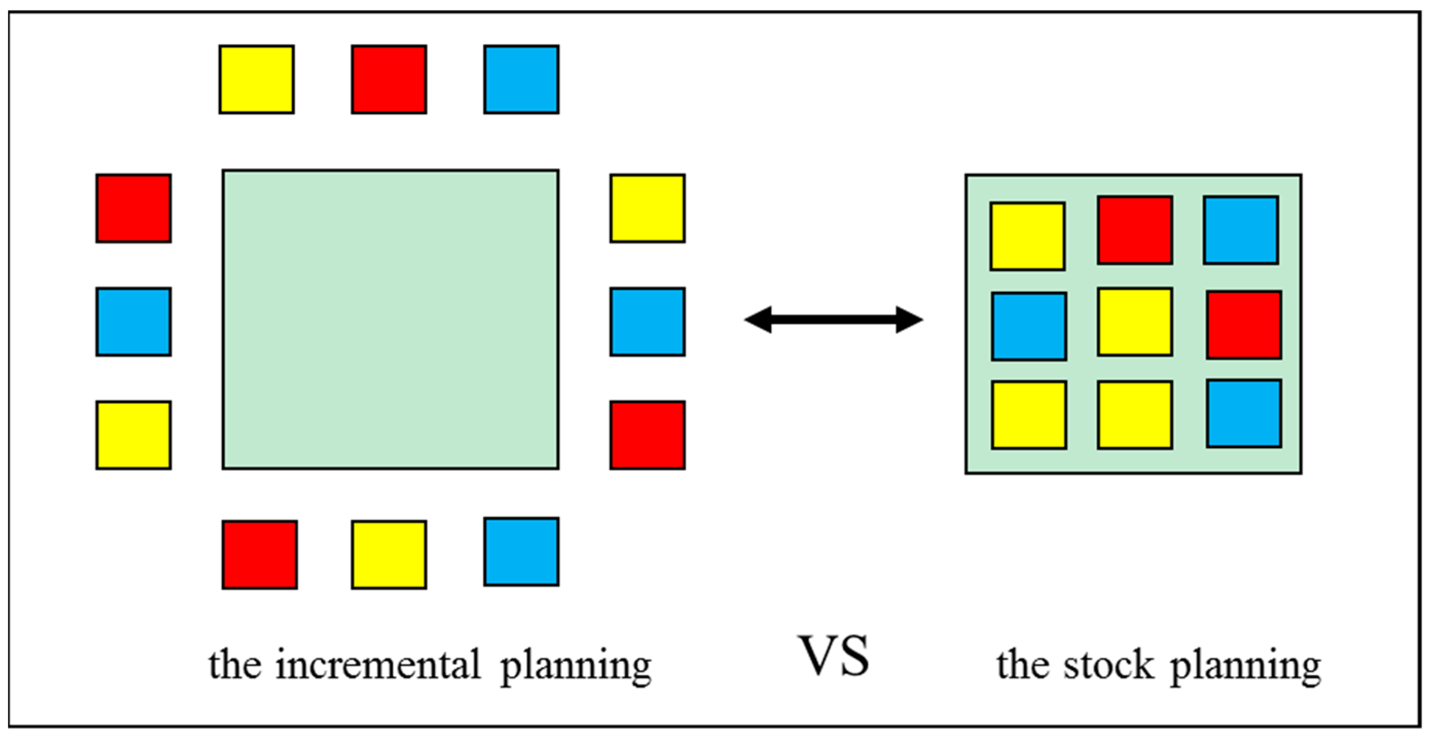
The first phase towards multifunctional land-use in the current master plan was to identify potential stock land resources in terms of social, cultural, economic, and ecological functions instead of merely economic functions. Based on a contextual analysis of previous plans from 2004 and 2007, we found that their main policies preferred the incremental transformation of construction land to develop manufacturing industry, as this was a priority in Lijia. In contrast to previous incremental plans, the current master plan tends to represent a new method of stock planning (Figure 3), which emphasizes the improvement of land-use efficiency and the renewal of abandoned rural areas for social, cultural, economic and ecological progress. Therefore, this changed the priority label and added the characteristic of “green innovation town” to Lijia.
One government officer explained the main progress of the current policy, referring to the intensive and green development model: “In our previous master planning, we did not consider the social and ecological development in rural villages well and took an economic development model in an extensive and inefficient way, which caused disorderly expansion of rural construction. In the new era, central government has strict policies for protecting farmland and limiting the expansion of rural construction. With the limited land resource of the rural area, it is necessary for local governments to transform the development mode in an intensive and green way and make detailed guidelines for the stock land use”.
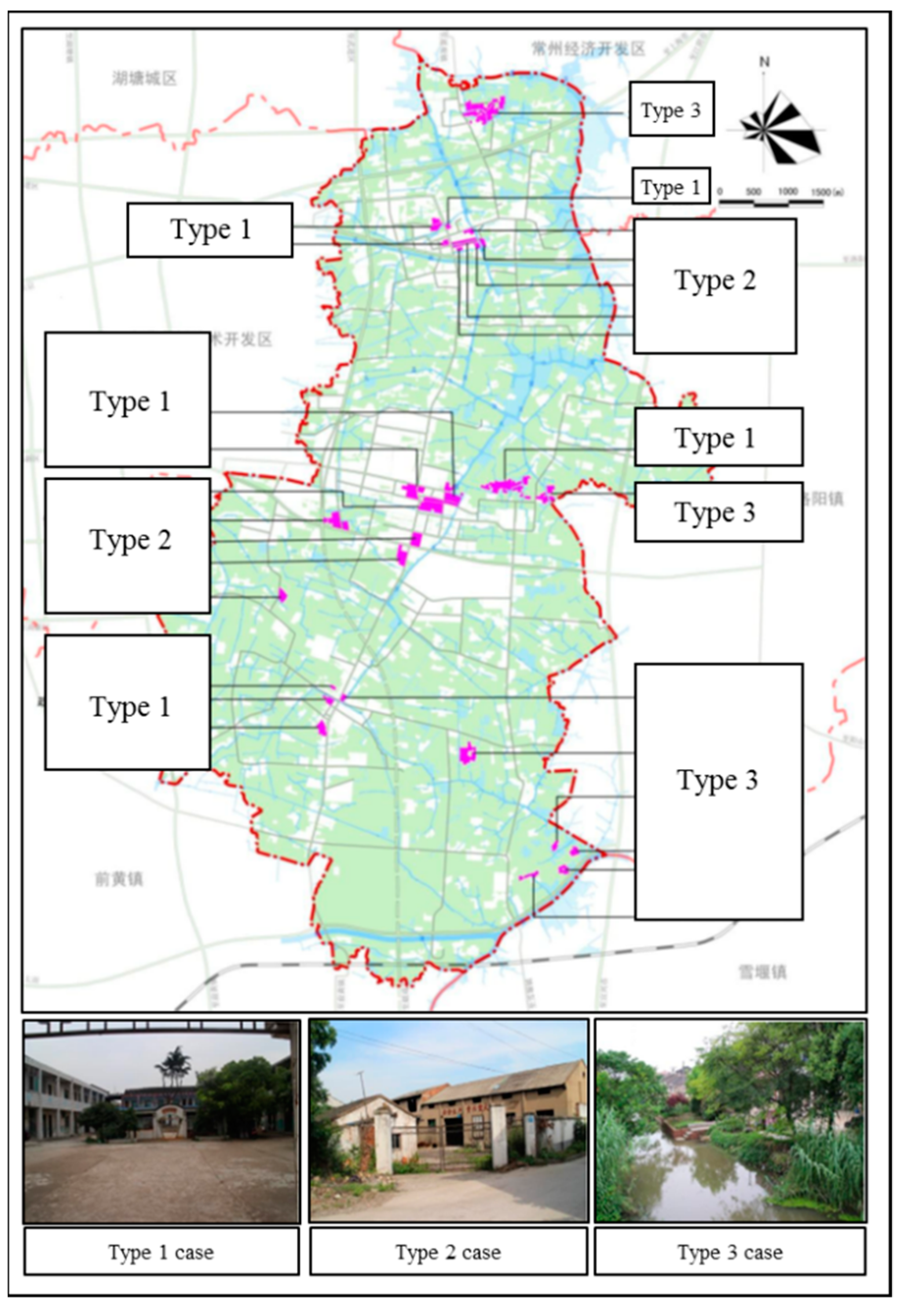
In the guideline policy, there are three types of stock land that can be transformed into mobile resources for social, cultural, economic, and ecological functions based on construction conditions, land-use efficiency, and ownership complexity (Figure 4).
Type 1: Abandoned public buildings, including abandoned schools, office of food administration, and agricultural technology stations. Ownership of these buildings and land are clear and simple, i.e., they belong to a township government. With appropriate renovation, these buildings can be transformed into important public facilities in social functions of land use to improve villagers’ sense of wellbeing.
Type 2: Low-efficient land-use of industrial land in central towns includes township industrial zones, and collective-owned industrial zones. Ownership of these factories and land is not complex, as they usually belong to township governments or several village collective groups. With unified planning and coordination, these industrial zones can be renewed as potential bases for high-tech industries with highly efficient land-use.
Type 3: Abandoned private buildings with historical, cultural, and natural landscapes, such as historical hollowed villages and waterfronts in Dapu, Banqiao, and other long-history villages. These old buildings are not on the list of historical and cultural protection buildings by regulations. However, they maintain a unique traditional architecture of waterfront buildings with surrounding ditches for rivers. With appropriate renovation, these rural landscapes can be transformed into tourism areas for urban residents.
During the implementation of the policy related to resource identification, the transformation of type 3 was the most difficult work, as ownership of abandoned private buildings and reasons for abandoning these buildings were complex. Taking Dapu village as an example, the reasons for abandoning settlements include owning houses outside the village (26.4%), working outside and seldom returning (21.8%), building a new house without demolishing the old one (18.4%), the owner—usually old men—having died (12.3%), and other unclear reasons (20.7%), as Table 3 shows. One villager in Dapu said: “I have two brothers. All of us left the village and worked in Changzhou city in 2000. When I bought the four-room flat in the city, I invited my parents to live with me and helped look after my children. In 2005, my parents moved to my other brothers’ flats to help them look after their children. Therefore, in the past two decades, my parents did not have time to go back home. We did not go back to our hometown village until the Spring Festival. The old houses were dirty as no one lived there.” In addition, different villagers exercise different judgement and treatment regarding their private buildings. In total, 54% of villagers rented their old house to immigrants, while 14.9% of villagers rebuilt their old houses and converted them into small convenience stores (Table 4). In this process, the township government plays an important role in identifying resources and negotiating with villagers and collective groups to improve the efficiency of land use. As one government officer claimed, “more abandoned rural settlements, more waste of precious land. In the previous sense, an abandoned rural settlement was not worth investing in as they only offered accommodation for villagers and immigrants. However, in the new plan, rural settlements were treated as special rural landscapes in rural tourism, which need government guidance and support to restructure the landscape.” In our investigations, 62.4% of villagers were willing to have a third party repair their abandoned house for greater revenue, which gave township governments a chance to take part in the renovation process.
In the first phase of the policy strategy, the master plan identified three types of potential land resources in multifunctional principles to create a new pattern of stock land planning.
4.2. Second Phase: Capitalization in Different Functions
After resource identification, a transfer program (i.e., capitalization) was designed to clarify the subject and pattern of transformation and to optimize the multifunctional structure of land-use. In this process, the guideline policy offered three paths of capitalization that transferred three different types of stock land resources into various development capital.
Path 1: Demolition and reconstruction of abandoned public buildings, which generates reserved land or cultural space. Based on residents’ evaluation comments of current constructions, there were 143, 186, 131, and 191 comments on the insufficient public space in civil squares, playgrounds, libraries and welfare centers, respectively, which drew attention to the plan in terms of social and cultural construction. The policy recommended that township governments adopt the main responsibility of transforming abandoned public buildings into social and cultural capital to create social harmony. For example, offices of food administration are evidence of a village’s agriculture development history, which can be rebuilt as an education base for students or a cultural consumption location for young people.
Path 2: Upgrading constructional conditions in industrial zones to attract high-value innovative industries. Some industrial zones with advantageous locations were built in earlier times, but require an improvement in terms of their structural quality, while some industrial zones have poor surrounding facilities and environments, which require comprehensive renovation to beautify them. Firms in industrial zones and local governments will need to aspire to achieve these transformations, a topic which was discussed in our previous paper [47].
Path 3: Comprehensive renovation of private buildings to attract urban dwellers. From the survey, nearly 52% of villagers suggested developing tourism to revive old villages. However, it was significant for rural households to involve and make a large-scale plan to attract urban inflows of capital, people, information, and knowledge, a process which needed a strong political group to call for the right of use of scattered old buildings and the unification of rural households.
Guided by the policy of the third path, some old private houses need to change their ownerships to collective groups first for further unified investments. Township governments helped build up town-led service stations and village-led substations for rural homestead circulation. The main task for these service stations was to persuade owners of abandoned houses to sell their buildings or sell stock to transfer the rights of building use to the collective group. From our findings, most villagers paid more attention to the spiritual and cultural value of the old houses. They kept the rights of buildings not only to earn money, but also to honor their ancestors. Therefore, the process of persuasion also emphasized the heritage of rural culture and family traditions during the protection of valuable parts of old buildings and innovation. These service stations dealt with different requirements and offered a flexible plan to meet their requirements. These private buildings would be transformed into cultural facilities and ecological facilities to support tourism development.
In the second phase of policy strategy, the master plan offered three types of transformation direction and suggested key actors to mobilize valuable land resources for different functions.
4.3. Third Phase: Financialization with Various Social Funds and Investments
The third phase of the strategy policy was to utilize social, ecological, and cultural capital to attract various social funds and investments. There are three types of financialization strategies related to the cooperation of partners.
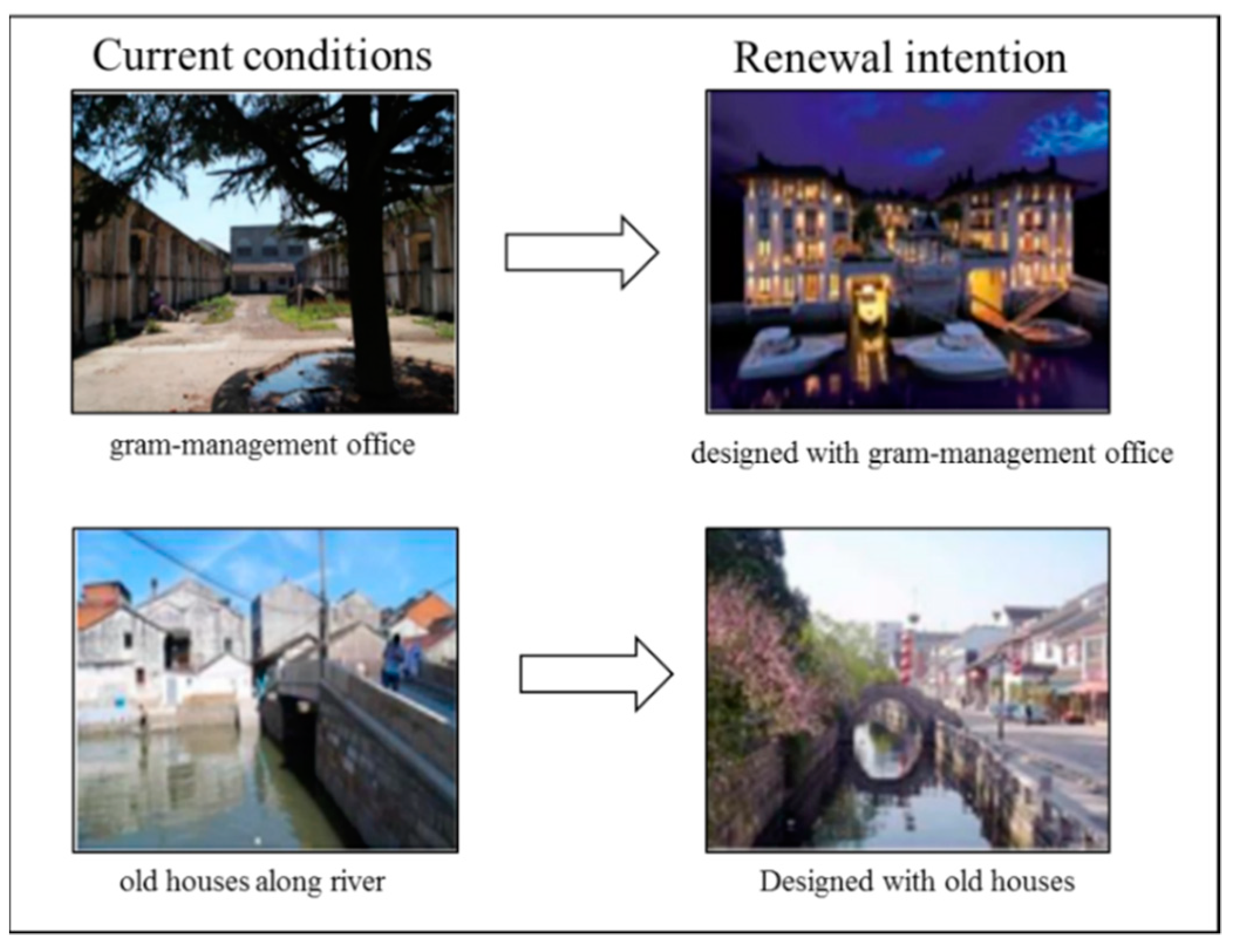
Type 1: Cooperating with cultural firms or social organizations for socioeconomic development. During our interviews, we found several successful cases guided by the first type of policy. For example, the office of food administration was built to allocate national grain resources in the 1950s. Some paintings in the office reflected the social conditions of the time. One manager of a famous cultural firm said: “I appreciated these paintings and considered them to be important historical artifacts worth of protection”. He invested in a project with the local government to modify these historical paintings and transform the management office into a tourism and consumption site, as Figure 5 shows. In addition, two abandoned public schools were renovated into two public libraries, supported by welfare organizations.
Type 2: Cooperating with firms to develop rural tourism and a retirement industry. Villages have pleasant natural and rural landscapes that metropolitan areas cannot provide. Enterprise has the ability to improve the surrounding environment and build up convenient supporting facilities to attract urban residents. One government officer approved a project on “beautiful village construction” in Dapu village cooperating with a famous real estate firm to develop rural tourism guided by the second type of policy. One manager at a tourist agency explained that “Rural tourism is becoming more and more popular in metropolitan regions for people with different life experiences. Some old villages in Lijia town have advantageous cultural and natural conditions. With appropriate investments, they will become popular tourist destinations”. The master plan also illustrated that, for some old men, such tourist excursions recalled childhood memories of when they travelled to rural places and, thus, they realized that they wanted an environmentally friendly place to spend their weekends or even the rest of their life, thereby attracting investment in the retirement industry.
Type 3: Cooperating with the creative class to develop the cultural industry and its ensuing tourist market. With a desirable environment and low rents, artists and designers would be willing to repair old buildings to begin their creative work, which may also attract young people from cities. One manager at a real estate company showed interest in the investment of a cultural gallery, explaining that, “The historical environment with unique landscape is one of the best places to inspire and attract creative classes”. In addition, villagers were willing to rent their abandoned houses to cultural firms. One villager said “Last year, I rented my old building to immigrants and they did not care about protecting the structure. This year I stopped renting and abandoned the old building. If there are specific firms taking care of my house and sharing my profits, I would be willing to rent to them”.
In the third phase of policy strategy, the master plan offered three types of financialization in cooperation with different firms and social groups. In the real implementation, we found that cultural firms and real estate enterprises showed great interest in this cooperation.
5. Discussion
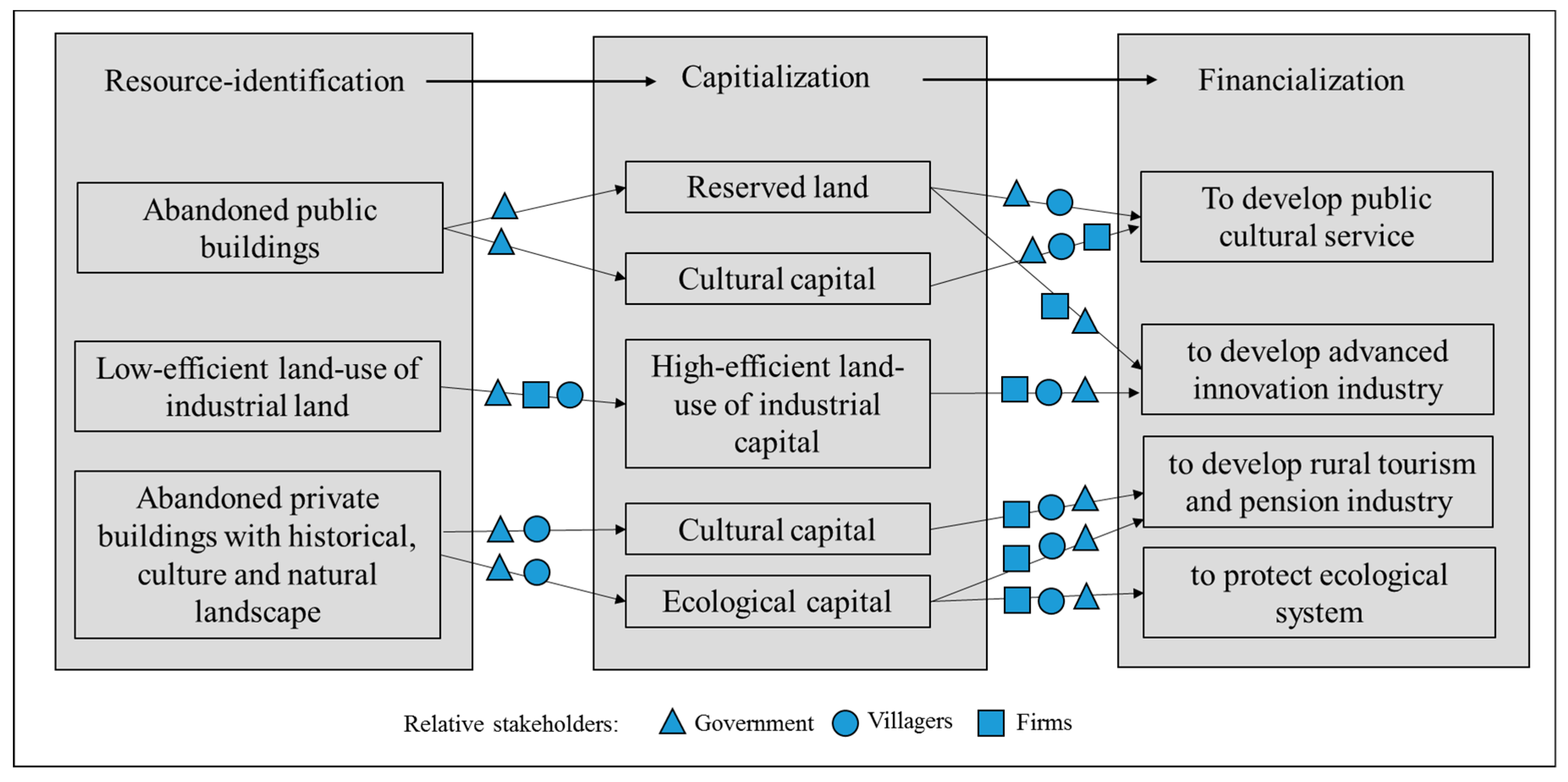
By connecting policy and the implementation carried out, we explored dynamic stakeholders in the rural revival process. As Figure 6 shows, in the resource identification phase, township government and collective groups adopt a leading role in the exploration of stock land in multifunctional land use. Not only industrial land, but also non-industrial land, including abandoned public spaces and rural settlements, are identified as valuable land resources in the planning policy. When there is a conflict of interest with villagers during the policy implementation, they negotiate. Collective groups negotiate with villagers to explain the goals of transformation and provide several compensation plans to guarantee villagers’ rights. The negotiation process is considered a coupling process with interests of the individual villager and collective groups [48]. Most compensation plans include several options for guaranteeing villagers’ and collective groups’ economic benefits. In the new master plan, besides different methods of income, rural culture and villagers’ livability were also included. In particular, for the abandoned public buildings and old, traditional buildings, township governments prefer to transform them into public service infrastructure. This transformation towards rural livability needs to be discussed further [49,50]. In the first phase, the township government carefully deals with this negotiation process to avoid social conflicts with villagers.
In the phase of capitalization, three types of valuable stock land can be changed. In the plan, governments outlined the main guidance for these change directions. As villagers usually consider the economic potential first, the township government considers villagers’ opinions and balances them with socioeconomic development and environmental protection. Under the guidelines of multifunctional goals, abandoned non-industrial land can be transformed into cultural and ecological capital to satisfy villagers’ desire for a better life with a higher-quality lifestyle and ecological environment.
In the phase of financialization, firms take the leading role to utilize the available capital and to generate long-term profits. Tourism firms, cultural firms, and real estate construction firms from metropolitan regions provide an attractive plan of renewal and profit distribution to governments. Similar to the negotiation process with villagers in the first phase, local governments and collective groups attempt to negotiate with firms to balance the developmental requirements and environmental protections without hurting villagers’ benefits. In this process, villagers assist the collective group to supervise the cooperative projects run by firms. They do not need to negotiate with firms as they already delegate their rights to the collective group in the first and second phase.
The master plan set the planning mode as “market-dominant and government-guided”; therefore, the negotiation process becomes regular and common during the three phases to maximize the rights and interests of stakeholders from the government, firms, and villagers. This working paradigm is different from “government-dominant” planning and stimulates villagers to join in with the rural revival. From the experience of Lijia, through negotiation and dialogue, governments, firms and villagers have found it easier to reach a consensus and to develop multifunctional goals. Some studies in the literature have improved upon this [51].
6. Conclusions
In this paper, we investigated a master plan policy strategy, specifically for resource identification, capitalization, and financialization processes in order to realize multifunctional goals in a peri-metropolitan town. Connecting the master plan policy and realistic implementation, we provided an action procedure for planning the transition from “manufacturing-first with government-led” to “multifunctional goals with market-dominant and government-guided” in Lijia, China. Moreover, we highlighted the importance of integrating market forces with political forces in the three phases of strategic policy.
Against the background of Desakota, China, Lijia faces complex conditions in the development of the economy, society, culture, and ecology. To avoid the problems presented by previous incremental plans, the new master plan emphasized the revival of rural abandoned areas into valuable stock resources, which is the main characteristic of stock land planning. This included the revival of non-industrial land, such as abandoned rural settlements and abandoned public buildings. The policy identified that abandoned land can be transformed into valuable social, cultural and ecological landscapes instead of merely being used as industrial land. In addition, through capitalization and financialization, different types of firms and social groups are invited to help develop various industries and utilize land for multiple functions. Underlying the “Beautiful Village in Beautiful China” concept in the current master planning of towns, the comprehensive considerations of economic, social, cultural, and ecological development require various policy frameworks for multifunctional land use [52,53]. The Lijia case reveals the implications regarding the policy framework in combination with cultural and ecological elements in the revival of abandoned non-industrial land.
These transformations are related not only the goals of multifunctional land use, but also the rights of various stakeholders. In our case, governments, firms, and villagers are unified in the rural revival process. In each phase of the action procedure of planning, the role of the stakeholder differs. The township government and collective group takes the leading role in the phases of resource identification and capitalization. They negotiate with villagers, not only protecting villagers’ economic benefits, but also protecting villages’ culture and social communities [50]. In the phase of financialization, firms take the leading role in investments. Local governments and villagers assist the investment and help it to run well.
To coordinate the various stakeholders in the “market-dominant and government-guided” plan, there is a need to set up clear functions for each stakeholder during the action procedure. Overall, we suggest that multifunctional goals towards economic, social, cultural, and ecological development provide a practical reference to revive peri-metropolitan rural areas through the process of resource identification, capitalization, and financialization coordinated by government, firms, and villagers.
Author Contributions
Conceptualization, W.L. and Y.Z.; methodology, W.L. and Z.Z.; investigation, W.L., Z.Z., Y.Z.; resources, W.L. and Y.Z.; data curation, Y.Z.; writing—original draft preparation, W.L.; writing—review and editing, W.L. and Y.Z.; visualization, W.L. and Z.Z.; funding acquisition, W.L. All authors have read and agreed to the published version of the manuscript.
Funding
This research was funded by National Natural Science Foundation of China, 41901192 and Fundamental Research Funds for the Central Universities,19lgpy46.
Institutional Review Board Statement
Not applicable.
Informed Consent Statement
Informed consent was obtained from all subjects involved in the study.
Conflicts of Interest
The authors declare no conflict of interest.
Appendix A
Main Questions in the Questionnaire Survey of Residents in Lijia Town.
1. Demographic characteristics
1.1. Sex: □Male □Female Age:______ Hukou: □Local □Immigrant
1.2. What is your current job?
□ Agricultural production
□ Agricultural production and factory work
□ Factory work
□ Government and institutions
□ Open a factory to do business
□ Shopping malls, restaurants, cultural entertainment and other service industries
□ Others
1.3. Where do you work currently?
□ Your own house
□ Rural factory
□ Town factory
□ Lijia downtown
□ Changzhou City
□ Other place______
2. Evaluation of current constructions
2.1. What do you think of the overall development of Lijia town in the last five years?
□ Fast development, good momentum
□ Fast development, average momentum
□ No changes
□ Compared with the surrounding towns, the development speed and momentum are relatively low
2.2. What do you think has developed fastest in Lijia town in the past five years?
□ Industrial zones
□ Transportation and other infrastructure
□ Public service facilities (medical facilities, college, school, cultural center, etc.)
□ Agricultural park
□ Market, supermarkets, shops, shopping mall
□ Tourist attractions
□ Others______
2.3. What do you think has developed slowest in Lijia town in the past five years?
□ Industrial zones
□ Transportation and other infrastructure
□ Public service facilities (medical facilities, college, school, cultural center, etc.)
□ Agricultural Park
□ Market, supermarkets, shops, shopping mall
□ Tourist attractions
□ Others______
2.4. What problems do you think there are in public service facilities in Lijia town? (Multiple choice)
□ No problem
□ Lack of commercial facilities, few types
□ Lack of schools
□ Lack of hospitals
□ Lack of Libraries
□ Lack of stadiums and gymnasiums
□ Lack of welfare homes and nursing homes,
□ Lack of public squares
2.5. What problems do you think there are in the landscape and environment of Lijia town? (Multiple choice)
□ Insufficient greening and lack of park green space
□ River blockage, serious pollution,
□ Lack of iconic buildings
□ No cultural and historical landscape, too modern
□ Lack of characteristics, similar to other towns
2.6. Do you have any abandoned houses?
□ No
□ Yes, owned ____ residence base (not included here)
- Reasons for abandoned houses?□ has bought a house outside the village in town□ working outside and seldom return□ the old man died and the house is vacant□ the old house has not been demolished after building the new house□ others
- Current use of abandoned houses?□ Sell□ Lease□ Rebuild and expand from housing□ Raise livestock□ Completely abandoned□ Others
- If you want to transfer your abandoned houses, how would you like to transfer them?□ Government gives one-time subsidy, self-purchase of housing□ Government arranges resettlements□ Collective groups share profits on schedule□ Subsidies in forms of social insurance (medical insurance, endowment insurance)□ Do not want to transfer□ Others
- If you want to transfer your houses (in use), how would you like to transfer them?□ Government gives one-time subsidy, self-purchase of housing□ Government arranges resettlements□ Collective groups share profits on schedule□ Subsidies in forms of social insurance (medical insurance, endowment insurance)□ Do not want to transfer□ Others
2.7. Do you have a certificate of property right of your private buildings in the village?
□ Yes
□ No
□ In process3. Suggestions on the future development
3.1. Do you have any suggestions for the development of Lijia village?
□ Demolish old buildings and build new modern buildings
□ Renovation and renewal by developing tourism and other business
□ Retain the status as a memory place for rural landscape
3.2. Which of the following aspects you think need to be improved in Lijia village?
□ Transportation
□ Natural gas through pipelines
□ Garbage collection
□ Primary schools and kindergartens nearby
□ Cultural heritage
□ Rural Library
□ Health service station
□ Fitness square
□ Sewage treatment
□ River system arrangement
□ Landscape design
□ Others______
3.3 What other suggestions do you have for the future development of Lijia town? If possible, please leave your contact information; we will conduct an in-depth interview with you.
_______________________________________________________________________________________
Appendix B

Table A1.
Main interview questions.
| No. | Interview Outline for Villagers |
| 1 | How many years have you been in the village? Do you like the current development status? |
| 2 | What do you think of the master planning for your village? |
| 3 | What policy impressed you most compared to previous planning? |
| 4 | Do you influence the implementation of the planning policy (towards multifunctional goals)? If yes, describe in detail please. |
| 5 | Are you influenced by the implementation of the planning policy (towards multifunctional goals)? If yes, describe in detailed please. |
| 6 | What do you expect for future development guided by the planning? |
| No. | Interview Outline for Government Officers |
| 1 | What do you think of the current master planning? |
| 2 | What policy impressed you most compared to previous master planning? |
| 3 | How do you design the policy framework towards multifunctional goals? Describe in detail please. |
| 4 | What do you think was the most difficult work in the policy implementation towards multifunctional goals? Describe in detail please. |
| 5 | What progress has been made guided by the planning policy? Describe in detail please. |
| No. | Interview Outline for Entrepreneurs |
| 1 | Does the master planning affect your investments? If yes, describe in detail please. |
| 2 | How do you evaluate the policy framework towards multifunctional goals? Describe in detail please. |
| 3 | What policy impressed you most compared to previous planning? |
| 4 | How do you use these policies in your future investments in town? Describe in detail please. |
| 5 | What progress has been made guided by the planning? Describe in detail please. |
References
- Carolan, M. Rural Sociology Revival: Engagements, Enactments and Affectments for Uncertain Times. Sociol. Rural. 2020, 60, 284–302. [Google Scholar] [CrossRef]
- Liu, Y.; Li, Y. Revitalize the world’s countryside. Nature 2017, 548, 275–277. [Google Scholar] [CrossRef]
- Baiardi, L.; Taliani, M.E.M.; Ugolini, M. Sustainable urban planning for the revival and development of an African rural area. In World Heritage and Legacy: Culture, Creativity, Contamination; Ciambrone, A., Ed.; Gangemi Editore S PA: Roma, Italy, 2019; Volume 4, pp. 1223–1231. [Google Scholar]
- Briassoulis, H. Combating Land Degradation and Desertification: The Land-Use Planning Quandary. Land 2019, 8, 27. [Google Scholar] [CrossRef] [Green Version]
- Long, H.; Tu, S. Rural restructuring: Theory, approach and research prospect. Acta Geogr. Sin. 2017, 72, 563–576. [Google Scholar]
- Lulcheva, I.; Aleksandrov, K. Research on the supply and consumer demand for rural toursim in eastern Rhodopes. Sci. Pap. Ser. Manag. Econ. Eng. Agric. Rural Dev. 2017, 17, 179–185. [Google Scholar]
- Friedland, W.H. Agriculture and rurality: Beginning the “final separation”? Rural Sociol. 2002, 67, 350–371. [Google Scholar] [CrossRef]
- Hibbard, M.; Lurie, S. If Your Rural Community Is Failing, Just Leave? The Revival of Place Prosperity in Rural Development Planning. J. Plan. Educ. Res. 2019. [Google Scholar] [CrossRef]
- Brennan-Horley, C.; Connell, J.; Gibson, C. The Parkes Elvis Revival Festival: Economic development and contested place identities in rural Australia. Geogr. Res. 2007, 45, 71–84. [Google Scholar] [CrossRef]
- Meyer-Clement, E. Rural urbanization under Xi Jinping: From rapid community building to steady urbanization? China Inf. 2020, 34, 187–207. [Google Scholar] [CrossRef]
- Wu, Q.; Zhang, X.; Xu, Y.; Li, T. Dualities of semi-urbanization villages in social-spatial transition: A case study of Zhoucun village in suburban Nanjing, China. J. Rural Stud. 2016, 47, 657–664. [Google Scholar] [CrossRef]
- Wubie, A.M.; de Vries, W.T.; Alemie, B.K. A Socio-Spatial Analysis of Land Use Dynamics and Process of Land Intervention in the Peri-Urban Areas of Bahir Dar City. Land 2020, 9, 445. [Google Scholar] [CrossRef]
- Chen, Y.; Wen, Y.; Li, Z.G. From blueprint to action: The transformation of the planning paradigm for desakota in China. Cities 2017, 60, 454–465. [Google Scholar] [CrossRef] [Green Version]
- Jamshed, A.; Birkmann, J.; McMillan, J.M.; Rana, I.A.; Feldmeyer, D.; Sauter, H. How do rural-urban linkages change after an extreme flood event? Empirical evidence from rural communities in Pakistan. Sci. Total Environ. 2021, 750, 141462. [Google Scholar] [CrossRef]
- Torquati, B.; Giacchè, G.; Tempesta, T. Landscapes and Services in Peri-Urban Areas and Choice of Housing Location: An Application of Discrete Choice Experiments. Land 2020, 9, 393. [Google Scholar] [CrossRef]
- Lin, G.C.S. The growth and structural change of Chinese cities: A contextual and geographic analysis. Cities 2002, 19, 299–316. [Google Scholar] [CrossRef]
- Long, H.L.; Liu, Y.Q.; Hou, X.G.; Li, T.T.; Li, Y.R. Effects of land use transitions due to rapid urbanization on ecosystem services: Implications for urban planning in the new developing area of China. Habitat Int. 2014, 44, 536–544. [Google Scholar] [CrossRef]
- Wang, J.; Li, Y.; Wang, Q.; Cheong, K.C. Urban–Rural Construction Land Replacement for More Sustainable Land Use and Regional Development in China: Policies and Practices. Land 2019, 8, 171. [Google Scholar] [CrossRef] [Green Version]
- Long, H.L.; Liu, Y.S.; Wu, X.Q.; Dong, G.H. Spatio-temporal dynamic patterns of farmland and rural settlements in Su-Xi-Chang region: Implications for building a new countryside in coastal China. Land Use Policy 2009, 26, 322–333. [Google Scholar] [CrossRef]
- Beilin, R.; Lindborg, R.; Stenseke, M.; Pereira, H.M.; Llausas, A.; Slatmo, E.; Cerqueira, Y.; Navarro, L.; Rodrigues, P.; Reichelt, N.; et al. Analysing how drivers of agricultural land abandonment affect biodiversity and cultural landscapes using case studies from Scandinavia, Iberia and Oceania. Land Use Policy 2014, 36, 60–72. [Google Scholar] [CrossRef]
- McManus, P.; Walmsley, J.; Argent, N.; Baum, S.; Bourke, L.; Martin, J.; Pritchard, B.; Sorensen, T. Rural Community and Rural Resilience: What is important to farmers in keeping their country towns alive? J. Rural Stud. 2012, 28, 20–29. [Google Scholar] [CrossRef]
- Wei, Y.P.; Zhao, M. Urban spill over vs. local urban sprawl: Entangling land-use regulations in the urban growth of China’s megacities. Land Use Policy 2009, 26, 1031–1045. [Google Scholar] [CrossRef]
- Wolff, S.; Schulp, C.J.E.; Verburg, P.H. Mapping ecosystem services demand: A review of current research and future perspectives. Ecol. Indic. 2015, 55, 159–171. [Google Scholar] [CrossRef]
- Long, H.L.; Li, Y.R.; Liu, Y.S.; Woods, M.; Zou, J. Accelerated restructuring in rural China fueled by ’increasing vs. decreasing balance’ land-use policy for dealing with hollowed villages. Land Use Policy 2012, 29, 11–22. [Google Scholar] [CrossRef]
- Li, Y.R.; Liu, Y.S.; Long, H.L.; Cui, W.G. Community-based rural residential land consolidation and allocation can help to revitalize hollowed villages in traditional agricultural areas of China: Evidence from Dancheng County, Henan Province. Land Use Policy 2014, 39, 188–198. [Google Scholar] [CrossRef]
- Pulpon, A.R.R.; Ruiz, M.D.C. Enhancing the Territorial Heritage of Declining Rural Areas in Spain: Towards Integrating Top-Down and Bottom-Up Approaches. Land 2020, 9, 216. [Google Scholar] [CrossRef]
- Wang, X.R.; Hui, E.C.M.; Choguill, C.; Jia, S.H. The new urbanization policy in China: Which way forward? Habitat Int. 2015, 47, 279–284. [Google Scholar] [CrossRef]
- Liu, Z.; Robinson, G.M. Residential development in the peri-urban fringe: The example of Adelaide, South Australia. Land Use Policy 2016, 57, 179–192. [Google Scholar] [CrossRef]
- Otte, A.; Simmering, D.; Wolters, V. Biodiversity at the landscape level: Recent concepts and perspectives for multifunctional land use. Landsc. Ecol. 2007, 22, 639–642. [Google Scholar] [CrossRef]
- Perrin, C.; Nougarèdes, B.; Sini, L.; Branduini, P.; Salvati, L. Governance changes in peri-urban farmland protection following decentralisation: A comparison between Montpellier (France) and Rome (Italy). Land Use Policy 2018, 70, 535–546. [Google Scholar] [CrossRef] [Green Version]
- Zhou, D.; Xu, J.; Lin, Z. Conflict or coordination? Assessing land use multi-functionalization using production-living-ecology analysis. Sci. Total Environ. 2017, 577, 136–147. [Google Scholar] [CrossRef]
- Holmes, J. Impulses towards a multifunctional transition in rural Australia: Gaps in the research agenda. J. Rural Stud. 2006, 22, 142–160. [Google Scholar] [CrossRef]
- Wilson, G.A. From ‘weak’ to ‘strong’ multifunctionality: Conceptualising farm-level multifunctional transitional pathways. J. Rural Stud. 2008, 24, 367–383. [Google Scholar] [CrossRef]
- Wilson, G.A. The spatiality of multifunctional agriculture: A human geography perspective. Geoforum 2009, 40, 269–280. [Google Scholar] [CrossRef]
- Renting, H.; Rossing, W.A.H.; Groot, J.C.J.; Van der Ploeg, J.D.; Laurent, C.; Perraud, D.; Stobbelaar, D.J.; Van Ittersum, M.K. Exploring multifunctional agriculture. A review of conceptual approaches and prospects for an integrative transitional framework. J. Environ. Manag. 2009, 90, S112–S123. [Google Scholar] [CrossRef]
- Hudalah, D.; Winarso, H.; Woltier, J. Peri-urbanisation in East Asia—A new challenge for planning? Int. Dev. Plan. Rev. 2007, 29, 503–519. [Google Scholar] [CrossRef]
- Jiang, G.; He, X.; Qu, Y.; Zhang, R.; Meng, Y. Functional evolution of rural housing land: A comparative analysis across four typical areas representing different stages of industrialization in China. Land Use Policy 2016, 57, 645–654. [Google Scholar] [CrossRef]
- Tu, S.; Long, H.; Zhang, Y.; Ge, D.; Qu, Y. Rural restructuring at village level under rapid urbanization in metropolitan suburbs of China and its implications for innovations in land use policy. Habitat Int. 2018, 77, 143–152. [Google Scholar] [CrossRef]
- Qu, Y.; Jiang, G.; Zhao, Q.; Ma, W.; Zhang, R.; Yang, Y. Geographic identification, spatial differentiation, and formation mechanism of multifunction of rural settlements: A case study of 804 typical villages in Shandong Province, China. J. Clean. Prod. 2017, 166, 1202–1215. [Google Scholar] [CrossRef]
- O’Farrell, P.J.; Anderson, P.M.L. Sustainable multifunctional landscapes: A review to implementation. Curr. Opin. Environ. Sustain. 2010, 2, 59–65. [Google Scholar] [CrossRef]
- Guarini, M.R.; Battisti, F. Evaluation and Management of Land-Development Processes Based on the Public-Private Partnership. Adv. Mater. Res. 2014, 869–870, 154–161. [Google Scholar] [CrossRef]
- Guarini, M.R.; Battisti, F. Benchmarking Multi-criteria Evaluation: A Proposed Method for the Definition of Benchmarks in Negotiation Public-Private Partnerships. In Proceedings of the International Conference on Computational Science and Its Applications, Cagliari, Italy, 1–4 July 2020. [Google Scholar]
- Battisti, F.; Guarini, M.R. Public interest evaluation in negotiated public-private partnership. Int. J. Multicriteria Decis. Mak. 2017, 7, 54. [Google Scholar] [CrossRef]
- Li, Y.H.; Westlund, H.; Zheng, X.Y.; Liu, Y.S. Bottom-up initiatives and revival in the face of rural decline: Case studies from China and Sweden. J. Rural Stud. 2016, 47, 506–513. [Google Scholar] [CrossRef]
- Yanbykh, R.; Saraikin, V.; Lerman, Z. Cooperative tradition in Russia: A revival of agricultural service cooperatives? Post Communist Econ. 2019, 31, 750–771. [Google Scholar] [CrossRef]
- Zhao, P.J. Managing urban growth in a transforming China: Evidence from Beijing. Land Use Policy 2011, 28, 96–109. [Google Scholar] [CrossRef]
- Zhou, Y.; Huang, X.; Li, W. Identification and evaluation of the renewal of industrial land in master planning: The case of Lijia, China. Open House Int. 2020, 45, 39–53. [Google Scholar] [CrossRef]
- Long, H.L.; Tu, S.S.; Ge, D.Z.; Li, T.T.; Liu, Y.S. The allocation and management of critical resources in rural China under restructuring: Problems and prospects. J. Rural Stud. 2016, 47, 392–412. [Google Scholar] [CrossRef] [Green Version]
- Li, Y.R.; Qiao, L.Y.; Wang, Q.Y.; Karacsonyi, D. Towards the evaluation of rural livability in China: Theoretical framework and empirical case study. Habitat Int. 2020, 105, 102241. [Google Scholar] [CrossRef]
- Chen, N. Rural community unbound: Trans-locality, rural-to-rural connections and the formation of inter-regional surname associations in China. J. Rural Stud. 2020, 78, 378–386. [Google Scholar] [CrossRef]
- Kling, K.G.; Dahlberg, A.; Wall-Reinius, S. Negotiating Improved Multifunctional Landscape Use: Trails as Facilitators for Collaboration Among Stakeholders. Sustainability 2019, 11, 3511. [Google Scholar] [CrossRef] [Green Version]
- Fang, C.L.; Wang, Z.B.; Liu, H.M. Beautiful China Initiative: Human-nature harmony theory, evaluation index system and application. J. Geogr. Sci. 2020, 30, 691–704. [Google Scholar] [CrossRef]
- Chen, M.X.; Liang, L.W.; Wang, Z.B.; Zhang, W.Z.; Yu, J.H.; Liang, Y. Geographical thoughts on the relationship between ‘Beautiful China’ and land spatial planning. J. Geogr. Sci. 2020, 30, 705–723. [Google Scholar] [CrossRef]
Figure 1.
Conceptual framework of multifunctional goals in the master plan.

Figure 2.
The location of Lijia on the fringe of the metropolitan region.

Figure 3.
Difference between incremental planning and stock planning.

Figure 4.
Three types of stock land that can be transformed into mobile resources during master planning in Lijia.
Figure 4.
Three types of stock land that can be transformed into mobile resources during master planning in Lijia.

Figure 5.
Renewal plan provided by firms.

Figure 6.
Stakeholders in the three rural revival phases.

Table 1.
Comparative overview of three master planning series of Lijia town.
| Master Planning in 2004 | Master Planning in 2007 | Master Planning in 2016 | |
|---|---|---|---|
| Development goals | Administrative, economic and cultural center, with leading industries being mechanical equipment and electronic components | Famous industrial town with pleasant environment in the suburbs of Changzhou city | Green innovation development town with characteristic function groups and integration of urban and rural development |
| Policy strategy | Industrial zoning | Expansion of population and construction land, and reduction in industrial pollution | Resource identification, capitalization, and financialization of rural revival and new urbanization |
Table 2.
Socio-demographic structure of the samples.
| Values | Frequency | Percentage | |
|---|---|---|---|
| Gender | Male | 404 | 63.6 |
| Female | 231 | 36.4 | |
| Status | Local | 541 | 85.2 |
| Migrant | 94 | 14.8 | |
| Age | 0–19 | 4 | 0.6 |
| 20–29 | 87 | 13.7 | |
| 30–39 | 177 | 27.9 | |
| 40–49 | 179 | 28.2 | |
| 50–59 | 115 | 18.1 | |
| above 60 | 73 | 11.5 |
Table 3.
Questionnaire results for the reasons why villagers abandoned their old houses.
| Reasons for Abandon Housing | Household | Proportion |
|---|---|---|
| Own houses in city | 23 | 26.4 |
| Work outside village | 19 | 21.8 |
| Old man died | 11 | 12.6 |
| Building a new house without demolishing the old one | 16 | 18.4 |
| Other | 18 | 20.7 |
| Total | 87 | 100 |
Table 4.
Questionnaire results for the current uses of abandoned houses.
| Current Use of Abandoned Houses | Household | Proportion |
|---|---|---|
| Sell | 0 | 0 |
| Rent | 47 | 54.0 |
| Rebuild | 13 | 14.9 |
| Feed animal or storage | 11 | 12.6 |
| Abandoned totally | 16 | 18.4 |
| Total | 87 | 100 |
Publisher’s Note: MDPI stays neutral with regard to jurisdictional claims in published maps and institutional affiliations. |
© 2021 by the authors. Licensee MDPI, Basel, Switzerland. This article is an open access article distributed under the terms and conditions of the Creative Commons Attribution (CC BY) license (http://creativecommons.org/licenses/by/4.0/).
Share and Cite
MDPI and ACS Style
Li, W.; Zhang, Z.; Zhou, Y. Policy Strategies to Revive Rural Land in Peri-Metropolitan Towns: Resource Identification, Capitalization, and Financialization. Land 2021, 10, 132. https://0-doi-org.brum.beds.ac.uk/10.3390/land10020132
AMA Style
Li W, Zhang Z, Zhou Y. Policy Strategies to Revive Rural Land in Peri-Metropolitan Towns: Resource Identification, Capitalization, and Financialization. Land. 2021; 10(2):132. https://0-doi-org.brum.beds.ac.uk/10.3390/land10020132
Chicago/Turabian StyleLi, Wei, Zhanwei Zhang, and Yang Zhou. 2021. "Policy Strategies to Revive Rural Land in Peri-Metropolitan Towns: Resource Identification, Capitalization, and Financialization" Land 10, no. 2: 132. https://0-doi-org.brum.beds.ac.uk/10.3390/land10020132
Note that from the first issue of 2016, this journal uses article numbers instead of page numbers. See further details here.