
Desertification in Spain: A Sound Diagnosis without Solutions and New Scenarios
by
 , , and
Jaime Martínez-Valderrama
1,* ,
,
Gabriel del Barrio
2 ,
,
María E. Sanjuán
2,
Emilio Guirado
1 and
and
Fernando T. Maestre
1,3 1
Instituto Multidisciplinar para el Estudio del Medio “Ramón Margalef”, Universidad de Alicante, Carretera de San Vicente del Raspeig s/n, 03690 San Vicente del Raspeig, Spain
2
Estación Experimental de Zonas Áridas, CSIC. Ctra. Sacramento s/n, La Cañada, 04120 Almería, Spain
3
Departamento de Ecología, Universidad de Alicante, Carretera de San Vicente del Raspeig s/n, 03690 San Vicente del Raspeig, Spain
*
Author to whom correspondence should be addressed.
Land 2022, 11(2), 272; https://0-doi-org.brum.beds.ac.uk/10.3390/land11020272
Submission received: 17 January 2022
/
Revised: 4 February 2022
/
Accepted: 7 February 2022
/
Published: 10 February 2022
(This article belongs to the Special Issue Systems and Monitoring to Prevent Degradation of Land and Natural Resources)
Abstract
:The latest world atlas of desertification represents a turning point in the diagnosis of desertification. While it forgoes desertification mapping due to the intrinsic complexity of the phenomenon and the impossibility of measuring it using a single indicator, it introduces the convergence of evidence paradigm, which identifies socioeconomic and biophysical variables whose behaviour allows pointing out those areas prone to desertification. The Spanish National Action Program Against Desertification (PAND), back in 2008, already implemented a similar approach to identify five “desertification landscapes” within Spain using both socio-economic and climatic information. The PAND was not only pioneering but also, unfortunately, accurate. Desertification in Spain has continued to worsen and the first two decades of the 21st century have consolidated an agri-food model whose dynamics have exacerbated the desertification processes identified in the PAND. Despite its scientific value, the PAND lacked a proper action plan and was completely detached from the diagnosis. As a result, the diagnosis it provided was not followed by effective actions to halt desertification in Spain. The Spanish government’s recent declaration of climate and environmental emergency requires a new strategy to combat desertification. This commitment is an excellent opportunity to update the diagnosis of the situation and, more crucially, to unify the different desertification sectoral policies and actions under a single front. We provide here elements (e.g., analysis of agri-food trends and integration of plans and policies at different geographical and sectoral levels) for a roadmap to be designed around the pressures, impacts, and drivers that define today’s Spanish desertification landscapes to effectively manage and avoid their further degradation.
1. Introduction
The Spanish government’s recent declaration of climate and environmental emergency [1] has renewed its concern for desertification. Among the compromises made, the drafting of a new Strategy to Combat Desertification (Commitment 21) stands out. The Spanish government highlights the need to articulate it within a framework of joint action by “strengthening synergies with rural development policies, biodiversity protection and recognition of environmental services, the promotion of energy transition opportunities and renewable energies.” [1] The new Spanish National Action Plan to Combat Desertification (PAND; the official acronym) may represent an opportunity to link actions in different sectors and launch policies in which the several administrations involved act in the same direction.
One of the first tasks in the implementation of PAND is to identify where desertification occurs. The question is not easy as desertification is polythetic, i.e., it includes a diversity of processes, such as soil erosion, biodiversity loss or groundwater degradation, but none of them is a determinant to identify an area as desertified. As a result, mapping it is a thorny issue [2,3]. The best currently available products are thematic—or monothetic—maps, which capture a particular aspect of desertification [4], often targeting its effects rather than its causes. Relevant examples for Spain include the LUCDEME project on soil degradation [5] and, more recently, a land condition map [6] based on the rain-use efficiency paradigm [7] to detect land degradation states and trends. Multicriteria maps usually create more confusion than clarity [8], such as risk maps based on indicators that aggregate variables through ambiguous and often subjective methodologies [9]. Although sometimes they are based on some knowledge of the processes taking place, the resulting index “is more a recipe than objective summarizations based on the process.” [2].
The latest world atlas of desertification [10] (WAD) constitutes a state-of-the-art reflection of the approach to address desertification and the conceptual shortcomings [2,11] that surround its assessment. Recognizing the complex nature of desertification [12] and the ambiguity in the perception of this concept [13], the WAD forgoes mapping desertification and proposes, alternatively, to apply a new approach: the convergence of evidence. It consists of cross-referencing different types of information (bio-physical and socio-economic) to detect desertification hotspots. The aim is to anticipate the potential threats revealed by indicators such as the growth of irrigated area, decreasing rainfall, or changes in population. In total, the WAD proposes using 14 global change issues to identify geographical hotspots of ongoing land degradation across our planet. These issues are divided in bio-physical (aridity, water stress, climate–vegetation trends, etc.) and socioeconomic (population density, irrigation, livestock density, etc.). The areas where multiple global change issues converge are identified as probably prone to land degradation. Despite the implementation of global databases to detect convergence, the paradigm insists on considering local conditions by adding more detailed contextual information. In this way, trade-offs and solution pathways for land use and land use strategies can be better identified [3].
A similar approach to that put forward by the WAD was already proposed 20 years ago by the SURMODES project (a surveillance system for assessing and monitoring desertification) [14] in Spain. The identified desertification hotspots were the basis for the five “desertification landscapes” listed in the first version of the PAND, which was released in 2008 (PAND-2008) [15]. Its purpose was to facilitate a better understanding of the problem by summarizing the current situation in qualitative terms. It provided a “reflection on the real root causes of desertification, the drivers of the phenomenon, and its effects to help lay the foundations for the design of solutions.” [15]. This was an important conceptual breakthrough, since the early detection of hotspots enables (unlike when mapping degradation) the implementation of preventative measures that redirect the future of the system before their drivers (e.g., soil loss, reduction in primary productivity or deterioration of water resources) make land degradation irreversible.
Sadly, the diagnosis was accurate, and many of the desertification landscapes identified by the PAND-2008 are areas where desertification is taking place today. The WAD itself confirms this worsening situation by incorporating desertification in Spain as one of its case studies [16]. This confirms the effectiveness of SURMODES as a diagnostic tool and places it as the perfect candidate, after its update, to be adopted by Spain and other countries to detect desertification before it becomes a severe problem. Here we: (i) analyse the contribution of the SURMODES project to detect desertification in Spain; (ii) show the consequences of not implementing solutions tailored to the diagnosis made by the PAND-2008; and (iii) discuss the opportunity opened up by a new PAND to refine SURMODES and update desertification landscapes in Spain.
2. SURMODES, a Pioneering Approach to Identify the Threat of Desertification
The SURMODES project (http://www.eeza.csic.es/surmodes/surmodes/welcome.htm (accessed on 10 January 2022)) turned around the way desertification was studied in the Mediterranean and Spain in particular. In the 1990s, the usual approach to study desertification was to focus on the most frequent imprints of land degradation, and therefore maps and studies on erosion and vegetation cover, such as those carried out by the LUCDEME project in Spain [5], were commonplace. Erosion was synonymous with desertification [17,18], and therefore, detecting this process was the final goal (consequently, combatting desertification focused on controlling erosion). This approach is a way of showing inherited or relict desertification [19], i.e., desertification that has already occurred. SURMODES, on the other hand, distinguished desertification as a cause and degradation as an effect to support the most effective action to combat desertification, which is to anticipate its occurrence. The aim was to identify hotspots of ongoing desertification throughout Spain by studying climatic and socio-economic indicators. In this sense, SURMODES worked as an early warning system. It looked for hotspots of economic growth whose profitability could attract more capital and people, and thus lead to situations of overexploitation. In addition to locating the focus of potential desertification, the aim was to show which combination of factors (technology, markets, and agricultural policies) was driving this process to provide clues as to which stressors could be relieved to deactivate this situation.
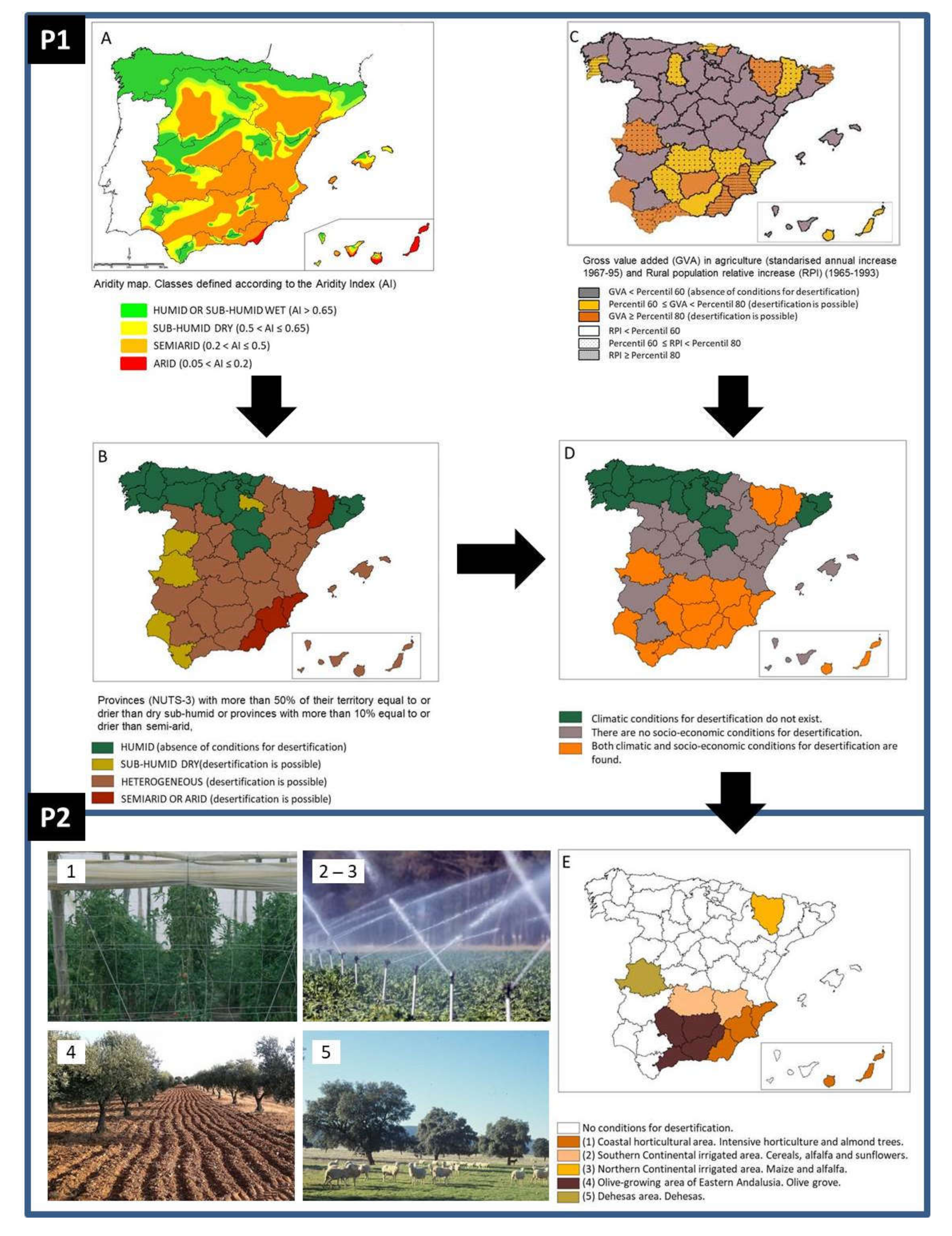
The method designed in SURMODES, outlined in Figure 1, consists of two procedures based both on climate and socio-economic risks. The first procedure (P1) produced a map of potential desertification, while the second (P2) used this map to identify socio-economic syndromes within provinces where desertification was developing. SURMODES works at the provincial level (i.e., small regions with populations between 150,000 and 800,000 inhabitants). Since several aridity zones can occur in each province (Figure 1A), only those with more than one half of their extension belonging to the dry sub-humid, semi-arid or arid classes were included (Figure 1B). The economic conditions risking desertification were then reflected through (i) the normalized annual increase in gross value added in agriculture for the period 1967–1995; and (ii) the relative annual increase in the rural population for the period 1965–1993 (Figure 1C). The intersection of climate and economic conditions yielded the potential desertification map (Figure 1D), where the provinces with both climatic and socio-economic conditions for desertification were identified. P2 looked at agricultural land uses that had undergone fast growth in the reference period (1967–1993). Data were obtained from the National Institute of Statistics (www.inebase.es (accessed on 10 January 2022). The expansion of cropland was used as a proxy variable of a potential threat of land degradation [20,21,22]. The provinces where the increase in surface was due to only one or two land uses, which also were consumers of limited resources in drylands (water, soil, fodder, etc.), were prime candidates for active desertification. The territorial expression of such dynamics converged to five desertification syndromes: (i) coastal irrigated agriculture; (ii) southern continental irrigated agriculture; (iii) northern irrigated agriculture; (iv) olive orchards in eastern Andalusia; and (v) dehesas, a savannah-like formation of permanent grasslands with disperse holm oak cover in the west of mainland Spain (Figure 1E). Additional information obtained from technical and governmental documentation, and from field surveys, which included mainly on-spot interviews with farmers and technical experts, was used to confirm the hotspots detected by SURMODES.
Only one of the scenarios described above is related to livestock (dehesas). At the time these maps were drawn up, it was striking that this use appeared to be related to desertification, as this agro-silvo-pastoral use has always been considered a paradigm of sustainability [23]. However, erosion processes linked to the increase in stocking density [24] occurred over recent decades in these ecosystems, which have been associated with the enormous increase in grazing livestock promoted by the incentives of the EU Common Agricultural Policy [25]. Other scenarios include the expansion of olive groves in Andalusia and the associated erosion problems, and irrigated agriculture. This later case shows two variants: (a) herbaceous crops including non-food crops (alfalfa and corn) related to soil salinisation in the north of Spain [26] and irrigated land in La Mancha (central Spain), linked to the overexploitation of important regional aquifers [27]; and (b) the Mediterranean coastal strip of southeastern Spain, which includes the provinces of Alicante, Murcia, and Almeria. High-yielding horticultural crops (e.g., greenhouses) have thrived there (see Valera et al. [28] for a review), causing the deterioration of numerous aquifers [29,30].
3. The Consequences of Ignoring an Accurate Diagnosis
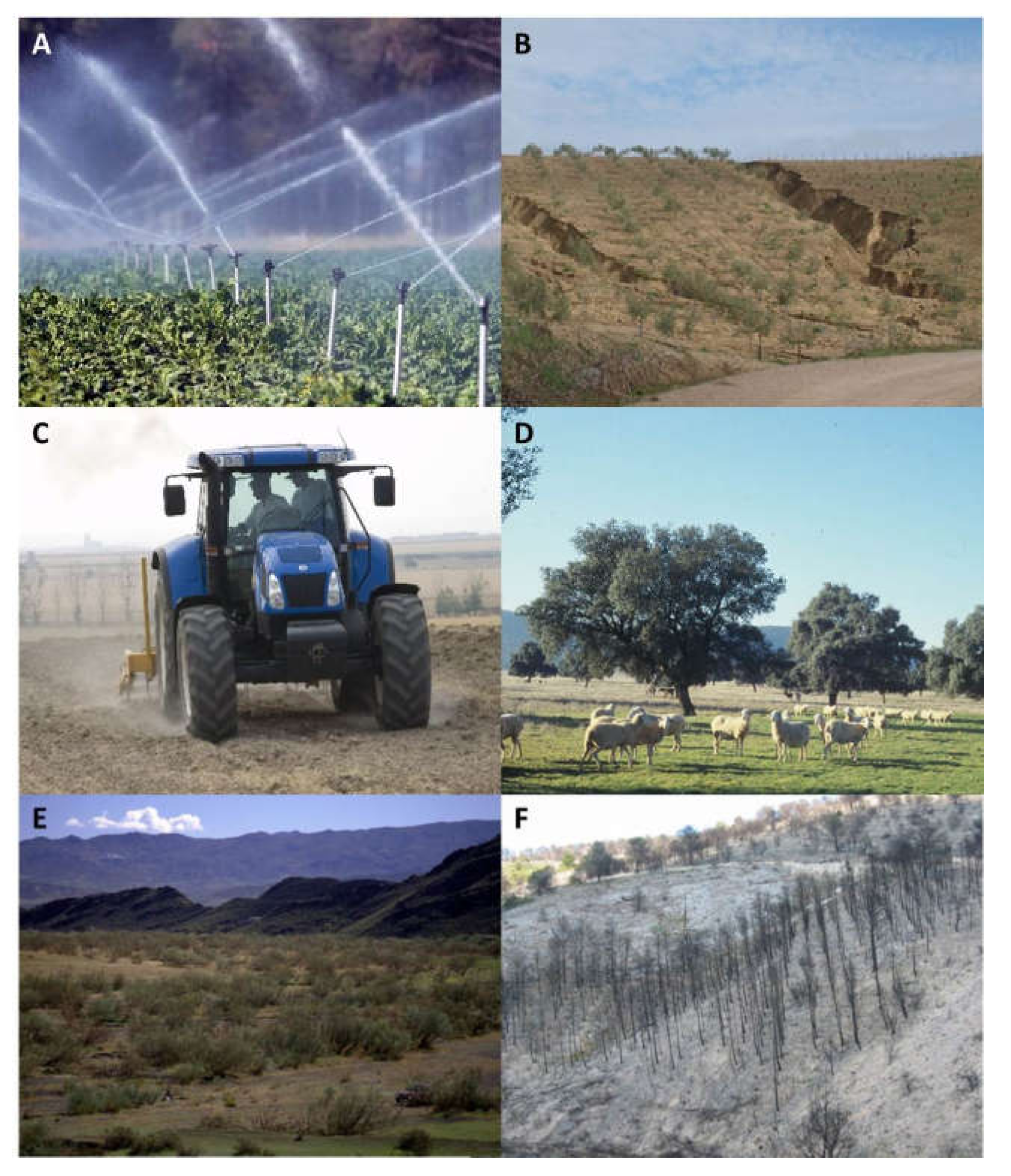
SURMODES hotspots were the basis of the “desertification landscapes” included in the PAND-2008 (Figure 2). Under this new designation, PAND-2008 included a collection of syndromes mentioning drivers, land uses, environmental impacts, and areas that were or could be potentially affected. It is worthy to note the lack of a cartographic expression of desertification landscapes in the PAND-2008, which only points out their geographic location, in a somewhat generic way in some cases, but did not accurately map them. The three hotspots related to irrigation detected by SURMODES were grouped under “Irrigated areas with desertification risk” landscape. The hotspot related to erosion and olive groves was extended to include “Woody crops affected by erosion” and “Rainfed herbaceous crops with erosion risk”. Finally, dehesas were generalized to “Overgrazed agroforestry pastoral systems”. The PAND-2008 also included a landscape related to relict desertification (“Degraded shrublands and wastelands”), which encompasses a wide range of land uses and land covers. These areas cover about 2 Mha in Spain and nowadays support formations of wasteland or scrubland resulting from the degradation of more mature vegetation formations [15] driven by human actions carried out in the past (e.g., mining and abandonment of agricultural terraces or deforestation).
SURMODES was a methodology implemented within the PAND-2008, but it was not the PAND-2008 itself. As an academic exercise, it anticipated the nonsense of accurately mapping desertification scenarios, much in line with the later WAD. However, PAND-2008 was a political program, and it had to meet the (then) perceived need of conventional maps. Resulting from this clash, a desertification risk map, far from the philosophy implemented by SURMODES, was further developed within the PAND-2008. Specifically, this risk map represents an index that brings together a series of variables in a subjective way, ignoring the dynamic nature of desertification and the interaction between the different processes [2]. Moreover, the map is built on variables that reflect the impact of desertification (erosion and overexploitation of groundwater), and not on its drivers (irrigation expansion and food demand). In our opinion, it is at this point where PAND-2008 started to be undermined in becoming an effective tool to combat desertification. Instead of being a real action plan following the causes that give rise to desertification landscapes (i.e., curbing the threats that were starting to generate active desertification problems), the desertification strategy became a kind of “White paper on desertification” without any executive or binding character.
SURMODES was in line with the current desertification diagnosis procedure and was validated by the WAD. In fact, one of its case studies illustrated the progress of desertification in Spain [16]. Through a statistical analysis of land-condition trends and states [7], places where land degradation has occurred or is occurring are detected. Some agricultural ecosystems, which essentially coincide with those indicated in the diagnosis, exhibit clear signs of active degradation processes, which could drive them towards terminal states in which exhausted and unproductive systems are ultimately abandoned. Areas of increasing intensification, particularly where marginal lands are under irrigation, appear now as prominent land degradation hotspots. Twenty years on, desertification does not seem to have been adequately addressed in Spain. The first two decades of the 21st century have consolidated an agri-food model whose dynamics have exacerbated the land degradation processes that were detected at the end of the last century. The following points illustrate this trend:
(i) The Spanish primary sector has become marginal in terms of employment (3.8%) and GDP (2.6%) [32]. However, it is still a strategic sector that occupies a large part of the territory (23.8 Mha or 47% of the landscape, including cropland and pastures [33]). The Spanish agri-food model has undergone a series of changes as a result of the country’s modernization, rural exodus, and its entry into the European Economic Community [34,35]. The industrialization of agriculture has led to a significant increase in the biomass produced but, above all, to a concentration of the biomass extracted from primary crops, embodied by the specialization in the Spanish agrarian sector in livestock, fruit and vegetables, and olive oil production [34].
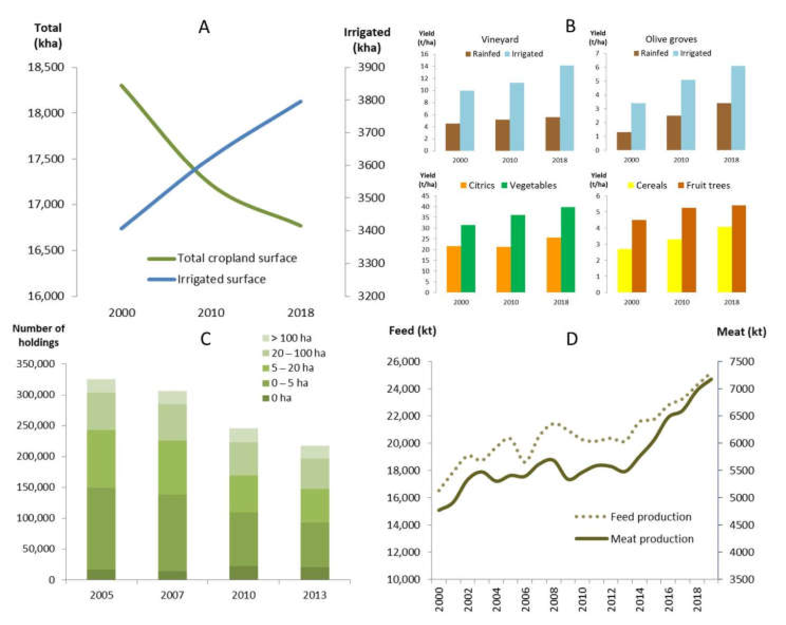
(ii) Over 2 Mha of cropland have been lost so far in the 21st century (Figure 3A), and livestock farming is now mainly carried out in industrial sheds [36,37]. Between 2005 and 2013, over 108,000 farms have been lost and the only category showing considerable growth (25%) is those without grazing land [38] (Figure 3C). Abandoned lands are at the mercy of various threats of degradation [39,40], as we will discuss below.
(iii) Yields per hectare have increased considerably due to the technification of the sector and the expansion of irrigation (Figure 3B). Irrigated areas have increased by 86% during the period 1960–2000, i.e., 1.57 Mha [42]. The tendency, although with smaller increases (12% during the period 2000–2019), has continued upwards in recent years, reaching 3.82 Mha in 2019 [42] (Figure 3A). In terms of livestock farming, Spain is immersed in the so-called livestock revolution [43]. In general, animal production is decoupled from the environment due to the process of livestock intensification that has occurred over the last decades in Spain [38]. Consequently, overgrazing and erosion-related processes have vanished. The rapid process of livestock stabling and the widespread use of animal feed is behind land re-greening in 30% of the territory [6]. This leads, however, to the creation of more vulnerable landscapes to wildfires [19,44]. Spain has become the leading feed producer in the EU [45], and its meat production continues to grow (Figure 3D). The general improvement in land condition and the huge import of soya used in the manufacture of animal feed [38] can be interpreted as a transfer of the degradation to those regions that produce the raw materials.
(iv) Relocation of agricultural production from the humid north to the (semi-)arid south [39,40,41]. Technological development (use of groundwater and other hydraulic infrastructures) has eliminated water restrictions typical of drylands, and this has allowed the use of more favourable thermal conditions for enhancing crop production. This has decoupled areas of current high agricultural productivity from those with better natural resource provision, leading to a large dryland area that is regularly irrigated.
(v) One third of all irrigated land in the European Union is located in Spain [46]. Many irrigation schemes in Spain are focused on productivity (irrigation, with only 14% of the agricultural area, generates 60% of the total agricultural production [46] and uses 65% of available water resources [47]) and are associated with the decline and deterioration of groundwater bodies and their associated ecosystems [18,31,48,49,50]. Between 2000 and 2016, groundwater use in Spanish agriculture has increased from 4.08% to 22.4% [51], which means that 73% of groundwater—about 7 hm3 per year—is used by agriculture [52]. Groundwater bodies have continued to degrade due to the constant increase in irrigation surface [31,48,53], threatening adjacent ecosystems, including emblematic national parks such as Doñana and Tablas de Daimiel [54,55].
(vi) The level of food consumption has risen, and to cover the gap between demand and supply more food, or the raw materials to produce it, it is being imported. The proportion of domestic land used within the territory of a country compared with land used outside a country’s territory is 37–63% in Spain [56]. In other words, Spain has become a net importer of biomass, going from 773 kt in 1900 to 31,929 kt in 2008, with 42% going to animal feed [34].
4. Perspectives under a New PAND
It seems that the interest in desertification is raising in Spain, and proof of this is the commitment of the Spanish Government to develop a new PAND. This promising opportunity may reaffirm the successes of the past and amend the mistakes that prevented halting the progress of desertification in Spain. The first step is to update the desertification diagnosis to detect the current desertification landscapes. We must not lose sight of the fact that the most recent data of the previous diagnosis date back to 1993. Since then, some trends have deepened (global warming and depopulation of Spanish rural areas), and new threats have emerged (growth in the number of industrial farms, irrigation of traditionally rainfed woody species, and increased demand for fruit and vegetable products, to name a few). The SURMODES structure is still valid, but it is necessary to include new variables (e.g., groundwater condition, crop prices, and energy and water requirements per crop type) that capture the current desertification drivers. For example, it makes little sense to link desertification to population density since agriculture is highly mechanized and tends to occupy sparsely populated areas. Today, the pressure on land arises from the demand for food from markets that may be thousands of kilometres away from production sites.
Although diagnoses are essential to delimit a problem and know its magnitude, no matter how good and technically sophisticated they may be, if they do not lead to proposals or solutions, they are useless [59]. The new PAND must be substantiated around the drivers behind the landscapes, understanding their raison d’être and the stakeholders and policies involved. This analysis points to the design of preventive actions, although mitigation actions should also play an important role. The latter should aim at restoring already desertified lands that are part of the “Degraded shrublands and wastelands” landscape and occupy 20% of the territory [6]. However, the former is more complex, since they come up against enormous obstacles. Indeed, development plans such as irrigation [60] have broad social and political support and are behind the economic growth of regions historically resigned to a modest standard of living. At the same time, these initiatives set in motion degradation mechanisms that threaten their very survival in the medium and long term.
What is really at stake is the short-term vision of land management, which seeks to maximize the flow of primary productivity of ecosystems [61] to the detriment of a vision that fully contemplates and values natural capital. The conflict is ethical in scope and the transition to a more sustainable world, in which individual well-being increases and humanity prospers rather than survives, requires a shift away from current economic measures [62]. We are trapped in a decision-making system in which immediacy is paramount. The political cost of dismantling or threatening a process of economic growth is very high. Jean-Claude Juncker, former president of Eurogroup, delivered a lapidary phrase when talking about economic reforms: “We all know what to do, but we don’t know how to get re-elected once we have done it.” [63]. This is the tragedy of desertification. Nobody wants to confront it while it is occurring because many of its drivers support economic growth that make all actors involved (politicians, stakeholders, farmers and, in general, the population of the area) reluctant to take this problem seriously. The fact that this growth may not be sustainable is not a sufficient argument to stop the dynamics of overexploitation of natural resources. It is impossible to reconcile agriculture and the environment without effective coordination of the different policies and administrations involved. Desertification is, for example, the deterioration of an aquifer, but it is also the fact that the population is impoverished because it cannot exploit groundwater once this happens. Therefore, solutions fall somewhere between the unbridled use of resources and their total conservation.
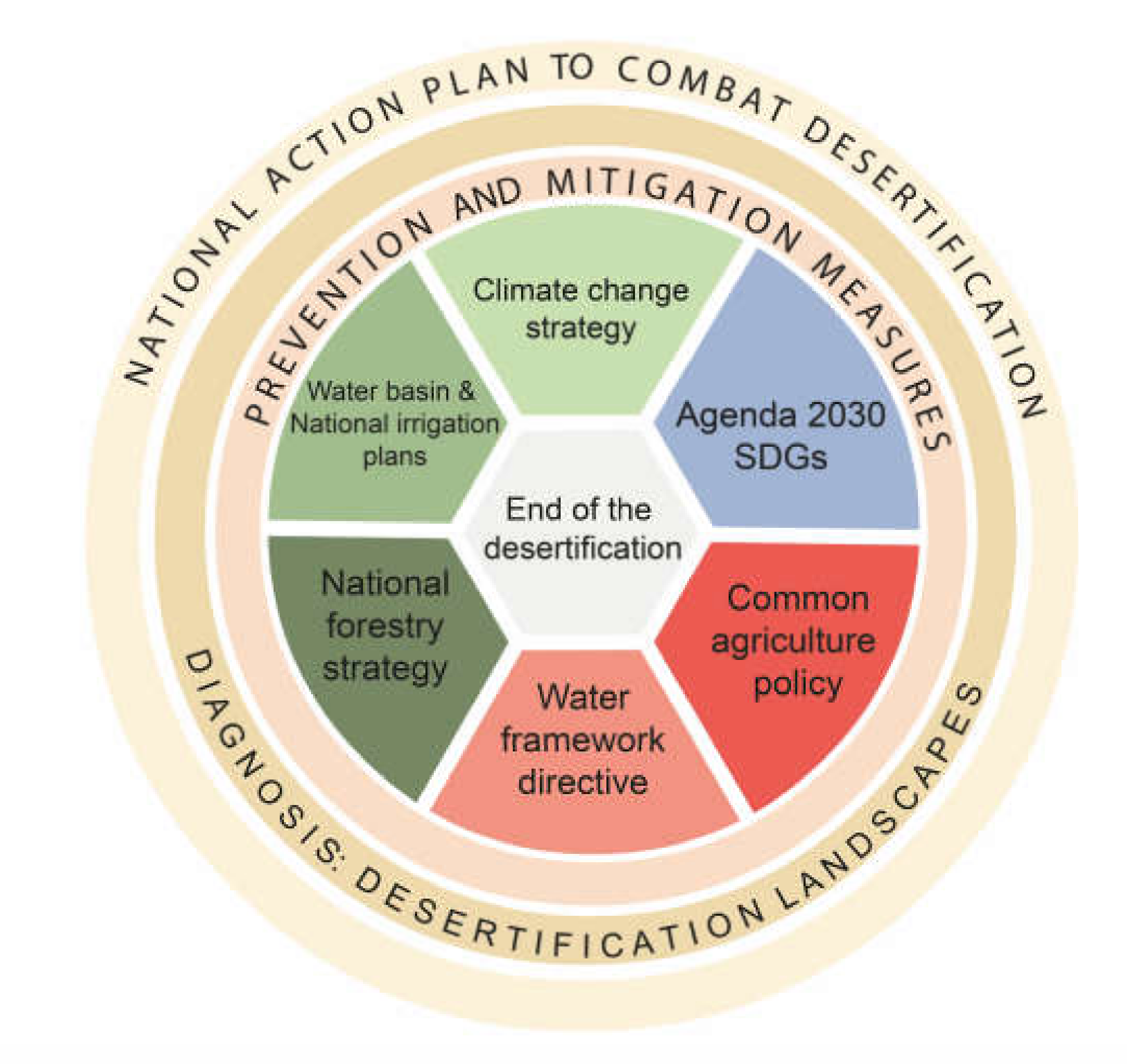
A plan that addresses desertification must manage the conflicting environmental and developmental expectations that co-exist in the United Nations Convention to Combat Desertification [64], and should integrate varied aspects of society. The new PAND should coordinate, as far as possible, the different sectoral policies that, in one way or another, are related to desertification. Figure 4 shows some of them, such as policies related to water, forestry management, agriculture, or the Agenda 2030 that monitors the status and achievements of the Sustainable Development Goals (SDGs) [65]. However, there are many others, such as the Plan of Measures to Meet the Demographic Challenge, aimed at combating depopulation and guaranteeing social and territorial cohesion in Spain [66], or regional rural development programs to promote complementary activities or activities other than agriculture [67]. The challenge is substantial because it is necessary to align commitments and strategies operating at various spatial scales. In an increasingly globalized world, many factors interact favouring and disfavouring sustainable development, and go beyond local and national contexts [68]. The transversal character of SDGs, their interlinkages [69], synergies, and contradictions [70] form an example that illustrates the need for a governance scheme to guide the PAND construction process. The identification of trade-offs and priority actions require the integration of environmental policy considerations into core institutional thinking with other policies and related activities, as well as with coordination and harmonization to ensure policy coherence [71].
5. Conclusions
Spain tackled the diagnosis of desertification in a very precise manner, developing more than 10 years ago a methodology similar to the convergence of evidence being proposed by the WAD as a new paradigm to study and combat desertification. Unfortunately, the diagnosis was not followed by a plan that adequately addressed the problem. Consequently, the potential desertification landscapes that were correctly detected have evolved into territories that have lost part of their valuable natural resources, such as fertile soil and groundwater. The situation detected in 2000 has worsened due to the deepening of global warming, the intensification of agriculture, or the territorial imbalance between rural/urban and inland/coastal areas. These drivers are entrenching old desertification landscapes and generating new ones.
The Spanish government’s declaration of climate emergency has launched a series of priority objectives, including the development of a new strategy to combat desertification. The new PAND is an excellent opportunity to (i) update desertification landscapes with a methodology that has already proven its worth as it coincides with the most cutting-edge concept of desertification diagnosis; and (ii) design a set of measures consistent with the diagnosis. In addition, this plan should coordinate a common front that encompasses the various initiatives related to desertification scattered in different local, regional, national, and European policies and programs.
Author Contributions
Conceptualization, J.M.-V.; formal analysis, J.M.-V.; G.d.B. and M.E.S. methodology, G.d.B. and M.E.S.; investigation, All authors.; methodology, G.d.B. and M.E.S.; Project administration, F.T.M. writing—original draft preparation, J.M.-V.; writing—review and editing, All authors.; visualization, J.M.-V. and E.G.; supervision, J.M.-V., G.d.B. and F.T.M.; funding acquisition, F.T.M. All authors have read and agreed to the published version of the manuscript.
Funding
This research was funded by the European Research Council (ERC Grant agreement 647038 [BIODESERT]) and Generalitat Valenciana (CIDEGENT/2018/041). Emilio Guirado is funded by the Consellería de Educación, Cultura y Deporte de la Generalitat Valenciana, and the European Social Fund in the call [APOSTD/2021/188].
Data Availability Statement
The data used have been appropriately cited. Those official databases are open-access.
Conflicts of Interest
The authors declare no conflict of interest.
References
- Gobierno de España. Acuerdo de Consejo de Ministros por el que se Aprueba la Declaración del Gobierno ante la Emergencia Climática y Ambiental; Gobierno de España: Madrid, Spain, 2020; Available online: https://www.miteco.gob.es/es/prensa/declaracionemergenciaclimatica_tcm30-506551.pdf (accessed on 10 January 2022).
- Prince, S.D. Where does desertification occur? Mapping dryland degradation at regional to global scales. In The End of Desertification? Disputing Environmental Change in the Drylands; Behnke, R., Mortimore, M., Eds.; Springer: Berlin/Heidelberg, Germany, 2016; pp. 225–263. ISBN 978-3-642-16013-4. [Google Scholar]
- Zdruli, P.; Cherlet, M.; Zucca, C. Desertification: Mapping constraints and challenges. In Encyclopedia of Soil Science, 3rd ed.; CRC Press: Boca Raton, FL, USA, 2016; pp. 633–641. ISBN 978-1498738903. [Google Scholar]
- Gibbs, H.K.; Salmon, J.M. Mapping the world’s degraded lands. Appl. Geogr. 2015, 57, 12–21. [Google Scholar] [CrossRef]
- Alias, L.; Ortiz, R. Memorias y Mapas de Suelos de las Hojas del MTN a escala 1:50.000; Proyecto LUCDEME 1986–2004; Ministerio de Medio Ambiente: Madrid, Spain, 1986.
- Sanjuán, M.E.; del Barrio, G.; Ruiz, A.; Rojo, L.; Puigdefábregas, J.; Martínez, A. Evaluación y Seguimiento de la Desertificación en España: Mapa de la Condición de la Tierra 2000–2010; Ministerio de Agricultura, Alimentación y Medio Ambiente (España): Madrid, Spain, 2014; ISBN 978-84-491-1395-6.
- Del Barrio, G.; Puigdefabregas, J.; Sanjuan, M.E.; Stellmes, M.; Ruiz, A. Assessment and monitoring of land condition in the Iberian Peninsula, 1989–2000. Remote Sens. Environ. 2010, 114, 1817–1832. [Google Scholar] [CrossRef]
- Verón, S.R.; Paruelo, J.M.; Oesterheld, M. Assessing desertification. J. Arid Environ. 2006, 66, 751–763. [Google Scholar] [CrossRef]
- Ferrara, A.; Kosmas, C.; Salvati, L.; Padula, A.; Mancino, G.; Nolè, A. Updating the MEDALUS-ESA Framework for Worldwide Land Degradation and Desertification Assessment. Land Degrad. Dev. 2020, 31, 1593–1607. [Google Scholar] [CrossRef]
- Cherlet, M.; Hutchinson, C.; Reynolds, J.; Hill, J.; Sommer, S.; von Maltitz, G. (Eds.) World Atlas of Desertification; Publication Office of the European Union: Luxembourg, 2018; ISBN 978-92-79-75350-3. [Google Scholar]
- Behnke, R.H.; Mortimore, M. Introduction. In The End of Desertification? Disputing Environmental Change in the Drylands; Behnke, R., Mortimore, M., Eds.; Springer: Berlin/Heidelberg, Germany, 2016; pp. 1–34. ISBN 978-3-642-16013-4. [Google Scholar]
- Becerril-Piña, R.; Mastachi-Loza, C.A. Desertification: Causes and countermeasures. In Life on Land. Encyclopedia of the UN Sustainable Development Goals; Leal Filho, W., Azul, A.M., Brandli, L., Lange Salvia, A., Wall, T., Eds.; Springer: Cham, Switzerland, 2021; pp. 219–231. ISBN 978-3319959801. [Google Scholar]
- Reynolds, J.F. Desertification is a prisoner of history: An essay on why ecologists should care. Ecosistemas 2021, 30, 2302. [Google Scholar] [CrossRef]
- Puigdefábregas, J.; del Barrio, G. SURMODES: A Surveillance System for Assessing and Monitoring of Desertification. 2000. Available online: http://www.eeza.csic.es/surmodes/surmodes/welcome.htm (accessed on 10 January 2022).
- MAGRAMA. Programa de Acción Nacional Contra la Desertificación; Ministerio de Agricultura y Medio Ambiente: Madrid, Spain, 2008.
- Del Barrio, G.; Sanjuán, M.E.; Ruiz, A.; Martínez-Valderrama, J.; Puigdefábregas, J. Case study: Land condition surveillance using geospatial data (Iberian Peninsula and Maghreb). In World Atlas of Desertification; Cherlet, M., Hutchinson, C., Reynolds, J., Hill, J., Sommer, S., von Maltitz, G., Eds.; Publication Office of the European Union: Luxembourg, 2018; pp. 194–197. ISBN 978-92-79-75350-3. [Google Scholar]
- Puigdefábregas, J. Erosión y desertificación en España. Campo 1995, 132, 63–83. [Google Scholar]
- Martínez-Fernández, J.; Esteve, M.A. A critical view of the desertification debate in southeastern Spain. Land Degrad. Dev. 2005, 16, 529–539. [Google Scholar] [CrossRef]
- Puigdefábregas, J.; Mendizabal, T. Perspectives on desertification: Western Mediterranean. J. Arid Environ. 1998, 39, 209–224. [Google Scholar] [CrossRef]
- Geist, H.J.; Lambin, E.F. Dynamic Causal Patterns of Desertification. Bioscience 2004, 54, 817–829. [Google Scholar] [CrossRef] [Green Version]
- Reynolds, J.F.; Smith, D.M.S.; Lambin, E.F.; Turner, B.L., II; Mortimore, M.; Batterbury, S.P.J.; Downing, T.E.; Dowlatabadi, H.; Fernandez, R.J.; Herrick, J.E.; et al. Global Desertification: Building a Science for Dryland Development. Science 2007, 316, 847–851. [Google Scholar] [CrossRef] [PubMed] [Green Version]
- Geist, H. The Causes and Progression of Desertification; Routledge Taylor & Francis Group: London UK; New York, NY, USA, 2005; ISBN 9780754643234. [Google Scholar]
- Diaz, M.; Campos, P.; Pulido, F.J. The Spanish dehesas: A diversity in land-use and wildlife. Farming Birds Eur. 1997, 178, 209. [Google Scholar]
- Schnabel, S. Soil Erosion and Runoff Production in a Small Watershed under Silvo-Pastoral Landuse (Dehesas) in Extremadura, Spain; Geoforma Ediciones: Logroño, Spain, 1997. [Google Scholar]
- Ibáñez, J.; Martínez-Valderrama, J.; Schnabel, S. Desertification due to overgrazing in a dynamic commercial livestock-grass-soil system. Ecol. Modell. 2007, 205, 277–288. [Google Scholar] [CrossRef]
- Castañeda, C.; Herrero, J.; Latorre, B. The Vanishing Legacy of Soil Salinity Data from Irrigated Districts: A Case Study from Spain and a Call for Action, 1st ed.; Elsevier Inc.: Amsterdam, The Netherlands, 2020; Volume 161, ISBN 9780128207659. [Google Scholar]
- Martínez-Valderrama, J.; Ibañez, J.; Alcalá, F.J.; Dominguez, A.; Yassin, M.; Puigdefábregas, J. The use of a hydrological-economic model to assess sustainability in groundwater-dependent agriculture in drylands. J. Hydrol. 2011, 402, 80–91. [Google Scholar] [CrossRef]
- Valera, D.; Molina, D.; Belmonte, J.; López, A. Greenhouse Agriculture in Almeria. A Comprenhensive Techno-Economic Analysis; Cajamar: Almeria, Spain, 2016. [Google Scholar]
- Garcia-Caparros, P.; Contreras, J.I.; Baeza, R.; Segura, M.L.; Lao, M.T. Integral management of irrigation water in intensive horticultural systems of Almería. Sustainability 2017, 9, 2271. [Google Scholar] [CrossRef] [Green Version]
- Foster, S.; Custodio, E. Groundwater Resources and Intensive Agriculture in Europe—Can Regulatory Agencies Cope with the Threat to Sustainability? Water Resour. Manag. 2019, 33, 2139–2151. [Google Scholar] [CrossRef]
- Custodio, E.; Andreu-Rodes, J.M.; Aragón, R.; Estrela, T.; Ferrer, J.; García-Aróstegui, J.L.; Manzano, M.; Rodríguez-Hernández, L.; Sahuquillo, A.; del Villar, A. Groundwater intensive use and mining in south-eastern peninsular Spain: Hydrogeological, economic and social aspects. Sci. Total Environ. 2016, 559, 302–316. [Google Scholar] [CrossRef] [PubMed] [Green Version]
- Instituto Nacional de Estadística. Contabilidad Nacional Anual de España: Agregados por Rama de Actividad. Available online: https://www.ine.es/dyngs/INEbase/es/operacion.htm?c=Estadistica_C&cid=1254736177056&menu=resultados&idp=1254735576581 (accessed on 10 January 2022).
- Ministerio de Agricultura Pesca y Alimentación. Anuario de Estadística Agroalimentaria. Available online: https://www.mapa.gob.es/estadistica/pags/anuario/2019/CAPITULOSPDF/CAPITULO07/pdfc07_4.11.1.pdf (accessed on 10 January 2022).
- Soto, D.; Infante-Amate, J.; Guzmán, G.I.; Cid, A.; Aguilera, E.; García, R.; González de Molina, M. The social metabolism of biomass in Spain, 1900–2008: From food to feed-oriented changes in the agro-ecosystems. Ecol. Econ. 2016, 128, 130–138. [Google Scholar] [CrossRef]
- Hill, J.; Stellmes, M.; Udelhoven, T.; Röder, A.; Sommer, S. Mediterranean desertification and land degradation: Mapping related land use change syndromes based on satellite observations. Glob. Planet. Chang. 2008, 64, 146–157. [Google Scholar] [CrossRef]
- Peláez, M. Fiebre por las ‘Macrogranjas’ Porcinas: 156 Abiertas en Cinco Años y 85 Proyectos en Estudio. Diario de Castilla y León, 19 July 2020. Available online: https://diariodecastillayleon.elmundo.es/articulo/castilla-y-leon/fiebre-macrogranjas-porcinas-156-abiertas-anos-85-proyectos-estudio/20200719144432013118.html (accessed on 10 January 2022).
- Delgado, A.; Tudela, A. El mapa de las macrogranjas de porcino en España. El Diario, 8 November 2021. [Google Scholar]
- Martínez-Valderrama, J.; Sanjuán, M.E.; Barrio, G.; Guirado, E.; Ruiz, A.; Maestre, F.T. Mediterranean Landscape Re-Greening at the Expense of South American Agricultural Expansion. Land 2021, 10, 204. [Google Scholar] [CrossRef]
- Van Leeuwen, C.C.E.; Cammeraat, E.L.H.; de Vente, J.; Boix-Fayos, C. The evolution of soil conservation policies targeting land abandonment and soil erosion in Spain: A review. Land Use Policy 2019, 83, 174–186. [Google Scholar] [CrossRef]
- García-Ruiz, J.M.; Lana-Renault, N. Hydrological and erosive consequences of farmland abandonment in Europe, with special reference to the Mediterranean region—A review. Agric. Ecosyst. Environ. 2011, 140, 317–338. [Google Scholar] [CrossRef]
- Alonso-Sarría, F.; Martínez-Hernández, C.; Romero-Díaz, A.; Cánovas-García, F.; Gomariz-Castillo, F. Main Environmental Features Leading to Recent Land Abandonment in Murcia Region (Southeast Spain). Land Degrad. Dev. 2016, 27, 654–670. [Google Scholar] [CrossRef]
- Ministerio de Agricultura Pesca y Alimentación. Anuario de Estadística Agroalimentaria (1904–2020); Ministerio de Agricultura Pesca y Alimentación: Madrid, Spain, 2020. Available online: https://www.mapa.gob.es/es/estadistica/temas/publicaciones/anuario-de-estadistica/default.aspx (accessed on 10 January 2022).
- Delgado, C.; Rosegrant, M.W.; Steinfeld, H.; Ehui, S.; Courbois, C. The Coming Livestock Revolution; Background Paper N. 6; Food and Agriculture Organization: Rome, Italy, 1999. [Google Scholar]
- Santana, V.M.; Baeza, M.J.; Marrs, R.H.; Vallejo, V.R. Old-field secondary succession in SE Spain: Can fire divert it? Plant Ecol. 2010, 211, 337–349. [Google Scholar] [CrossRef]
- European Feed Manufacturers’ Federation (FEFAC). Compound Feed Production (1989–2019); European Feed Manufacturers’ Federation: Brussels, Belgium, 2018. [Google Scholar]
- López-Gunn, E.; Mayor, B.; Dumont, A. Implications of the modernization of irrigation systems. In Water, Agriculture and the Environment in Spain: Can We Square the Circle? Llamas, M.R., de Stefano, L., Eds.; Fundación Botín; CRC Press: Boca Raton, FL, USA, 2012; pp. 241–255. ISBN 9780203096123. [Google Scholar]
- FAO (Food and Agriculture Organization of the United Nations). AQUASTAT Main Database. Available online: http://www.fao.org/aquastat/en/ (accessed on 24 February 2021).
- Hernández-Mora, N.; Martínez Cortina, L.; Llamas, R.; Custodio, E. Groundwater Issues in Southern EU Member States; Spain Country Report. In Groundwater in the Southern Member States of the European Union: An Assessment of Current Knowledge and Future Prospects; European Academies Science Advisory Council: Halle, Germany, 2007. [Google Scholar]
- Murillo, J.M.; Vega, L. Groundwater and protected natural areas in Spain. The hydrogeological characterization of national parks. Bol. Geol. Min. 2019, 130, 549–592. [Google Scholar] [CrossRef]
- Custodio, E.; Sahuquillo, A.; Albiac, J. Sustainability of intensive groundwater development: Experience in Spain. Sustain. Water Resour. Manag. 2019, 5, 11–26. [Google Scholar] [CrossRef]
- Hernández, M.; Morote, A.F. Evolución de los sistemas agrarios mediterráneos intensivos. Uso del agua y de la tierra (2000–2016). In El Regadío en el Mediterráneo Español. Una Aproximación Multidimensional; Garrido, A., Pérez-Pastor, A., Eds.; Cajamar: Almería, Spain, 2019; pp. 35–75. [Google Scholar]
- De Stefano, L.; Martínez-Cortina, L.; Chico, D. An overview of groundwater resources in Spain. In Water, Agriculture and the Environment in Spain: Can We Square the Circle? Llamas, R., De Stefano, L., Eds.; Fundación Botín; CRC Press: Boca Raton, FL, USA, 2012; pp. 87–104. ISBN 9780203096123. [Google Scholar]
- De Stefano, L.; Fornés, J.M.; López-Geta, J.A.; Villarroya, F. Groundwater use in Spain: An overview in light of the EU Water Framework Directive. Int. J. Water Resour. Dev. 2015, 31, 640–656. [Google Scholar] [CrossRef] [Green Version]
- Rodriguez, J.; De Stefano, L. Intensively Irrigated Agriculture in the North-West of Doñana. In Water, Agriculture and the Environment in Spain: Can We Square the Circle? Llamas, R., De Stefano, L., Eds.; Fundación Botín; CRC Press: Boca Raton, FL, USA, 2012; pp. 269–280. ISBN 978-0-415-63152-5. [Google Scholar]
- Esteban, E.; Albiac, J. The problem of sustainable groundwater management: The case of La Mancha aquifers, Spain. Hydrogeol. J. 2012, 20, 851–863. [Google Scholar] [CrossRef]
- Yu, Y.; Feng, K.; Hubacek, K. Tele-connecting local consumption to global land use. Glob. Environ. Chang. 2013, 23, 1178–1186. [Google Scholar] [CrossRef]
- European Commission Eurostat. Agriculture. Farm Structure. Available online: https://appsso.eurostat.ec.europa.eu/nui/show.do?dataset=ef_olsaareg&lang=en (accessed on 6 September 2020).
- European Commission Eurostat. Animal Production. Available online: https://ec.europa.eu/eurostat/web/agriculture/data/database?p_p_id=NavTreeportletprod_WAR_NavTreeportletprod_INSTANCE_ff6jlD0oti4U&p_p_lifecycle=0&p_p_state=normal&p_p_mode=view&p_p_col_id=column-2&p_p_col_count=1 (accessed on 7 September 2020).
- Folch, R.; Bru, J. Ambiente, Territorio y Paisaje; Editorial Barcino: Barcelona, Spain, 2017; ISBN 978-84-7226-819-7. [Google Scholar]
- De Stefano, L.; Lopez-Gunn, E. Unauthorized groundwater use: Institutional, social and ethical considerations. Water Policy 2012, 14, 147–160. [Google Scholar] [CrossRef] [Green Version]
- Del Barrio, G.; Martínez-Valderrama, J.; Ruiz, A.; Sanjuán, M.E.; Puigdefábregas, J. Land degradation means a loss of management options. J. Arid Environ. 2021, 189, 104502. [Google Scholar] [CrossRef]
- The Royal Society. People and the Planet; The Royal Society: London, UK, 2012. [Google Scholar]
- Juncker, J.-C. The Quest for Prosperity. The Economist, 17 March 2007; 1. [Google Scholar]
- Grainger, A. Is Land Degradation Neutrality Feasible in Dry Areas ? J. Arid Environ. 2015, 112, 14–24. [Google Scholar] [CrossRef]
- Ministerio de Asuntos Exteriores. Plan de Acción para la Implementación de la Agenda 2030 Hacia una Estrategia Española de Desarrollo Sostenible; Ministerio de Asuntos Exteriores: Madrid, Spain, 2015.
- Ministerio para la Transición Ecológica y el Reto Demográfico. Plan de Recuperación. 130 Medidas Frente al Reto Demográfico; Ministerio para la Transición Ecológica y el Reto Demográfico: Madrid, Spain, 2021.
- Ministerio de Hacienda. Programa Operativo Pluriregional de España 2014–2020; Ministerio de Hacienda: Madrid, Spain, 2014.
- Zortea, M.; Lucatello, S. Governing Drylands Through Environmental Mainstreaming: How to Cope with Natural Resources Scarcity and Climate Change. In Stewardship of Future Drylands and Climate Change in the Global South; Lucatello, S., Huber-Sannwald, E., Espejel, I., Martínez-Tagüeña, N., Eds.; Springer Climate; Springer Nature: Cham, Switzerland, 2020; pp. 337–350. [Google Scholar] [CrossRef]
- Zhou, X.; Moinuddin, M.; Xu, M. Sustainable Development Goals Interlinkages and Network Analysis: A Practical Tool for SDG Integration and Policy Coherence; Institute for Global Environemntal Strategies: Hayama, Japan, 2017. [Google Scholar]
- Vanham, D.; Alfieri, L.; Flörke, M.; Grimaldi, S.; Lorini, V.; De Roo, A.; Feyen, L. The number of people exposed to water stress in relation to how much water is reserved for the environment: A global modelling study. Lancet Planet. Health 2021, 5, 766–774. [Google Scholar] [CrossRef]
- Bass, S.; Roe, D.; Smith, J. Look Both Ways: Mainstreaming Biodiversity and Poverty Reduction; International Institute for Environment and Development: London, UK, 2010. [Google Scholar]
Figure 1.
Procedure for detecting desertification hotspots in Spain followed in the SURMODES approach. The desertification potential map (D) is the intersection of aridity conditions (A,B) and socio-economic conditions (C). The landscapes most prone to desertification (1–5 in bottom-left of the figure) are shown in panel (E). Source: SURMODES project [13,14]. Photographs taken from the photo library of CENEAM (National Centre for Environmental Education; https://www.miteco.gob.es/es/ceneam/centro-de-documentacion-ceneam/fototeca/default.aspx (accessed on 10 January 2022)).

Figure 2.
Desertification landscapes considered in the PAND-2008. (A) “Irrigated areas with desertification risk”. (B) “Woody crops affected by erosion”. (C) “Rainfed herbaceous crops with erosion risk”. (D) “Overgrazed agroforestry pastoral systems”. (E,F) “Degraded shrublands and wastelands”. Photo sources: (A,C,D,F): CENEAM; (B): José Alfonso Gómez; (E): Gabriel del Barrio.

Figure 3.
Evolution of variables showing the intensification of Spanish agriculture: (A) Decrease in agricultural area while irrigated area increases (2000–2018) [42]; (B) Yield increase for different crops (2000–2018) [42]; (C) Decrease in the number of farms with a relative increase in the number of farms with less than 5 ha (2005–2013) [57]; (D) Increasing feed and meat production (2000–2019) [45,58].

Figure 4.
Implementation of the new PAND. The diagnosis must be the envelope of the actions to be carried out, which are of two types: prevention and mitigation measures. The plan must be able to fit and coordinate the different policies related to desertification launched at national (green), European (red), and global (blue) scopes.

Publisher’s Note: MDPI stays neutral with regard to jurisdictional claims in published maps and institutional affiliations. |
© 2022 by the authors. Licensee MDPI, Basel, Switzerland. This article is an open access article distributed under the terms and conditions of the Creative Commons Attribution (CC BY) license (https://creativecommons.org/licenses/by/4.0/).
Share and Cite
MDPI and ACS Style
Martínez-Valderrama, J.; del Barrio, G.; Sanjuán, M.E.; Guirado, E.; Maestre, F.T. Desertification in Spain: A Sound Diagnosis without Solutions and New Scenarios. Land 2022, 11, 272. https://0-doi-org.brum.beds.ac.uk/10.3390/land11020272
AMA Style
Martínez-Valderrama J, del Barrio G, Sanjuán ME, Guirado E, Maestre FT. Desertification in Spain: A Sound Diagnosis without Solutions and New Scenarios. Land. 2022; 11(2):272. https://0-doi-org.brum.beds.ac.uk/10.3390/land11020272
Chicago/Turabian StyleMartínez-Valderrama, Jaime, Gabriel del Barrio, María E. Sanjuán, Emilio Guirado, and Fernando T. Maestre. 2022. "Desertification in Spain: A Sound Diagnosis without Solutions and New Scenarios" Land 11, no. 2: 272. https://0-doi-org.brum.beds.ac.uk/10.3390/land11020272
Note that from the first issue of 2016, this journal uses article numbers instead of page numbers. See further details here.