1. Introduction
As one of the most flexible land use types, cultivated land is an agricultural resource that guarantees human survival [
1]. It also constitutes an essential part of the rural landscape and is a primary carrier of agriculture civilization. With social and economic development, humans gradually develop great and diversified needs, and their understanding of the functions of cultivated land has gradually deepened; thus, each function of cultivated land is gradually manifested or developed [
2,
3]. The concept of multifunctionality originates from the agricultural sector and refers to the simultaneous provision of diverse goods or services [
4], and has now been extended to multiple fields. The multifunctionality of cultivated land is a single type of research under the framework of land multifunctional analysis, while land multifunctionality is theoretically based on ecosystem services and has evolved from research on agricultural multifunctionality and landscape multifunctionality [
5,
6,
7]. Therefore, the multifunctionality of cultivated land can be regarded as an extension of ecosystem function, agricultural multifunctionality, and landscape multifunctionality. As a semi-natural system, cultivated land is an ecosystem that relies on human alteration, and, similar to the farmland subsystem in the ecosystem, its multifunctionality stems from ecosystem service theory. Agricultural multifunctionality is the basis for the understanding and the existence of the multifunctionality of cultivated land [
8]. Landscape is composed of different homogeneous units, and cultivated land is clearly a homogeneous landscape that can achieve various social purposes and encompasses various functions [
9]. Considering the above research theories, the multifunctionality of cultivated land has been widely recognized and is of concern [
2,
8].
The division of cultivated land functions reflects the subjective will of human beings. The division methods of cultivated land functions vary according to the different research purposes and research areas. The multifunctionality of cultivated land is the product of the coupled development of human systems and natural systems [
10]. Its essence is to provide various products and services to meet human needs, including the intrinsic functions of the land and the functions generated by human use. The intrinsic functions of cultivated land are determined by its inherent attributes and are independent of human will. They can be regarded as the basic functions of cultivated land and divided into three categories: material production, ecological conservation, and landscape culture. First, cultivated land can nourish the growth and development of crops without the involvement of human labor and ultimately yields agricultural products. Second, cultivated land itself is a part of the ecosystem and has eco-environmental protection functions such as climate regulation and water conservation. Finally, cultivated land is the carrier of agriculture civilization, which, together with other rural landscapes, forms a landscape sequence with unique visual aesthetics. On the basis of the basic functions of cultivated land, humans use it for other purposes to meet diverse needs, resulting in the derivative functions of cultivated land, which can be seen as alternative manifestations of its basic functions [
11]. The food security function and the social security function emerge from the material production function [
10,
12]; the urban space barrier function come from the ecological conservation function [
13]; and the science popularization function and the leisure and entertainment function develop from the landscape culture function [
12]. The theoretical and analytical framework of ecosystem services has been widely accepted by scholars. If cultivated land and its closely related organisms and environment are regarded as an ecosystem, then the ecosystem services provided by the cultivated land ecosystem correspond to the basic functions of cultivated land, with the material production function corresponding to supply services, the ecological conservation function corresponding to support and regulation services, and the landscape culture function corresponding to cultural services [
8]. The value of the material production function of cultivated land can be reflected through the market transaction of agricultural products, while the functions of ecological conservation and landscape culture products and services can hardly be reflected through market transactions. Therefore, from the perspective of value quantification, the material production function can be concluded as the market function of cultivated land, and the ecological conservation and landscape culture functions are non-market functions. The derivative functions of cultivated land are the attachment and extension of the basic functions, and they have no physical form and their value can hardly be quantified through market transactions; thus, they are also the non-market functions of cultivated land.
With social development and changes in human needs, the leisure service function of cultivated land has stood out as being more important than the other non-productive functions [
14]. The cultivated land leisure service function can be seen as the function that relies on cultivated land, integrates the characteristics of the development of tourism service industry, and uses natural landscapes such as farmland and human landscapes such as agricultural production and agricultural culture to provide the public with sightseeing, cultural experience, and leisure. In the process of poverty alleviation and rural revitalization in China, the mode of agricultural experience and leisure tourism has been effective in increasing the income of rural households across the country, and this mode is also a clear manifestation of the cultivated land leisure service function. In 2021, the No. 1 Document by the CPC Central Committee proposed to comprehensively promote rural consumption and motivate urban residents to consume in the countryside. Major attractive factors include rural views, agricultural landscape, rural natural environment, agricultural products, and processed products, which are all closely related to the cultivated land leisure service function. Therefore, on the basis of ensuring the cultivated land grain production function, efforts should be exerted to respect the practical needs of human beings for the cultivated land leisure service function and provide support and guidance to implement cultivated land protection, promote rural economic development, and drive the realization of agricultural infrastructure modernization, rural living environment upgrade, and agricultural and rural development [
3]. At present, few studies focus solely on the cultivated land leisure service function and generally regard it as a non-productive function and incorporate it into the integrated study on the multifunctionality of cultivated land [
15]. However, the value of the leisure service function is an integral part of the non-market value of cultivated land [
16,
17] and is no less important than the value of its economic output [
18]. The perception of cultivated land leisure services is intangible and subjective; thus, the current methods for evaluating the non-market value of cultivated land are mainly divided into two categories: the stated preference method and the revealed preference method. The former includes the contingent valuation method (CVM) [
19,
20] and the selective experiment method (CE) [
21,
22,
23]; the latter includes the tourism cost method (TCM) [
24,
25], the hedonic pricing method (HPM) [
26,
27]. In addition, other methods measure the non-market value of cultivated land by referring to the functions of the market, such as the shadow project method [
28] and the opportunity cost method [
1]. The above methods evaluate cultural, educational, and leisure functions as a whole and thus fail to separate the leisure service functions and evaluate each individually.
With the development of information technology, a large amount of emerging spatial data has been used in the research of natural resources. Spatial data can reflect the spatial characteristics of cultivated land attributes and are relatively simple to acquire and more accurate and pertinent. Therefore, cultivated land leisure service function can be better evaluated separately realized through the use of spatial data. At present, few studies have used spatial data to analyze leisure services, and most existing studies use single-type spatial data, such as point of interest (POI) data [
29]. However, POI data are only a representation of the economy, which easily leads to the problem of incomplete and inadequate evaluation. Therefore, multisource spatial data should be selected from different dimensions to ensure a rigorous and accurate evaluation. This study evaluates the cultivated land leisure service function from the three dimensions of ecological landscape, social activities, and economic performance in an objective and comprehensive manner. According to the comprehensive evaluation results, suggestions on zoning optimization were put forward to promote the adjustment, management and optimization of cultivated land leisure services in the study area.
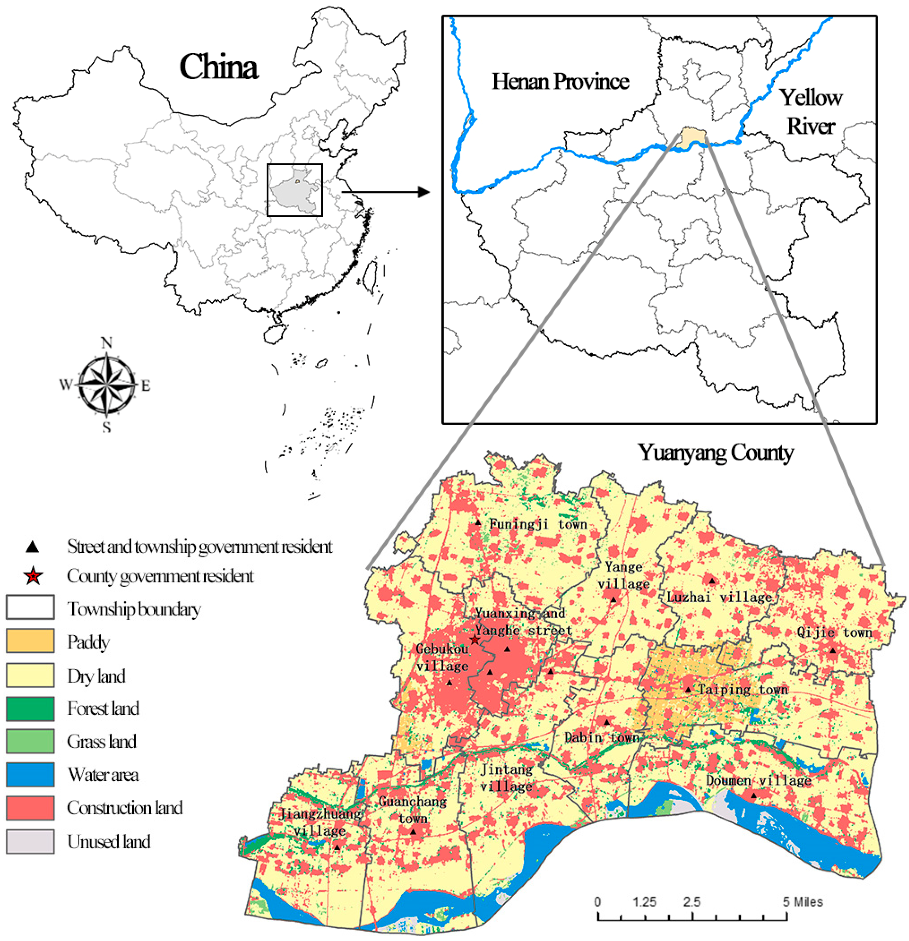
The Yellow River Basin is a critical ecological barrier and economic zone in China. Its ecological conservation and high-quality development are a major national strategy. An effective measure to coordinate high-quality development and ecological conservation is the implementation of ecological agriculture and leisure agriculture, the development of which depends largely on the cultivated land leisure service function. The back-river depressions along the Yellow River is a key area for the development of the Yellow River Basin, and cultivated land assumes the functions of agricultural production and economic development. Yuanyang County is located in the back-river depressions on the north side of the Yellow River and is an ideal place to develop a green leisure service economy as it is embraced by the original natural scenery along the river, which is steeped in history and culture, and well placed with convenient transportation. Therefore, taking Yuanyang as an example for the evaluation and improvement of the cultivated land leisure service function based on multisource spatial data can provide a theoretical analysis framework for similar studies and provide a reference for ecological conservation and economic development of cities and counties in the Yellow River Basin.
3. Results
3.1. Evaluation of Single Cultivated Land Leisure Service Function
3.1.1. Analysis of Landscape Pattern
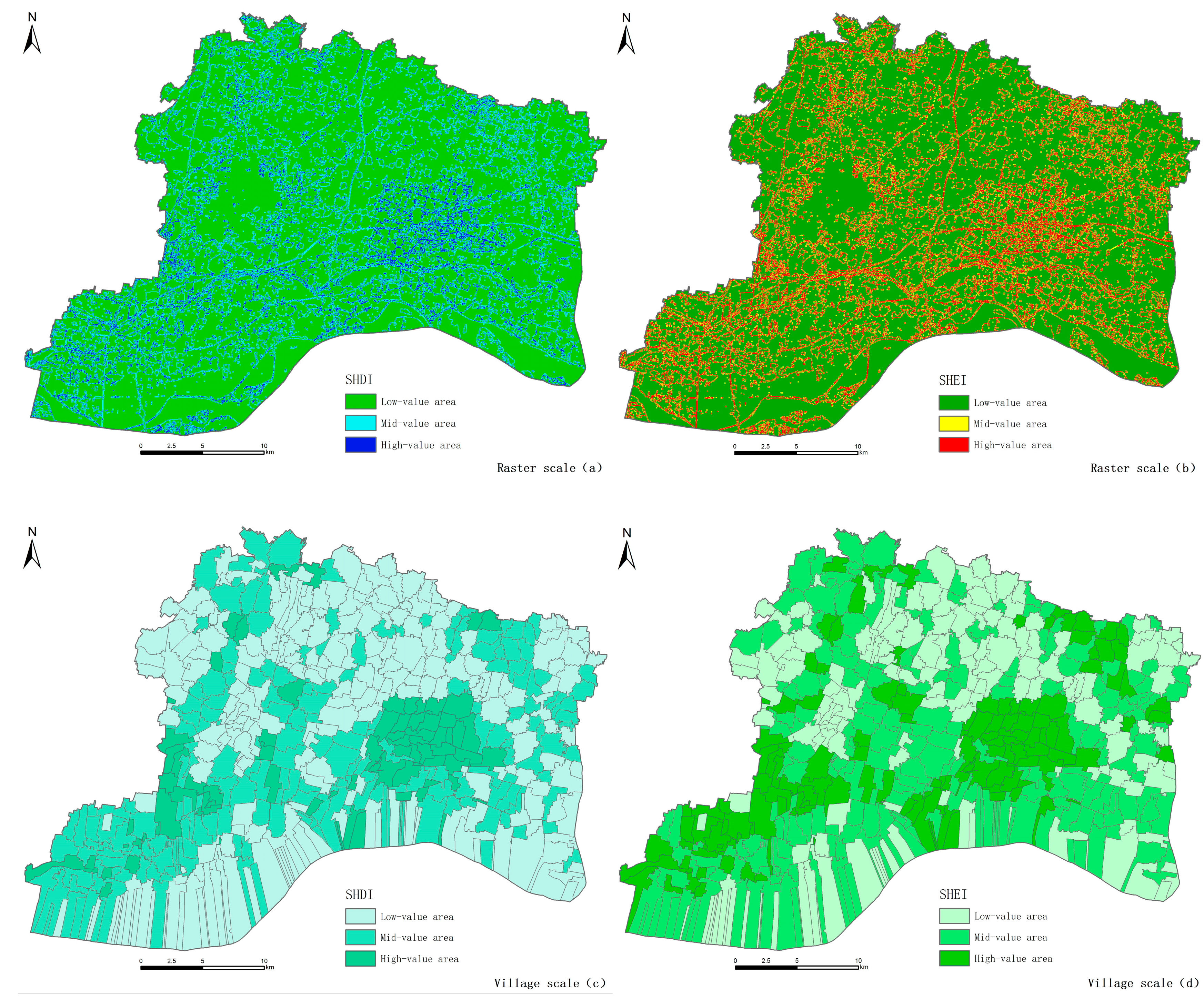
The cultivated land landscape is the original embodiment of the natural capital of cultivated land and the direct factor that attracts people to perceive leisure service. The good ecological landscape is a reflection of the high potential of cultivated land leisure services. In areas with good ecological landscapes, cultivated land leisure services and commodities are made and provided. SHDI represents the richness of landscape, while SHEI represents the balance of landscape; overall, their spatial distribution in Yuanyang County is similar with a few differences (
Figure 2). Areas at the raster scale with high SHDI values are mainly concentrated in the central and southern part of Yuanyang County, while SHEI is distributed evenly throughout the county. The distributions of SHDI and SHEI at the village scale are highly overlapping, with areas of higher values located in Jiangzhuang Village, Guanchang Town, Jintang Village, the northern part of Doumen Village, Gebukou Village, the southern part of Dabin Town, and Taiping Town, closely surrounding the ecological corridor of the Yellow River Embankment in terms of spatial distribution. As an emergency structure to prevent floods, the Yellow River Embankment is, most of the time, an ecological conservation belt with three-dimensional greening, which improves not only the diversity but also the evenness of landscapes and adds to the enjoyment of cultivated land in the region. As a tourist destination, Taiping Town features paddy fields as the dominant landscape element and other elements, including drylands, woodlands, water bodies, and construction land for homestays. The landscape has high diversity and richness, with cultivated land providing a great leisure and aesthetic function. Areas with median SHDI and SHEI values are next to areas with high values, mostly located in the central and southern parts, while areas with low values are mostly found along the Yellow River and in the northern part of Yang’e Village. The Yellow River beach consists mostly of sandy soils, and with the demand for river safety and ecological conservation, the surrounding area is protected from economic activities. Therefore, the landscape is dominated solely by cultivated land, and few landscape types are found in the northern part of Yang’e Village, a traditional dry farming area. In general, the landscape resources in the northern part are relatively monotonous, while the southern part features rich and evenly distributed landscape resources and has high potential for cultivated land leisure services.
3.1.2. Analysis of Spatial Accessibility
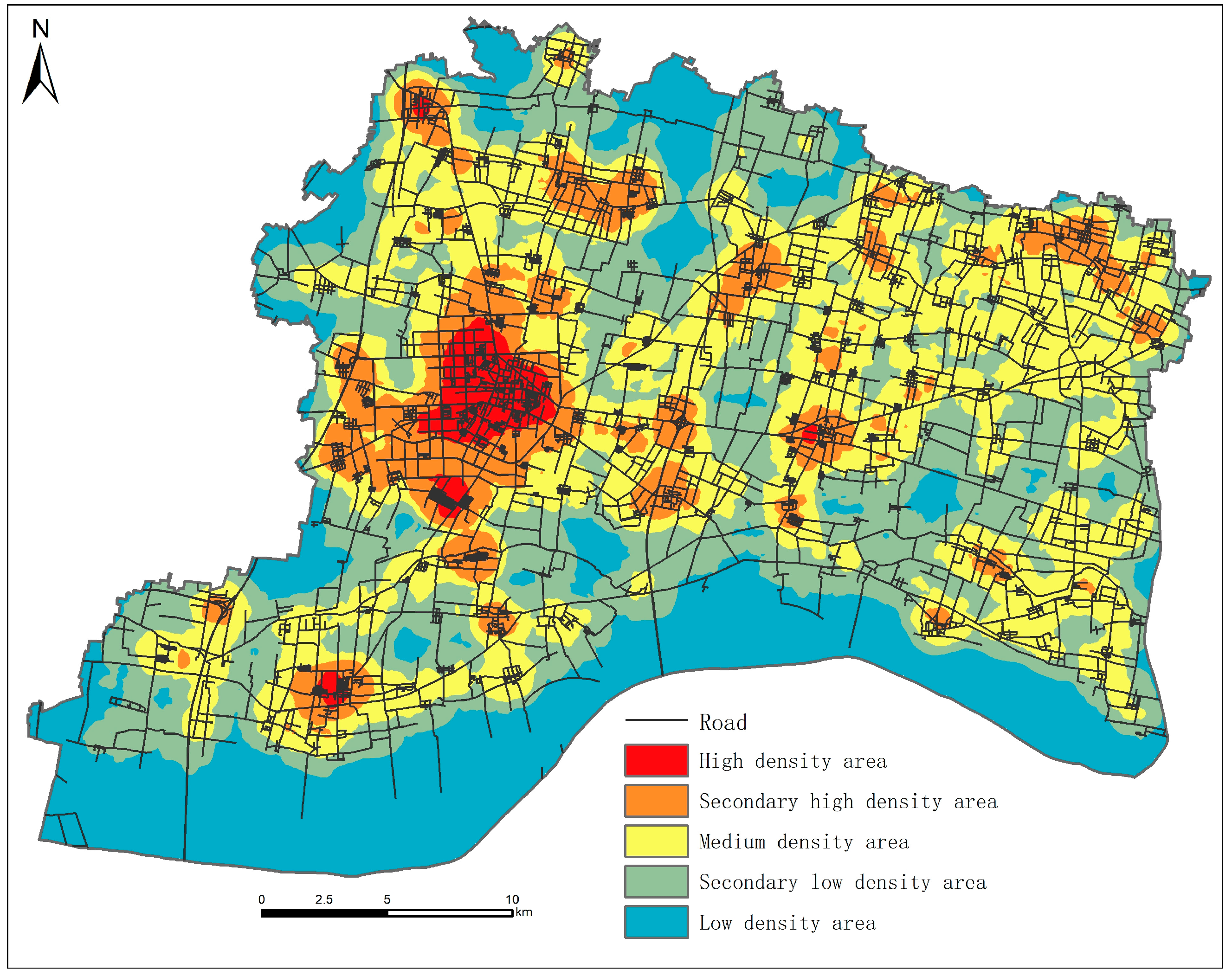
The density of road network in Yuanyang County shows clear spatial heterogeneity with large regional differences, presenting a spatial pattern of “one core with multiple subcores” (
Figure 3). The urban area consisting of Yuanxing and Yanghe residential districts and Gebukou Village has the highest spatial accessibility, indicating the great potential of the cultivated land leisure service function. As the county’s political, economic, and cultural center, this area is equipped with complete infrastructure and is the key area that drives and promotes the leisure service function of the cultivated land around the urban area, which has also been confirmed by the agglomeration of the large number of POIs related to cultivated land leisure service. A large number of sub-high-density areas formed by the road network were found, mostly in the urban area, and are scattered in each township with relatively poor connection. These areas are often accompanied by an agglomeration of cultivated land leisure service POIs, indicating that the improvement of road network has a significant impact on the effect of the cultivated land leisure service functions. Cultivated land resources are abundant and evenly distributed throughout Yuanyang County, which is why leisure service products based on cultivated land resources are ubiquitous. The large road network is conducive to the formation of multiple centers of the cultivated land leisure service function throughout the county, thus avoiding the overuse of cultivated land resources in a certain area. Most of the medium-density areas of the road network surround the sub-high-density areas. They are also areas where the radiation of the cultivated land leisure service function gradually diminishes. Low-density areas and sub-low-density areas connect with each other and have low potential for cultivated land leisure service function, and their role is to connect roads throughout the county to form a network that links the cultivated land leisure service function center of each area.
3.1.3. Analysis of Leisure Service Supply Capability
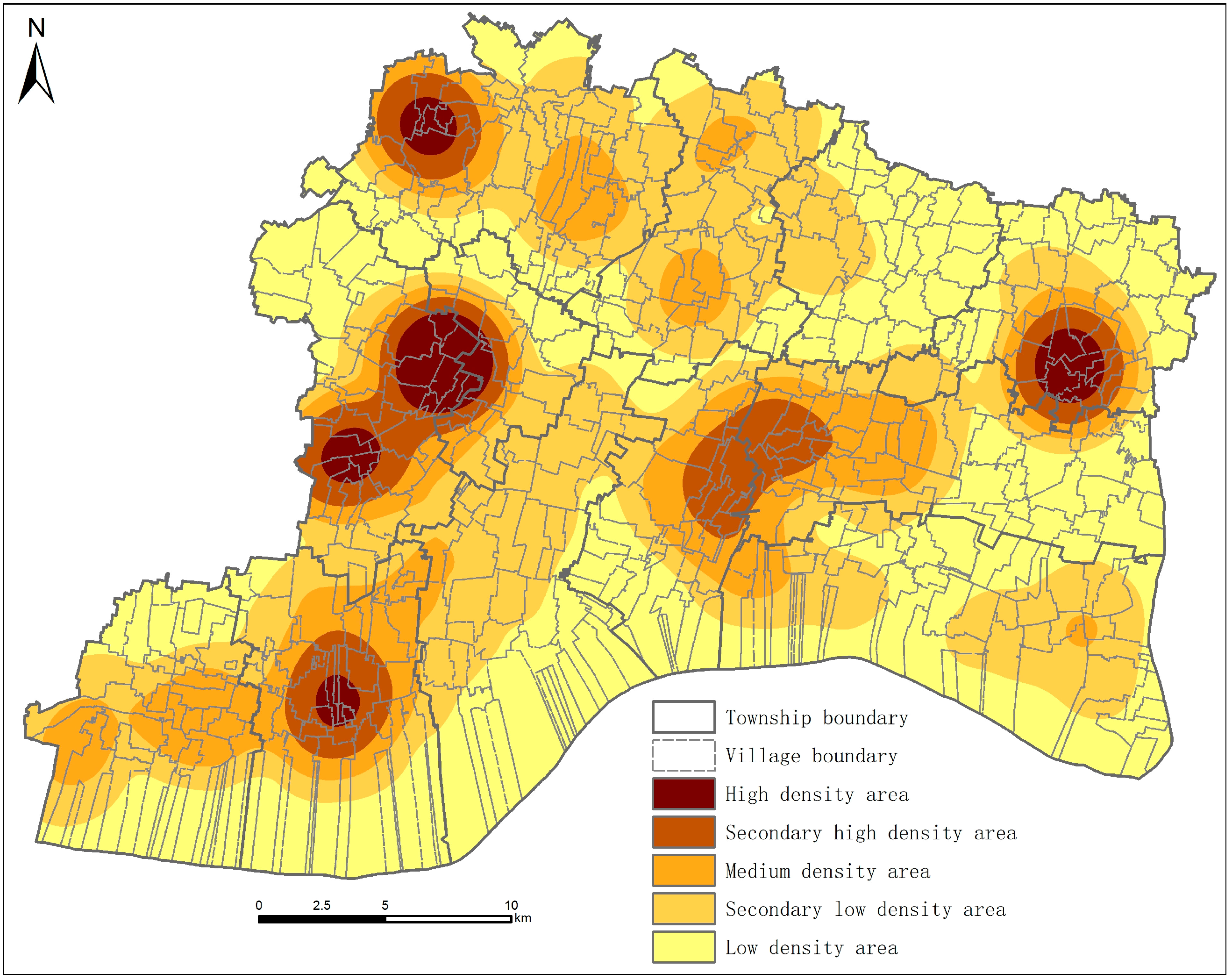
The six types of POI data were superimposed according to their weight to form five core areas in Yuanyang County in terms of cultivated land leisure service supply capacity, which are located in Funingji Village, Gebukou Village (dual core), Qijie Town, and Guanchang Town, showing a distribution of “multiple cores and multiple circles” (
Figure 4). As a key node that links the suburbs of Xinxiang and Yuanyang, Funingji Village attracts numerous urban residents with its superior natural environment and convenient location. Moreover, cultivated land leisure service facilities in Funingji Village, such as farmers’ markets, picking gardens, farmhouse cooking, and homestays, are constantly emerging. Gebukou Village, as an urban development extension area, has formed a land use pattern of semi-cultivated land and semi-construction land, which can not only provide tourists with natural landscapes, but also guarantee high-quality accommodation services. Thus, a large number of leisure service facilities such as agritourism companies, farm stores, and nursing homes have emerged here. Qijie Town is located in the center of the triangle formed by Yuanyang County, Yanjin County, and Fengqiu County, and is the intersection of the intercounty highways. Many catering, shopping, and accommodation service facilities related to cultivated land leisure can be found here. Yuanyang County is a key area for the integration development of Zhengzhou and Xinxiang. Guanchang Town serves as the gateway because it is the first stop on the way from Zhengzhou to Yuanyang after crossing the Yellow River. Its superior location promotes the cultivated land leisure service function and makes it a one-day trip destination for urban residents in Zhengzhou. Its leisure service facilities mainly include farms, farming and animal husbandry bases, and agricultural product stores, with few accommodation services and multiday leisure activities. In addition, a sub-high-density area endowed with rich natural resources has formed near Taiping Town. Rice field is the dominant landscape feature, and the concurrent rice–shrimp–crab farming system not only improves the quality of agricultural products, but also serves as an agricultural landscape. Rural tourism complexes represented by Yellow River Rice Farmer and Buffalo Rice have attracted numerous tourists to experience farming and farmhouse beds and meals, thereby showing the effect of the cultivated land leisure service function. In general, cultivated land leisure service facilities in Yuanyang are distributed in multiple centers rather than in a single core, which is conducive to the proper utilization of all cultivated land resources in the county.
3.2. Comprehensive Evaluation of the Cultivated Land Leisure Service Function
3.2.1. Spatial Distribution of the Cultivated Land Leisure Service Function
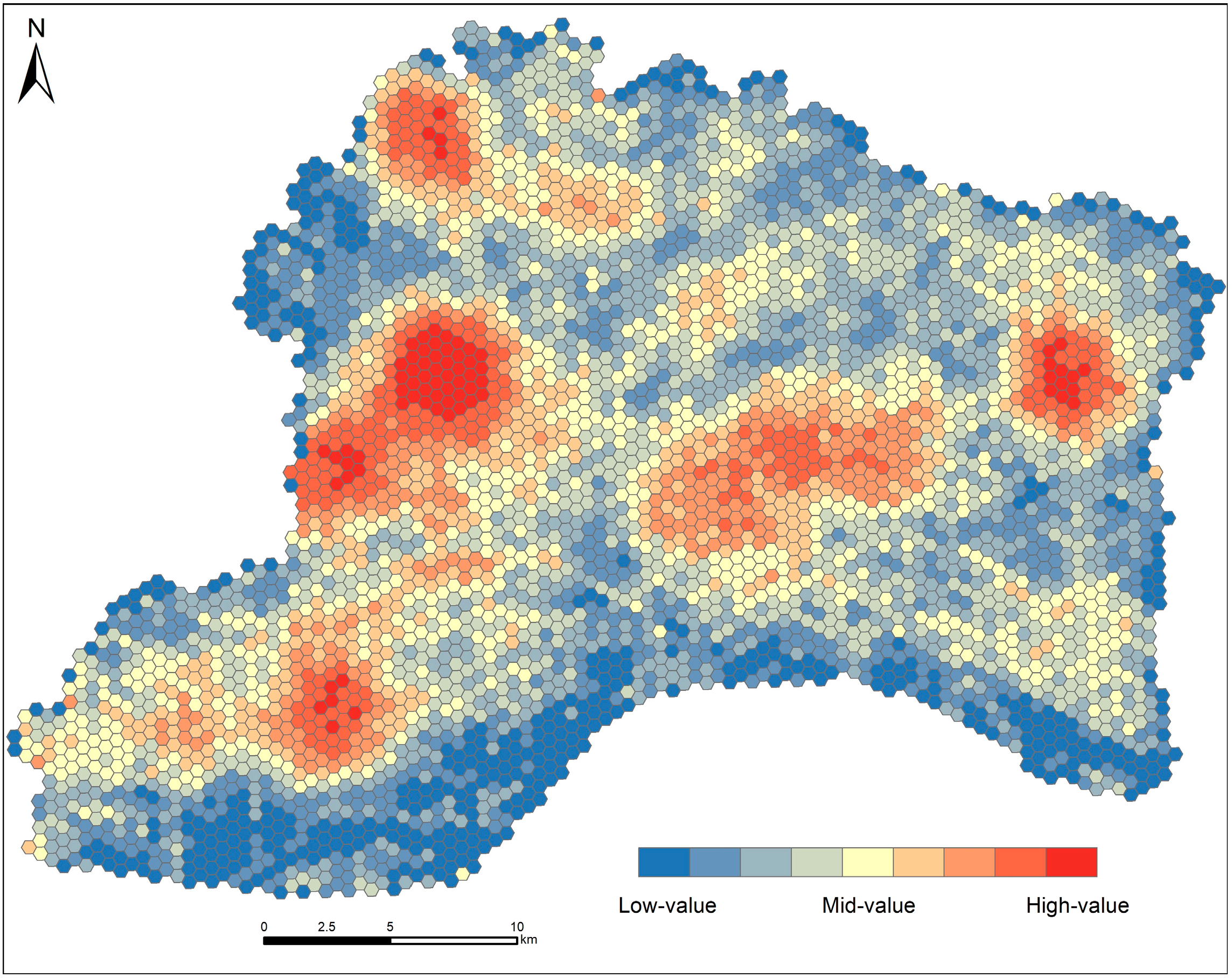
The overall spatial distribution of the cultivated land leisure service function in Yuanyang County features high-value areas clustered at multiple points, median-value areas that surround high-value areas, and low-value areas distributed at the outermost of the circle (
Figure 5). High-value areas are mainly distributed around the urban area and towns to form six centers, located in Funingji Town, Yuanxing and Yanghe residential districts, Gebukou Village, Taiping Town-Dabin Town, Qijie Town, and Guanchang Town. The Yuanxing and Yanghe residential district center has the highest function value and is the core area that undertakes the cultivated land leisure service in the county. Adjacent to it is the Gebukou Village center, and the area between the two also has strong service functions, playing the role of coordinated development and integration. Despite its location within the high-value area, the Guanchang Town center is relatively weak in terms of function, and it is surrounded by the largest agglomeration of median-value areas, which closely connect the Guanchang Town center with the Yuanxing and Yanghe center and Gebukou Village center, and the three form the largest cultivated land leisure service function circle in Yuanyang. The Taiping Town–Dabin Town center is the largest area with medium-high values and has the largest service area. However, it has fewer high-value areas, and around it are several median-value areas; together, they form the second largest service circle. The Funingji Town center and the Qijie Town center are relatively isolated, with smaller high-value areas with lower functional intensity. Several service circles have formed around each center, but they are smaller in size and weaker in service functions compared with other circles. Aside from the four service circles, a large agglomeration of median-value areas has formed in some parts of the Funingji Town, Yang’e Village, and Doumen Village. Most of the cultivated land leisure service function low-value areas are distributed at county borders and a few between the circles. The largest number and scope of low-value areas are found along the Yellow River.
3.2.2. Zoning Characteristics of the Cultivated Land Leisure Service Function
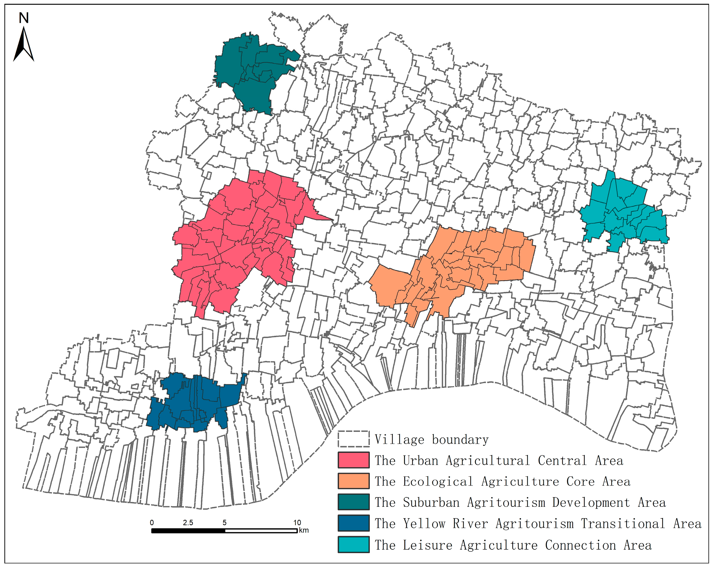
The cultivated land leisure service function in Yuanyang County presents a clear spatial differentiation, that is, homogeneous areas are distributed in clusters (
Figure 6). The natural breakpoint method was used to calculate the local Gi* indices of the cultivated land leisure service function, and four types of areas, namely, the hot spot, sub-hot spot, sub-cold spot, and cold spot, were divided in order from the highest value to the lowest. The hot spot is the major regional cultivated land leisure service function supply area and radiation center, while the cultivated land leisure service function of the non-hot spots benefits from the radiation of the regional hot spots, and cultivated land in such areas still undertakes the major role of crop production. Therefore, research on cultivated land leisure service function in the study area needs to focus on the hot spots, which present a spatial layout of multicore agglomeration. According to the regional characteristics and zoning of functions, the five hot spots are the Urban Agricultural Central Area (area of Yuanxing and Yanghe residential districts and Gebukou Village), the Ecological Agriculture Core Area (area of Taiping Town and Dabin Town), the Suburban Agritourism Development Area (Funingji Town area), the Yellow River Agritourism Transitional Area (Guanchang Town area), and the Leisure Agriculture Connection Area (Qijie Town area).
The Urban Agricultural Central Area is the tourism service center of the whole county. Its superior geographical location and excellent infrastructure have enabled the leisure function of limited cultivated land resources to be maximized, and thus, the largest hot spot is formed. Many catering, shopping, tourism, and leisure facilities related to cultivated land leisure function are present in this area. Its location allows it to not only benefit from the ample facilities around the county, but also possess a combination of urban and rural landscape and convenient location. The Ecological Agriculture Core Area is a central part of the Yellow River Beach Ecotourism Area. It is one of the few planting areas dominated by paddy fields in the county. With the current booming ecological agriculture and agritourism and thanks to the superior natural landscape and policy guidance, this area is able to undertake diversified cultivated land leisure service functions such as catering, accommodation, and tourism. The mechanisms for the hot spot formation in the Suburban Agritourism Development Area and the Yellow River Agritourism Transitional Area are similar. The two areas have rich cultivated land resources and good natural environment, and both are important nodes that connect the surrounding cities. Their complete road networks and convenient locations have promoted the emergence of the cultivated land leisure service function. The only difference is that the Yellow River Agritourism Transitional Area mainly provides short-term leisure services, most of which are catering services such as farmhouse cooking, while the Suburban Agritourism Development Area mainly provides services such as accommodation. The Leisure Agriculture Connection Area is located in the traditional grain growing area, and its prominent cultivated land leisure service function benefits from its location at the intersection of the interconnected highways that link Yuanyang, Yanjin, and Fengqiu counties. High social mobility has stimulated high demand for catering and accommodation services, and the high-quality cultivated land has brought about many farmers’ markets and flower and plant markets.
The effect of the cultivated land leisure service function is not only affected by the condition of natural resources but is also closely related to location and transportation accessibility. The Ecological Agriculture Core Area is endowed with rich natural resources such as cultivated land, but it has an unfavorable location and poor road conditions. The Urban Agricultural Central Area has limited cultivated land resources, but it is well placed and accessible. Therefore, the effect of the cultivated land leisure service function of the latter is stronger than that of the former. The Leisure Agriculture Connection Area is located in the heartland of the intersection of Yuanyang, Yanjin, and Fengqiu counties, and the Suburban Agritourism Development Area, the Urban Agricultural Central Area, and the Yellow River Agritourism Transitional Area are all located on the axis of the Beijing–Hong Kong–Macau Expressway. Their superior location and transportation conditions can promote the circulation of people and products, drive economic development, and promote the effect of the cultivated land leisure service function.
3.3. Suggestions for Improving the Cultivated Land Leisure Service Function Division
On the basis of the above findings of the cultivated land leisure service function in Yuanyang County, suggestions for improving the service function are presented.
The Urban Agricultural Central Area, on account of its strongest service function and widest range of services, is the core area of the cultivated land leisure service function in the county. The suggestion is to make good use of the existing infrastructure and commercial atmosphere to provide a variety of leisure and entertainment facilities and improve accommodation services. In addition, this area lacks cultivated land resources and most of the land is designated for construction. Therefore, a necessary step is to strictly control the cultivated land occupation by construction and make full use of the limited cultivated land resources, especially paddy field resources, to create a rich and diverse agritourism landscape. Efforts should be made to continuously strengthen the connection between the county urban area and Gebukou Village in terms of leisure service function and promote the coordinated and integrated development of the two places. Doing so can maximize the economies of scale and improve the quality of cultivated land leisure services in the area. However, attention needs to be paid to the differential development of service functions in the two places, that is, the former will focus on providing services, whereas the latter will focus on providing the landscape.
The Ecological Agriculture Core Area has an abundance of natural resources and a certain foundation for the development of cultivated land leisure services, but the potential of its service function supply has not been fully explored. Location and transportation conditions are the major factors that hinder the development of cultivated land leisure services in this area because the road network is sparse and road facilities that connect surrounding cities and counties are inadequate. Disadvantages of location and transportation can be compensated by building roads and bridges and improving the reputation of the region. First, the road network and road accessibility can be improved, and direct routes to surrounding cities (Zhengzhou, Xinxiang) can be increased. Second, establishing and vigorously advocating for local trademarks, such as Golden Sun Rice and Buffalo Rice, are needed. Aside from ensuring the quality of cultivated land leisure service products, the area needs to increase product types and quantities, provide more catering and shopping services, and develop more attractive leisure and tourism products.
The Suburban Agritourism Development Area, the Yellow River Agritourism Transitional Area, and Leisure Agriculture Connection Area have all seen the formation of hot spots due to their location advantages. Catering, shopping services, and accommodation services are important functions that have attracted residents from surrounding cities. Therefore, these three service functions need to be improved continuously. The Suburban Agritourism Development Area should focus on enhancing landscape diversity, improving landscape quality, and improving the road network to expand the service area of the cultivated land leisure function. Compared with the other two areas, the Yellow River Agritourism Transitional Area attracts more tourists. However, it lacks accommodation service products, so it is necessary to make good use of the ecological tourism resources along the Yellow River to address the loss of tourists. The Leisure Agriculture Connection Area is located at the intersection of the three counties. Despite its superior location, its service area has a small scope. The number of leisure and tourism service facilities should be increased to improve the cultivated land leisure service capacity in this area.
Yuanyang County is a traditional major grain-producing county in the Yellow River Basin and has rich high-quality cultivated land resources. Under the current situation where cultivated land leisure services are distributed in multiple cores, the current quantity and quality of cultivated land resources need to be preserved effectively. The types and the number of cultivated land leisure service function products need to be increased and their quality must be improved continuously. To develop the cultivated land leisure service function, the county should break down the barriers set up by administrative boundaries of towns and villages to realize cross-regional cooperative development and actively improve infrastructure such as roads. The Yellow River Basin is endowed with relatively abundant natural resources, and production problems and ecological security threats can be addressed with engineering and technical methods to fully develop the cultivated land leisure service function along the Yellow River. The cultivated land leisure service functions are distributed mostly around urban areas or market towns, indicating that natural products present the characteristics of commercial agglomeration after being transformed into economic products. Therefore, appropriate market economy measures can be adopted to manage and regulate the cultivated land leisure service function.
4. Discussion
The Yellow River is the mother river of China. Therefore, protecting the ecological environment of the Yellow River Basin and promoting the high-quality economic development of the areas along the Yellow River is the primary mission and practical need in our current era. “Lucid waters and lush mountains are invaluable assets” is China’s philosophy for development. However, economic development and ecological conservation are often trade-offs in the process of development. At present, the development of the leisure service industry appears to be an effective environmental protection approach. However, the current evaluation methods for leisure services have certain drawbacks: First, stated preference methods such as CVM are based on consumers’ willingness to pay under certain assumptions, which is both subjective and uncertain. Second, the premise of the revealed preference method is that the resources to be evaluated have already been consumed and thus cannot serve the purpose of resource investigation and overall planning. Third, no consensus has been reached with regard to the use of the index evaluation method in terms of analytical framework and index selection. Rather, great differences exist. Finally, compared with the above methods, spatial data acquisition is relatively simple and spatial data can visually demonstrate regional differences in the evaluation of leisure service function. However, relying on single-type spatial data can easily lead to incomplete and inadequate evaluation. For example, POI data are unable to accurately present ground feature information in a large area, and because POI data can reflect economic performance only, it will by no means contribute to a comprehensive evaluation of the object of study. Therefore, this study selected spatial data from the three dimensions of ecological landscape, social activities, and economic performance, which not only provided more angles to complete the evaluation, but also made up for the inaccurate presentation of POI data. Limited by the availability of data, the most important road network density was selected to represent the social activity dimension, which met the basic measurement needs. With the opening and development of spatial data, different types of data can be selected to represent spatial activities to make this dimension more convincing. In this study, all data were normalized and nondimensionalized to facilitate calculation, which is why the results can only reflect regional differences but are not comparable with the currently used units of measurement. The value of leisure services is an integral part of the macro value of natural resources. Therefore, exploring how the value of cultivated land leisure service function is realized, that is, having the ability to measure the function or value and apply it to social and economic activities, is of great significance to the protection and utilization of natural resources, which is also a key area for future research.
5. Conclusions
(1) The landscape resources in the northern part of Yuanyang County are relatively monotonous, whereas those in the southern part are rich and evenly distributed with great potential for cultivated land leisure services. The spatial accessibility is the highest in the county urban area and presents a distribution of multiple subcores in other areas. The large road network is conducive to the formation of multiple centers of the cultivated land leisure service function. The spatial distribution of cultivated land leisure service supply capacity is characterized by “multiple cores and multiple circles,” most of which are located on the periphery of the urban area and at the intersection with other cities and counties.
(2) The effect of the cultivated land leisure service function in Yuanyang County presents a clear spatial differentiation and is closely related to location and transportation conditions. Hot spots present a spatial layout of multicore agglomeration. These hot spots are the Urban Agricultural Central Area in the urban area, the Ecological Agriculture Core Area in Taiping Town-Dabin Town, the Suburban Agritourism Development Area in Funingji Town, the Yellow River Agritourism Transitional Area in Guanchang Town, and the Leisure Agriculture Connection Area in Qijie Town.
(3) The Urban Agricultural Central Area should strictly control the cultivated land occupation by construction and actively create a rich and diverse agritourism landscape; the Ecological Agriculture Core Area should improve its spatial accessibility and vigorously advocate for local trademarks; the Suburban Agritourism Development Area should focus on enhancing landscape diversity and quality; the Yellow River Agritourism Transitional Area needs to make good use of the ecological tourism resources along the Yellow River to address the loss of tourists; and the Leisure Agriculture Connection Area should expand the scope of its service areas and increase the number of leisure and tourism service facilities.


 ,
, 


