1. Introduction and Theoretical Framework
In recent years there has been increasing interest in the management of protected natural spaces and in enlarging the areas covered by different forms of protection, which are widely recognized, especially in Europe, as a potential driver of rural development.
A general analysis of the different experiences across the world [
1] in relation to the protection of natural areas revealed that the enclosure of these areas via the establishment of natural parks often took place through top-down regulatory procedures, involving a series of phases and processes. Rural communities took an active role in defense of their natural spaces, with bottom-up demands for the creation of natural parks as a means of protection and survival in the face of external market forces [
2]. Once these parks had been created, locals also took part in the nature protection and tourism-related activities that gradually developed inside them [
1,
3]. Most of the world’s protected areas are open to some form of anthropogenic use. Indeed, the global expansion of protected areas that took place between the late 1980s and 1990s was mainly concentrated in categories with less stringent levels of protection. These include, for example, the natural parks established in Andalusia in Spain, as well as in other parts of Europe, such as Italy [
4,
5]. However, an analysis of the different experiences at an international level showed that in the last two decades, contrasting trends could be observed (which perhaps require further study), with a strong shift towards more rigorous protection in East Asia and an opposite trend in Latin America and Mediterranean Europe (Ibidem).
Within this process of growing interest in and expansion of protected areas and parks all over the world, there has been a paradigmatic shift in the objectives, from an initial focus on economic growth to a more recent emphasis on sustainable development within the context of biodiversity protection [
1]. There have also been radical changes in the way these areas are managed with a move away from a strict protectionist-type system to one involving the controlled use and enhancement of the protected areas [
6,
7]. In other words, there has been a move away from a static conservationist approach that differentiates and separates the conservation areas from the unprotected areas towards a more relational, dynamic approach that involves multifunctional participatory planning through cooperation between the different stakeholders and interested parties. This trend is especially evident in Europe in the field of rural development [
7,
8,
9,
10,
11]. As a result, the traditional paradigm of nature protection is increasingly associated with biodiversity, sustainable regional development, the enhancement of landscapes, and local and identity culture with an innovative approach and participatory planning.
The various case studies of these processes across the world [
7,
9,
10] also show that they are often plagued by conflict and other problems. These range from uncertainty or disputes as to where the boundaries of these areas should be drawn or regarding the specific objectives of each park, which can vary a great deal across the world’s different regions. Within the context of the new rural paradigm, there are also differences of opinion regarding the most effective forms of management required to achieve objectives such as the conservation of biodiversity, landscapes, and identity values. These require specific interventions not only because the territorial contexts vary greatly in geographical, economic, social, institutional, and regulatory terms [
8] but also because this change often requires the involvement of different actors at different territorial scales within a framework that is affected not just by internal, local forces but also by the global market and wider political events [
7]. Within the neo-endogenous approach to rural development [
12], although the role of local actors is paramount, stakeholders from outside the immediate region can also play their part. However, as will be assumed in this paper, external pressures and demands are perhaps more important. These require a local response in terms of territorial organization and identity, which varies from place to place.
A different approach is therefore required in which the management of natural spaces and the development of rural areas cannot be viewed as separate issues or, as Hidle [
7] argued, by considering only the interests of the state in the management and control of natural parks at the expense of local stakeholders.
However, these territorial contexts are often hampered by the absence or ineffectiveness of specifically programmed local development strategies, not only due to the chronic insufficiency of the financial resources offered by public bodies but also due to the redundancy of territorial governance, which in Italy, as in Spain, sees the parks simultaneously engaged in different partnerships, whose geographical scale, objectives, and vision may be inconsistent with their mission, or worse still, in direct conflict with it, leading to inexorable slowdowns or complete paralysis of their action [
13,
14,
15,
16]. Natural parks, and indeed most other protected areas, continue to suffer from a lack of participation, not only from local communities and stakeholders [
17] but also from decision- and policy-makers, who are not always able to promote and guide the participatory processes that are essential for their success [
15,
16,
18].
This is why the comparative study proposed by Hammer et al. [
8] is of great interest here as a means of unraveling some of the key questions. First of all, the definition of protected areas in terms of the categories to which they belong in order to understand the role they play or could play in territorial development processes. In this case, national parks are by definition conceived as instruments of environmental protection, while natural parks are intended more as instruments of sustainable regional development in rural areas [
19]. However, this distinction is far from uniform across Europe, as shown by the different cases analyzed in this research [
20]. These areas are also affected by the new approach based on sustainable development in which (especially large) protection areas in northern and western Europe are considered tools for regional development. These include, for example, the alpine pastures in Austria or the natural and man-made amenities in natural parks in France, Belgium, and Luxemburg, as well as the agricultural land in Norway and the other amenities collected in the OECD inventory [
21]. In some cases, particular emphasis is placed on the preservation of traditional forms of land use and the protection of the cultural values and traditions of these areas. They also seek to encourage sustainable forms of tourism that are close to nature and respectful of it in a bid to achieve the protection goals while promoting alternative forms of development [
22].
Although sustainable tourism has a synergistic relationship with protected natural areas, in that it can internalize the positive externalities associated with them through the market [
21], tourism could become a critical pressure factor due to the conflicts generated by the increase in accommodation facilities and/or second homes [
13] produced by the process of naturbanization. This also interferes with agriculture, irreversibly compromising the ecological and sociocultural value of the area [
2].
It should also be noted that some authors consider the phenomenon of naturbanization not only acceptable but even necessary for the development of the rural areas surrounding nature parks [
14,
23], especially when, as in the two case studies, they are very close to urban areas, and therefore highly attractive for development purposes and easily accessible [
23].
Although reconciling conservation and development is a challenging and conflicting exercise, business initiatives based on respect for and promotion of natural heritage appear to be the most effective way of avoiding depopulation and abandonment of the territories surrounding or close to protected natural areas [
14]. Conservation policies must therefore be transversal and, above all, capable of integrating priorities from different fields, such as agriculture and tourism, which would support general strategies to combat climate change, based above all on the enhancement of ecosystem services [
2].
Protected areas, and national parks, in particular, can serve as the main driver of the development of the surrounding area and of its economic and social regeneration. Since these areas are normally strongly rural, the launch of an accreditation program for the agricultural and/or agri-food products produced in the area would help support farms that find it hard to compete, thus performing a sociocultural function in addition to providing purely economic support [
14].
Support of this kind is essential for maintaining the socio-ecological balance inside and outside nature parks. Furthermore, the branding of local food products with the park logo would make them more easily recognizable to consumers, many of whom might be willing to pay a price premium as a means of supporting the economy of the park and its surrounding area. This would also help sustain and/or expand a network of agricultural and craft businesses that are willing to work within the ecological constraints imposed by the protection of natural resources [
13,
14]. Above all, it is vital to ensure that natural parks do not become desolate, fossilized places in which all change is prohibited. Instead, we must ensure that their formidable heritage reserve [
14] creates the territorial capital on which to base new participatory local development strategies [
1,
2], according to a system that DeFries et al. (p. 1037) [
13] define as “small loss-big gain”.
The instruments and methods used to manage these areas are also of crucial importance. In this regard, integrated approaches to protected areas can enhance “the multifunctionality of landscapes and rural regions”. To this end, these areas must be viewed not only from an ecological or economic perspective but also from a broader vision of sustainable development that encompasses cultural and social aspects. This integrated approach not only preserves existing social and cultural values but also creates new ones. The maintenance and protection of these new values then become key elements for the economy (in the tourism sector, for example) and for the overall quality of life [
8].
The relationship between the protected area, agriculture, and local dynamics, therefore, remains an open question that is widely debated at an international level [
21].
National parks, which often have a very rich natural, cultural, agricultural, and social heritage, can act as laboratories for assessing policies for local, community-led, sustainable development based on the endogenous resources of the region. At the same time, they can become “living landscapes” in which agriculture can be complemented with a range of different business activities (tourism, handicrafts, education, culture) by borrowing good practices that have been successfully tested elsewhere [
24]. Despite the growth generated in some protected areas due to naturbanization, which, as noted above, mainly affects the areas closest to cities, the abandonment of agriculture and the depopulation of more remote areas continue unabated. Above all, at the turn of the new millennium, there were serious reductions in agricultural areas all over Europe. These were accompanied by an even greater decline in the number of farms. This has brought benefits by favoring the expansion and consolidation of larger, more professionally-managed farms that can compete in increasingly large markets and by increasing the area devoted to woodlands, meadows, and pastures in mountain areas as a result of the fall in the number of livestock farms, especially sheep and goats. However, the aggressive agricultural modernization policies underlying these trends have not succeeded in imposing a uniform, highly productive model of agriculture, which means that, especially in protected areas, small-scale “peasant” agriculture continues to play a fundamental role [
25] as a model that is capable of integrating production and the associated ecosystem services [
2,
26,
27].
On the basis of these assumptions, this study aims to compare farming specialization in two protected areas, the Sierra Nevada National Park (Andalusia, Spain) and the Alta Murgia National Park (Apulia, Italy), in order to identify similarities and/or differences attributable to their new status as nature reserves. This will be done, specifically, by considering land use, which could be an indicator of rural/local development dynamics.
The study proposes to assess the effectiveness of the national parks in bringing about a revival of these places and to reflect on the new opportunities and scenarios for rural development. By analyzing the dynamics of farming specialization, we try to identify the areas (groups of municipalities) in which this process is most evident. The results obtained will provide a focus for subsequent research in this field and will help assess to what extent and how this shift in farming (towards more extensive, sustainable, and diversified crops or breeds) has been implemented and what policy implications can be drawn. The most frequent changes include the extensification of farming, the abandonment of farmland, and the loss of traditional crops and agrarian landscapes.
2. Materials and Methods
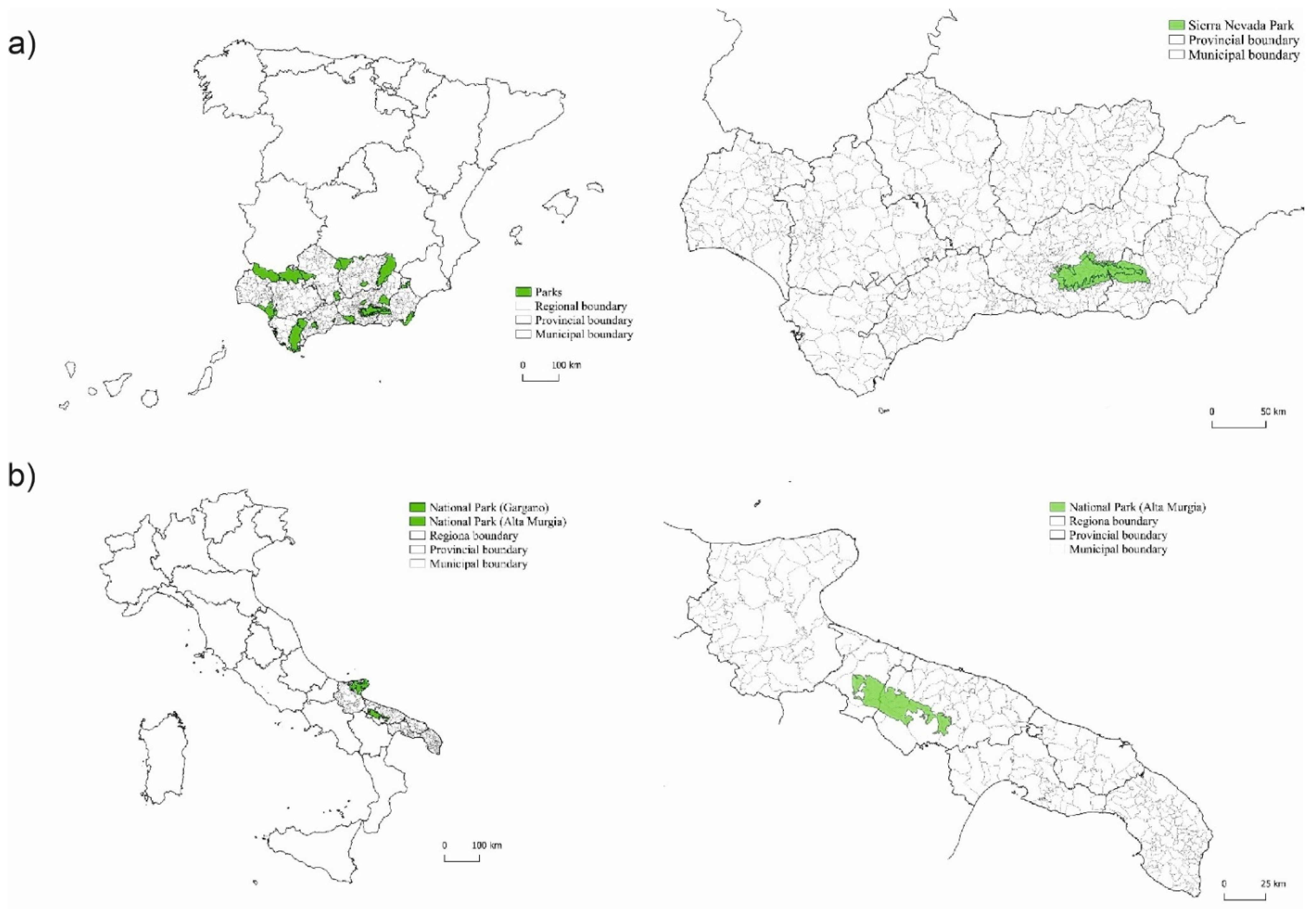
The study analyses, over a 20-year period between 2 agrarian censuses, the trends in agricultural and livestock farming in the Sierra Nevada National Park (SNP) in Spain and the Alta Murgia National Park (AMP) in Italy. These national parks were specifically selected for various reasons. First, because they are in peripheral, predominantly rural regions of southern Europe, with quite marginal economic conditions, and secondly, because they have a long experience in bottom-up practices, in particular the LEADER approach, and have similar geographical and economic situations, with an increasing number of natural and rural tourism-related activities, particularly in the Spanish case, and a declining farming sector. At the same time, each case study has its own specific structural and social characteristics and has followed its own particular path towards agrarian transformation over time. This makes their analysis and comparison even more interesting in attempting to identify unusual evolutionary dynamics. Moreover, the two national parks selected for the study are of great interest because they contain several medium–large-sized municipalities connected to metropolitan areas, which could be experiencing underlying phenomena of naturbanization (
Figure 1).
2.1. Study Areas
2.1.1. Sierra Nevada National Park
The Sierra Nevada Natural Area is made up of a national park and a natural park. It was regulated by Decree 238/2011, which established the Plan for the Management of Natural Resources (PMNR) and the Plan for Use and Management (PUM) for both parks. While the first of these plans has permanent validity and sets out the various possible uses and benefits based on the capacity of its ecosystems, the second plan is open to periodic review.
There are four different levels of protection in the Sierra Nevada National and Natural Parks. In the national park, there are (i) reserve areas—those with the highest level of protection, occupying 0.35% of the almost 86,000 hectares of this park—human land uses are not permitted; (ii) areas with restricted use, which cover 76.1% of the total area and correspond to high mountain spaces largely unaffected by human action and with very limited uses such as traditional agriculture, forestry, and livestock farming, as well as organic, integrated production; (iii) areas of moderate use—mostly agricultural land, covering 23.51% of the total area and more affected by human action; and (iv) areas with a specific use, which are devoted to infrastructure and cover just 48 hectares.
For its part, the natural park is divided into (i) reserve areas, those with the highest levels of protection, which occupy 0.36% of the total surface area (86,355 hectares)—any currently existing agricultural activity that does not alter the surrounding ecosystems is permitted; (ii) special regulation zones (of which there are 4 subtypes), which cover 55.1% of the total area and have a lower level of environmental requirements, allowing forestry, livestock, hunting, beekeeping, and public uses, as long as they do not alter the protected ecosystems; (iii) common regulation zones, covering 44% of the total area, in which farming and housing are permitted, as is the ski resort, the most problematic area. In the farmed areas, there are restrictions on water use and work affecting the landscape, such as the conversion of rainfed land into irrigated land or the movement of soils and rocks for planting new crops. The installation of special systems to protect crops against hail is only allowed at altitudes of less than 900 m. And finally, (iv) the areas excluded from environmental zoning (0.6% of the total area).
The Sierra Nevada mountain range was declared a natural park in 1989, and 10 years later, the highest parts were declared a national park. The protected area covers a total of 172,318 ha, of which 86,435 ha belongs to the natural park and 85,883 ha to the national park. Sixty municipalities belonging to the Provinces of Almería and Granada fall within these protected areas. The Sierra Nevada also contains the highest peak in the Iberian Peninsula (Mulhacen, 3479 m) (
Table 1).
The national park covers the area of high peaks and mountains, while the natural park covers the peripheral area surrounding it. This means that the levels of protection and the permitted land uses in each area of the Sierra Nevada vary according to their altitude [
28].
The distribution of land uses in the Sierra Nevada is also a result of socioeconomic and political factors. As explained by Jiménez et al. (p. 500) [
29], “the policies of reforestation led to a huge increase in the coniferous forest, which has extended into agricultural areas and, occasionally, beyond the existing tree limit. The advance of forested land is attributable also to spontaneous processes of ecological succession (…) in parallel to a decrease in human pressure on land”. The consolidation and restrictions on land uses imposed by the National and Natural Park Plans have helped drive this trend. At the same time, traditional farming systems, especially terraced crops on the steep mountainsides, are gradually being abandoned.
2.1.2. Alta Murgia Park
Under Italian law (n. 394/91), national parks consist of terrestrial, river, lake, or marine areas containing one or more ecosystems, either intact or partially altered by anthropic intervention, and one or more physical, geological, geomorphological, or biological formations with natural, scientific, aesthetic, cultural, educational, and recreational values of such international or national importance as to require the intervention of the state to ensure their conservation for present and future generations. The Alta Murgia Park, one of the 26 Italian national parks regulated by the Ministry of the Environment, was established in 2004, with an area of over 68,000 hectares, making it one of the largest in Italy. Defined as a special protection area due to the significant biodiversity recognized at the EU and national level, it also includes various interesting natural features such as karst phenomena and steppe habitats (among the largest in Italy), as well as representing a fundamental hub for the national Ecological Network. This national and regional recognition ensures that this area of extraordinary ecological value is seen as an open system that forms part of an extraordinary network with different resources and functions and can be used, from a sustainable development perspective, for a range of economic activities, in particular agriculture and quality tourism, as planned recently by the regional government. In fact, the park area was first recognized as an area of great natural and landscape value in the “Landscape” Thematic Urban Plan of 2000. This plan identified specific territorial areas characterized by a varying level of landscape and environmental values with varying restriction regimes and levels of protection. Later, in 2010, it formed part of the Regional Territorial Landscape Plan, which was better coordinated with existing territorial strategies, and was based on an analysis of the state and the dynamics of the whole territory
. In fact, the Alta Murgia National Park falls within the “Alta Murgia” Landscape Area, in which landscape assets relating to hydrological, geological, and morphological aspects of the environmental ecosystem have been identified and mapped, together with the area’s cultural heritage, and in particular rural landscapes and their agronomic and cultural characteristics. The area we see today is the result of complex transformation processes over time caused by agricultural, forestry, and shepherding activities. It is part of the vast Murge plateau, characterized by karst phenomena, which was significantly altered by anthropic action, especially during the last century, such as deforestation and stone removal, especially for agricultural purposes. These activities have upset the delicate equilibrium of the ecosystem and caused the loss of typical landscapes [
30,
31]. The national park includes 13 towns with different socioeconomic situations and growth trends, which could act as connectors with belt areas (see
Table 2).
2.2. Methods
In the first case (Sierra Nevada), our analysis centered on the period 1989–2009, while in the second (Alta Murgia), we focused on 1990–2010. The (largely irrelevant) one-year lag between the two case studies was due to the different census periods in the two countries.
The study period was chosen in order to enable us to analyze the situation before and after the establishment of the two national parks. The Sierra Nevada National Park (SNP) was established in 1999, and the Alta Murgia National Park (AMP) in 2004. The end year (2009 or 2010) is the date of the last census for which data is available. This allowed us to observe whether the establishment of the national parks influenced agriculture in the municipalities that fell within their boundaries.
Variations in absolute terms in the crops being grown or in the number of livestock being reared only partially reflect the effects of the establishment of a park on the production choices made by farms. This is because these figures fail to grasp the influence of other contextual conditions underlying these changes, such as the decline in the cultivated area and the changes in the relative distribution of this area.
The analysis was conducted using a relative concentration or production specialization index [
32] that was capable of recording the increase/decrease in the relative importance of a crop or livestock in a specific territory, independently of any downsizing of the cultivated areas and/or the number of animals registered there.
The Production Specialization Index or
PSI was calculated for all the municipalities in the Alta Murgia (AMP) and Sierra Nevada (SNP) Parks. The SNP was divided into two distinct sub-areas, formed by the Natural Park (PAR_NAT) and the National Park (PAR_NAZ). In 1989, thanks to the Special Plan for the Protection of the Physical Environment and the Law establishing an Inventory of Natural Areas, the regional government of Andalusia declared Sierra Nevada a natural park, in which only sustainable activities were allowed. In 1999, the highest parts of the Sierra were awarded the highest protection status when they were declared a national park [
29].
We will also be looking at the surrounding areas bordering the two parks in order to detect any possible differences between neighboring areas situated inside and outside the park. We will also try to assess how the establishment of the two parks impacted the areas closest to them. The differences in the size of the two parks in terms of both surface area (SNP 1718 km2 and AMP 680 km2) and the number of municipalities (the SNP covers 60 municipalities, while the AMP covers 13) also helped us analyze the possible implications of the size of protected areas.
With this in mind, two different datasets were prepared for the years 1989/1990 and 2009/2010 for the two parks (SNP and AMP). The first detailed the different purposes to which the agricultural areas of each park were put (cereals, potatoes, legumes, fruit trees, olive trees, vines, forage crops, meadows and pastures, and vegetable gardens), while the second set out the distribution of the main livestock species (cattle, sheep, goats, pigs, and horses) in terms of their number in each municipality. The latter were normalized by applying specific coefficients (Cattle 0.75; horses 1; sheep 0.11; goats 0.11; pigs 0.3).
For each municipality, we calculated the
PSI for each crop and for each species by applying the following expression:
in which:
where:
= area of the crop/livestock (i) in each municipality (j) of the Parks or Regions to which they belong (Andalusia in Spain and Apulia in Italy).
And a is either–(i) the area devoted to each crop as a percentage of the total agricultural area or (ii) the number of each livestock species as a percentage of the total in each municipality in the two parks.
b shows the average percentages for the region as a whole.
The PSI can vary between +1 and −1. These values correspond, respectively, to a state of maximum specialization (+1) in which a single crop/species is the only one grown or reared in the municipality or absolute de-specialization (−1) when said crop/species is not grown or reared at all.
In addition to making the evaluation of the degree of specialization/de-specialization in each municipality intuitive with respect to the neutral value (value 0), this index is particularly suitable for the space–time comparisons proposed in this research.
By comparing the PSI values for each municipality before and after the establishment of the two parks, we can assess the effects of belonging to a protected area. The constraints that protected status can impose on agricultural production in the area, as well as the new social functions attributed to them, may affect the production systems applied on the farms situated within park boundaries and in the municipalities immediately adjacent to them (“belt” areas), which are also considered in this study.
In order to refine and corroborate the interpretation of these results, we also analyzed the differences in
PSI values over time using the following expression [
32]:
in which:
a and
b have the same meaning explained above, while
a0 and
b0 refer to the values recorded at the beginning of the study period and
at and
bt to the values at the end.
Kt/0 corresponds to the denominator of the
PSI for the same years:
By calculating the difference in the PSI values registered before and after the establishment of the parks (PSIt − PSI0), we can obtain a dynamic interpretation of the changes in production specialization (DPSI). These can be broken down into three different elements or “components”, from which we can obtain a more precise assessment of the influence of the establishment of the parks on the production structure of the farming sector within their boundaries.
The term of the DPSI expresses the endogenous contribution to the changes in that it refers to the variations in the shares of each crop/livestock species in each municipality in the park (and in the belt).
For its part, the term of the DPSI expresses the exogenous influence on these changes, as it measures the variations in the shares of each crop/livestock species in the regions (Andalusia and Apulia) as a whole.
Finally, the term of the DPSI is a residual component, which assesses the combined influence of the two previous components, and is therefore attributable to the prevailing economic, cultural, and political context.
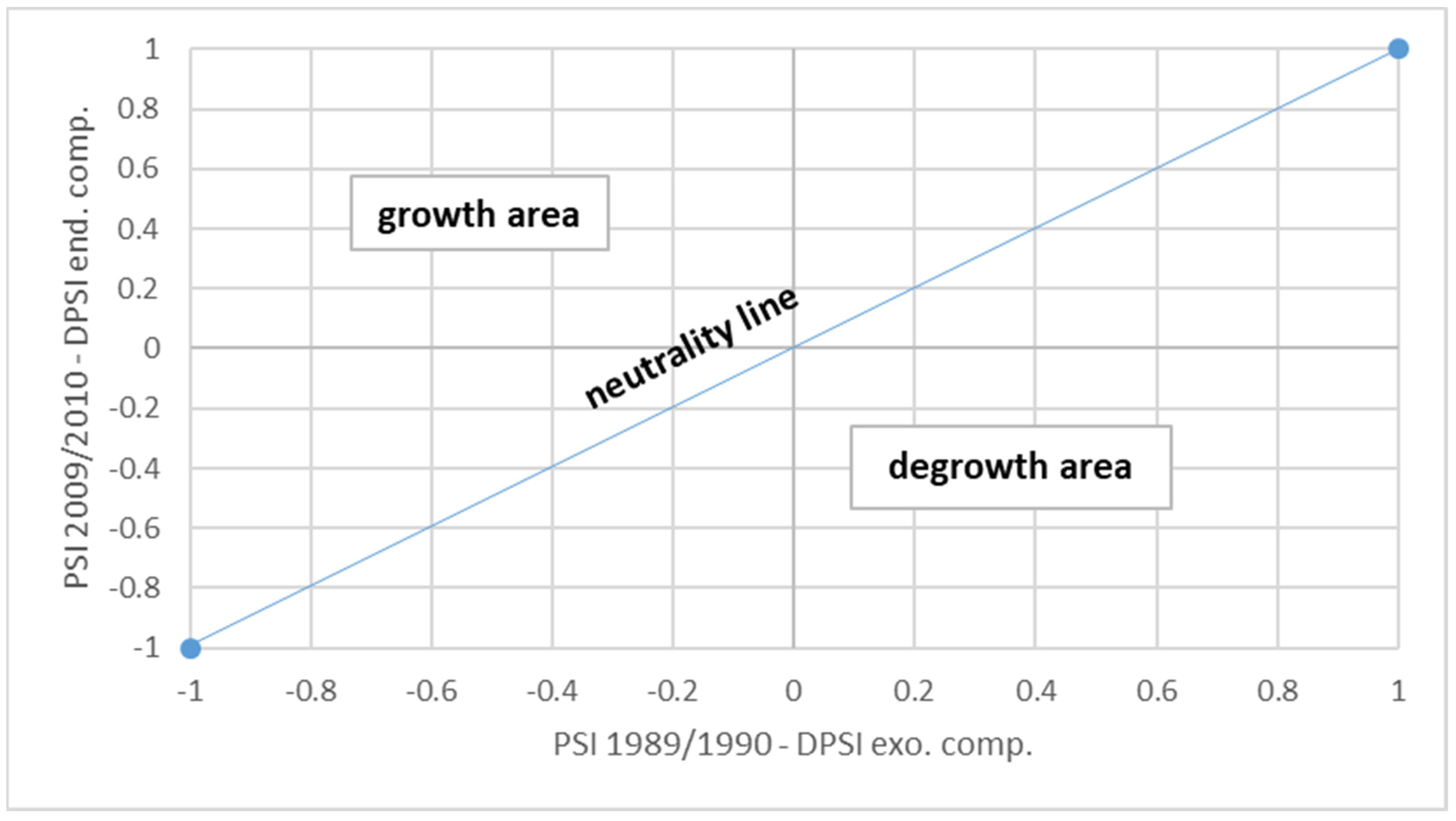
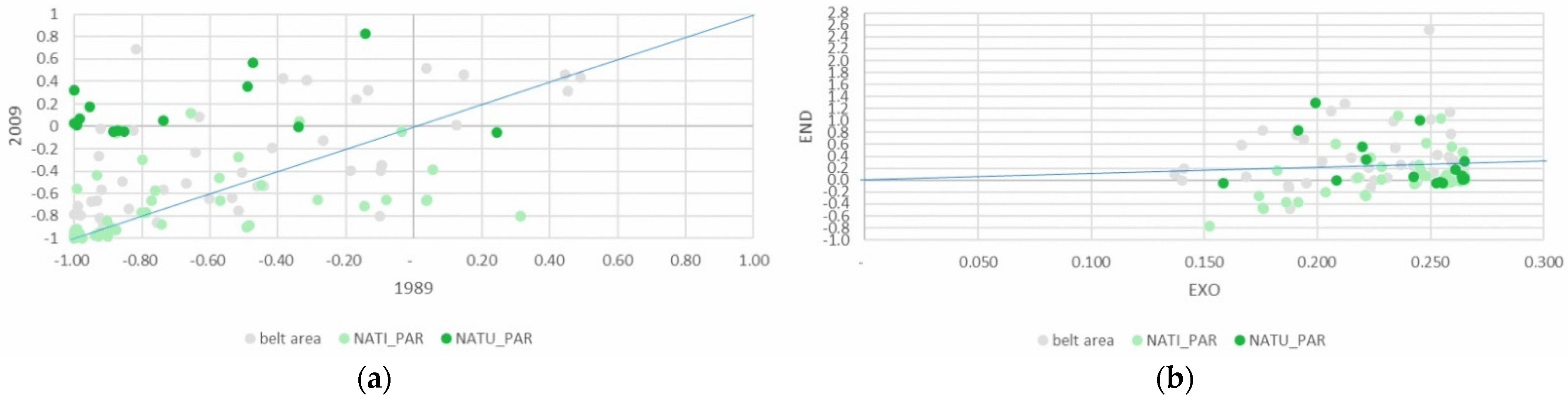
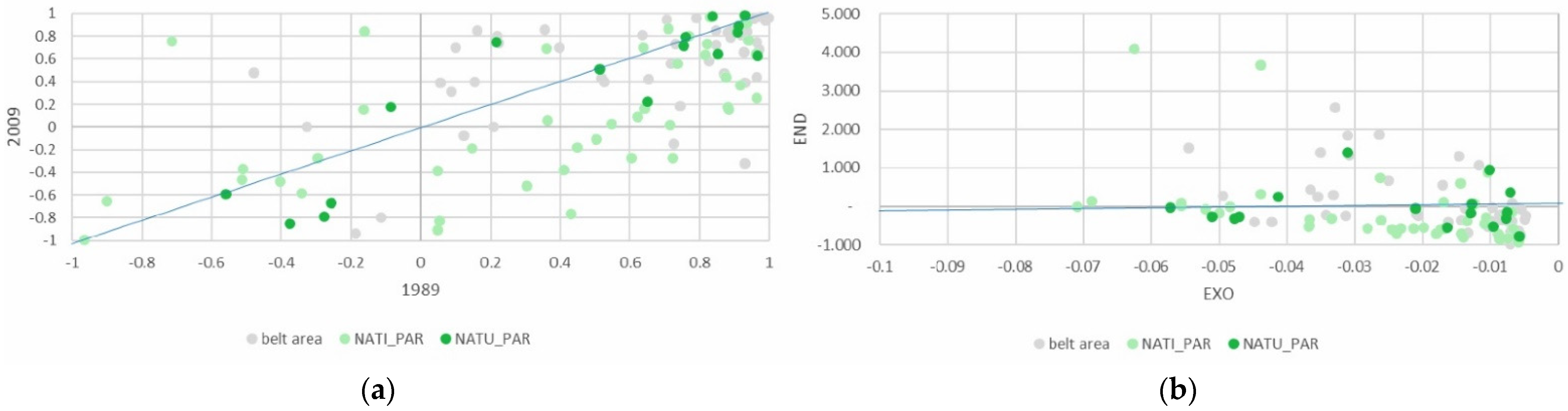
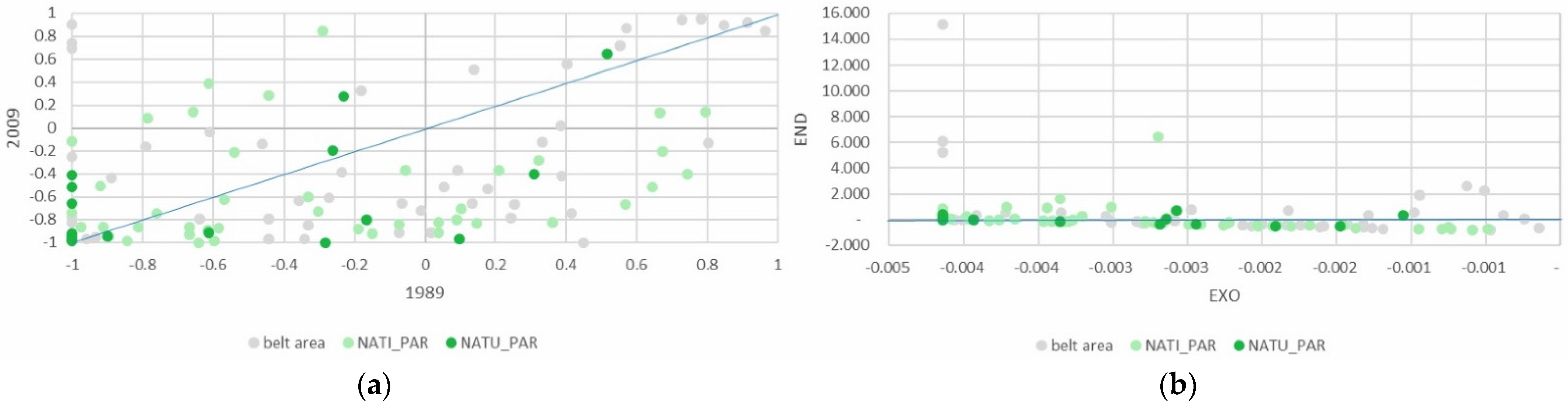
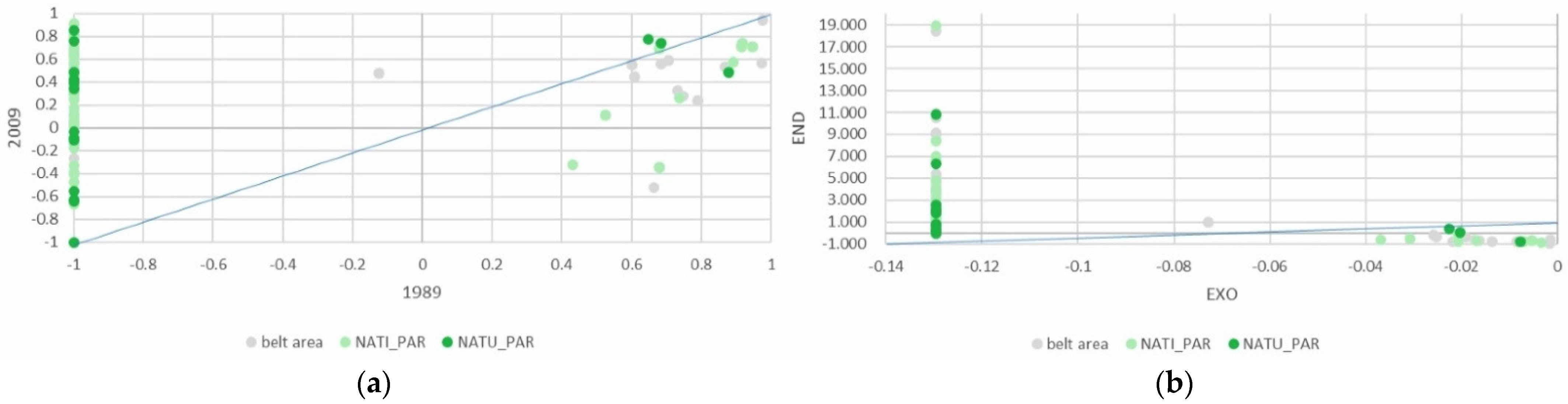
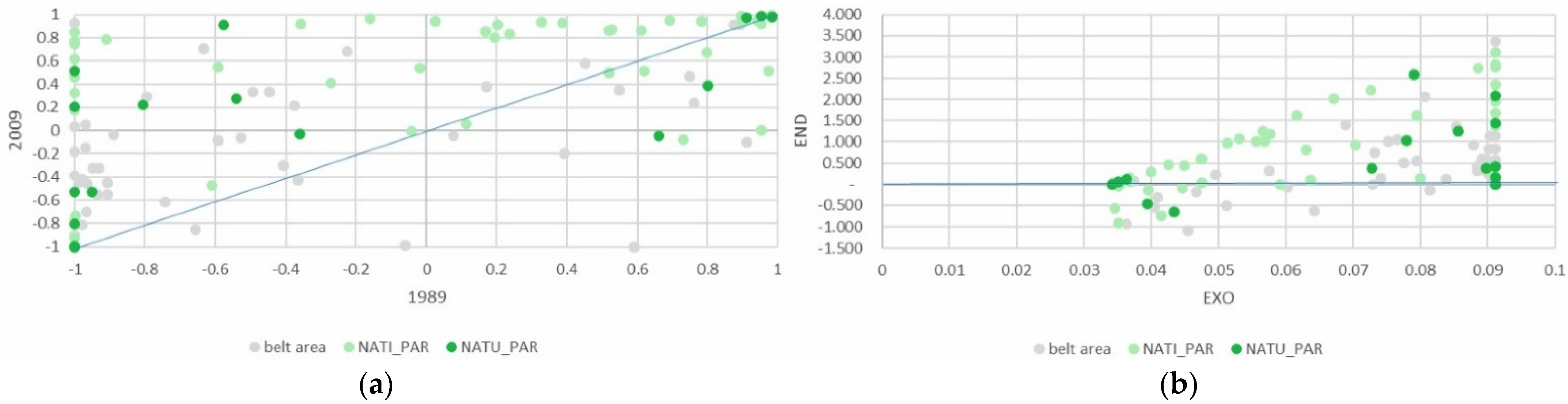
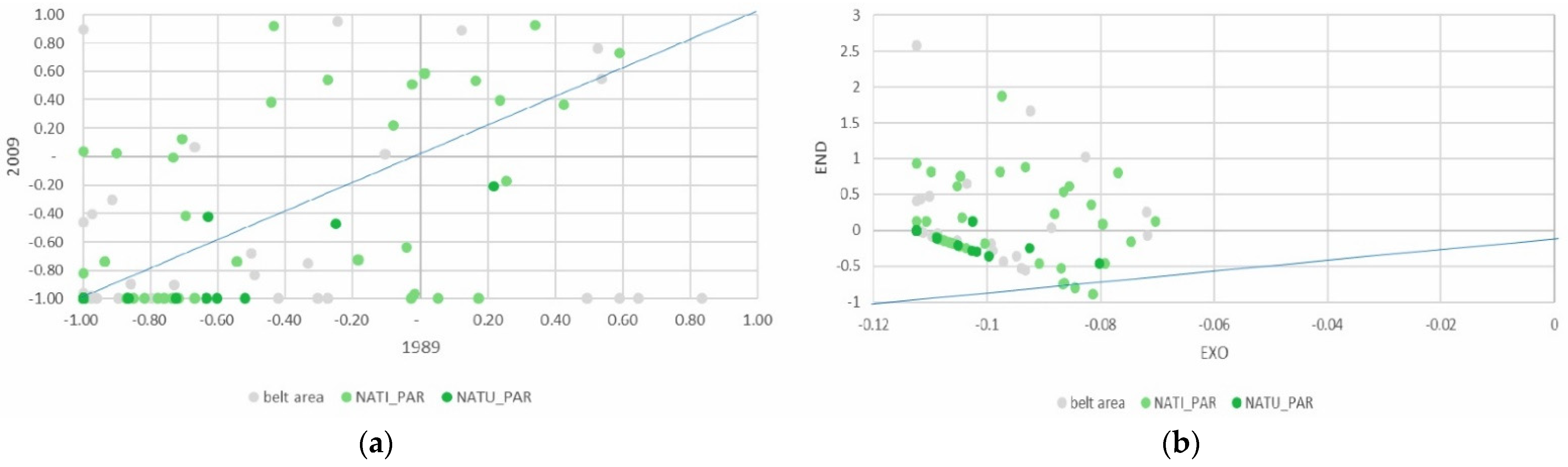
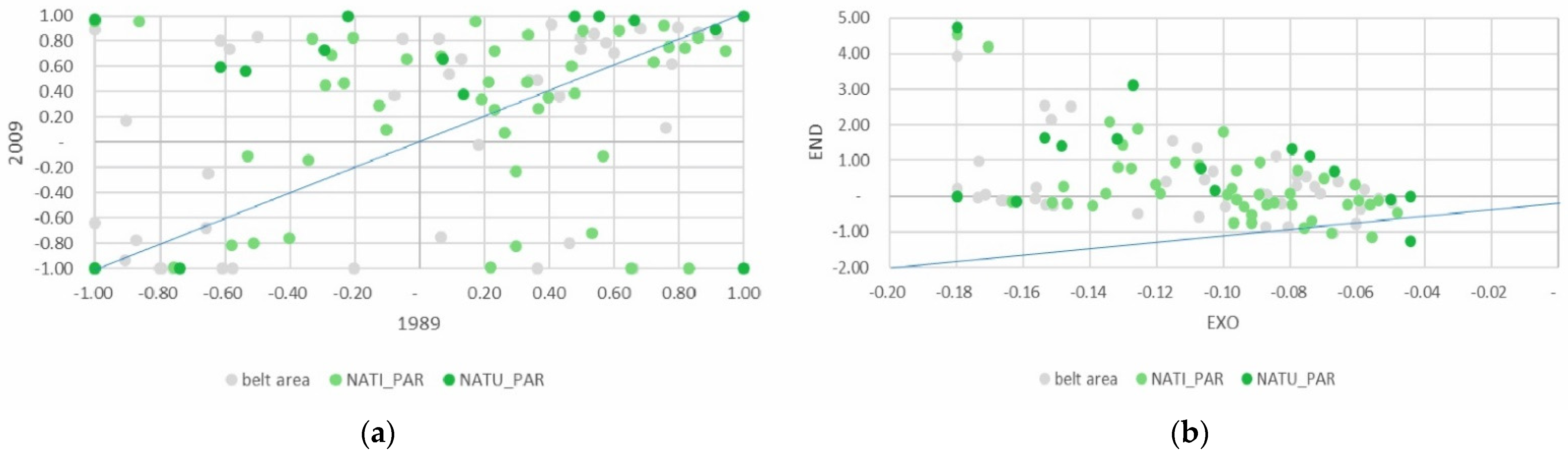
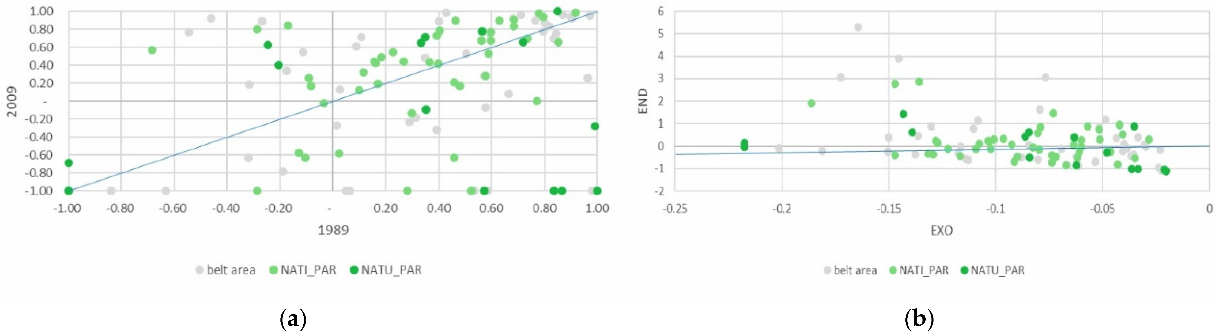
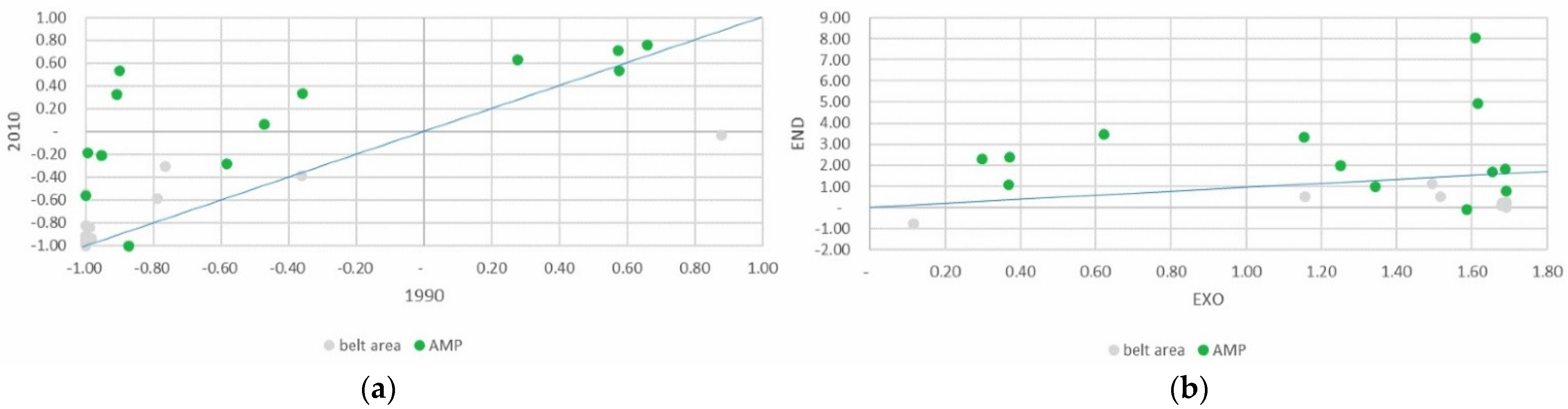
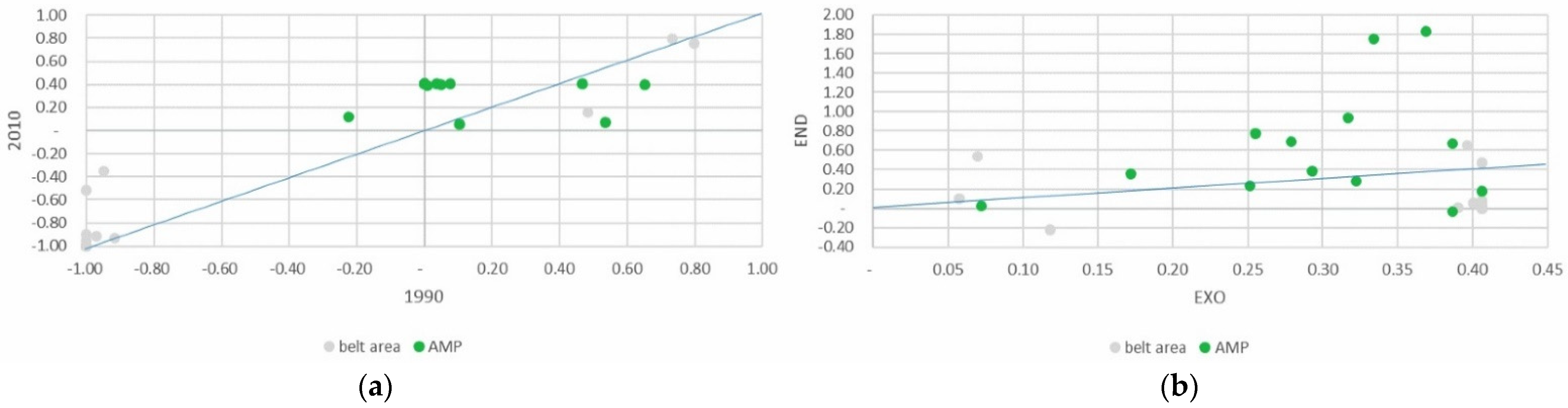
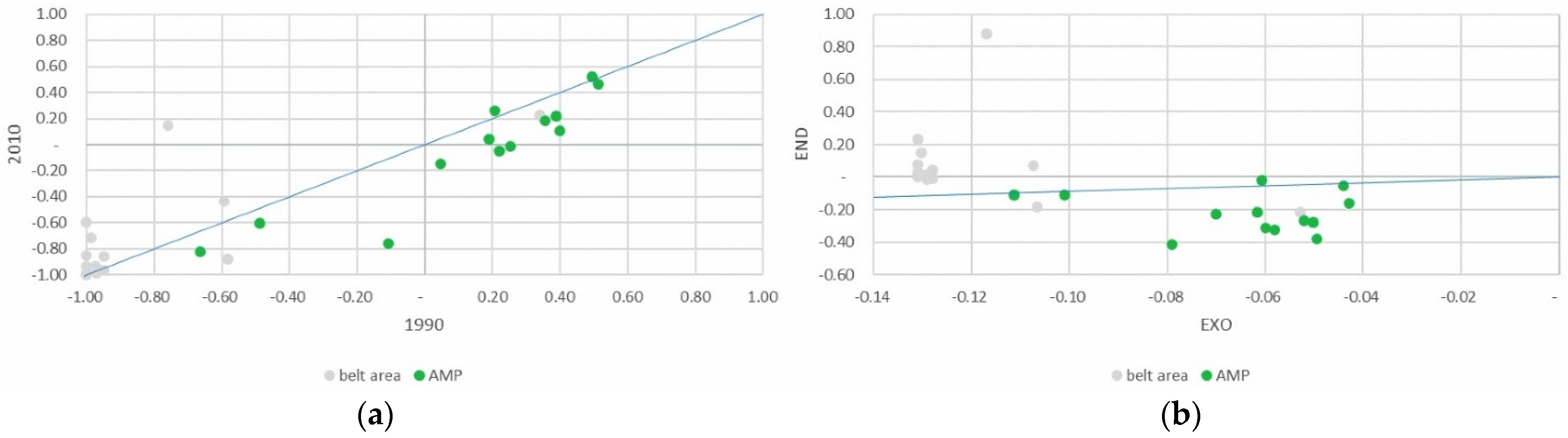
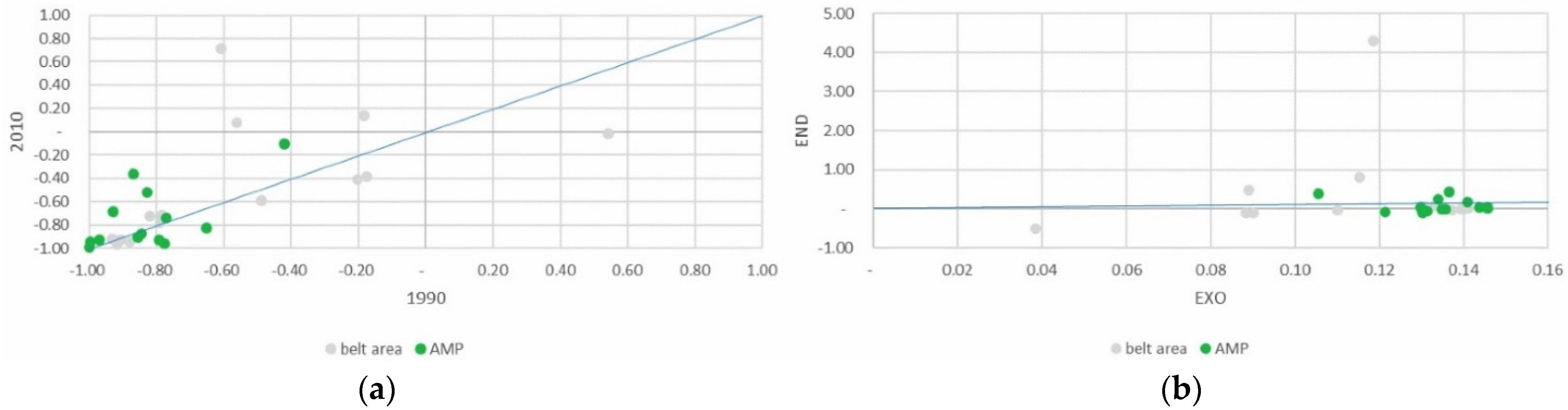
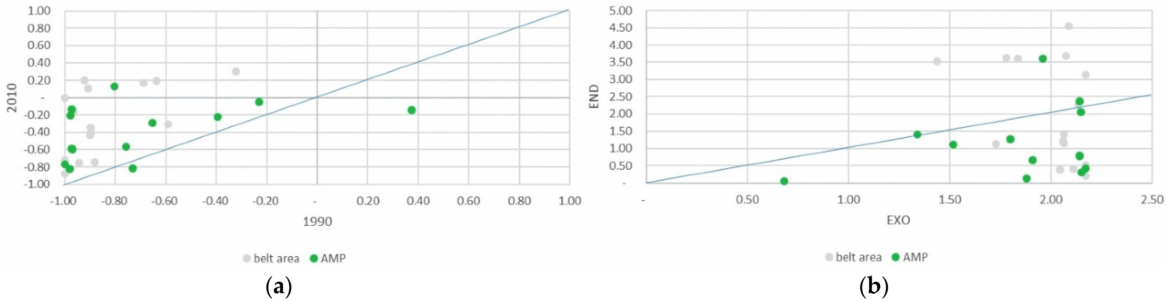
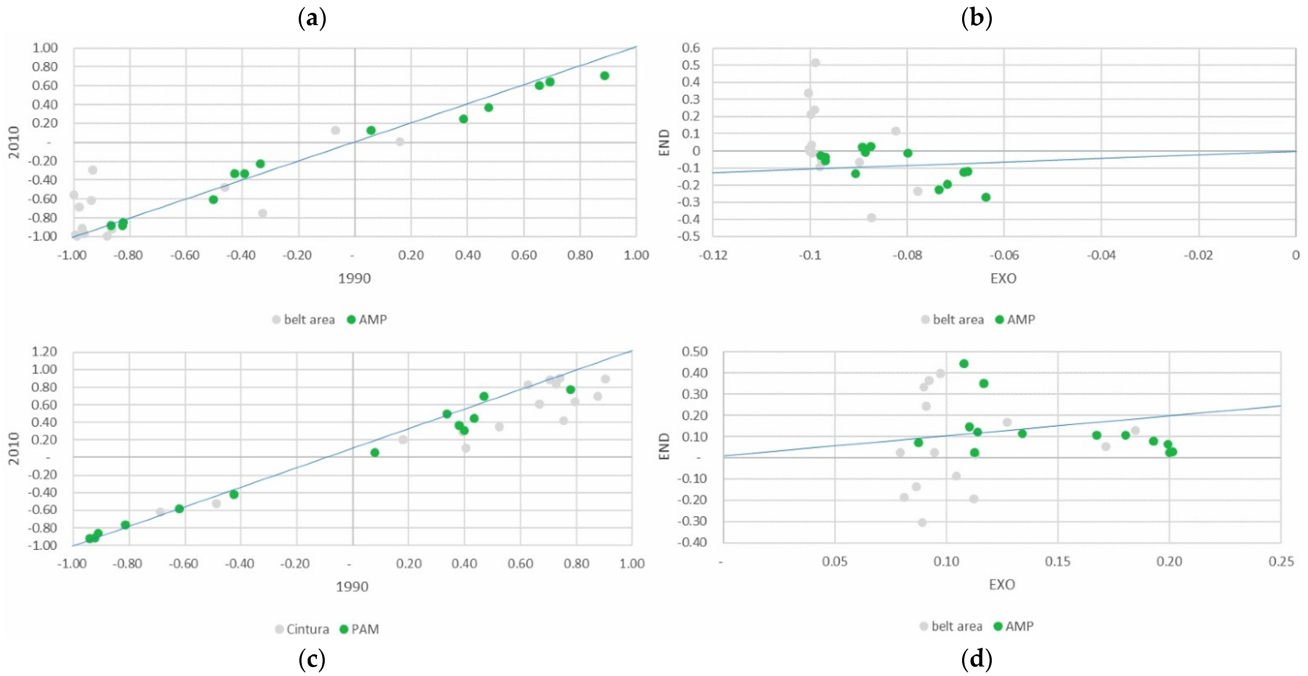
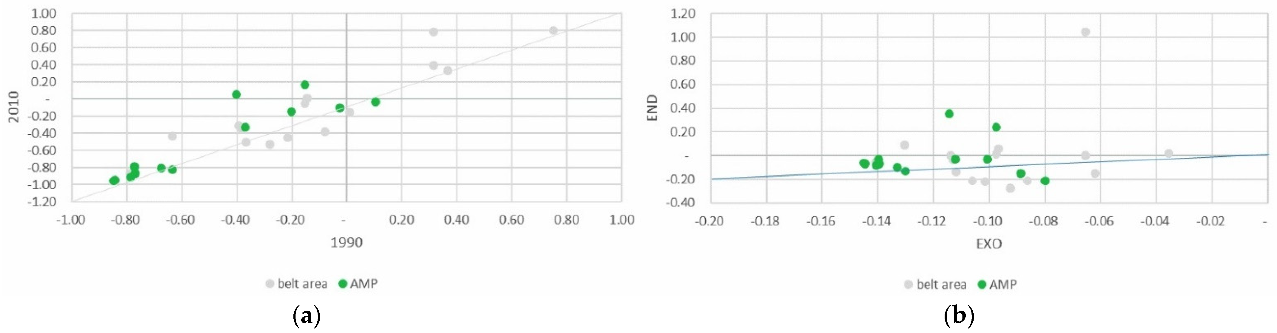
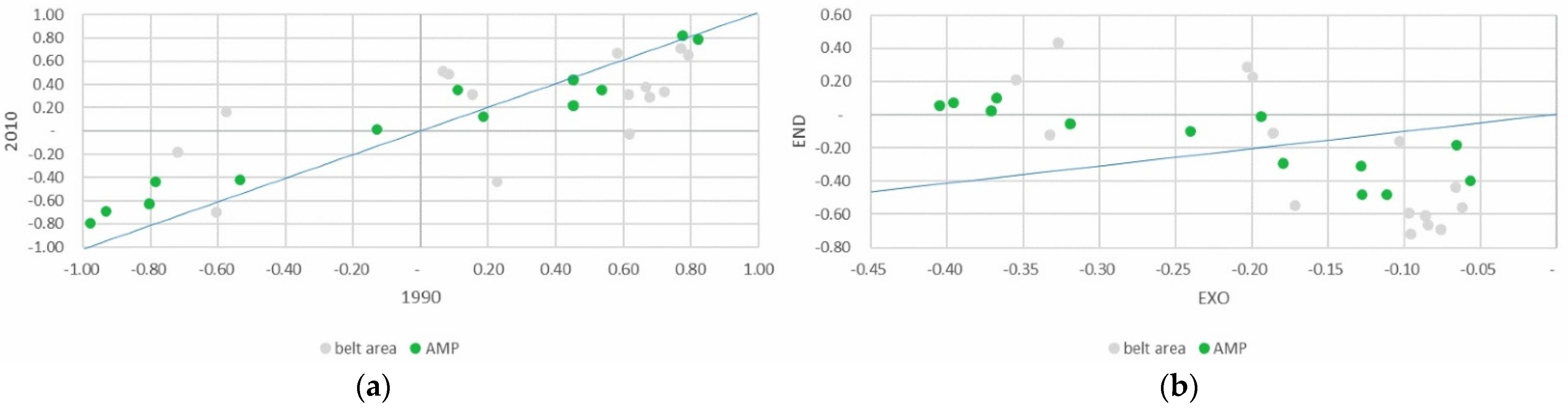
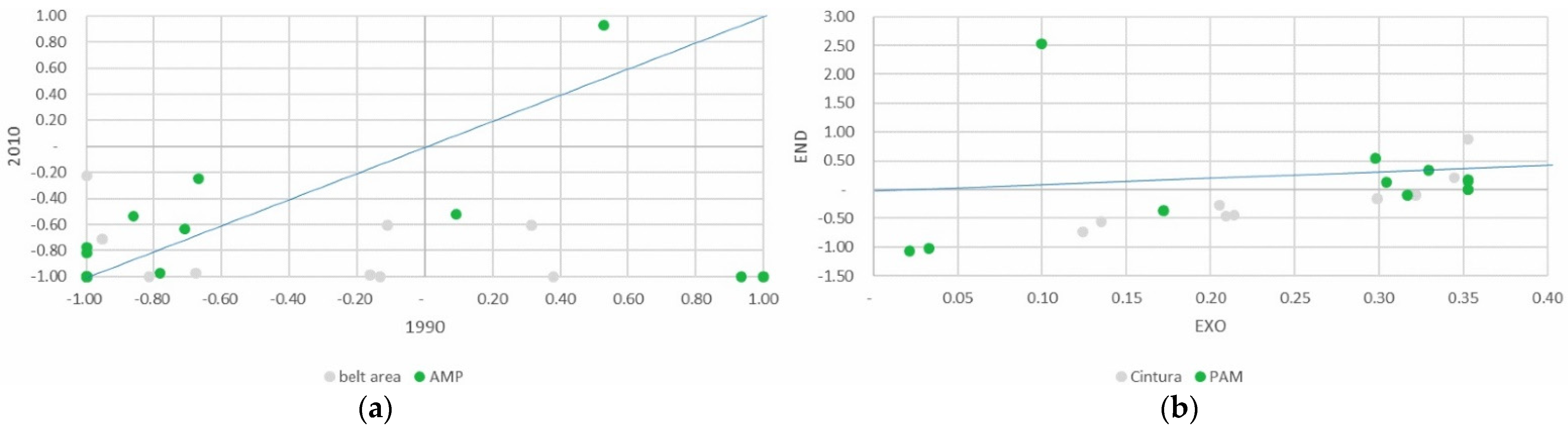
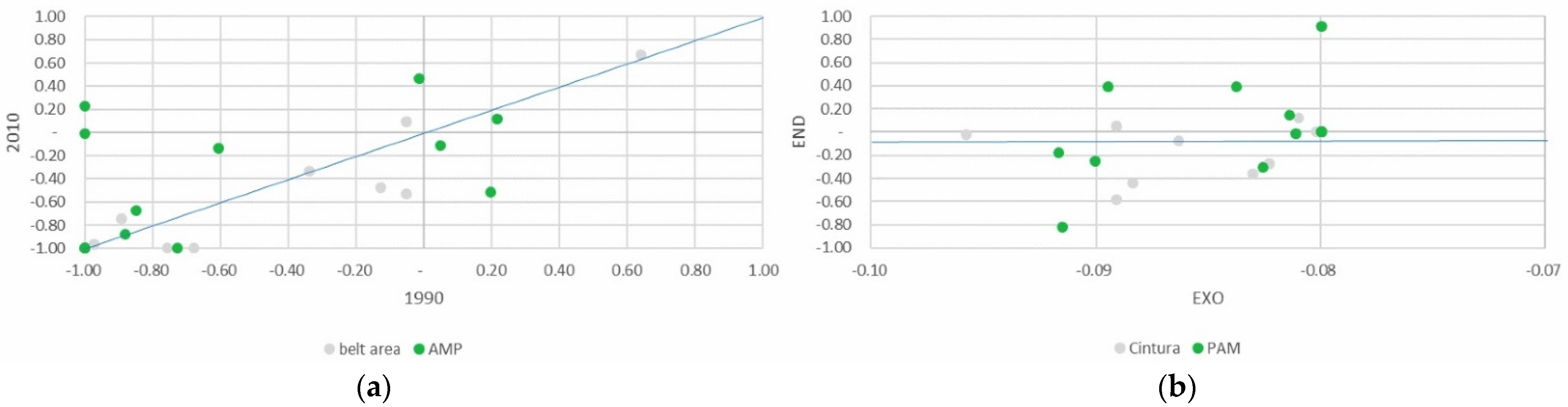
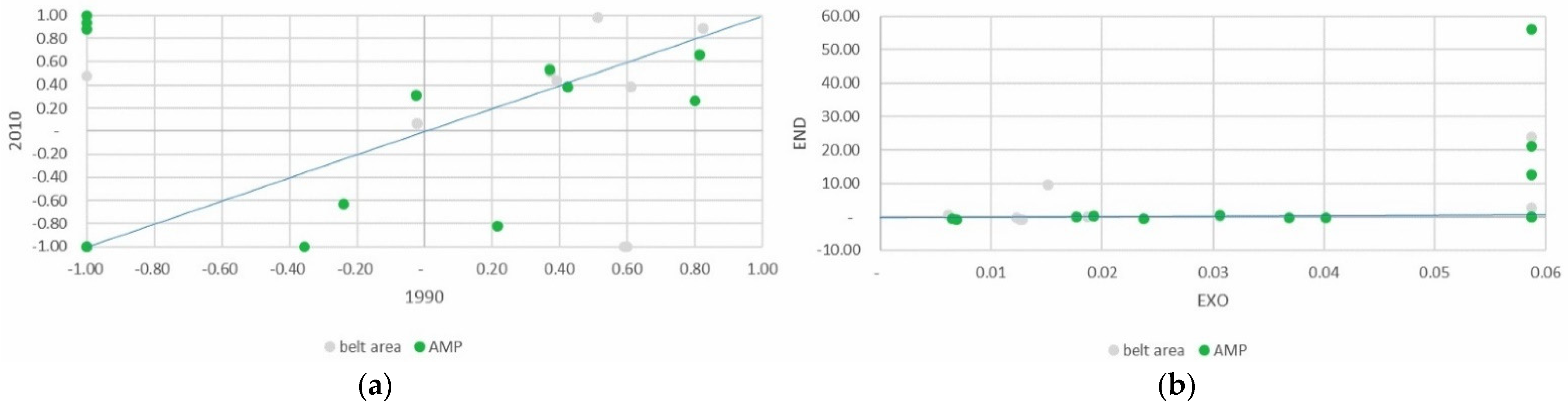
The results of the analyses can be better understood by visualizing them on a Cartesian plane, in which the
PSI values for the base year (and the values of the exogenous component of the
DPSI) are reported on the abscissa, while the final
PSI values (and those of the endogenous component of the
DPSI) are reported on the ordinate. The municipalities in which the
PSI value remains unchanged are on the diagonal line. In the municipalities to the left of the diagonal, the
PSI values have increased compared to the initial values shown in the abscissa, while in those to the right, the
PSI values have fallen (
Figure 2).
4. Discussion
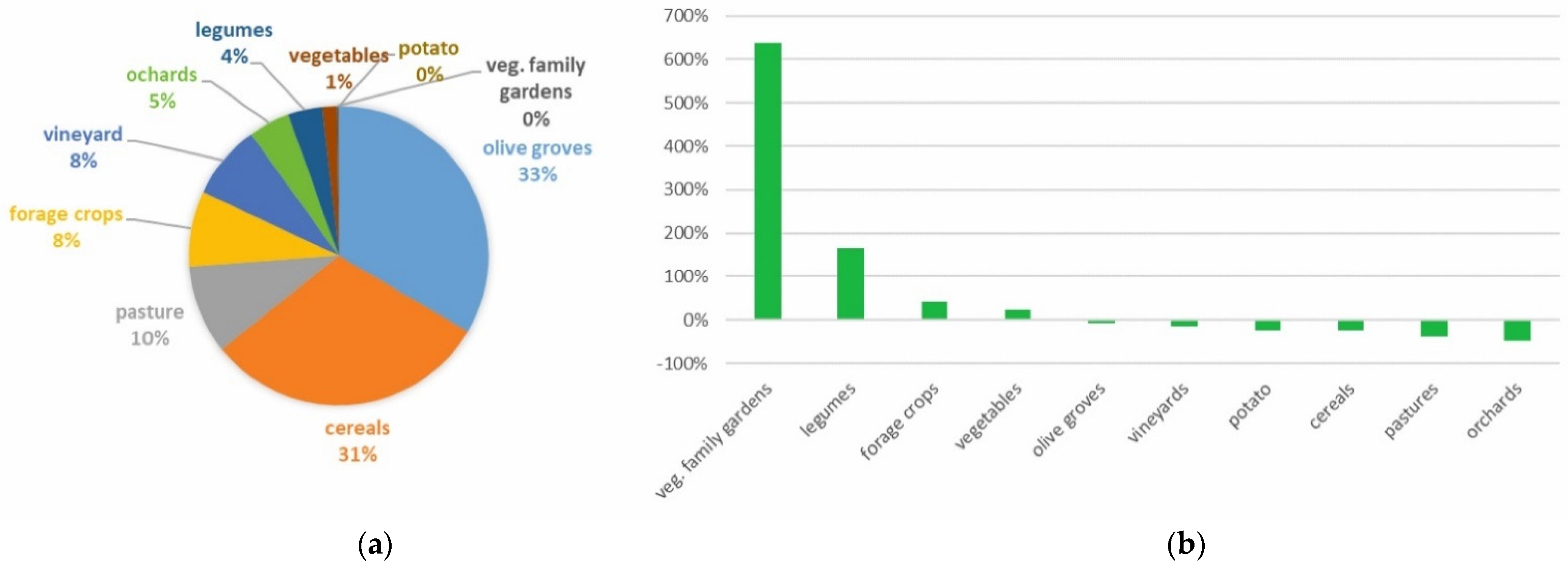
In general, the results of our research point to a range of different dynamics and attempts to revive these areas. The main changes comprise an increase in extensive farming, the abandonment of farmland, and the loss of traditional crops and agricultural landscapes driven by market forces and top-down regulations (more evident on the national side of SNP), both at international and regional scales. As Mose [
10] and Hammer et al. [
8] made clear, the plans for these areas are typically drafted with little involvement by local communities and even less from farmers (whose continued presence in the area and care for it is evidenced above all by the increase in family gardens). The priority objective in both the parks has been the conservation of natural heritage, in particular flora and fauna [
29], through various different LIFE programs. However, little work has been done to ensure the multifunctionality or sustainability of agriculture [
34,
35], the maintenance of agricultural heritage, or the agrobiodiversity of these areas [
36], as shown by the influence of the exogenous component in the production specialization/de-specialization processes in the area. In addition to measures aimed exclusively at maintaining material and immaterial values, the conservation of the agricultural heritage in both Sierra Nevada and Alta Murgia also requires other measures aimed at maintaining the uses and activities that have helped produce and sustain this heritage [
37,
38]. There are certain objectives of effective management that affect the areas both inside and outside the park, in which the needs and objectives of local communities could be better balanced with those of the private sector and public institutions (see meadows and pastures de-specialization). In order to facilitate this, different actors could be involved in different phases (and at different scales) of the planning of projects addressing the important issues facing these areas in the two parks (SNP and AMP), both of which have an important landscape corridor of enormous environmental, social, and cultural value [
39].
As Hammer et al. [
8] argue, both local institutions and private economic actors and farms play a crucial role, as does the local community, which can facilitate or obstruct the implementation of the programming [
40]. Furthermore, the action of individual stakeholders is insufficient, and the establishment of a network system is vital. This can take different forms, which are the precondition not only for the particular forms of protection applied in these areas but also and in particular, for a reticular, participatory planning approach to regional development [
41]. Another important aspect is the way in which differing, sometimes conflicting, objectives are reconciled, especially when it comes to promoting local products, in our cases, mainly cattle and sheep at SNP and legumes at AMP. This may require applications for product approval from below, usually from the manufacturers, those most interested in ensuring the product is a success. It may also involve park management and the regional government. These interventions can help improve and add value to traditional, high-quality local products [
42]. Official recognition of a product in line with a series of quality principles can provide a huge boost for its brand image, leading to an increase in its production, as happened with the Altamura lentils grown in the Alta Murgia area. This was achieved thanks to the determination of a consortium established by local farmers for the specific purpose of obtaining official recognition and protected status for the Altamura Lentil, which was eventually awarded a Protected Geographical Indication (PGI). This lentil, traditionally considered a product of the family agricultural economy, experienced many ups and downs until the large-scale abandonment of the countryside in the 1970s. It was only fully recovered in the early 2000s thanks to the interest of local farmers, who realized its value as an emblem of the agricultural, historical, cultural, and food heritage of the entire production area. Sierra Nevada, just like Alta Murgia, has a number of officially recognized high-quality products. A few municipalities fall within the area covered by the Protected Designation of Origin for Granada Wines (mostly in the belt area), which has contributed to maintaining this traditional cultivation system in the Sierra Nevada Natural Park and its surrounding areas. There is also the ham produced in the high-mountain village of Trevélez and other predefined municipalities (PGI Jamón de Trevélez). It has a slightly different status in that the territorial quality mark only covers the ham production process, and the pigs do not have to have been reared in the area (as evidenced by the de-specialization in pig production) (You can see:
https://www.mapa.gob.es/es/food/topics/differentiated-quality/dop-igp/jamon/IGP_JamonTrevelez.aspx, accessed on 2 June 2022). In the Sierra Nevada National Park, the pasture ecosystems at high altitudes now cover a much larger area due to the intense focus on conserving scarce ecosystems, biodiversity, and rare species of flora and fauna. Currently, 76.4% of the area of the national park is for restricted use only [
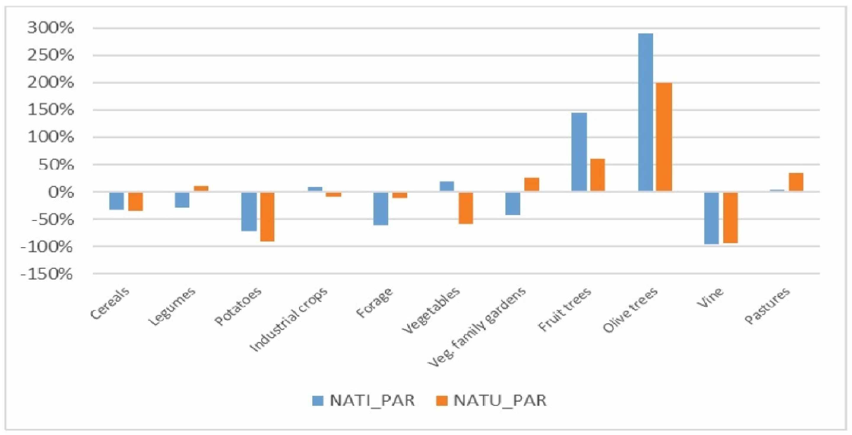
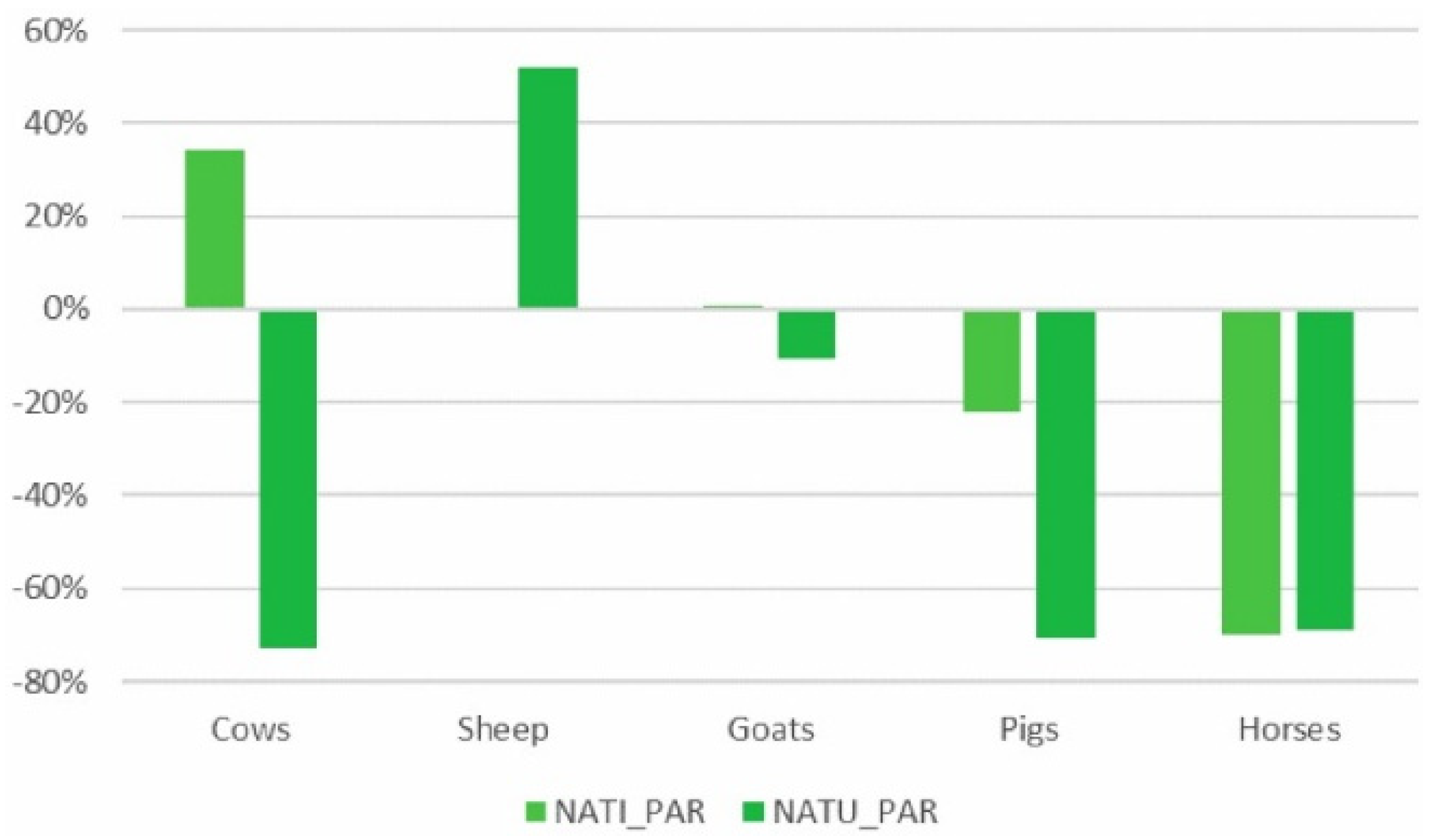
29]. These restricted uses are partly respon sible for the de-specialization of traditional farming activities (potatoes, cereals, and transhumant grazing) in the high mountain areas. The only activity with an endogenous component is sheep rearing, in which there is specialization in two municipalities associated with the recovery and enhancement of traditional local cheeses.
Similarly, in the Alta Murgia National Park, the territory within the park has several characteristic environments of extraordinary value on a national scale. Many of these have undergone significant transformations over time due to a range of anthropic factors. These include agricultural and pastoral activities, which have played a fundamental role in modifying their structure at both specific and ecosystem levels [
31,
43]. As transhumant pastoralism became less and less profitable in the Alta Murgia area, more space was devoted to agriculture, grazing, and arable land. In more recent times, the cultivation of more profitable crops such as grapes, olives, and almonds has been extended, contributing to land transformation and the demographic and economic development of the major municipalities [
31]. At present, over half the total area is devoted to agriculture with a strong prevalence of arable land, while the remaining part includes wooded areas and semi-natural environments. In particular, especially in recent years, there has been a trend towards the intensification of agriculture in the most fertile areas of the park, while the less productive ones are at risk of abandonment. The greatest decline has been in grazing areas, with some exceptions in municipalities with a strong historical tradition in the cultivation of grapes and olives, especially in the pre-Adriatic Murgian area [
42]. This has created a complex territorial system with pronounced differences between the north and south of the AMP and uncultivated areas in which, historically, there has been strong specialization in transhumant pastoralism, which has gradually declined over the last few decades. The decline in this activity has left its mark on the landscape in terms of the reduction in grazing land and an increase in steppe areas with a very small population, confirming the results regarding de-specialization in meadows and pastures as well as in sheep farming.
As happened in Spain, market forces have helped transform agriculture in the Murgia area, with a clear shift from extensive to intensive agriculture (see the specialization in cereals and olive trees), as part of the modernist thrust of the green revolution promoted during the first two decades of the Common Agricultural Policy. This excessive specialization in certain crops lies at the heart of many of the de-specialization processes (especially in cereals) observed over the study period. The intensive removal of stones before the establishment of the park enabled the transformation of about 80% of the pseudo-Mediterranean steppe (a Site of Community Importance of AMP) into cereal crops, a process encouraged by the economic incentives offered by the original CAP, as noted above, and also by the maintenance of a sectoral approach in its more recent editions.
In the Sierra Nevada Natural Park, the permitted land uses are less tightly regulated, which means that traditional crops such as olive trees or vineyards are more likely to be maintained. These peripheral, less protected areas have also hosted an increase in new, more profitable crops, such as organic vegetables and tropical fruits. Having said that, the trend towards crop/species de-specialization revealed by the analysis could indicate an incipient reorganization of both parks towards more extensive, more multifunctional forms of farming. Changes in this direction could be reconciled with the protection of biodiversity and the landscape, especially in the most vulnerable areas and those most exposed to local, national, and international economic forces. To this end, the park authorities could play a key role in reconciling management, protection objectives, and territorial development ones, carrying out the mission assigned to them and favoring the protection and development of the surrounding areas as well. It can also be viewed as a dynamic “living landscape” (as also declared by the Council of Europe [
44]) in which a diverse range of economic activities (agriculture, tourism, crafts, education, culture) should be carried out and better integrated, with support from “landscape policies”. This will require strategic cooperation between local and central authorities in line with their specific needs.
As in the case of the Alta Murgia National Park, the current situation in the national and natural parks in the Sierra Nevada is the culmination of a process of degradation of an “evolved” farming system [
45] that remained more or less unchanged throughout the 19th century and the first half of the 20th century, before entering a period of sharp decline from the 1950s onwards after large-scale emigration of the area’s population to more industrialized urban areas. Prior to this exodus, the traditional farming system accommodated the increasing population by increasing the irrigated area on the peripheral terraces in the traditional valley areas and by recovering some of the abandoned irrigation channels. In summer, livestock was taken to graze at high altitudes above 1500 m, and irrigation was installed for the cultivation of barley, rye, and potatoes. In this way, irrigated polyculture and rainfed cultivation of cereals, vines, fig trees, and almond trees coexisted with stable forms of livestock farming, in which the farmer reared sheep, goats, and cattle, while also growing a few crops. In other parts of the region, sheep were reared by transhumance, in which the shepherd was often traveling with his flock and could not, therefore, grow crops. In this way, a unique system peculiar to the Sierra Nevada evolved. Bosque and Ferrer [
46] described it as a “peasant mountain” farming system, based essentially on Mediterranean polyculture farming, which was very different from the farming systems traditionally found in other mountainous areas of Spain [
47,
48].
In both parks, industrialization and the consequent rural exodus caused the break-up of this system to the extent that a lot of cultivated land was abandoned due to the impossibility of mechanizing and modernizing small farms in unfavorable areas in an increasingly global market. Cattle farming also declined due to a lack of labor. These problems were exacerbated by the disappearance of other sources of employment and income, such as mining or the paid work available outside the region for farmhands, who would travel around the country to harvest grain and other crops.
This caused a reduction in the number of farms, mainly in inland areas such as those of the two parks. It also brought about changes in their structure and production systems, with the disappearance of large numbers of smallholdings, which made way for larger, more intensive farms. The abandonment of marginal agricultural areas had serious territorial impacts such as the degradation of the environment, an increased risk of fire, and an increase in reforestation [
48]. Perhaps the worst side-effect of these changes was the increase in soil erosion, which had been controlled for centuries by the complex networks of water channels, which were well adapted to the terrain, and by careful, sustainable farming of the mountainsides [
29].
In this context, the complex, diverse Natural Area of Sierra Nevada (which encompasses both the natural and national parks) and its belt area has significant opportunities, in addition to those already mentioned [
49]. The same applies to the Alta Murgia National Park. These opportunities include shifts in consumer demand towards local, handmade, and/or organic products, especially considering that park status could be used as a mark of distinction in terms of the quality and origin of these products while also taking advantage of the growing number of tourists who choose to visit the area. There is also the ancient network of water channels and the associated “careo” system, which are not only a very powerful feature of cultural identity and a unique tourist attraction but also an essential means of water distribution that maintains the landscapes of irrigated polyculture in terraces, the feature most valued by visitors to the area [
50,
51]. The multifunctionality of these agroecosystems has been institutionally consolidated, and their other inherent functions (environmental, aesthetic, recreational, etc.) are now officially recognized. As a result, specific grants and subsidies are now available, for example, from the CAP [
52,
53], which remunerates the non-commercial functions of the agricultural activities that sustain these ecosystems [
54].
However, these traditional landscapes are also under threat from capital-intensive greenhouse forms of agriculture, which produce high returns and high levels of income and employment in their local area, especially on the fringes of SNP. Unfortunately, they are also a source of negative social and ecosystem externalities [
55,
56]. Although greenhouse farming has spread a “sea of plastic” along Spain’s Mediterranean coast, in both Granada and Almeria provinces, it has not been an issue in the Sierra Nevada until quite recently. In the Natural Park Planning Regulations, greenhouses are prohibited above 900 m of altitude due to their environmental and landscape impacts. Those breaking this rule could be fined by the regional administration. In spite of this, they are becoming increasingly common inside the natural park. This is because this form of agriculture is highly profitable, making it possible for companies located on the coast to accept any fines imposed on them as if they were production costs. Greenhouses are also popular with local farmers based in the natural park, above all because they protect their crops from hail damage. They are also welcomed for the jobs they create [
57,
58] and have received the backing of the far-right political party (VOX), which passed a motion in the Andalusian Regional Parliament calling for the abolition of the fines imposed on greenhouse farming [
59]. This has given rise to a conflict between the conservationist interests defended by the managers of the Sierra Nevada Natural Park, protected by current regulations, and the economic interests of the intensive producers from the coast. Many of these producers are from Almeria and Murcia, where for 4–5 months in the summer it is too hot to grow vegetables on the Mediterranean coast. They can circumvent this problem by building greenhouses in cooler, inland mountain areas to which they can move their intensive production in the summer months. These are often protected areas [
39,
60]. The park authorities have proposed a number of alternatives to these farmers. These include broadening the cover provided by agricultural insurance, using temporary, removable protection systems in situations of climatic risk, or replacing intensive crops (cherry tomato) with other high-quality crops that are better adapted to this area, such as the “snowflake” potato.
In both parks, the LEADER approach has also made a significant contribution to the rise of rural tourism [
61,
62,
63,
64,
65]. In the Spanish case, associated activities are particularly popular on the southern side of the mountain range (known as the Alpujarra), where tourism is the main source of income in many municipalities [
66,
67]. This has led to the reactivation of handicrafts, textiles, and ceramics, as well as to the creation of high-quality local food products. The rise in rural tourism as an additional source of income or business activity has allowed many locals to continue farming on a part-time basis with the support of their families. This has enabled the survival of some farms that might otherwise have disappeared. Farming associations and cooperatives are also playing an increasingly important role, above all in the commercialization of agricultural products. This is a new, innovative practice that was almost non-existent prior to the implementation of the aforementioned European programs [
68]. However, the tourism sector plays a fairly weak role in the Alta Murgia area with quite low numbers and short stays. Short-stay tourism could be viewed as beneficial in terms of sustainability and is often a typical feature of agritourism [
69]. The aim should therefore be to increase the number of tourists visiting the area rather than trying to extend their stays, as this could become a new paradigm for rural development [
70]. The area is characterized by a weak service infrastructure (tourist accommodation, internal soft mobility), especially for tourism that can enhance the resources of the rural landscape. Although the municipalities in this area have a strong tradition in agricultural production, excellent agri-food chains (linked to durum wheat, milk, extra virgin olive oil, and wine, internationally known) and interesting features of the rural landscape (such as typical dwellings that bear witness to the transformations that have taken place in this area), this territorial heritage is not at all valued. As expressly stated in the plan, the area’s strong rural vocation has often acted as a brake on new forms of tourism when it could potentially be a positive factor in their development, linked above all to the enhancement of rural culture and customs and traditional local gastronomy. This explains why there are few high-quality local products and poor connections between agriculture and tourism, with a view to promoting multifunctionality and alternative sources of income that can supplement the income from farming.
An important rethinking of these areas is therefore required, which merges the concept of landscape with the extraordinary wealth and complexity of these rural areas. This should not be limited to the purely legislative sphere and should also recognize their cultural and identity values with greater involvement of the local communities through the activation of participation processes [
71], bearing in mind that the management of natural spaces and the development of rural areas cannot be regarded as separate questions [
71] and instead must be viewed as a single, common issue.
5. Conclusions
Protected natural areas in Europe today are facing very complex, highly diverse challenges, which prevent us from obtaining a generalized picture. This is due both to their progressive growth in terms of number and size and to the variety of categories and typologies that have emerged with profound regional differences. This is why in this study of two emblematic cases in Spain and Italy, an in-depth dynamic analysis was required. To this end, we applied a specific indicator (the Production Specialization Index) which was capable of detecting trends in farming specialization over time (as regards which crops were cultivated and which livestock species were reared). This indicator enabled us to identify local dynamics by making comparisons between the areas inside the parks and the belt areas surrounding them, so highlighting the relationships between the protected area, crop specialization, and the development objectives connecting farmers with the landscape and its economic potential. The application of this indicator produced interesting results, which were analyzed here in depth with the aid of additional sources, offering useful data about specific areas of the parks.
An interesting aspect that emerged in both parks was the importance of a regulatory framework at different levels (from the international level to regional and local plans). This is an essential prerequisite for the functioning of protected areas, such as natural parks, in which a series of objectives and operating rules must be established.
In both parks, the plans try to reconcile the protection of biodiversity and the landscape with the economic growth objectives of the areas concerned. This requires ever greater efforts in the management of rural resources and greater support from the different public administrations so as to enable the parks to carry out the mission assigned to them, in this way enhancing the protection and development of the surrounding territories. In both cases, the park areas are the result of internal and external forces that have played a fundamental role in the efforts to improve and promote the local resources that form part of the historical and cultural heritage of these areas. These programs are often aimed at boosting the local economy, especially by fomenting tourism, although the links between agriculture and local products remain weak.
The results obtained only partially confirm the resurgence of these rural areas. In both parks, a tendency towards extensification was observed in certain specific crops and species because they are more profitable and/or are considered to be of higher quality. In other cases, there is a risk of traditional crops and agricultural landscapes being abandoned and lost. Traditional landscapes are also threatened by the emergence of capital-intensive forms of agriculture. In both cases, greater, more effective involvement of local communities and farmers is required in the planning. In areas where the regulation of uses is less strict, traditional crops such as olive trees, vineyards, and legumes, or husbandry, such as sheep and goats, tend to be maintained.
In both parks, the conservation of natural heritage has been the priority objective through various programs and ongoing interventions. The actions aimed at promoting the multifunctionality or sustainability of agriculture, the maintenance of the agricultural heritage, and the agrobiodiversity of these areas have been less successful. Therefore, as emerged in our analysis, the various protection objectives should include the conservation of the area’s agricultural heritage, as well as measures aimed at protecting the tangible and intangible values, uses, and activities that have produced and reproduced this “rural cultural” heritage over time.
The cases analyzed present various similarities in aspects such as the need for greater local participation in planning and decision-making and the need to enhance the natural and cultural heritage and strengthen the connections between territories and economic activities. The two natural areas would also benefit from a wider range of high-quality local products, which at present tend to be concentrated in a few municipalities within specific geographical areas of Protected Designation of Origin, often promoted by local consortia.
In fact, in both the Sierra Nevada and the Alta Murgia parks, there is significant potential for the further enhancement of quality products, thanks to the support and the communication role played by the parks. In this way, the quality image of these products is bolstered by their natural origin inside a protected area, and they can also benefit from the growing number of tourists. There is also potential for the enhancement of agricultural landscapes and the multifunctionality of the agroecosystem (park areas and those nearby). This means recognizing other functions, in addition to environmental protection, which improve the quality of life of the communities.
In both cases, naturbanization processes can be observed. The demographic growth in the Sierra Nevada Natural Area, which generally confirms this process, is due, in the three areas considered, to an increase in the population in a few municipalities whose demographic and economic dynamics are determined by the fact that they are part of the metropolitan area of Granada. This behavior masks the population losses recorded in most of the small, mountainous municipalities that make up these spaces. This situation is more severe in the national park than in the natural park and also affects the neighboring area. Naturbanization is more evident in the AMP, where both internal and external municipalities show general growth dynamics (with some exceptions in two smaller internal municipalities). In this case, the metropolitan area of Bari plays a strong role in this process. These findings highlight the need to investigate these processes of naturbanization of protected spaces in much greater depth.
In general, within the context of growing interest in protected areas and parks, it is essential that their economic growth objectives be closely interlinked with those of sustainable development. Farm management should be oriented towards a relational, dynamic approach to enhance the territories involved. This will require a multifunctional approach and participatory planning based on cooperation between all the different stakeholders and interested parties. This requires specific interventions at an economic, social, institutional, and regulatory level, with a more in-depth investigation of the internal dynamics behind the different management models and of the relationships between the different tiers responsible for managing regional development.
National parks, thanks to their enormous natural, cultural, agricultural, and social heritage, can act as natural laboratories for testing and evaluating policies for local, community-led, sustainable development based on the endogenous resources of the region while also becoming “living landscapes” in which a range of business activities (agriculture, tourism, handicraft, education, culture) can be carried out in a combined, integrated way.
This is especially true in the wake of the COVID-19 pandemic. In both Spain and Italy, research has shown that COVID-19 has slowed down the processes of demographic decline in the rural world and, in some cases, even reversed it [
24,
72,
73]. This would explain the sharp increase in house purchases in rural areas [
74,
75,
76]. The pandemic has also accelerated the growth of specific forms of tourism, and this has highlighted new ways in which societies are looking at rural tourism, which is increasingly diversified and seems strongly linked to human health and safety. In this way, it expresses its potential for human well-being and for the resilience of rural areas [
77].
A possible line of research would be to try to assess the impact of the COVID-19 pandemic and whether new needs, strategies, and solutions have arisen for these areas. Finally, our research was centered, above all, on a quantitative methodology that combined different sources to perform an in-depth analysis to help understand and interpret the trends at a local level. However, in future developments of this research, an important step forward would be to combine these quantitative data with qualitative analysis, including the views and perceptions of local residents, park managers, entrepreneurs, and other stakeholders. Future lines of research will require constantly updated data at appropriate territorial scales in order to be able to monitor the situation and make the forecasts necessary for drawing up the area strategy. In particular, we are referring to Agrarian Censuses, the last of which were published about 10 years ago in both countries. The lack of more recent information makes it difficult to know and understand the changes that have been taking place in recent years and to assess the impact of the protection and development mechanisms being applied within the different parks.


 ,
, 


