Landscape Strategy-Making and Collaboration. The Hills of Northern Mors, Denmark; A Case of Changing Focus and Scale


Section for Landscape Architecture and Planning, Department of Geosciences and Natural Resource Management, University of Copenhagen, 1958 Frederiksberg C, Denmark
*
Author to whom correspondence should be addressed.
Land 2020, 9(6), 189; https://0-doi-org.brum.beds.ac.uk/10.3390/land9060189
Submission received: 4 May 2020
/
Revised: 26 May 2020
/
Accepted: 1 June 2020
/
Published: 9 June 2020
(This article belongs to the Special Issue Rural Landscapes - Challenges and Solutions to Landscape Governance)
Abstract
:This paper focuses on a three-year rural landscape strategy-making process, which was driven by a Danish municipality and involved a large number of stakeholders. The project was part of an action research program aimed at developing new approaches to collaborative landscape planning. Gaining experiences with such approaches was part of this aim. During the course of the project, the focus and scale of the strategy changed significantly. The process developed in interesting ways in respect to three dimensions of collaborative landscape planning: collaboration, scale, and public goods. After a brief review of the three dimensions and their links to landscape planning, the case story is unfolded in three sections: (1) The planning process, (2) the process outcome (the strategy), and (3) the aftermath in terms of critical reflections from participating planners and local stakeholders. The process and outcome of the landscape strategy-making process is discussed in the context of collaboration, scale, and public goods, including a brief outline of the lessons learned.
1. Introduction
The participatory and collaborative approaches to environmental planning and policy have gained currency in recent decades for several reasons. One such reason is the increased complexity in the change patterns with many different and intersecting drivers functioning at different scales and political-administrative levels––the so-called ‘politics of scale’ [1]. Also new approaches to democracy and inclusion should be included as background to the growing interest in collaborative approaches [2] together with a simple need for communicative interaction when many interests and stakeholders are involved [3]. Furthermore, the call for policy integration, which was put forward by the Brundtland Commission [4] and written into EU treaties, requires collaboration and the inclusion of a wide range of stakeholders and public sectors [5,6]. Finally, the different meanings and values associated with nature and landscape [7,8] can be added as an argument for involving different kinds of stakeholders.
The policy domain of spatial planning has a history of adopting participatory and collaborative approaches, which represent a way of framing conflict management and promoting desired future changes, including guiding place making processes [9,10]. Spatial planning involves the provision of public goods (sometimes termed externalities) and the distribution of land resources [11]. It is about the effective and fair use of land resources based on a combination of professional expertise and social interaction or, more generally, about linking knowledge to action [12], which in most cases involves a variety of actors. Spatial planning solutions often evolve through the linking of professional analysis and ideas with stakeholders’ knowledge and interests.
When collaborative processes are set in motion, they may go different directions. Problems may be re-defined and even the starting goal may be questioned. Establishing collaborative processes then implies that public authorities must relax their ambition to control the process and unpredictable outcomes must be anticipated. However, top-down processes with no substantial involvement of stakeholders on the other hand may lack ownership to the goals and shared understandings of the underlying problems and may therefore also lack effectiveness and predictability [10,13].
In this article, we focus on rural landscape planning from two perspectives: collaboration and the protection and promotion of public goods, and we attempt to combine new ideas of landscape approaches with spatial planning using a framework for ‘landscape strategy making’ described elsewhere in detail by two of the authors of this paper [14,15]. A recent Danish landscape strategy making process in which the authors of this paper participated as part of an action research program is used as a case study. The planning outcomes are discussed within the context of recent literature on approaches to land use policy and landscape governance. We address the following three research questions: (1) What happens to the ‘ownership’ of the strategy if the initial objectives change—and how do participation and collaboration dynamics affect and, in turn, how are they affected by the initial overall focus and perspective? (2) What is the significance of scale when the planning scope applies a collaborative landscape approach to rural development? (3) How is systematized and expert-based knowledge combined with local stakeholders’ values and what effect does it have on public goods?
The case study concerns a collaborative landscape strategy-making project for a rural Danish coastal landscape involving municipal planners and local stakeholders over a three-year period. During this process the aims and scale of the project changed significantly from a focus on enhancements of a local, intensive agricultural landscape to a spatial strategy for a regional coastal landscape.
2. Collaboration and Public Goods in Rural Landscape Planning
According to the European Landscape Convention (ELC), landscape policy and planning involves protecting, managing, enhancing, restoring, or creating landscapes [16] (Art.1). The ELC concerns all landscapes from high priority national parks to everyday local landscapes. The convention calls for public awareness of landscape values, recognition of landscape as a significant component of people’s surroundings in relevant legislation, public participation in policy and planning, and the integration of sectoral policies and plans using the unifying dimension of the concept of landscape. In the preamble, there are even a call for ‘a true landscape democracy’. In this way, the ELC places landscape in the center of multiple interfaces [17]. Our focus in this paper are on three of these interfaces as outlined below.
The first is about participation and the interaction of different actors involved in landscape policy and planning [18]. Public agencies and landowners are the key actors. Public agencies hold the legal decision-making power, but are also faced with limits to their decision-making, which is why they may depend on other actors in order to implement their policies. Landowners (farmers and other primary landscape managers) are key actors simply because they own the land. Through ownership, they control the land, but it is also through their ownership or user rights that they can be targeted by agri-environmental policies and rural land-use regulations. Furthermore, local communities are important actors as they represent common values and shared experiences and hold various resources, which may be activated in the planning process. Whereas the relationship between the public agency (municipalities, regional bodies, and state agencies) and landowners is most often characterized by a conflict between individual rights and public goods, the relationship between communities and the public agency typically involves managing or enhancing landscape features, i.e., place making [19]. Participation is often linked to democracy and is associated with the right to have a voice when one’s surroundings are impacted by public decisions. According to Arler [20], at least three sets of, often conflicting, values are usually associated with democracy: personal freedom and self-determination, co-determination, and participation in common affairs, and objectivity and impartiality. The first refers to freedom for individuals to make decisions in relation to their own life conditions. Co-determination and participation involve the right to be heard, vote, and have one’s interests taken into consideration in public decision-making. However, the value of co-determination is also connected to people’s engagement in processes of mutual learning and collective decision-making. The third set of values, objectivity and impartiality, concerns the core of the democratic decision-making process. Following Arler [20] (p. 7), the important principle here is that arguments (not power) put forward in open public debate, coupled with fair decision-making procedures, should determine the outcome of political decisions, and that these arguments should impartially address the public as a whole and not just one particular privileged section of it. This respect for arguments also includes a respect for expertise and knowledge.
Second, there is the way that local concerns and daily life are linked with ecological processes and human migration/traveling patterns at the regional scale. Landscape changes are caused, to a large extent, by decisions and actions taken on the individual farm, forest, or other rural property. However, it is the accumulated effects of these different practices at the landscape scale that determines the extent to which the landscape is attractive for walks, suitable for hunting, and angling, or rich in wildlife—to mention different aspects of landscape quality. Moreover, actions at the regional scale, for example, the creation of a regional walking route or large-scale habitat restoration, often provide more extensive opportunities and place local landscapes or sites on a tourist map or effectively contribute to socio-ecological resilience. Forman [21] (p. 514) characterizes this as the management paradox: “Our ability to affect the outcome is greater in a landscape, the probability of success is greater in a region”. Newig and Fritsch [22] further reflect on this dilemma. They summarize three arguments as to why common goods can be dealt with more effectively regionally rather than locally. First, because local participants may be less in favor of environmental action due to economic interests and because they do not recognize the impact of their own actions on the wider scale. Second, local governments may be more susceptible to lobbying by economic interests, and third, participants engaged in issues at higher spatial scales may have greater competency. On the other hand, Newig and Fritsch [22] highlight that a high local engagement (e.g., due to economic interests) is likely to lead to more ecologically rational outcomes than governance on higher spatial scales. This is due to the inclusion of local lay knowledge and the capacity of local groups to self-organize, and thus, better ensure social control, acceptance, and compliance [22].
Third, as planning is a process that links knowledge to action [12], the interface between local and experienced knowledge and external expertise (in respect to the landscape in question) becomes a critical dimension in landscape planning. What kinds of knowledge are needed? How are the different types of knowledge combined and translated into action?
Knowledge may be defined and classified in different ways. Healey [23] discusses systematized and practical/experiential knowledge, whereby the former is generated ‘through categorization and/or through argumentation, which connects concepts about causes and effects with systematized evidence about experiences’ [23] (p. 863). Environmental impact models of relationships between agricultural practices and environmental outcomes applied to the management of specific habitats are an example of this. Experiential knowledge refers to knowledge ‘gained through experience of daily life (in all kinds of contexts), and of task performance (often termed ‘practical knowledge’)’ [23] (p. 863). The history, meaning and value of the landscape in question and its places are examples of such knowledge. The inclusion and confrontation of systematized and practical knowledge can be organized in different ways, from simple meetings to more sophisticated dialogue. New insights and common understandings frequently evolve from such dialogue-based processes [15].
Seen together, the interfaces between landscape and social actions influences how effective a landscape planning process is in producing a plan with a broad ownership of the goals and other main components, which ultimately contributes to more attractive and well-functioning landscapes.
3. Materials and Methods
‘Landscape Futures’ was a nationwide action research program in Denmark that focused on novel planning and design solutions for the future of Danish rural landscapes. Action research was an important component of the program, in which academics in landscape ecology and planning participated actively in the projects with the double aim of contributing to the process with skills and knowledge, and subsequently reflecting and learning from the interactions and outcomes [24,25,26].
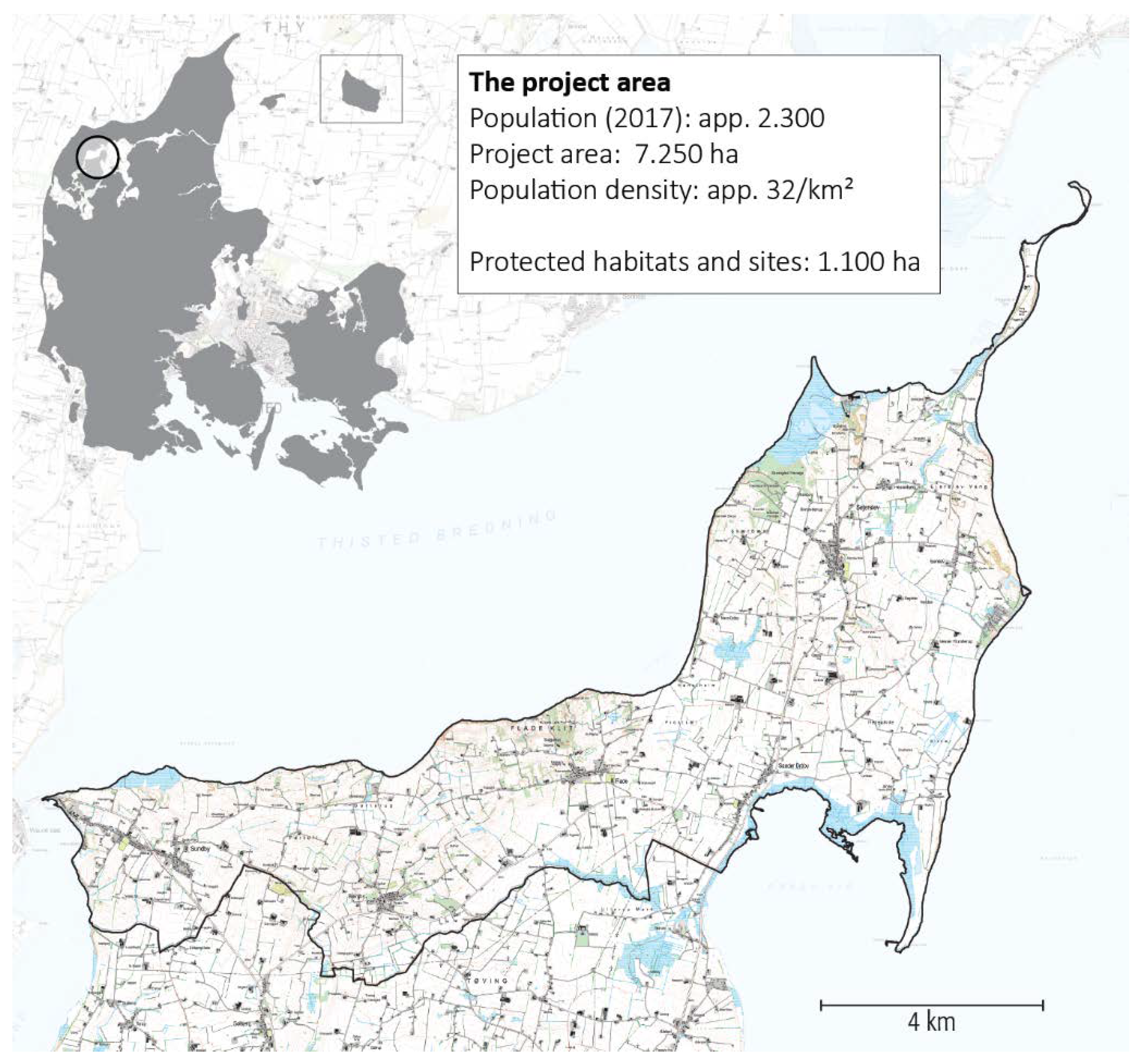
The program ran from 2013 to 2018 and consisted of 12 cases, all of which aimed to achieve a high level of dialogue and collaboration in order to address the new and complex challenge of designing future landscapes. One of the cases was located in Morsø Municipality, which is a rural municipality comprised primarily of the island, Mors, in the north-western part of Jutland (Figure 1). In 2017, Morsø Municipality approved a strategy for the northern part of Mors consisting of the following three components: overall spatial landscape plan, goals, and strategic projects. The strategy was developed in collaboration between Morsø Municipality, local citizens, and the University of Copenhagen, including the three authors of this article. However, the municipality had the formal project responsibility. The case studied can be viewed as being called ‘extreme’ or ‘deviant’ in the sense it informs about an unusual planning process in which both scale and content including aims changed. According to Flyvbjerg [27], such a case is useful to inform about a specific problematic characteristic of collaborative planning: the unpredictability of the outcome
The focus of the planning proposal was originally to create a holistic landscape strategy for the area around the villages of Sejerslev and Ejerslev (see Figure 2), which integrated mo-clay areas, wetlands, local recreational landscapes, and alternative housing forms in the open countryside. The mo-clay areas crop out several places on northern Mors forming spectacular bluffs along the coast with folded layers of ash from volcanic activity approximately 55 million years ago. Mo-clay is a diatomitic sediment, very rich in fossils. The Mors region is the only place in the world where this unique formation is visible and it is currently on UNESCO’s tentative list of candidates for World Heritage sites.
The key planning issues of the initial project description were habitats and biodiversity, housing, villages and local communities, and agriculture. In addition, the aim was to develop the landscape strategy with the involvement of local actors and citizens in collaboration with Morsø Municipality in order to achieve local ownership. The methodological framework used is described in Section 4 below. It was proposed that local strategy groups should draft a plan for the overall development of the landscape as well as concrete suggestions for future actions.
However, this was not how it ended. The final strategy turned out to be quite different. It became a landscape strategy for the unique costal landscape for a larger part of northern Mors rather than a strategy for a multifunctional landscape surrounding the villages of Sejerslev and Ejerslev. Tourism and the conservation of geological and scenic values became central themes together with nature conservation and rural development.
The landscape strategy process was organized in a way so a number of academics and professionals participated in the different events (besides conducting traditional landscape analyses and surveys based on semi-structured interviews), which where documented through notes and minutes.
Two years after the landscape strategy had been established, a two-hour group interview was conducted with three municipal planners and four citizens who had been actively involved. The interview was organized as a focus group, for which participants were carefully selected, and which was moderated by one of the authors of this paper [28]. The participants were given the opportunity to comment on a draft of this text.
The ‘results’ of the case study outlined in the following three sections concern process, formal outcomes, and ex-post reflections of the planning case.
4. The Strategy-Making Process
From the beginning, the process through which the strategy took shape was organized as a collaborative course of actions involving a farm survey, a series of ‘winter lectures’, an excursion, and a number of workshops (Table 1). Two important aims of the many events was the creation of interest in the future landscape of Northern Mors and the mobilization of knowledge and ideas following a framework for landscape strategy-making developed through a number of previous experimental planning projects [15]. The participating stakeholders were a heterogeneous group of municipal planners, museum staff, members of the local nature conservation association, and local residents including full-time and hobby farmers, village residents of different ages, and linked NGOs. We estimate that more than 200 people participated in one or more of the activities listed in Table 1.
The initial focus was on the two villages of Sejerslev and Ejerslev and the surrounding intensive agricultural landscape. A survey of 48 farmers revealed a clear interest in participating in collective projects such as land consolidation (62% were interested), collective plantings (70%), and participation in a common landscape plan (69%) [29]. During the initial stage, a workshop was held with participants from different offices at the municipal administration, the local museum, the tourist agency, and a few university academics in order to identify key issues from a public agency point of view.
The first public meeting with local stakeholders took place over two half days. On the first day, an excursion to the area opened the process with many stops and on-site discussions. On the second day, two experienced landscape planners from outside were invited to give their impression of the landscapes and the problems and potential. There was some confusion among the participants about what a landscape strategy was. A group of citizens questioned the size of the project area and argued for a substantial enlargement to include the coastline of Northern Mors all the way to Sundby in the west (see Figure 2). They claimed that this part—where they lived—was a natural part of Northern Mors and contained the same characteristic hilly landscape with exposed, spectacular bluffs as the initial project area. Their points were noted, but they got no principal agreement on expanding the project area from the municipal planners at this stage. The focus of the debate and the excursion stops concerned the original area and the intensive agricultural landscape. Key issues were tree plantings, opportunities for outdoor recreation, and enhancing the quality of the agricultural landscape in various ways. In addition, a general need for reallotment of fragmented agricultural holdings, promotion of future tourism, and regulation of mo-clay excavations were mentioned. It was agreed to create two groups of residents divided according to their interests regarding the different issues.
At the next meeting, two groups presented their initial ideas for a landscape strategy for Northern Mors based on the input from the first workshop. There was also a presentation of a somewhat similar bottom-up landscape strategy project that had been implemented ten years earlier in another part of the country as inspiration. Concerning the group presentations, one group concentrated on improved opportunities for outdoor recreation supplemented by ideas for new rural housing in connection with Sejerslev village and the creation of a new lake as part of a wetland restoration project. The other group presented an idea to establish a ‘narrative landscape’ in which recreational access and the provision of information about the cultural and natural history of the area were key issues. The creation of a ‘nature park’ was also proposed. The subsequent debate concentrated on the clear overlaps between the two presentations. No serious disagreements or conflicts emerged during the discussion. The mo-clay excavation activity was part of this discussion. The importance of jobs for the local community was emphasized, as were the clear impacts the excavation has on the landscape.
The next meeting, however, represented a clear turning point. The meeting was organized as a workshop focusing on overall visions with five presentations. Two presentations focused mainly on the original area with recreation, narratives, and specific sites of high value as the central themes. The remaining three presentations were coordinated and shared the same headline: ‘The Mors Hills—a narrative landscape’. All three presentations included a significantly enlarged project area and all focused on the spectacular coastline, its hilly landscape rich in geological and aesthetic values. The need to protect these landscapes against plans to expand the mo-clay excavation and the potential for tourism and rural development were the main themes, which formed the agenda for the subsequent discussions, and more importantly, the overall landscape strategy. Establishing a nature park, a UNESCO Geopark or Heritage Site was part of these three presentations and the implementation of a so-called ‘Nature conservation order’ to improve landscape protection was also emphasized.
Interestingly, none of the five presentations mentioned agriculture, and thus, the intensive agricultural landscape in the center of Northern Mors was no longer the central theme of the landscape strategy. A strategy group composed of interested residents was formed at the end of the meeting. Several of the residents who had been engaged in the first part of the process did not sign up for the strategy group and left the strategy process altogether.
Two months later, the strategy group had a meeting with municipal planers during which they presented a proposal, which formed the backbone of the final strategy. However, the meeting was also used to discuss two issues that had emerged. One was a proposal to erect a number of new, very tall (>150 m) wind turbines in the area. This project was proposed by a large energy company, but after a brief intense public debate, it was rejected by the municipal board. The second was put forward by the mo-clay excavation company, who suggested opening a new pit in an area that had just become part of the revised and expanded project area. The municipality supported the opening of the new pit and conflict over the future of mo-clay excavation was now part of the landscape strategy process. As discussed below, the municipality somehow changed their position on this.
After this meeting, the municipality took over the task of framing the landscape strategy document, which was partly based on the numerous presentations and meeting minutes and several informal contacts with members of the strategy group.
5. The Landscape Strategy for the Hills of Northern Mors
The vision for the northern part of Mors is to develop the area into a narrative landscape with the geology and mo-clay formation representing key focal points for housing, businesses, and tourism. The highlighted areas are characterized by outstanding nature, beautiful views, and active outdoor life. Six goals for the region were identified:
- Produce landscape and livelihood narratives.
- Recognize the great landscape values through designation as a special landscape, e.g., UNESCO World Heritage site, UNESCO Geopark, etc.
- Develop business related to tourism and niche agricultural production.
- Construct new recreational infrastructure and housing.
- Strengthen local communities regarding the values and management of the landscape.
- Develop a well-functioning and sustainable balance between conservation and development-oriented efforts.
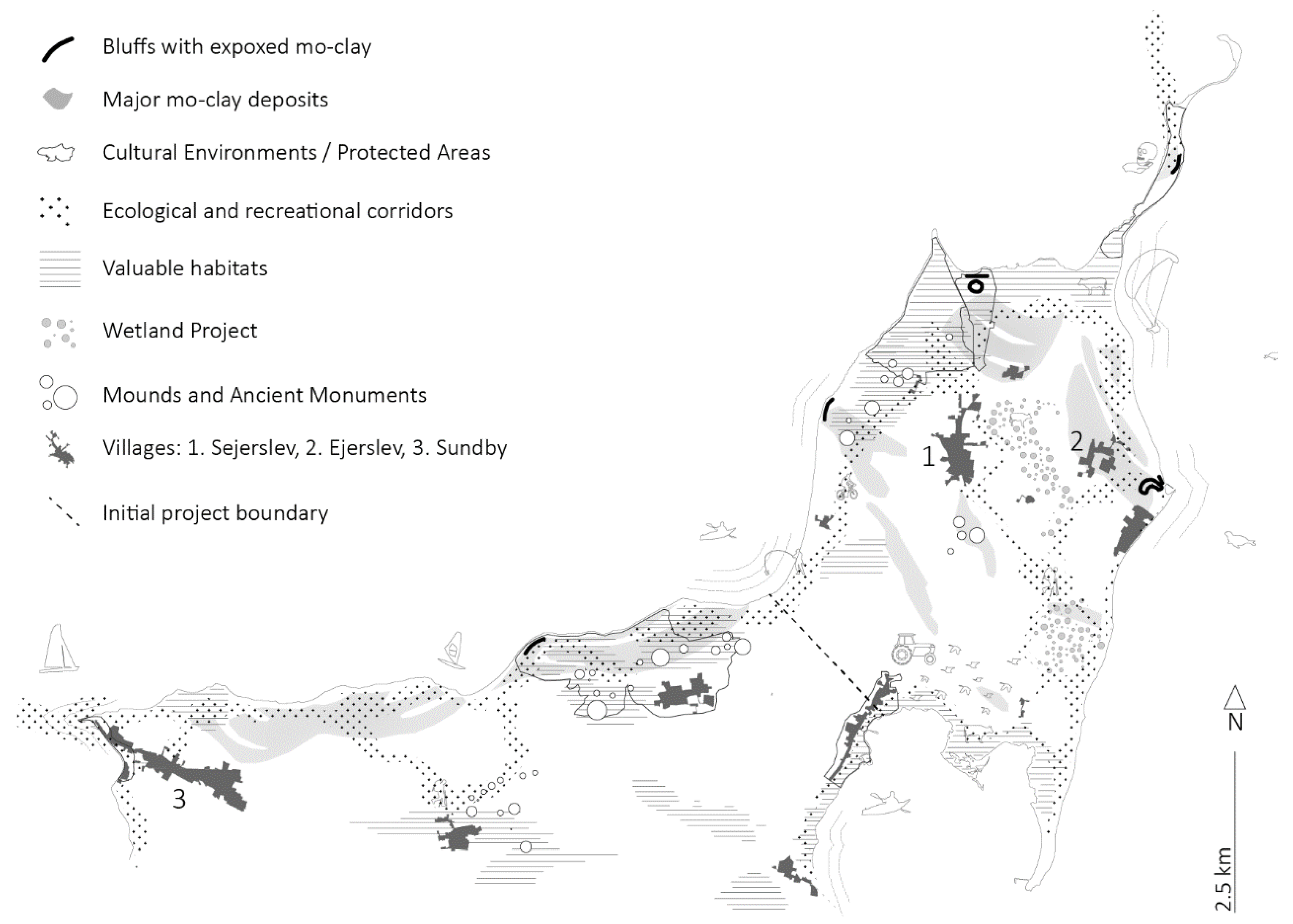
The spatial plan (see Figure 2) included in the strategy focuses on the coastal landscapes and how they form a pattern of hills. Cultural, scenic, and natural values are concentrated in these hilly areas. The plan also designated areas for wetland restoration and included the creation of a green corridor across the central part of Northern Mors from the mo-clay fossil museum in the northwest to the newly established marina at Ejerslev Harbour on the east coast
An important part of the strategy concerned the selection of specific initiatives that could achieve the objectives of the strategy. These strategic projects include improving recreational experiences in the mo-clay landscape, nature conservation, and nature management, and not least, story-telling regarding the landscape and mo-clay. A key element in the strategy is a corridor project linking Ejerslev Harbour and Skranderup Forest. This project was developed further in a Master’s thesis project to consist of a green belt of forest and semi-natural grasslands as well as a small village forest close to the village of Sejerslev [30]. The local residents were positive about the idea of establishing a 6-km long and approximately 60-meter wide green corridor, and it was subsequently included in the municipal plan.
After the strategy was approved, the municipal board decided to support the proposed conservation order preventing an opening of a new pit in the south western part and thereby changed position towards expansion of excavation pits.
6. Two Years after––Stakeholders’ View of the Process and the Strategy
To date, no ex-post evaluation of the landscape outcomes of the strategy has been made. The strategy was approved in 2017, but to be able to conduct a meaningful assessment of the landscape effects requires the passage of at least ten years. However, some ex-post information on the strategy has been provided. A focus group interview was organized by the participating academics from the University of Copenhagen (two of the authors of this paper) with the aim of obtaining information about how the various stakeholders who had actively participated in the process experienced the process and regarded the strategy.
Seven individuals were invited, all of whom participated:
- Four citizens; two who were actively involved from the start to the end (A and B); one who was rather committed in the beginning, but subsequently left the group (C) and one who was mainly engaged in the corridor project described above (D).
- Three municipal planners who were all actively involved at different levels in terms of leadership (E,F,G).
The main issues for discussion were sent to the participants beforehand. Two overall themes were investigated: (1) the strategy making process and the changes in scale and focus, and (2) the value of the strategy as a framework for the development of Northern Mors.
Different opinions were expressed concerning the expansion of the area and the new content, although these changes were never explicitly discussed or decided on during the process. These changes were something that happened because the proponents of an expanded project area were very active and able to present a series of convincing visions and ideas. Some of the residents who were mainly interested in the Sejerslev-Ejerslev area eventually left the process. One of them participated in the focus group interview (C) and expressed the following view of the process:
“I was very much against the project area being expanded, and I also left the working group. For me, it took a meeting or two [in the beginning before expansion was decided] for me to see the light and realize—oh my, there really are opportunities here, we really have the chance to affect this landscape. ... When half a year had passed—after many meetings and bus trips to look at things—we doubled in numbers [in the strategy group] and the focus on Sejerslev and Ejerslev disappeared, which I thought was bad. It may be that the other [the new more regional] focus is alright, but this was not where we started”.
Another resident (B) who came from outside the original project area and who argued, from the beginning, that the area should be expanded and have a greater focus on landscape conservation and problems with future excavation of mo-clay commented:
“If you are passionate about something and have some visions you want to pursue, you must be where the things are happening. The invitation from Mors municipality was very open—everyone was welcome. We never intended to reduce others’ opportunity to speak up. And I think that it was very important for the impact of the project that is was expanded”.
A third participant (A) who was engaged in the initial, more narrowly focused project agreed that the expanded area was good. However, he was not pleased with the process itself:
“It was a tremendous change because suddenly this new perspective came in. And it came in—seen from the original group’s point of view—as a very unusual form of communication, and this probably came as a shock for many of the locals who participated, and I felt sad that we were not able to maintain the local engagement. … We were (in the initial group) engaged in many exciting things, but many of these have come to life again including the corridor.”
Furthermore, the municipal planners had their own views on the changes, which were somewhat different from those of the residents. The technical director (E) of the municipality had seen the expansion coming at an early stage and was quite relaxed about it. As he said:
“In processes like these, it is very important that the municipality does not set up limitations. We are happy to help you [the residents] by promoting development. If there is no interest in our original idea, we accept what is coming up. Our agenda does not determine the direction of development”.
A senior planner who was also the formal project leader (F) was frustrated in the beginning, but also emphasized the dialogue dimension as being crucial.
“I remember that when we wrote the project description I was very excited about the idea of collectives and alternative forms of living. However, one thing is that I can sit in my office and think this is very interesting—we had been to the Netherlands and seen some very exiting projects—and despite this, I am very pleased that the dialogue approach wins in relation to what is meaningful to the ones who are engaged in this project. To be honest, there was a time when I thought, damn it, now they are taking the project away from me. But then I think that everyone has been the winner in this project.”
When it comes to the strategy and its potential to affect the Northern Mors landscape, there was considerable agreement that it was a good strategy among the focus group. Several used the wind turbine case as an example of how the strategy—even before it had been finalized—proved to be a good common platform for grassroots to resist a proposed project and eventually to convince the municipal board to drop the idea.
The expanded scale was emphasized by many including one of the residents (D) who mentioned that even if the south-western part did not belong to ‘Northern Mors’, it was good this area was included:
“When one reads the strategy, I can easily see that it is a well-connected landscape. That it is a good strategy because it is coherent, especially in relation to the UNESCO Heritage ambition. I also think the new mo-clay museum or visiting center could be a pivotal point. The Sejerslev corridor will be great, it is a new way to increase the natural value, and it will mean new walking trails and riding trails.”
Another resident (A) liked the way the strategy forced the local communities to look across the parish boundaries, which has traditionally been the focus for most community activity.
That the strategy was made through dialogue was important to many in the focus group. It gave the strategy strong ownership. As one resident (B) expressed it:
“It is bound to be fruitful in the sense that it will generate new initiatives. When values are put in a format so that they are really made visible and you can relate to them, then for many people, it will function as an eye-opener that mobilizes new ideas…. Concerning the area I represent [the south west], and from my point-of-view, the strategy has given a perspective to the [newly proposed] conservation order, which has a clear and natural reference to the strategy.”
The municipal planners emphasized the way the strategy has contributed to local peoples’ sense of place and the pride they have for their area. The strategy also—together with other initiatives—promotes Northern Mors to potential visitors and new residents from outside.
Another dimension of the strategy mentioned by the municipal planers is the way a process like this improves planning and the formal municipal plan. As one planner (F) explained it:
“We come out to the area and get deep understanding. We get all the stories and have been out looking at very different things than you usually do when we sit in our office working with maps and reading descriptions. This deep-rooted understanding of such an area contributes to municipal ownership and the formulation of the many projects initiated. … We can better see the potential of such an area.”
The youngest municipal planer (G), who arrived in the middle of the strategy-making process, and who is now working with its implementation, followed up on the strategy as a framework for the subsequent planning and implementation of projects. He explained that, for the very northern part, they have translated the strategy into a more detailed ‘plan’ including implementing new trails and communicating narratives. This detailed ‘plan’ has been in high demand by local groups, and the municipality will now produce similar detailed versions for the other local areas within the strategy area.
7. Discussion and Conclusions
The original aim was to enhance a specific agricultural landscape in terms of cultural and natural values and recreational opportunities with the underlying goal of attracting new residents and tourists. The process was designed as a collaborative process with open invitations to any stakeholders who wished to get involved. Many local farmers, village residents, and other stakeholders attended different events organized to create an interest in the future of the landscape and to mobilize and share knowledge and ideas. Although in the beginning it was difficult for the participants to envision how such a strategy might look like, there was much enthusiasm shown at the meetings. A number of ideas and suggestions for future actions were proposed, partly by invited experts from outside, partly by local residents. Residents from outside the project area also attended the meetings, arguing for the area to be extended.
A workshop, where five groups presented their ideas for a strategy in terms of visions, plans, and concrete projects, held midway in the two year process became a turning point. The scale and content of the strategy were subsequently changed. There were no open disagreements during the workshop and apparently no significant conflicts emerged. Nonetheless, several engaged residents left the strategy group, while others joined. The project leader’s claim that all were winners appears to be an exaggeration. The residents who left the strategy group in the middle of the process will hardly see themselves as ‘winners’. Despite this, it is probably fair to say that the enlargement of the area and the new focus on the hills represented a positive change in the perspective, which will eventually benefit the residents of Sejerslev-Ejerslev.
Formally, and also in terms of political-administrative power, the municipally was the owner and the leader of the project. Although, the municipal planners did use the leadership to take a serious position to collaboration, it may be debatable if there was too much wait-and-see thinking in it.
In the following, the three questions raised in the introduction concerning collaboration, scale, and public goods are discussed.
From a collaboration point of view, three points should be made. First, there is the question of leadership of the process. Clearly, a choice was made when the project area was expanded. The municipality could have intervened and insisted on the original area and idea. However, they did not because they sensed that there was greater interest in the new perspective, and they were, from the outset, prepared to adapt to changes. As explained by the director, they wanted the process to be guided by the participants with little interference from the municipality. Clearly, open debate, collective perspectives, and determination to work together have been part of the collaboration dynamics together with an unspoken understanding of the strategy as a framework based on voluntary agreement and actions. However, many of the local residents around the two villages left the process and they may have been seen as losers, although this may be questioned as one of the priority projects in the strategy is the creation of a new landscape corridor, which according to many locals, will enhance the local area as a place to live in and visit. In hindsight, it may have been better if there had been more open discussion about the new ideas in relation to the initial project during the workshop. However, as it was clearly demonstrated during the focus group interview, no one argued against the benefits of the new strategy. Furthermore, it may have beneficial to the whole process from a democratic viewpoint if the owner of the mo-clay excavation company had been directly invited to the process, despite the fundamental contradictions between the interests of this company in future extractions and the conservation of the hill landscapes. Finally, there is the issue of knowledge and the mobilization of ideas. The residents who came from outside the original case area brought with them some very powerful, well-articulated ideas about the landscape values of the coastal hills, and it was these ideas that changed the game. At the same time, it also became clear that the specific corridor project designed in detail by an external expert (a graduate student in landscape planning) was equally convincing for the residents in the north (original case area). In sum, we can note that there is a strong ownership to the strategy, although the process could have been better framed.
The change in scale was a significant result of the process and represents a general issue in spatial planning. Often when a collaborative approach is applied, local perspectives dominate [22]. However, in this case, things went differently. Part of the reason for this may be due to the articulate and highly competent ways the people from the south-west presented their ideas. Another supplementary, rather than alternative, reason for this result may be that the focus on the coastal hills was simply perceived as an obvious way to combine ‘multi-level politics’ with the natural-spatial conditions [1] (p. 961). The question of scale and conditions for collaboration is not necessarily a simple matter of the more local the focus, the better the conditions. More importantly may be the concrete conditions that the scale in question offers for deliberative collaboration and the mobilization of ideas. As it is often the case in a spatial strategy context, a regional frame and local plan solutions may mutually support each other.
Finally, there is the question of knowledge exchange and planning for public goods. Examining the process from the outside, it is clear that both the inputs from outside experts and locally produced ideas played important roles. When the rather detailed proposal for the Sejerslev corridor was presented by a graduate student to the group of local stakeholders, there was instant resonance, even though the corridor layout was located somehow different from suggested in the strategy. Again, it was probably the clearness of the overall idea and the well-articulated designs that resonated with a local desire to enhance an intensively farmed, homogenous, and inaccessible landscape; a landscape poor in terms of public goods and in great need of enhancement. In a way, it was the opposite logic that drove the idea of the hills conservation and the landscape narratives. Here the focus, from the outset, was on highly valued—both from local communities and in various regional and national designations—landscapes along the coast. These public goods should be more strongly protected, better connected, and communicated and the strategy provides according to both the municipal planners and local residents a good frame for this. In this way the strategy also addresses some of the key aims of the original proposal, the promotion of rural development including better conditions of new residents and tourism.
With the aim of promoting rural development in a broad sense including both ecological and social objectives, a landscape strategy-making framework [15] was applied in an experimental project concerning a rural, coastal landscape in Mors, Denmark. We consider the experiences gained through this case to be of general relevance to collaborative landscape planning. The process and the strategy outcome entailed interesting experiences with a so-called landscape approach concerning collaboration, scale, and the handling of public landscape goods.
In conclusion, we consider the presented case study to be an example of the usefulness of a landscape strategy-making approach for dealing with key issues in most land use and spatial planning contexts, i.e., collaboration, scale, and public goods. We also see the case as an illustrative example of the significance of scale and of finding the right match between the size of the area and provision of the public goods in question.
The strategy for the Hills of Northern Mors has a fair chance to become both a successful frame for future projects aiming at protecting, managing, and enhancing landscapes values and an example to be followed by other collaborative planning projects. However, in hindsight, it was no doubt a failure from a democratic-collaborative viewpoint as the change in focus and scale was not really discussed openly.
Author Contributions
Conceptualization, J.P., S.F. and L.S.K.; Methodology, J.P. and L.S.K.; Software, S.F.; Validation, S.F. and J.P.; Formal Analysis, J.P., S.F. and L.S.K.; Investigation, S.F. and J.P.; Writing—Original Draft Preparation, J.P., S.F. and L.S.K.; Writing—Review & Editing, J.P. and S.F.; Visualization, S.F.; Project Administration, S.F. and L.S.K. All authors have read and agreed to the published version of the manuscript.
Funding
This research was funded by the Realdania Foundation, the Nordea Foundation, the 15 of June Foundation, The Danish Outdoor Council, and the Morsø Municipality.
Acknowledgments
We wish to thank the four local residents and the three municipal planners for their participation in the focus group interview and for their engagement in the project. Landscape architect Lauritz Rask from the municipality provided additional documentation of the process and Stuart Wright enhanced the English text, thanks to both.
Conflicts of Interest
The authors declare no conflict of interest.
References
- Görg, C. Landscape governance. The “politics of scale” and the “Natural” conditions of places. Geoforum 2007, 38, 954–966. [Google Scholar] [CrossRef]
- Knudtzon, L. Democratic theories and potential for influence for civil society in spatial planning processes. In Defining Landscape Democracy. A Path to Spatial Justice; Egoz, S., Jørgensen, K., Ruggeri, D., Eds.; Edward Elgar: Cheltenham, UK, 2018; pp. 3–15. [Google Scholar]
- Healey, P. Collaborative Planning in a Stakeholder Society. Town Plan. Rev. 1998, 69, 1–21. [Google Scholar] [CrossRef]
- World Commission. Our Common Future; Oxford University Press: Oxford, UK, 1987. [Google Scholar]
- Jordan, A.; Lenschow, A. Environmental Policy Integration: A State of the Art Review. Environ. Policy Gov. 2010, 20, 147–158. [Google Scholar] [CrossRef]
- Feindt, P.H. Policy-learning and environmental policy integration in the common agricultural policy, 1973–2003. Public Adm. 2010, 88, 296–314. [Google Scholar] [CrossRef]
- Macnaghten, P.; Urry, J. Contested Natures; Sage Publications: London, UK, 1998. [Google Scholar]
- Scott, A. Beyond the conventional: Meeting the challenges of landscape governance within the European Landscape convention. J. Environ. Manag. 2011, 92, 2754–2762. [Google Scholar] [CrossRef] [PubMed]
- Healey, P. In search of the ‘strategic’ in spatial strategy making. Plan. Theory Pract. 2009, 10, 439–457. [Google Scholar] [CrossRef]
- Hall, P.; Tewdwr-Jones, M. Urban and Regional Planning, 5th ed.; Routhledge: London, UK, 2011. [Google Scholar]
- Klosterman, R.E. Arguments for and Against Planning. Town Plan. Rev. 1985, 56, 5–20. [Google Scholar] [CrossRef] [Green Version]
- Friedmann, J. Planning in the Public Domain; Princeton University Press: Princeton, NJ, USA, 1987. [Google Scholar]
- Primdahl, J.; Kristensen, L.; Busck, A.G.; Vejre, J. Functional and Structural Changes of Agricultural Landscapes: How Changes are Conceived by Local Farmers in Two Danish Rural Communities. Landsc. Res. 2010, 35, 633–653. [Google Scholar] [CrossRef]
- Primdahl, J.; Kristensen, L.S. Landscape strategy making and landscape characterisation—Experiences from Danish experimental planning processes. Landsc. Res. 2016, 41, 227–239. [Google Scholar] [CrossRef]
- Kristensen, L.S.; Primdahl, J. Landscape strategy making as a pathway to policy integration and involvement of stakeholders: Examples from a Danish action research programme. J. Environ. Plan. Manag. 2019, 63, 1114–1131. [Google Scholar] [CrossRef]
- The European Landscape Convention. Available online: http://www.coe.int/en/web/landscape (accessed on 30 April 2020).
- Jones, M.; Howard, P.; Olwig, K.R.; Primdahl, J.; Herlin, I.S. Multiple interfaces of the European Landscape Convention. Nor. J. Geogr. 2007, 61, 207–216. [Google Scholar] [CrossRef]
- Jones, M. The European landscape convention and the question of public participation. Landsc. Res. 2007, 32, 613–633. [Google Scholar] [CrossRef]
- Primdahl, J.; Kristensen, L.S.; Arler, F.; Angelsatm, P.; Christensen, A.; AElbakidze, M. Rural landscape governance and expertise: On landscape agents and democracy. In Defining Landscape Democracy. A Path to Spatial Justice; Egoz, S., Jørgensen, K., Ruggeri, D., Eds.; Edward Elgar: Cheltenham, UK, 2019; pp. 153–164. [Google Scholar]
- Arler, F. A true landscape democracy. In Humans in the Land: The Ethics and Aesthetics of the Cultural Landscape; Arntzen, F., Brady, E., Eds.; Fagbokforlaget: Oslo, Norway, 2008; pp. 75–99. [Google Scholar]
- Forman, R.T.T. Land Mosaics. The Ecology of Landscapes and Regions; Cambridge University Press: Cambridge, UK, 1995. [Google Scholar]
- Newig, J.; Fritsch, O. Environmental Governance: Participatory, Multi-Level–and Effective? Environ. Policy Gov. 2009, 19, 197–214. [Google Scholar] [CrossRef] [Green Version]
- Healey, P. Knowledge flows, spatial strategy making, and the roles of academics. Environ. Plan. C Gov. Policy 2008, 26, 861–881. [Google Scholar] [CrossRef]
- Stein, S.M.; Harper, T.L. Power, Trust and Planning. J. Plan. Educ. Res. 2003, 23, 125–139. [Google Scholar] [CrossRef]
- Kemmis, S.; McTaggert, R. Participatory Action Research. Communicative Action and the Public Sphere. In The SAGE Handbook of Qualitative Research, 3rd ed.; Denzin, N.K., Lincoln, Y.S., Eds.; Sage Publications: London, UK, 2005; pp. 559–603. [Google Scholar]
- Wicks, P.G.; Reason, P.; Bradbury, H. Living Inquiry: Personal, Political and Philosophical Groundings for Action Research Practice. In The SAGE Handbook of Action Research. Participative Inquiry and Practice; Reason, I.P., Bradbury, H., Eds.; Sage: Los Angeles, CA, USA, 2008; pp. 15–30. [Google Scholar]
- Flyvbjerg, B. Five Misunderstandings about Case-Study Research. Qual. Inq. 2006, 12, 219–245. [Google Scholar] [CrossRef] [Green Version]
- Krueger, R.A.; Casey, M.A. Designing and Conducting Focus Group Interviews. In Social Analysis. Selected Tools and Techniques; Social Development Paper no. 36; Krueger, R.A., Casey, M.A., Donner, J., Kirsch, S., Eds.; Social Development Department, The World Bank: Washington, DC, USA, 2002; pp. 4–23. [Google Scholar]
- Folvig, S.; Primdahl, J. Landskabs- og ejendomsundersøgelse på Nordmors; IGN Report; Department of Geosciences and Natural Resource Management, University of Copenhagen: Frederiksberg, Denmark, 2016. [Google Scholar]
- Sørensen, S.K. Sejerslevbåndet. Forslag til Plan for Forbedring af den Landskabs- og Naturmæssige Sammenhæng på Nordmors. Master’s Thesis, Department of Geosciences and Natural Ressource Management, University of Copenhagen, Copenhagen, Denmark, 2017. [Google Scholar]
Figure 1.
The case study area: The Northern Mors, Denmark.

Figure 2.
The spatial plan component of the landscape strategy for the hills of Northern Mors.


Table 1.
Major activities in the landscape strategy process, the hills of Northern Mors.
| Date | Activity | Major outcome |
|---|---|---|
| September 2014 | Workshop for municipal employees, other public stakeholder, and experts | First ideas on problem issues: recreation, habitat management, and rural development |
| March 2015 | Four public lectures on geology, heritage, habitats, and biodiversity, and agriculture in Northern Mors | Common references and understandings of major issues and some degree of common ‘landscape language’ |
| April 2015 | Two half days with interested citizens: excursion, external inputs, common dinner, and workshops | First discussions of the coming strategy, some of them on site debates. Three working groups were formed, one with specific focus on mo-clay areas |
| June 2015 | Public meeting with presentation of a similar project done elsewhere 10 years ago. Presentation of two proposals by the working groups | Clear ideas for future projects were presented. A coherent proposal for a strategy based on ‘landscape narratives’ (including trails) was outlined and discussed |
| Summer 2015 | Interview survey of farmers. Face to face semi-structured interviews | Knowledge of current land uses, owners’ own plans and preferences, and their interest in the strategy. Many farmers became interested in the strategy |
| August 2015 | Public meeting and workshop | Development of key themes in the strategy concerning visions, spatial connection, and strategic projects |
| November 2015 | Workshop with presentation for five working groups and external experts | This was a turning point concerning scale and focus. A significant expansion of the areas was included in three of the presentations. Mo-clay became a key theme and the hill-landscape the focus |
| Spring 2016 | Several meetings between the strategy group and the municipal planners | Form and content of the strategy evolved |
| September 2016 | Final meeting with the strategy group and municipal planners. Presentation of final strategy | Goals and spatial frame were well received. Major themes were decided, agriculture was not part of these |
| May 2017 | Local workshop on a proposed landscape corridor across the agricultural landscape at Sejerslev-Ejerslev (part of a master thesis) | Positive responses from most of the farmers in the area. Local farmers and the municipality works to implement the 6-km long and app. 60-meter wide corridor |
| 2017 | The strategy ’The Future landscapes of Northern Mors’ was published | |
| September 2018 | Focus group interview with three municipal planners and four citizens who have been active in the process or part of it | |
© 2020 by the authors. Licensee MDPI, Basel, Switzerland. This article is an open access article distributed under the terms and conditions of the Creative Commons Attribution (CC BY) license (http://creativecommons.org/licenses/by/4.0/).
Share and Cite
MDPI and ACS Style
Primdahl, J.; Folvig, S.; Kristensen, L.S. Landscape Strategy-Making and Collaboration. The Hills of Northern Mors, Denmark; A Case of Changing Focus and Scale. Land 2020, 9, 189. https://0-doi-org.brum.beds.ac.uk/10.3390/land9060189
AMA Style
Primdahl J, Folvig S, Kristensen LS. Landscape Strategy-Making and Collaboration. The Hills of Northern Mors, Denmark; A Case of Changing Focus and Scale. Land. 2020; 9(6):189. https://0-doi-org.brum.beds.ac.uk/10.3390/land9060189
Chicago/Turabian StylePrimdahl, Jørgen, Sara Folvig, and Lone S. Kristensen. 2020. "Landscape Strategy-Making and Collaboration. The Hills of Northern Mors, Denmark; A Case of Changing Focus and Scale" Land 9, no. 6: 189. https://0-doi-org.brum.beds.ac.uk/10.3390/land9060189
Note that from the first issue of 2016, this journal uses article numbers instead of page numbers. See further details here.