Environmental Pollution Control and Sustainability Management of Slum Settlements in Makassar City, South Sulawesi, Indonesia

 ,
,  , and
, and
Abstract
:1. Introduction
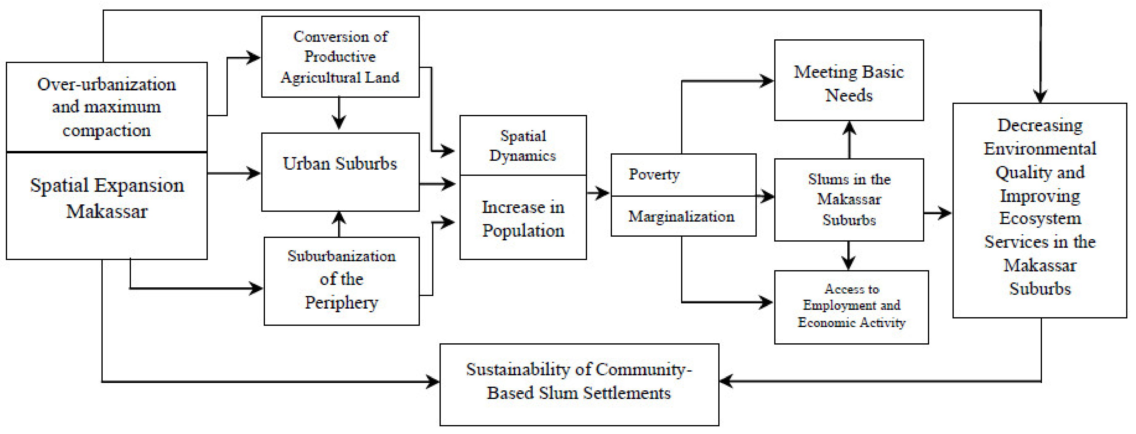
2. Conceptual Framework for Slum Settlement in Makassar
2.1. Urbanization, Poverty, and Community Marginality
2.2. Slum Settlement Handling Sustainability
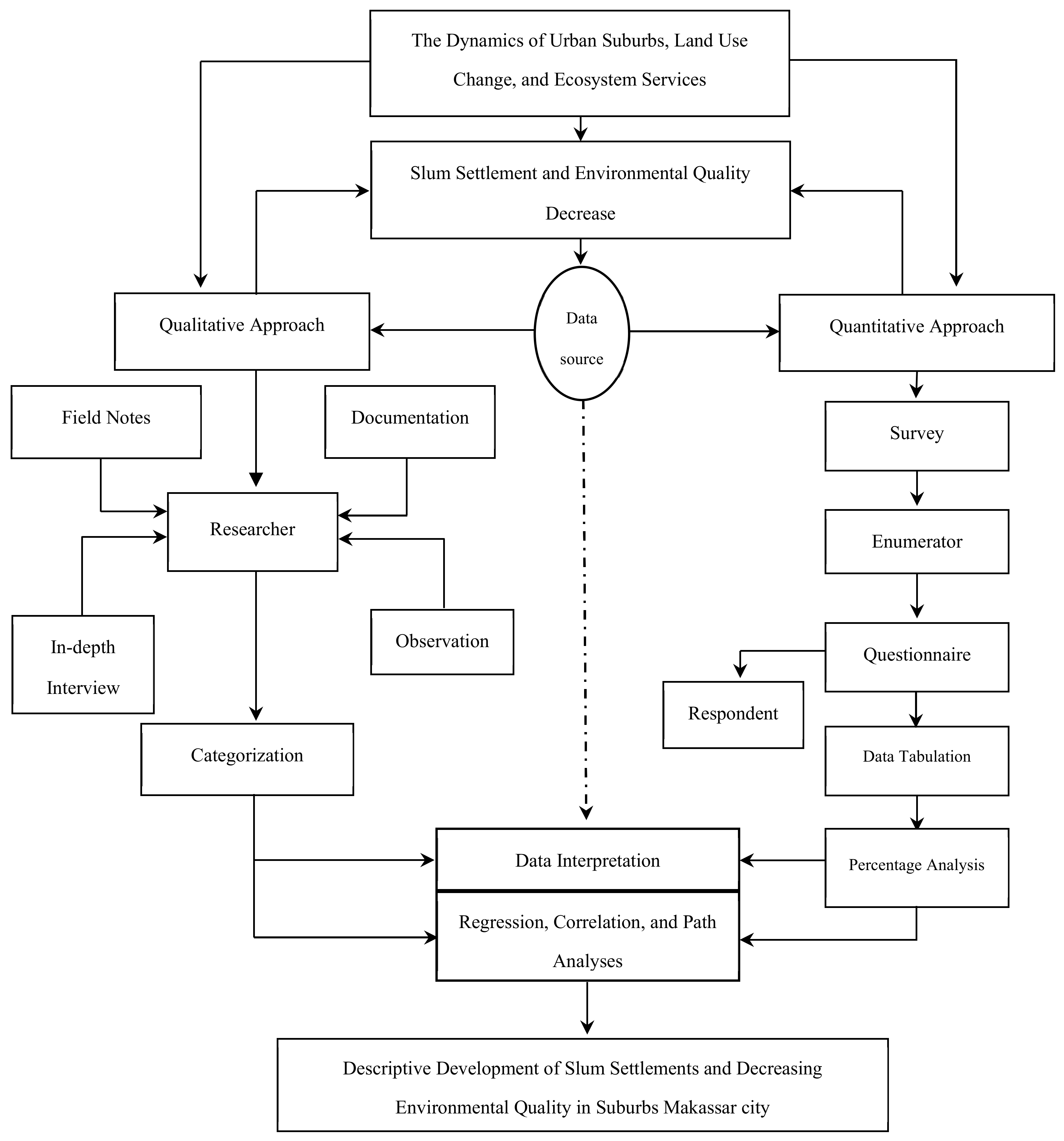
3. Materials and Methods
3.1. Research Stages
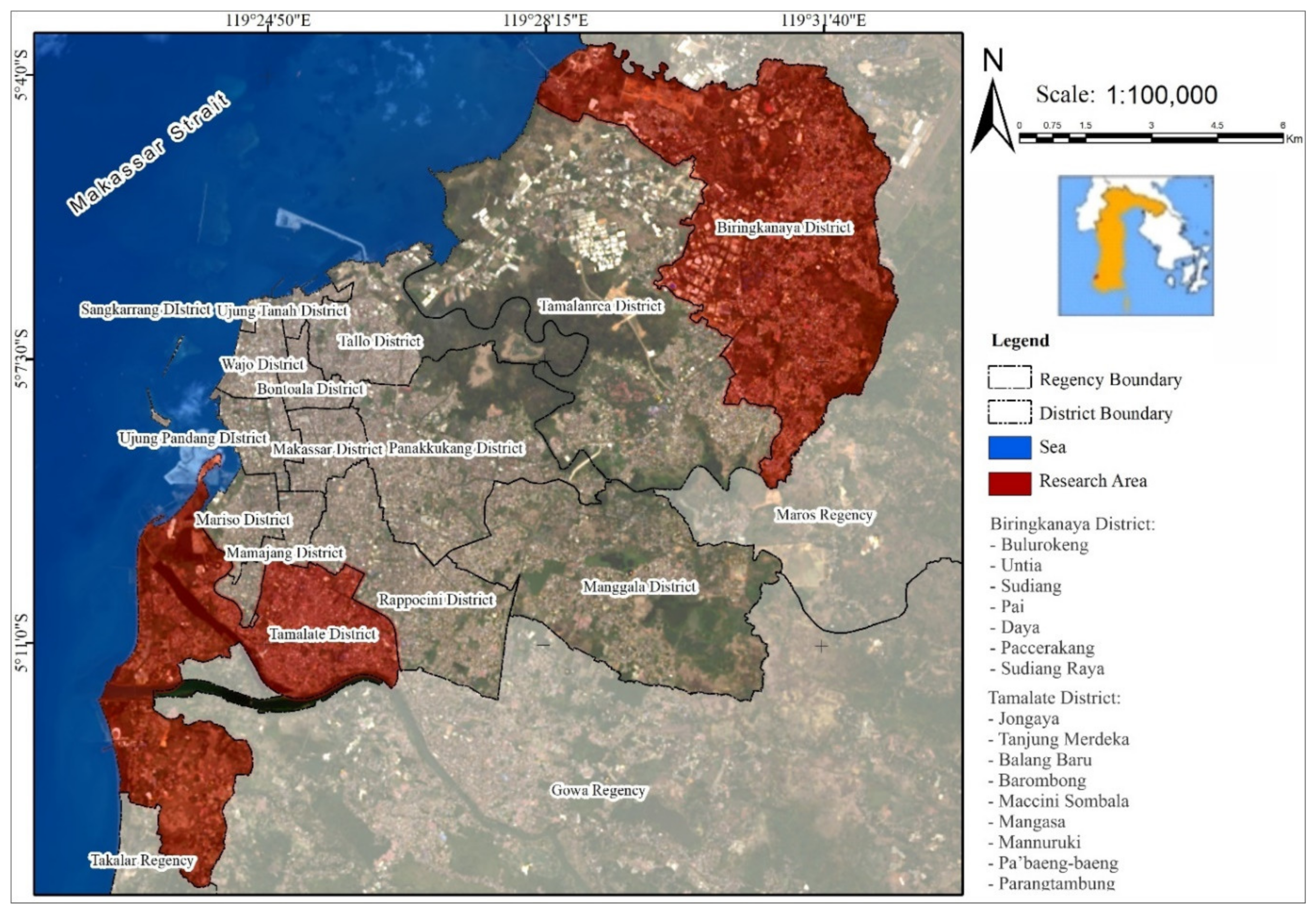
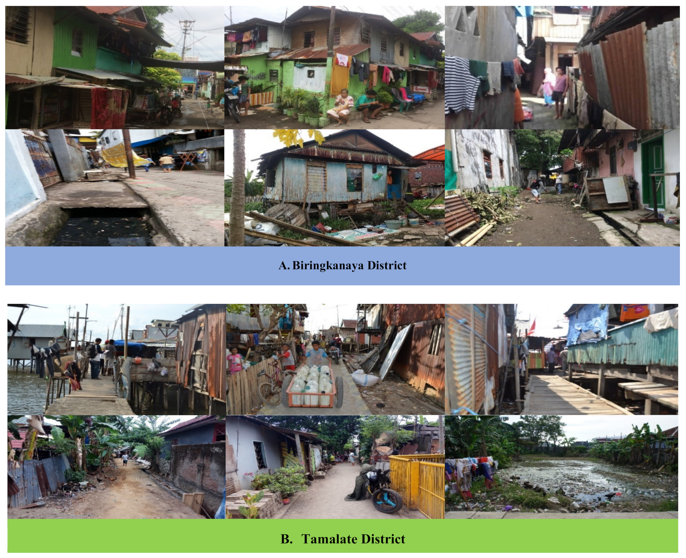
3.2. Study Area
3.3. Data Collection
3.4. Population and Research Samples
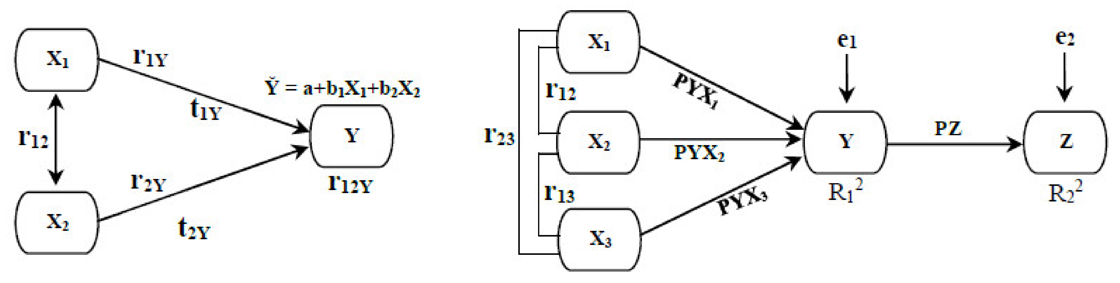
3.5. Data Analysis
3.5.1. Domain Analysis
3.5.2. Taxonomic Analysis
3.5.3. Componential Analysis
4. Result
4.1. Determinants of Spatial Dynamics in Suburbs and Slum Settlements
4.2. Effect of Spatial Expansion on Slum Settlements
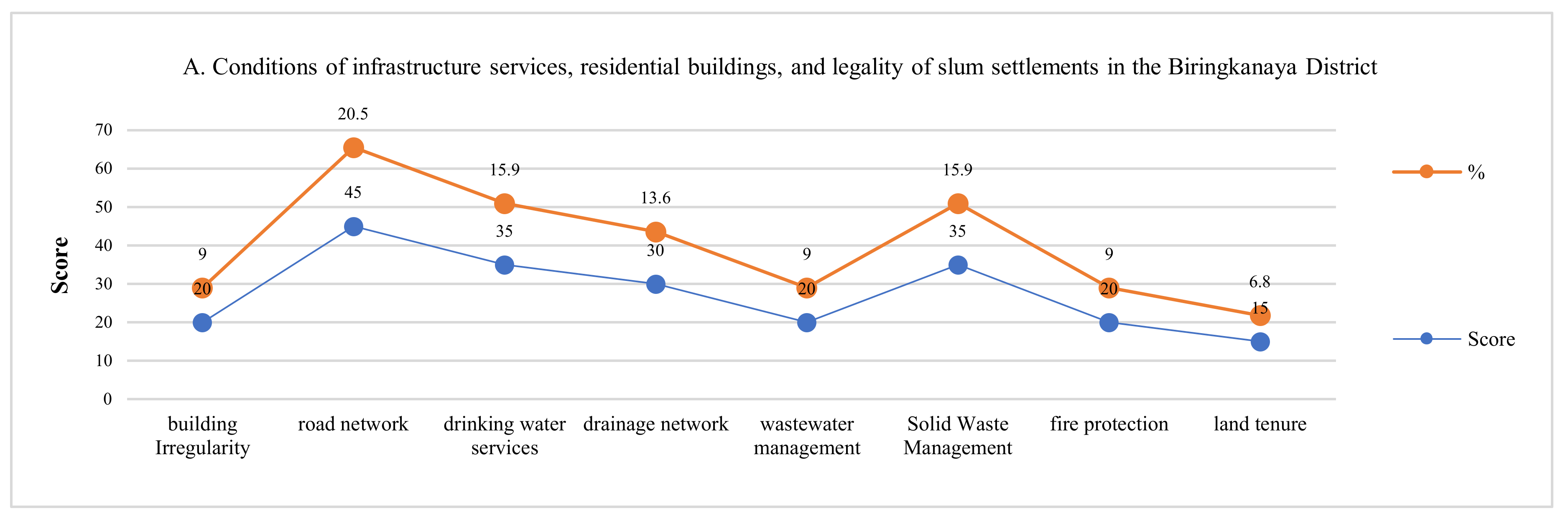
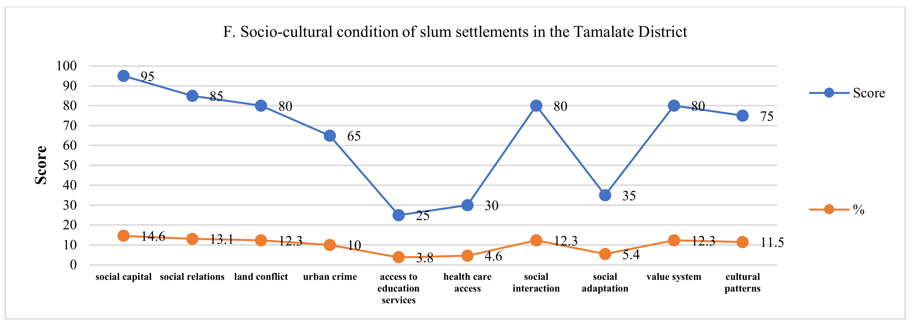
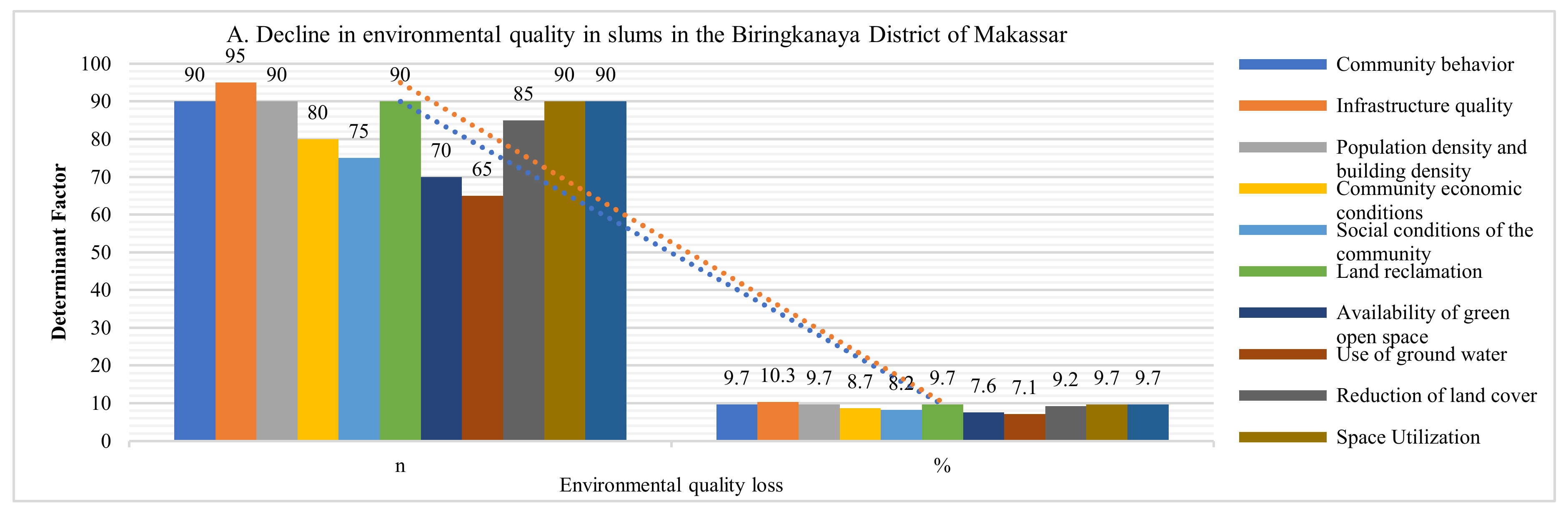
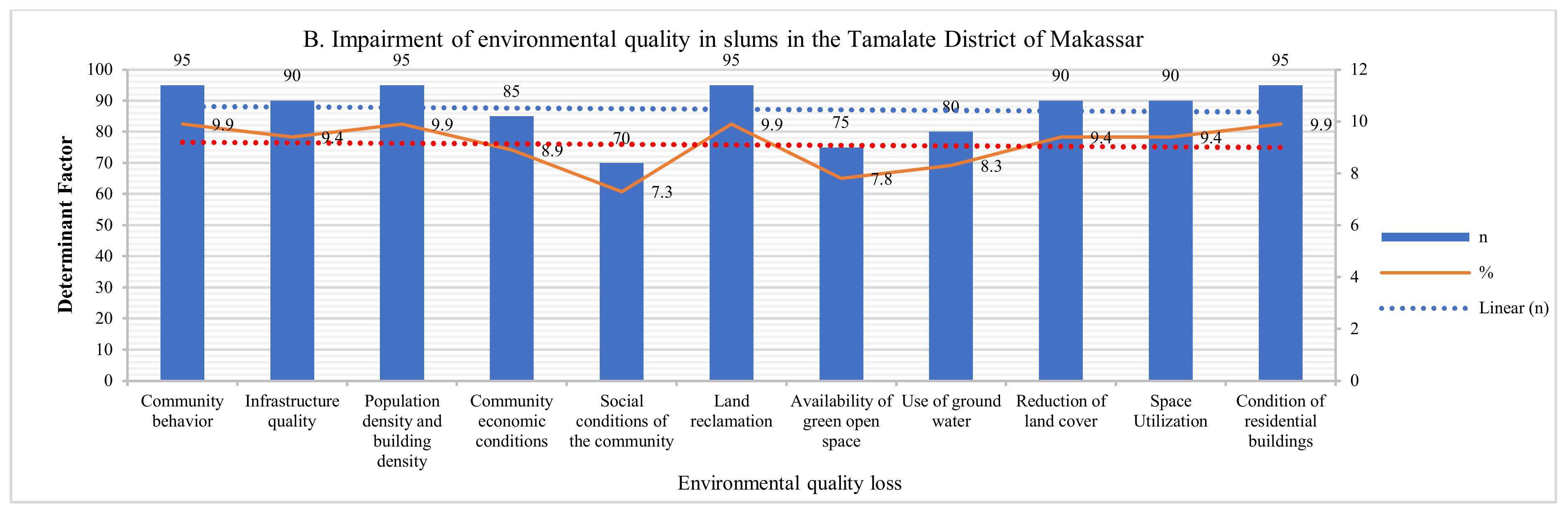
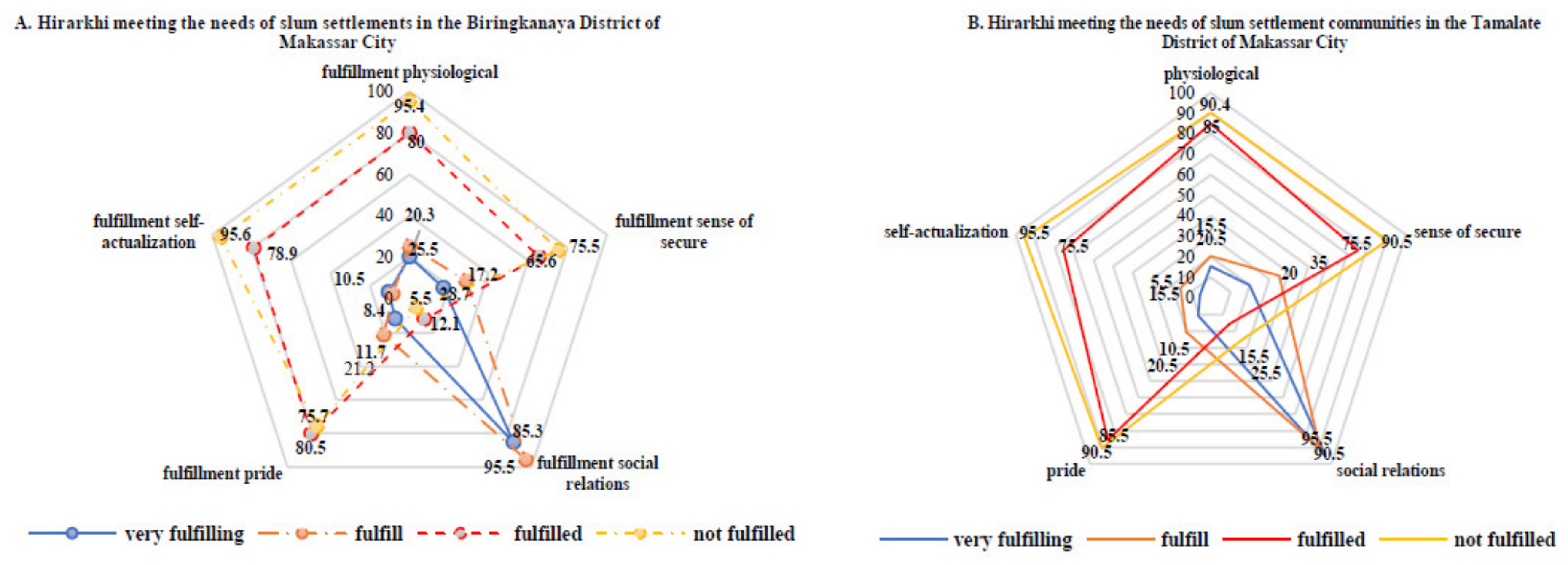
4.3. Impairment of Environmental Quality and Hierarchy of Meeting Community Needs
5. Discussion
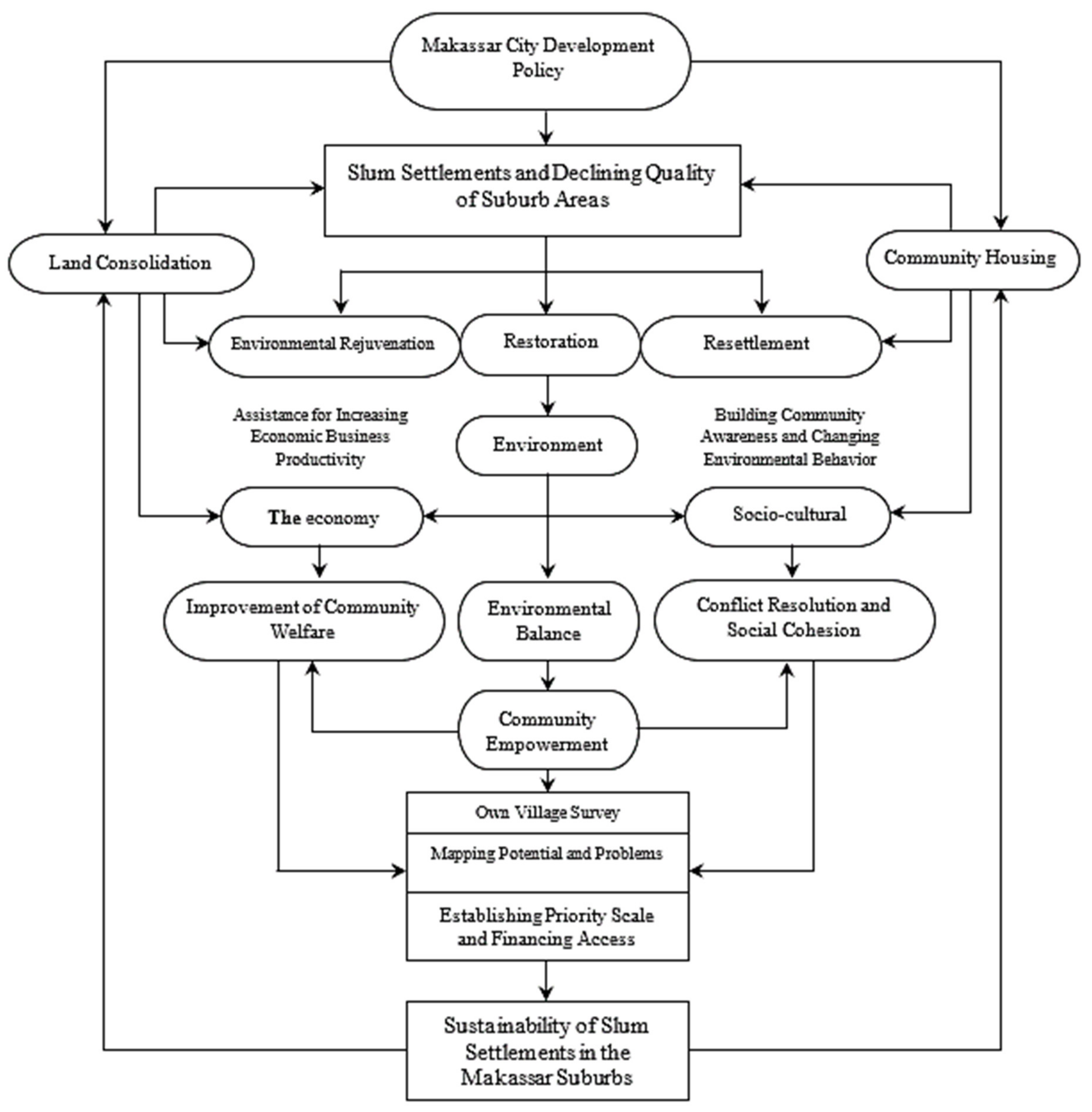
5.1. Solutions for Slum Settlement in Makassar Suburbs
5.2. Management and Control of Environmental Pollution in Slums
5.3. Sustainability of Community-Based Slum Settlements
6. Conclusions
Author Contributions
Funding
Acknowledgments
Conflicts of Interest
References
- Jones, B.; Balk, D.; Leyk, S. Urban Change in the United States, 1990–2010: A Spatial Assessment of Administrative Reclassification. Sustainability 2020, 12, 1649. [Google Scholar] [CrossRef] [Green Version]
- Surya, B. Globalization, Modernization, Mastery of Reproduction of Space, Spatial Articulation and Social Change in Developmental Dynamics in Suburb Area of Makassar City (A Study Concerning on Urban Spatial Sociology). Asian Soc. Sci. 2014, 10, 261–268. [Google Scholar] [CrossRef] [Green Version]
- He, M.; Zeng, L.; Wu, X.; Luo, J. The Spatial and Temporal Evolution of Logistics Enterprises in the Yangtze River Delta. Sustainability 2019, 11, 5318. [Google Scholar] [CrossRef] [Green Version]
- Zhao, X.; Li, S.; Pu, J.; Miao, P.; Wang, Q.; Tan, K. Optimization of the National Land Space Based on the Coordination of Urban-Agricultural-Ecological Functions in the Karst Areas of Southwest China. Sustainability 2019, 11, 6752. [Google Scholar] [CrossRef] [Green Version]
- Surya, B. Spatial Interaction Pattern and the Process of City Activity Formation System (Case study, Ternate City, Tidore Archipelago City and Sofifi City of North Maluku, Indonesia). Res. J. Appl. Sci. 2015, 10, 880–892. [Google Scholar]
- Surya, B. The Processes Analysis of Urbanization, Spatial Articulation, Social Change and Social Capital Difference in the Dynamics of New Town Development in the Fringe Area of Makassar City (Case Study: In Metro Tanjung Bunga Area, Makassar City). Procedia Soc. Behav. Sci. 2016, 227, 216–231. [Google Scholar] [CrossRef] [Green Version]
- Mukherjee, S.; Bebermeier, W.; Schütt, B. An Overview of the Impacts of Land Use Land Cover Changes (1980–2014) on Urban Water Security of Kolkata. Land 2018, 7, 91. [Google Scholar] [CrossRef] [Green Version]
- Niva, V.; Taka, M.; Varis, O. Rural-Urban Migration and the Growth of Informal Settlements: A Socio-Ecological System Conceptualization with Insights Through a “Water Lens”. Sustainability 2019, 11, 3487. [Google Scholar] [CrossRef] [Green Version]
- Al Jarah, S.H.; Zhou, B.; Abdullah, R.J.; Lu, Y.; Yu, W. Urbanization and Urban Sprawl Issues in City Structure: A Case of the Sulaymaniah Iraqi Kurdistan Region. Sustainability 2019, 11, 485. [Google Scholar] [CrossRef] [Green Version]
- Puerari, E.; de Koning, J.I.J.C.; von Wirth, T.; Karré, P.M.; Mulder, I.J.; Loorbach, D.A. Co-Creation Dynamics in Urban Living Labs. Sustainability 2018, 10, 1893. [Google Scholar] [CrossRef] [Green Version]
- Bourne, L.S. (Ed.) Book Review: Internal Structure of The City, New York; Oxford University Press: Oxford, UK, 1971. [Google Scholar] [CrossRef]
- Perroux, F. Note sur la notion de poles croissance. Econ. Appl. 1955, 1–2, 307–320. Available online: https://www.scienceopen.com/document?vid=72262ded-0cf8-4499-9edf-d47f35b29090 (accessed on 3 March 2020).
- Friedmann, J. Empowerment the Political of Alternative Development; Blackwell Publishers, Three Cambridge Center: Cambridge, MA, USA, 1992; Available online: https://0-www-wiley-com.brum.beds.ac.uk/en-us/Empowerment%3A+The+Politics+of+Alternative+Development-p-9781557863003 (accessed on 6 March 2020).
- Morrison, E.W. Role Definitions and Organizational Citizenship Behavior: The Importance of The Employee’s Perspective. Acad. Manag. J. 2017, 37, 1543–1567. [Google Scholar]
- Surya, B. Social Change, Spatial Articulation in the Dynamics of Boomtown Construction and Development (Case Satudy of Metro Tanjung Bunga Boomtown, Makassar). Mod. Appl. Sci. 2014, 8, 238–245. [Google Scholar] [CrossRef] [Green Version]
- Yang, Z.; Lei, J.; Gang, L.J. Identifying the Determinants of Urbanization in Prefecture-Level Cities in China: A Quantitative Analysis Based on Spatial Production Theory. Sustainability 2019, 11, 1204. [Google Scholar] [CrossRef] [Green Version]
- Farrell, K. The Rapid Urban Growth Triad: A New Conceptual Framework for Examining the Urban Transition in Developing Countries. Sustainability 2017, 9, 1407. [Google Scholar] [CrossRef] [Green Version]
- Bappenas. Rencana Pembangunan Jangka Menengah Nasional 2020–2024. 2019. Available online: https://www.bappenas.go.id/files/rpjmn/Narasi%20RPJMN%20IV%202020-2024_Revisi%2028%20Juni%202019.pdf (accessed on 3 March 2020).
- Roberts, M.; Gil Sander, F.; Tiwari, S. Realizing Indonesia’s Urban Potential 2045; World Bank Group: Washington, DC, USA, 2019; Available online: https://openknowledge.worldbank.org/handle/10986/31304 (accessed on 3 March 2020).
- Saleh, H.; Surya, B.; Hamsina, H. Implementation of Sustainable Development Goals to Makassar Zero Waste and Energy Source. Int. J. Energy Econ. Policy 2020, 10, 530–538. [Google Scholar] [CrossRef]
- Neiderud, C.J. How urbanization affects the epidemiology of emerging infectious diseases. Infect. Ecol. Epidemiol. 2015, 5, 1–9. [Google Scholar] [CrossRef]
- White, M.J.; Muhidin, S.; Andrzejewski, C.; Tagoe, E.; Knight, R.; Reed, H. Urbanization and fertility: An event-history analysis of Coastal Ghana. Demography 2008, 45, 803–816. [Google Scholar] [CrossRef]
- Surya, B.; Ahmad, D.N.A.; Sakti, H.H.; Sahban, H. Land Use Change, Spatial Interaction, and Sustainable Development in the Metropolitan Urban Areas, South Sulawesi Province, Indonesia. Land 2020, 9, 95. [Google Scholar] [CrossRef] [Green Version]
- Olajide, O.A.; Agunbiade, M.E.; Bishi, H.B. The realities of Lagos urban development vision on livelihoods of the urban poor. J. Urban Manag. 2018, 7, 21–31. [Google Scholar] [CrossRef]
- Surya, B.; Saleh, H.; Syafri, S.; Ahmad, D.N.A. Impact and Sustainability of New Urban Area Development in Moncongloe-Pattalassang, Mamminasata Metropolitan. J. Southwest Jiaotong Univ. 2019, 54. [Google Scholar] [CrossRef]
- Sharifi, A. Resilient urban forms: A macro-scale analysis. Cities 2019, 85, 1–14. [Google Scholar] [CrossRef]
- Jones, P. Formalizing the Informal: Understanding the Position of Informal Settlements and Slums in Sustainable Urbanization Policies and Strategies in Bandung, Indonesia. Sustainability 2017, 9, 1436. [Google Scholar] [CrossRef] [Green Version]
- Pedro, A.A.; Queiroz, A.P. Slum: Comparing municipal and census basemaps. Habitat Int. 2019, 83, 30–40. [Google Scholar] [CrossRef]
- Friesen, J.; Taubenböck, H.; Wurm, M.; Pelz, P.F. The similar size of slums. Habitat Int. 2018, 73, 79–88. [Google Scholar] [CrossRef]
- Surya, B.; Ruslan, M.; Abubakar, H. Inequility of Space Reproduction Control and Urban Slum Area Management Sustainability (Case Study: Slum Area of Buloa Urban Village in Makassar City). J. Eng. Appl. Sci. 2018, 13, 6033–6042. [Google Scholar]
- Li, F.; Zheng, W.; Wang, Y.; Liang, J.; Xie, S.; Guo, S.; Li, X.; Yu, C. Urban Green Space Fragmentation and Urbanization: A Spatiotemporal Perspective. Forests 2019, 10, 333. [Google Scholar] [CrossRef] [Green Version]
- Hussain, T.; Abbas, J.; Wei, Z.; Nurunnabi, M. The Effect of Sustainable Urban Planning and Slum Disamenity on the Value of Neighboring Residential Property: Application of the Hedonic Pricing Model in Rent Price Appraisal. Sustainability 2019, 11, 1144. [Google Scholar] [CrossRef] [Green Version]
- Teferi, Z.A.; Newman, P. Slum Regeneration and Sustainability: Applying the Extended Metabolism Model and the SDGs. Sustainability 2017, 9, 2273. [Google Scholar] [CrossRef] [Green Version]
- Surya, B. The Dynamics of Spatial Structure and Spatial Pattern Changes at the Fringe Area of Makassar City. Indones. J. Geogr. 2015, 47, 11–19. [Google Scholar] [CrossRef]
- Takeuchi, A.; Cropper, M.; Bento, A. Measuring the welfare effects of slum improvement programs: The case of Mumbai. J. Urban Econ. 2008, 64, 65–84. [Google Scholar] [CrossRef] [Green Version]
- Giyarsih, S.R. Gejala Urban Sprawl Sebagai Pemicu Proses Densifikasi Permukiman di Daerah Pinggiran Kota (Urban Fringe Area). J. Perenc. Wil. Kota 2001, 12. Available online: http://journals.itb.ac.id/index.php/jpwk/article/view/4312 (accessed on 5 January 2020).
- Meredith, T.; MacDonald, M. Community-supported slum-upgrading: Innovations from Kibera, Nairobi, Kenya. Habitat Int. 2017, 60, 1–9. [Google Scholar] [CrossRef]
- Maheshwari, B. (Ed.) Balanced Urban Development: Is It a Myth or Reality? Springer Open: New York, NY, USA, 2016; Available online: https://0-link-springer-com.brum.beds.ac.uk/chapter/10.1007/978-3-319-28112-41 (accessed on 2 January 2020).
- Yanbo, Q.; Guanghui, J.; Yuting, Y.; Qiuyue, Z.; Yuling, L.; Wenqiu, M. Multi-scale analysis on spatial morphology differentiation and formation mechanism of rural residential land: A case study in Shandong Province, China. Habitat Int. 2018, 71, 135–146. [Google Scholar] [CrossRef]
- Chang, H.S.; Chiu, S.L. Discussion on sustainable land use allocation toward the sustainable city A practice on Linco New Town. Procedia Environ. Sci. 2013, 17, 408–417. [Google Scholar] [CrossRef] [Green Version]
- Grădinaru, S.R.; Iojă, C.I.; Stupariu, I.P. Do Post-Socialist Urban Areas Maintain their Sustainable Compact Form? Romanian Urban Areas as Case Study. J. Urban. Reg. Anal. 2015, 7, 129–144. Available online: http://www.jurareview.ro/chapters/get_chapter/78 (accessed on 3 March 2020).
- Grimm, N.B.; Faeth, S.H.; Golubiewski, N.E.; Redman, C.L.; Wu, J.; Bai, X.; Briggs, J.M. Global change and the ecology of cities. Science 2008, 319, 756–760. [Google Scholar] [CrossRef] [Green Version]
- Wang, Y.; Huang, C.; Feng, Y.; Zhao, M.; Gu, J. Using Earth Observation for Monitoring SDG 11.3.1- Ratio of Land Consumption Rate to Population Growth Rate in Mainland China. Remote Sens. 2020, 12, 357. [Google Scholar] [CrossRef] [Green Version]
- Surya, B. Change Phenomena of Spatial Physical in the Dynamics of Development in Urban Fringe Area. Indones. J. Geogr. 2016, 48, 118–134. [Google Scholar] [CrossRef] [Green Version]
- Rao, F. Resilient Forms of Shopping Centers Amid the Rise of Online Retailing: Towards the Urban Experience. Sustainability 2019, 11, 3999. [Google Scholar] [CrossRef] [Green Version]
- Wei, C.; Padgham, M.; Barona, P.C.; Blaschke, T. Scale-Free Relationships between Social and Landscape Factors in Urban Systems. Sustainability 2017, 9, 84. [Google Scholar] [CrossRef] [Green Version]
- McCarthy, K. Urbanization: An Introduction to Urban Geography, 3rd ed.; Pearson Education (US): New York, NY, USA, 2012; Available online: https://www.ancient.eu/books/0321736435/ (accessed on 8 March 2020).
- Surya, B.; Saleh, H.; Ariyanto. Transformation of metropolitan suburban area (a study on new town development in Moncongloe-Pattalassang Metropolitan Maminasata). IOP Conf. Ser. Earth Environ. Sci. 2018, 202, 012027. [Google Scholar] [CrossRef] [Green Version]
- Terfa, B.K.; Chen, N.; Zhang, X.; Niyogi, D. Urbanization in Small Cities and Their Significant Implications on Landscape Structures: The Case in Ethiopia. Sustainability 2020, 12, 1235. [Google Scholar] [CrossRef] [Green Version]
- Piekut, M. Living Standards in One-Person Households of the Elderly Population. Sustainability 2020, 12, 992. [Google Scholar] [CrossRef] [Green Version]
- Cao, X.; Zhou, B.; Shi, Y.; Pei, X. The Unbalanced Analysis of Economic Urbanization—A Case Study of Typical Cities in China. ISPRS Int. J. Geo Inf. 2019, 9, 13. [Google Scholar] [CrossRef] [Green Version]
- Florida, R.; Mellander, C. The Geography of Economic Segregation. Soc. Sci. 2018, 7, 123. [Google Scholar] [CrossRef] [Green Version]
- Villaça, F. São Paulo: Urban segregation and inequality. Estud. Avançados 2011, 25, 37–58. [Google Scholar] [CrossRef] [Green Version]
- Nam, S.-J. Multidimensional Poverty among Female Householders in Korea: Application of a Latent Class Model. Sustainability 2020, 12, 701. [Google Scholar] [CrossRef] [Green Version]
- Rój, J. Inequality in the Distribution of Healthcare Human Resources in Poland. Sustainability 2020, 12, 2043. [Google Scholar] [CrossRef] [Green Version]
- Surya, B.; Saleh, H.; Remmang, H. Economic Gentrification and Socio-Cultural Transformation Metropolitan Suburban of Mamminasata. J. Eng. Appl. Sci. 2018, 13, 6072–6084. [Google Scholar]
- Abrams, C. Man’s Struggle for Shelter in An Urbanizing World; MIT Press: Cambridge, UK, 1964; Available online: https://mitpress.mit.edu/books/mans-struggle-shelter-urbanizing-world (accessed on 1 March 2020).
- Maslow, A.H. Theory Z. In The Farther Reaches of Human Nature; Arkana: New York, NY, USA, 1971; Available online: https://www.audible.com/pd/The-Farther-Reaches-of-Human-Nature-Audiobook/1684570778?ds_rl=1262685&ds_rl=1263561&ds_rl=1260658&mkwid=DSAINTTitle_dc&pcrid=239333741509&pmt=b&pkw=&source_code=GO1GBSH07271690CB&cvosrc=ppc%20dynamic%20search.google.634950925&cvo_crid=239333741509&cvo_pid=33581432409&gclid=Cj0KCQjw0rr4BRCtARIsAB0_48Pj2VWh1WOSfNUt2XHfYJ-Zg_lbo6kmFvWjUTZEur7QklWte20ODt0aAmB4EALw_wcB&gclsrc=aw.ds (accessed on 8 March 2020).
- Surya, B. Spatial Articulation and Co-Existence of Mode of Production in the Dynamics of Development at the Urban Fringe of Makassar City. J. Eng. Appl. Sci. 2015, 10, 214–222. [Google Scholar]
- Yin, R.K. Case Study Research Design dan Method; Sage Publication Inc.: Thousand Oaks, CA, USA, 2009; Available online: https://books.google.co.id/books?id=FzawIAdilHkC&printsec=frontcover&hl=id&source=gbs_ge_summary_r&cad=0#v=onepage&q&f=false (accessed on 5 February 2020).
- Sugiono. Metode Penelitian dan Pengembangan. In Untuk Bidang: Pendidikan, Manajemen, Sosial dan Teknik; Alfabeta: Bandung, Indonesia, 2016. [Google Scholar]
- Creswell, J.W. Research Design Qualitative, Quantitative and Mixed Methods Approach, 4th ed.; Pustaka Pelajar: Yogyakarta, Indonesia, 2016; Available online: http://pustakapelajar.co.id/buku/research-design-pendekatan-metode-kualitatif-kuantitatif-dan-campuran-ed-4/ (accessed on 8 March 2020).
- Denzin, N.K.; Lincoln, Y.S. HandBook of Qualitative Research; Pustaka Pelajar: Yogyakarta, Indonesia, 2009; Available online: https://openlibrary.telkomuniversity.ac.id/pustaka/9769/handbook-of-qualitative-research.html (accessed on 8 March 2020).
- BPS. Kota Makassar. Kota Makassar Dalam Angka. 2019. Available online: https://makassarkota.bps.go.id/publication/2020/02/28/1eb7810a4bc81adce1186465/kota-makassar-dalam-angka-2020--penyediaan-data-untuk-perencanaan-pembangunan.html (accessed on 3 February 2020).
- Cochran, W.G. Teknik Penarikan Sampel, 3rd ed.; Universitas Indonesia: Depok, Indonesia, 1991; Available online: https://www.tokopedia.com/jamrist/teknik-penarikan-sampel-edisi-3-ketiga-william-g-cochran (accessed on 8 March 2020).
- Faisal, S. Format-Format Penelitian Sosial; Raja Grafindo Persada PT: Depok, Indonesia, 2005; Available online: http://library.um.ac.id/free-contents/index.php/buku/detail/format-format-penelitian-sosial-sanapiah-faisal-29169.html (accessed on 8 March 2020).
- Zhen, N.; Fu, B.; Lu, Y.; Wang, S. Poverty reduction, environmental protection, and ecosystem services: A prospective theory for sustainable development. Chin. Geogr. Sci. 2014, 24, 83–92. [Google Scholar] [CrossRef]
- Burns, P.A.; Snow, R.C. The built environment and the impact of neighborhood characteristics on youth sexual risk behavior in Cape Town, South Africa. Health Place 2012, 18, 1088–1100. [Google Scholar] [CrossRef] [Green Version]
- Chimankar, D.A. Urbanization and Condition of Urban Slums in India. Indones. J. Geogr. 2016, 48, 28–36. [Google Scholar] [CrossRef]
- Nzau, B.; Trillo, C. Affordable Housing Provision in Informal Settlements through Land Value Capture and Inclusionary Housing. Sustainability 2020, 12, 5975. [Google Scholar] [CrossRef]
- Meyer, N.; Auriacombe, C. Good Urban Governance and City Resilience: An Afrocentric Approach to Sustainable Development. Sustainability 2019, 11, 5514. [Google Scholar] [CrossRef] [Green Version]
- Surya, B.; Saleh, H.; Abubakar, H. Sustainability of Slum-Based Settlement Management Community Socio-Economic Empowerment (Study on Slum Settlements in Panakkukang District, Makassar City). J. Eng. Appl. Sci. 2020, 15, 141–152. [Google Scholar] [CrossRef] [Green Version]
- Williams, D.S.; Costa, M.M.; Celliers, L.; Sutherland, C. Informal Settlements and Flooding: Identifying Strengths and Weaknesses in Local Governance for Water Management. Water 2018, 10, 871. [Google Scholar] [CrossRef] [Green Version]
- Sultana, S.; Satyanarayana, A.N.V. Assessment of urbanisation and urban heat island intensities using landsat imageries during 2000–2018 over a sub-tropical Indian City. Sustain. Cities Soc. 2020, 52, 101846. [Google Scholar] [CrossRef]
- Kuffer, M.; Pfeffer, K.; Sliuzas, R. Slums from Space—15 Years of Slum Mapping Using Remote Sensing. Remote Sens. 2016, 8, 455. [Google Scholar] [CrossRef] [Green Version]
- Kshetrimayum, B.; Bardhan, R.; Kubota, T. Factors Affecting Residential Satisfaction in Slum Rehabilitation Housing in Mumbai. Sustainability 2020, 12, 2344. [Google Scholar] [CrossRef] [Green Version]
- Hlaváček, P.; Kopáček, M.; Horáčková, L. Impact of Suburbanisation on Sustainable Development of Settlements in Suburban Spaces: Smart and New Solutions. Sustainability 2019, 11, 7182. [Google Scholar] [CrossRef] [Green Version]
- Corburn, J.; Sverdlik, A. Slum Upgrading and Health Equity. Int. J. Environ. Res. Public Health 2017, 14, 342. [Google Scholar] [CrossRef] [PubMed] [Green Version]
- Average, C. Low income housing problems and low-income housing solutions: Opportunities and challenges in Bulawayo. J. Hous. Built Environ. 2019, 34, 927–938. [Google Scholar] [CrossRef] [Green Version]
- Richmond, A.; Myers, I.; Namuli, H. Urban Informality and Vulnerability: A Case Study in Kampala, Uganda. Urban Sci. 2018, 2, 22. [Google Scholar] [CrossRef] [Green Version]
- Krishna, A. Active Social Capital; Columbia University Press: New York, NY, USA, 2002; Available online: http://cup.columbia.edu/book/active-social-capital/9780231125703 (accessed on 5 February 2020).
- Martin, K.S.; Rogers, B.L.; Cook, J.T.; Joseph, H.M. Social capital is associated with decreased risk of hunger. Soc. Sci. Med. 2004, 58, 2645–2654. [Google Scholar] [CrossRef]
- Cepeliauskaite, G.; Stasiskiene, Z. The Framework of the Principles of Sustainable Urban Ecosystems Development and Functioning. Sustainability 2020, 12, 720. [Google Scholar] [CrossRef] [Green Version]
- Seto, K.C.; Woodcock, C.E.; Song, C.; Huang, X.; Lu, J.; Kaufmann, R.K. Monitoring land-use change in the pearl river delta using landsat TM. Int. J. Remote Sens. 2002, 23, 1985–2004. [Google Scholar] [CrossRef]
- Naeem, S.; Cao, C.; Fatima, K.; Najmuddin, O.; Acharya, B.K. Landscape Greening Policies-based Land Use/Land Cover Simulation for Beijing and Islamabad—An Implication of Sustainable Urban Ecosystems. Sustainability 2018, 10, 1049. [Google Scholar] [CrossRef] [Green Version]
- Ding, Y.; Peng, J. Impacts of Urbanization of Mountainous Areas on Resources and Environment: Based on Ecological Footprint Model. Sustainability 2018, 10, 765. [Google Scholar] [CrossRef] [Green Version]
- Surya, B.; Syafri, S.; Sahban, H.; Sakti, H.H. Natural Resource Conservation Based on Community Economic Empowerment: Perspectives on Watershed Management and Slum Settlements in Makassar City, South Sulawesi, Indonesia. Land 2020, 9, 95. [Google Scholar] [CrossRef] [Green Version]
- Ruzek, W. The Informal Economy as a Catalyst for Sustainability. Sustainability 2015, 7, 23–34. [Google Scholar] [CrossRef] [Green Version]
- Kamalipour, H.; Peimani, N. Negotiating Space and Visibility: Forms of Informality in Public Space. Sustainability 2019, 11, 4807. [Google Scholar] [CrossRef] [Green Version]
- Han, H.; Nguyen, T.V.T.; Sahito, N. Sidewalk Zoom-In: A Spatial–Temporal Negotiation and Self-Organization within a Sociable Space. Sustainability 2019, 11, 6241. [Google Scholar] [CrossRef] [Green Version]
- Uddin, N. Assessing Urban Sustainability of Slum Settlements in Bangladesh: Evidence from Chittagong City. J. Urban Manag. 2018, 7, 32–42. [Google Scholar] [CrossRef]
- Hermoso, M.; Ruiz, M.J.G.; Osorio, F. Efficiency of Flood Control Measures in a Sewer System Located in the Mediterranean Basin. Water 2018, 10, 1437. [Google Scholar] [CrossRef] [Green Version]
- Nengoue, U.A.N.; Rey, P.L.I.; Solano, F.J.M.; Meliá, D.M.; Valderrama, J.G.S. Urban Drainage Network Rehabilitation Considering Storm Tank Installation and Pipe Substitution. Water 2019, 11, 515. [Google Scholar] [CrossRef] [Green Version]
- Lin, L.; Jia, H.; Pan, Y.; Qiu, L.; Gan, M.; Lu, S.; Deng, J.; Yu, Z.; Wang, K. Exploring the Patterns and Mechanisms of Reclaimed Arable Land Utilization under the Requisition Compensation Balance Policy in Wenzhou, China. Sustainability 2018, 10, 75. [Google Scholar] [CrossRef] [Green Version]
- Irda Sari, S.Y.; Sunjaya, D.K.; Furusawa, H.S.; Watanabe, C.; Raksanagara, A.S. Water Sources Quality in Urban Slum Settlement along the Contaminated River Basin in Indonesia: Application of Quantitative Microbial Risk Assessment. J. Environ. Public Health 2018, 2018, 3806537. [Google Scholar] [CrossRef] [Green Version]
- Hasan, A.; Zaman, M.O.; Munmum, U.H.; Quadir, D.A.; Rahman, M.H. Environmental Impact on Safe Drinking Water and Livelihood in Urban Slum of Barisal Metropolitan City of Bangladesh. J. Humanit. Soc. Sci. 2018, 23, 40–47. [Google Scholar]
- Littig, B.; Griessler, E. Social sustainability: A catchword between political pragmatism and social theory. Int. J. Sustain. Dev. 2005, 8, 65–79. [Google Scholar] [CrossRef] [Green Version]
- Boström, M.A. Missing pillar? Challenges in theorizing and practicing social sustainability: Introductory article in the special issue. J. Sustain. Sci. Pract. Policy 2012, 8, 3–14. [Google Scholar] [CrossRef] [Green Version]
- Su, W.; Ye, G.; Yao, S.; Yang, G. Urban Land Pattern Impacts on Floods in a New District of China. Sustainability 2014, 6, 6488–6508. [Google Scholar] [CrossRef] [Green Version]
- Liu, Z.; Cai, Y.; Wang, S.; Lan, F.; Wu, X. Small and Medium-Scale River Flood Controls in Highly Urbanized Areas: A Whole Region Perspective. Water 2020, 12, 182. [Google Scholar] [CrossRef] [Green Version]
- Dushkova, D.; Haase, D. Not Simply Green: Nature-Based Solutions as a Concept and Practical Approach for Sustainability Studies and Planning Agendas in Cities. Land 2020, 9, 19. [Google Scholar] [CrossRef] [Green Version]
- Somanje, A.N.; Mohan, G.; Lopes, J.; Mensah, A.; Gordon, C.; Zhou, X.; Moinuddin, M.; Saito, O.; Takeuchi, K. Challenges and Potential Solutions for Sustainable Urban-Rural Linkages in a Ghanaian Context. Sustainability 2020, 12, 507. [Google Scholar] [CrossRef] [Green Version]
- Sharmeen, N.; Houston, D. Spatial Characteristics and Activity Space Pattern Analysis of Dhaka City, Bangladesh. Urban Sci. 2019, 3, 36. [Google Scholar] [CrossRef] [Green Version]
- Lee, S.; Jung, M. Social Capital, Community Capacity, and Health. Health Care Manag. 2018, 37, 290–298. [Google Scholar] [CrossRef]
- Gulyani, S.; Talukdar, D.; Jack, D. Proverty, Living Conditions and Infrastructure Acces: A Comparison of Slum in Dakar, Johannesburg, and Nairobi; The World Bank Afrika Region, Sustainable Development Devision: Washington, DC, USA, 2010; pp. 1–53. Available online: https://www.researchgate.net/publication/46443956_Poverty_living_conditions_and_infrastructure_access_a_comparison_of_slums_in_Dakar_Johannesburg_and_Nairobi (accessed on 5 February 2020).
- Surya, B. Optimization of Function and Role of Traditional Markets in Urban Development System of Ketapang City: A case study: Range Sentap Market, Delta Pawan Subdistrict, Ketapang city. World Appl. Sci. J. 2015, 33, 1457–1471. [Google Scholar]
- Pollán, M.M.; Pazos, M.A.; Rodríguez, C.P.; Lozano, F.B. The Inefficiency of the Neoclassical Paradigm in the Promotion of Subjective Well-Being and Socioeconomic, and Environmental Sustainability: An Empirical Test for the Spanish Case. Sustainability 2019, 11, 7102. [Google Scholar] [CrossRef] [Green Version]
- Purwanto, E.; Sugiri, A.; Novian, R. Determined Slum Upgrading: A Challenge to Participatory Planning in Nanga Bulik, Central Kalimantan, Indonesia. Sustainability 2017, 9, 1261. [Google Scholar] [CrossRef] [Green Version]
- Asiama, K.; Bennett, R.; Zevenbergen, J. Participatory Land Administration on Customary Lands: A Practical VGI Experiment in Nanton, Ghana. ISPRS Int. J. Geo Inf. 2017, 6, 186. [Google Scholar] [CrossRef] [Green Version]
- Wegerif, M.C.A.; Guereña, A. Land Inequality Trends and Drivers. Land 2020, 9, 101. [Google Scholar] [CrossRef] [Green Version]
- Chowdhury, F.J.; Nurul Amin, A.T.M. Environmental assessment in slum improvement programs: Some evidence from a study on infrastructure projects in two Dhaka slums. Environ. Impact Assess. Rev. 2006, 26, 530–552. [Google Scholar] [CrossRef]
- Debnath, R.; Bardhan, R.; Blank, M.S. Discomfort and distress in slum rehabilitation: Investigating a rebound phenomenon using a backcasting approach. Habitat Int. 2019, 87, 75–90. [Google Scholar] [CrossRef]
- Braun, B.; Aßheuer, T. Floods in megacity environments: Vulnerability and coping strategies of slum dwellers in Dhaka/Bangladesh. Nat. Hazards 2011, 58, 771–787. [Google Scholar] [CrossRef]
- Sharifi, A. From Garden City to Eco-urbanism: The quest for sustainable neighborhood development. Sustain. Cities Soc. 2016, 20, 1–16. [Google Scholar] [CrossRef]
- Cheung, D.M.; Tang, B. Recreation Space or Urban Land Reserve? Land-Use Zoning Patterns and the Transformation of Open Space in Hong Kong. J. Urban Plan. Dev. 2016, 142, 04016004. [Google Scholar] [CrossRef]
- Aerni, P. Coping with Migration-Induced Urban Growth: Addressing the Blind Spot of UN Habitat. Sustainability 2016, 8, 800. [Google Scholar] [CrossRef] [Green Version]
- Arif, M.; Zhang, S.; Jie, Z.; Charles, W.; Mzondi, P.S.; Li, C. Evaluating the Effects of Pressure Indicators on Riparian Zone Health Conditions in the Three Gorges Dam Reservoir, China. Forests 2020, 11, 214. [Google Scholar] [CrossRef] [Green Version]
- Kasmel, A.; Andersen, P.T. Measurement of Community Empowerment in Three Community Programs in Rapla (Estonia). Int. J. Environ. Res. Public Health 2011, 8, 799–817. [Google Scholar] [CrossRef] [PubMed] [Green Version]


| Number | Slum | Geographical Location | Type of Slum |
|---|---|---|---|
| 1 | Bulurokeng | 119°30′10.665″ E 5°4′35.877″ S | Lowland |
| 2 | Untia | 119°28′42.518″ E 5°4′14.659″ S | Lowlands and Water Edge |
| 3 | Sudiang | 119°32′26.908″ E 5°5′32.141″ S | Lowland |
| 4 | Pai | 119°30′55.501″ E 5°5′23.379″ S | Lowland |
| 5 | Daya | 119°30′22.264″ E 5°6′28.598″ S | Lowland |
| 6 | Paccerakang | 119°31′0.479″ E 5°7′13.637″ S | Lowland |
| 7 | Sudiang Raya | 119°31′48.304″ E 5°6′38.624″ S | Lowland |
| 8 | Jongaya | 119°24′59.824″ E 5°10′27.819″ S | Lowlands and Water Edge |
| 9 | Tanjung Merdeka | 119°23′40.14″ E 5°11′2.12″ S | Lowlands and Water Edge |
| 10 | Balang Baru | 119°24′47.119″ E 5°10′58.134″ S | Lowlands, Water Edge, and Water Above |
| 11 | Barombong | 119°24′0.744″ E 5°12′32.013″ S | Lowlands and Water Edge |
| 12 | Maccini Sombala | 119°23′56.456″ E 5°10′2.354″ S | Lowlands and Water Edge |
| 13 | Mangasa | 119°26′21.032″ E 5°11′8.139″ S | Lowlands and Water Edge |
| 14 | Mannuruki | 119°25′40.393″ E 5°10′38.858″ S | Lowland |
| 15 | Pa’baeng-Baeng | 119°25′23.795″ E 5°10′23.996″ S | Lowlands and Water Edge |
| 16 | Parang Tambung | 119°25′28.153″ E 5°11′22.439″ S | Lowlands, Water Edge, and Water Above |
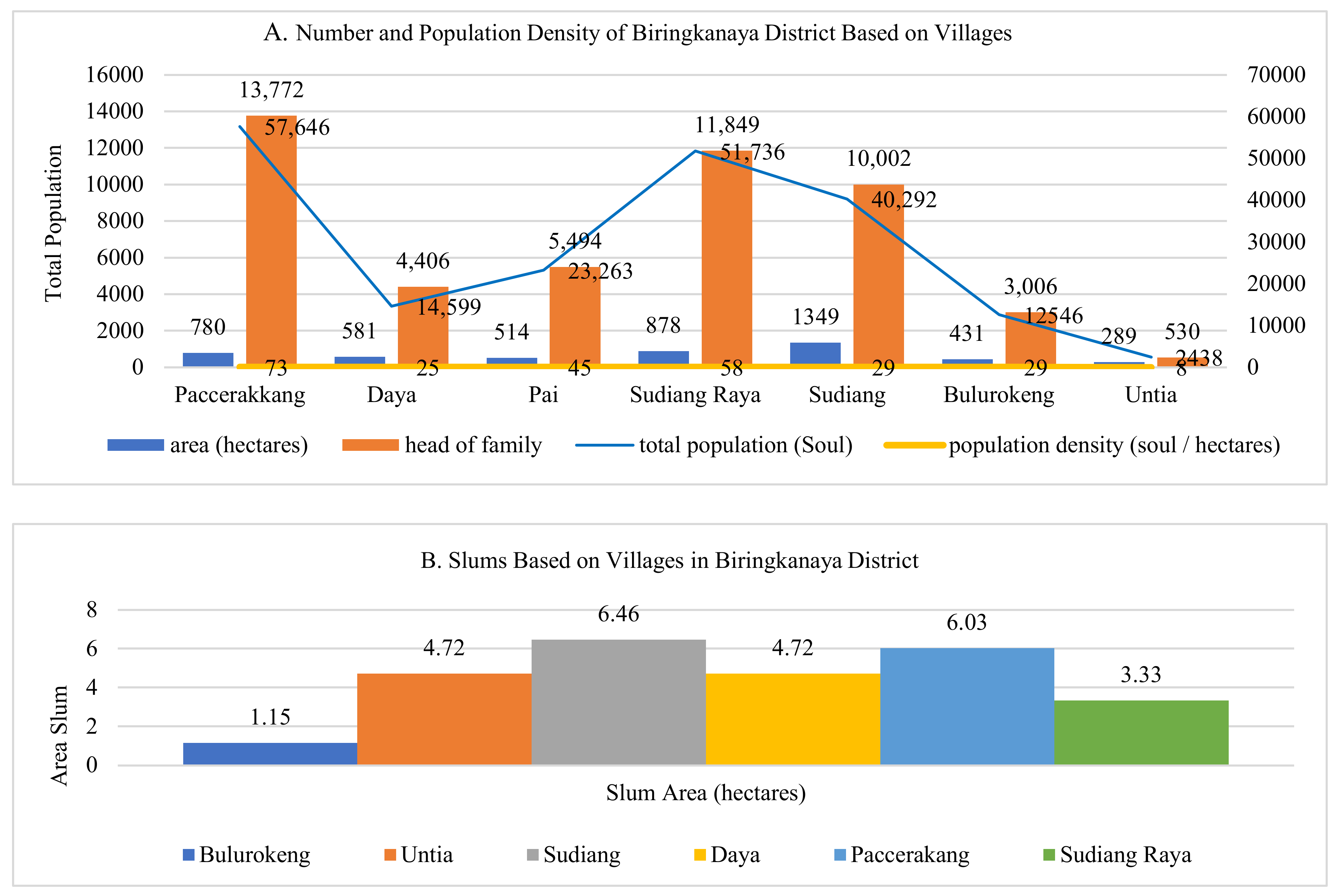
| Number | Village | Slum Area (Hectares) | Total Population (Soul) |
|---|---|---|---|
| 1 | Paccerakkang | 603 | 57,646 |
| 2 | Daya | 472 | 14,599 |
| 3 | Pai | - | 23,263 |
| 4 | Sudiang Raya | 333 | 51,736 |
| 5 | Sudiang | 646 | 40,292 |
| 6 | Bulurokeng | 115 | 12,546 |
| 7 | Untia | 472 | 2438 |
| Number | Village | Slum Area (Hectares) | Total Population (Soul) |
|---|---|---|---|
| 1 | Jongaya | 32 | 15,678 |
| 2 | Tanjung Merdeka | 1719 | 11,414 |
| 3 | Balang Baru | 1631 | 8949 |
| 4 | Barombong | 3053 | 13,276 |
| 5 | Maccini Sombala | 2429 | 22,584 |
| 6 | Mangasa | 2271 | 32,042 |
| 7 | Mannuruki | 416 | 12,082 |
| 8 | Pa’baeng-Baeng | 357 | 20,731 |
| 9 | Parang Tambung | 4284 | 42,396 |
| Slum | Number of Family Heads | Number of Samples |
|---|---|---|
| Bulurokeng | 3006 | 25 |
| Untia | 530 | 10 |
| Sudiang | 10,002 | 40 |
| Pai | 5494 | 35 |
| Daya | 4406 | 30 |
| Paccerakang | 13,772 | 45 |
| Sudiang Raya | 11,849 | 45 |
| Jongaya | 3932 | 25 |
| Tanjung Merdeka | 2216 | 15 |
| Balang Baru | 4018 | 30 |
| Barombong | 3105 | 25 |
| Maccini Sombala | 5185 | 35 |
| Mangasa | 10,348 | 45 |
| Mannuruki | 3583 | 25 |
| Pa’baeng-Baeng | 5059 | 35 |
| Parang Tambung | 9749 | 35 |
| Correlated Variables | r Count | r Table | Information | R2 |
|---|---|---|---|---|
| Spatial Expansion with the Development of Slum (ryx1) | 0.42 | 0.297 | Significant | 0.176 |
| Land Use Change with the Development of Slums (ryx2) | 0.45 | 0.297 | Significant | 0.203 |
| Increase in Population with the Development of Slums (ryx3) | 0.47 | 0.297 | Significant | 0.221 |
| Spatial Activity Patterns with the Development of Slum (ryx4) | 0.39 | 0.297 | Significant | 0.152 |
| Spatial Expansion, Land Use Change, Increase in Population with the Development of Slums (R) | 0.568 | f = 3.22 | Significant | 0.320 |
© 2020 by the authors. Licensee MDPI, Basel, Switzerland. This article is an open access article distributed under the terms and conditions of the Creative Commons Attribution (CC BY) license (http://creativecommons.org/licenses/by/4.0/).
Share and Cite
Surya, B.; Saleh, H.; Suriani, S.; Sakti, H.H.; Hadijah, H.; Idris, M. Environmental Pollution Control and Sustainability Management of Slum Settlements in Makassar City, South Sulawesi, Indonesia. Land 2020, 9, 279. https://0-doi-org.brum.beds.ac.uk/10.3390/land9090279
Surya B, Saleh H, Suriani S, Sakti HH, Hadijah H, Idris M. Environmental Pollution Control and Sustainability Management of Slum Settlements in Makassar City, South Sulawesi, Indonesia. Land. 2020; 9(9):279. https://0-doi-org.brum.beds.ac.uk/10.3390/land9090279
Chicago/Turabian StyleSurya, Batara, Haeruddin Saleh, Seri Suriani, Harry Hardian Sakti, Hadijah Hadijah, and Muhammad Idris. 2020. "Environmental Pollution Control and Sustainability Management of Slum Settlements in Makassar City, South Sulawesi, Indonesia" Land 9, no. 9: 279. https://0-doi-org.brum.beds.ac.uk/10.3390/land9090279