Study on the Spatial Restructuring of the Village System at the County Level Oriented toward the Rural Revitalization Strategy: A Case of Jintan District, Jiangsu Province


Abstract
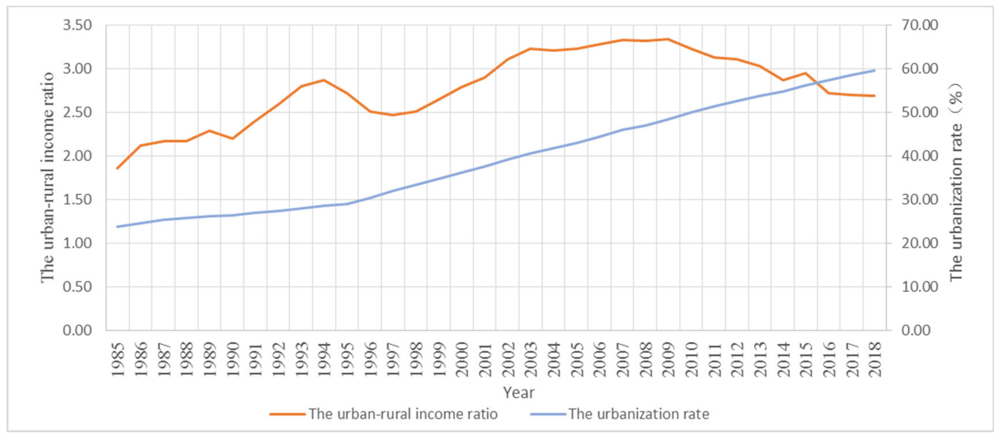
:1. Introduction
2. Methods for the Spatial Restructuring of the Village System
2.1. Village System Composition and Development Strategies
2.2. Village Centrality Index System and Evaluation Model
3. Study Area and Data Source
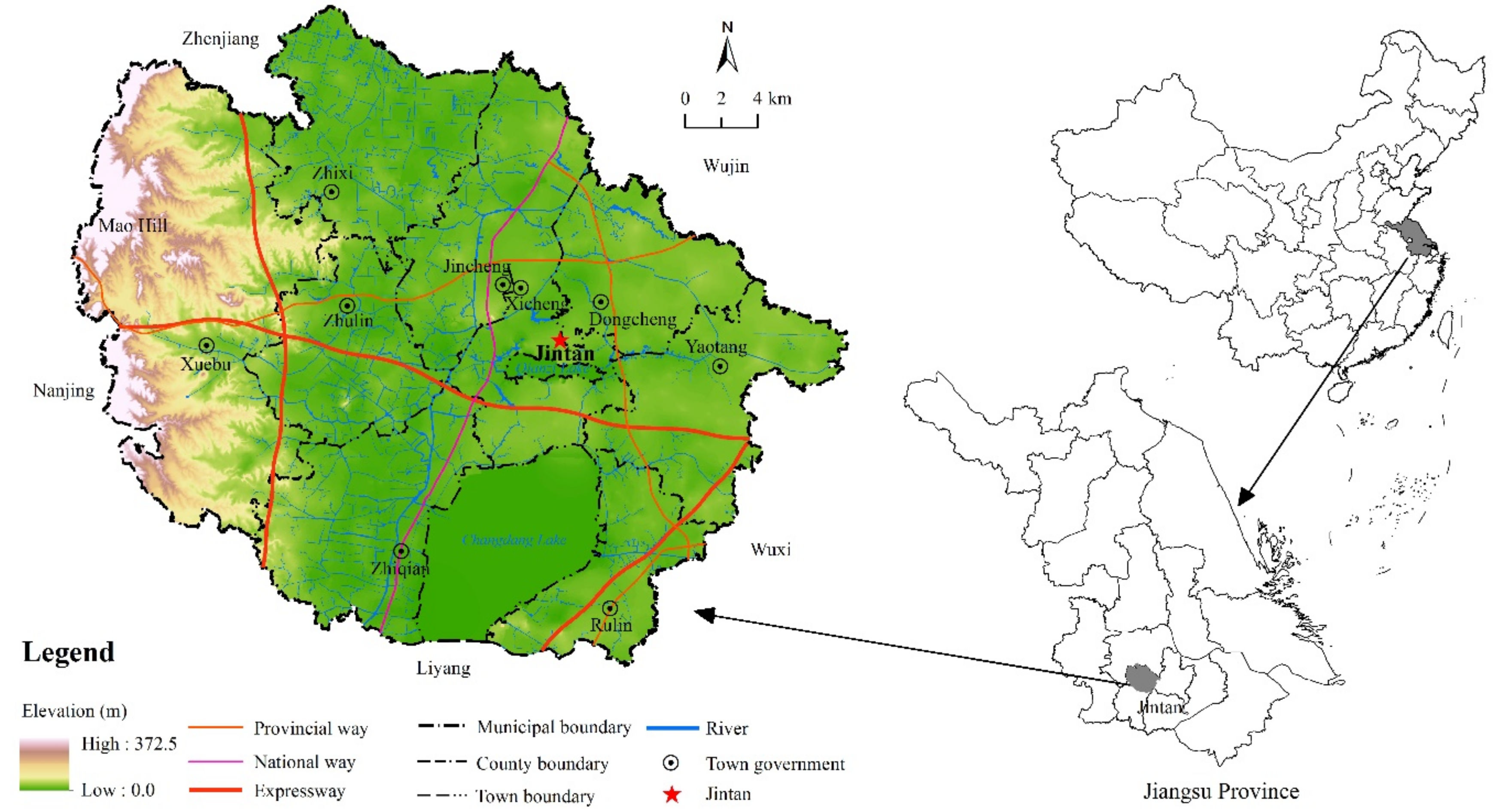
3.1. Overview of the Study Area
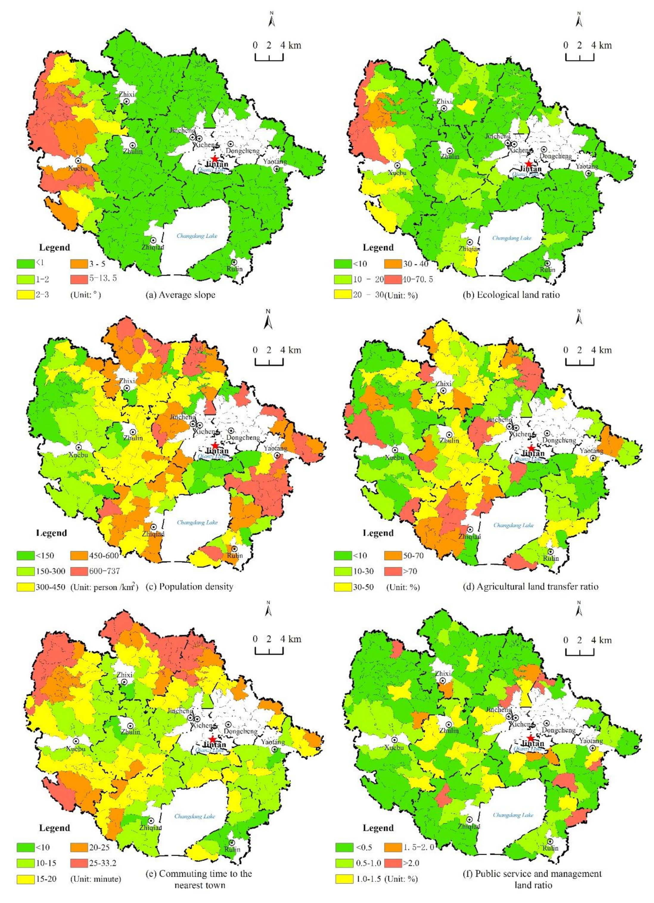
3.2. The Centrality Index and Data Source
4. Results and Discussion
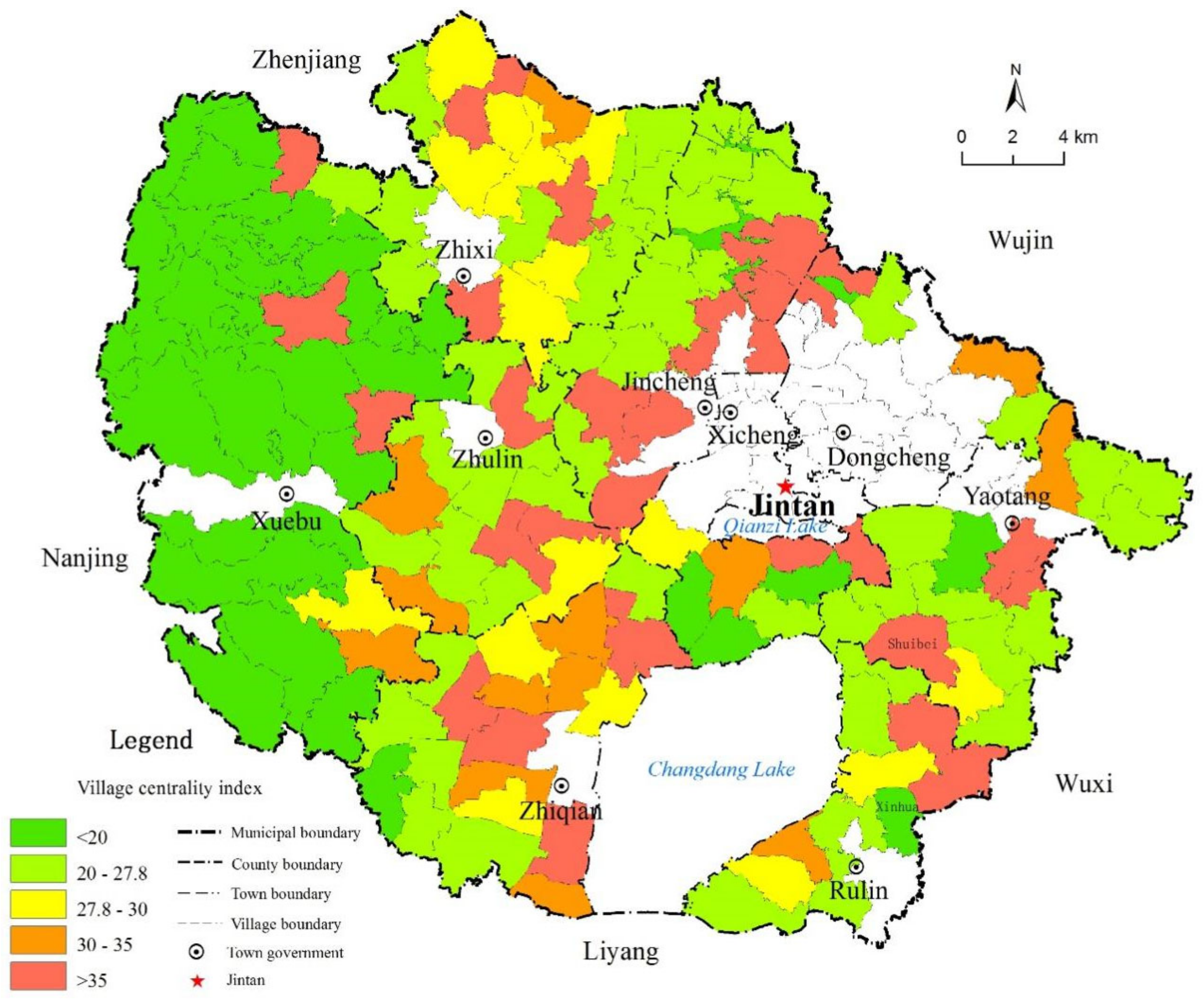
4.1. The Centrality of Villages in Jintan District
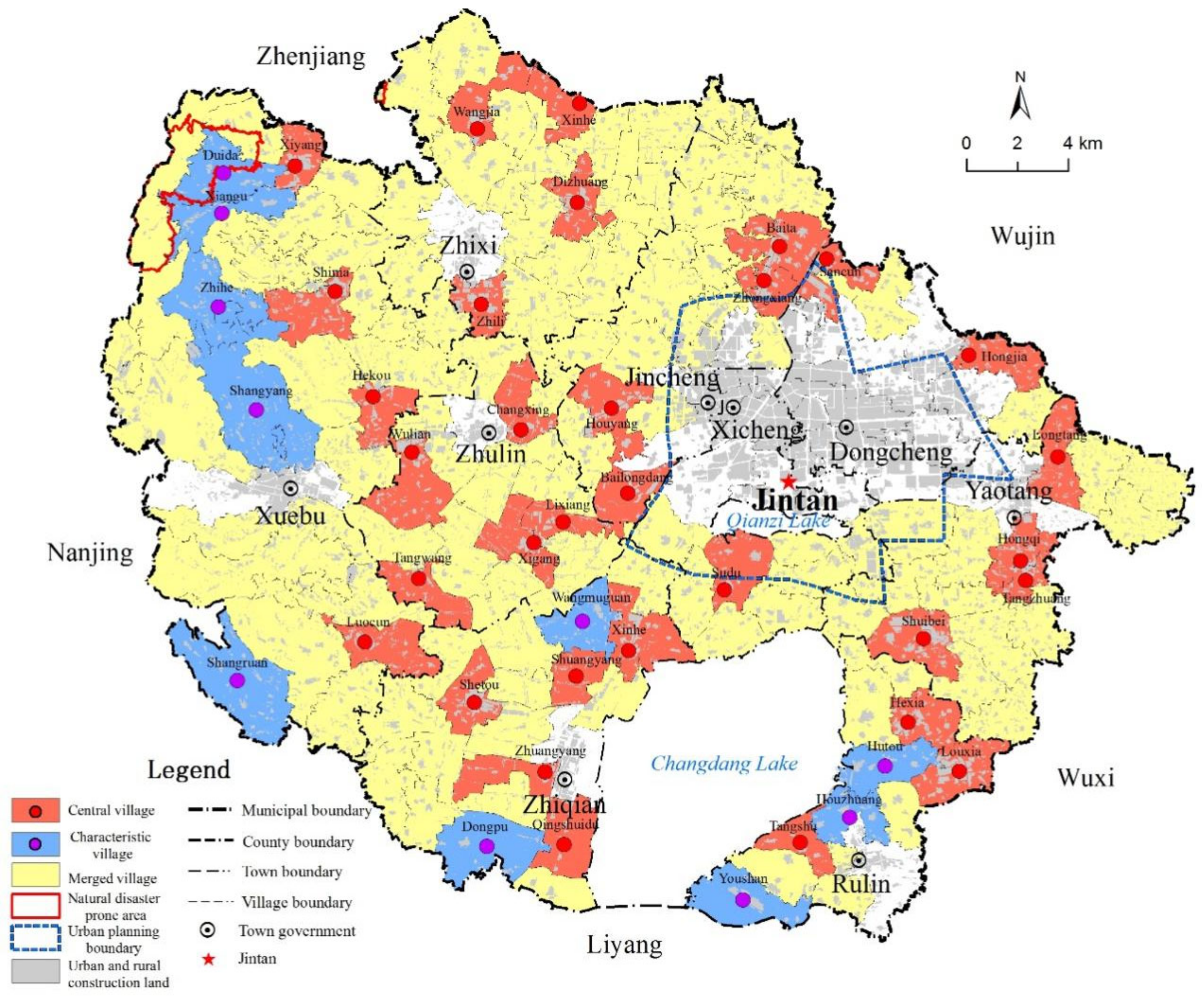
4.2. The Restructured Village System of Jintan District
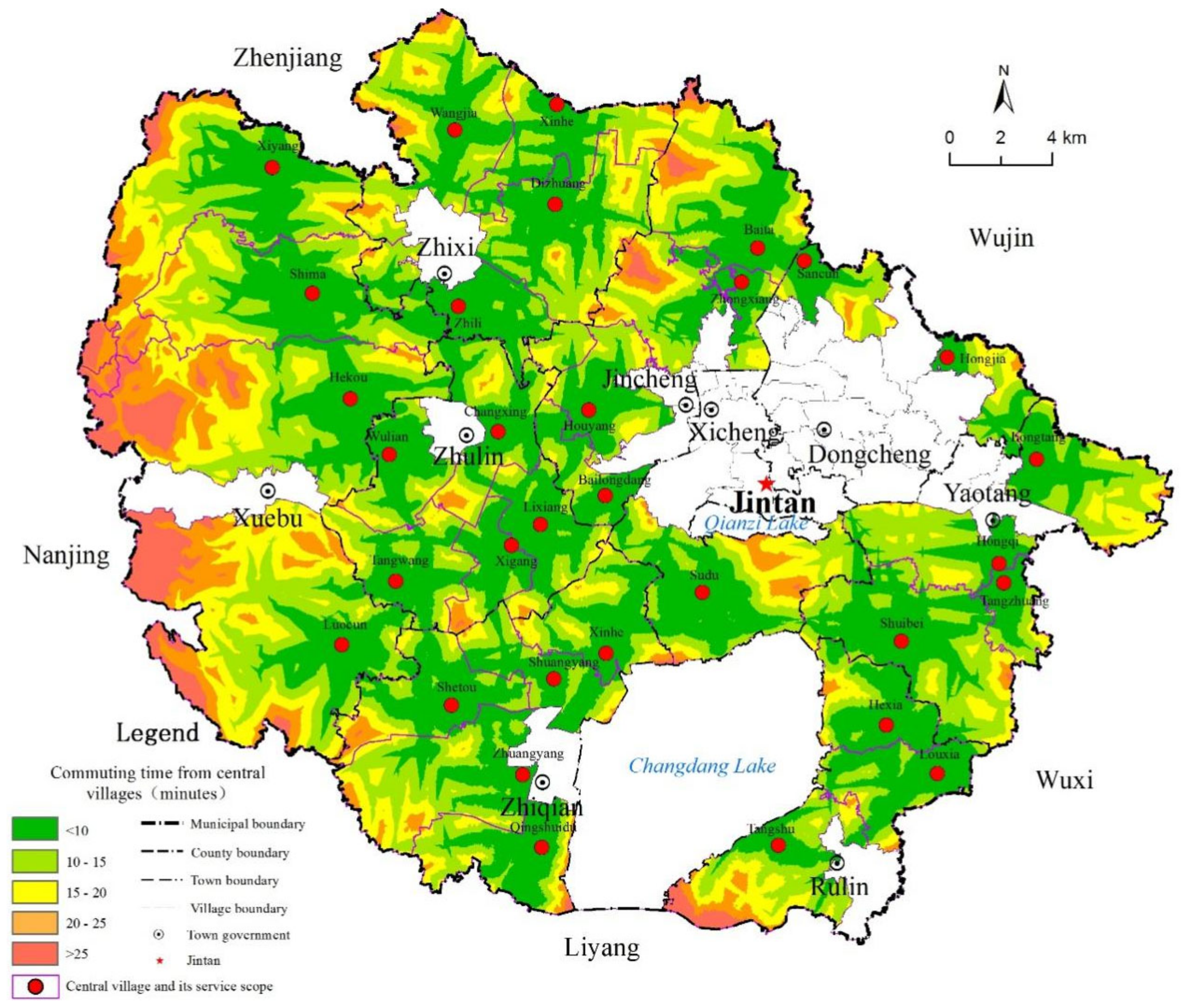
4.3. Analysis of the Layout Rationality of the Central Villages in Jintan District
4.4. Suggestions for the Implementation of the RRS in Jintan District
5. Conclusions and Future Work
Author Contributions
Funding
Conflicts of Interest
References
- Lin, Y.F. The “Rural, Agricultural and Farmer’s Problems” and the Rural Development in the Future. Issues Agric. Econ. 2003, 1, 19–24. (In Chinese) [Google Scholar]
- Justin, Y.L. Demystifying the Chinese Economy; Cambridge University Press: London, UK, 2014. [Google Scholar]
- Lin, H.L. Balancing Rural and Urban Development: Applying Coordinated Urban–Rural Development (CURD) Strategy to Achieve Sustainable Urbanization in China. Sustainability 2017, 9, 1948. [Google Scholar] [CrossRef] [Green Version]
- Hong, Y.X. The China Path to Economic Transition and Development; Springer: Singapore, 2016. [Google Scholar]
- Feng, Y.; Liu, Z.Y.; Wu, R.C. The Comparison and Inspiration of International Experience in Rural Revitalization: Taking Japan, South Korea and EU as Examples. World Agri. 2019, 1, 80–85. (In Chinese) [Google Scholar]
- Grant, W. The Common Agricultural Policy; Macmillan Press Ltd.: London, UK, 1997. [Google Scholar]
- Janet, D.; Neil, W.; Phillip, L.; David, B. European Rural Development under the Common Agricultural Policy’s ‘Second Pillar’: Institutional Conservatism and Innovation. Reg. Stud. 2007, 41, 873–887. [Google Scholar]
- Jung Won, S.; Dong-Wan, G. South Korea’s Saemaul (New Village) movement: An organisational technology for the production of developmentalist subjects. Can. J. Dev. Studies Rev. Can. Études Dév. 2013, 34, 22–36. [Google Scholar]
- Jwa, S.H. Understanding Korea’s Saemaul Undong: Theory, Evidence, and Implication. Seoul J. Econ. 2018, 31, 195–236. [Google Scholar]
- Odagiri, T. Rural Regeneration in Japan. Centre for Rural Economy Research Report; University of Newcastle upon Tyne: Newcastle upon Tyne, UK, 2011; Volume 242, p. 22. [Google Scholar]
- Mukai, K.; Fujikura, R. One village one product: Evaluations and lessons learnt from OVOP aid projects. Dev. Pract. 2015, 25, 389–400. [Google Scholar] [CrossRef]
- Ding, N. Urban-Rural Relation with Chinese Characteristics: Research on the Development from Dual Structure to Urban-Rural Integration; Jilin University: Changchun, China, 2019. (In Chinese) [Google Scholar]
- Li, J. Study on the Main Influence Factors and Countermeasures of Urban and Rural Residents Income Gap in China; Northeast Agricultural University: Harbin, China, 2017. (In Chinese) [Google Scholar]
- Pan, J.H.; Wei, H.K. Blue Book of Cities in China: Annual Report on Urban Development of China (No.2); Social Sciences Academic Press: Beijing, China, 2009. (In Chinese) [Google Scholar]
- Central Committee of the Communist Party of China. Opinions on Promoting the Construction of a New Socialist Countryside. Available online: http://www.gov.cn/gongbao/content/2006/content_254151.htm (accessed on 20 August 2020).
- Central Committee of the Communist Party of China. Opinions on Strengthening the Urban-Rural Coordinated Development and Further Consolidating the Foundation of Agricultural and Rural Development. Available online: http://www.gov.cn/gongbao/content/2010/content_1528900.htm (accessed on 20 August 2020).
- National Bureau of Statistics. China Statistical Yearbook (2019); China Statistics Press: Beijing, China, 2019. (In Chinese) [Google Scholar]
- Xi, J.P. Winning a Comprehensively Completed Well-off Society and Winning the Great Victory of Socialism with Chinese Characteristics in the New Era: Report at the 19th National Congress of the Communist Party of China; People’s Publishing House: Beijing, China, 2017. (In Chinese) [Google Scholar]
- Central Committee of the Communist Party of China. Opinions on Implementing the Rural Revitalization Strategy. Available online: http://www.gov.cn/zhengce/2018-02/04/content_5263807.htm (accessed on 20 August 2020).
- Gao, B.X.; Chen, G.S. The Merging Wave of Western Grassroots Government and its Inspiration to China. Social. Stud. 2006, 2, 96–100. (In Chinese) [Google Scholar]
- Albæk, E. Nordic Local Government: Developmental Trends and Reform Activities in the Postwar Period; Chang, Z.X., Translator; Peking University Press: Beijing, China, 2005. (In Chinese) [Google Scholar]
- Nie, Y.X.; Song, M.S. A Review of Research on “Village Merger” at Home and Abroad. J. Shandong Agric. Univ. Soc. Sci. Ed. 2015, 17, 73–78. (In Chinese) [Google Scholar]
- Tindal, C.R.; Tindal, S.N. Local Government in Canada, 6th ed.; Yu, X.M.; Deng, X., Translators; Peking University Press: Beijing, China, 2005. (In Chinese) [Google Scholar]
- Ostrom, V.; Bish, R.; Ostrom, E. Local Government in the United States; Jin, M.; Chen, Y.H., Translators; Peking University Press: Beijing, China, 2004. (In Chinese) [Google Scholar]
- Weese, E. Political mergers as coalition formation: An analysis of the Heisei municipal amalgamations. Quant. Econ. 2015, 6, 257–307. [Google Scholar] [CrossRef] [Green Version]
- The Japan Institute for Labour Policy and Training. Disparity, Poverty and Labor. Jpn. Labor Rev. 2008, 5, 4. [Google Scholar]
- Ministry of Construction of the People’s Republic of China. Standard for Planning of Town; China Construction Industry Press: Beijing, China, 2007. (In Chinese) [Google Scholar]
- Sun, J.X.; Lv, B.; Chen, R.; He, C.D. The Approach of Village System Spatial Restructuring on the Background of Urban-Rural Integration: A Case Study of Jiuduhe Town in Huairou District of Beijing. Urban Stud. 2009, 16, 75–81. (In Chinese) [Google Scholar]
- Chen, J.J.; Zhang, Y.; Bai, J.; Chen, L. Guidelines for the Preparation of Village Planning (Draft). J. Urban Reg. Plan. 2017, 9, 99–111. (In Chinese) [Google Scholar]
- Christaller, W. Central Places in Southern Germany; Baskin, C.W., Translator; Prentice Hall: London, UK, 1966. [Google Scholar]
- Li, G.P.; Zeng, G.; Tan, C.L. Economic Geography, 3rd ed.; Higher Education Press: Beijing, China, 2018. (In Chinese) [Google Scholar]
- Statistics Bureau of Jintan District. Statistical Yearbook of Jintan District (2019); China Statistics Press: Beijing, China, 2019. (In Chinese) [Google Scholar]
- People’s Government of Jintan District, Changzhou City. Jintan District City Master Plan (2013–2030). Available online: http://zrzy.jiangsu.gov.cn/gtapp/nrglIndex.action?type=2&messageID=ff80808171f24ff70171f767289c0231 (accessed on 20 August 2020).


| Condition | Determinants | Optional Evaluation Indicators | The Relationship between the Determinants and the Rural Revitalization Strategy (RRS) |
|---|---|---|---|
| Environmental conditions | Terrain | Average elevation, average slope | Reflects the basic conditions for the development of villages. For areas with large hills or mountains, the topographical condition is an important determinant of the choice of central villages, while for the plains, this factor can be ignored. |
| Ecological livability | Proportion of ecological land | Reflects the ecological livability of villages, and indicates the proportion of water areas, forest land and other ecological land in the area. | |
| Water source guarantee | Proportion of water area | Water sources are the lifeblood of rural areas and agricultural production. For water resource-constrained areas, the water source guarantee rate is an important determinant of central villages. For areas along a water network, this factor can be ignored. | |
| Natural disasters | Areas severely affected by natural disasters. | Various areas prone to natural disasters are automatically disqualified in the site selection of the central villages. | |
| Socioeconomic conditions | Demographic status | Population density | Reflects the village’s ability to attract residents. Villages with severe hollowing out and a sparse population are not suitable to be central villages. |
| Transportation accessibility | Commuting time to nearest town | Reflects the ease of transportation of the villages. Central villages are the links between the merged villages, the characteristic villages, and the towns, which requires that these villages are relatively easily accessible via transportation. | |
| Public management and services support | Proportion of public services and public management land | Convenient public services and management can attract residents to settle and help improve the quality of life of residents. | |
| Nonagricultural industry base | Proportion of collective commercial construction land | Reflects the basis for integrated development of the village industries. The larger the nonagricultural industry base is, the better the ability of the village to absorb population and to promote industrial agglomeration, and the more prominent the centrality of the village. | |
| The base for large-scale agricultural operations | Agricultural land contract management rights transfer ratio | Reflects the basic conditions for the development of modern agriculture in the village. A high transfer ratio of agricultural land contracted management rights provides a good foundation for large-scale operations, and these types of villages are more suitable to be merged villages. | |
| Degree of idle construction land | The proportion of idle rural construction land | Reflects the utilization rate of rural construction land. Villages with a high rate of idle rural construction land are not suitable to be central villages. |
| Transportation Types | Expressway | National Way | Provincial Way | County Road | Urban Road |
|---|---|---|---|---|---|
| Speed (km/h) | 120 | 80 | 60 | 40 | 20 |
Publisher’s Note: MDPI stays neutral with regard to jurisdictional claims in published maps and institutional affiliations. |
© 2020 by the authors. Licensee MDPI, Basel, Switzerland. This article is an open access article distributed under the terms and conditions of the Creative Commons Attribution (CC BY) license (http://creativecommons.org/licenses/by/4.0/).
Share and Cite
Bu, X.; Pu, L.; Shen, C.; Xie, X.; Xu, C. Study on the Spatial Restructuring of the Village System at the County Level Oriented toward the Rural Revitalization Strategy: A Case of Jintan District, Jiangsu Province. Land 2020, 9, 478. https://0-doi-org.brum.beds.ac.uk/10.3390/land9120478
Bu X, Pu L, Shen C, Xie X, Xu C. Study on the Spatial Restructuring of the Village System at the County Level Oriented toward the Rural Revitalization Strategy: A Case of Jintan District, Jiangsu Province. Land. 2020; 9(12):478. https://0-doi-org.brum.beds.ac.uk/10.3390/land9120478
Chicago/Turabian StyleBu, Xinguo, Lijie Pu, Chunzhu Shen, Xuefeng Xie, and Caiyao Xu. 2020. "Study on the Spatial Restructuring of the Village System at the County Level Oriented toward the Rural Revitalization Strategy: A Case of Jintan District, Jiangsu Province" Land 9, no. 12: 478. https://0-doi-org.brum.beds.ac.uk/10.3390/land9120478