
Natural Radionuclides in Soils of Natural-Technogenic Landscapes in the Impact Zone of Potassium Salt Mining

Institute of Natural Science, Perm State University, Genkel St. 4, 614068 Perm, Russia
*
Author to whom correspondence should be addressed.
Minerals 2022, 12(11), 1352; https://0-doi-org.brum.beds.ac.uk/10.3390/min12111352
Submission received: 7 September 2022
/
Revised: 7 October 2022
/
Accepted: 20 October 2022
/
Published: 25 October 2022
(This article belongs to the Special Issue Radionuclides and Radiation Exposure in Mine Sites)
Abstract
:This study considers the contents of natural radionuclides (226Ra, 232Th, and 40K) in the soils of natural–technogenic landscapes in the Verkhnekamskoe potassium–magnesium salt deposit (Perm Krai, Russia). The purpose of the study is to assess the lateral activity distribution of natural radionuclides (226Ra, 232Th, and 40K) in the soils of natural–technogenic landscapes of the mining areas on the territory of the Berezniki–Solikamsk industrial hub. Seventy-five soil samples from depths of 0–0.4 m are examined. The specific activities of the natural radionuclides 226Ra, 232Th, and 40K in the soil samples are measured using gamma spectrometry. The average values of the activity concentrations of 226Ra, 232Th, and 40K are 11.78 Bq/kg, 8.11 Bq/kg, and 246.9 Bq/kg, respectively. A gamma survey is conducted using the MKS/SRP-08A search dosimeter–radiometer over a control point framework covering 50,000 hectares. The research shows that the migration of the studied natural radionuclides is limited to a radius of 10 km. The results of the gamma-radiation measurements in the study area fall within a range of 0.06–0.25 µSv/h, which does not exceed the permissible limits. According to the findings, there is an increase in the concentration of natural radionuclides in transit supra-floodplain terrace landscapes and accumulative floodplain landscapes in the area affected by potash mining.
1. Introduction
Natural radionuclides have existed on Earth since its inception. They are distributed throughout the biosphere and accumulate in the atmosphere, soil, bottom sediments, water, and plants. The abiogenic cycle of radionuclide migration in the biosphere consists of three major stages: (1) matter mobilisation during rock weathering; (2) transfer by a transport medium; (3) sedimentation in local areas and final runoff reservoirs during transportation. The transportation process is the primary source of material that enters the biogenic cycle during soil formation processes [1]. There are numerous radionuclides in the environment containing uranium (U) radioisotopes, thorium (Th) radioisotopes, and natural 40K [2]. Cosmic radiation and radioactive elements in the Earth’s crust, water bodies, and atmosphere are the primary sources of the natural radiation background in any area [3]. 238U, 232Th, 226Ra, and 40K are the most common naturally occurring radioactive isotopes in the environment [3,4]. The natural radiation background varies depending on certain territorial aspects, including geological features such as the contents of thorium (Th), uranium (U), and potassium (K) in the rocks [5]; and geochemical features of radionuclide behaviour in different natural environments. The natural radionuclide activity concentrations in the soil range from micro- to thousands of becquerels per kilogram [6,7,8].
The radiation situation in any territory in modern conditions is formed by the natural and anthropogenic backgrounds. While radionuclides are formed naturally in soils and rocks as a result of radioactive decay, the majority of the environmental phenomena associated with radioactive contamination are caused by mineral extraction and processing. Mining is a considerable source of natural radioactivity [9]. The active development of industrial production resulted in radical changes in environmental conditions, particularly intense radioactive contamination of the main components of the natural environment (soils, natural waters, rocks, and bottom sediments) [10,11]. Natural radionuclides enter water bodies and accumulate in soils and bottom sediments as a result of migration. Their high concentrations can endanger the habitats of microorganisms, animals, and humans. Natural formations (rocks with a high content of natural radionuclides [12,13,14]), as well as the mining and processing of coal [15], oil [3], gas [16], and food salt [17,18,19], can be sources of natural radionuclides that are input into the environment. Mining waste can be a source of radiation [20,21].
Potash production waste is the primary source of environmental component contamination in the study area. The Berezniki–Solikamsk industrial hub is one of the most developed sites in the Verkhnekamskoe potassium–magnesium salt deposit (Verkhnekamskoe Salt Deposit) (Perm Krai, Russia). Environmental pollution caused by ore beneficiation waste is one of the issues posed by mining and processing. The majority of waste is dumped on the ground [22]. As a result of potassium ore enrichment, more than 270 million tonnes of halite waste and more than 30 million m3 of clay–salt slurry are stored on the surface in the development area of the Verkhnekamskoe Salt Deposit [23].
The technogenic impacts of potash production, together with a complex of regional conditions and ecological features of the study area, play an important role in the distribution and accumulation of natural radionuclides in soils of various landscape types. The level of soil radioactivity is an indicator for assessing the territory’s radioecological background [24,25].
The purpose of the study is to assess the lateral distribution of the activity of the natural radionuclides 226Ra, 232Th, and 40K in the soils of natural–technogenic mining areas within the Berezniki–Solikamsk industrial hub in the area affected by potash enterprises. Naturally, 40K is the most relevant of the natural radionuclides studied in the area.
2. Materials and Methods
The study area is located in the northern part of the Verkhnekamskoe Salt Deposit. Soil samples were collected at predetermined points throughout the territory, near mining operations and residential areas. Samples were taken from the upper soil layer at 0–0.4 m intervals. A total of 75 soil samples were collected and examined.
The soil samples were dried to air-dry at room temperature in the laboratory. Organic matter was removed from the dried samples. The samples were prepared for the examination of the specific activity of natural radionuclides (40K, 226Ra, and 232Th). An MKS-01A MULTIRAD device (Amplituda, Zelenograd, Russia) was used for the gamma spectrometry. The “Progress” software package (Amplituda, Zelenograd, Russia) was used to process the gamma spectra. The specific activity error range was approximately ±(20%–30%) of the measured values.
An energy calibration of the spectrometer was carried out with a 137Cs and 40K reference source. The source was a 1 L Marinelli beaker filled with KCl and sealed with a lid. The source had a cylindrical deepening area at the base with the fixed 137Cs source (a disc 29 mm in diameter with an active spot in the centre sealed with two 50-μm-thick polyamide films). The source activity was 1500 Bq, with 20% error at a confidence level of 0.95. The spectrum from the gamma spectrometer’s calibration source showed the maxima of the 137Cs (energy 662 keV) and 40K (energy 1461 keV) total absorption peaks, as well as the count rate in a specific energy range of 620–700 keV. After calibration, the background was measured (for 1800 s) to control the intrinsic noise of the gamma spectrometric tract and to record the contribution of the external gamma radiation to the device’s emission spectrum of the studied sample. The soil samples were placed in the Marinelli beaker up to a 1 L scale marking.
The allowable exposure standards for natural radionuclides were determined in accordance with the radiation safety standards. Their biological impact on the human body was also considered using the calculated value of the specific effective activity Aeff. This reflects the total specific activity of natural radionuclides in a studied material. It was calculated using the following formula:
where ARa and ATh are the specific activities of 226Ra and 232Th (Bq/kg), which are in equilibrium with the rest of the uranium and thorium series members, and AK is the specific activity of 40K (Bq/kg).
Aeff = ARa + 1.31ATh + 0.085AK
Because of the uneven distribution of natural radionuclides in the soil, the homogeneity of radiation exposure was measured based on the radium equivalent (Raeq) in Bq/kg to compare the specific activity levels of materials containing varying amounts of 226Ra, 232Th, and 40K [26,27,28]. The activity levels were calculated using the following formula:
Raeq = ARa + 1.43ATh + 0.077AK
As part of the gamma survey, reconnaissance was carried out. The natural conditions of the area were detailed, specifying the thickness and nature of the deposits, and the gamma background for the rocks was determined. The ambient dose equivalent rate of continuous gamma radiation was estimated during the gamma survey. A search dosimeter–radiometer MKS/SRP-08A (Amplituda, Zelenograd, Russia) was used.
The landscape structure of the study area was investigated using a landscape geochemical approach aimed at exploring the migration of natural radionuclides (40K, 226Ra, and 232Th) in a landscape. This approach considers the role of natural factors in the transformation of matter flows affected by the regional and local parameters of the area. This part of the study was based on landscape descriptions and soil sampling data from autonomous and secondary landscapes in key areas along the landscape’s geochemical profile. This profile reflects the successive changes in soils in middle taiga landscapes while considering the locations of potash industry facilities.
The maps were created using the ArcGIS software package (version 10.6.1, ESRI, Redlands, CA, USA) via interpolation.
3. Results and Discussion
Subsoil use has a large impact on the transformation of natural complexes. Mining has a long-term negative impact on the environment. The enrichment of ores and the storage of waste on the surface have a negative impact on the soil. This changes the chemical and physical properties of the soil and increases the contents of salts and microelements [29].
The study area is part of boreal East Europe’s middle taiga landscapes. They are located on the denudation plain of the Middle Cis–Urals within the eastern margin of the Russian Platform and the Ufa–Solikamsk depression of the Cis–Ural foredeep. The area consists of nearly horizontal Permian rocks that are covered by a thin layer of anthropogenic deposits [30,31]. These geosystems have been heavily impacted by anthropogenic activity over the last eight decades as a result of active mining.
The assessment of the environmental consequences of mining and the development of environmental protection measures are among the priority tasks aimed at ensuring both radiation protection for the population and the sustainable functioning of natural ecosystems. Soil is the main buffer of the natural environment, bearing the cumulative effect of long-term anthropogenic impacts [32,33,34]. The radiation characteristics of the upper soil layer (up to 5 cm) is the most important aspect in a soil analysis, since it takes on 95%–98% of the anthropogenic impact.
The average activity concentrations for 226Ra, 232Th, and 40K are 11.78 Bq/kg, 8.11 Bq/kg, and 246.9 Bq/kg, respectively, while the standard deviations are 7.26 Bq/kg, 6.51 Bq/kg, and 114.28 Bq/kg, respectively. Details are provided in Supplementary Table S1.
Table 1 shows the results of the natural radionuclide’s content measurements in the studied areas, as well as published data from around the world. The specific activity of 226Ra (ARa) found in the study area corresponds to the global average level and is closest to the levels found in Egypt and Brazil. In the study area, isolated cases of 226Ra exceeding the world average levels are found (noted exceedance is up to 9%), as well as isolated exceedances of the world average levels of 40K (exceedances range from 2 to 25%). At the same time, the 232Th activity (ATh) in the study area is significantly lower than the global average values and specific activity values for other studied areas of the world.
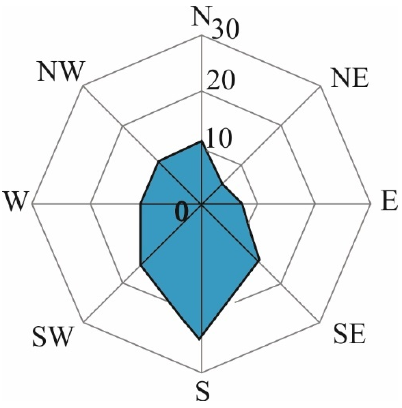
The average levels of 226Ra, 232Th, and 40K in the soils in the central part of the study area are 14 Bq/kg, 17 Bq/kg, and 369 Bq/kg, respectively. The formation of an area with higher concentrations of natural radionuclides is caused by meteorological conditions, specifically the wind regime of the study area. Southerly winds occur frequently throughout the year. Taking into account the prevailing wind direction, one can predict the considerable removal of elements with atmospheric flows in the northern direction (Figure 1).
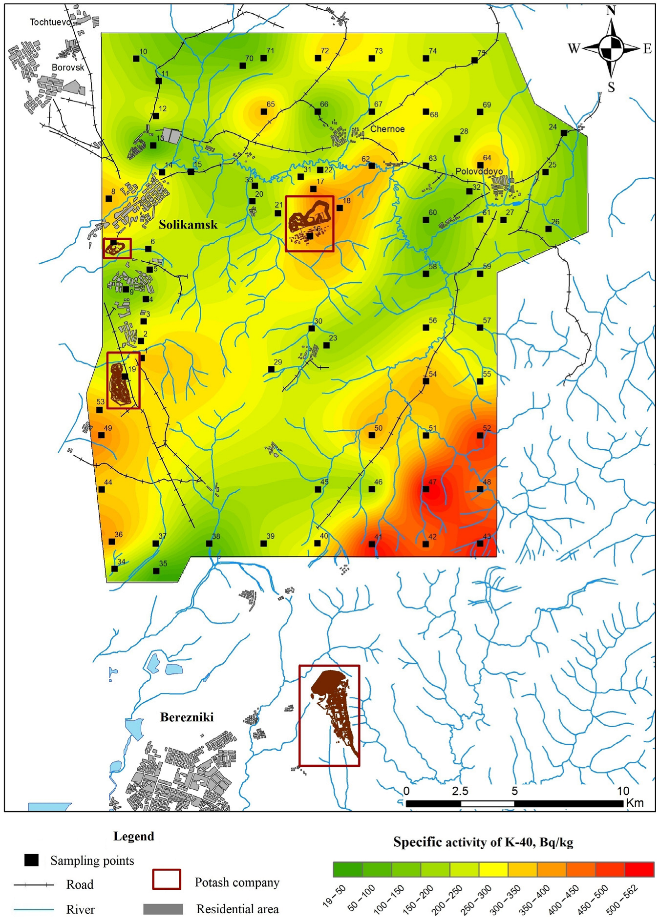
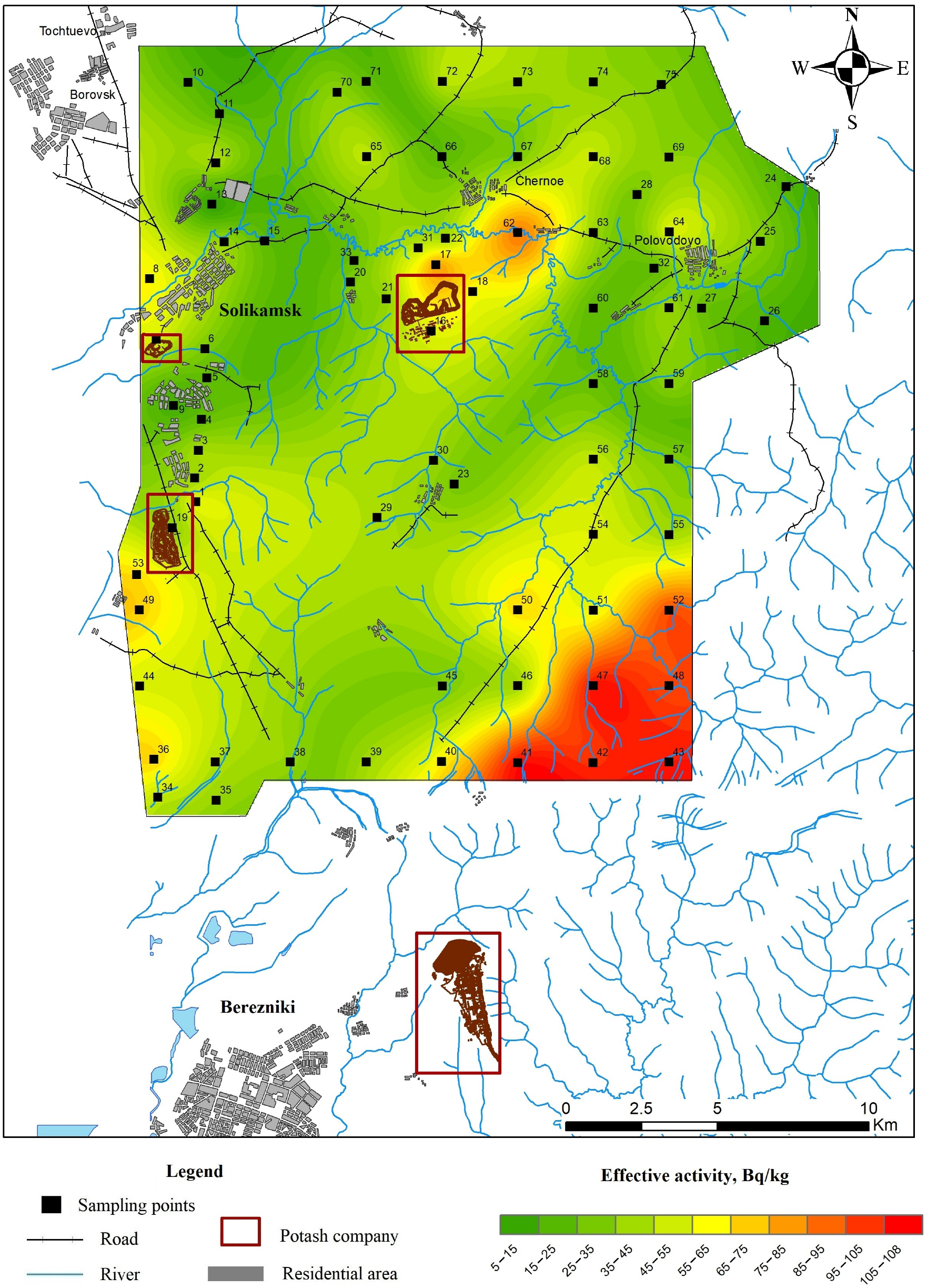
Increased values of the specific effective activity (Aeff) and specific activity of 40K were observed in the soils of the south-eastern part of the study area. This is associated with the transfer of the element by airflow in the northern and north-eastern directions from the potash mining territory located south of the study area (Figure 2 and Figure 3). This potash enterprise is distinguished by a higher volume of allowed potassium chloride emissions into the atmosphere and the high hypsometric position of the considered area.
The specific effective activity (Aeff) is one of the parameters describing the radiation situation. According to the published studies [35,36], the gradation of Aeff is defined by the following values (in Bq/kg) based on the level of danger: especially dangerous (more than 3300); dangerous (1101–3300); potentially dangerous (101–1100); safe (less than 100). The average value of the total specific effective activity of natural radionuclides for the soil in the study area is 43 Bq/kg, which corresponds to a safe level. At the same time, the obtained distribution pattern of the Aeff of the studied natural radionuclides corresponds to the distribution pattern of the 40K activity (Figure 2 and Figure 3).
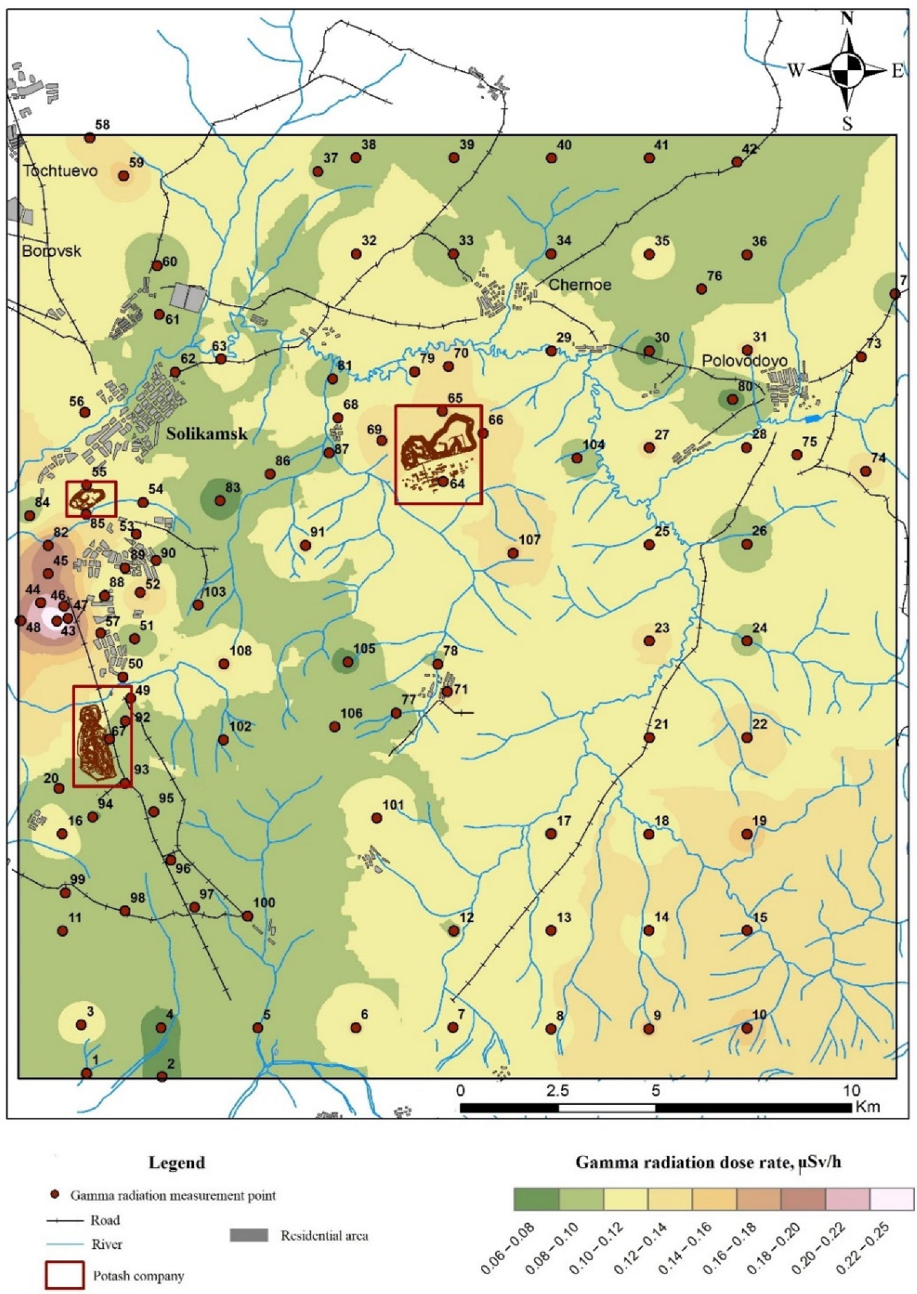
The results of the gamma radiation measurements in the study area fall within the range of 0.06–0.25 μSv/h (Figure 4), which is less than the established ambient dose equivalent rate of continuous gamma radiation for residential and industrial areas (0.3 and 0.6 μSv/h, respectively) [37].
The average radium equivalent activity concentration index (Raeq) for soils in the study area is 42.39 Bq/kg, which is less than the standard’s maximum allowable index (370 Bq/kg) [6]. Details are provided in Supplementary Table S1.

Table 1.
Summary of the natural radionuclide activity concentrations in soils within the study area and in other parts of the world in Bq/kg [6,38].
| Activity | Natural Radionuclide Activity in the Study Area (Mean Value for 75 Samples) | China [6] | USA [6] | Egypt [38] | Brazil [38] | Global Average Values [6] |
|---|---|---|---|---|---|---|
| A226Ra | 3–36 (17) | 1–360 | 4–130 | 31–40 | 29.2 | 16–116 (33) |
| A232Th | 1–28 (11) | 2–690 | 4–140 | 52–61 | 47.8 | 7–50 (45) |
| A40K | 20–562 (298) | 9–1800 | 100–700 | 3149–3210 | 704 | 100–700 (420) |
3.1. Natural Radionuclide Differentiation in the Middle Taiga Landscapes Based on the Potash Enterprise Location
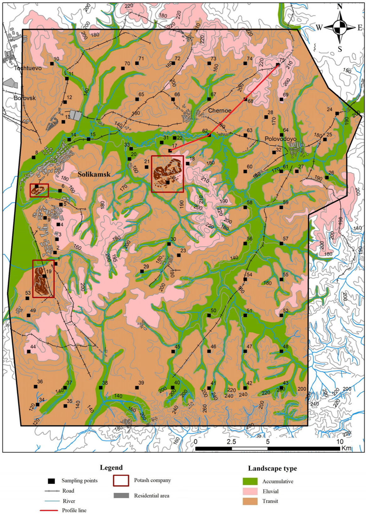
All geochemical processes that occur in landscapes are reflected in the soils. In the study area, alluvial and podzolic soils are developed under forest and grass communities within various types of landscapes. According to the geochemical map of the landscape (Figure 5) and the results of the specific efficiency analysis of natural radionuclides (Figure 3), the products of weathering and soil formation in an autonomous landscape come to the lower parts of the relief with the surface runoff and affect the formation of secondary surface and underwater landscapes. It is well known that radionuclide leaching is a common process in soils found in eluvial landscapes [39].
Additionally, there is a link between the distribution of various radionuclides in a landscape. This is especially noticeable in hydromorphic and semi-hydromorphic soils within accumulative landscapes. They are distinguished by a relatively higher accumulation of 226Ra compared to 232Th. Additionally, 226Ra is washed out of the upper horizons (A0, A1, and A2) and accumulated in illuvial horizon B. The podzolization and gleying processes lead to 226Ra and 232Th leaching from the upper horizons A1 and A2 and their accumulation in the illuvial horizon B and gley horizons G and Bg [1].
According to the research findings, there is an increase in the concentration of natural radionuclides in transit supra-floodplain terrace landscapes and accumulative floodplain landscapes within the area affected by potash mining. The distribution of 226Ra along the profiles of various soil types is nearly identical to that of 232Th. Increased contents of 226Ra and 232Th were observed in the floodplain soils of the study area (an accumulative type of element distribution), in the area affected by potash mining, and in residential areas. In accumulative landscapes, the average content of 226Ra (14 Bq/kg) is 1.4 times higher than the content of 232Th (10 Bq/kg). The average content of 226Ra is 8 Bq/kg in eluvial landscapes, 11 Bq/kg in transit landscapes, and 14 Bq/kg in accumulative landscapes. The average 232Th content is 6 Bq/kg in eluvial landscapes, 7 Bq/kg in transit landscapes, and 10 Bq/kg in accumulative landscapes (Table 2).
According to the findings [7], the activity concentration of 40K in the soil is an order of magnitude greater than for 232Th and 238U. The lateral distribution of 40K mostly depends on the anthropogenic factors, wind regime, landscape type, and geomorphological characteristics. Thus, the maximum concentrations of 40K in the study area were observed in areas affected by potash mining and other anthropogenic activities (including residential territories) (Figure 2). The highest average 40K content was found in accumulative landscapes, where it exceeded 279 Bq/kg (Table 2).
3.2. Lateral Distribution of Natural Radionuclides in Soils Affected by Potash Mining
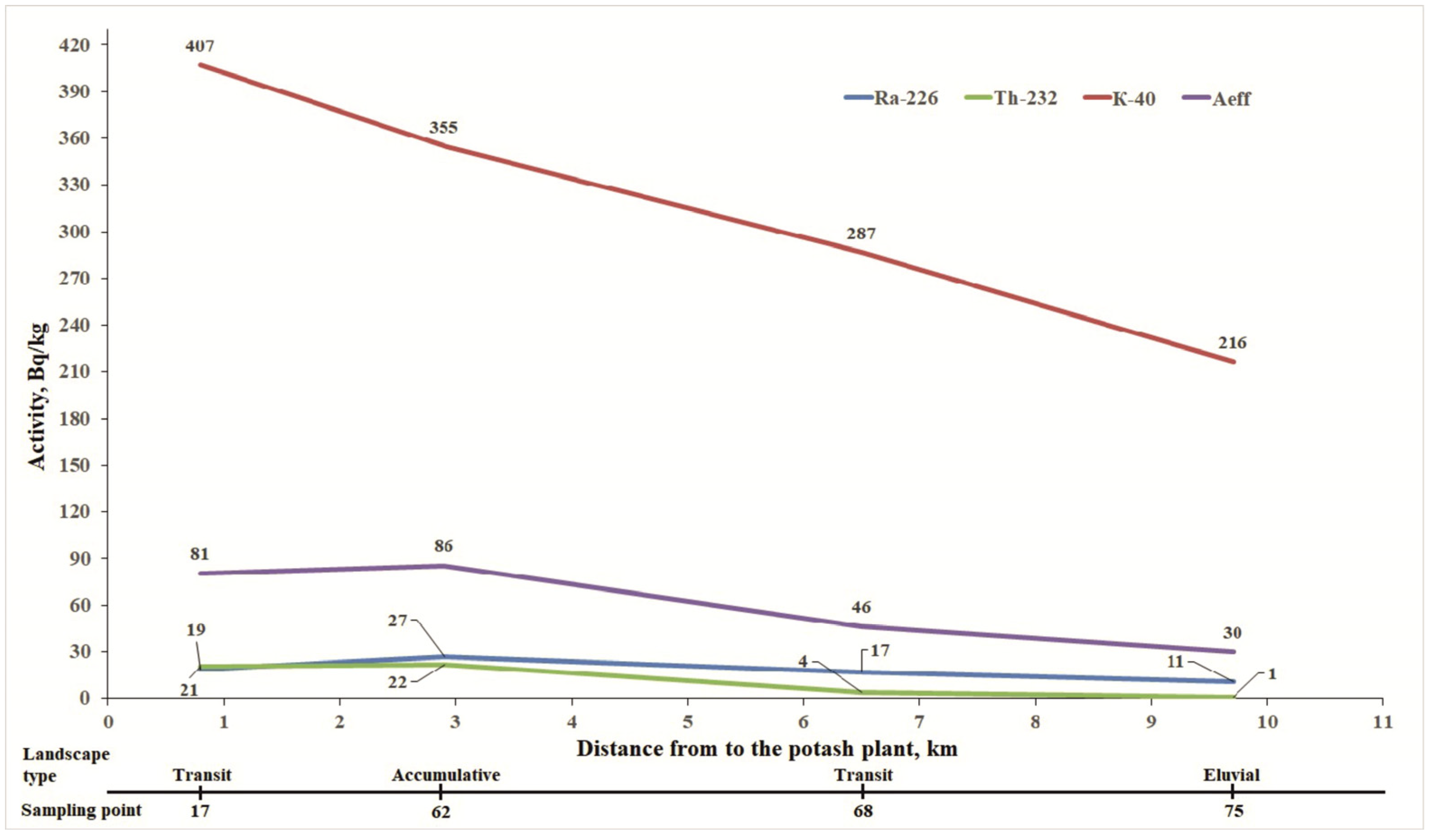
To study the distribution of natural radionuclides in the area affected by potash mining, soil sampling points were selected at various distances from the potash enterprise in the northern and north-eastern directions on various types of landscape (Figure 5). The data summary indicated the accumulative distribution of 226Ra, 232Th, and 40K in the soils affected by potash mining, taking into account the regional conditions. The highest contents of 226Ra (27 Bq/kg) and 232Th (22 Bq/kg) were recorded at point 62 (accumulative landscape) at a distance of 2.9 km from the industrial site to the north-east (Figure 5 and Figure 6). The contents of 226Ra, 232Th, and 40K decrease with distance from the enterprise. The maximum content of 40K (407 Bq/kg) was observed at a distance of 800 m from the potassium plant within the transit landscape, which is determined here by the active atmochemical impact of the potassium plant.
4. Conclusions
The research findings show that the study area in the Berezniki–Solikamsk industrial hub affected by the Verkhnekamskoe Salt Deposit’s development does not have a impact on the radiation situation. The 226Ra, 232Th, and 40K activities in the top soil layers range from 3 to 36 Bq/kg, from 1 to 28 Bq/kg, and from 20 to 562 Bq/kg, respectively. These levels do not exceed the global average values. The results of the gamma-radiation measurements in the study area range from 0.06 to 0.25 μSv/h, which is less than the established ambient dose equivalent rates of continuous gamma-radiation in residential and industrial areas (0.3 and 0.6 μSv/h, respectively). The average Aeff index for the soil within the study area corresponds to the safe level.
The lateral activity distribution analysis of the natural radionuclides 226Ra, 232Th, and 40K showed elevated 226Ra and 232Th contents in the floodplain soils and mining-affected areas of the natural–technogenic landscapes within the Berezniki–Solikamsk industrial hub. The effects of the potassium enterprises, the wind regime of the territory, the genetic type of the landscape, and geomorphological characteristics all have a great impact on the lateral distribution of 40K. From the research, we found the accumulative distribution of 226Ra, 232Th, and 40K in soils affected by potassium salt mining enterprises, considering the regional conditions. The future research will be focused on examining the distribution of natural radionuclides in soil horizons within areas with the highest concentrations.
The obtained results provide useful information on the natural radionuclide content in the area affected by mining facilities. The research findings are useful for a comparative assessment of the contribution of potash mining to the radiation situation of an area, considering the landscape’s structure.
The research findings can be used in radiation monitoring and developing practical recommendations to improve the ecological situation of a territory. Thus, a joint analysis of the natural radionuclide content and the landscape structure of a territory may serve as the basis for planning the survey grid when conducting monitoring studies of anthropogenic impacts.
Supplementary Materials
The following supporting information can be downloaded at: https://0-www-mdpi-com.brum.beds.ac.uk/article/10.3390/min12111352/s1, Table S1. Activity concentrations of 226Ra, 232Th 40K and Aeff in soil samples.
Author Contributions
Conceptualization, R.P. and E.M.; methodology, R.P.; software, R.P.; validation, E.M., R.P. and A.P.; formal analysis, A.P.; investigation, R.P.; resources, R.P.; data curation, E.M.; writing—original draft preparation, A.P.; writing—review and editing, E.M.; visualization, R.P.; supervision, E.M.; project administration, E.M.; funding acquisition, E.M. All authors have read and agreed to the published version of the manuscript.
Funding
This research was funded by the Perm Scientific and Educational Centre “Rational Subsoil Use”, 2022.
Data Availability Statement
Not applicable.
Conflicts of Interest
The authors declare no conflict of interest.
References
- Titaeva, N.A.; Taskaev, A.I. Migration of Heavy Natural Radionuclides in Conditions of Humid Zone; Nauka: Leningrad, Russia, 1984; 232p. [Google Scholar]
- Değerlier, M.; Karahan, G.; Ozger, G. Radioactivity concentrations and dose assessment for soil samples around Adana, Turkey. J. Environ. Radioact. 2008, 99, 1018–1025. [Google Scholar] [CrossRef] [PubMed]
- Perevoshchikov, R.D. Natural radionuclides (40K, 226Ra, 232Th) in depositing media (Verkhnekamskoye potassium-magnesium salt deposit area). Proceedings of Tomsk Polytechnic University. Eng. Georesour. 2022, 333, 29–38. [Google Scholar]
- Menshikova, E.A.; Perevoshchikov, R.D.; Belkin, P.A.; Blinov, S.M. Concentrations of Natural Radionuclides (40K, 226Ra, 232Th) at the Potash Salts Deposit. J. Ecol. Eng. 2021, 22, 179–187. [Google Scholar] [CrossRef]
- Al-Jundi, J.; Al-Bataina, B.A.; Abu-Rukah, Y.; Shehadeh, H.M. Natural radioactivity concentrations in soil samples along the Amman Aqaba highway, Jordan. Rad Meas. 2003, 36, 555–560. [Google Scholar] [CrossRef]
- UNSCEAR. Sources, effects and risks of ionizing radiation. In Report to the General Assembly, with Annexes; United Nations Publication: New York, NY, USA, 2000; 659p. [Google Scholar]
- UNSCEAR. Sources, effects and risks of ionizing radiation. In Report to the General Assembly, with Annexes; United Nations Publication: New York, NY, USA, 1993; 56p. [Google Scholar]
- Patiris, D.L.; Tsabaris, C.; Anagnostou, C.L.; Androulakaki, E.G.; Pappa, F.K.; Eleftheriou, G.; Sgouros, G. Activity concentration and spatial distribution of radionuclides in marine sediments close to the estuary of Shatt al-Arab/Arvand Rud River, the Gulf. J. Environ. Radioact. 2016, 157, 1–15. [Google Scholar] [CrossRef] [PubMed]
- Hector, M.C.; Angel, F.; Raquel, A. Heavy metal accumulation and tolerance in plants from mine tailings of the semiarid Cartagena-La Union mining district (SE Spain). Sci. Total Environ. 2006, 366, 1–11. [Google Scholar]
- Yan, L.; van Le, Q.; Sonne, C.; Yang, Y.; Yang, H.; Gu, H.; Ma, N.L.; Lam, S.S.; Peng, W. Phytoremediation of radionuclides in soil, sediments and water. J. Hazard. Mater. 2021, 407, 124771. [Google Scholar] [CrossRef]
- Liu, J.; Peng, A.; Deng, S.; Liu, M.; Liu, G.; Li, C. Distribution of heavy metals and radionuclides in the sediments and their environmental impacts in Nansha Sea area, South China Sea. Mar. Pollut. Bull. 2021, 166, 112192. [Google Scholar] [CrossRef]
- Khater, A.E.M.; Al-Mobark, L.H.; Aly, A.A.; Al-Omran, A.M. Natural radionuclides in clay deposits: Concentration and dose assessment. Radiat. Prot. Dosim. 2013, 156, 321–330. [Google Scholar] [CrossRef]
- Srinivasa, E.; Rangaswamy, D.R.; Sannappa, J. Assessment of radiological hazards and effective dose from natural radioactivity in rock samples of Hassan district, Karnataka, India. Environ. Earth Sci. 2019, 78, 431. [Google Scholar] [CrossRef]
- Yang, J.; Sun, Y. Natural radioactivity and dose assessment in surface soil from Guangdong, a high background radiation province in China. J. Radiat. Res. Appl. Sci. 2022, 15, 145–151. [Google Scholar] [CrossRef]
- Kozlowska, B.; Walencik, A.; Dorda, J.; Zipper, W. Radioactivity of dumps in mining areas of the Upper Silesian Coal Basin in Poland. EPJ Web Conf. 2012, 24, 05006. [Google Scholar] [CrossRef]
- Nowak, J.; Jodłowski, P.; Macuda, J.; Nguyen Dinh, C. Radiological Hazard Related with Natural Radioactivity in Natural Gas Transportation—A Case Study from Poland. Minerals 2022, 12, 662. [Google Scholar] [CrossRef]
- Caridi, F.; D’Agostino, M.; Marguccio, S.; Belvedere, A.; Belmusto, G.; Marcianò, G.; Sabatino, G.; Mottese, A. Radioactivity, granulometric and elemental analysis of river sediments samples from the coast of Calabria, south of Italy. Eur. Phys. J. Plus 2016, 131, 136. [Google Scholar] [CrossRef]
- Caridi, F.; Messina, M.; Belvedere, A.; D’Agostino, M.; Marguccio, S.; Settineri, L.; Belmusto, G. Food salt characterization in terms of radioactivity and metals contamination. Appl. Sci. 2019, 9, 2882. [Google Scholar] [CrossRef] [Green Version]
- Tahir, S.N.A.; Alaamer, A.S. Determination of natural radioactivity in rock salt and radiation doses due to its ingestion. J. Radiol. Prot. 2008, 28, 233–236. [Google Scholar] [CrossRef] [PubMed]
- International Atomic Energy Agency. Extent of Environmental Contamination by Naturally Occurring Radioactive Material (NORM) and Technological Options for Mitigation; Technical Report; IAEA: Vienna, Austria, 2003; pp. 1–3. [Google Scholar]
- Guerrero, J.L.; Gutiérrez-Álvarez, I.; Mosqueda, F.; Gázquez, M.J.; García-Tenorio, R.; Olías, M.; Bolívar, J.P. Evaluation of the radioactive pollution in the salt-marshes under a phosphogypsum stack system. Environ. Pollut. 2020, 258, 113729. [Google Scholar] [CrossRef]
- Ministry of Ecology, Energy, Development, Sustainable Development and Measures, Tour Sequoia, 92055 La Defense CEDEX (France); European Commission, Rue de la Loi/Wetstraat 170, B-1049 Bruxelles (Belgium). Reference Document on Best Available Techniques for Management of Tailings and Waste-Rock in Mining Activities; European Commission: Paris, France, 2009. [Google Scholar]
- Khayrulina, E.A.; Maksimovich, N.G. Influence of drainage with high contents of water-soluble salts on the environment in the Verhnekamskoe potash deposit, Russia. Mine Water Environ. 2018, 37, 595–603. [Google Scholar] [CrossRef]
- Bashie, E.H.; Salih, I.; Sam, A.K. GIS predictive mapping of terrestrial gamma radiation in the Northern State, Sudan. Radiat. Prot. Dosim. 2012, 151, 500–510. [Google Scholar]
- Idriss, H.; Salih, I.; Alaamer, A.S.; AL-Rajhi, M.A.; Osman, A.; Adreani, T.E.; Abdelgalil, M.; Ali, N.I. Health risk profile for terrestrial radionuclides in soil around artisanal gold mining area at Alsopag, Sudan. Acta Geophys. 2018, 66, 673–681. [Google Scholar] [CrossRef]
- Uosif, M.A.M.; Issa, S.A.M.; El-Salam, L.M.A. Measurement of natural radioactivity in granitesand its quartz-bearing gold at El-Fawakhir area (Central Eastern Desert), Egypt. J. Radiat. Res. Appl. Sci. 2015, 8, 393–398. [Google Scholar] [CrossRef] [Green Version]
- Laniyan, T.A.; Adewumi, A.J. Health risk profile of natural radionuclides in soils, sediments, tailings, and rocks around mining sites in Nigeria. Environ. Earth Sci. 2021, 80, 375. [Google Scholar] [CrossRef]
- Gonzalez-Fernandez, D.; Garrido-Perez, M.C.; Casas-Ruiz, M.; Barbero, L.; Nebot-Sanz, E. Radiological risk assessment of naturally occurring radioactive materials in marine sediments and its application in industrialized coastal areas: Bay of Algeciras, Spain. Environ. Earth Sci. 2012, 66, 1175–1181. [Google Scholar] [CrossRef]
- Khayrulina, E.; Mitrakova, N.; Poroshina, N.; Menshikova, E.; Perminova, A. Formation of solonchak in the area of the discharged ancient brine wells (Perm krai, Russia). Front. Environ. Sci. 2022, 10, 858742. [Google Scholar] [CrossRef]
- Voronov, G.A.; Tsiberkin, N.G.; Stenno, S.P. Landscape features of Perm Krai and prospects for designation of specially protected natural territories. Bull. Udmurt Univ. Biol. Earth Sci. 2008, 1, 3–18. [Google Scholar]
- Samofalova, I.A.; Kondratyeva, M.A. Landscape Science: Landscape-Ecological Analysis of the Territory; Study Guide; Ministry of Agriculture of the Russian Federation, Federal State Budgetary Educational Institution of Higher Education “Perm State Agrarian and Technological University named after Academician D.N. Pryanishnikov”: Perm, Russia, 2021; 99p. [Google Scholar]
- Singh, S.; Rani, A.; Mahajan, R.K. 226Ra, 232Th and 40K analysis in soil samples from some areas of Punjab and Himachal Pradesh, India using gamma ray spectrometry. Radiat. Meas. 2005, 39, 431–439. [Google Scholar] [CrossRef]
- Yang, Y.-X.; Wu, X.-M.; Jiang, Z.-Y.; Wang, W.-X.; Lu, J.-G.; Lin, J.; Wang, L.-M.; Hsia, Y.-F. Radioactivity concentrations in soils of the Xiazhuang Granite Area, China. Appl. Radiat. Isot. 2005, 63, 255–259. [Google Scholar] [CrossRef]
- Grebenshchikova, V.I.; Gritsko, P.P.; Kuznetsov, P.V.; Doroshkov, A.A. Uranium and thorium in soil cover of Irkutsk-Angarsk industrial zone (Baikal region). Proc. Tomsk. Polytech. Univ. 2017, 328, 93–104. [Google Scholar]
- Rikhvanov, L.P. Radioactive Elements in the Environment and Problems of Radioecology; Scientific & Technical Translatios: Tomsk, Russia, 2009; 429p. [Google Scholar]
- Khaykovich, I.M.; Mats, N.A.; Kharlamov, M.G. Classification of solid mineral. Reg. Geol. Metallog. 1999, 8, 131–140. [Google Scholar]
- Radiation Control and Sanitary-Epidemiological Assessment of Land for the Construction of Residential Buildings, Buildings and Structures of Public and Industrial Use in Terms of Radiation Safety (MU 2.6.1. 2398-08); Federal Centre for Hygiene and Epidemiology Rospotrebnadzor: Moscow, Russia, 2009. (In Russian)
- Nguelem, E.J.M.; Ndontchueng, M.M.; Motapon, O. Determination of 226Ra, 232Th, 40K, 235U and 238U activity concentration and public dose assessment in soil samples from bauxite core deposits in Western Cameroon. SpringerPlus 2016, 5, 1253. [Google Scholar] [CrossRef]
- Perelman, A.I.; Kasimov, N.S. Geochemistry of Landscape; Moscow State University: Moscow, Russia, 1999; 610p. [Google Scholar]
Figure 1.
Wind activity in the study area.

Figure 2.
Map of the specific activity of 40K in soils within the study area.

Figure 3.
Map of the specific effective activity (Aeff) in soils within the study area.

Figure 4.
Map of the gamma background of the study area.

Figure 5.
Landscape map of the study area.

Figure 6.
Distribution graph of 226Ra, 232Th, 40K, and Aeff at points 17, 62, 68, and 75.

Table 2.
Average contents of natural radionuclides in different landscapes within the study area in Bq/kg.
Table 2.
Average contents of natural radionuclides in different landscapes within the study area in Bq/kg.
| Activity | Type of Landscape | ||
|---|---|---|---|
| Eluvial | Transit | Accumulative | |
| ARa | 8 | 11 | 14 |
| ATh | 6 | 7 | 10 |
| AK | 247 | 225 | 279 |
Publisher’s Note: MDPI stays neutral with regard to jurisdictional claims in published maps and institutional affiliations. |
© 2022 by the authors. Licensee MDPI, Basel, Switzerland. This article is an open access article distributed under the terms and conditions of the Creative Commons Attribution (CC BY) license (https://creativecommons.org/licenses/by/4.0/).
Share and Cite
MDPI and ACS Style
Perevoshchikov, R.; Perminova, A.; Menshikova, E. Natural Radionuclides in Soils of Natural-Technogenic Landscapes in the Impact Zone of Potassium Salt Mining. Minerals 2022, 12, 1352. https://0-doi-org.brum.beds.ac.uk/10.3390/min12111352
AMA Style
Perevoshchikov R, Perminova A, Menshikova E. Natural Radionuclides in Soils of Natural-Technogenic Landscapes in the Impact Zone of Potassium Salt Mining. Minerals. 2022; 12(11):1352. https://0-doi-org.brum.beds.ac.uk/10.3390/min12111352
Chicago/Turabian StylePerevoshchikov, Roman, Anna Perminova, and Elena Menshikova. 2022. "Natural Radionuclides in Soils of Natural-Technogenic Landscapes in the Impact Zone of Potassium Salt Mining" Minerals 12, no. 11: 1352. https://0-doi-org.brum.beds.ac.uk/10.3390/min12111352
Note that from the first issue of 2016, this journal uses article numbers instead of page numbers. See further details here.