When the River Began—The Formation of River Motala Ström and Human Presence in the Early Holocene, Sweden

 , ,
, ,
Abstract
:1. Introduction
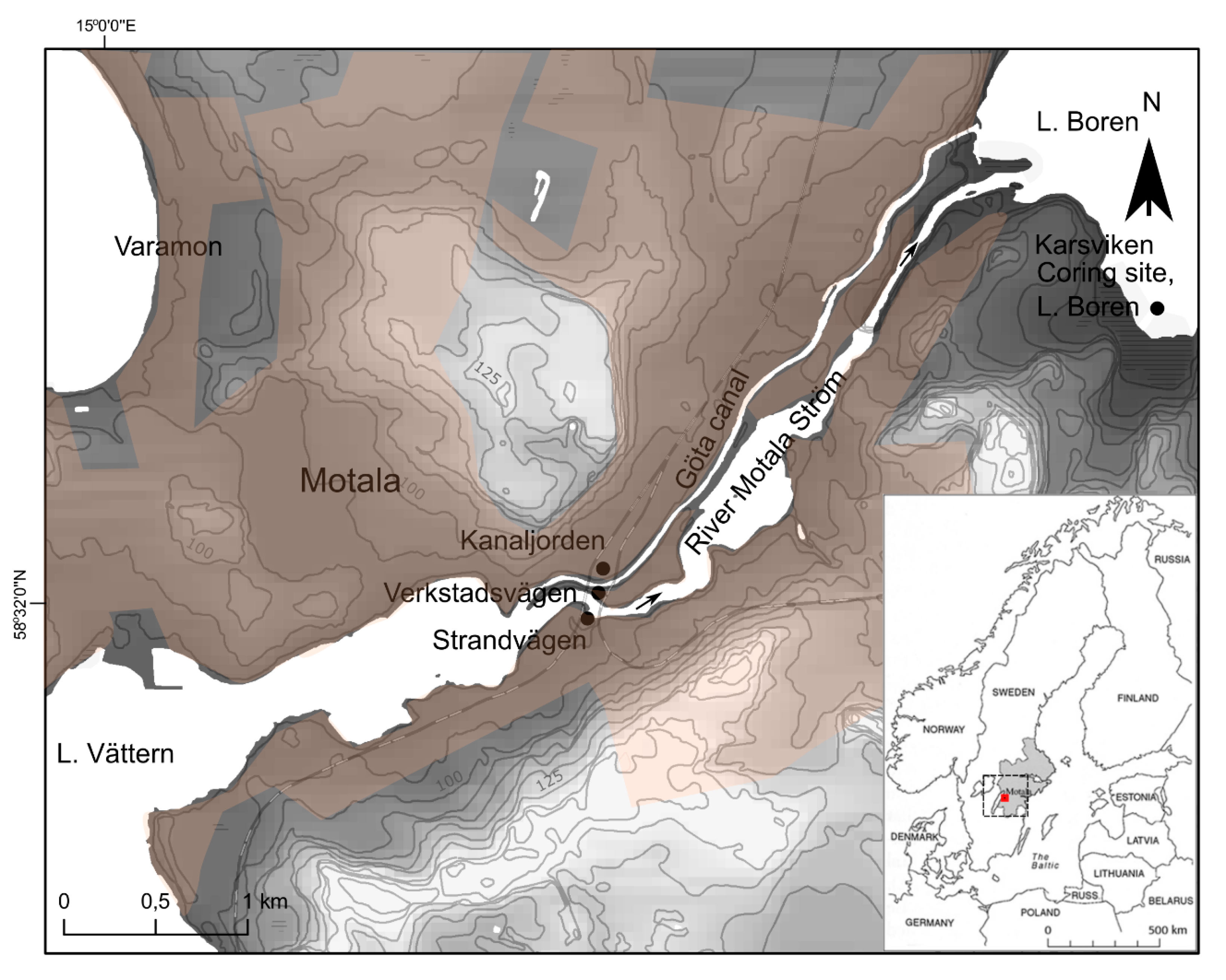
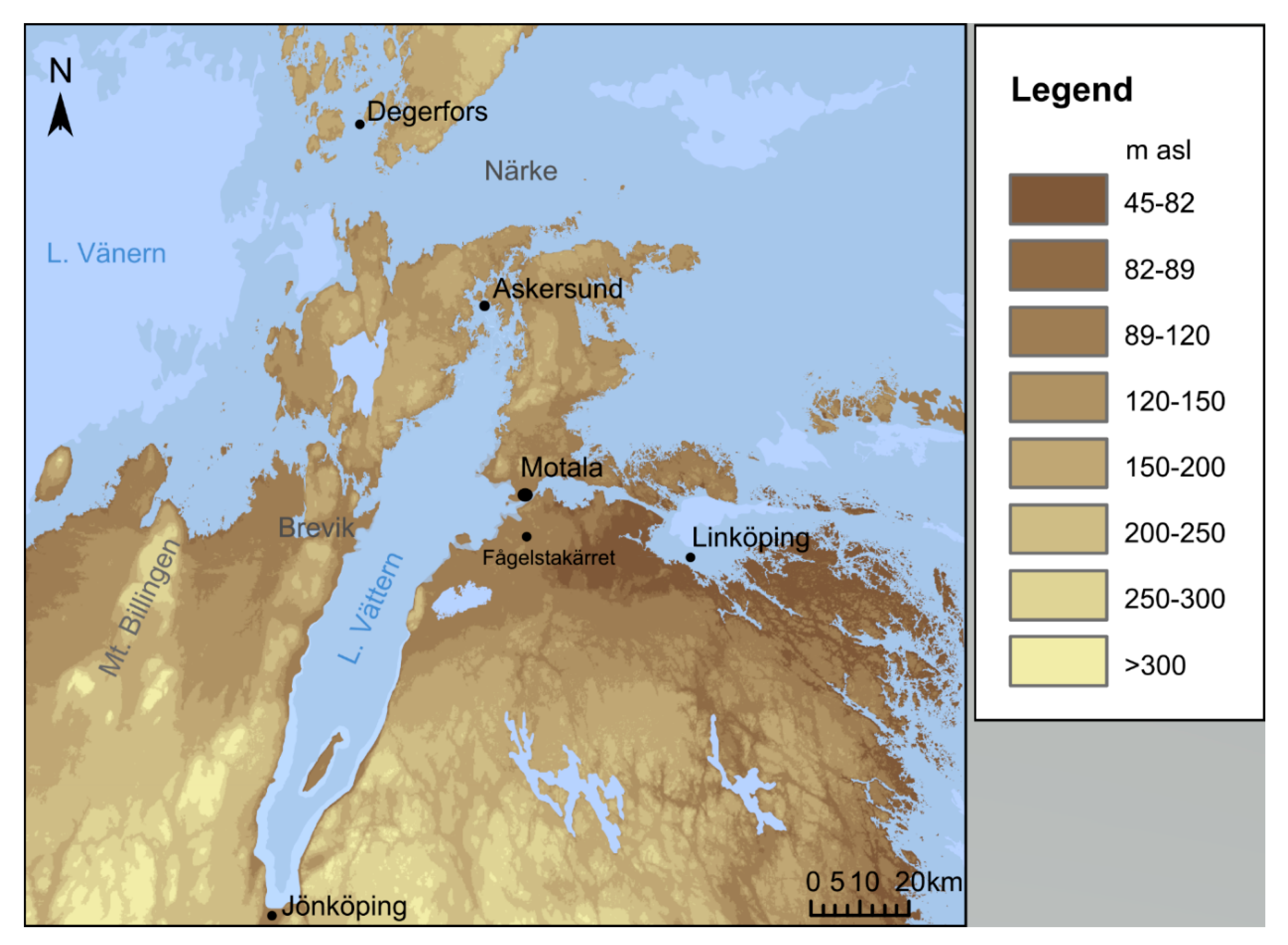
2. Site Description
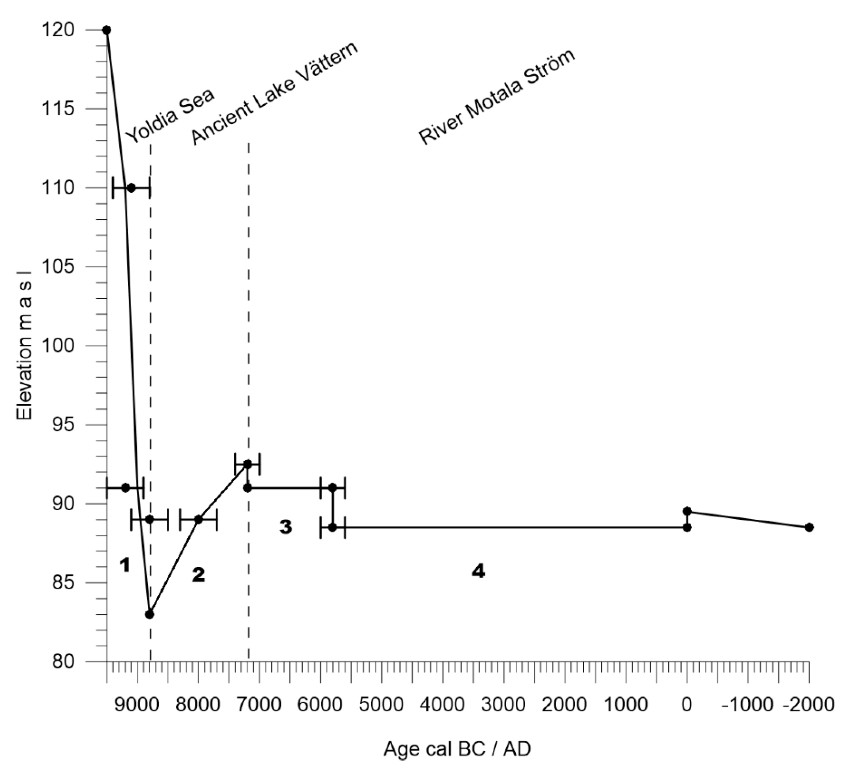
3. Shoreline History of the Vättern Area
- (1)
- The River Motala Ström did not form immediately after deglaciation.
- (2)
- There was a transgression in the Vättern basin during the early Holocene, resulting in the formation of River Motala Ström.
4. Methods
4.1. Macrofossil Analysis
4.2. Pollen Analysis
4.3. Lake Boren Sediment Coring
4.4. Diatom Analysis
5. Results and Interpretation
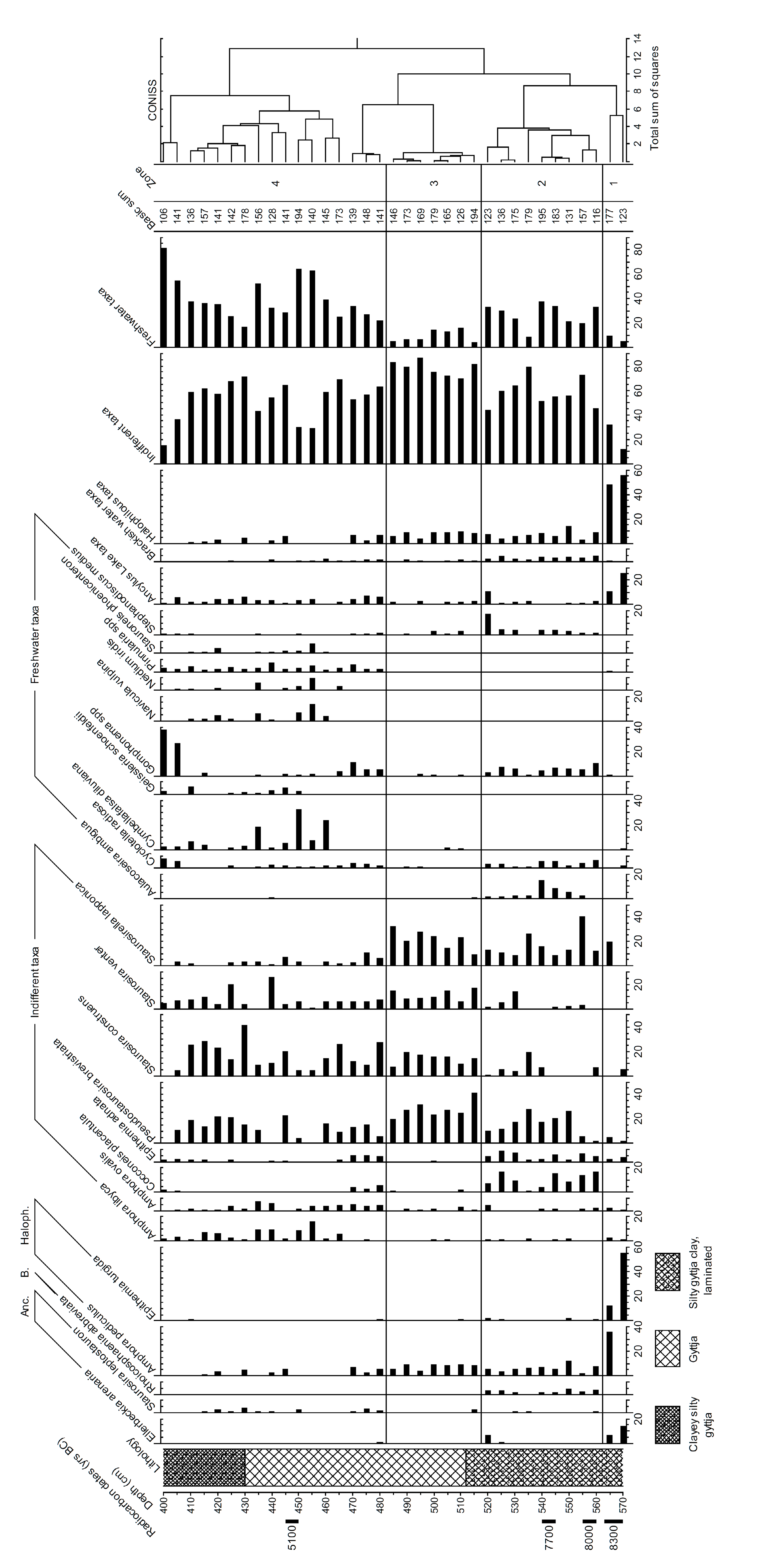
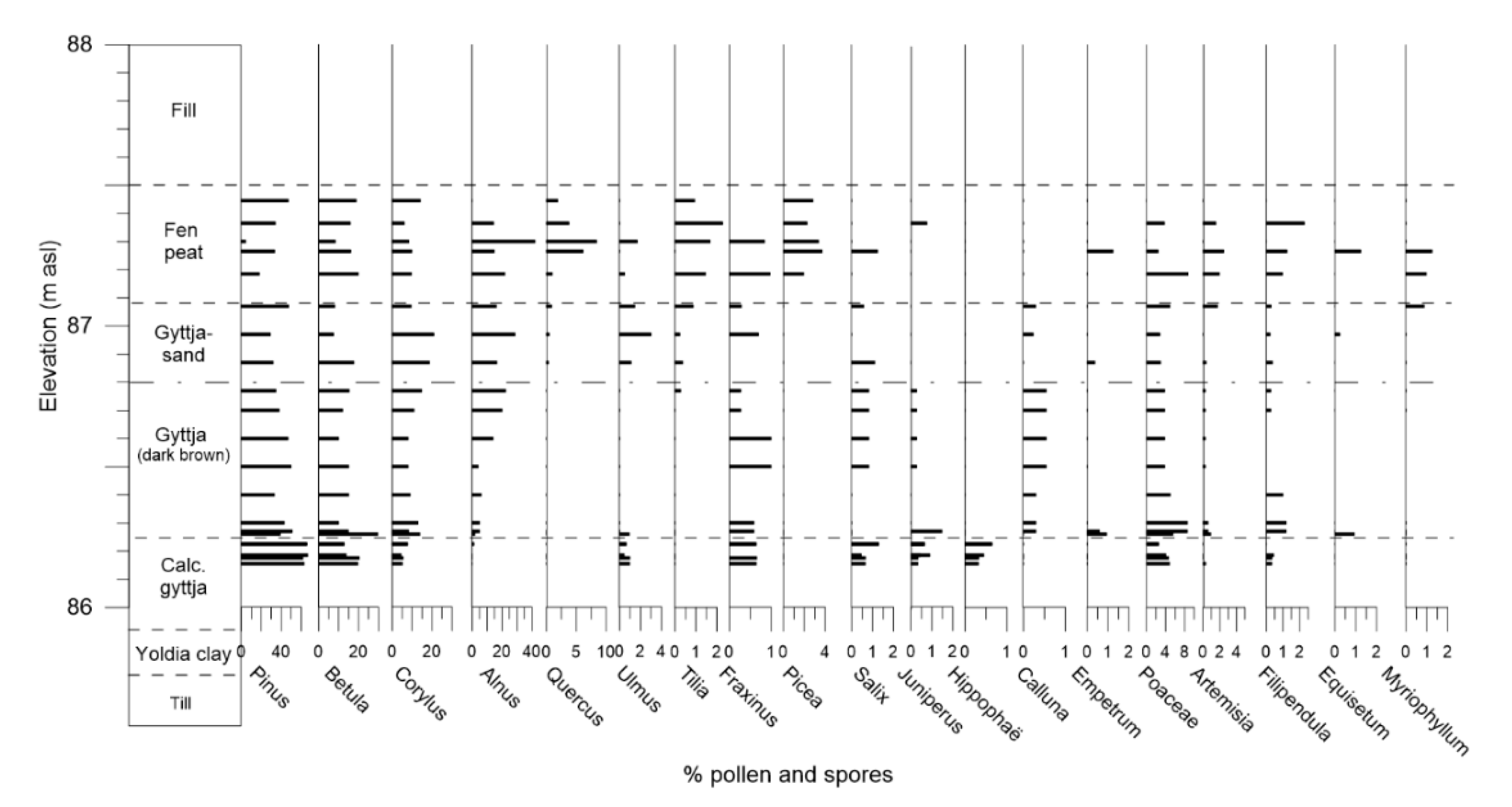
5.1. Lake Boren Sediment Records
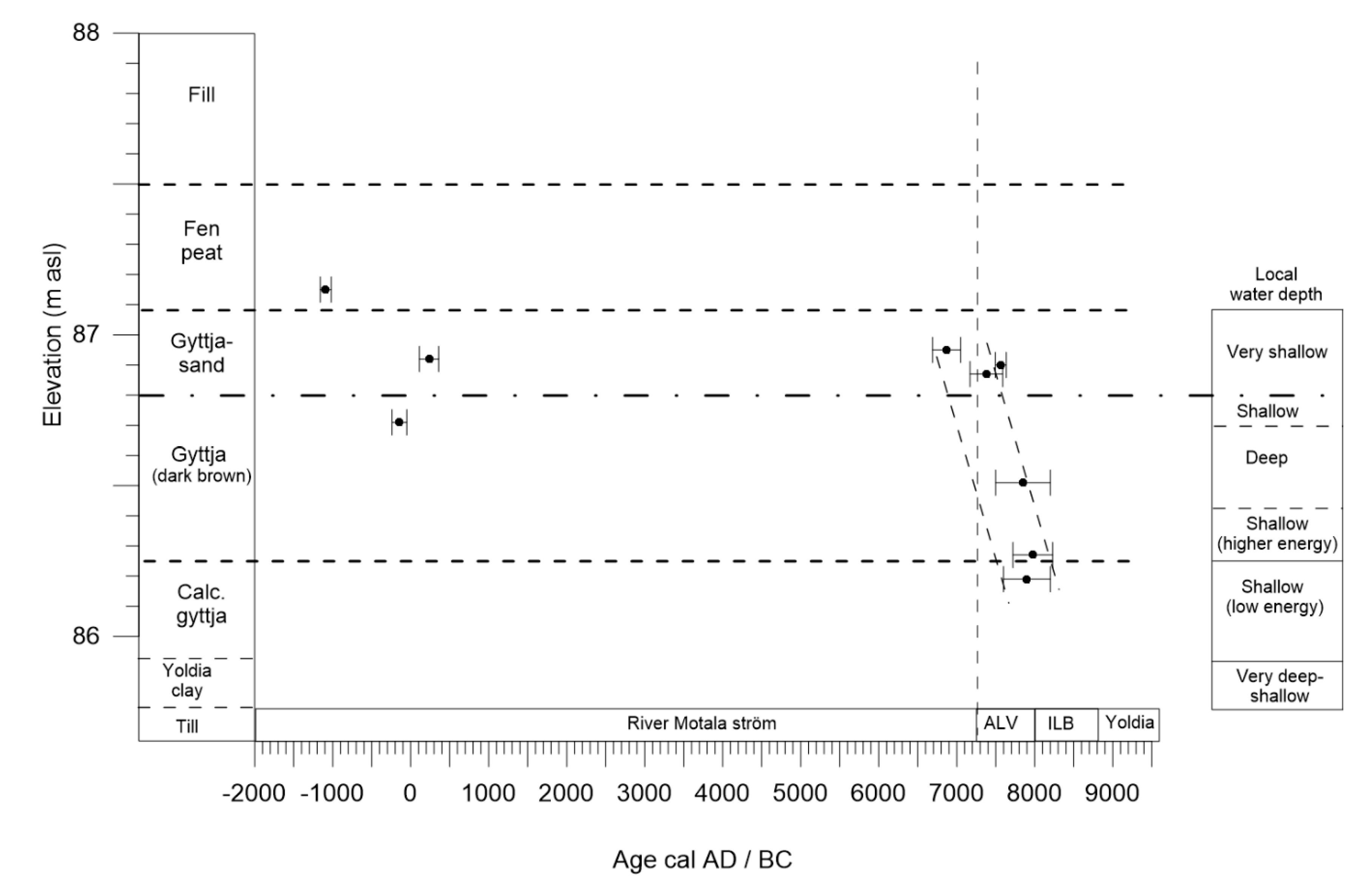
5.2. Strandvägen Sediment Records
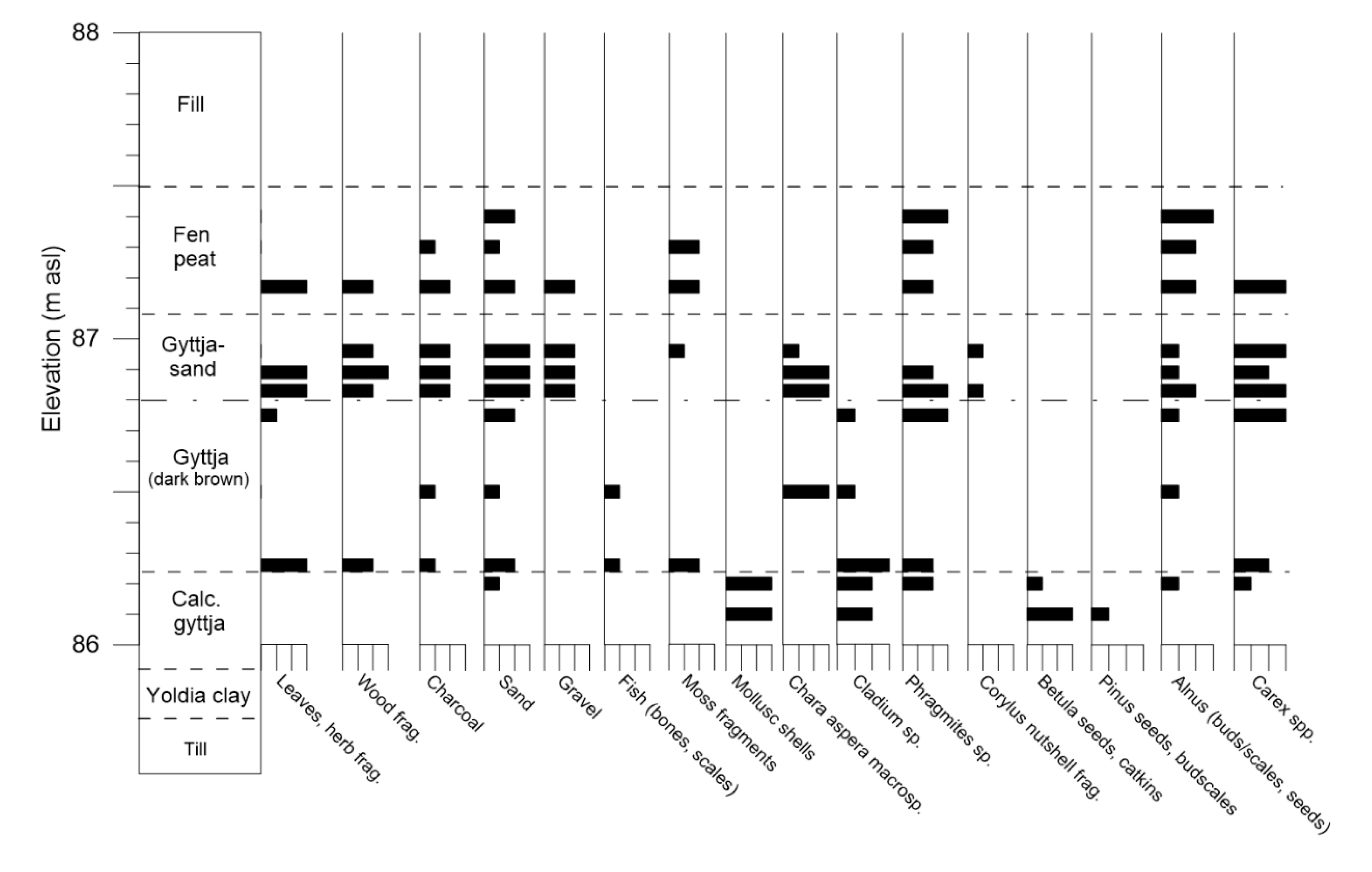
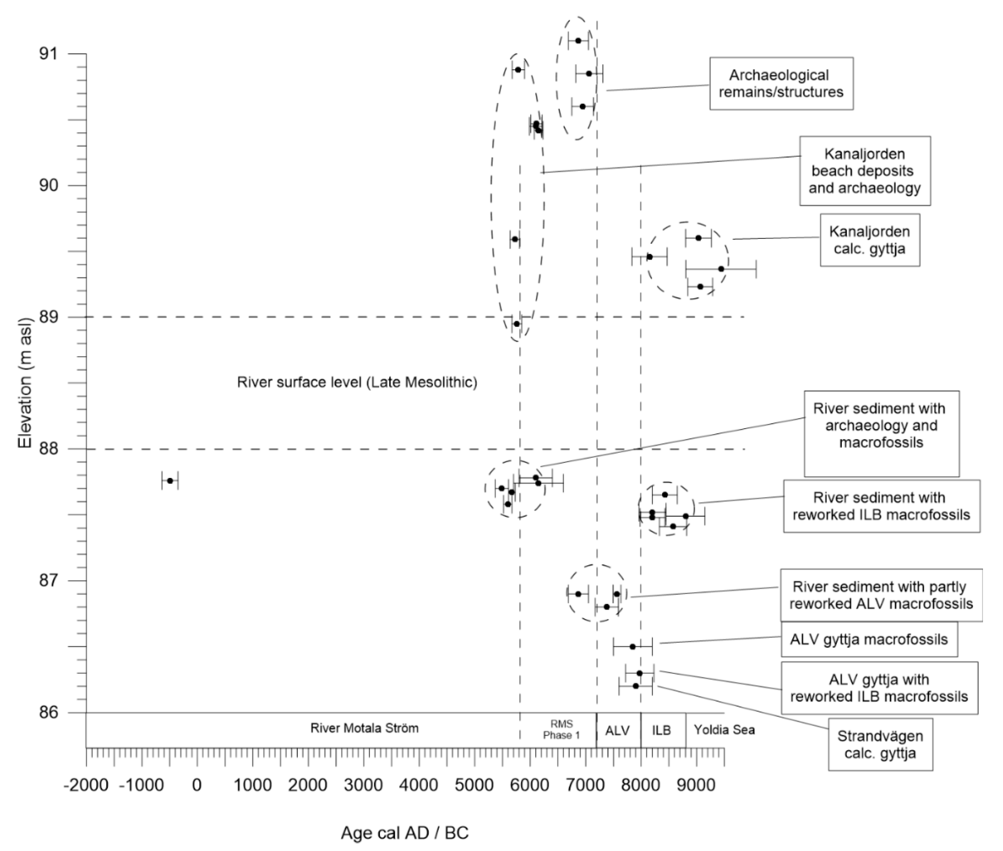
5.3. Kanaljorden Stratigraphy
6. Discussion
6.1. The Tilting of Lake Vättern and the Northern Outlet
6.2. The Ancylus Lake in the Vättern Basin?
6.3. Dating River Motala Ström and the River Formation Process
Author Contributions
Funding
Acknowledgments
Conflicts of Interest
References
- Lindén, M.; Möller, P.; Björck, S. Holocene shore displacement and deglaciation chronology in Norrbotten, Sweden. Boreas 2006, 35, 1–22. [Google Scholar] [CrossRef]
- Saarnisto, M. Late Holocene land uplift/neotectonics on the island of Valamo (Valaam), Lake Ladoga, NW Russia. Quat. Int. 2012, 260, 143–152. [Google Scholar] [CrossRef]
- Preusser, F.; May, J.-H.; Eschbach, D.; Trauerstein, M.; Schmitt, L. Infrared stimulated luminescence dating of 19th century fluvial deposits from the upper Rhine River. Geochronometria 2016, 43, 131–142. [Google Scholar] [CrossRef] [Green Version]
- Mulligan, R.P.M.; Eyles, C.H.; Bajc, A.F. Stratigraphic analysis of Late Wisconsin and Holocene glaciolacustrine deposits exposed along the Nottawasaga River, southern Ontario, Canada. Can. J. Earth Sci. 2018, 55, 863–885. [Google Scholar] [CrossRef]
- Johansson, H.G. Description to the Quaternary Map Linköping NV; Series Ae 24; Swedish Geological Survey: Stockholm: Sweden, 1976; p. 102. [Google Scholar]
- Molin, F.; Gruber, G.; Hagberg, L. Motala—A North European Focal Point? In Lateglacial and Postglacial Pioneers in Northern Europe; Riede, F., Tallavaara, M., Eds.; BAR International Series 2599; Archaeopress: Oxford, UK, 2014; pp. 91–102. [Google Scholar]
- Hagberg, L.; Westermark, A. Material culture and Mesolithic actions in space: Results of the spatial analysis of the Verkstadsvägen site in Motala. In Muge 150th: The 150th Anniversary of the Discovery of Mesolithic Shellmiddens–Volume 2; Bicho, N., Detry, C., Price, T.D., Cunha, E., Eds.; Cambridge Scholars Publishing: Newcastle Upon Tyne, UK, 2015; pp. 219–234. [Google Scholar]
- Gummesson, S.; Molin, F. The Mesolithic cemetery at Strandvägen, Motala, in eastern central Sweden. In Mesolithic Burials–Rites, Symbols and Social Organisation of Early Postglacial Communities, Proceedings of the International Conference, Halle (Saale), Germany, 18–21 September 2013; Tagungen des Landesmuseums für Vorgeschichte Halle (Saale); Grünberg, J.M., Gramsch, B., Larsson, L., Orschiedt, J., Meller, H., Eds.; Landesamt für Denkmalpflege und Archäologie Sachsen-Anhalt, Landesmuseum für Vorgeschichte: Halle (Saale), Germany, 2016; Volume 13, pp. 145–159. [Google Scholar]
- Molin, F.; Hagberg, H.; Westermark, A. Living by the Shore: Mesolithic Dwellings and Household in Motala, Eastern Central Sweden, 5000–5600 cal BC. J. Archaeol. Sci. Rep. 2018, 18, 913–924. [Google Scholar] [CrossRef]
- Bergman, J. Stone age disease in the north—Human intestinal parasites from a Mesolithic burial in Motala, Sweden. J. Archaeol. Sci. 2018, 96, 26–32. [Google Scholar] [CrossRef]
- Carlsson, T. Where the River Bends under the Boughs of Trees: Strandvägen—A Late Mesolithic Settlement in Eastern Middle Sweden; Riksantikvarieämbetet: Stockholm, Sweden, 2008. [Google Scholar]
- Hallgren, F.; Fornander, E. Skulls on stakes and skulls in water. Mesolithic mortuary rituals at Kanaljorden, Motala, Sweden 7000 BP. In Mesolithic Burials–Rites, Symbols and Social Organisation of Early Postglacial Communities, Proceedings of the International Conference Halle (Saale), Germany, 18–21 September 2013; Tagungen des Landesmuseums für Vorgeschichte Halle (Saale); Grünberg, J.M., Gramsch, B., Larsson, L., Orschiedt, J., Meller, H., Eds.; Landesamt für Denkmalpflege und Archäologie Sachsen-Anhalt, Landesmuseum für Vorgeschichte: Halle (Saale), Germany, 2016; Volume 13, pp. 161–174. [Google Scholar]
- Hallgren, F. A small Preboreal settlement site at Kanaljorden, Motala, Sweden. In The Ecology of Early Settlement in Northern Europe: Conditions for Subsistence and Survival; The Early Settlement of Northern Europe; Persson, P., Skar, B., Breivik, H.M., Eds.; Equinox Publishing Ltd.: Sheffield, UK, 2018; Volume 1, pp. 221–244. [Google Scholar]
- Björck, S.; Andrén, T.; Jensen, J.B. An Attempt to Resolve the Partly Conflicting Data and Ideas on the Ancylus-Littorina Transition. Pol. Geol. Inst. Spec. Pap. 2008, 23, 21–26. [Google Scholar]
- Björck, J.; Possnert, G.; Schoning, K. Early Holocene deglaciation chronology in Västergötland and Närke, southern Sweden—Biostratigraphy, clay varve, 14C and calendar year chronology. Quat. Sci. Rev. 2001, 20, 1309–1326. [Google Scholar] [CrossRef]
- Björck, S. The late Quaternary development of the Baltic Sea. In Assessment of Climate Change for the Baltic Sea Basin; The BACC Author Team, Ed.; Springer: Heidelberg, Germany, 2008; pp. 398–407. [Google Scholar]
- Andrén, T.; Björck, S.; Andrén, E.; Conley, D.; Zillén, L.; Anjar, J. The development of the Baltic Sea Basin during the Last 130 ka. In The Baltic Sea Basin; Harff, J., Björck, S., Hoth, P., Eds.; Springer: Heidelberg, Germany, 2011; pp. 75–98. [Google Scholar]
- Hansson, A.; Björck, S.; Heger, K.; Holmgren, S.; Linderson, H.; Magnell, O.; Nilsson, B.; Rundgren, M.; Sjöström, A.; Hammarlund, D. Shoreline displacement and human resource utilization in the southern Baltic Basin coastal zone during the early Holocene: New insights from a submerged Mesolithic landscape in south-eastern Sweden. Holocene 2017, 28, 721–737. [Google Scholar] [CrossRef]
- Karlsson, S.; Larsson, L.K. Vegetationshistoria i Fågelstaområdet, västra Östergötland. Fågelstaprojektet. Fem arkeologiska undersökningar i västra Östergötlands slättbygd. UV Öst Rep. 2008, 29, 1–22. [Google Scholar]
- Plikk, A.; Risberg, J. Kvartärgeologiska undersökningar i Skänninge och Västra Stenby socken, Östergötland. In 10 000 år vid Södra Freberga; Carlsson, T., Ed.; 2012; in press. [Google Scholar]
- Hansson, A.; Boethius, A.; Hammarlund, D.; Lagerås, P.; Magnell, O.; Nilsson, B.; Brunlid, A.N.; Rundgren, M. Shorline displacement, coastal environments and human subsistence in the Hanö Bay Region during the Mesoltihic. Quaternaria 2019, 2, 14. [Google Scholar] [CrossRef] [Green Version]
- Nilsson, E. The Late-quaternary history of southern Sweden. Geochronology, ice-lakes, land-uplift. K. Sven. Vetensk. Handl. Fjärde Ser. 1968, 12, 1–117. [Google Scholar]
- Fromm, E. Description to the Quaternary map Linköping NO; Series Ae 19; Swedish Geological Survey: Stockholm, Sweden, 1976; p. 77. [Google Scholar]
- Björck, S. A review of the history of the Baltic Sea, 13.0–8.0 ka BP. Quat. Int. 1995, 27, 19–40. [Google Scholar] [CrossRef]
- Björck, S.; Svensson, N.O. Östersjöns och Västerhavets utveckling. In Berg Och Jord; Fredén, C., Ed.; Sveriges Nationalatlas: Vällingby, Sweden, 2002; pp. 138–142. [Google Scholar]
- Andrén, E.; Andrén, T.; Sohlenius, G. The Holocene history of the southwestern Baltic Sea as reflected in a sediment core from the Bornholm Basin. Boreas 2000, 29, 233–250. [Google Scholar] [CrossRef]
- Munthe, H. Till frågan om Vätterns senkvartära historia. Geol. Föreningens Stockh. Förhandlingar 2018, 57, 29–46. [Google Scholar] [CrossRef]
- Nilsson, E. Bidrag till Vätterns och Bolmens senkvartära historia. Geol. Föreningens Stockh. Förhandlingar 1937, 59, 189–204. [Google Scholar] [CrossRef]
- Nilsson, E. Södra Sveriges senkvartära historia. Geol. Föreningens Stockh. Förhandlingar 1953, 75, 155–246. [Google Scholar] [CrossRef]
- Norrman, J.O. Vätterbäckenets senkvartära strandlinjer. Geol. Föreningens Stockh. Förhandlingar 1964, 85, 391–413. [Google Scholar] [CrossRef]
- Granlund, E. Vättern och landhöjningen—Mäster Gudmund Gilles Årsbok; Mäster Gudmunds Gille: Jönköping, Sweden, 1933; pp. 11–35. [Google Scholar]
- Svantesson, S.-I. Beskrivning till jordartskartan Jönköping SV. Sver. Geol. Undersökning 1985, 59, 1–171. [Google Scholar]
- Swärd, H.; O’Regan, M.; Björck, S.; Greenwood, S.L.; Kylander, M.E.; Mörth, C.-M.; Pearce, C.; Jakobsson, M. A chronology of environmental changes in the Lake Vättern basin from deglaciation to final isolation. Boreas 2018, 47, 609–624. [Google Scholar] [CrossRef]
- Bergman, J.; Heimdahl, J.; Hagberg, L. Kvartärgeologi och paleoekologi vid Strandvägen. In Strandvägen—Mesolitisk Boplats och Gravfält i Motala; Molin, F., Hagberg, L., Westermark, A., Zetterlund, P., Eds.; Arkeologerna: Stockholm, Sweden, 2021; in press. [Google Scholar]
- Plikk, A.; Regnell, M.; Risberg, J. Miljöförändringar i södra Motala stad, 1000–1,010,000 BC. In Kanaljorden, Motala—Rituella Våtmarksdepositioner och Boplatslämningar Från Stenåldern; Hallgren, F., Ed.; Stiftelsen Kulturmiljövård: Västerås, Sweden, 2021; in press. [Google Scholar]
- Wasylikowa, K. Analysis of fossil fruits and seeds. In Handbook of Holocene Palaeoecology and Palaeohydrology; Berglund, B.E., Ed.; John Wiley & Sons Ltd.: Chichester, UK, 1986; pp. 571–590. [Google Scholar]
- Berggren, G. Atlas of Seeds. Part 2. Cyperaceae; Swedish Natural Science Research Council: Stockholm, Sweden, 1969. [Google Scholar]
- Berggren, G. Atlas of Seeds. Part 3. Salicaceae Cruciferae; Swedish Natural Science Research Council: Stockholm, Sweden, 1981. [Google Scholar]
- Anderberg, A.-L. Atlas of Seeds. Part 4. Resedaceae-Umbelliferae; Naturhistoriska Riksmuseet: Stockholm, Sweden, 1994. [Google Scholar]
- Cappers, R.T.T.; Neef, R.; Bekker, R.-M. Digital Atlas of Economic Plants; Groningen Archaeological Studies vol 9; Barkhuis: Groningen, The Netherlands, 2009. [Google Scholar]
- Berglund, B.E.; Ralska-Jasiewiczowa, M. Pollen analysis and pollen diagrams. In Handbook of Holocene Palaeoecology and Palaeohydrology; Berglund, B.E., Ed.; Wiley: Chichester, UK, 1986; pp. 455–484. [Google Scholar]
- Beug, H.-J. Leitfaden der Pollenbestimmung fûr Mitteleuropa und Angrenzende Gebiete; Verlag Dr. Friedrich Pfeil: Mûnchen, Germany, 2004; p. 542. [Google Scholar]
- Bronk Ramsey, C. Bayesian Analysis of Radiocarbon Dates. Radiocarbon 2009, 51, 337–360. [Google Scholar] [CrossRef] [Green Version]
- Reimer, P.J.; Bard, E.; Bayliss, A.; Beck, J.W.; Blackwell, P.G.; Ramsey, C.B.; Buck, C.E.; Cheng, H.; Edwards, R.L.; Friedrich, M.; et al. Intcal13 and Marine13 Radiocarbon Age Calibration Curves 0–50,000 Years Cal BP. Radiocarbon 2013, 55, 1869–1887. [Google Scholar] [CrossRef] [Green Version]
- Battarbee, R.W. Diatom analysis. In Handbook of Holocene Palaeoecology and Palaeohydrology; Berglund, B.E., Ed.; John Wiley & Sons: Chichester, UK, 1986; pp. 527–570. [Google Scholar]
- Krammer, K.; Lange-Bertalot, H. Bacillariophyceae. 1.Teil: Naviculaceae. In Süsswasserflora von Mitteleuropa, 2/1; Gustav Fischer Verlag: Stuttgart, Germany, 1986; 876p. [Google Scholar]
- Krammer, K.; Lange-Bertalot, H. Bacillariophyceae. 2.Teil: Bacillariaceae, Epithemiaceae, Surirellaceae. In Süsswasserflora von Mitteleuropa, 2/2; Gustav Fischer Verlag: Stuttgart, Germany, 1988; 596p. [Google Scholar]
- Krammer, K.; Lange-Bertalot, H. Bacillariophyceae. 3.Teil: Centrales, Fragilariaceae, Eunotiaceae. In Süsswasserflora von Mitteleuropa, 2/3; Gustav Fischer Verlag: Stuttgart, Germany, 1991; 576p. [Google Scholar]
- Krammer, K.; Lange-Bertalot, H. Bacillariophyceae. 4.Teil: Achnanthaceae. Kritische Ergänzungen zur Navicula (Lineolate) und Gomphonema. In Süsswasserflora von Mitteleuropa, 2/4; Gustav Fischer Verlag: Stuttgart, Germany, 1991; 437p. [Google Scholar]
- Eronen, M. The history of the Litorina Sea and associated Holocene events. Comment. Phys. Math. Soc. Sci. Fenn. 1974, 44, 79–195. [Google Scholar]
- Risberg, J. Palaeoenvironment and Sea Level Changes during the Early Holocene on the Södertörn Peninsula, Södermanland, Eastern Sweden. Ph.D. Thesis, Stockholm University, Stockholm, Sweden, 1991; 27p. [Google Scholar]
- Hedenström, A.; Risberg, J. Early Holocene shore-displacement in southern central Sweden as recorded in elevated isolated basins. Boreas 1999, 28, 490–504. [Google Scholar] [CrossRef]
- Bergström, S.M.; Calner, M.; Lehnert, O.; Noor, A. A new upper Middle Ordovician–Lower Silurian drillcore standard succession from Borenshult in Östergötland, southern Sweden: 1. Stratigraphical review with regional comparisons. GFF 2011, 133, 149–171. [Google Scholar] [CrossRef]
- Bona, F.; Falasco, E.; Fassina, S.; Griselli, B.; Badino, G. Characterization of diatom assemblages in mid-altitude streams of NW Italy. Hydrobiologia 2007, 583, 265–274. [Google Scholar] [CrossRef]
- King, L.; Clarke, G.; Bennion, H.; Kelly, M.; Yallop, M. Recommendations for sampling littoral diatoms in lakes for ecological status assessments. Environ. Boil. Fishes 2006, 18, 15–25. [Google Scholar] [CrossRef]
- Hargan, K.E.; Rühland, K.M.; Paterson, A.M.; Finkelstein, S.A.; Holmquist, J.R.; Macdonald, G.M.; Keller, B.W.; Smol, J.P. The influence of water-table depth and pH on the spatial distribution of diatom species in peatlands of the Boreal Shield and Hudson Plains, Canada. Botany 2015, 93, 57–74. [Google Scholar] [CrossRef]
- Krause, W. Charales (Charophyceae). In Süsswasserflora von Mitteleuropa, 18; Gustav Fischer Verlag: Jena, Germany, 1997; 202p. [Google Scholar]
- Molin, F.; Hagberg, L.; Westermark, A.; Zetterlund, P. Strandvägen—Mesolitisk Boplats och Gravfält i Motala; Arkeologerna, Rapport; Statens Historiska Museer: Stockholm, Sweden, 2021; in press. [Google Scholar]
- Hallgren, F. Kanaljorden, Motala—Rituella Våtmarksdepositioner och Boplatslämningar Från Stenåldern; Stiftelsen Kulturmiljövård: Västerås, Sweden, 2021; in press. [Google Scholar]
- Divišová, M.; Šída, P. Plant Use in the Mesolithic Period. Archaeobotanical Data from the Czech Republic in a European Context—A Review. Interdiscip. Archaeol. Nat. Sci. Archaeol. 2015, 6, 95–106. [Google Scholar] [CrossRef]
- Regnell, M. Archaeobotanical Finds from the Stone Age of the Nordic Countries: A Catalogue of Plant Remains from Archaeological Contexts; Lundqua Report 36; Lund University, Department of Quaternary Geology: Lund, Sweden, 1998; 27p. [Google Scholar]
- Göransson, H. Alvastra Pile Dwelling: Palaeoethnobotanical Studies; Lund University Press: Lund, Sweden, 1995. [Google Scholar]
- Björck, S.; Dennegård, B.; Sandgren, P. The marine stratigraphy of the Hanö Bay, SE Sweden, based on different sediment stratigraphic methods. Geol. Föreningens Stockh. Förhandlingar 1990, 112, 265–280. [Google Scholar] [CrossRef]
- Karlsson, S.; Risberg, J. Holocen Miljöhistoria i Centrala Närke. UV Rep. 1997, 38, 1–84. [Google Scholar]
- Gummesson, S.; Hallgren, F.; Kjellström, A. Keep your head high: Skulls on stakes and cranial trauma in Mesolithic Sweden. Antiquity 2018, 92, 74–90. [Google Scholar] [CrossRef]
- Cohen, K.M.; Harper, D.A.T.; Gibbard, P.L. 2020 ICS International Chronostratigraphic Chart 2020/03; International Commission on Stratigraphy, IUGS. Available online: www.stratigraphy.org (accessed on 3 May 2020).
- Holmes, J.A.; Tindall, J.; Roberts, N.; Marshall, W.; Marshall, J.D.; Bingham, A.; Feeser, I.; O’Connell, M.; Atkinson, T.; Jourdan, A.-L.; et al. Lake isotope records of the 8200-year cooling event in western Ireland: Comparison with model simulations. Quat. Sci. Rev. 2016, 131, 341–349. [Google Scholar] [CrossRef] [Green Version]
- Bergman, J.; Hammarlund, D.; Hannon, G.; Barnekow, L.; Wohlfarth, B. Deglacial vegetation succession and Holocene tree-limit dynamics in the Scandes Mountains, west-central Sweden: Stratigraphic data compared to megafossil evidence. Rev. Palaeobot. Palynol. 2005, 134, 129–151. [Google Scholar] [CrossRef]


| Depth (cm) | Lab. Nr | δ13C VPDB | 14C age BP | Age cal BC (2σ) |
|---|---|---|---|---|
| 447.5 | Ua-51176 | −29.3 | 6156 ± 38 | 5215–5002 |
| 542.5 | Ua-51177 | −26.5 | 8708 ± 43 | 7936–7597 |
| 557.5 | Ua-51178 | −25.5 | 8847 ± 46 | 8213–7787 |
| 566.5 | Ua-51179 | −27.0 | 9137 ± 33 | 8451–8279 |
| Site | Locality | Section, Archaeological Context | Sediment Layer | m a.s.l. | Sample No | Dated Material | C14-Age BP | Age cal a BC (2σ) |
|---|---|---|---|---|---|---|---|---|
| Strandvägen | Cemetery | Mesolithic burial 02 | Sandy filling | 91.1 | Ua-30873 | Charred Corylus | 7963 ± 45 | 7050–6690 |
| Mesolithic burial 10 | Sandy filling | 90.85 | Ua-31398 | Querqus charcoal | 8099 ± 53 | 7310–6820 | ||
| Mesolithic burial 09 | Sandy filling | 90.32 | Ua-31397 | Pinus charcoal | 8035 ± 52 | 7140–6750 | ||
| Backwater | C 5257 | River sediment (gyttja/sand) | 87.78 | Ua-31810 | Nutshell Corylus | 7187 ± 122 | 6400–5800 | |
| Western part of backwater | C 4248 | River sediment (gyttja/sand) | 87.76 | Ua-29700 | Seeds (Betula) | 1566 ± 65 | −350–−640 | |
| C 4248 | River sediment (gyttja/sand) | 87.74 | Ua-31811 | Nutshell Corylus | 7301 ± 217 | 6600–5700 | ||
| C 4248 | River sediment (gyttja/sand) | 87.7 | Ua-31812 | Nutshell Corylus | 6522 ± 51 | 5610–5370 | ||
| C 4248 | River sediment (gyttja/sand) | 87.67 | Ua-29701 | Nutshell Corylus | 6749 ± 38 | 5730–5610 | ||
| C 4248 | River sediment (gyttja/sand) | 87.65 | Ua-29702 | Seeds (Betula, Pinus, Scirpus/Carex) | 9119 ± 85 | 8650–8200 | ||
| C 4248 | River sediment (gyttja/sand) | 87.58 | Ua-31813 | Nutshell Corylus | 6684 ± 40 | 5670–5520 | ||
| C 4248 | River sediment (gyttja/sand) | 87.52 | Ua-31622 | Seeds (fen plants) | 9038 ± 75 | 8450–7960 | ||
| C 4248 | River sediment (gyttja/sand) | 87.49 | Ua-31621 | Seeds (fen plants) | 9419 ± 72 | 9150–8450 | ||
| C 4248 | River sediment (sandy gyttja) | 87.48 | Ua-31249 | Wood (Pinus) | 9045 ± 58 | 8430–7980 | ||
| C 4248 | River sediment (sandy gyttja) | 87.41 | Ua-29984 | Seed (Menyant-hes) | 9356 ± 78 | 8820–8330 | ||
| Eastern part of backwater | C 13059 | River sediment (gyttja/sand) | 86.9 | Ua-54534 | Wood (Pinus) | 8532 ± 38 | 7600–7530 | |
| C 13059 | River sediment (gyttja/sand) | 86.9 | Ua-31815 | Wood (Pinus) | 7961 ± 46 | 7050–6690 | ||
| C 13059 | River sediment | 86.8 | Ua-31816 | Wood (Salix) | 8354 ± 95 | 7590–7170 | ||
| C 13059 | Dark brown gyttja | 86.5 | Ua-31818 | Wood (Salix) | 8673 ± 100 | 8200–7500 | ||
| C 13059 | Dark brown gyttja | 86.3 | Ua-31819 | Seeds (Scirpus/Carex) | 8834 ± 66 | 8230–7720 | ||
| C 243837 | Calcareous gyttja | 86.2 | Ua-31820 | Seeds (Scirpus/Carex) | 8783 ± 48 | 8200–7600 | ||
| Kanaljorden | Southern basin | Log 3 | Peaty gyttja | 89.59 | Ua-41617 | Seeds (Betula), charcoal | 6836 ± 43 | 5808–5638 |
| Log 3 | Cobelly gravelly sand | 89.46 | Ua-41616 | Seeds, catkin-bracts (Betula) | 9016 ± 95 | 8468–7835 | ||
| Log 3 | Calcareous gyttja | 89.36 | Ua-41615 | Budscale, seed, bud (Betula) | 9876 ± 186 | 10072–8806 | ||
| Log 3 | Calcareous gyttja | 89.23 | Ua-41614 | Seeds (Scirpus/Carex) | 9699 ± 62 | 9288–8840 | ||
| P2861 | Sandy gyttja | 89.56 | Ua-39277 | Charcoal | 8201 ± 43 | 7340–7070 | ||
| P2861 | Sandy gyttja | 89.46 | Ua-41616 | Seeds (Betula) | 9016 ± 95 | 8468–7935 | ||
| P2861 | Cobelly gravelly sand | 90.88 | Ua-51087 | Charcoal, seeds (Corylus) | 6903 ± 51 | 5899–5674 | ||
| P2861 | Cobelly gravelly sand | 90.47 | Ua-51085 | Charcoal, seeds (Alnus) | 7223 ± 51 | 6215–6011 | ||
| P2861 | Cobelly gravelly sand | 90.45 | Ua-51086 | Charcoal, seeds (Alnus) | 7192 ± 50 | 6210–5987 | ||
| P2861 | Cobelly gravelly sand | 90.42 | Ua-54350 | Nutshell Corylus | 7302 ± 37 | 6231–6074 | ||
| wooden fish trap F362 in L187 | Shell/Calcar-eous gyttja | 88.95 | Ua-41897 | Salix twigs | 6878 ± 40 | 5846–5670 | ||
| Northern basin | Log 5 | Peat below calcareous gyttja | 89.6 | Ua-41951 | Catkin-bracts, seeds (Betula) | 9652 ± 82 | 9265–8801 |
| Lithology Log 3 | m a.s.l. | 14C-Samples (m a.s.l.) | Interpreted Environment | |
|---|---|---|---|---|
| Peat | >89.62 | Fen/bog | ||
| Peaty gyttja | 89.56–89.62 | 89.58–89.60 | Fen | |
| Sandy gyttja | Sandy peaty gyttja | 89.50–89.56 | Beach deposit | |
| Gravelly sandy gyttja (w. cobbles) | 89.44–89.50 | 89.45–89.47 | ALV transgression layer (erosional) | |
| Calcareous gyttja | 89.18–89.44 | 89.355–89.375 | Isolated lake basin (ILB) | |
| 89.22–89.24 | ||||
| Blue-grey clay | 89.14–89.18 | Yoldia Sea clay | ||
| Boulders | 89.08–89.14 | Glacial till |
© 2020 by the authors. Licensee MDPI, Basel, Switzerland. This article is an open access article distributed under the terms and conditions of the Creative Commons Attribution (CC BY) license (http://creativecommons.org/licenses/by/4.0/).
Share and Cite
Bergman, J.; Plikk, A.; Heimdahl, J.; Hagberg, L.; Hallgren, F.; Risberg, J.; Molin, F. When the River Began—The Formation of River Motala Ström and Human Presence in the Early Holocene, Sweden. Quaternary 2020, 3, 25. https://0-doi-org.brum.beds.ac.uk/10.3390/quat3030025
Bergman J, Plikk A, Heimdahl J, Hagberg L, Hallgren F, Risberg J, Molin F. When the River Began—The Formation of River Motala Ström and Human Presence in the Early Holocene, Sweden. Quaternary. 2020; 3(3):25. https://0-doi-org.brum.beds.ac.uk/10.3390/quat3030025
Chicago/Turabian StyleBergman, Jonas, Anna Plikk, Jens Heimdahl, Linus Hagberg, Fredrik Hallgren, Jan Risberg, and Fredrik Molin. 2020. "When the River Began—The Formation of River Motala Ström and Human Presence in the Early Holocene, Sweden" Quaternary 3, no. 3: 25. https://0-doi-org.brum.beds.ac.uk/10.3390/quat3030025