Remote Sensing Applied to the Study of Fire Regime Attributes and Their Influence on Post-Fire Greenness Recovery in Pine Ecosystems

 ,
,  , ,
, ,  and
and
Abstract
:
1. Introduction
2. Material and Methods
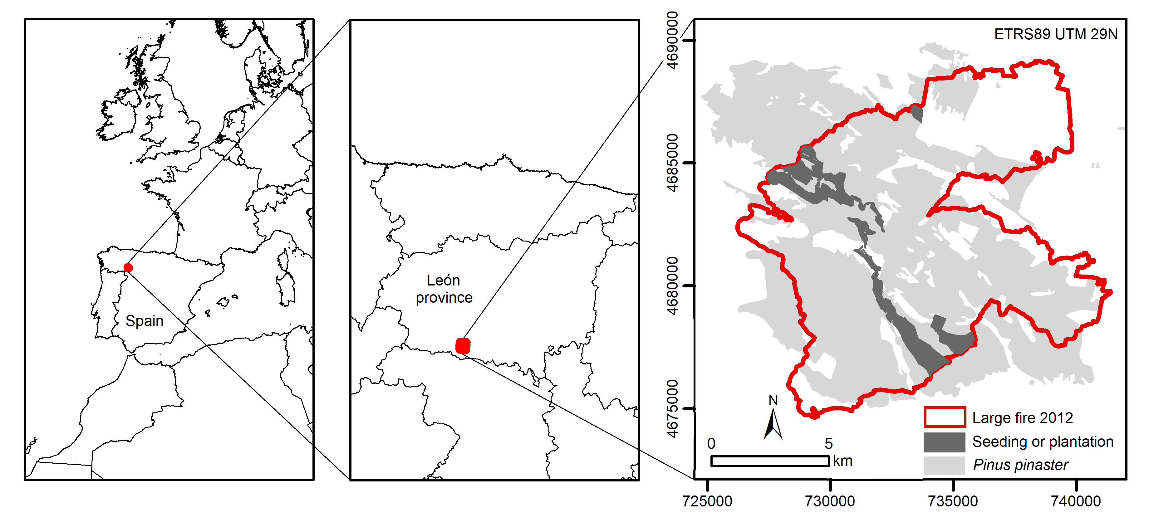
2.1. Study Area
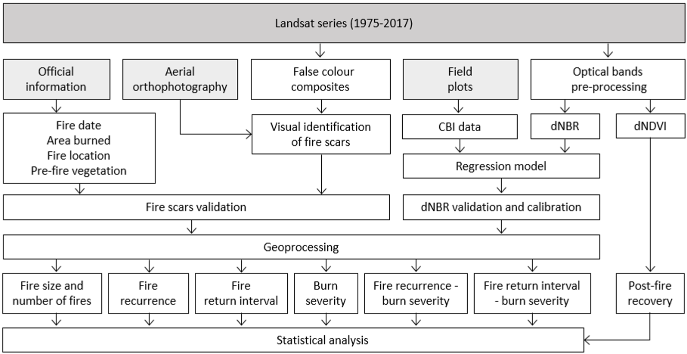
2.2. Methodology
2.2.1. Landsat Database
2.2.2. Fire Regime Characterization
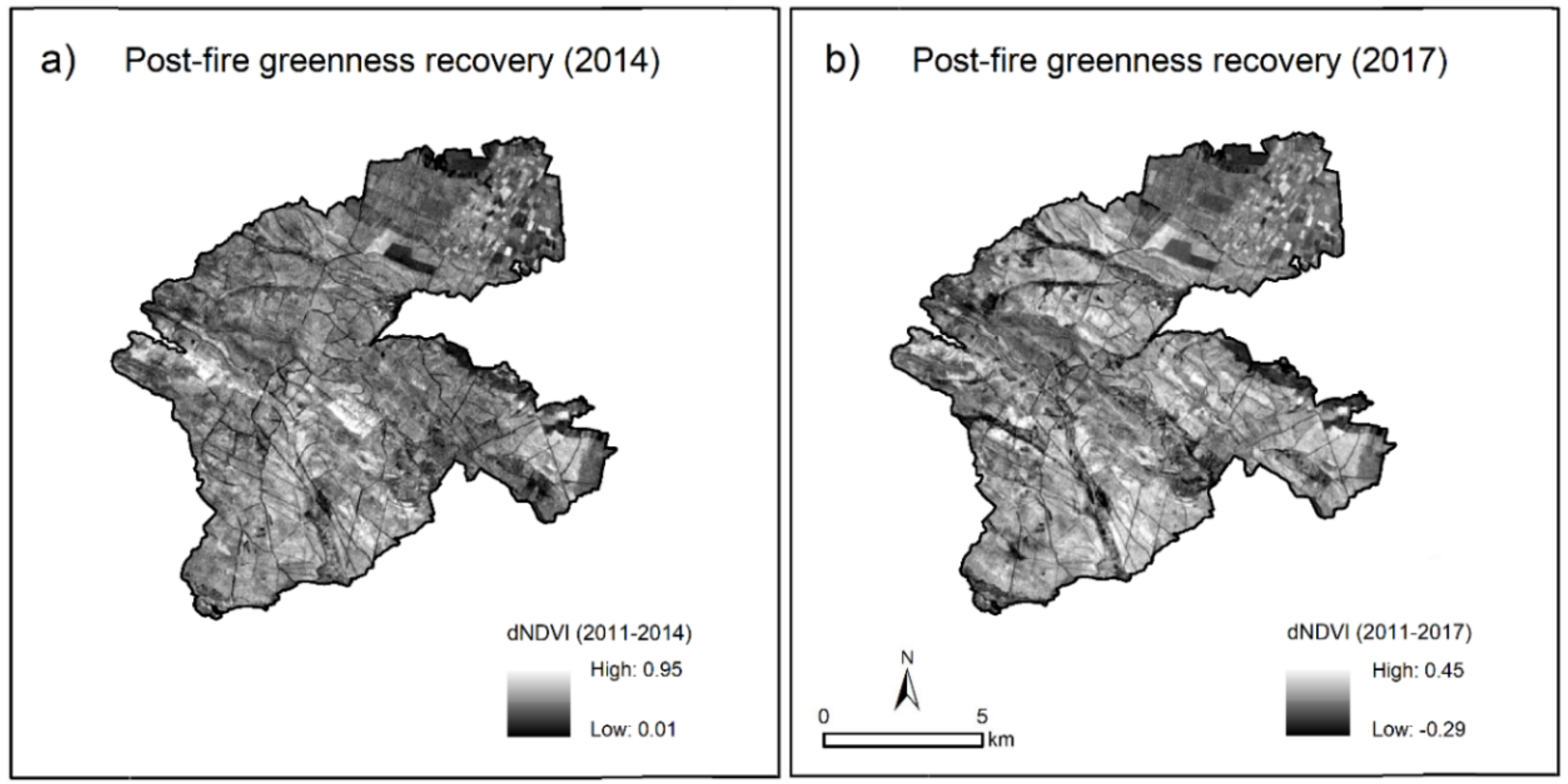
2.2.3. Post-Fire Greenness Characterization
2.2.4. Sampling
2.3. Data Analysis
3. Results
3.1. Fire Regime Attributes
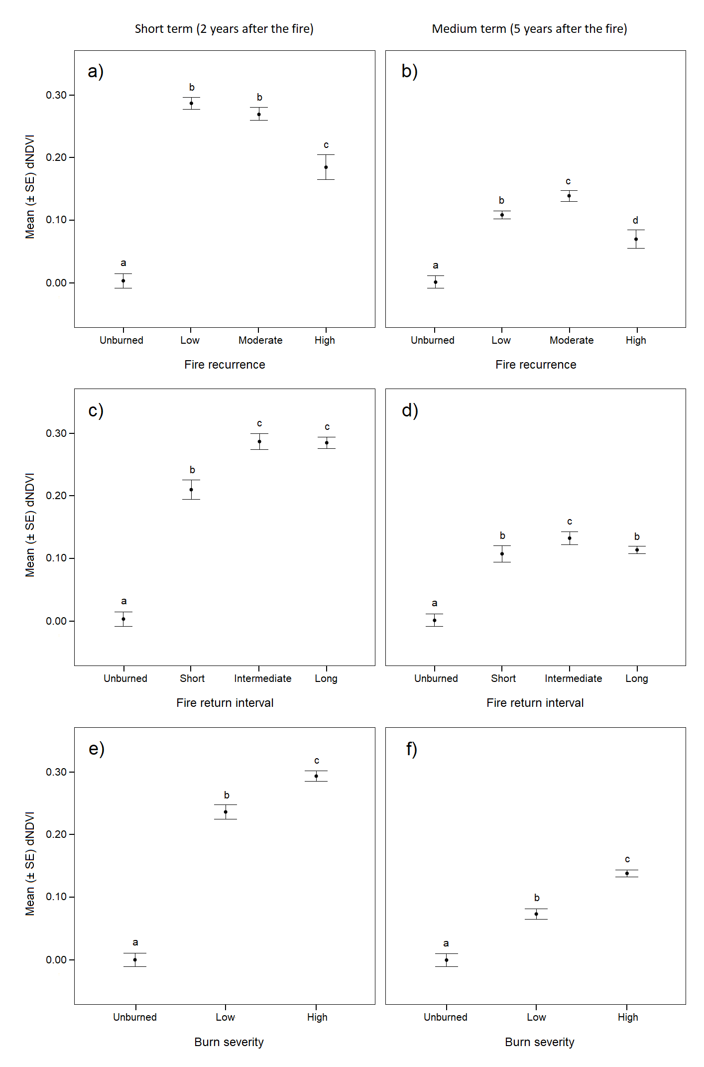
3.2. Post-Fire Greenness Recovery
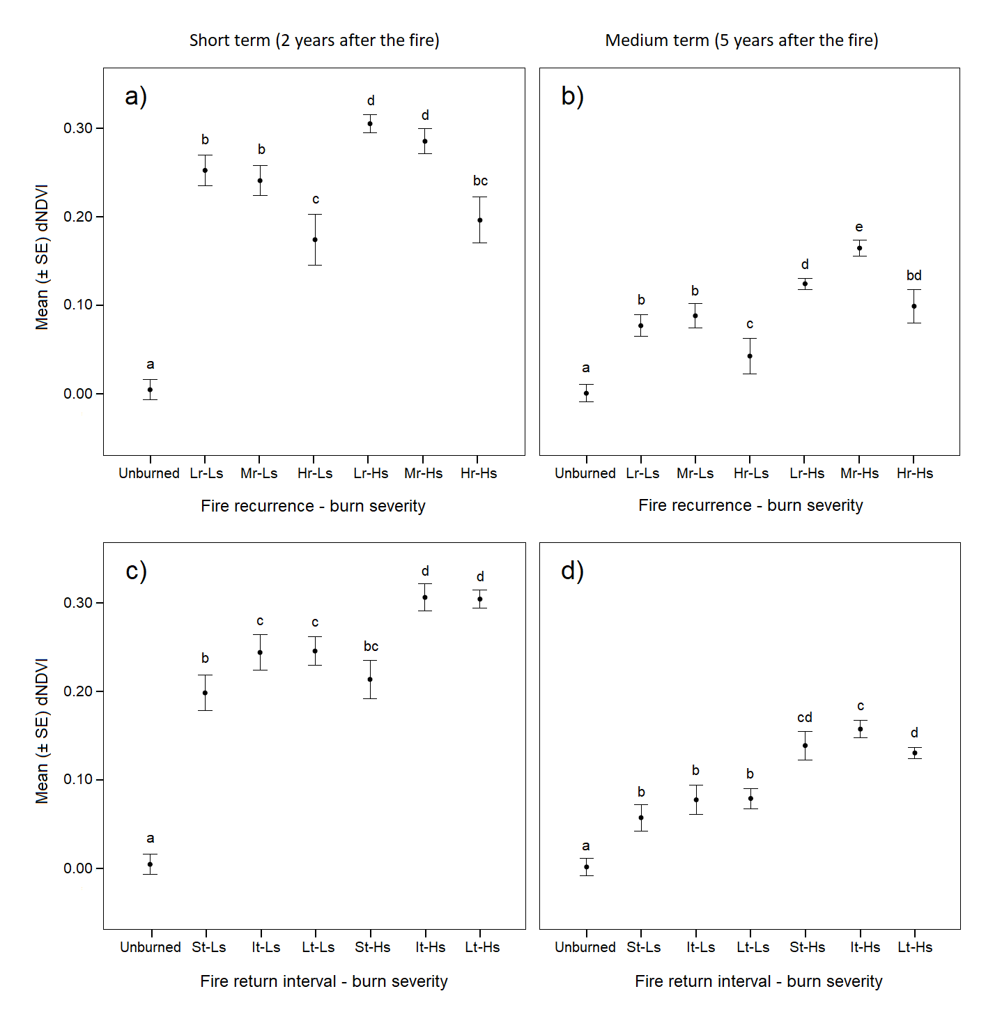
3.3. Effects of Fire Regime Attributes on Post-Fire Greenness Recovery
4. Discussion
5. Conclusions
Author Contributions
Acknowledgments
Conflicts of Interest
References
- Thonicke, K.; Venevsky, S.; Sitch, S.; Cramer, W. The role of fire disturbance for global vegetation dynamics: Coupling fire into a Dynamic Global Vegetation Model. Glob. Ecol. Biogeogr. 2001, 10, 661–677. [Google Scholar] [CrossRef]
- Bond, W.J.; Keeley, J.E. Fire as a global ‘herbivore’: The ecology and evolution of flammable ecosystems. Trends Ecol. Evol. 2005, 20, 387–394. [Google Scholar] [CrossRef] [PubMed]
- Chuvieco, E. Remote Sensing of Large Wildfires in the European Mediterranean Basin; Springer: Berlin, Germany, 1999; pp. 1–212. ISBN 978-3-642-60164-44. [Google Scholar]
- Pausas, J.G.; Llovet, J.; Rodrigo, A.; Vallejo, R. Are wildfires a disaster in the Mediterranean basin?–A review. Int. J. Wildland Fire 2008, 17, 713–723. [Google Scholar] [CrossRef]
- Moreira, F.; Arianoutsou, M.; Corona, P.; De las Heras, J. Post-Fire Management and Restoration of Southern European Forests, Managing Forest Ecosystems; Springer Science + Business Media B.V.: Dordrecht, The Netherlands, 2012; pp. 1–319. ISBN 978-94-007-2208-8. [Google Scholar]
- Richardson, D.M. Ecology and Biogeography of Pinus; Cambridge University Press: Cambridge, UK, 2000; pp. 1–527. ISBN 0521789109. [Google Scholar]
- Tapias, R.; Climent, J.; Pardos, J.A.; Gil, L. Life histories of Mediterranean pines. Plant Ecol. 2004, 171, 53–68. [Google Scholar] [CrossRef]
- Röder, A.; Hill, J.; Duguy, B.; Alloza, J.A.; Vallejo, R. Using long time series of Landsat data to monitor fire events and post-fire dynamics and identify driving factors. A case study in the Ayora region (eastern Spain). Remote Sens. Environ. 2008, 112, 259–273. [Google Scholar] [CrossRef]
- Bergeron, Y.; Leduc, A.; Harvey, B.D.; Gauthier, S. Natural fire regime: A guide for sustainable management of the Canadian boreal forest. Silva Fenn. 2002, 36, 81–95. [Google Scholar] [CrossRef]
- Van Wagtendonk, J.W.; Lutz, J.A. Fire Regime Attributes of Wildland Fires in Yosemite National Park, USA. Fire Ecol. 2007, 3, 34–52. [Google Scholar] [CrossRef]
- Turner, M.G. Disturbance and landscape dynamics in a changing world. Ecology 2010, 91, 2833–2849. [Google Scholar] [CrossRef] [PubMed]
- Eugenio, M.; Verkaik, I.; Lloret, F.; Espelta, J.M. Recruitment and growth decline in Pinus halepensis populations after recurrent wildfires in Catalonia (NE Iberian Peninsula). For. Ecol. Manag. 2006, 231, 47–54. [Google Scholar] [CrossRef]
- Espelta, J.M.; Verkaik, I.; Eugenio, M.; Lloret, F. Recurrent wildfires constrain long-term reproduction ability in Pinus halepensis Mill. Int. J. Wildland Fire 2008, 17, 579–585. [Google Scholar] [CrossRef]
- Fernandes, P.M.; Rigolot, E. The fire ecology and management of maritime pine (Pinus pinaster Ait.). For. Ecol. Manag. 2007, 241, 1–13. [Google Scholar] [CrossRef]
- Keeley, J.E. Resilience of Mediterranean shrub communities to fires. In Resilience in Mediterranean-Type Ecosystems; Dell, B., Hopkins, A.J.M., Lamont, B.B., Eds.; Springer: Dordrecht, The Netherlands, 1986; pp. 95–112. ISBN 978-94-009-4822-8. [Google Scholar]
- Calvo, L.; Baeza, J.; Marcos, E.; Santana, V.; Papanastasis, V.P. Post-Fire management of shrublands. In Post-Fire Management and Restoration of Southern European Forests, Managing Forest Ecosystems; Moreira, F., Arianoutsou, M., Corona, P., De las Heras, J., Eds.; Springer Science + Business Media B.V.: Dordrecht, The Netherlands, 2012; pp. 293–319. ISBN 978-94-007-2208-8. [Google Scholar]
- Tapias, R.; Gil, L.; Fuentes-Utrilla, P.; Pardos, J.A. Canopy seed banks in Mediterranean pines of southeastern Spain: A comparison between Pinus halepensis Mill., P. pinaster Ait., P. nigra Arn. and P. pinea L. J. Ecol. 2001, 89, 629–638. [Google Scholar] [CrossRef]
- González-De Vega, S.; de las Heras, J.; Moya, D. Resilience of Mediterranean terrestrial ecosystems and fire severity in semiarid areas: Responses of Aleppo pine forests in the short, mid and long term. Sci. Total Environ. 2016, 573, 1171–1177. [Google Scholar] [CrossRef] [PubMed]
- Keeley, J.E. Fire intensity, fire severity and burn severity: A brief review and suggested usage. Int. J. Wildland Fire 2009, 18, 116–126. [Google Scholar] [CrossRef]
- Francos, M.; Úbeda, X.; Tort, J.; Panareda, J.M.; Cerdà, A. The role of forest fire severity on vegetation recovery after 18 years. Implications for forest management of Quercus suber L. in Iberian Peninsula. Glob. Planet. Chang. 2016, 145, 11–16. [Google Scholar] [CrossRef]
- Zavala, L.M.; De Celis, R.; Jordán, A. How wildfires affect soil properties. A brief review. Geogr. Res. Lett. 2014, 40, 311–331. [Google Scholar] [CrossRef]
- Taboada, A.; Tárrega, R.; Marcos, E.; Valbuena, L.; Suárez-Seoane, S.; Calvo, L. Fire recurrence and emergency post-fire management influence seedling recruitment and growth by altering plant interactions in fire-prone ecosystems. For. Ecol. Manag. 2017, 402, 63–75. [Google Scholar] [CrossRef]
- Yang, J.; Pan, S.; Dangal, S.; Zhang, B.; Wang, S.; Tian, H. Continental-scale quantification of post-fire vegetation greenness recovery in temperate and boreal North America. Remote Sens. Environ. 2017, 199, 277–290. [Google Scholar] [CrossRef]
- Krasnow, K.; Fry, D.I.; Stephens, S.T. Spatial, temporal and latitudinal components of historical fire regimes in mixed conifer forests, California. J. Biogeogr. 2017, 44, 1239–1253. [Google Scholar] [CrossRef]
- Pausas, J.G.; Fernández-Muñoz, S. Fire regime changes in the Western Mediterranean Basin: From fuel-limited to drought-driven fire regime. Clim. Chang. 2012, 110, 215–226. [Google Scholar] [CrossRef] [Green Version]
- Meddens, A.H.H.; Kolden, C.A.; Lutz, J.A. Detecting unburned areas within wildfire perimeters using Landsat and ancillary data across the northwestern United States. Remote Sens. Environ. 2016, 186, 275–285. [Google Scholar] [CrossRef]
- Soulard, C.E.; Albano, C.M.; Villareal, M.L.; Walker, J.J. Continuous 1985–2012 Landsat Monitoring to Assess Fire Effects on Meadows in Yosemite National Park, California. Remote Sens. 2016, 8, 371. [Google Scholar] [CrossRef]
- Hawbaker, T.J.; Vanderhoof, M.K.; Beal, Y.; Takacs, J.D.; Schmidt, G.L.; Falgout, J.T.; Williams, B.; Fairaux, N.M.; Caldwell, M.K.; Picotte, J.J.; et al. Mapping burned areas using dense time-series of Landsat data. Remote Sens. Environ. 2017, 198, 504–522. [Google Scholar] [CrossRef]
- USGS. Landsat Missions. Available online: https://landsat.usgs.gov/ (accessed on 1 February 2018).
- Bowman, D.M.J.S.; Zhang, Y.; Walsh, A.; Williams, R.J. Experimental comparison of four remote sensing techniques to map tropical savanna fire-scars using Landsat-TM imagery. Int. J. Wildland Fire, 2003, 12, 341–348. [Google Scholar] [CrossRef]
- Bastarrika, A.; Alvarado, M.; Artano, K.; Martinez, M.P.; Mesanza, A.; Torre, L.; Ramo, R.; Chuvieco, E. BAMS: A Tool for Supervised Burned Area Mapping Using Landsat Data. Remote Sens. 2014, 6, 12360–12380. [Google Scholar] [CrossRef]
- Key, C.H. Ecological and sampling constraints on defining landscape fire severity. Fire Ecol. 2006, 2, 34–59. [Google Scholar] [CrossRef]
- Fernández-García, V.; Santamarta, M.; Fernández-Manso, A.; Quintano, C.; Marcos, E.; Calvo, L. Burn severity metrics in fire-prone pine ecosystems along a climatic gradient using Landsat imagery. Remote Sens. Eviron. 2018, 206, 205–217. [Google Scholar] [CrossRef]
- Chu, T.; Guo, X. Remote sensing techniques in monitoring post-fire effects and patterns of forest recovery in boreal forest regions: A review. Remote Sens. 2014, 6, 470–520. [Google Scholar] [CrossRef]
- Parks, S.A.; Dillon, G.K.; Miller, C. A new metric for quantifying burn severity: The relativized burn ratio. Remote Sens. 2014, 6, 1827–1844. [Google Scholar] [CrossRef]
- Key, C.H.; Benson, N.C. Landscape assessment (LA) sampling and analysis methods. In FIREMON: Fire Effects Monitoring and Inventory System; General Technical Report RMRS-GTR-164; USDA Forest Service: Washington, DC, USA, 2006; pp. 1–51. [Google Scholar]
- Miller, J.D.; Thode, A.E. Quantifying burn severity in a heterogeneous landscape with a relative version of the delta normalized burn ratio (dNBR). Remote Sens. Environ. 2007, 109, 66–80. [Google Scholar] [CrossRef]
- Díaz-Delgado, R.; Lloret, F.; Pons, X. Influence of fire severity on plant regeneration by means of remote sensing imagery. Int. J. Remote Sens. 2003, 24, 1751–1763. [Google Scholar] [CrossRef]
- Viana-Soto, A.; Aguado, I.; Martínez, S. Assessment of Post-Fire Vegetation Recovery Using Fire Severity and Geographical Data in the Mediterranean Region (Spain). Environments 2017, 4, 90. [Google Scholar] [CrossRef]
- Donato, D.C.; Fontaine, J.B.; Robinson, W.D.; Kauffmann, J.B.; Law, B.E. Vegetation response to a short interval between high-severity wildfires in a mixed-evergreen forest. J. Ecol. 2009, 97, 142–154. [Google Scholar] [CrossRef]
- Stephens, S.L.; Agee, J.K.; Fulé, P.Z.; North, M.P.; Romme, W.H.; Swetnam, T.W.; Turner, M.G. Managing Forests and Fire in Changing Climates. Science 2013, 342, 41–42. [Google Scholar] [CrossRef] [PubMed]
- Broncano, M.J.; Retana, J. Topography and forest composition affecting variability in fire severity and post-fire regeneration occurring after a large fire in the Mediterranean basin. Int. J. Wildland Fire, 2004, 13, 341–348. [Google Scholar] [CrossRef]
- Wittenberg, L.; Malkinson, D.; Beeri, O.; JHalutzy, A.; Tesler, N. Spatial and temporal patterns of vegetation recovery following sequences of forest fires in a Mediterranean landscape, Mt. Carmel Israel. Catena 2007, 71, 76–83. [Google Scholar] [CrossRef]
- Fernandez-Manso, A.; Quintano, C.; Roberts, D. Burn severity influence on post-fire vegetation cover resilience from Landsat MESMA fraction images time series in Mediterranean forest ecosystems. Remote Sens. Environ. 2016, 184, 112–123. [Google Scholar] [CrossRef]
- Rouse, J.W.; Haas, R.H.; Schell, J.A.; Deering, D.W. Monitoring vegetation systems in the great plains with ERTS. In Proceedings of the Third ERTS Symposium, Washington, DC, USA, 10–14 December 1973; NASA: Washington, DC, USA, 1973; pp. 309–317. [Google Scholar]
- Chuvieco, E. Teledetección ambiental. La observación de la Tierra desde el espacio; Ariel: Barcelona, Spain, 2010; pp. 1–590. ISBN 978-84-344-3498-1. [Google Scholar]
- Malak, D.A.; Pausas, J.P. Fire regime and post-fire Normalized Difference Vegetation Index changes in the eastern Iberian peninsula (Mediterranean basin). Int. J. Wildland Fire 2006, 15, 407–413. [Google Scholar] [CrossRef]
- Santamaría, J.E. El Pino Pinaster de la Sierra del Teleno. Historia, Ordenación, Crecimiento y Producción. Ph.D. Thesis, University of León, León, Spain, 2015. [Google Scholar]
- GEODE. Cartografía Geológica Digital Continua a Escala 1:50.000. Available online: http://info.igme.es/cartografiadigital/geologica/Geode.aspx (accessed on 1 February 2018).
- Air Temperature and Precipitation (1971–2000). Iberian Climate Atlas; Agencia Estatal de Meteorología, Ministerio de Medio Ambiente y Medio Rural y Marino; Instituto de Meteorologia de Portugal: Lisbon, Portugal, 2011; pp. 1–80. ISBN 978-84-7837-079-5. [Google Scholar]
- Ninyerola, M.; Pons, X.; Roure, J.M. Atlas Climático Digital de la Península Ibérica. Metodología y Aplicaciones en Bioclimatología y Geobotánica; Universidad Autónoma de Barcelona: Bellaterra, Spain, 2005; pp. 1–44. ISBN 932860-8-7. [Google Scholar]
- Esri España. ArcGIS. Available online: http://www.esri.es/arcgis/ (accessed on 1 February 2018).
- Ministerio de Agricultura y Pesca. Alimentación y Medio Ambiente. Available online: http://www.mapama.gob.es/es/ (accessed on 1 February 2018).
- Miller, J.D.; Yool, S.R. Mapping forest post-fire canopy consumption in several overstory types using multi-temporal Landsat TM and ETM data. Remote Sens. Environ. 2002, 82, 481–496. [Google Scholar] [CrossRef]
- Ali, S.M.; Salman, S.S. Chronological Calibration Methods for Landsat Satellite Images. J. Appli. Phys. 2015, 7, 107–105. [Google Scholar] [CrossRef]
- Quintano, C.; Fernández-Manso, A.; Calvo, L.; Marcos, E.; Valbuena, L. Land Surface temperature as potential indicator of burn severity in forest Mediterranean ecosystems. Int. J. Appl. Earth Obs. Geoinfor. 2015, 36, 1–12. [Google Scholar] [CrossRef]
- Hope, A.; Tague, C.; Clark, R. Characterizing post-fire vegetation recovery of California chaparral using TM/ETM+ time-series data. Int. J. Remote Sens. 2007, 28, 1339–1354. [Google Scholar] [CrossRef]
- Quintano, C.; Fernández-Manso, A.; Roberts, D.A. Multiple Endmember Spectral Mixture Analysis (MESMA) to map burn severity levels from Landsat images in Mediterranean countries. Remote Sens. Environ. 2013, 136, 76–88. [Google Scholar] [CrossRef]
- Diniz-Filho, J.A.F.; Siqueira, T.; Padial, A.A.; Rangel, T.F.; Landeiro, V.L.; Bini, L.M. Spatial autocorrelation analysis allows disentangling the balance between neutral and niche processes in metacommunities. Oikos 2011, 121, 201–210. [Google Scholar] [CrossRef]
- R Core Team. R: A Language and Environment for Statistical Computing. R Foundation for Statistical Computing. 2017. Available online: http://www.R-project.org/ (accessed on 1 October 2017).
- Bivand, R.; Piras, G. Comparing Implementations of Estimation Methods for Spatial Econometrics. J. Stat. Softw. 2015, 63, 1–36. [Google Scholar] [CrossRef]
- San-Miguel-Ayanz, J.; Durrant, T.; Boca, R.; Libertà, G.; Bocacci, F.; Di Leo, M.; López-Pérez, J.; Schulte, E. Forest Fires in Europe, Middle East and North Africa 2015; EUR 28158EN, Joint Research Center of the European Commission Technical Reports; EU Publications: Luxembourg, 2016. [Google Scholar] [CrossRef]
- Pausas, J.G. Changes in fire and climate in the Eastern Iberian Peninsula (Mediterranean Basin). Clim. Chang. 2004, 63, 337–350. [Google Scholar] [CrossRef]
- Pausas, J.G.; Paula, S. Fuel shapes the fire-climate relationship: Evidence from Mediterranean ecosystems. Global Ecol. Biogeogr. 2012, 21, 1074–1082. [Google Scholar] [CrossRef]
- Bowman, D.M.J.S.; Williamson, G.J.; Abatzoglou, J.T.; Kolden, C.A.; Cochrane, M.A.; Smith, A.M. Human exposure and sensitivity to globally extreme wildfire events. Nat. Ecol. Evol. 2017, 1, 0058. [Google Scholar] [CrossRef] [PubMed]
- Lucas-Borja, M.E.; Ahrazem, O.; Candel-Pérez, D.; Moya, D.; Fonseca, T.; Hernández Teclés, E.; De las Heras, J.; Gómez-Gómez, L. Evaluation of fire recurrence effect on genetic diversity in maritime pine (Pinus pinaster Ait.) stands using Inter-Simple Sequence Repeat profiles. Sci. Total Environ. 2016, 572, 1322–1328. [Google Scholar] [CrossRef] [PubMed]
- Tessler, N.; Sapir, Y.; Witenberg, L.; Greenbaum, N. Recovery of Mediterranean vegetation after recurrent forest fires: Insight from the 2010 forest fire on Mount Carmel, Israel. Land Degrad. Dev. 2016, 27, 1424–1431. [Google Scholar] [CrossRef]
- SIOSE. Sistema de Información sobre Ocupación del Suelo de España, 2011. Available online: http://www.siose.es/ (accessed on 1 February 2018).
- Calvo, L.; Santalla, S.; Valbuena, L.; Marcos, E.; Tárrega, R.; Luis-Calabuig, E. Post-fire natural regeneration of a Pinus pinaster forest in NW Spain. Plant Ecol. 2008, 197, 81–90. [Google Scholar] [CrossRef]
- Rodrigo, A.; Retana, J.; Picó, F.X. Direct regeneration is not the only response of Mediterranean forests to large fires. Ecology 2004, 85, 716–729. [Google Scholar] [CrossRef]
- Pausas, J.G. Response of plant functional types to changes in the fire regime in Mediterranean ecosystems: A simulation approach. J. Veg. Sci. 1999, 10, 717–722. [Google Scholar] [CrossRef]
- Quintano, C.; Fernandez-Manso, A.; Roberts, D.A. Burn severity mapping from Landsat MESMA fraction images and Land Surface Temperature. Remote Sens. Environ. 2017, 190, 83–95. [Google Scholar] [CrossRef]
- Maia, P.; Pausas, J.G.; Vasques, A.; Keizer, J.J. Fire severity as a key factor in post-fire regeneration of Pinus pinaster (Ait.) in Central Portugal. Ann. For. Sci. 2012, 69, 489–498. [Google Scholar] [CrossRef]
- Calvo, L.; Tárrega, R.; de Luis, E. Secondary succession after perturbations in a shrubland community. Acta Oecol. 2002, 23, 393–404. [Google Scholar] [CrossRef]
- Johnstone, J.F.; Allen, C.D.; Franklin, J.F.; Frelich, L.E.; Harvey, B.J.; Higuera, P.E.; Mack, M.C.; Meentemeyer, R.K.; Metz, M.R.; Perry, G.L.W.; et al. Changing disturbance regimes, ecological memory, and forest resilience. Front. Ecol. Environ. 2016, 14, 369–378. [Google Scholar] [CrossRef]
- Moreira, F.; Viedma, O.; Arianoutsou, M.; Curt, T.; Koutsias, N.; Rigolot, E.; Barbati, A.; Corona, P.; Vaz, P.; Xanthopoulos, G.; et al. Landscape-wildfire interactions in southern Europe: Implications for landscape management. J. Environ. Manag. 2011, 92, 2389–2402. [Google Scholar] [CrossRef] [PubMed] [Green Version]


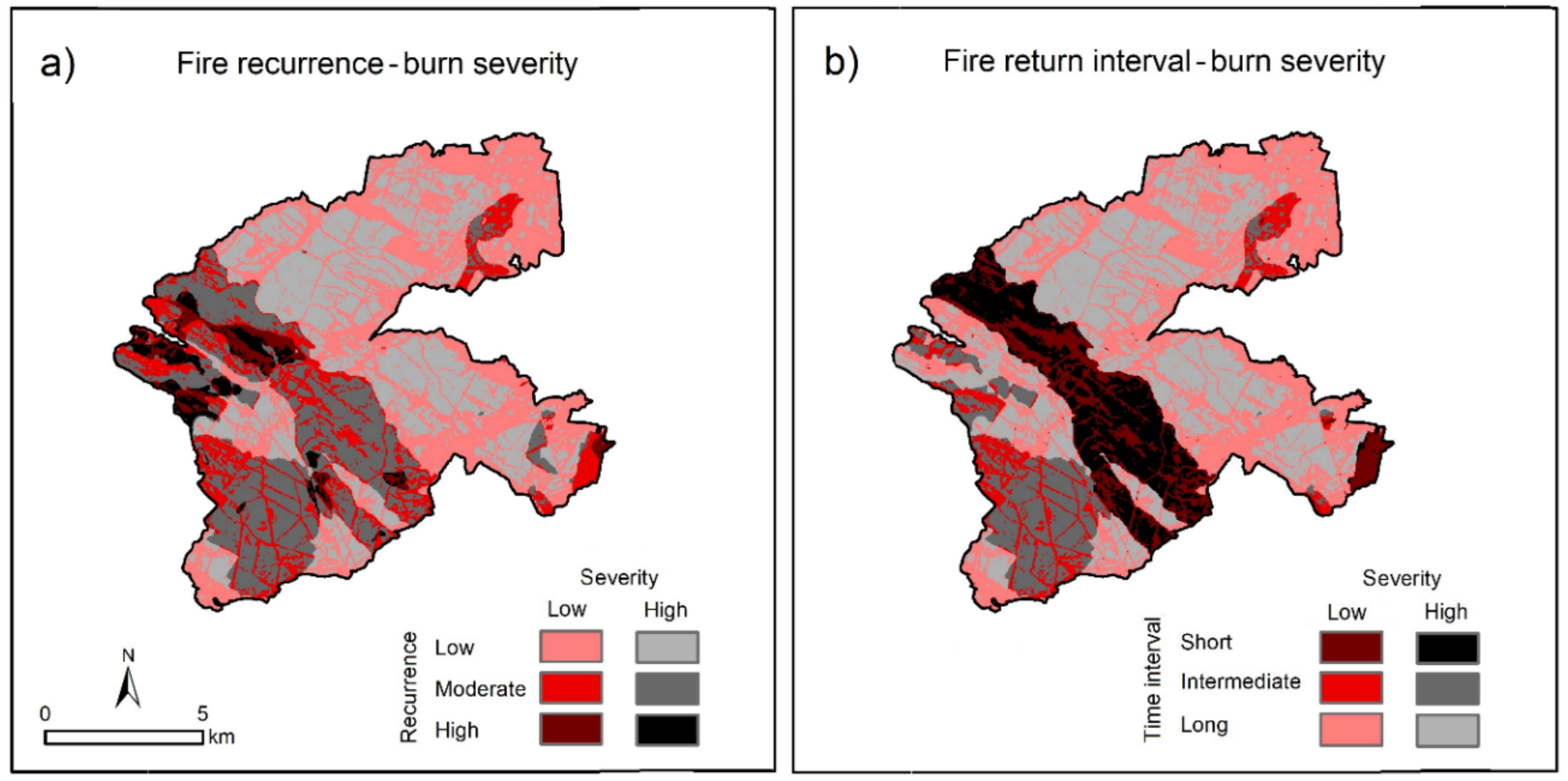
| Response Variable | Predictor Variable | Df | R2 | F-value | p-value |
|---|---|---|---|---|---|
| dNDVI (2011–2014) | Fire recurrence | 3 | 0.348 | 177.522 | <0.001 |
| Fire return interval | 3 | 0.352 | 180.058 | <0.001 | |
| Burn severity | 2 | 0.338 | 254.305 | <0.001 | |
| Fire recurrence-burn severity | 6 | 0.380 | 101.405 | <0.001 | |
| Fire return interval-burn severity | 6 | 0.394 | 107.361 | <0.001 | |
| dNDVI (2011–2017) | Fire recurrence | 3 | 0.193 | 79.529 | <0.001 |
| Fire return interval | 3 | 0.142 | 55.070 | <0.001 | |
| Burn severity | 2 | 0.272 | 186.045 | <0.001 | |
| Fire recurrence-burn severity | 6 | 0.313 | 75.279 | <0.001 | |
| Fire return interval-burn severity | 6 | 0.287 | 66.604 | <0.001 |
© 2018 by the authors. Licensee MDPI, Basel, Switzerland. This article is an open access article distributed under the terms and conditions of the Creative Commons Attribution (CC BY) license (http://creativecommons.org/licenses/by/4.0/).
Share and Cite
Fernández-García, V.; Quintano, C.; Taboada, A.; Marcos, E.; Calvo, L.; Fernández-Manso, A. Remote Sensing Applied to the Study of Fire Regime Attributes and Their Influence on Post-Fire Greenness Recovery in Pine Ecosystems. Remote Sens. 2018, 10, 733. https://0-doi-org.brum.beds.ac.uk/10.3390/rs10050733
Fernández-García V, Quintano C, Taboada A, Marcos E, Calvo L, Fernández-Manso A. Remote Sensing Applied to the Study of Fire Regime Attributes and Their Influence on Post-Fire Greenness Recovery in Pine Ecosystems. Remote Sensing. 2018; 10(5):733. https://0-doi-org.brum.beds.ac.uk/10.3390/rs10050733
Chicago/Turabian StyleFernández-García, Víctor, Carmen Quintano, Angela Taboada, Elena Marcos, Leonor Calvo, and Alfonso Fernández-Manso. 2018. "Remote Sensing Applied to the Study of Fire Regime Attributes and Their Influence on Post-Fire Greenness Recovery in Pine Ecosystems" Remote Sensing 10, no. 5: 733. https://0-doi-org.brum.beds.ac.uk/10.3390/rs10050733