A National Assessment of Wetland Status and Trends for Canada’s Forested Ecosystems Using 33 Years of Earth Observation Satellite Data

 , , , , , and
Abstract
:
1. Introduction
2. Methods
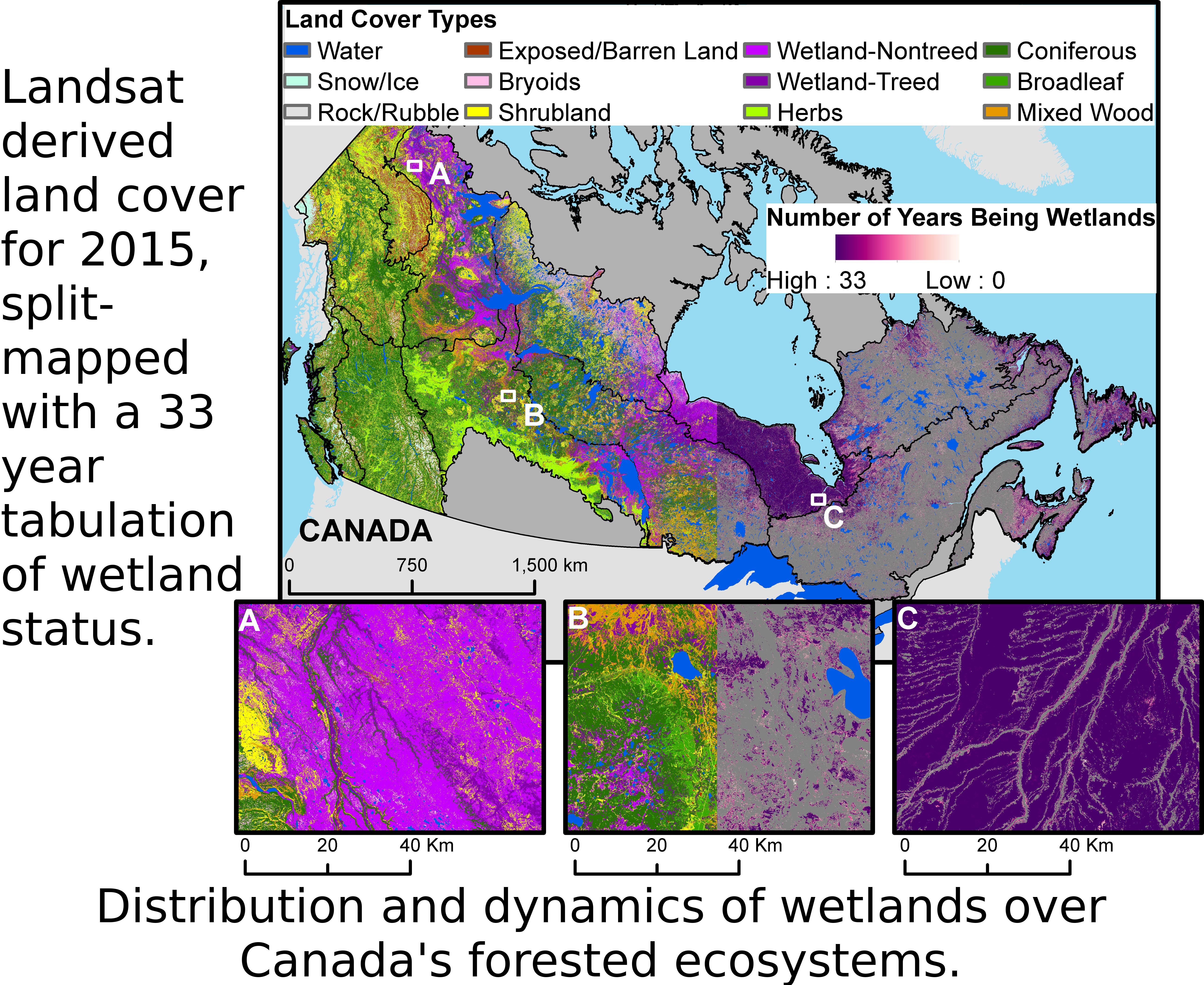
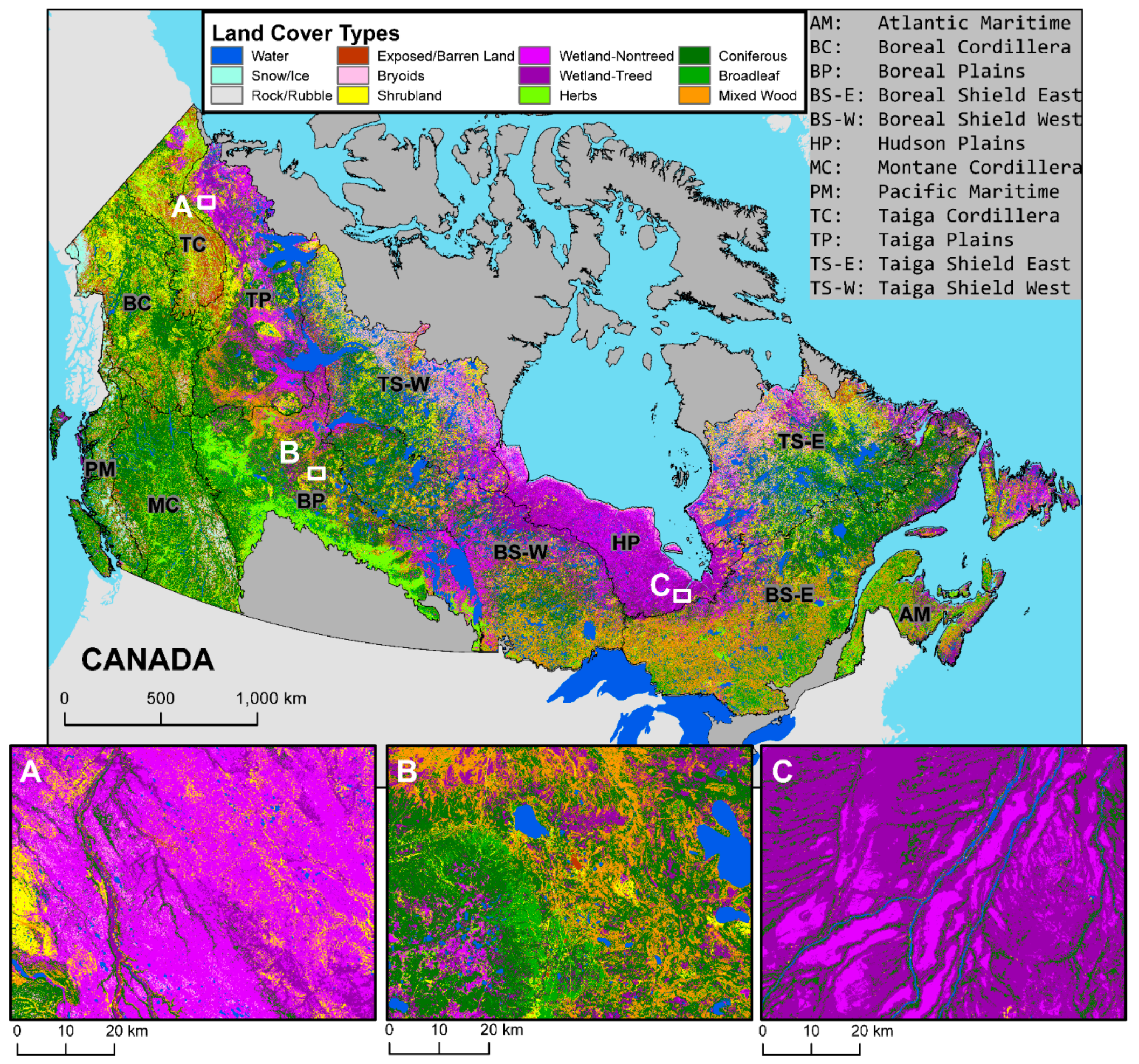
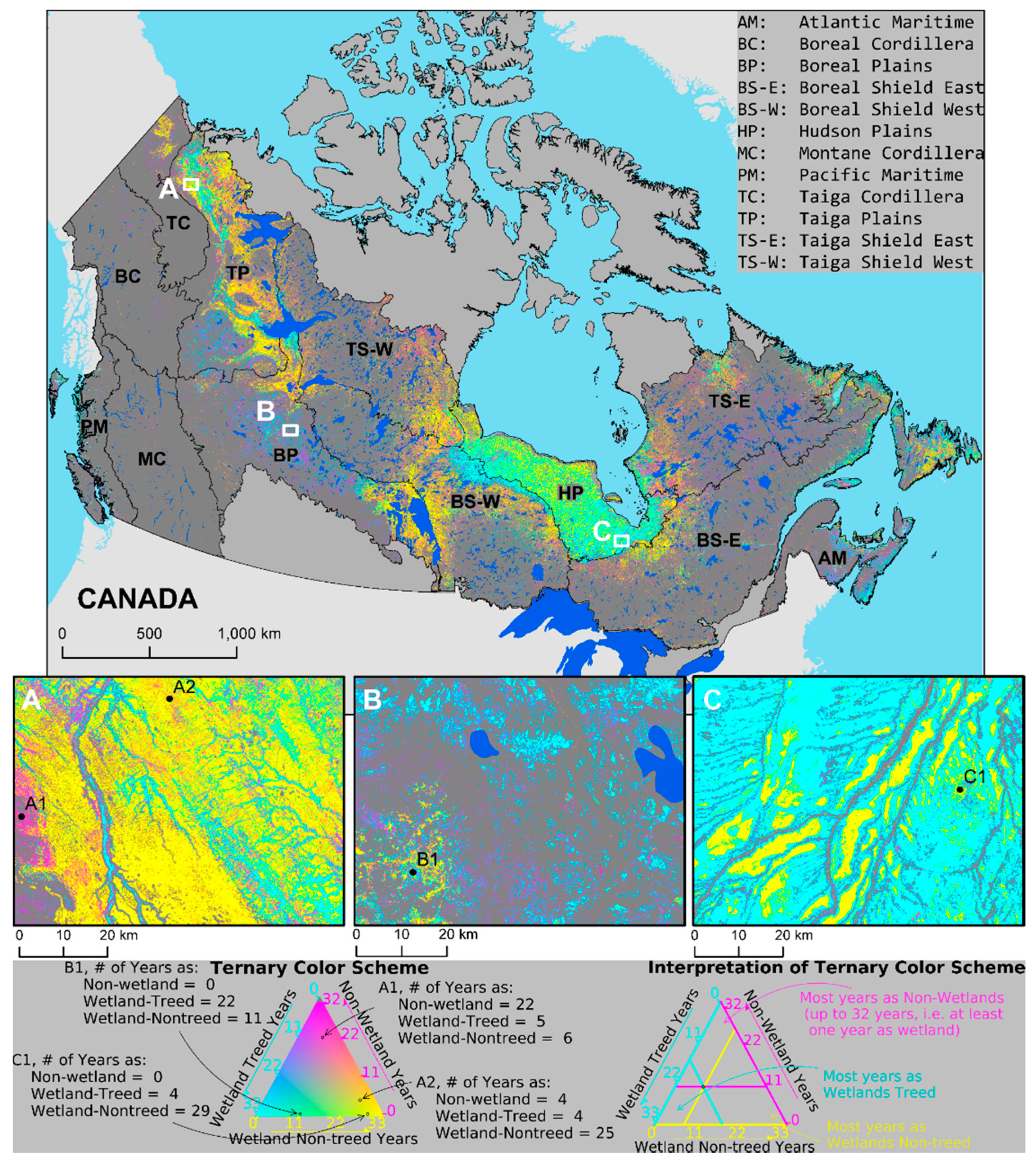
2.1. Study Area
2.2. Data
2.3. Analysis
3. Results
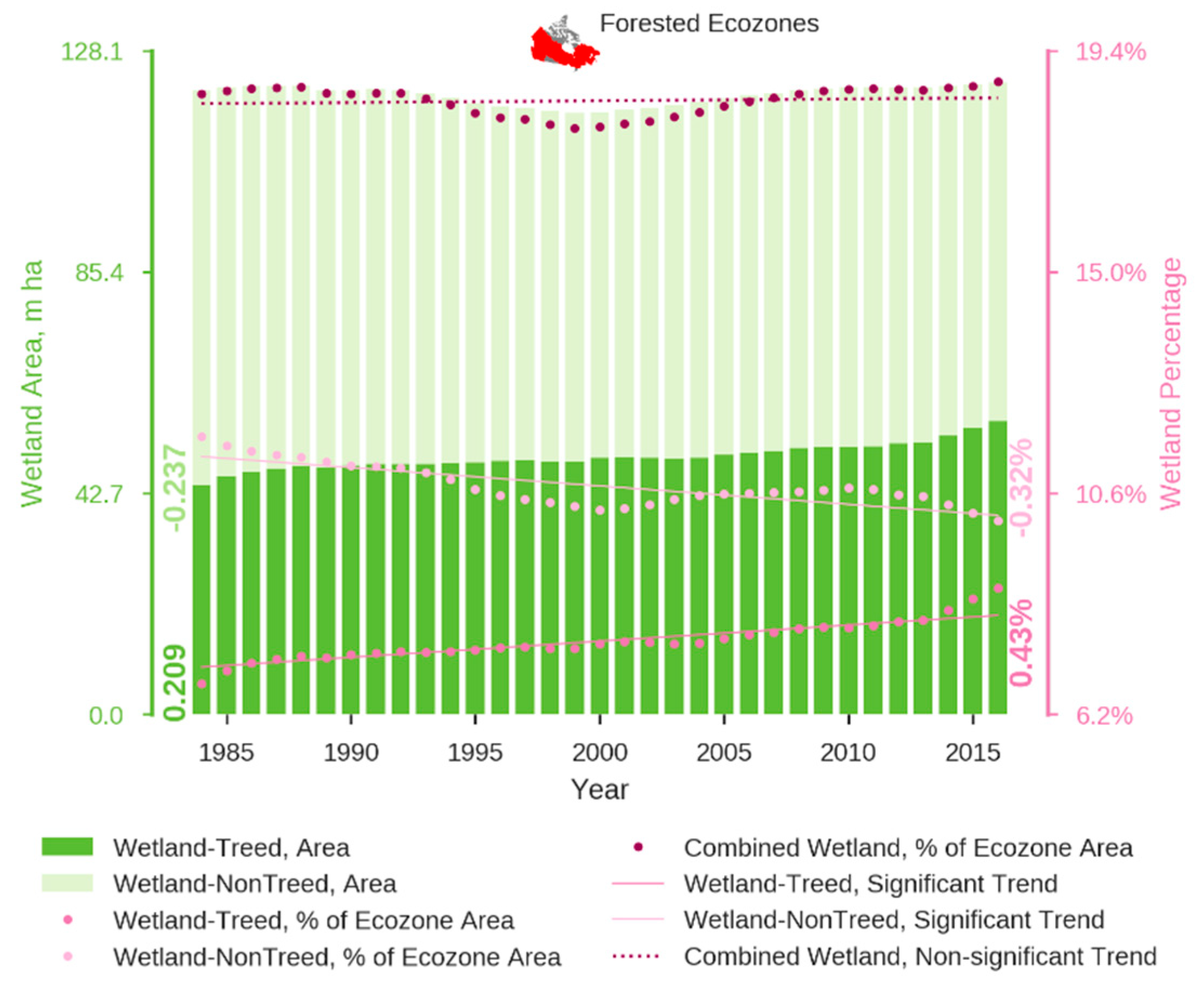
3.1. Time Series of Wetland Extent
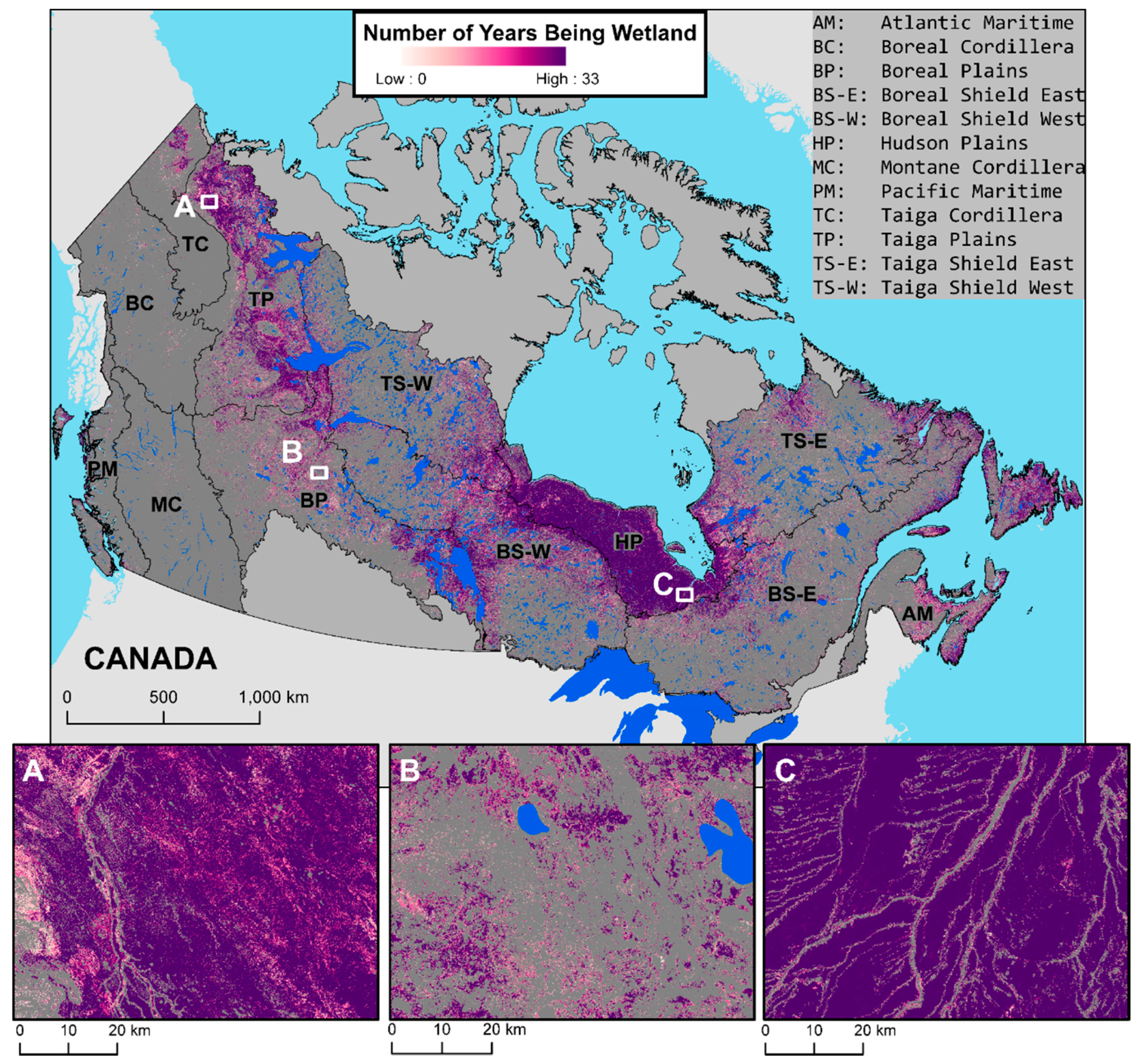
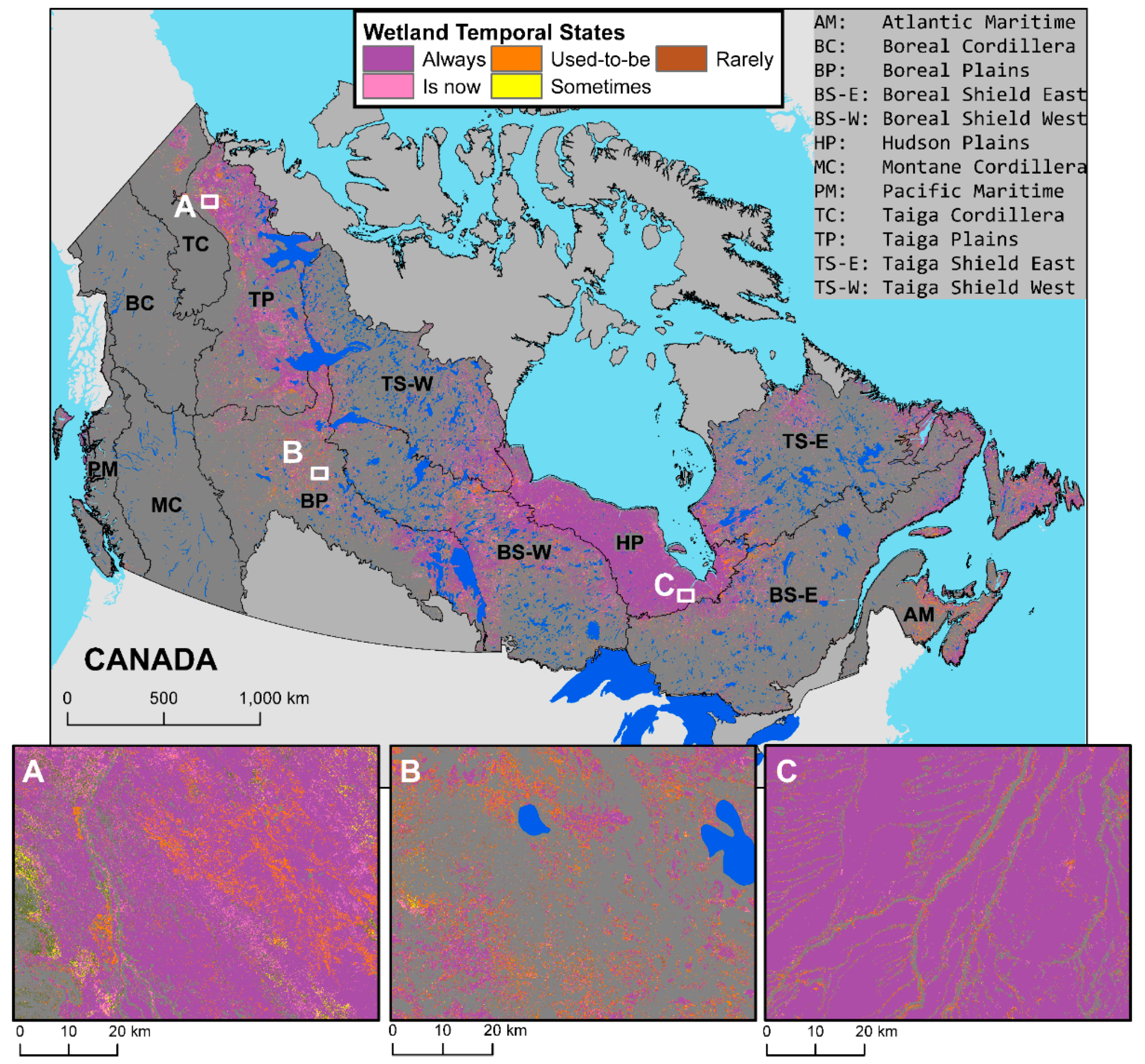
3.2. Spatial Patterns of Wetland Change
4. Discussion
5. Conclusions
Author Contributions
Funding
Acknowledgments
Conflicts of Interest
References
- Mitsch, W.J.; Bernal, B.; Nahlik, A.M.; Mander, Ü.; Zhang, L.; Anderson, C.J.; Jørgensen, S.E.; Brix, H. Wetlands, carbon, and climate change. Landsc. Ecol. 2013, 28, 583–597. [Google Scholar] [CrossRef]
- Comyn-Platt, E.; Hayman, G.; Huntingford, C.; Chadburn, S.E.; Burke, E.J.; Harper, A.B.; Collins, W.J.; Webber, C.P.; Powell, T.; Cox, P.M.; et al. Carbon budgets for 1.5 and 2 °C targets lowered by natural wetland and permafrost feedbacks. Nat. Geosci. 2018, 11, 568–573. [Google Scholar] [CrossRef]
- Kuhn, M.; Lundin, E.J.; Giesler, R.; Johansson, M.; Karlsson, J. Emissions from thaw ponds largely offset the carbon sink of northern permafrost wetlands. Sci. Rep. 2018, 8, 9535. [Google Scholar] [CrossRef] [PubMed]
- Vanderhoof, M.K.; Lane, C.R.; McManus, M.G.; Alexander, L.C.; Christensen, J.R. Wetlands inform how climate extremes influence surface water expansion and contraction. Hydrol. Earth Syst. Sci. 2018, 22, 1851–1873. [Google Scholar] [CrossRef] [Green Version]
- Mitsch, W.J.; Gosselink, J.G. Wetlands, 4th ed.; John Wiley & Sons, Inc.: Hoboken, NJ, USA, 2007; ISBN 978-1-118-67682-0. [Google Scholar]
- National Wetlands Working Group. The Canadian Wetland Classification System, 2nd ed.; Warner, B.G., Rubec, C.D.A., Eds.; National Wetlands Working Group: Waterloo, ON, Canada, 1997. [Google Scholar]
- Ramsar Convention Secretariat. The Ramsar Convention Manual, 6th ed.; Ramsar Convention Secretariat: Gland, Switzerland, 2013; ISBN 9789400705500. [Google Scholar]
- Environment and Climate Change Canada. Canadian Environmental Sustainability Indicators: Extent of Canada’s Wetlands; Environment and Climate Change Canada: Ottawa, ON, Canada, 2016. [Google Scholar]
- Wulder, M.A.; White, J.C.; Cranny, M.; Hall, R.J.; Luther, J.E.; Beaudoin, A.; Goodenough, D.G.; Dechka, J.A. Monitoring Canada’s forests. Part 1: Completion of the EOSD land cover project. Can. J. Remote Sens. 2008, 34, 549–562. [Google Scholar] [CrossRef]
- Brandt, J.P.; Flannigan, M.D.; Maynard, D.G.; Thompson, I.D.; Volney, W.J.A. An introduction to Canada’s boreal zone: Ecosystem processes, health, sustainability, and environmental issues. Environ. Rev. 2013, 21, 207–226. [Google Scholar] [CrossRef]
- Environment and Climate Change Canada Environmental Indicators: Wildlife and Habitat Indicators. Available online: https://www.canada.ca/en/environment-climate-change/services/environmental-indicators/wildlife-habitat.html (accessed on 27 August 2018).
- Government of Canada. The Federal Policy on Wetland Conservation; Director General; Canadian Wildlife Service, Environment Canada: Ottawa, ON, Canada, 1991; ISBN 066218940X.
- Zoltai, S.C.; Pollett, F.C. Wetlands in Canada: Their Classification, Distribution, and Use. In Ecosystems of the World 4B. Mires: Swamp, Bog, Fen and Moor. Regional Studies; Gore, A.P., Ed.; Elsevier Scientific Publishing Company: Amsterdam, The Netherland, 1983; pp. 245–268. ISBN 0-444-420-04-5. [Google Scholar]
- Tiner, R.W.; Lang, M.W.; Klemas, V.V. Remote Sensing of Wetlands: Applications and Advances; CRC Press: Boca Raton, FL, USA, 2015; ISBN 1482237385. [Google Scholar]
- Gallant, L.A. The Challenges of Remote Monitoring of Wetlands. Remote Sens. 2015, 7, 10938–10950. [Google Scholar] [CrossRef] [Green Version]
- Moffett, B.K.; Nardin, W.; Silvestri, S.; Wang, C.; Temmerman, S. Multiple Stable States and Catastrophic Shifts in Coastal Wetlands: Progress, Challenges, and Opportunities in Validating Theory Using Remote Sensing and Other Methods. Remote Sens. 2015, 7, 10184–10226. [Google Scholar] [CrossRef] [Green Version]
- Baker, C.; Lawrence, R.L.; Montagne, C.; Patten, D. Change detection of wetland ecosystems using Landsat imagery and change vector analysis. Wetlands 2007, 27, 610–619. [Google Scholar] [CrossRef]
- Frohn, R.C.; Reif, M.; Lane, C.; Autrey, B. Satellite remote sensing of isolated wetlands using object-oriented classification of Landsat-7 data. Wetlands 2009, 29, 931–941. [Google Scholar] [CrossRef]
- Dingle Robertson, L.; King, D.J.; Davies, C. Assessing Land Cover Change and Anthropogenic Disturbance in Wetlands Using Vegetation Fractions Derived from Landsat 5 TM Imagery (1984–2010). Wetlands 2015, 35, 1077–1091. [Google Scholar] [CrossRef]
- Lunetta, R.S.; Balogh, M.E. Application of multi-temporal Landsat 5 TM imagery for wetland identification. Photogramm. Eng. Remote Sens. 1999, 65, 1303–1310. [Google Scholar]
- Li, J.; Chen, W. A rule-based method for mapping Canada’s wetlands using optical, radar and DEM data. Int. J. Remote Sens. 2005, 26, 5051–5069. [Google Scholar] [CrossRef]
- Ozesmi, S.L.; Bauer, M.E. Satellite remote sensing of wetlands. Wetl. Ecol. Manag. 2002, 10, 381–402. [Google Scholar] [CrossRef]
- Rogers, A.S.; Kearney, M.S. Reducing signature variability in unmixing coastal marsh Thematic Mapper scenes using spectral indices. Int. J. Remote Sens. 2004, 25, 2317–2335. [Google Scholar] [CrossRef]
- Wulder, M.A.; White, J.C.; Loveland, T.R.; Woodcock, C.E.; Belward, A.S.; Cohen, W.B.; Fosnight, E.A.; Shaw, J.; Masek, J.G.; Roy, D.P. The global Landsat archive: Status, consolidation, and direction. Remote Sens. Environ. 2016, 185, 271–283. [Google Scholar] [CrossRef]
- Wulder, M.A.; Coops, N.C.; Roy, D.P.; White, J.C.; Hermosilla, T. Land cover 2.0. Int. J. Remote Sens. 2018, 39, 4254–4284. [Google Scholar] [CrossRef] [Green Version]
- Hermosilla, T.; Wulder, M.A.; White, J.C.; Coops, N.C.; Hobart, G.W. Disturbance-Informed Annual Land Cover Classification Maps of Canada’s Forested Ecosystems for a 29-Year Landsat Time Series. Can. J. Remote Sens. 2018, 44, 1–21. [Google Scholar] [CrossRef]
- Ecological Stratification Working Group. A National Ecological Framework for Canada; Agriculture and Agri-Foods Canada, Research Branch, Centre for land and Biological Resources Research and Environment Canada, State of the Environment Directorate, Ecozone Analysis Branch: Ottawa, ON, Canada; Hull, UK, 1995; ISBN 066224107X. [Google Scholar]
- Stinson, G.; Kurz, W.A.; Smyth, C.E.; Neilson, E.T.; Dymond, C.C.; Metsaranta, J.M.; Boisvenue, C.; Rampley, G.J.; Li, Q.; White, T.M.; et al. An inventory-based analysis of Canada’s managed forest carbon dynamics, 1990 to 2008. Glob. Chang. Biol. 2011, 17, 2227–2244. [Google Scholar] [CrossRef]
- Frazier, R.J.; Coops, N.C.; Wulder, M.A.; Hermosilla, T.; White, J.C. Analyzing spatial and temporal variability in short-term rates of post-fire vegetation return from Landsat time series. Remote Sens. Environ. 2018, 205, 32–45. [Google Scholar] [CrossRef]
- Natural Resource Canada. The State of Canada’s Forests Annual Report 2017; Natural Resource Canada: Ottawa, ON, Canada, 2017. [Google Scholar]
- Coops, N.C.; Wulder, M.A.; Iwanicka, D. An environmental domain classification of Canada using earth observation data for biodiversity assessment. Ecol. Inform. 2009, 4, 8–22. [Google Scholar] [CrossRef]
- Glooschenko, W.A.; Tarnocai, C.; Zoltai, S.; Glooschenko, V. Wetlands of Canada and Greenland BT—Wetlands of the World: Inventory, Ecology and Management Volume I: Africa, Australia, Canada and Greenland, Mediterranean, Mexico, Papua New Guinea, South Asia, Tropical South America, United States; Whigham, D.F., Dykyjová, D., Hejný, S., Eds.; Springer: Dordrecht, The Netherlands, 1993; pp. 415–514. ISBN 978-94-015-8212-4. [Google Scholar]
- White, J.C.; Wulder, M.A.; Hobart, G.W.; Luther, J.E.; Hermosilla, T.; Griffiths, P.; Coops, N.C.; Hall, R.J.; Hostert, P.; Dyk, A.; et al. Pixel-based image compositing for large-area dense time series applications and science. Can. J. Remote Sens. 2014, 40, 192–212. [Google Scholar] [CrossRef]
- Hermosilla, T.; Wulder, M.A.; White, J.C.; Coops, N.C.; Hobart, G.W. An integrated Landsat time series protocol for change detection and generation of annual gap-free surface reflectance composites. Remote Sens. Environ. 2015, 158, 220–234. [Google Scholar] [CrossRef]
- Hermosilla, T.; Wulder, M.A.; White, J.C.; Coops, N.C.; Hobart, G.W.; Campbell, L.B. Mass data processing of time series Landsat imagery: Pixels to data products for forest monitoring. Int. J. Digit. Earth 2016, 9, 1035–1054. [Google Scholar] [CrossRef]
- NASA LP DAAC AST_L1T: ASTER Level 1 Precision Terrain Corrected Registered At-Sensor Radiance V003. Available online: https://lpdaac.usgs.gov/node/1091 (accessed on 27 August 2018).
- Abercrombie, S.P.; Friedl, M.A. Improving the Consistency of Multitemporal Land Cover Maps Using a Hidden Markov Model. IEEE Trans. Geosci. Remote Sens. 2016, 54, 703–713. [Google Scholar] [CrossRef]
- Olofsson, P.; Foody, G.M.; Herold, M.; Stehman, S.V.; Woodcock, C.E.; Wulder, M.A. Good practices for estimating area and assessing accuracy of land change. Remote Sens. Environ. 2014, 148, 42–57. [Google Scholar] [CrossRef] [Green Version]
- Sen, P.K. Estimates of the Regression Coefficient Based on Kendall’s Tau. J. Am. Stat. Assoc. 1968, 63, 1379–1389. [Google Scholar] [CrossRef]
- Kendall, M.; Gibbons, J.D. Rank Correlation Methods, 5th ed.; Edward Arnold: London, UK, 1990. [Google Scholar]
- Coops, N.C.; Hermosilla, T.; Wulder, M.A.; White, J.C.; Bolton, D.K. A thirty year, fine-scale, characterization of area burned in Canadian forests shows evidence of regionally increasing trends in the last decade. PLoS ONE 2018, 13, 1–19. [Google Scholar] [CrossRef] [PubMed]
- McCarthy, M.J.; Radabaugh, K.R.; Moyer, R.P.; Muller-Karger, F.E. Enabling efficient, large-scale high-spatial resolution wetland mapping using satellites. Remote Sens. Environ. 2018, 208, 189–201. [Google Scholar] [CrossRef]
- Zhang, X.; Treitz, P.M.; Chen, D.; Quan, C.; Shi, L.; Li, X. Mapping mangrove forests using multi-tidal remotely-sensed data and a decision-tree-based procedure. Int. J. Appl. Earth Obs. Geoinf. 2017, 62, 201–214. [Google Scholar] [CrossRef]
- Liu, T.; Abd-Elrahman, A. Multi-view object-based classification of wetland land covers using unmanned aircraft system images. Remote Sens. Environ. 2018, 216, 122–138. [Google Scholar] [CrossRef]
- Kayastha, N.; Thomas, V.; Galbraith, J.; Banskota, A. Monitoring Wetland Change Using Inter-Annual Landsat Time-Series Data. Wetlands 2012, 32, 1149–1162. [Google Scholar] [CrossRef]
- White, J.C.; Wulder, M.A. The landsat observation record of Canada: 1972 2012. Can. J. Remote Sens. 2014, 39, 455–467. [Google Scholar] [CrossRef]
- Arvidson, T.; Gasch, J.; Goward, S.N. Landsat 7’s long-term acquisition plan—An innovative approach to building a global imagery archive. Remote Sens. Environ. 2001, 78, 13–26. [Google Scholar] [CrossRef]
- White, L.; Brisco, B.; Dabboor, M.; Schmitt, A.; Pratt, A. A Collection of SAR Methodologies for Monitoring Wetlands. Remote Sens. 2015, 7, 7615–7645. [Google Scholar] [CrossRef] [Green Version]
- Spooner, I.; Principato, S.; Hill, N.; White, H.; Dunnington, D.; Neily, T.; Stolze, S. Late Holocene Records of Changing Moisture Regime from Wetlands in Southwestern Nova Scotia, Canada: Implications for Wetland Conservation and Restoration. Northeast. Nat. 2017, 24, 331–348. [Google Scholar] [CrossRef]
- Prigent, C.; Matthews, E.; Aires, F.; Rossow, W.B. Remote sensing of global wetland dynamics with multiple satellite data sets. Geophys. Res. Lett. 2001, 28, 4631–4634. [Google Scholar] [CrossRef] [Green Version]
- Murkin, H.R.; Murkin, E.J.; Ball, J.P. Avian habitat selection and Prarie wetland dynamics: A 10 year experiment. Ecol. Appl. 1997, 7, 1144–1159. [Google Scholar] [CrossRef]
- Agriculture and Agri-Food Canada Canadian Drought Monitor. Available online: https://open.canada.ca/data/en/dataset/292646cd-619f-4200-afb1-8b2c52f984a2 (accessed on 4 September 2018).
- Poiani, K.A.; Johnson, W.C. Global Warming and Prairie Wetlands Potential consequences for waterfowl habitat. Wetlands 2012, 41, 611–618. [Google Scholar]
- Stewart, R.E.; Kantrud, H.A. Classification of Natural Ponds and Lakes in the Glaciated Prairie Region; U.S. Fish and Wildlife Service, Bureau of Sport Fisheries and Wildlife: Washington, DC, USA, 1971; Volume 554.
- Fay, P.A.; Guntenspergen, G.R.; Olker, J.H.; Carter Johnson, W. Climate change impacts on freshwater wetland hydrology and vegetation cover cycling along a regional aridity gradient. Ecosphere 2016, 7. [Google Scholar] [CrossRef]
- Johnson, W.C.; Poiani, K.A. Climate Change Effects on Prairie Pothole Wetlands: Findings from a Twenty-five Year Numerical Modeling Project. Wetlands 2016, 36, 273–285. [Google Scholar] [CrossRef]
- Allen, C.D.; Macalady, A.K.; Chenchouni, H.; Bachelet, D.; McDowell, N.; Vennetier, M.; Kitzberger, T.; Rigling, A.; Breshears, D.D.; Hogg, E.H.; et al. A global overview of drought and heat-induced tree mortality reveals emerging climate change risks for forests. For. Ecol. Manag. 2010, 259, 660–684. [Google Scholar] [CrossRef]
- Michaelian, M.; Hogg, E.H.; Hall, R.J.; Arsenault, E. Massive mortality of aspen following severe drought along the southern edge of the Canadian boreal forest. Glob. Chang. Biol. 2010, 17, 2084–2094. [Google Scholar] [CrossRef] [Green Version]
- Pekel, J.-F.; Cottam, A.; Gorelick, N.; Belward, A.S. High-resolution mapping of global surface water and its long-term changes. Nature 2016, 540, 418–422. [Google Scholar] [CrossRef] [PubMed]
- Asong, Z.E.; Wheater, H.S.; Bonsal, B.; Razavi, S.; Kurkute, S. Historical drought patterns over Canada and their teleconnections with large-scale climate signals. Hydrol. Earth Syst. Sci. 2018, 22, 3105–3124. [Google Scholar] [CrossRef]
- Vitt, D.H.; Halsey, L.A.; Zoltai, S.C. The changing landscape of Canada’s western boreal forest: The current dynamics of permafrost. Can. J. For. Res. 2000, 30, 283–287. [Google Scholar] [CrossRef]
- Camill, P. Permafrost Thaw Accelerates in Boreal Peatlands During Late-20th Century Climate Warming. Clim. Chang. 2005, 68, 135–152. [Google Scholar] [CrossRef]
- Lawrence, D.M.; Koven, C.D.; Swenson, S.C.; Riley, W.J.; Slater, A.G. Permafrost thaw and resulting soil moisture changes regulate projected high-latitude CO2 and CH4 emissions. Environ. Res. Lett. 2015, 10, 094011. [Google Scholar] [CrossRef]
- Helbig, M.; Wischnewski, K.; Kljun, N.; Chasmer, L.E.; Quinton, W.L.; Detto, M.; Sonnentag, O. Regional atmospheric cooling and wetting effect of permafrost thaw-induced boreal forest loss. Glob. Chang. Biol. 2016, 22, 4048–4066. [Google Scholar] [CrossRef] [PubMed]
- Huffman, T.; Liu, J.; McGovern, M.; McConkey, B.; Martin, T. Carbon stock and change from woody biomass on Canada’s cropland between 1990 and 2000. Agric. Ecosyst. Environ. 2015, 205, 102–111. [Google Scholar] [CrossRef]
- Jahncke, R.; Leblon, B.; Bush, P.; LaRocque, A. Mapping wetlands in Nova Scotia with multi-beam RADARSAT-2 Polarimetric SAR, optical satellite imagery, and Lidar data. Int. J. Appl. Earth Obs. Geoinf. 2018, 68, 139–156. [Google Scholar] [CrossRef]
- Adam, J.C.; Hamlet, A.F.; Lettenmaier, D.P. Implications of global climate change for snowmelt hydrology in the twenty-first century. Hydrol. Process. 2009, 23, 962–972. [Google Scholar] [CrossRef]
- Hamlet, A.F. New Observed Data Sets for the Validation of Hydrology and Land Surface Models in Cold Climates. Water Resour. Res. 2018. [Google Scholar] [CrossRef]


| Ecozone | Mean ± SD 1 (Mha (%)) | Min. (Mha (%)) | Min. Year | Max. (Mha (%)) | Max. Year | |
|---|---|---|---|---|---|---|
 | Atlantic Maritime | 3.82 ± 0.57 (18.71 ± 2.81) | 3.10 (15.15) | 2015 | 4.63 (22.68) | 1986 |
 | Boreal Cordillera | 0.30 ± 0.03 (0.68 ± 0.07) | 0.26 (0.59) | 2002 | 0.38 (0.86) | 2016 |
 | Boreal Plains | 11.51 ± 0.44 (16.15 ± 0.62) | 10.96 (15.38) | 2015 | 12.20 (17.12) | 1991 |
 | Boreal Shield East | 16.16 ± 0.38 (15.04 ± 0.35) | 15.62 (14.54) | 2014 | 16.79 (15.63) | 1992 |
 | Boreal Shield West | 17.35 ± 0.38 (21.22 ± 0.46) | 16.76 (20.49) | 2000 | 18.00 (22.01) | 1986 |
 | Hudson Plains | 29.85 ± 0.07 (81.99 ± 0.20) | 29.71 (81.61) | 1998 | 29.99 (82.38) | 2012 |
 | Montane Cordillera | 0.13 ± 0.01 (0.27 ± 0.03) | 0.10 (0.21) | 2000 | 0.15 (0.31) | 2016 |
 | Pacific Maritime | 0.93 ± 0.02 (4.64 ± 0.11) | 0.89 (4.40) | 2000 | 0.95 (4.74) | 1986 |
 | Taiga Cordillera | 1.02 ± 0.06 (4.06 ± 0.24) | 0.90 (3.60) | 1984 | 1.18 (4.68) | 2016 |
 | Taiga Plains | 19.28 ± 0.51 (31.10 ± 0.82) | 18.47 (29.80) | 1995 | 20.21 (32.60) | 2013 |
 | Taiga Shield East | 10.14 ± 1.19 (13.90 ± 1.63) | 8.89 (12.18) | 1990 | 12.67 (17.36) | 2016 |
 | Taiga Shield West | 9.04 ± 0.30 (15.11 ± 0.50) | 8.54 (14.28) | 1994 | 9.51 (15.90) | 2012 |
 | Total | 119.55 ± 1.83 (18.40 ± 0.28) | 116.02 (17.86) | 1999 | 121.98 (18.78) | 2016 |
| Ecozone | Theil-Sen Slope 1 (ha/year) | Relative Theil-Sen Slope 2 (%/year) | Mann-Kendall Trend Test p-Value 3 | ||
|---|---|---|---|---|---|
 | Atlantic Maritime | −56,363.30 | −1.31% | 2.42 × 10⁻¹⁵ | * |
 | Boreal Cordillera | 838.41 | 0.27% | 2.09 × 10⁻¹ | |
 | Boreal Plains | −37,098.08 | −0.31% | 7.54 × 10⁻⁶ | * |
 | Boreal Shield East | −29,865.78 | −0.18% | 4.03 × 10⁻⁵ | * |
 | Boreal Shield West | −22,322.25 | −0.13% | 5.04 × 10⁻³ | * |
 | Hudson Plains | 3838.50 | 0.01% | 3.41 × 10⁻³ | * |
 | Montane Cordillera | 32.13 | 0.02% | 4.66 × 10⁻¹ | |
 | Pacific Maritime | −215.60 | −0.02% | 1.33 × 10⁻¹ | |
 | Taiga Cordillera | 5321.58 | 0.56% | 3.49 × 10⁻¹⁰ | * |
 | Taiga Plains | 35,887.51 | 0.19% | 6.16 × 10⁻⁴ | * |
 | Taiga Shield East | 118,971.28 | 1.29% | 4.55 × 10⁻¹¹ | * |
 | Taiga Shield West | 16,324.87 | 0.18% | 4.15 × 10⁻³ | * |
 | Total | 23,151.04 | 0.02% | 3.29 × 10⁻¹ | |
| Ecozone | Total Ecozone Area (Mha) | All Wetland-Occurring Area 1 (Mha) | Always2 (Mha (%)) | Is Now3 (Mha (%)) | Used-to-Be4 (Mha (%)) | Sometimes5 (Mha (%)) | Rarely6 (Mha (%)) | |
|---|---|---|---|---|---|---|---|---|
 | Atlantic Maritime | 20.44 | 5.74 | 2.43 (42.28) | 0.42 (7.27) | 1.27 (22.04) | 0.17 (2.90) | 1.47 (25.52) |
 | Boreal Cordillera | 44.47 | 0.68 | 0.11 (16.99) | 0.09 (13.03) | 0.10 (14.72) | 0.03 (3.93) | 0.35 (51.34) |
 | Boreal Plains | 71.32 | 16.25 | 8.21 (50.49) | 1.59 (9.81) | 2.05 (12.62) | 0.48 (2.93) | 3.93 (24.16) |
 | Boreal Shield East | 107.71 | 22.02 | 12.03 (54.62) | 2.16 (9.79) | 2.63 (11.92) | 0.54 (2.45) | 4.67 (21.22) |
 | Boreal Shield West | 81.82 | 22.41 | 13.46 (60.07) | 2.31 (10.31) | 2.19 (9.77) | 0.56 (2.49) | 3.89 (17.35) |
 | Hudson Plains | 36.41 | 31.46 | 28.46 (90.47) | 0.99 (3.16) | 0.82 (2.62) | 0.19 (0.60) | 0.99 (3.16) |
 | Montane Cordillera | 47.79 | 0.32 | 0.04 (12.44) | 0.05 (14.18) | 0.04 (13.26) | 0.01 (4.05) | 0.18 (56.08) |
 | Pacific Maritime | 20.13 | 1.30 | 0.72 (55.73) | 0.12 (9.33) | 0.10 (7.74) | 0.03 (2.17) | 0.33 (25.03) |
 | Taiga Cordillera | 25.12 | 1.56 | 0.67 (43.26) | 0.23 (14.57) | 0.17 (11.01) | 0.04 (2.47) | 0.45 (28.69) |
 | Taiga Plains | 61.99 | 24.66 | 15.35 (62.27) | 2.75 (11.16) | 1.79 (7.25) | 0.48 (1.93) | 4.28 (17.38) |
 | Taiga Shield East | 72.98 | 15.48 | 6.97 (45.03) | 2.62 (16.94) | 1.03 (6.67) | 0.31 (2.02) | 4.54 (29.33) |
 | Taiga Shield West | 59.81 | 12.72 | 6.70 (52.68) | 1.67 (13.12) | 1.06 (8.31) | 0.27 (2.15) | 3.02 (23.74) |
 | Total | 649.98 | 154.59 | 95.16 (61.56) | 15.00 (9.70) | 13.25 (8.57) | 3.10 (2.00) | 28.09 (18.17) |
© 2018 by the authors. Licensee MDPI, Basel, Switzerland. This article is an open access article distributed under the terms and conditions of the Creative Commons Attribution (CC BY) license (http://creativecommons.org/licenses/by/4.0/).
Share and Cite
Wulder, M.A.; Li, Z.; Campbell, E.M.; White, J.C.; Hobart, G.; Hermosilla, T.; Coops, N.C. A National Assessment of Wetland Status and Trends for Canada’s Forested Ecosystems Using 33 Years of Earth Observation Satellite Data. Remote Sens. 2018, 10, 1623. https://0-doi-org.brum.beds.ac.uk/10.3390/rs10101623
Wulder MA, Li Z, Campbell EM, White JC, Hobart G, Hermosilla T, Coops NC. A National Assessment of Wetland Status and Trends for Canada’s Forested Ecosystems Using 33 Years of Earth Observation Satellite Data. Remote Sensing. 2018; 10(10):1623. https://0-doi-org.brum.beds.ac.uk/10.3390/rs10101623
Chicago/Turabian StyleWulder, Michael A., Zhan Li, Elizabeth M. Campbell, Joanne C. White, Geordie Hobart, Txomin Hermosilla, and Nicholas C. Coops. 2018. "A National Assessment of Wetland Status and Trends for Canada’s Forested Ecosystems Using 33 Years of Earth Observation Satellite Data" Remote Sensing 10, no. 10: 1623. https://0-doi-org.brum.beds.ac.uk/10.3390/rs10101623