Drone Based Quantification of Channel Response to an Extreme Flood for a Piedmont Stream

1
AquaUoS, University of Salford, Salford M5 4WT, UK
2
School of Science, Engineering and Environment, University of Salford, Salford M5 4WT, UK
*
Author to whom correspondence should be addressed.
Remote Sens. 2019, 11(17), 2031; https://0-doi-org.brum.beds.ac.uk/10.3390/rs11172031
Submission received: 30 June 2019
/
Revised: 1 August 2019
/
Accepted: 17 August 2019
/
Published: 29 August 2019
(This article belongs to the Special Issue Drone Remote Sensing)
Abstract
:The influence of extreme floods on the form and functioning of upland systems has concentrated on the erosive impact of these flows. They are seen to be highly competent with coarse sediment transport rates limited by upstream supply and moderated by the ‘blanketing’ effect of an armour layer. This study investigates the effect of extreme events on the upland sediment cascade subjected to a recent extreme rainfall-induced flood event. The drone-based survey generated orthophotography and a DEM surface, which was compared with historic LiDAR data. This allowed erosion and deposition to be quantified and the surface micro-variation used to characterise stable and mobile sediment. The idealised model of sediment residence time increasing downstream is questioned by the findings of this study as relatively little coarse bedload sediment appears to have been transferred downstream in favour of initial local channel erosion (moderated by legacy large sediment), mid-reach palaeo-channel reactivation, sub-channel infilling and downstream deposition of the majority of mobilised sediment across berm and bar surfaces within the active inset channel margins. Channel margin erosion was largely limited to fine sediment stripping moderated by the re-exposure of post-glacial sediment. Only a weak relationship was found between local channel slope and deposition, with storage linked more to the presence of inset berm and bar areas within the inset active channel. Downstream fining of sediment is apparent as is a strong contrast between coarser active sub-channels and finer bar and berm areas.
1. Introduction
It is generally argued that change processes are at their greatest during high magnitude, low frequency, extreme flood events when sediment yields can increase by orders of magnitude, even when averaged over centennial to millennial timescales [1,2]. The geomorphic impacts of these extreme events including riverbed and bank erosion [3,4,5], channel widening [6], overbank sediment deposition [7,8], floodplain scour [9] have been well documented. Sediment supply from upland catchments has long been studied, principally with regard to a suspended load [10] and fine sediment production. These have been linked strongly to supply zones across valley bottom soils [11], whilst coarse sediment has been demonstrated to come from a more varied set of source areas. Movement of this coarser size fraction is said to occur in a more disconnected manner than the flows that transport them, this is increasingly the case the larger the grain size [12].
These transport processes have operated since Quaternary, glacier fluctuations across upland areas of the UK shaped the landscape and deposited extensive mantles of drift, with more energetic periglacial activity altering the landscape under cold climate conditions [13]. Selective transport of glacial and fluvio-glacial material over long time periods has meant that many upland fluvial systems in the UK have been said to exhibit coarse sediment dominated features that are relict from past climates, when these systems were far more energetic than today. This legacy influence was well noted by [4] where he discussed the influence of glacial and fluvio-glacial processes in the formation of immobile boulder dominated channel beds along upland watercourses in the UK and further exemplified by [14] for Harris Creek, an upland cobble-gravel stream in British Columbia, Canada with low sediment supply and a strongly seasonal, nival flow regime.
The functioning of upland systems has been documented in several key works. In particular, the role of catastrophic events in shaping fluvial form in British uplands has been well documented. Floods, generated principally by intense rainfall, are a common occurrence in upland areas [15,16]. Carling [15] reported complete evacuation of channel deposits in the headwaters of the Langdon and West Grain catchments in the North Pennines, with severe bedrock erosion and plucking of boulders from jointed limestone. Farther downstream on the West Grain catchment, an estimated 10,000 tonnes of gravel were deposited, creating gravel berms, bars, and boulder jams. Harvey [17] observed the impact of a 100-year storm on Bowderdale and Langdale Becks, Cumbria, recording channel change from single-thread to multithread. Wells and Harvey’s [18] study of a short duration (2.5 h) 100-year storm in June 1982 highlighted the geomorphic response of small (<1 km2) catchments feeding alluvial fans in the Howgill Fells reporting strong accretionary activity (localised vertical accretion of as much as 3 m and lateral accretion of as much as 100 m). Overall sediment storage was also recorded along Thinhope Burn, Cumbria, with a total of 5202 m3 of deposition and 2125 m3 of erosion following a large flood event [4]. Here the study noted that most of the material mobilised had originated from existing sediment held in terraces and paleo-berms on the valley floor. Whilst these works provide valuable insight into sediment budgeting little reference is made to the types of sediment moving and static in the environment. Past and present coarse sediment transport processes have also been linked to contemporary upland channel form and sedimentology. Harvey [19] when studying the link between hillslopes and channels in upland fluvial systems noted the strong competence of bedrock influenced watercourses with coarse sediment transport rates essentially supply limited. Fryirs et al [20] suggest that rates of transport are moderated by the presence of very coarse material with the reworking of any stored sediment restricted by the blanketing effect of an armour layer inhibiting erosion and transport of finer subsurface sediments. Many such coarse-bedded channels have an armoured surface layer that is thought to suppress rates of sediment transport until a critical threshold is reached (e.g., [21,22,23,24,25,26]).
Despite this general understanding of upland fluvial form and process, few studies have researched the effect of extreme events on the upland sediment cascade [27,28,29,30] and torrent style piedmont systems remain under studied [16,31]. The use of new remote sensing technologies in fluvial research (see reviews [32,33]), such as drone-based surveys [34,35], are and have enhanced high-resolution mapping and the monitoring of river basins. This study investigates the upper Liza Beck, Cumbria, UK piedmont stream response to a recent extreme rainfall-induced flood event (Storm Desmond, December 2015) through the use of images derived from an unmanned aerial vehicle and structure from motion photogrammetry. Comparison of surveyed topographic surfaces allows erosion and deposition to be mapped and quantified, orthophoto comparison allows individual clast dynamics to be explored and whole reach grain-scale roughness data permits analysis of active sediment transport character. All changes are discussed with respect to flood energy and relict sediment deposits.
2. Data and Methods
2.1. Study Site
2.1.1. System Form
The upper reach of Liza Beck drains 4.5 km2 of moorland across Brackenthwaite Fell and Whiteside (Figure 1) and here the channel flows in a strongly confined valley within steep valley margins (channel width/valley bottom width generally >0.1) as a bedrock (mudstone siltstone and wacke deposits) dominated, cascade/torrent channel (Figure 2a). Valley bottom development is minimal although boulder and coarse cobble sediment stores are present. Coarse sediment supply is strong with materials supplied from the well-connected valley sides in the form of screes, valley fans, and bedrock block failure, material is also remobilised from the valley stores mentioned above. The river disgorges across a large fan deposit at Langthwaite (Figure 2b), where it presently forms an incised, boulder influenced, cascading, multiple channel network, flowing through relict glacial and fluvio-glacial sediment. Here the river has reworked very little of the drift deposits over which it is flowing with only a narrow corridor of river alluvium recorded. Channel width varies depending on the degree of bifurcation ranging 2–5 m, valley bottom slope is generally above 0.1 in the headwaters dropping to 0.07 across the fan zone. Coarse sediment supply appears strong with frequent local connectivity between the active headwater channel and erodible valley margin drift.
The nature of the system changes rapidly as the gradient drops off over the fan and this is reflected in a rapid fining of sediment with mixed cobbles and gravels and then gravels dominating the channel and valley bottom (this material has infilled the pool above the ford crossing and impacts the crossing itself during most geomorphologically effective floods). Channel movement in this reach is locally frequent linked to the flood regime, however, most often change is confined to the re-occupation of former sub-channels infilled by finer material carried by lower magnitude floods. Valley bottom change appears similarly dramatic with large volumes of coarse material deposited in this zone and frequent local stripping of accumulated overbank fines to generate a complex series of inset berms and narrow floodplain zones. Management of this reach for farming reveals these stepped units very well. This reach forms the focus of this study.
Although the valley gradient has lessened by this point, it remains relatively steep and the channel continues as a highly diverse alluvial system exhibiting, rapids, riffles, pools, and plane bed morphology, occasionally bifurcating across a predominantly wooded valley floor (Figure 2c). Erosion and deposition processes remain very active with dynamic gravel and smaller cobble dominated bedload transport system operating to maintain a dynamic system. After this point, the river flows across the floodplain deposits of the River Cocker with which its confluences after Low Liza Bridge. The single thread channel here has been and continues to be managed, exhibiting a straightened character and displaying little in the way of lateral channel movement (Figure 2d).
2.1.2. Character of the Storm Desmond Event
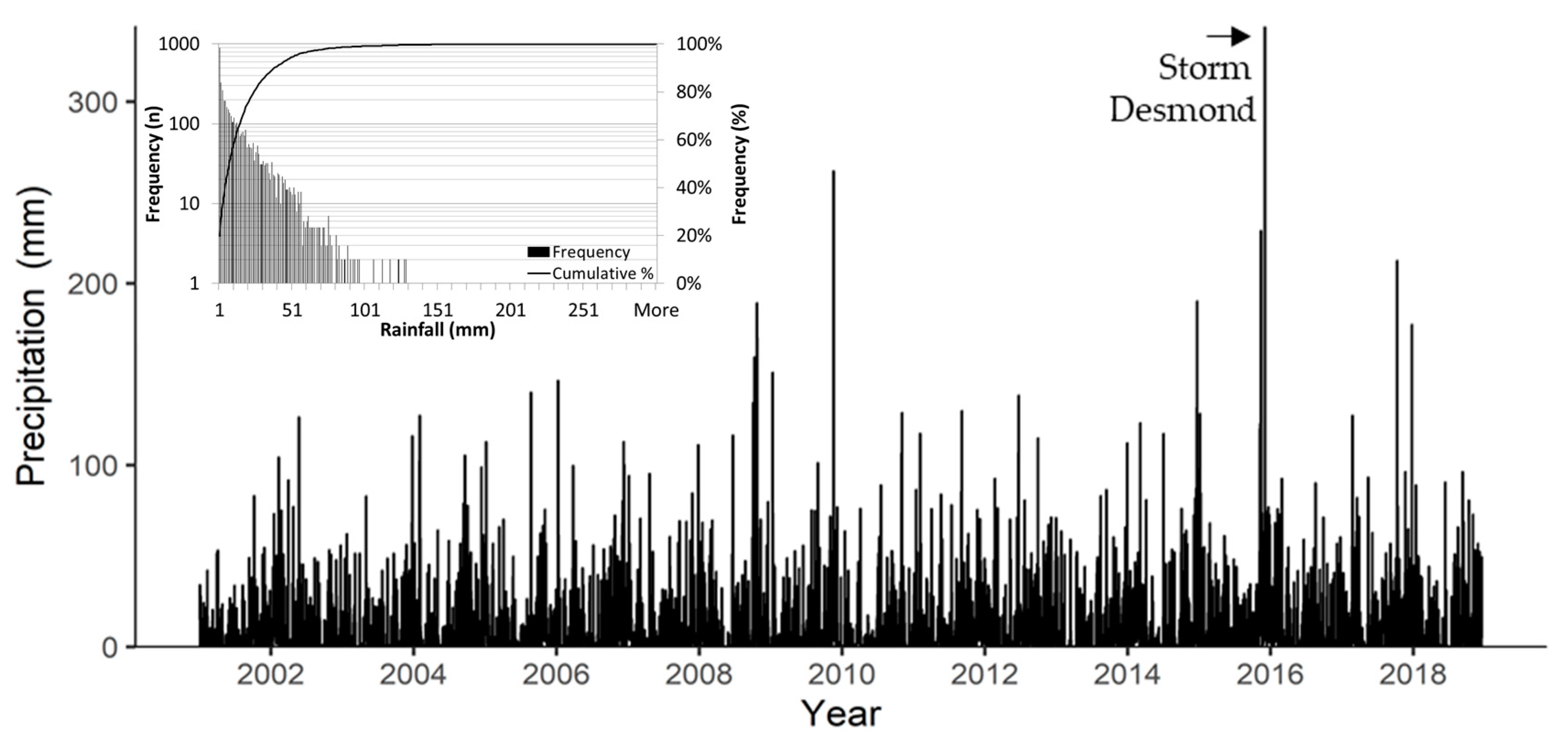
Lisa Beck is a small, ungauged, watercourse, however, the flooding in winter 2015/2016 was one of the most extraordinary hydrological episodes witnessed in the UK in recent decades [36] defined by a succession of severe storms, bringing extreme rainfall and associated widespread flooding. The upper catchment has a median daily rainfall of 7.6 mm, and a mean of 15 mm, the 84th percentile is 29 mm. An indication of the magnitude of the flood event can be gained from the rainfall record associated with Storm Desmond (Figure 3). The catchments of the Lake District were subjected to the second wettest November since records began in 1910 and the wettest ever December with the region receiving 3 times the monthly average [37], 341.4 mm of rainfall was recorded over 24 h at Honister Pass and 405 mm over 38 h at Thirlmere, both gauges are close to the Liza Beck study site (Figure 1). In Cumbria, Storm Desmond delivered enough rainfall to break the 24- and 48-h UK rainfall records. Its hydrological impacts were extreme, breaking recording the highest ever peak discharges [38]. The Centre for Ecology and Hydrology. [39] reported that the storm was the largest on record for Cumbria (1867–2017) and used the FEH13 rainfall frequency model [40] to estimate the return period at 1 in 1300 years.
2.2. Data Collection and Processing
2.2.1. Aerial Imagery and Historic Maps
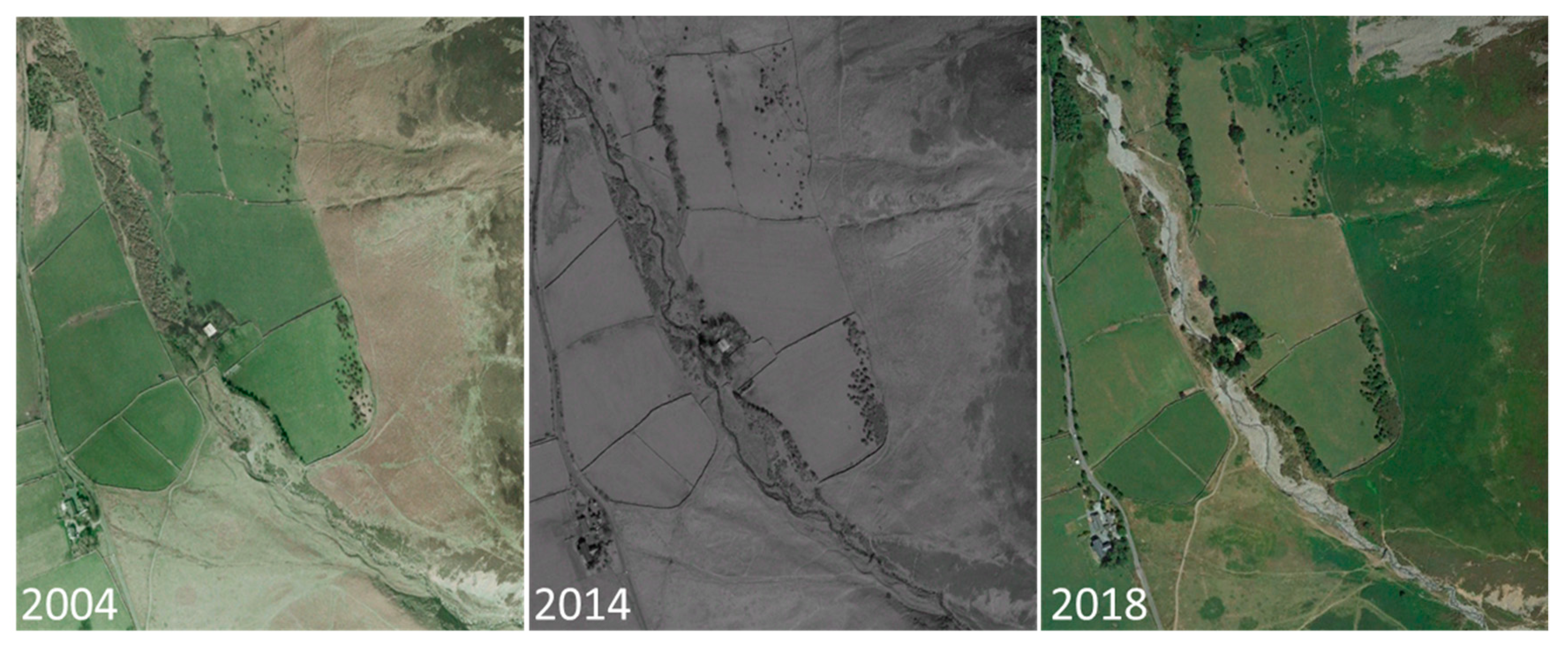
Historic maps were reviewed to reveal any historic gross change around Langthwaite. From these, it is clear that there has been no gross planform change since the first epoch Ordnance Survey mapping of the area (1860) although there is obvious straightening of the watercourse across the River Cocker Floodplain. Web-based aerial images from 2004, 2014, and 2018 were also interrogated for change (Figure 4) and these suggest some internal reworking of material at the bar unit scale.
2.2.2. Topographical Data
Topographic surveys have been conducted across the historically dynamic region of the river through Langthwaite Green in May 2017. A small unmanned aerial vehicle (sUAV) (DJi quadcopter) was used to obtain multiple aerial photographs of each study reach, using a high-resolution (20 Megapixels, at resolution 5472 × 3648 and 4K UHD video recording) narrow 3:2 aspect ratio, mounted on a remotely operated 3 axis gyroscopic gimble facilitating optimal picture quality. The camera was set to acquire photography at intervals of approximately 5 s in order to ensure sufficient spatial coverage and minimum 80% image overlap, following the principles of [34,35,40,41,42]. The camera settings were optimized for the survey conditions, these included: ISO levels, exposure compensation, and white balance. The sUAV was flown at low uniform height (~25 m AGL) to generate high resolution imagery (0.01 m) and accurate DTM reconstruction during post-processing (0.04 m). Images were principally captured at or near to nadir with oblique images focused around complex topography and vegetation. Coordinate georeferencing was facilitated through ground control points (GCPs) surveyed using a Leica system 500 dGPS. These GCPs were spaced roughly equidistant at 5 channel widths apart. Such a systematic distribution maximises their effectiveness in post-processing [35,41], enabling comparison to historic LiDAR.
All post-processing was conducted using Agisoft Structure from Motion (SfM) software on an Intel Xeon processor with 256GB RAM. Overlapping images were mosaicked together using an SfM photogrammetry approach [42] where rasterized three-dimensional representations are constructed from two-dimensional images [43]. Each individual image was manually inspected for quality, with any out-of-focus images discarded. Within each aerial image, GCPs were identified and assigned their corresponding dGPS-derived coordinate allowing the photographs to be realigned and scaled based on the OSGB-coordinate system. Through a moving window approach, an Agisoft generated point cloud is classified by an angle and distance from the lowest point filtering method. For Liza Beck, an angle of 8° and a max distance of 0.8 m was used as an initial iteration. Liza Beck vegetation was low shrub and Gorse, for trees and continuous canopies, a larger moving window cell size should be used, with a maximum angle of between 20 and 30 degrees and distance threshold at least below the bottom of the tree canopy. Each point within the UAV point cloud is assigned an RGB value, a supervised classification according to colour provides the second iteration to segregate ground points from vegetation due to the contrast in colour between flora surfaces and river gravels. A final manual iteration removes any isolated noise points that may persist. A textured model was then built using the geometry created from the classified point cloud providing a fully orthorectified aerial image of the study reach. Final model statistics are provided in Table 1.
2.2.3. Historic Lidar
Aerial Lidar data were obtained for the study site from the Environment Agency data archive for 2009 (1 m resolution). Reported vertical error on these data sets is 0.15 m. The data are georeferenced to the OSGB coordinate system.
2.2.4. Error Handling
When quantifying volumes of erosion and deposition Equation (1) was used to determine the combined error threshold hcrit for each of the three data sets
where σe1 and σe2 are the standard deviation of elevation error in the raw survey data, for each survey. The critical t value at the 95% confidence limit is ≥1.96 (2σ). Normally this procedure uses an average σe value for each surface, resulting in a uniform level of detection being applied to the DEM of difference [44]. The resultant threshold applied to the 2009–2017 data comparison was 0.1 m, and this was used to mask the surface difference data derived from consecutive surveys.
2.2.5. Surface roughness estimation
To further investigate the nature of change across along the study reach the DEM’s were used to generate local surface roughness statistics [44,45], allowing review of roughness element change as a proxy for changing sediment size. The standard deviation of elevation was calculated, setting a search radius greater than the largest stone within the study reach (see [46]).
3. Results
Change Evidence from Mapping and Imagery
Historic Ordnance Survey mapping of the reach extends back to 1860. The best map resolution was 1:10,000 scale and this failed to reveal any significant channel change across the site. As the river is not revetted along the study reach, it is suggesting that the large calibre fan material exposed in the channel banks is preventing the watercourse from migrating laterally.
Aerial imagery spans a shorter time-period with photographs available from 2004 and 2014, and the orthophoto developed from the 2018 drone survey (Figure 4). The images for 2004 and 2014 show no discernible change in the character of the watercourse. Between 2014 and 2018, however, there is a stripping of vegetation after the Beck discharges across Lanthwaite Green from the confined valley draining Brackenthwaite Fell. The stripping is, however, confined within the historic zone of channel activity as evidenced by the sharp slope breaks defining former erosive margins. Coarser erosive surfaces may be seen at the top of this reach with finer gravels visible across riparian margins further downstream.
The aerial imagery was also reviewed for the presence of palaeo-features potentially evidencing channel behaviour throughout the Holocene. It is clear that the current Liza Beck is cutting down into fan deposits disgorged from the narrow headwater valley further upstream. Fan lobes were not apparent, and it was difficult to identify palaeo-distributaries across the fan surface.
Warburton [28] stated that direct measurement of sediment transport in headwater systems is rare, and he goes on to demonstrate relative transport inefficiency of these systems, with high rates of erosion and sediment transport only seen at the local scale. The apparent rapid downstream deposition of eroded material on the Liza Beck certainly supports this conclusion. Subtraction of the January 2017 topographic survey from the 2009 Environment Agency LiDAR, the only historic data at 1 m resolution of the site (Table 2) reveals the gross sediment budget for the system. There were no extreme rainfall events during the period 2009–2015 with rainfall records consistently less than half of that recorded during Storm Desmond (Figure 3). As such, any change most strongly reflects the December 2015 extreme rainfall event in the catchment. Of interest is the relatively small imbalance in eroded and deposited sediment volumes with a net increase in storage of 1226.8 m3, which when averaged across the active channel zone through the study reach is the equivalent of 3.6 cm of accretion. This suggests the majority of delivered sediment is quickly deposited along the study reach with little overall export of bedload to the system downstream. It would appear that transport pathlengths are relatively short in response to this extreme flood, sediment balance and system functioning further downstream are thus likely to be controlled more by local sediment inputs rather than gross delivery from the upper catchment and habitat functioning in these areas appears unaffected by changes in the headwaters.
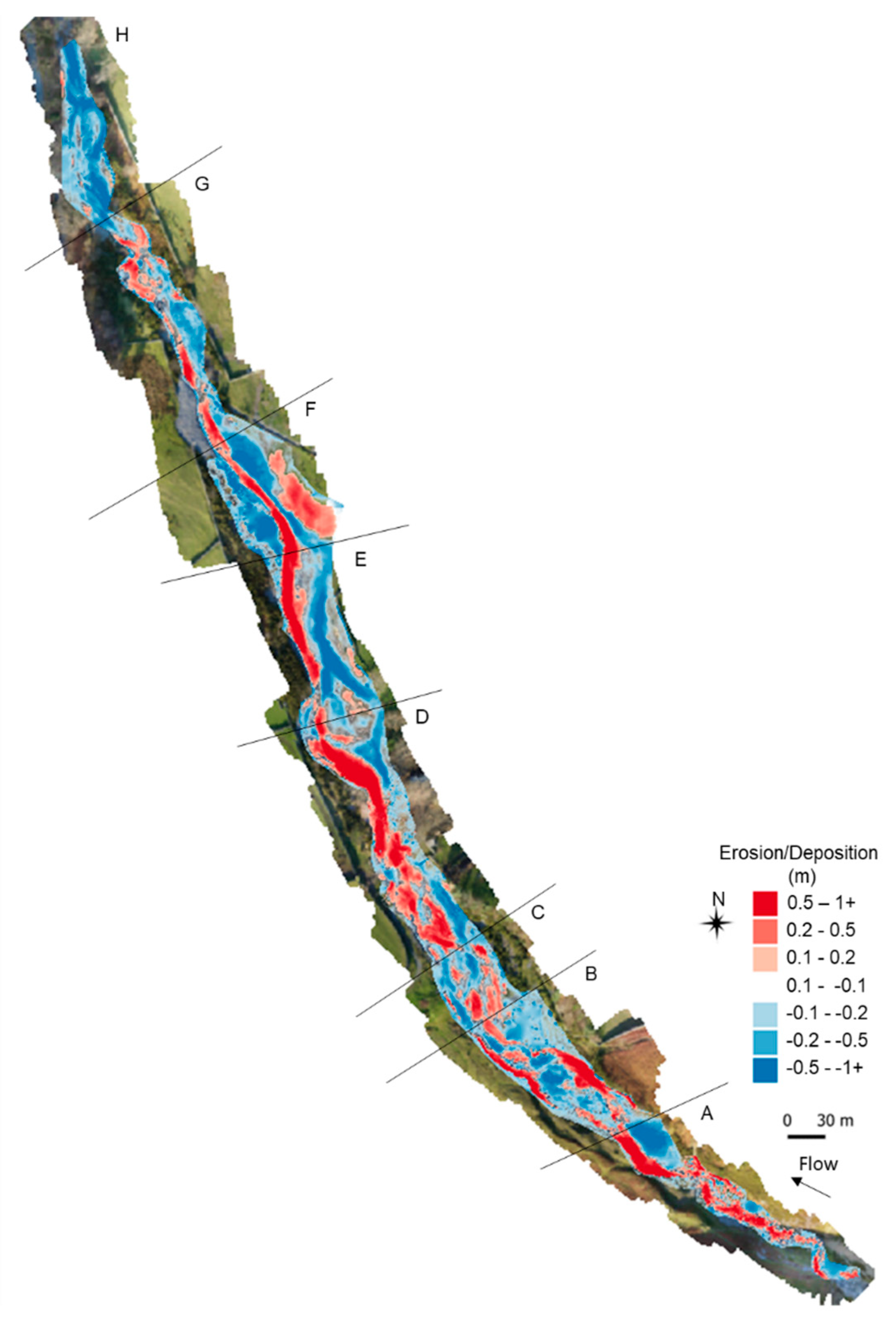
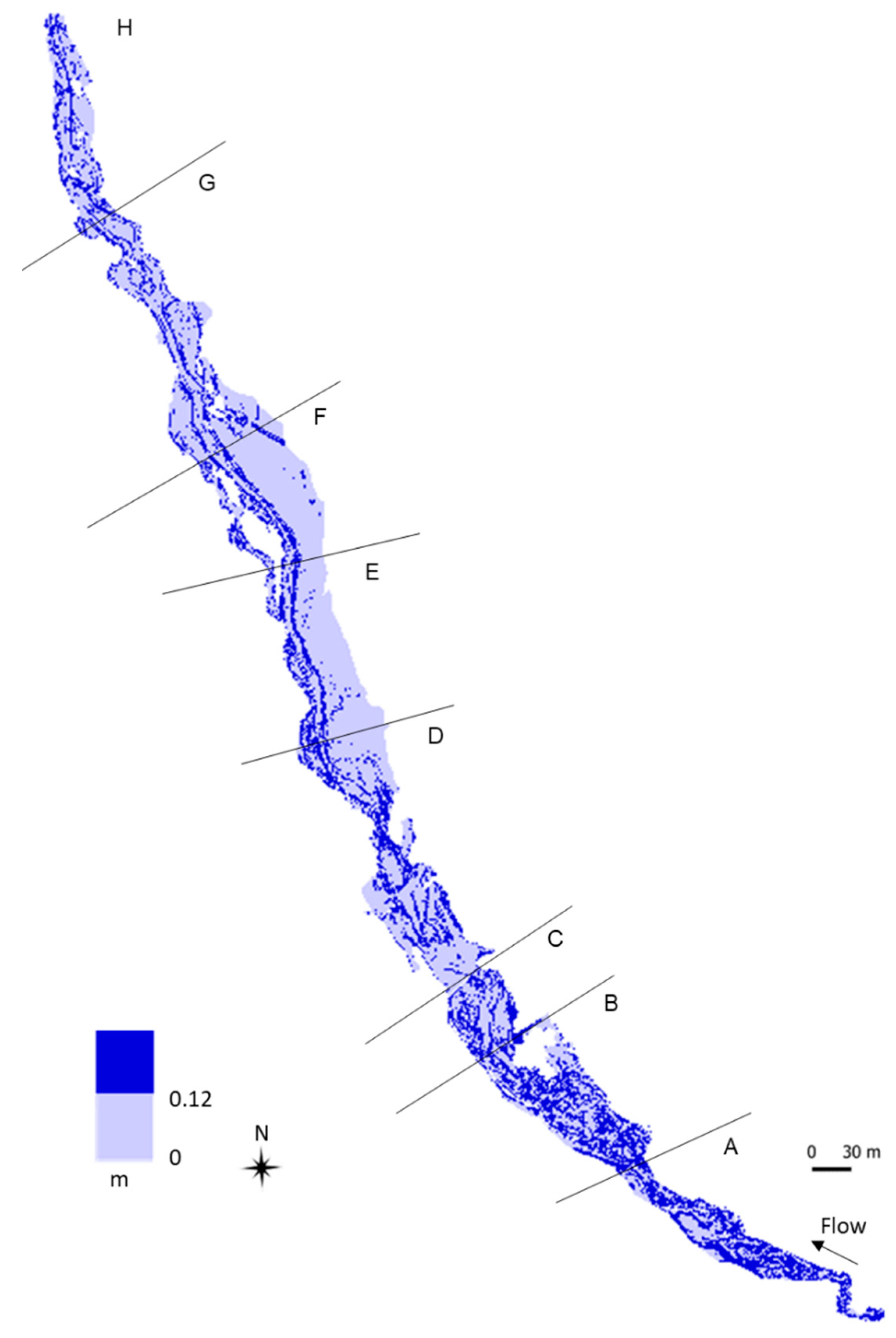
Figure 5 illustrates the variability in erosion and deposition along the reach between 2009 and 2017, principally reflecting the December 2015 extreme rainfall event in the catchment. The gross pattern appears to be one of erosion in the upper reaches and deposition further downstream, however, there is some local variability.
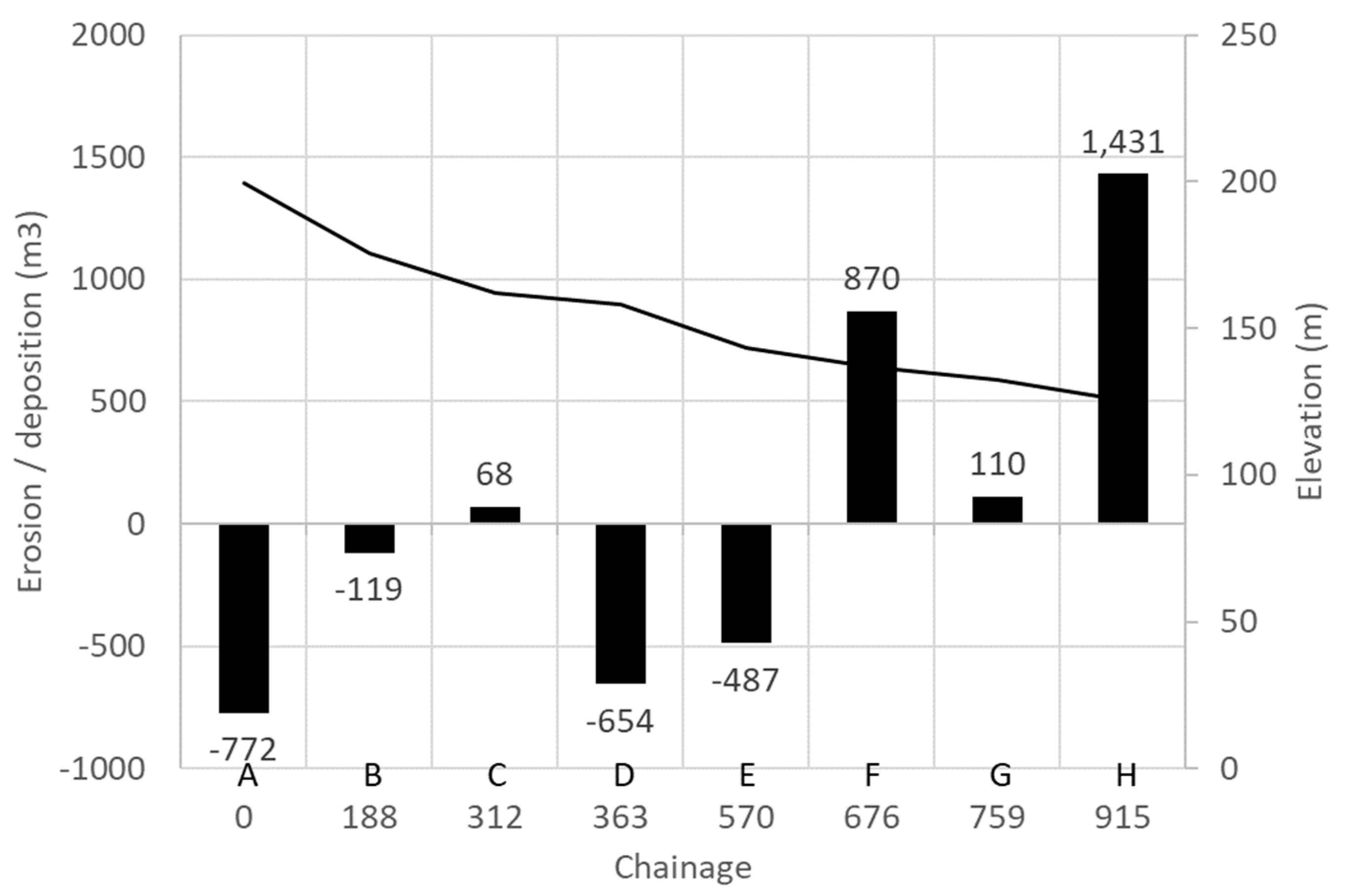
Local variation in overall sediment budgets has been attributed to changes in the sub-reach slope and active channel width and the pattern on Liza Beck was further investigated by visually dividing the river into eight sub-reaches consistent with the gross pattern of local erosion/deposition. The sub-reach volumetric change was then quantified (Figure 6). The pattern of overall erosion/deposition is revealed more clearly suggesting general loss through to sub-reach E and gain through to the end of the study reach but with minor overall sediment loss in sub-reach B and slight storage in sub-reach C.
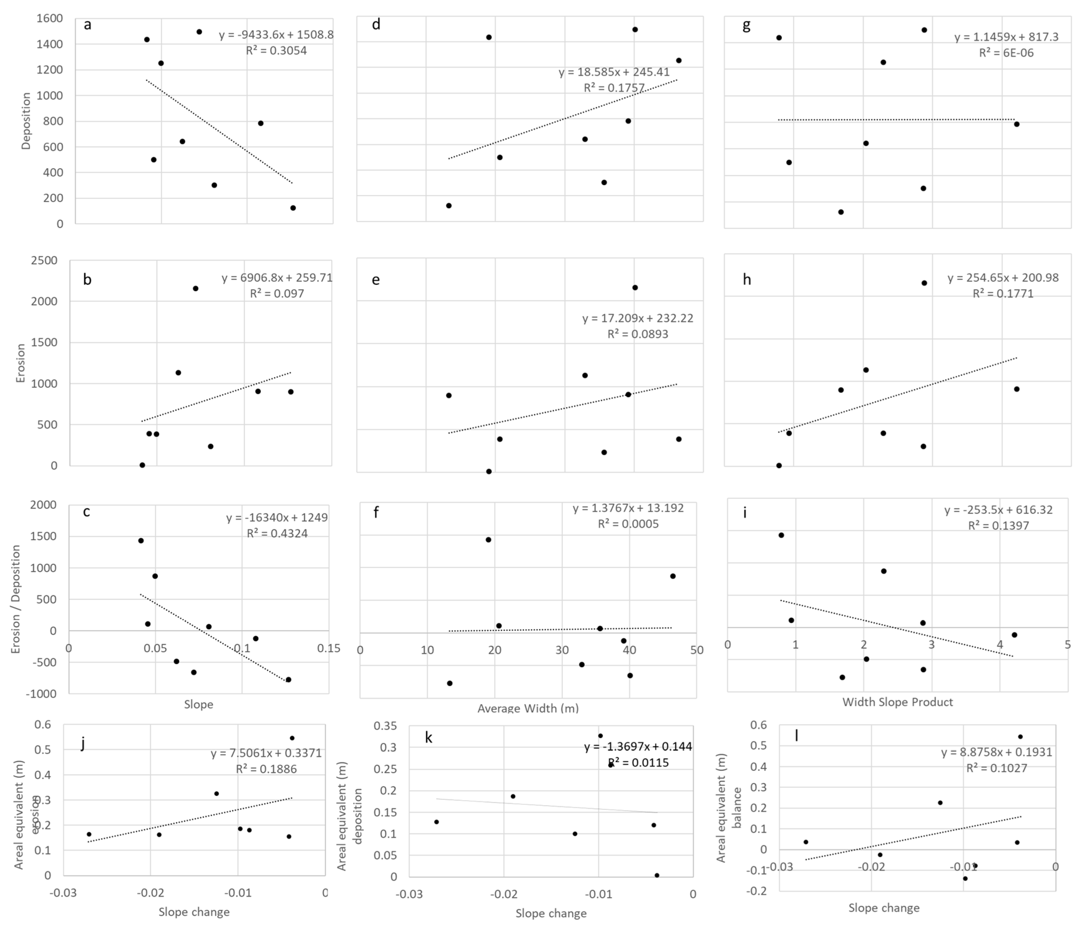
Sub-reach slopes were calculated following the low flow channel planform and average active channel confinement were determined by dividing the active channel area (derived from the DEM) by the sub-reach length. These parameters were plotted against gross average areal sediment loss, gain, and sediment balance (Figure 7). A weak relationship (r2 0.43) was seen between slope and sediment balance (Figure 7c), no relationship was seen between these parameters and width or width-slope product (Figure 7d–i). The relationship between slope and sediment flux was examined further plotting average areal erosion, deposition, and sediment balance against local slope change (downstream–upstream), no significant relationship was found (Figure 7j–l).
These results suggest that local channel slope exerts the greatest influence on bedload dynamics with lower slopes accumulating more material, confinement and abrupt local slope change were not influential. The general poor correlation between sub-reach sediment change and channel geometry change suggests, however, that other factors are having a greater influence on bedload dynamics. Cut and fill activity occurring as a result of local avulsion processes in the low flow channel network (Figure 5) appears important here with localised severe erosion of current sub-channels in sub-reach A and significant sub-channel creation through erosion in sub-reaches B–E. The comparatively severe loss of sediment from these upper reaches is moderated in sub-reaches B and C by sedimentation across inset bar and berm areas (Figure 5). Infilling of sub-channels following channel switching in sub-reach E. These local morphological changes contrast strongly with the significant reduction in new channel cutting seen in sub-reaches E and F, and high levels of deposition outside of the active low-flow channels but still within the inset river in sub-reaches E–H. These patterns suggest upstream active channel incision, mid-reach channel cut, and fill activity and downstream overbank deposition is occurring, and it is likely that sediment eroded from the upper reaches is being quickly deposited downstream.
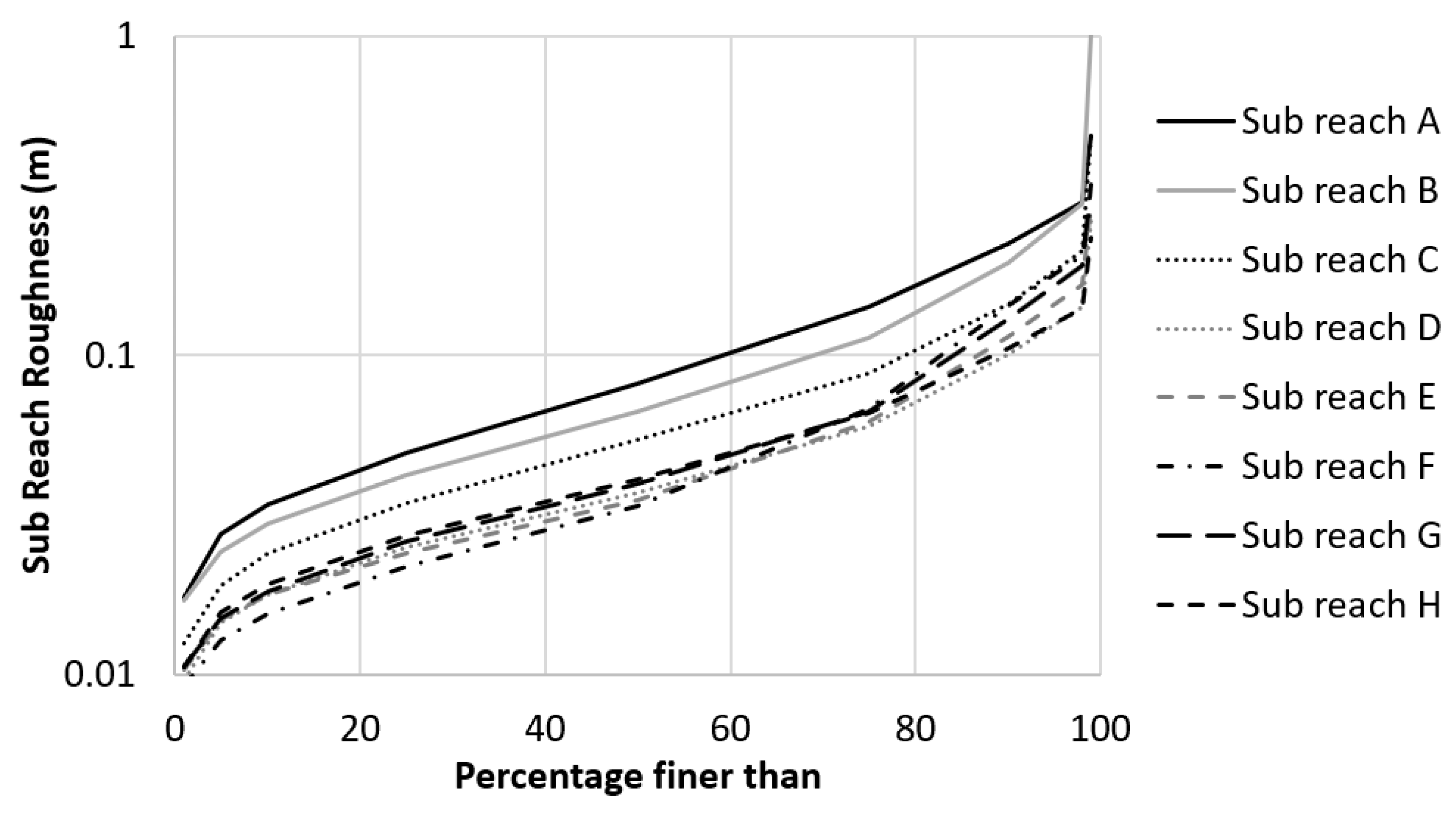
The gross pattern of upstream erosion and downstream deposition has also been correlated with a change in channel roughness [47] reflecting rapid downslope and lateral sediment fining (Figure 8) with coarser sediments remaining exposed upstream and along active sub-channels and finer sediment seen more generally across channel and overbank areas downstream where gravel sheet deposits are present reflecting deposition associated with rapid flow energy reduction as flows shallow and spread away from the active channels. This is also clear across the Liza Beck study reach when the sub-reach surface roughness is characterised, sub-reaches A–C exhibit a coarser sediment distribution compared to the downstream sub-reaches (F–H) (Figure 9). Sub-reaches D and E are transitional crossing the finer frequency distributions downstream due to the presence of a less coarse fine fraction and a bigger calibre coarse fraction.
With regard to morphologic units, new active channels are characteristically coarser than surrounding berm and bar deposits, and channel infills appear similar to the general berm/bar surface deposits. No significant deposition of coarse material occurred beyond the inset channel margin.
4. Discussion
The lack of channel movement on the Liza Beck, as evidenced from historic mapping, suggests that the planform of the channel is effectively fixed under the current flow regime with flood flow forces insufficient to erode and mobilise the larger clasts present in the palaeo-fan deposit through which the river is flowing. Attempts by the channel to avulse and activate a different part of the fan is being prevented by active management.
The overall coarse sediment budget for the Liza Beck study reach principally in response to the extreme flood generated by Storm Desmond in December 2015 was quantified as a net deposition of 1227 m3 of coarse sediment. This suggests that the present flood regime is generally incompetent to deliver significant volumes of coarse sediment to the system downstream. This is consistent with the earlier study of Johnson and Warburton [31] who found that the fan channel on the Iron Crag torrent system in the English Lake District stored the majority of the 184 tonnes of coarse sediment supplied over a year. They recorded the greatest deposition of material across the fan of Iron Crag following storm events with depositional volumes closely matching the erosion to the channel bed and banks measured upstream. Data has also been published from St John’s Beck, Cumbria, in response to the extreme Storm Desmond flood event. Field measurements show 6500 ± 710 tonnes of sediment was eroded or scoured from the river floodplains, banks and bed during the event, with 6300 ± 570 tonnes of sediment deposited in the channel or on the surrounding floodplains. Only 6% of sediment eroded during the flood event was transported out of the 8 km channel study reach [30]. The authors argue from these data that current flood processes on St John’s Beck are acting to suppress downstream sediment transfer. They also identified overbank floodplain sediment deposits as the dominant new feature in the landscape on St John’s Beck, storing 72% of the eroded sediment. Data from the Liza Beck sub-reach budgeting also suggests that this system is suppressing downstream coarse bedload transfer with erosion at the top of the reach quickly giving way to widespread local deposition downstream. Here, however, deposition is confined within the active inset channel rather than splaying across floodplain areas. The deposition was also recorded along channels abandoned during the flood following local avulsion and this material remains more susceptible to re-erosion during future flood events causing the low flow channel network to flip between relatively fixed sub-channels present across the active channel belt.
Analysis of the influence of slope and confidence on sediment transport suggests only a weak positive relationship with slope, contradicting the results of Nagel et al, [48]. Further research is ongoing into modelling the effect of local flood flow changes on sediment transport. The gross incompetence of the system to transport boulders is suggested by the distribution of roughness across the study area. Areas of erosion appear to be associated with a roughening of the bed until the sediment size exceeds the flood competence of the watercourse. In contrast, deposition areas are markedly less rough suggesting a surface composed of finer sediment and it is this material that formed the mobile bedload in floods. Some material of this calibre may be released as a result of erosion of past channel infill deposits, but these alone are of insufficient volume at Liza Beck study reach to account for all of the deposition measured further downstream. By inference, this gravel bedload must be being supplied from the confined reach upstream of the fan where the watercourse was observed to be eroding into valley side till deposits in several places.
Overall these results suggest a contemporary extreme flood bedload transport regime dominated by gravelly material across a largely invariant very coarse surface of ancient fan deposits. Sediment movement in this headwater zone is thus seen to be restricted generally to phase I transport. Other studies concur with this finding, concluding that complete bed disruption is rare, Reid et al [49] suggest Phase II transport (sensu [50]) may be comparatively short, occurring only during parts of larger flood events with UK upland rivers experiencing only very infrequent movement of coarse bed material (where the D16 is cobble sized and above).
Despite mobilising large volumes of coarse bed sediment, the planform of the Liza Beck remained confined to an active inset channel zone two to three times the low flow channel width with relatively limited bank erosion. Kienholz et al. [51] found similar from their study of Swiss torrents where 60% of the sediment moved was sourced from the channel with the banks contributing 23%. Where lateral erosion was recorded in the Liza Beck, it appears to have mobilised finer sediment before halting when coarser ancient material was encountered, Hatfield and Maher [11] similarly concluded that finer sediment production is linked strongly to local supply zones across valley bottom sediments.
5. Conclusions
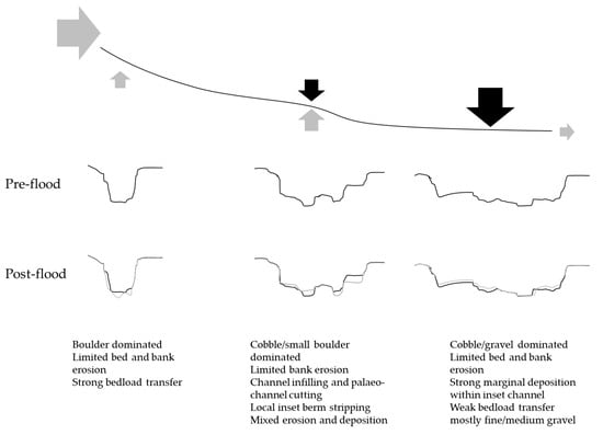
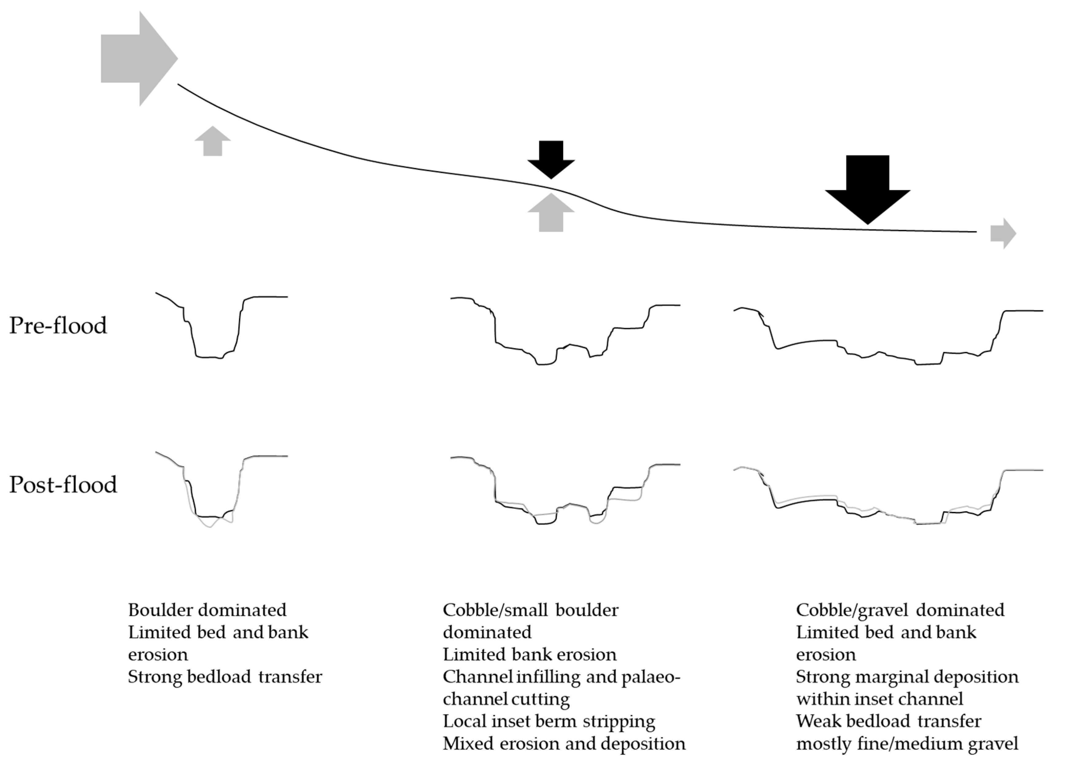
Patterns of system change and the processes driving change are the focus of much international geomorphological research. Flood magnitude and frequency are seen as key drivers with regard to triggering change on fluvial systems, coupled with the degree of sediment coupling. Meade [52] developed an idealised model of sediment residence time with storage duration increasing downstream as transient bar features give way to more permanent floodplain alluvium. This conceptual understanding is revisited in the light of the research on Liza Beck, Figure 11 is a model of torrent channel response to extreme floods derived from this study. It suggests that:
- Extreme response is moderated by the current competence of flood flows to mobilise larger sediment which remains as a relic of more energetic post-glacial conditions.
- Fine sediment stripping down to the remnant post-glacial sediment expands the flood channel to create erosive coarse sediment units.
- Lateral change is restricted, again linked to an inability to erode large calibre bank sediment.
- Channel movement within the active belt width is primarily through sub-channel creation, these appear to follow palaeo-routes, stripping out smaller calibre sediment.
- Abandoned channels become filled with smaller calibre flood sediment.
- Local channel slope exerted a weak influence on deposition whilst width change did not impact on bedload transport.
- Released finer bedload (mostly gravels) are rapidly re-deposited across inset channel berms and bars downstream.
- Relatively little coarse sediment is exported from the channel.
Overall the survey approach used in this paper demonstrates the value of drone-based orthophotography and DEM surfaces with rapid cost-effective data capture and processing allowing change to be elucidated from the grain to the reach scale.
Author Contributions
G.H. and N.E. equally contributed to the production of this research paper.
Funding
This research received no external funding.
Acknowledgments
The authors would like to thank the Environment Agency for access to rainfall data and lidar. We would also like to thank the National Trust for access to the field site, and the anonymous three reviewers who helped to improve the manuscript.
Conflicts of Interest
The authors declare no conflict of interest.
References
- Korup, O. Earth’s portfolio of extreme sediment transport events. Earth Sci. Rev. 2012, 112, 115–125. [Google Scholar] [CrossRef]
- Wicherski, W.; Dethier, D.P.; Ouimet, W.B. Erosion and channel changes due to extreme flooding in the Fourmile Creek catchment, Colorado. Geomorphology 2017, 294, 87–98. [Google Scholar] [CrossRef]
- Prosser, I.P.; Hughes, A.O.; Rutherfurd, I.D. Bank erosion of an incised upland channel by subaerial processes: Tasmania, Australia. Earth Surface Processes and Landforms. J. Br. Geomorphol. Res. Group 2000, 25, 1085–1101. [Google Scholar]
- Milan, D.J. Geomorphic impact and system recovery following an extreme flood in an upland stream: Thinhope Burn, northern England, UK. Geomorphology 2012, 138, 319–328. [Google Scholar] [CrossRef]
- Thompson, C.; Croke, J. Geomorphic effects, flood power and channel competence of a catastrophic flood in confined and unconfined reaches of the upper Lockyer valley, southeast Queensland, Australia. Geomorphology 2013, 197, 156–169. [Google Scholar] [CrossRef]
- Krapesch, G.; Hauer, C.; Habersack, H. Scale orientated analysis of river width changes due to extreme flood hazards. Nat. Hazards Earth Syst. Sci. 2011, 11, 2137–2147. [Google Scholar] [CrossRef]
- Williams, G.P.; Costa, J.E. Geomorphic Measurements After a Flood. Flood Geomorphology; John Wiley & Sons: New York, NY, USA, 1988; pp. 65–77. [Google Scholar]
- Knox, J.C. Floodplain sedimentation in the Upper Mississippi Valley: Natural versus human accelerated. Geomorphology 2006, 79, 286–310. [Google Scholar] [CrossRef]
- Magilligan, F.J. Thresholds and the spatial variability of flood power during extreme floods. Geomorphology 1992, 5, 373–390. [Google Scholar] [CrossRef]
- Holliday, V.J.; Warburton, J.J.; Higgitt, D.L. Historic and contemporary sediment transfer in an upland Pennine catchment, UK. Earth Surf. Process. Landf. 2008, 33, 2139–2155. [Google Scholar] [CrossRef]
- Hatfield, R.G.; Maher, B.A. Fingerprinting upland sediment sources: Particle size-specific magnetic linkages between soils, lake sediments and suspended sediments. Earth Surf. Process. Landf. 2009, 34, 1359–1373. [Google Scholar] [CrossRef]
- Bracken, L.J.; Turnbull, L.; Wainwright, J.; Bogaart, P. Sediment connectivity: A framework for understanding sediment transfer at multiple scales. Earth Surf. Process. Landf. 2015, 40, 177–188. [Google Scholar] [CrossRef]
- Warburton, J. Sediment budgets and rates of sediment transfer across cold environments in Europe: A commentary. Geogr. Ann. Ser. A Phys. Geogr. 2007, 89, 95–101. [Google Scholar] [CrossRef]
- Church, M.; Hassan, M.A. Mobility of bed material in Harris Creek. Water Resour. Res. 2002, 38, 19-1–19-21. [Google Scholar] [CrossRef]
- Carling, P.A. The Noon Hill flash floods; July 17th 1983. Hydrological and geomorphological aspects of a major formative event in an upland landscape. Trans. Inst. Br. Geogr. 1986, 11, 105–118. [Google Scholar] [CrossRef]
- McEwen, L.J.; Werritty, A. The hydrology and long- term geomorphic significance of a flash flood in the Cairn- gorm Mountains, Scotland. Catena 1988, 15, 361–377. [Google Scholar] [CrossRef]
- Harvey, A.M. Differential recovery from the effects of a 100-year storm: Significance of long-term hillslope–channel coupling; Howgill Fells, northwest England. Geomorphology 2007, 84, 192–208. [Google Scholar] [CrossRef]
- Wells, S.G.; Harvey, A.M. Sedimentologic and geomorphic variations in storm-generated alluvial fans, Howgill Fells, northwest England. Geol. Soc. Am. Bull. 1987, 98, 182–198. [Google Scholar] [CrossRef]
- Harvey, A.M. Coupling between hillslopes and channels in upland fluvial systems: Implications for landscape sensitivity, illustrated from the Howgill Fells, northwest England. Catena 2001, 42, 225–250. [Google Scholar] [CrossRef]
- Fryirs, K.A.; Brierley, G.J.; Preston, N.J.; Kasai, M. Buffers, barriers and blankets: The (dis) connectivity of catchment-scale sediment cascades. Catena 2007, 70, 49–67. [Google Scholar] [CrossRef]
- Carling, P.A.; Reader, N.A. Structure, composition and bulk properties of upland stream gravels. Earth Surf. Process. Landf. 1982, 7, 349–365. [Google Scholar] [CrossRef]
- Parker, G.; Klingeman, P.C.; McLean, D.G. Bedload and size distribution in paved gravel-bed streams. J. Hydraul. Div. 1982, 108, 544–571. [Google Scholar]
- Gomez, B. Temporal variations in bedload transport rates: The effect of progressive bed armouring. Earth Surf. Process. Landf. 1983, 8, 41–54. [Google Scholar] [CrossRef]
- Brayshaw, A.C.; Frostick, L.E.; Reid, I.A.N. The hydrodynamics of particle clusters and sediment entrapment in coarse alluvial channels. Sedimentology 1983, 30, 137–143. [Google Scholar] [CrossRef]
- Andrews, E.D.; Erman, D.C. Persistence in the size distribution of surficial bed material during an extreme snowmelt flood. Water Resour. Res. 1986, 22, 191–197. [Google Scholar] [CrossRef]
- Church, M.A.; McLean, D.G.; Wolcott, J.F. River bed gravels: Sampling and Analysis, in Sediment Transport in Gravel-Bed Rivers; Thorne, C.R., Bathurst, J.C., Hey, R.D., Eds.; John Wiley: New York, NY, USA, 1987; pp. 43–79. [Google Scholar]
- Trimble, S.W. Streams, valleys and floodplains in the sediment cascade. In Sediment Cascades: An Integrated Approach; Burt, T., Allison, R.J., Eds.; John Wiley and Sons: Chichester, UK, 2010; pp. 307–343. [Google Scholar]
- Warburton, J. Sediment transfer in steep upland catchments (Northern England, UK): Landform and sediment source coupling. In Landform-Structur, Evolution, Process Control; Springer: Berlin/Heidelberg, Germany, 2009; pp. 165–183. [Google Scholar]
- Warburton, J.; Kincey, M.; Johnson, R.M. Assessment of Torrent Erosion Impacts on the Eastern Flank of Thirlmere Reservoir and A591 (Cumbria) Following Storm Desmond 2015; United Utilities: Warrington, UK, 2015. [Google Scholar]
- Joyce, H.M.; Hardy, R.J.; Warburton, J.; Large, A.R. Sediment continuity through the upland sediment cascade: Geomorphic response of an upland river to an extreme flood event. Geomorphology 2018, 317, 45–61. [Google Scholar] [CrossRef]
- Johnson, R.M.; Warburton, J. Annual sediment budget of a UK mountain torrent. Geogr. Ann. Ser. A Phys. Geogr. 2002, 84, 73–88. [Google Scholar] [CrossRef]
- Entwistle, N.; Heritage, G.; Milan, D. Recent remote sensing applications for hydro and morphodynamic monitoring and modelling. Earth Surf. Process. Landf. 2018, 43, 2283–2291. [Google Scholar] [CrossRef]
- Tomsett, C.; Leyland, J. Remote sensing of river corridors: A review of current trends and future directions. River Res. Appl. 2019. [Google Scholar] [CrossRef]
- Entwistle, N.S.; Heritage, G. An evaluation DEM accuracy acquired using a small unmanned aerial vehicle across a riverine environment. Int. J. New Technol. Res. 2017, 3, 43–48. [Google Scholar]
- Entwistle, N.S.; Heritage, G.L. Small unmanned aerial model accuracy for photogrammetrical fluvial bathymetric survey. J. Appl. Remote. Sens. 2019, 13, 014523. [Google Scholar] [CrossRef]
- Matthews, T.; Murphy, C.; McCarthy, G.; Broderick, C.; Wilby, R.L. Super Storm Desmond: A process-based assessment. Environ. Res. Lett. 2018, 13, 014024. [Google Scholar] [CrossRef]
- McCarthy, M.; Spillane, S.; Walsh, S.; Kendon, M. The meteorology of the exceptional winter of 2015/2016 across the UK and Ireland. Weather 2016, 71, 305–313. [Google Scholar] [CrossRef]
- Barker, L.; Hannaford, J.; Muchan, K.; Turner, S.; Parry, S. The winter 2015/2016 floods in the UK: A hydrological appraisal. Weather 2016, 71, 324–333. [Google Scholar] [CrossRef]
- CEH. North West Floods—Hydrological Update. 2015. Available online: https://www.ceh.ac.uk/news-and1168 media/blogs/north-west-floods-hydrological-update (accessed on 28 June 2019).
- Stewart, L.; Vesuviano, G.; Morris, D.; Prosdocimi, I. The new FEH rainfall depth-duration-frequency model: Results, comparisons and implications. In Proceedings of the 12th British Hydrological Society National Symposium, Birmingham, UK, 2–4 September 2014. [Google Scholar]
- Tonkin, T.; Midgley, N. Ground-control networks for image based surface reconstruction: An investigation of optimum survey designs using UAV derived imagery and structure-from-motion photogrammetry. Remote Sens. 2016, 8, 786. [Google Scholar] [CrossRef]
- Micheletti, N.; Chandler, J.H.; Lane, S.N. Structure from motion (SFM) photogrammetry. In Geomorphological Techniques, Online Edition; Clarke, L.E., Nield, J.M., Eds.; British Society for Geomorphology: London, UK, 2019; Chapter 2, Section 2.2; ISSN 2047-0371. [Google Scholar]
- Scaramuzza, D.; Martinelli, A.; Siegwart, R. A flexible technique for accurate omnidirectional camera calibration and structure from motion. In Proceedings of the 4th IEEE International Conference on Computer Vision Systems (ICVS’06), New York, NY, USA, 4–7 January 2006; p. 45. [Google Scholar]
- Milan, D.J.; Heritage, G.L.; Large, A.R.; Fuller, I.C. Filtering spatial error from DEMs: Implications for morphological change estimation. Geomorphology 2011, 125, 160–171. [Google Scholar] [CrossRef]
- Brasington, J.; Vericat, D.; Rychkov, I. Modeling river bed morphology, roughness, and surface sedimentology using high resolution terrestrial laser scanning. Water Resour. Res. 2012, 48, 11519. [Google Scholar] [CrossRef]
- Gomez, B. Roughness of stable, armored gravel beds. Water Resour. Res. 1993, 29, 3631–3642. [Google Scholar] [CrossRef]
- Pearson, E.; Smith, M.W.; Klaar, M.J.; Brown, L.E. Can high resolution 3D topographic surveys provide reliable grain size estimates in gravel bed rivers? Geomorphology 2017, 293, 143–155. [Google Scholar] [CrossRef]
- Nagel, D.E.; Buffington, J.M.; Parkes, S.L.; Wenger, S.; Goode, J.R. A landscape scale valley confinement algorithm: Delineating unconfined valley bottoms for geomorphic, aquatic and riparian applications. RMRS-GTR-321. Fort Collins, CO: US Department of Agriculture, Forest Service, Rocky Mountain Research Station. Gen. Tech. Rep. 2014, 42, 321. [Google Scholar]
- Reid, S.C.; Lane, S.N.; Berney, J.M.; Holden, J. The timing and magnitude of coarse sediment transport events within an upland, temperate gravel-bed river. Geomorphology 2007, 83, 152–182. [Google Scholar] [CrossRef]
- Jackson, W.L.; Beschta, R.L. A model of two-phase bedload transport in an Oregon Coast Range stream. Earth Surf. Process. Landf. 1982, 7, 517–527. [Google Scholar] [CrossRef]
- Keinholz, H.; Lehmann, C.; Guggisberg, C.; Loat, R.; Hegg, C. Bedload budget in Swiss Mountain torrents with respect to the disaster in 1987. Z. Fur. Geomorphol. 1991, 983, 53–62. [Google Scholar]
- Meade, R.H. Sources, sinks and storage of river sediment in the Atlantic drainage of the United States. J. Geol. 1982, 90, 235–252. [Google Scholar] [CrossRef]
Figure 1.
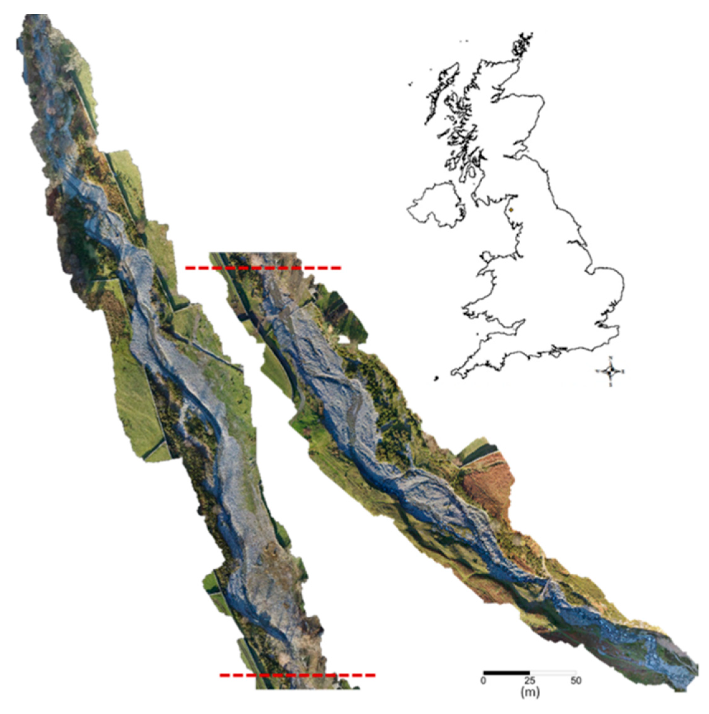
The Liza Beck study site, Cumbria, UK. Latitude 54.577317°, Longitude −3.298623°.

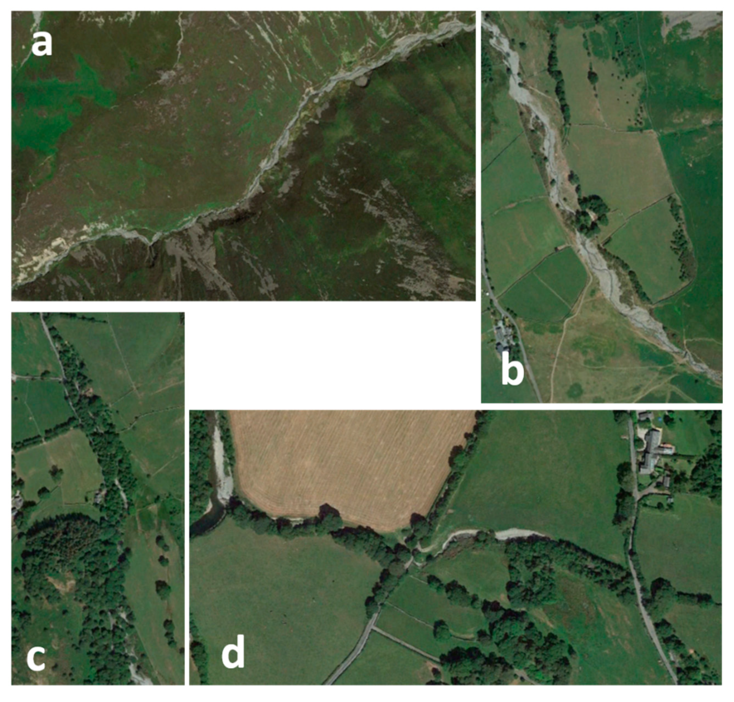
Figure 2.
Changing character of Liza Beck, (a) bedrock/boulder cascade, (b) boulder dominated torrent, (c) single-thread/bifurcated, (d) historically straightened single-thread.
Figure 2.
Changing character of Liza Beck, (a) bedrock/boulder cascade, (b) boulder dominated torrent, (c) single-thread/bifurcated, (d) historically straightened single-thread.

Figure 3.
Rainfall record for Honister Pass, Cumbria including the Storm Desmond extreme event December 2015, inset.
Figure 3.
Rainfall record for Honister Pass, Cumbria including the Storm Desmond extreme event December 2015, inset.

Figure 4.
Historic image mapping of the Liza Beck at Langthwaite, Cumbria, UK. Original image resolution 2004 0.6 m (Source Google Earth), 2014 0.5 m (Source Google Earth), 2018 0.02 m.
Figure 4.
Historic image mapping of the Liza Beck at Langthwaite, Cumbria, UK. Original image resolution 2004 0.6 m (Source Google Earth), 2014 0.5 m (Source Google Earth), 2018 0.02 m.

Figure 5.
Erosion and deposition pattern recorded along Liza Beck between 2009 and 2017 most strongly reflecting the December 2015 extreme rainfall event in the catchment.
Figure 5.
Erosion and deposition pattern recorded along Liza Beck between 2009 and 2017 most strongly reflecting the December 2015 extreme rainfall event in the catchment.

Figure 6.
Sub-reach coarse sediment balance (2009–2017) recorded along Liza Beck in relation to local gradient reduction downstream.
Figure 6.
Sub-reach coarse sediment balance (2009–2017) recorded along Liza Beck in relation to local gradient reduction downstream.

Figure 7.
Slope and channel constriction, erosion and deposition recorded along Liza Beck between 2009 and 2017.
Figure 7.
Slope and channel constriction, erosion and deposition recorded along Liza Beck between 2009 and 2017.

Figure 8.
Downstream change in micro-surface roughness.

Figure 9.
Downstream change in micro-surface roughness.

Figure 10.
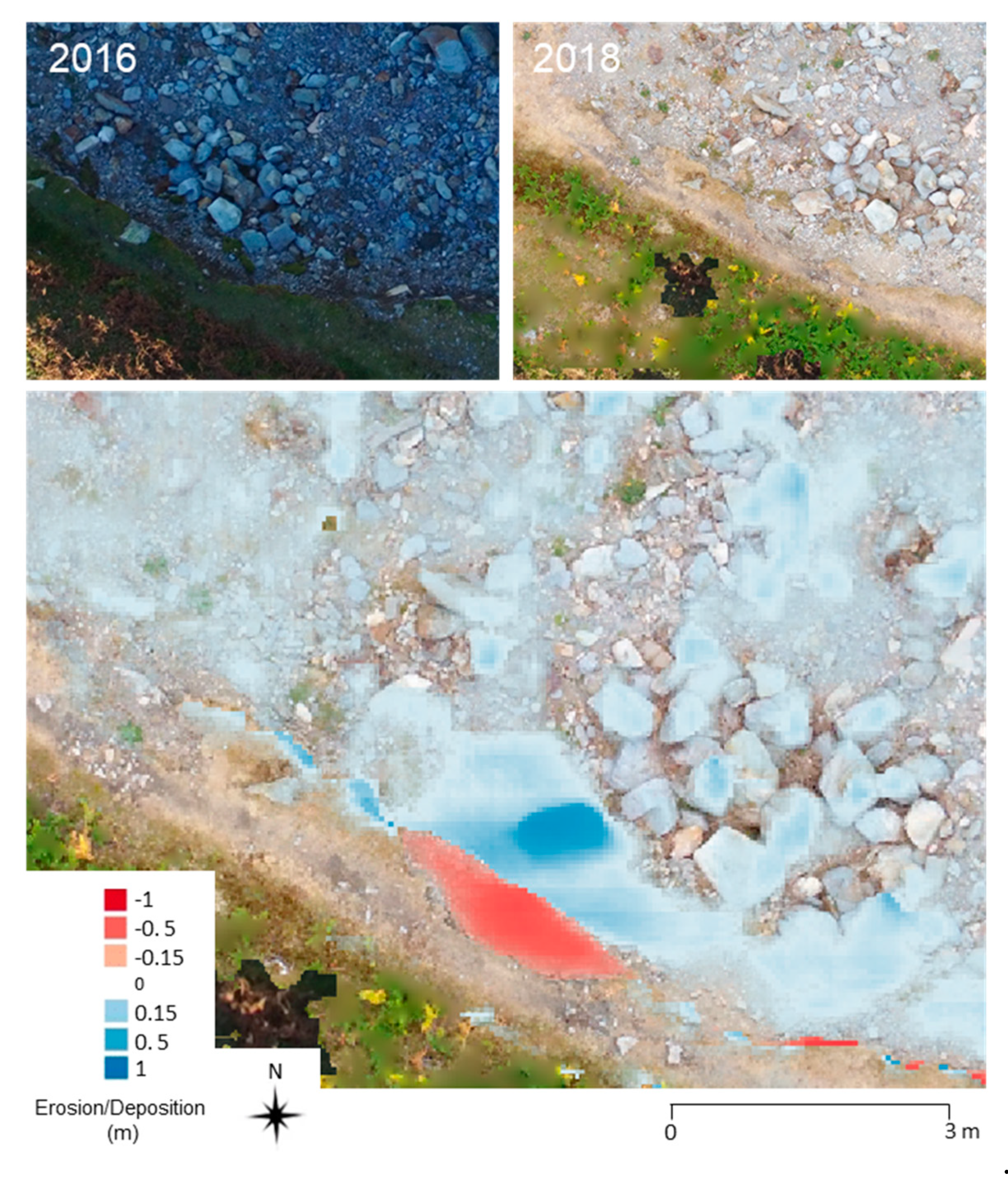
Newly exposed coarse sediment along stripped channel margins on the Liza Beck at Langthwaite.
Figure 10.
Newly exposed coarse sediment along stripped channel margins on the Liza Beck at Langthwaite.

Figure 11.
A model of torrent channel response to a contemporary temperate climate flood regime.


Table 1.
Model statistics for small unmanned aerial vehicle surveys of Liza Beck.
| Survey | Number of Images | DTM Resolution (m) | Ortho Resolution (m) | X Error (m) | Y Error (m) | Z Error (m) | Combined Error (m) |
|---|---|---|---|---|---|---|---|
| UAV survey 1 | 467 | 0.04 | 0.01 | 0.014 | 0.025 | 0.007 | 0.030 |
| UAV survey 2 | 530 | 0.04 | 0.01 | 0.017 | 0.014 | 0.021 | 0.037 |
Table 2.
Reach extreme event gross sediment budget for the Liza Beck at Langthwaite.
| River | Volume Deposited (m3) | Volume Eroded (m3) | Volume Balance (m3) | Areal Equivalent (m) |
|---|---|---|---|---|
| Liza Beck at Langthwaite | 6404.3 | 5177.5 | 1226.8 | 0.036 |
© 2019 by the authors. Licensee MDPI, Basel, Switzerland. This article is an open access article distributed under the terms and conditions of the Creative Commons Attribution (CC BY) license (http://creativecommons.org/licenses/by/4.0/).
Share and Cite
MDPI and ACS Style
Heritage, G.; Entwistle, N. Drone Based Quantification of Channel Response to an Extreme Flood for a Piedmont Stream. Remote Sens. 2019, 11, 2031. https://0-doi-org.brum.beds.ac.uk/10.3390/rs11172031
AMA Style
Heritage G, Entwistle N. Drone Based Quantification of Channel Response to an Extreme Flood for a Piedmont Stream. Remote Sensing. 2019; 11(17):2031. https://0-doi-org.brum.beds.ac.uk/10.3390/rs11172031
Chicago/Turabian StyleHeritage, George, and Neil Entwistle. 2019. "Drone Based Quantification of Channel Response to an Extreme Flood for a Piedmont Stream" Remote Sensing 11, no. 17: 2031. https://0-doi-org.brum.beds.ac.uk/10.3390/rs11172031
Note that from the first issue of 2016, this journal uses article numbers instead of page numbers. See further details here.