Enabling the Big Earth Observation Data via Cloud Computing and DGGS: Opportunities and Challenges

 ,
, 
 ,
,
Abstract
:1. Introduction
2. Big Earth Observation Data (BEOD)
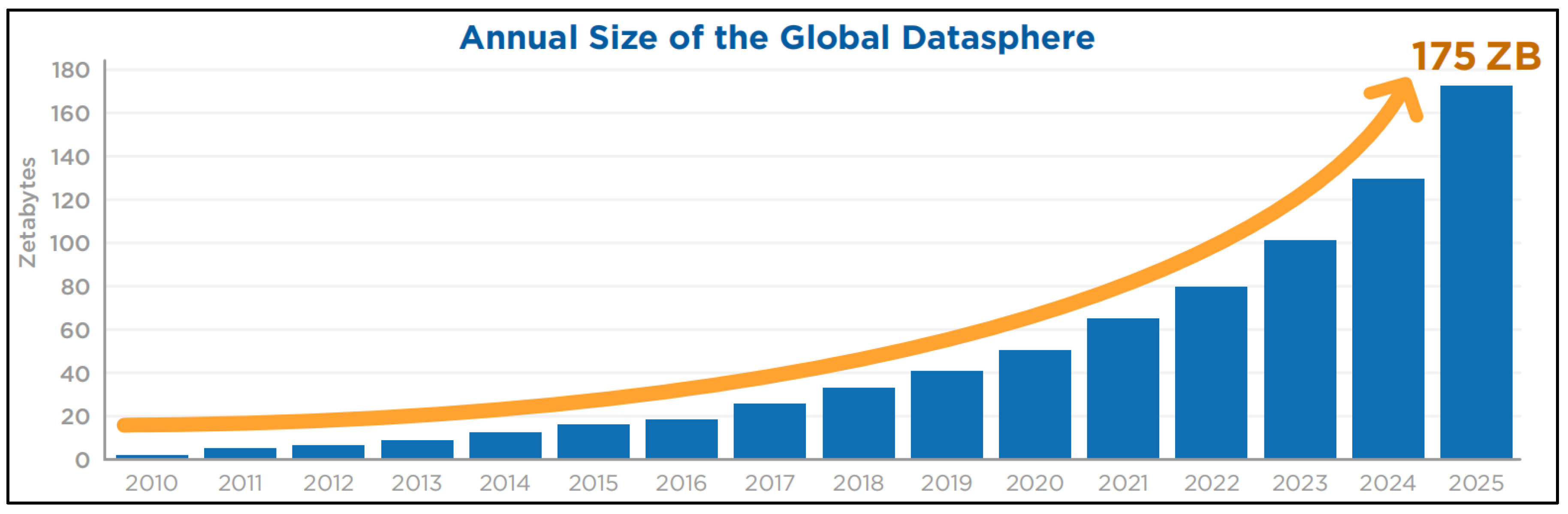
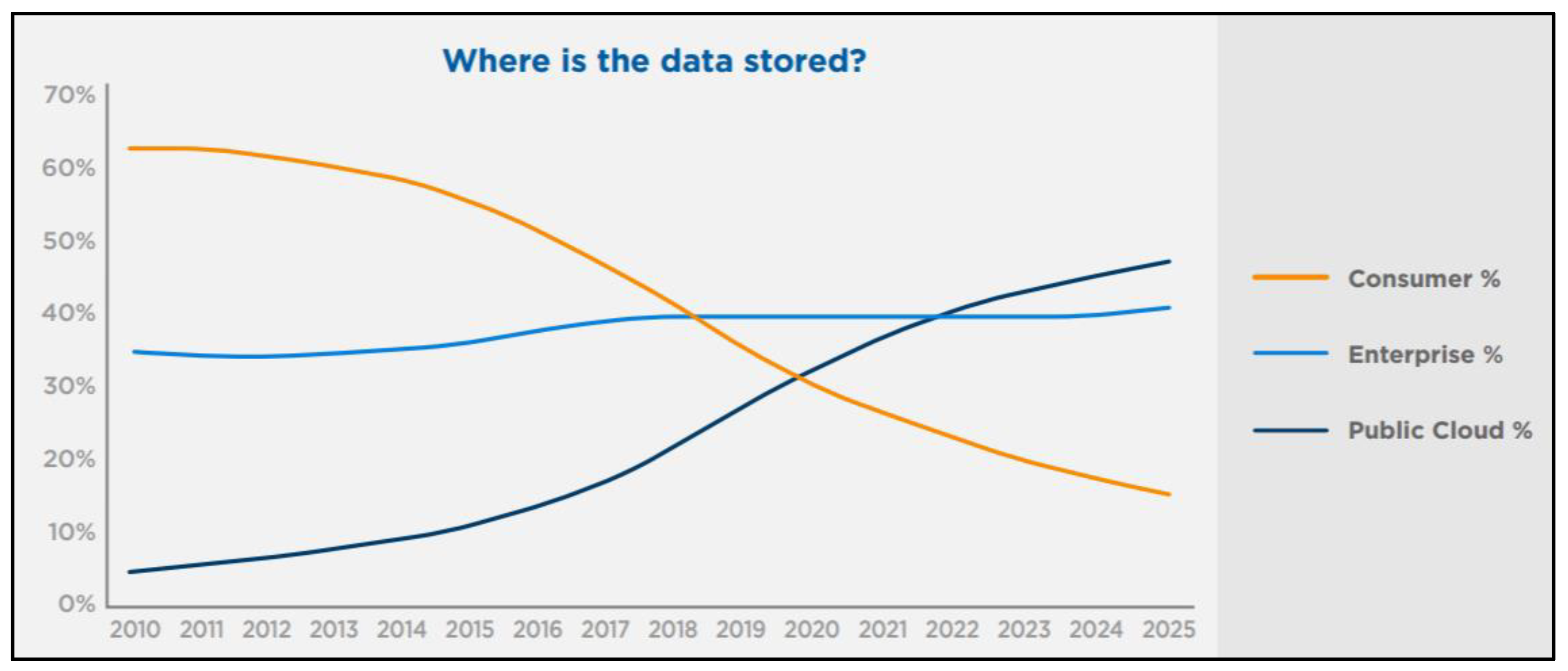
2.1. Big Data and BEOD
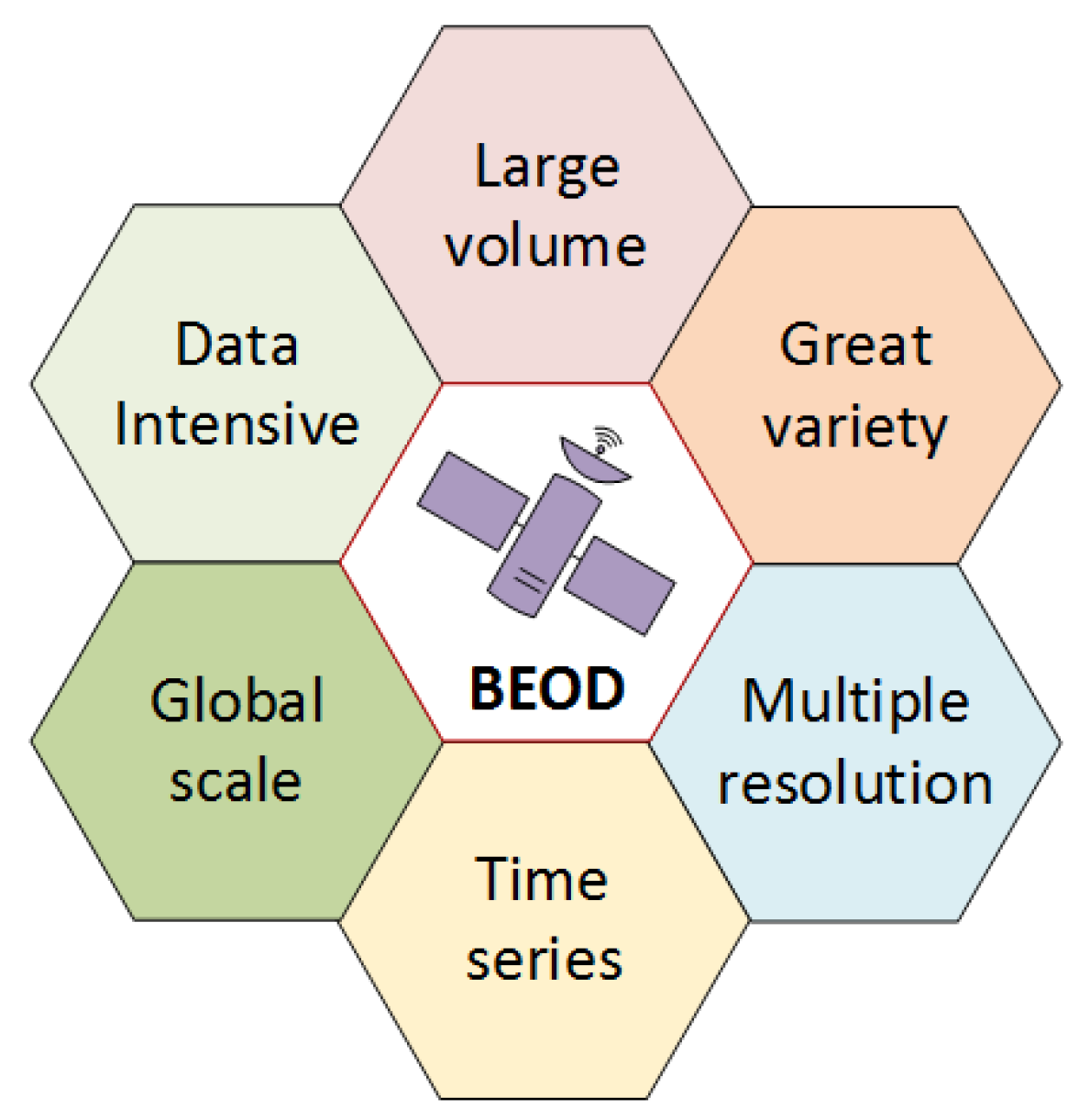
2.2. The Characteristics of BEOD
- Large volume: One remote sensing image amounts to 1 GB, which has led to an explosion in the volume of data as a whole. For example, only one of NASA archives holds 7.5 PB of data with nearly 7000 unique datasets, which only contain in-domain EO data [25].
- Great variety: Due to the difference of sensors, the format of EO data obtained is also varied, such as Hierarchical Data Format (HDF), network Common Data Format (NetCDF), and GeoTiff. Meanwhile, the data structure is also different, which will be a complicated process in the fusion analysis of multisource data [38].
- Multiple resolutions: With the improvement of remote sensing technology, data resolution is also getting better. Most of the network available data are also in the meter level, such as SPOT-5 (2.5 m), IKONOS (1 m), and QuickBird (0.61 m).
- Time series: Remote sensing satellites dynamically monitor the changes according to old and new data, which is unmatched by artificial field measurement and aerial photogrammetry. For example, land satellites 4 and 5 can cover the Earth every 16 days, and the National Oceanic and Atmospheric Administration (NOAA) weather satellite can receive two images per day.
- Global scale: Remote sensing can detect large-scale areas from the air and even the space in a short period, and obtain valuable remote sensing data. These data expand people′s visual space, for example, a terrestrial satellite image, covers an area of more than 30,000 square kilometers.
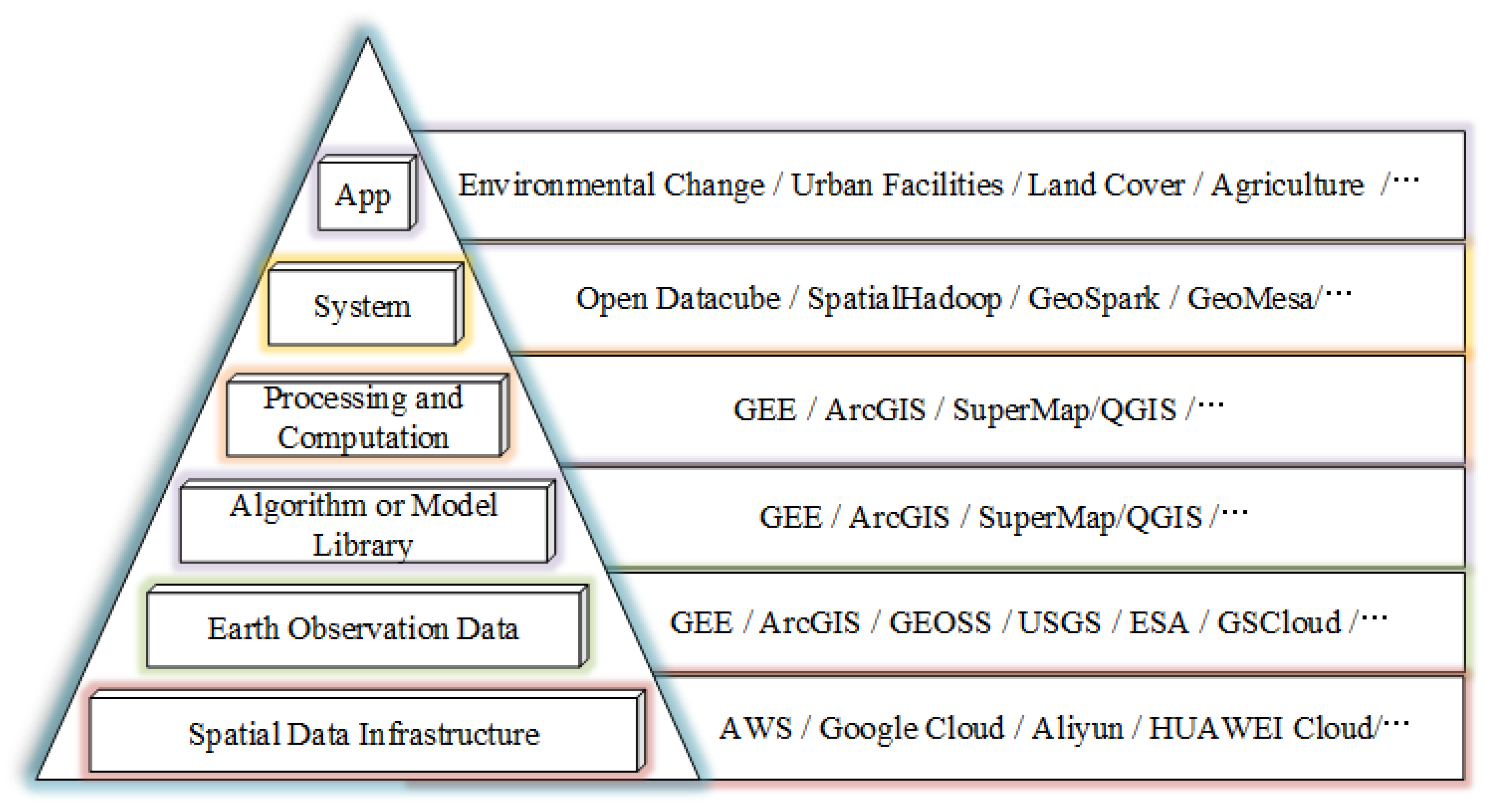
3. Cloud Computing
3.1. Cloud Computing and Spatial Cloud Computing
3.2. Cloud Computing for BEOD
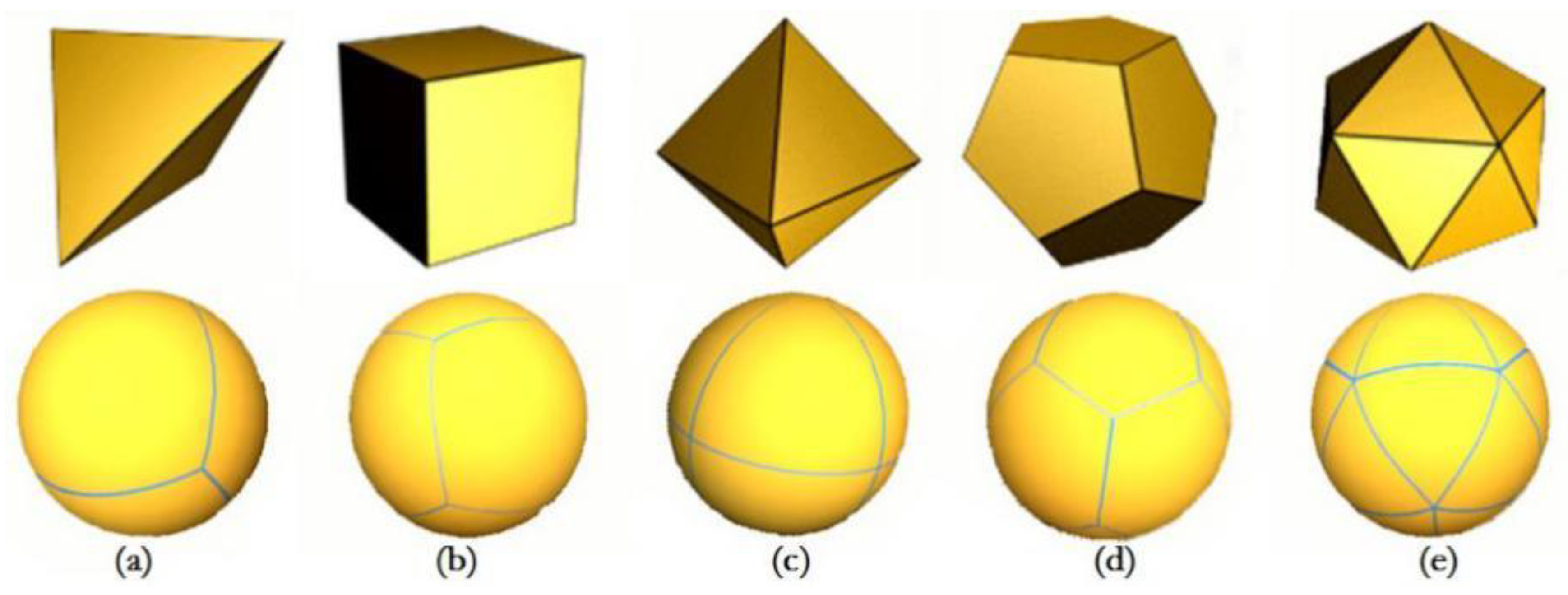
4. Discrete Global Grid Systems (DGGS)
4.1. DGGS Standards and Models
4.2. DGGS for BEOD
5. Opportunities and Challenges
5.1. Opportunities
5.1.1. EO Data Organization and Management
5.1.2. Fusion Analysis of Global- or Regional-Scale EO Data
5.1.3. Integration with Cloud Computing Technologies
5.2. Challenges
5.2.1. DGGS Grid Coding in Cloud Environment
5.2.2. Spatiotemporal DGGS Framework for EO Data
5.2.3. Data Interface with Modeling via Cloud Computing and DGGS
6. Conclusions
Author Contributions
Funding
Acknowledgments
Conflicts of Interest
References
- Xia, J.; Yang, C.; Li, Q. Building a spatiotemporal index for earth observation big data. Int. J. Appl. Earth Obs. 2018, 73, 245–252. [Google Scholar] [CrossRef]
- Guo, H. Big earth data: A new frontier in earth and information sciences. Big Earth Data 2017, 1, 4–20. [Google Scholar] [CrossRef] [Green Version]
- CEOS. Committee on Earth Observation Satellites (Ceos) Database. Available online: http://database.eohandbook.com/ (accessed on 16 August 2019).
- ESA. Sentinel Data Access Annual Report. 2017. Available online: https://sentinel.esa.int/web/sentinel/news/-/article/sentinel-data-access-annual-report-2017 (accessed on 24 August 2019).
- Ramo, R.; García, M.; Rodríguez, D.; Chuvieco, E. A data mining approach for global burned area mapping. Int. J. Appl. Earth Obs. 2018, 73, 39–51. [Google Scholar] [CrossRef]
- Oliphant, A.J.; Thenkabail, P.S.; Teluguntla, P.; Xiong, J.; Gumma, M.K.; Congalton, R.G.; Yadav, K. Mapping cropland extent of southeast and northeast asia using multi-year time-series landsat 30-m data using a random forest classifier on the google earth engine cloud. Int. J. Appl. Earth Obs. 2019, 81, 110–124. [Google Scholar] [CrossRef]
- Guo, H.; Liu, Z.; Jiang, H.; Wang, C.; Liu, J.; Liang, D. Big earth data: A new challenge and opportunity for digital earth’s development. Int. J. Digit. Earth 2016, 10, 1–12. [Google Scholar] [CrossRef] [Green Version]
- Guo, H.; Wang, L.; Liang, D. Big earth data from space: A new engine for earth science. Sci. Bull. 2016, 61, 505–513. [Google Scholar] [CrossRef]
- Xu, X.; Xie, F.; Zhou, X. Research on spatial and temporal characteristics of drought based on gis using remote sensing big data. Clust. Comput. 2016, 19, 757–767. [Google Scholar] [CrossRef]
- Li, D.; Zhang, L.; Xia, G. Automatic analysis and mining of remote sensing big data. Acta Geodaetica et Cartographica Sinica 2014, 43, 1211–1216. [Google Scholar]
- Rathore, M.M.U.; Paul, A.; Ahmad, A.; Chen, B.W.; Huang, B.; Ji, W. Real-time big data analytical architecture for remote sensing application. IEEE J. Sel. Top. Appl. Earth Obs. Remote Sens. 2015, 8, 4610–4621. [Google Scholar] [CrossRef]
- Waldner, F.; Duveiller, G.; Defourny, P. Local adjustments of image spatial resolution to optimize large-area mapping in the era of big data. Int. J. Appl. Earth Obs. 2018, 73, 374–385. [Google Scholar] [CrossRef]
- Ma, J.; Sun, W.W.; Yang, G.; Zhang, D.F. Hydrological analysis using satellite remote sensing big data and crest model. IEEE Access 2018, 6, 9006–9016. [Google Scholar] [CrossRef]
- Li, G.; Huang, Z. Data infrastructure for remote sensing big data: Integration, management and on-demand service. Jisuanji Yanjiu Yu Fazhan/Comput. Res. Dev. 2017, 54, 267–283. [Google Scholar]
- NIST. Nist Cloud Computing Program—NCCP. Available online: https://www.nist.gov/programs-projects/nist-cloud-computing-program-nccp (accessed on 10 August 2019).
- Yang, C.; Goodchild, M.; Huang, Q.; Nebert, D.; Raskin, R.; Xu, Y.; Bambacus, M.; Fay, D. Spatial cloud computing: How can the geospatial sciences use and help shape cloud computing? Int. J. Digit. Earth 2011, 4, 305–329. [Google Scholar] [CrossRef]
- Li, Q.; Li, D. Big data gis. Wuhan Daxue Xuebao (Xinxi Kexue Ban)/Geomat. Inf. Sci. Wuhan Univ. 2014, 39, 641–644, 666. [Google Scholar]
- Yao, X.; Yang, J.; Li, L.; Ye, S.; Yun, W.; Zhu, D. Parallel algorithm for partitioning massive spatial vector data in cloud environment. Wuhan Daxue Xuebao (Xinxi Kexue Ban)/Geomat. Inf. Sci. Wuhan Univ. 2018, 43, 1092–1097. [Google Scholar]
- Yao, X.; Mokbel, M.; Ye, S.; Li, G.; Alarabi, L.; Eldawy, A.; Zhao, Z.; Zhao, L.; Zhu, D. Landqv2: A mapreduce-based system for processing arable land quality big data. ISPRS Int. Geo.-Inf. 2018, 7, 271. [Google Scholar] [CrossRef] [Green Version]
- Zhao, X.; Ben, J.; Sun, W.; Tong, X. Overview of the research progress in the earth tessellation grid. Cehui Xuebao/Acta Geodaetica et Cartographica Sinica 2016, 45, 1–14. [Google Scholar]
- OGC. Topic 21: Discrete Global Grid Systems Abstract Specification. Available online: http://www.opengeospatial.org/projects/groups/dggsswg (accessed on 16 August 2019).
- Bauer-Marschallinger, B.; Sabel, D.; Wagner, W. Optimisation of global grids for high-resolution remote sensing data. Comput. Geosci. 2014, 72, 84–93. [Google Scholar] [CrossRef]
- Lin, B.; Zhou, L.; Xu, D.; Zhu, A.X.; Lu, G. A discrete global grid system for earth system modeling. Int. J. Geogr. Inf. Sci. 2017, 32, 711–737. [Google Scholar] [CrossRef]
- Yao, X.; Li, G. Big spatial vector data management: A review. Big Earth Data 2018, 2, 108–129. [Google Scholar] [CrossRef]
- Chi, M.M.; Plaza, A.; Benediktsson, J.A.; Sun, Z.Y.; Shen, J.S.; Zhu, Y.Y. Big data for remote sensing: Challenges and opportunities. Proc. IEEE 2016, 104, 2207–2219. [Google Scholar] [CrossRef]
- Reinsel, D.; Gantz, J.; Rydning, J. Data Age 2025: The Digitization of the World from Edge to Core; IDC Analyze the Future: Framingham, MA, USA, 2018; pp. 1–28. [Google Scholar]
- Guojin, H.; Guizhou, W.; Tengfei, L.; Yan, P.; Wei, J.; Ranyu, Y.; Weili, J.; Zhaoming, Z. Opening and sharing of big earth observation data: Challenges and countermeasures. Bull. Chin. Acad. Sci. 2018, 33, 783–790. [Google Scholar]
- Zhang, P.; Lu, Q.; Hu, X.; Gu, S.; Yang, L.; Min, M.; Chen, L.; Xu, N.; Sun, L.; Bai, W.; et al. Latest progress of the chinese meteorological satellite program and core data processing technologies. Adv. Atmos. Sci. 2019, 36, 1027–1045. [Google Scholar] [CrossRef]
- Sudmanns, M.; Tiede, D.; Lang, S.; Baraldi, A. Semantic and syntactic interoperability in online processing of big earth observation data. Int. J. Digit. Earth 2018, 11, 95–112. [Google Scholar] [CrossRef] [PubMed] [Green Version]
- Koubarakis, M.; Kyzirakos, K.; Nikolaou, C.; Garbis, G.; Bereta, K.; Dogani, R.; Giannakopoulou, S.; Smeros, P.; Savva, D.; Stamoulis, G.; et al. Managing big, linked, and open earth-observation data using the teleios/leo software stack. IEEE Geosci. Remote Sens. Mag. 2016, 4, 23–37. [Google Scholar] [CrossRef]
- Boulila, W.; Farah, I.R.; Hussain, A. A novel decision support system for the interpretation of remote sensing big data. Earth Sci. Inform. 2018, 11, 31–45. [Google Scholar] [CrossRef] [Green Version]
- Wang, L.; Zhong, H.; Ranjan, R.; Zomaya, A.; Liu, P. Estimating the statistical characteristics of remote sensing big data in the wavelet transform domain. IEEE Trans. Emerg. Top. Comput. 2014, 2, 324–337. [Google Scholar] [CrossRef]
- Huang, Y.B.; Chen, Z.X.; Yu, T.; Huang, X.Z.; Gu, X.F. Agricultural remote sensing big data: Management and applications. J. Integr. Agric. 2018, 17, 1915–1931. [Google Scholar] [CrossRef]
- Laney, D. 3-d data management: Controlling data volume, velocity, and variety. META Group Res. Note 2001, 6, 1. [Google Scholar]
- Marchetti, P.G.; Soille, P.; Bruzzone, L. A special issue on big data from space for geoscience and remote sensing. IEEE Geosci. Remote Sens. Mag. 2016, 4, 7–9. [Google Scholar] [CrossRef]
- Ma, Y.; Wu, H.P.; Wang, L.Z.; Huang, B.M.; Ranjan, R.; Zomaya, A.; Jie, W. Remote sensing big data computing: Challenges and opportunities. Future Gener. Comput. Syst. 2015, 51, 47–60. [Google Scholar] [CrossRef]
- Zhang, X.M.; He, G.J.; Zhang, Z.M.; Peng, Y.; Long, T.F. Spectral-spatial multi-feature classification of remote sensing big data based on a random forest classifier for land cover mapping. Clust. Comput. 2017, 20, 2311–2321. [Google Scholar] [CrossRef]
- Pierce, L.; IEEE. Big data issues for remote sensing: Variety. In Proceedings of the 2016 IEEE International Geoscience and Remote Sensing Symposium, Beijing, China, 10–15 July 2016; pp. 7593–7596. [Google Scholar]
- Ma, Y.; Wang, L.; Liu, P.; Ranjan, R. Towards building a data-intensive index for big data computing—A case study of remote sensing data processing. Inf. Sci. 2015, 319, 171–188. [Google Scholar] [CrossRef]
- Yao, X.; Mokbel, M.F.; Alarabi, L.; Eldawy, A.; Yang, J.; Yun, W.; Li, L.; Ye, S.; Zhu, D. Spatial coding-based approach for partitioning big spatial data in hadoop. Comput. Geosci. 2017, 106, 60–67. [Google Scholar] [CrossRef] [Green Version]
- Gorelick, N.; Hancher, M.; Dixon, M.; Ilyushchenko, S.; Thau, D.; Moore, R. Google earth engine: Planetary-scale geospatial analysis for everyone. Remote Sens. Environ. 2017, 202, 18–27. [Google Scholar] [CrossRef]
- Huang, Q.Y.; Yang, C.W.; Liu, K.; Xia, J.Z.; Xu, C.; Li, J.; Gui, Z.P.; Sun, M.; Li, Z.L. Evaluating open-source cloud computing solutions for geosciences. Comput. Geosci. 2013, 59, 41–52. [Google Scholar] [CrossRef]
- Kiemle, S.; Molch, K.; Schropp, S.; Weiland, N.; Mikusch, E. Big data management in earth observation the german satellite data archive at the german aerospace center. IEEE Geosci. Remote Sens. Mag. 2016, 4, 51–58. [Google Scholar] [CrossRef]
- Yang, C.; Yu, M.; Hu, F.; Jiang, Y.; Li, Y. Utilizing cloud computing to address big geospatial data challenges. Comput. Environ. Urban Syst. 2017, 61, 120–128. [Google Scholar] [CrossRef] [Green Version]
- Rathore, M.M.; Ahmad, A.; Paul, A.; Daniel, A. Hadoop based real-time big data architecture for remote sensing earth observatory system. In Proceedings of the 2015 6th International Conference on Computing, Communication and Networking Technologies (ICCCNT), Denton, TX, USA, 13–15 July 2015; pp. 204–210. [Google Scholar]
- Xie, J.; Li, G. Implementing next-generation national earth observation data infrastructure to integrate distributed big earth observation data. In Proceedings of the 2016 IEEE international Geoscience and Remote Sensing Symposium, Beijing, China, 10–15 July 2016; pp. 194–197. [Google Scholar]
- Jing, W.P.; Huo, S.Q.; Miao, Q.C.; Chen, X.B. A model of parallel mosaicking for massive remote sensing images based on spark. IEEE Access 2017, 5, 18229–18237. [Google Scholar] [CrossRef]
- Fan, J.Q.; Yan, J.N.; Ma, Y.; Wang, L.Z. Big data integration in remote sensing across a distributed metadata-based spatial infrastructure. Remote Sens. 2018, 10, 7. [Google Scholar] [CrossRef] [Green Version]
- Nativi, S.; Mazzetti, P.; Santoro, M.; Papeschi, F.; Craglia, M.; Ochiai, O. Big data challenges in building the global earth observation system of systems. Environ. Model. Softw. 2015, 68, 1–26. [Google Scholar] [CrossRef]
- Sudmanns, M.; Tiede, D.; Lang, S.; Bergstedt, H.; Trost, G.; Augustin, H.; Baraldi, A.; Blaschke, T. Big earth data: Disruptive changes in earth observation data management and analysis? Int. J. Digit. Earth 2019, 1–19. [Google Scholar] [CrossRef]
- Eldawy, A.; Mokbel, M.F. Spatialhadoop: A Mapreduce Framework for Spatial Data. In Proceedings of the 31st IEEE International Conference on Data Engineering, Seoul, Korea, 13–17 April 2015; IEEE Computer Society: Seoul, Korea, 2015; pp. 1352–1363. [Google Scholar]
- Wang, L.; Ma, Y.; Yan, J.; Chang, V.; Zomaya, A.Y. Pipscloud: High performance cloud computing for remote sensing big data management and processing. Future Gener. Comput. Syst. 2018, 78, 353–368. [Google Scholar] [CrossRef] [Green Version]
- Lewis, A.; Lymburner, L.; Purss, M.B.J.; Brooke, B.; Evans, B.; Ip, A.; Dekker, A.G.; Irons, J.R.; Minchin, S.; Mueller, N.; et al. Rapid, high-resolution detection of environmental change over continental scales from satellite data – the earth observation data cube. Int. J. Digit. Earth 2015, 9, 106–111. [Google Scholar] [CrossRef]
- Moguel, E.; Preciado, J.C.; Sanchez-Figueroa, F.; Preciado, M.A.; Hernandez, J. Multilayer big data architecture for remote sensing in eolic parks. IEEE J. Sel. Top. Appl. Earth Obs. Remote Sens. 2015, 8, 4714–4719. [Google Scholar] [CrossRef]
- Dong, J.W.; Kuang, W.H.; Liu, J.Y. Continuous land cover change monitoring in the remote sensing big data era. Sci. China Earth Sci. 2017, 60, 2223–2224. [Google Scholar] [CrossRef]
- Huang, Y.B. Infrastructural development for farm-scale remote sensing big data service. In Multispectral, Hyperspectral, and Ultraspectral Remote Sensing Technology, Techniques and Applications Vii; Larar, A.M., Suzuki, M., Wang, J., Eds.; SPIE: Honolulu, HI, USA, 2018; Volume 10780. [Google Scholar]
- Zhou, H.; Taal, A.; Koulouzis, S.; Wang, J.; Hu, Y.; Suciu, G.; Poenaru, V.; Laat, C.d.; Zhao, Z. Dynamic Real-Time Infrastructure Planning and Deployment for Disaster Early Warning Systems; Springer, Cham: Wuxi, China, 2018; pp. 644–654. [Google Scholar]
- Evangelidis, K.; Ntouros, K.; Makridis, S.; Papatheodorou, C. Geospatial services in the cloud. Comput. Geosci. 2014, 63, 116–122. [Google Scholar] [CrossRef] [Green Version]
- Sahr, K.; White, D.; Kimerling, A.J. Geodesic discrete global grid systems. Cartogr. Geogr. Inf. Sci. 2003, 30, 121–134. [Google Scholar] [CrossRef] [Green Version]
- Peterson, P.R. Discrete global grid systems. Int. Encycl. Geogr. 2017, 1–10. [Google Scholar]
- Peterson, P.R.; Percivall, G.; Purss, M.B.J.; Samavati, F.; Gibb, R. Discrete global grid systems—A framework for the next era in big earth data. In AGU Fall Meeting Abstracts; IEEE: San Francisco, CA, USA, 2015. [Google Scholar]
- Gregory, M.J.; Kimerling, A.J.; White, D.; Sahr, K. A comparison of intercell metrics on discrete global grid systems. Comput. Environ. Urban Syst. 2008, 32, 188–203. [Google Scholar] [CrossRef]
- Purss, M.B.J.; Peterson, P.R.; Strobl, P.; Dow, C.; Sabeur, Z.A.; Gibb, R.G.; Ben, J. Datacubes: A discrete global grid systems perspective. Cartogr. Int. J. Geogr. Inf. Geovisualization 2019, 54, 63–71. [Google Scholar] [CrossRef]
- Tao, M.; Wen, Y.; GuangXiong, P.; Su, L.; Zhangang, W. The study on error analysis of discretization area in discrete global grid system. Procedia Environ. Sci. 2011, 10, 1122–1128. [Google Scholar] [CrossRef] [Green Version]
- Zhou, L.; Lian, W.; Lv, G.; Zhu, A.X.; Lin, B. Efficient encoding and decoding algorithm for triangular discrete global grid based on hybrid transformation strategy. Comput. Environ. Urban Syst. 2018, 68, 110–120. [Google Scholar] [CrossRef]
- Gibb, R.G. The rhealpix discrete global grid system. In IOP Conference Series: Earth and Environmental Science; IOP Publishing: Halifax, NS, Canada, 2016; p. 012012. [Google Scholar]
- Lewis, A.; Oliver, S.; Lymburner, L.; Evans, B.; Wyborn, L.; Mueller, N.; Raevksi, G.; Hooke, J.; Woodcock, R.; Sixsmith, J.; et al. The australian geoscience data cube—Foundations and lessons learned. Remote Sens. Environ. 2017, 202, 276–292. [Google Scholar] [CrossRef]
- Sahr, K. Hexagonal discrete global grid systems for geospatial computing. Arch. Photogramm. Cartogr. Remote Sens. 2011, 22, 363–376. [Google Scholar]
- Wang, R.; Ben, J.; Du, L.; Zhou, J.; Li, Z. Encoding and operation for the planar aperture 4 hexagon grid system. Cehui Xuebao/Acta Geodaetica et Cartographica Sinica 2018, 47, 1018–1025. [Google Scholar]
- Stough, T.; Braverman, A.; Cressie, N.; Kang, E.; Michalak, A.M.; Nguyen, H. Visualizing massive spatial datasets using multi-resolution global grids. In National Institute for Applied Statistics Research Australia Working Paper Series; University of Wollongong: Wollongong, Australia, 2014. [Google Scholar]
- Li, S.; Pu, G.; Cheng, C.; Chen, B. Method for managing and querying geo-spatial data using a grid-code-array spatial index. Earth Sci. Inform. 2019, 12, 173–181. [Google Scholar] [CrossRef]
- Sahr, K. Central place indexing: Hierarchical linear indexing systems for mixed-aperture hexagonal discrete global grid systems. Cartogr. Int. J. Geogr. Inf. Geovisualization 2019, 54, 16–29. [Google Scholar] [CrossRef]
- Vince, A.; Zheng, X. Arithmetic and fourier transform for the pyxis multi-resolution digital earth model. Int. J. Digit. Earth 2009, 2, 59–79. [Google Scholar] [CrossRef]
- Sirdeshmukh, N.; Verbree, E.; Oosterom, P.V.; Psomadaki, S.; Kodde, M. Utilizing a discrete global grid system for handling point clouds with varying locations, times, and levels of detail. Cartogr. Int. J. Geogr. Inf. Geovisualization 2019, 54, 4–15. [Google Scholar] [CrossRef] [Green Version]
- Bravo, G.; Castro, H.; Moreno, A.; Ariza-Porras, C.; Galindo, G.; Cabrera, E.; Valbuena, S.; Lozano-Rivera, P. Architecture for a Colombian Data Cube Using Satellite Imagery for Environmental Applications; Colombian Conference on Computing: Cham, Germany; Springer International Publishing: Cham, Germany, 2017; pp. 227–241. [Google Scholar]
- Giuliani, G.; Chatenoux, B.; De Bono, A.; Rodila, D.; Richard, J.-P.; Allenbach, K.; Dao, H.; Peduzzi, P. Building an earth observations data cube: Lessons learned from the swiss data cube (sdc) on generating analysis ready data (ard). Big Earth Data 2017, 1, 100–117. [Google Scholar] [CrossRef] [Green Version]
- Yao, X.; Liu, Y.; Cao, Q.; Li, J.; Huang, R.; Woodcock, R.; Paget, M.; Wang, J.; Li, G. China Data Cube (CDC) for Big Earth Observation Data: Lessons Learned from the Design and Implementation. In Proceedings of the 2018 International Workshop on Big Geospatial Data and Data Science (BGDDS), Wuhan, China, 22–23 September 2018; pp. 1–3. [Google Scholar]
- Asmaryan, S.; Muradyan, V.; Tepanosyan, G.; Hovsepyan, A.; Saghatelyan, A.; Astsatryan, H.; Grigoryan, H.; Abrahamyan, R.; Guigoz, Y.; Giuliani, G. Paving the way towards an armenian data cube. Data 2019, 4, 117. [Google Scholar] [CrossRef] [Green Version]
- Bowater, D.; Stefanakis, E. Research Directions for the Rhealpix Discrete Global Grid System; Spatial Knowledge and Information: Banff, AB, Canada, 2019. [Google Scholar]
- Ben, J.; Li, Y.; Zhou, C.; Wang, R.; Du, L. Algebraic encoding scheme for aperture 3 hexagonal discrete global grid system. Sci. China Earth Sci. 2017, 61, 215–227. [Google Scholar] [CrossRef]
- Mahdavi Amiri, A.; Alderson, T.; Samavati, F. Geospatial data organization methods with emphasis on aperture-3 hexagonal discrete global grid systems. Cartogr. Int. J. Geogr. Inf. Geovisualization 2019, 54, 30–50. [Google Scholar] [CrossRef]
- Liu, Y.; Chen, L.; Jing, N.; Xiong, W. Parallel batch-building remote sensing images tile pyramid with mapreduce. Wuhan Daxue Xuebao (Xinxi Kexue Ban)/Geomat. Inf. Sci. Wuhan Univ. 2013, 38, 278–282. [Google Scholar]
- Chen, L.; Ma, Y.; Liu, P.; Wei, J.; Jie, W.; He, J. A review of parallel computing for large-scale remote sensing image mosaicking. Clust. Comput. 2015, 18, 517–529. [Google Scholar] [CrossRef] [Green Version]
- Giachetta, R. A framework for processing large scale geospatial and remote sensing data in mapreduce environment. Comput. Graph. 2015, 49, 37–46. [Google Scholar] [CrossRef]
- Sun, Z.; Chen, F.; Chi, M.; Zhu, Y. A spark-based big data platform for massive remote sensing data processing. In Proceedings of the 2nd International Conference on Data Science (ICDS), Sydney, Austrilia, 8–9 August 2015; University Technology Sydney: Sydney, Australia, 2015; pp. 120–126. [Google Scholar]
- Ye, S.; Liu, D.; Yao, X.; Tang, H.; Xiong, Q.; Zhuo, W.; Du, Z.; Huang, J.; Su, W.; Shen, S.; et al. Rdcrmg: A raster dataset clean & reconstitution multi-grid architecture for remote sensing monitoring of vegetation dryness. Remote Sens. 2018, 10, 1376. [Google Scholar]
- Zhou, M.; Chen, J.; Gong, J. A pole-oriented discrete global grid system: Quaternary quadrangle mesh. Comput. Geosci. 2013, 61, 133–143. [Google Scholar] [CrossRef]
- Mahdavi-Amiri, A.; Harrison, E.; Samavati, F. Hexagonal connectivity maps for digital earth. Int. J. Digit. Earth 2014, 8, 750–769. [Google Scholar] [CrossRef]
- Ghamisi, P.; Rasti, B.; Yokoya, N.; Wang, Q.; Hofle, B.; Bruzzone, L.; Bovolo, F.; Chi, M.; Anders, K.; Gloaguen, R.; et al. Multisource and multitemporal data fusion in remote sensing: A comprehensive review of the state of the art. IEEE Geosci. Remote Sens. Mag. 2019, 7, 6–39. [Google Scholar] [CrossRef] [Green Version]
- Mocnik, F.-B. A novel identifier scheme for the isea aperture 3 hexagon discrete global grid system. Cartogr. Geogr. Inf. Sci. 2019, 46, 277–291. [Google Scholar] [CrossRef]
- Tong, X.; Ben, J.; Wang, Y.; Zhang, Y.; Pei, T. Efficient encoding and spatial operation scheme for aperture 4 hexagonal discrete global grid system. Int. J. Geogr. Inf. Sci. 2013, 27, 898–921. [Google Scholar] [CrossRef]
- Amiri, A.; Samavati, F.; Peterson, P. Categorization and conversions for indexing methods of discrete global grid systems. ISPRS Int. Geo.-Inf. 2015, 4, 320–336. [Google Scholar] [CrossRef]
- Pekturk, M.K.; Unal, M. A review on real-time big data analysis in remote sensing applications. In Proceedings of the 25th Signal Processing and Communications Applications Conference (SIU), Antalya, Turkey, 15–18 May 2017; IEEE: Antalya, Turkey, 2017. [Google Scholar]
- Tong, X.; Wang, R.; Wang, L.; Lai, G.; Ding, L. An efficient integer coding and computing method for multiscale time segment. Cehui Xuebao/Acta Geodaetica et Cartographica Sinica 2016, 45, 66–76. [Google Scholar]
- Tong, X.; Cheng, C.; Wang, R.; Ding, L.; Zhang, Y.; Lai, G.; Wang, L.; Chen, B. An efficient integer coding index algorithm for multi-scale time information management. Data Knowl. Eng. 2019, 119, 123–138. [Google Scholar] [CrossRef]
- Zhang, B. Remotely sensed big data era and intelligent information extraction. Wuhan Daxue Xuebao (Xinxi Kexue Ban)/Geomat. Inf. Sci. Wuhan Univ. 2018, 43, 1861–1871. [Google Scholar]
- Yang, L.; Qin, Z. Distributed correlation model mining from remote sensing big data based on gene expression programming. Peer Peer Netw. Appl. 2018, 11, 1000–1011. [Google Scholar] [CrossRef]


| Jan. | Feb. | Mar. | Apr. | May | Jun. | Jul. | Aug. | Sep. | Oct. | Nov. | Dec. | |
|---|---|---|---|---|---|---|---|---|---|---|---|---|
| 1988 | FY-1A | |||||||||||
| 1990 | FY-1B | |||||||||||
| 1997 | FY-2A | |||||||||||
| 1999 | FY-1C | ZY-1 01 | ||||||||||
| 2000 | FY-2B | |||||||||||
| 2002 | HY-1A | ZY-2 02 | ||||||||||
| FY-1D | ||||||||||||
| 2003 | ZY-1 02 | |||||||||||
| 2004 | FY-2C | |||||||||||
| 2005 | Beijing-1 | |||||||||||
| 2006 | FY-2D | |||||||||||
| 2007 | HY-1B | ZY-1 02B | ||||||||||
| 2008 | FY-3A | HJ-1A/B | FY-2E | |||||||||
| 2010 | TH-1 01 | FY-3B | ||||||||||
| 2011 | HY-2A | ZY-1 02C | ||||||||||
| 2012 | FY-2F | TH-1 02 | SJ-9A/9B | HJ-1C | ||||||||
| ZY-3 01 | ||||||||||||
| 2013 | GF-1 | FY-3C | ZY-1 03 | |||||||||
| 2014 | GF-2 | FY-2G | ||||||||||
| ZY-1 04 | ||||||||||||
| 2015 | Beijing-2 | JL-1 A | GF-4 | |||||||||
| JL-1 SP01/SP02 | ||||||||||||
| TH-1 03 | ||||||||||||
| 2016 | ZY-3 02 | GF-3 | FY-4A | |||||||||
| Yunhai1-01 | SuperView-1 01/02 | |||||||||||
| TanSat | ||||||||||||
| 2017 | OVS-1A/B | FY-3D | ||||||||||
| JL-1 SP03 | JL-1 SP04/05/06 | |||||||||||
| 2018 | SuperView-1 03/04 | Zhangheng-1 | GF-1 02/03/04 | OVS-2 | FY-2H | CFOSAT | ||||||
| JL-1 SP07/08 | OHS-01/02/03/04 | GF-5 | GF-6 | HY-1C | HY-2B | |||||||
| 2019 | JL-1 GP01/02 | TH 2-01A/01B | JL-1 GF03A | ZY-1 02D | GF-7 | |||||||
| Yunhai1-02 | GF-12 | |||||||||||
| OHS 3A/3B/3C/3D | ||||||||||||
| OVS 3A |
| DGGS | Base Polyhedron | Partitioning Method | Providers |
|---|---|---|---|
| SCENZ-Grid [66] | Cube | Square and triangle | Landcare Research, Lincoln, New Zealand |
| Open DataCube [67] | Cube | Square | Geoscience Australia, Canberra, Australia |
| DGGRID [68] | Icosahedron | Hexagon | Southern Oregon University, Ashland, Ore, USA |
| PYXIS WorldView [60] | Icosahedron | Hexagon | PYXIS Innovation, Kingston, ON, Canada |
| HLQT [69] | Icosahedron | Hexagon | Institute of Surveying and Mapping, Information Engineering University, Zhengzhou, Henan, China |
| Uber H3 | Icosahedron | Hexagon | Uber Technologies Inc., San Francisco, CA, USA |
© 2019 by the authors. Licensee MDPI, Basel, Switzerland. This article is an open access article distributed under the terms and conditions of the Creative Commons Attribution (CC BY) license (http://creativecommons.org/licenses/by/4.0/).
Share and Cite
Yao, X.; Li, G.; Xia, J.; Ben, J.; Cao, Q.; Zhao, L.; Ma, Y.; Zhang, L.; Zhu, D. Enabling the Big Earth Observation Data via Cloud Computing and DGGS: Opportunities and Challenges. Remote Sens. 2020, 12, 62. https://0-doi-org.brum.beds.ac.uk/10.3390/rs12010062
Yao X, Li G, Xia J, Ben J, Cao Q, Zhao L, Ma Y, Zhang L, Zhu D. Enabling the Big Earth Observation Data via Cloud Computing and DGGS: Opportunities and Challenges. Remote Sensing. 2020; 12(1):62. https://0-doi-org.brum.beds.ac.uk/10.3390/rs12010062
Chicago/Turabian StyleYao, Xiaochuang, Guoqing Li, Junshi Xia, Jin Ben, Qianqian Cao, Long Zhao, Yue Ma, Lianchong Zhang, and Dehai Zhu. 2020. "Enabling the Big Earth Observation Data via Cloud Computing and DGGS: Opportunities and Challenges" Remote Sensing 12, no. 1: 62. https://0-doi-org.brum.beds.ac.uk/10.3390/rs12010062