
Using Ground Penetrating Radar for Permafrost Monitoring from 2015–2017 at CALM Sites in the Pechora River Delta

 ,
, 
Abstract
:1. Introduction
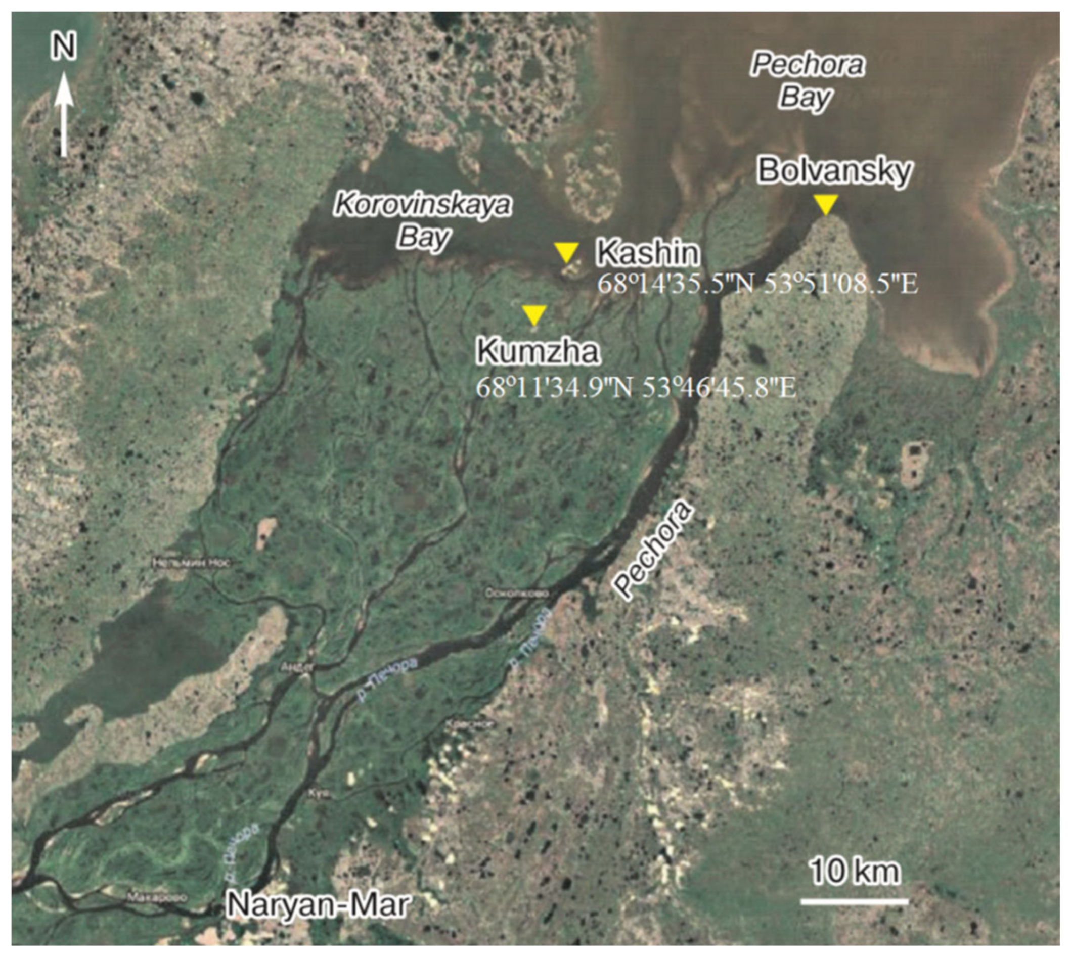
2. Study Area
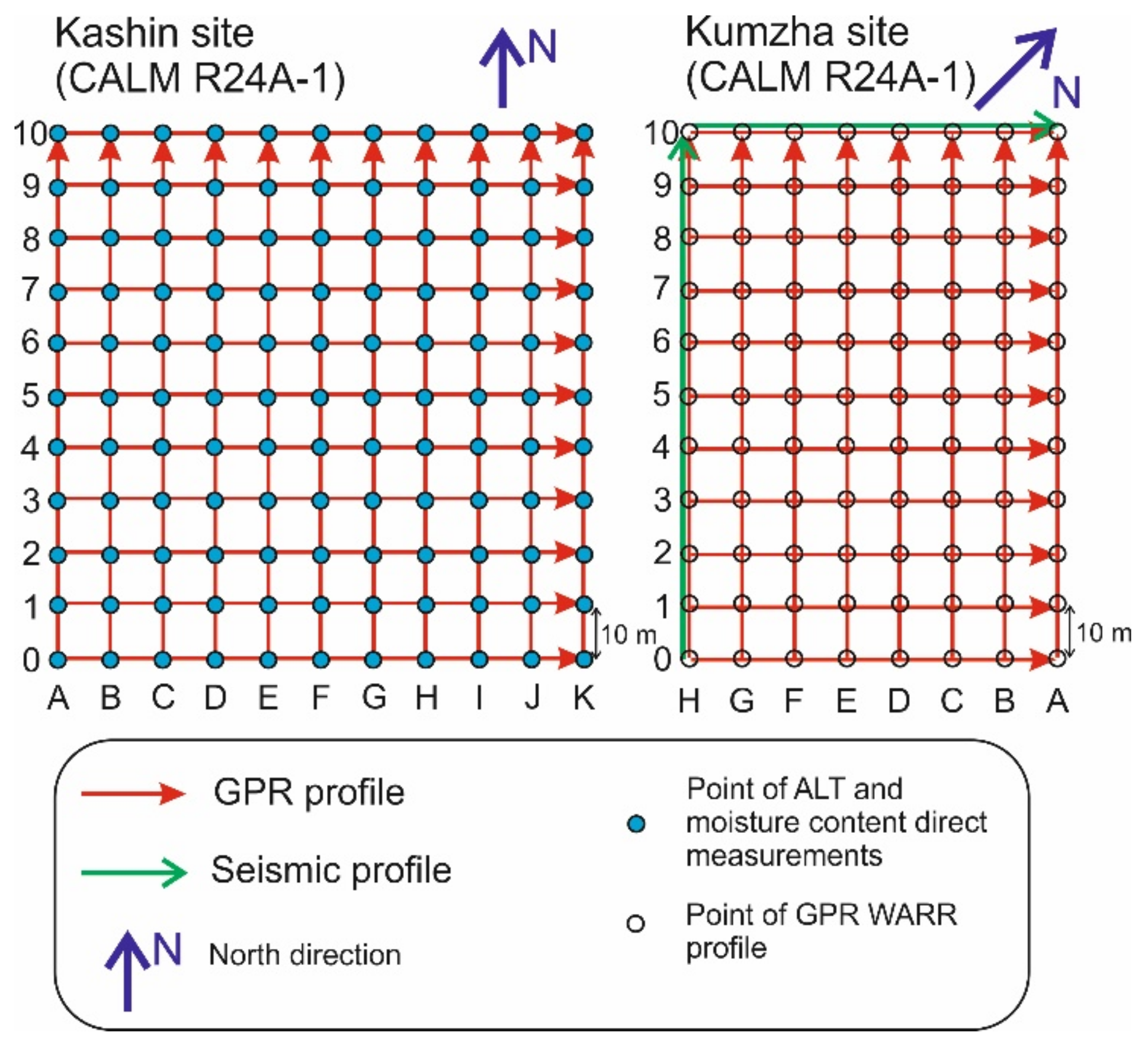
2.1. Kashin Site (CALM R24A-1)
2.2. Kumzha Site (CALM R24A-2)
3. Methods
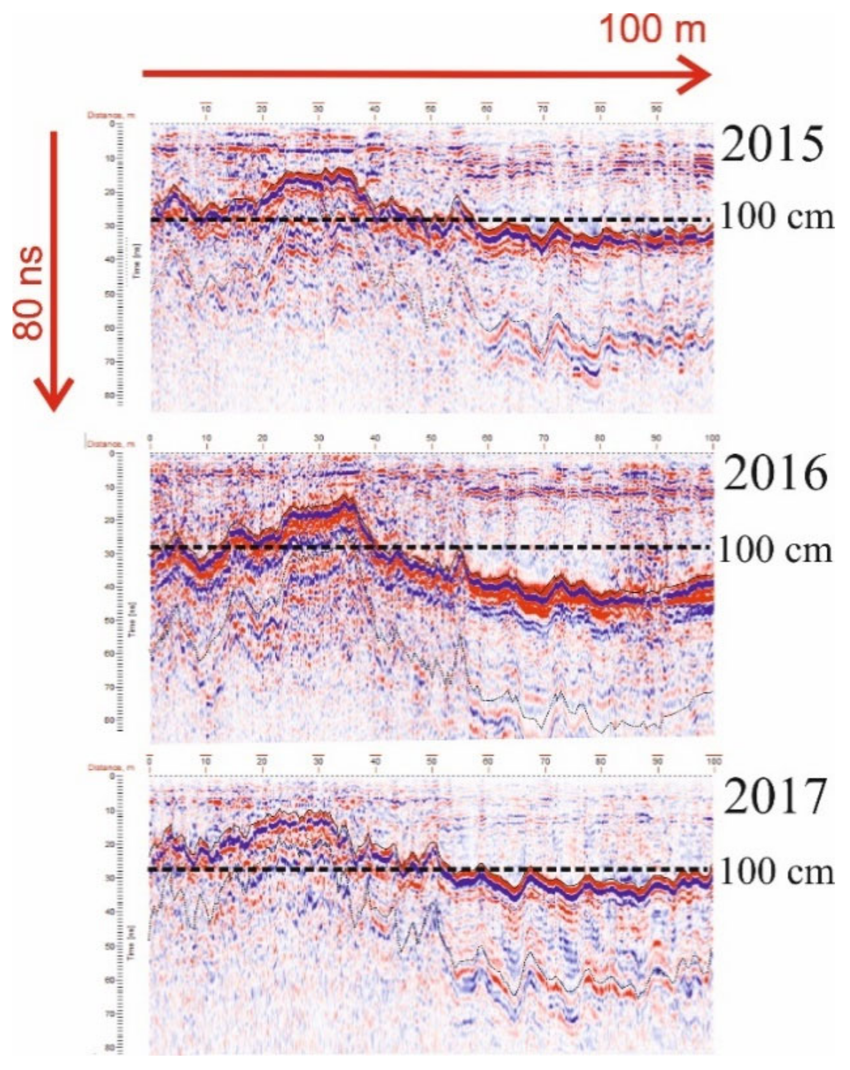
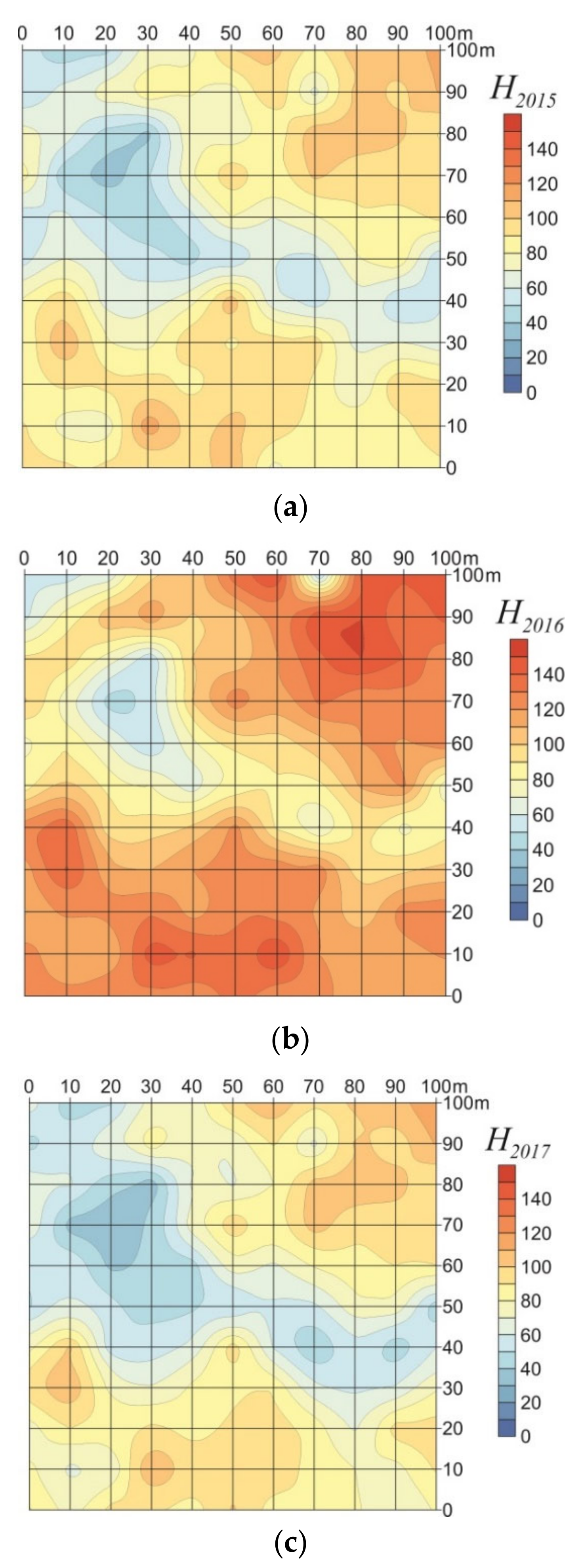
4. Results
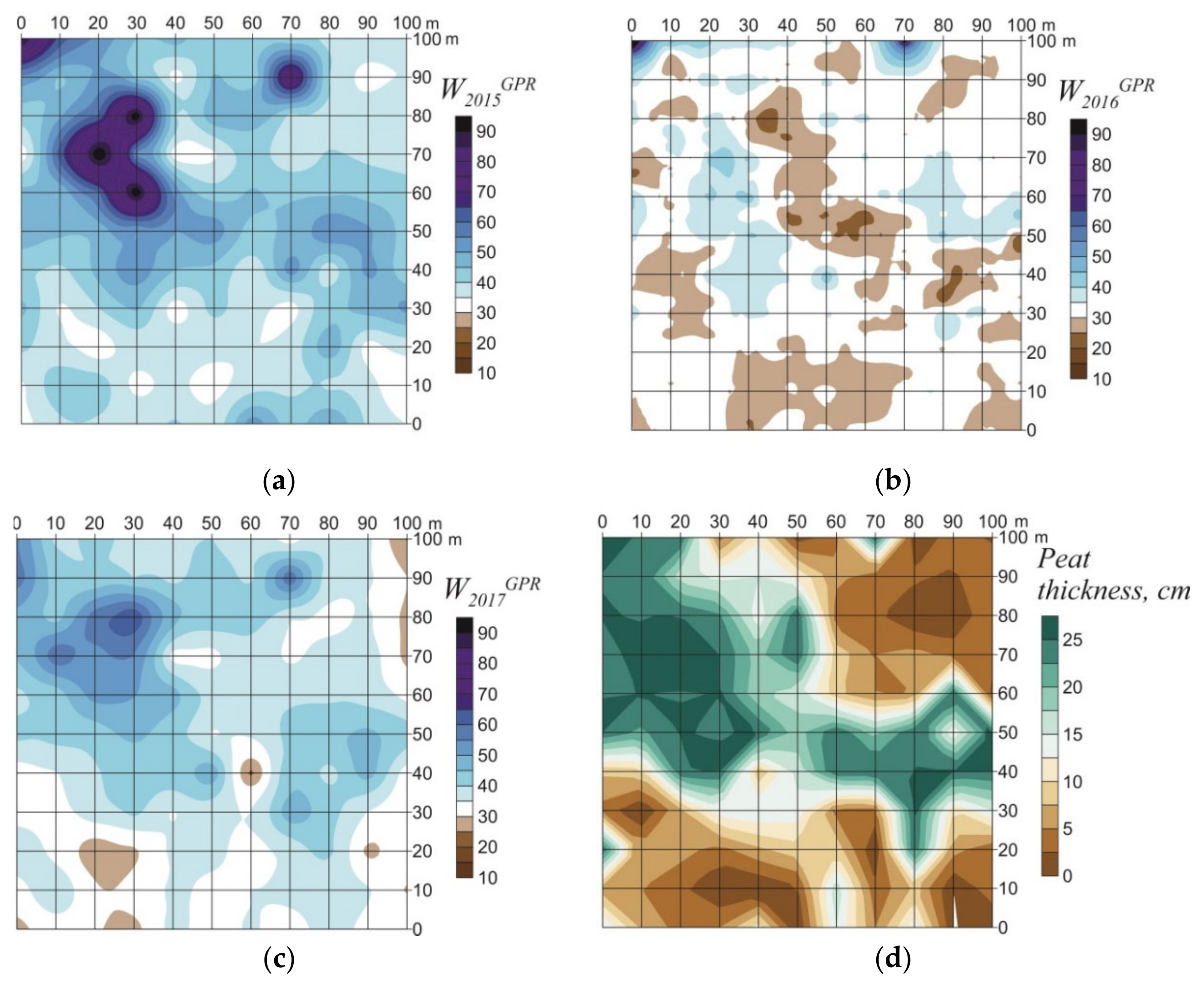
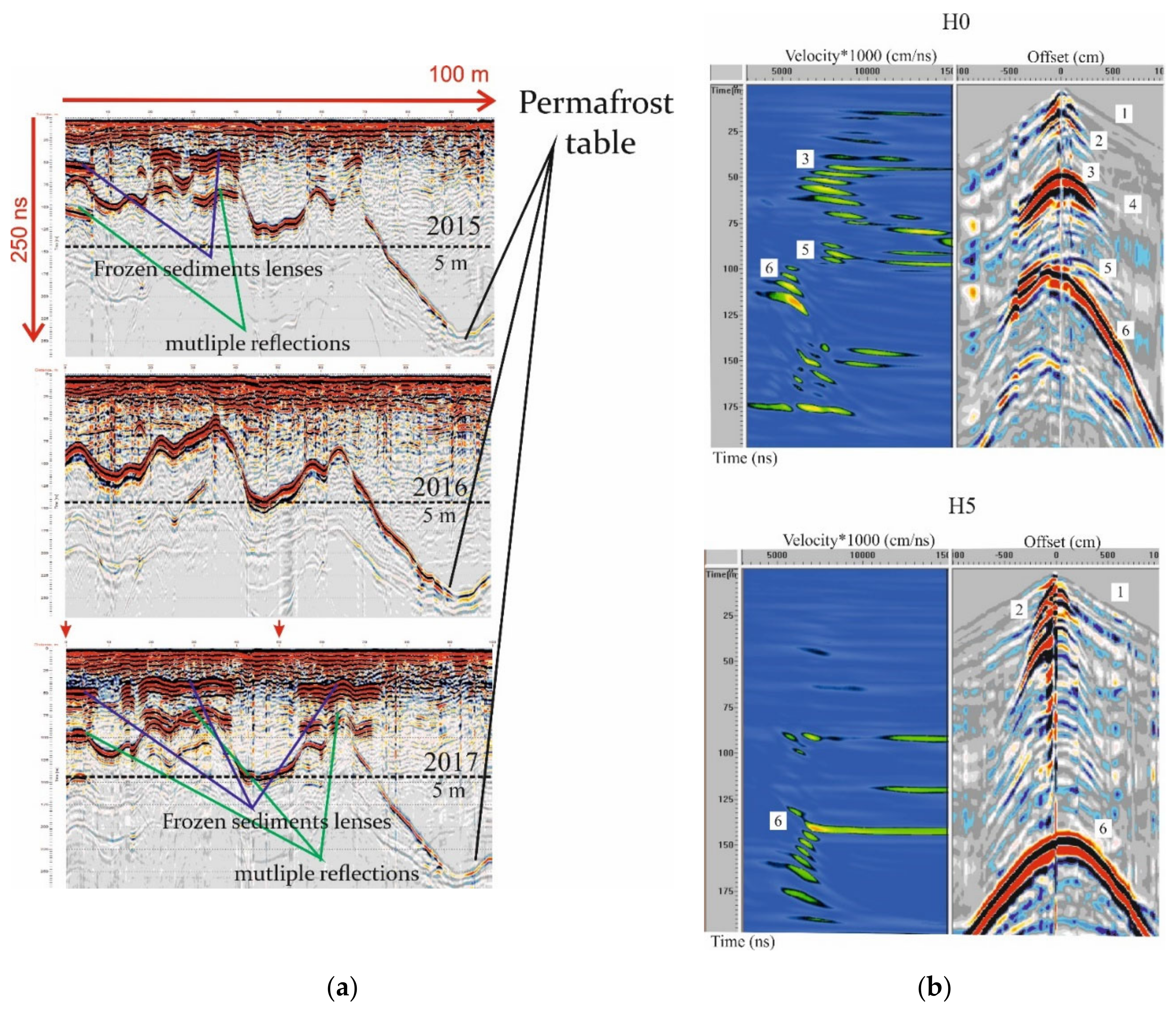
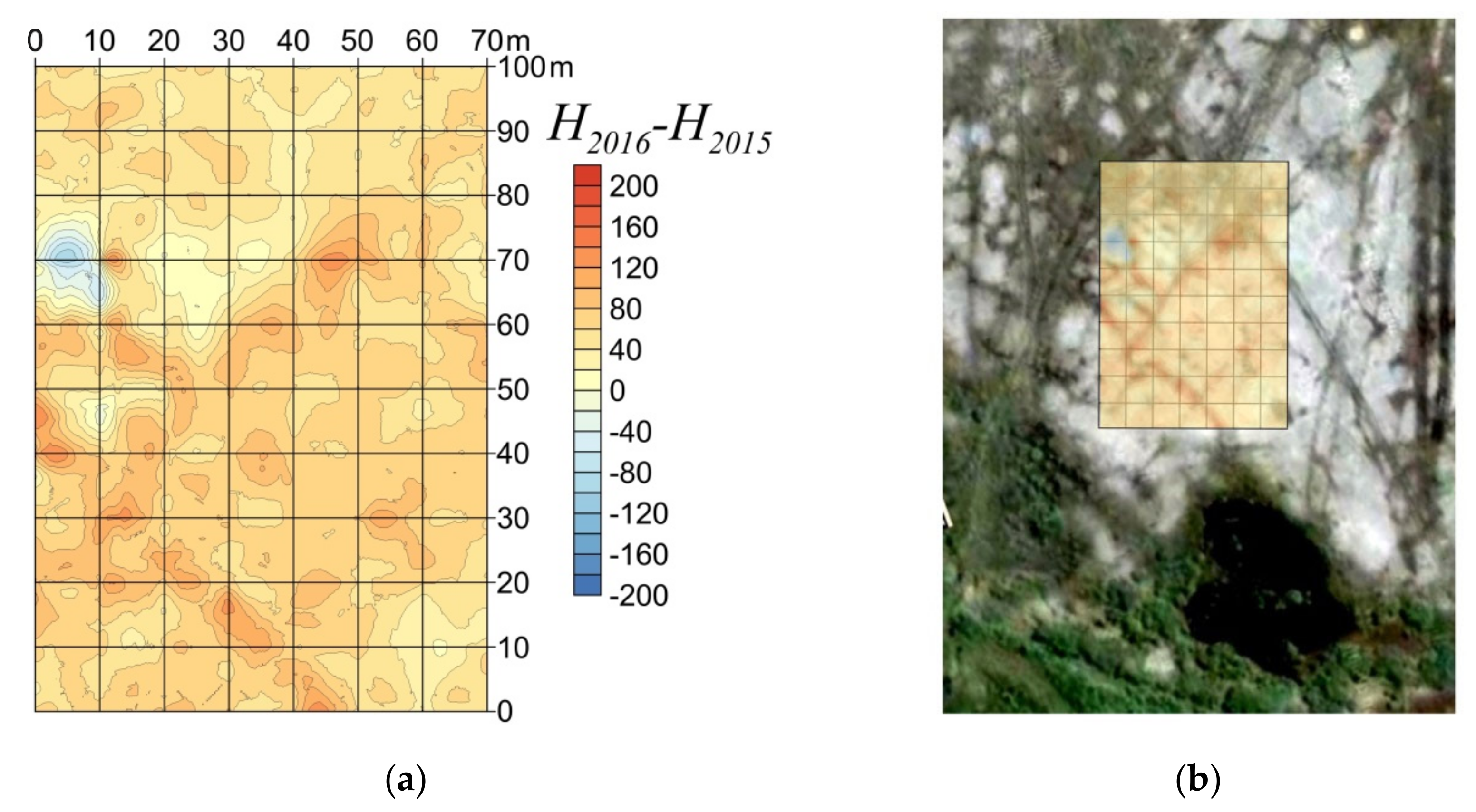
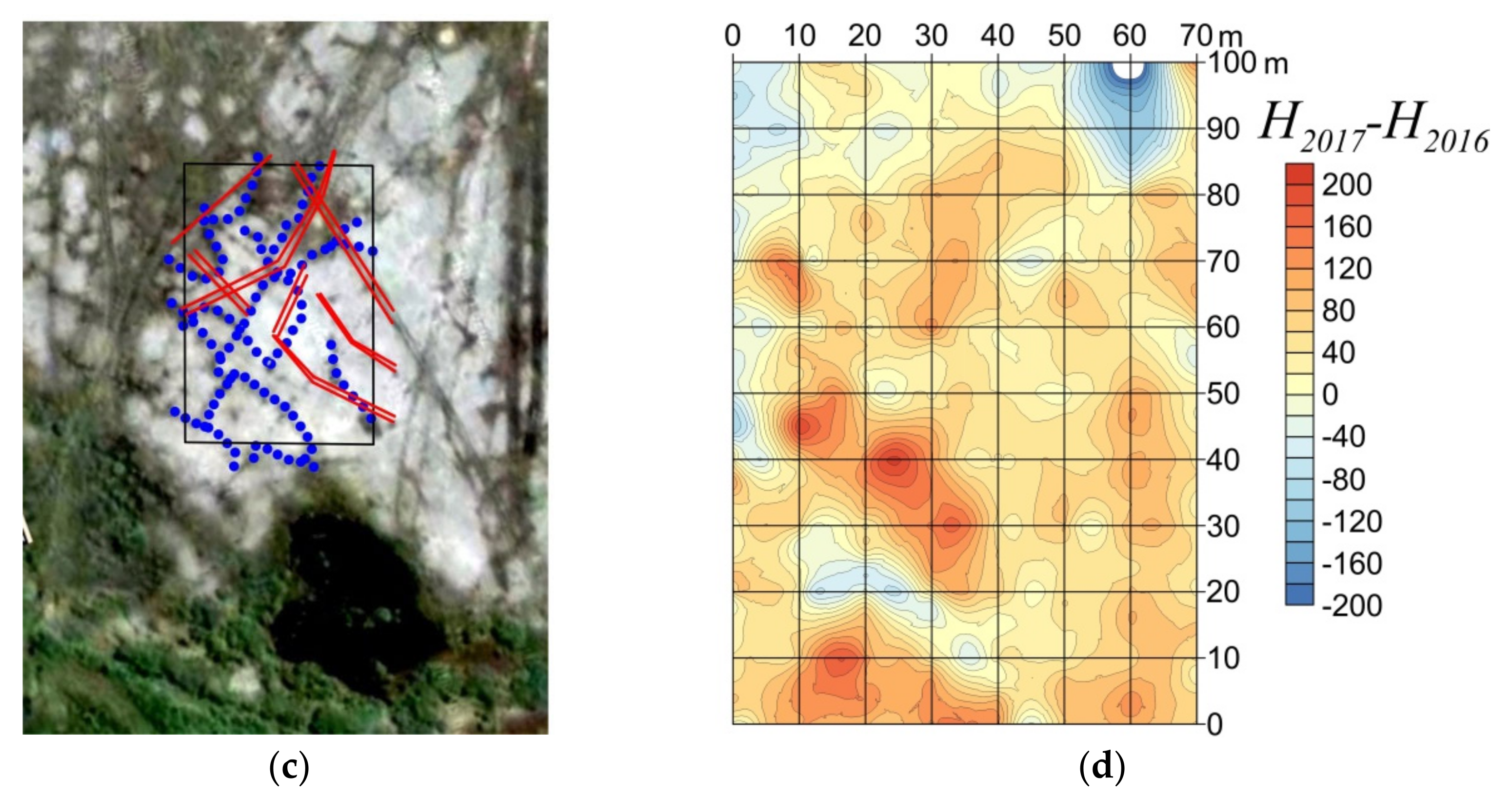
4.1. The Kashin Site (CALM R24A-1)
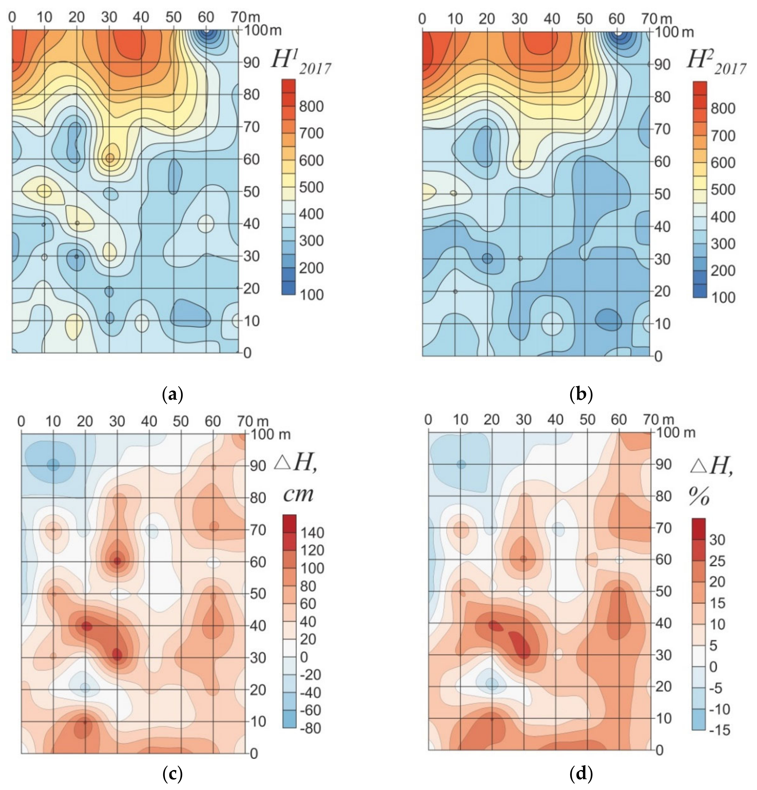
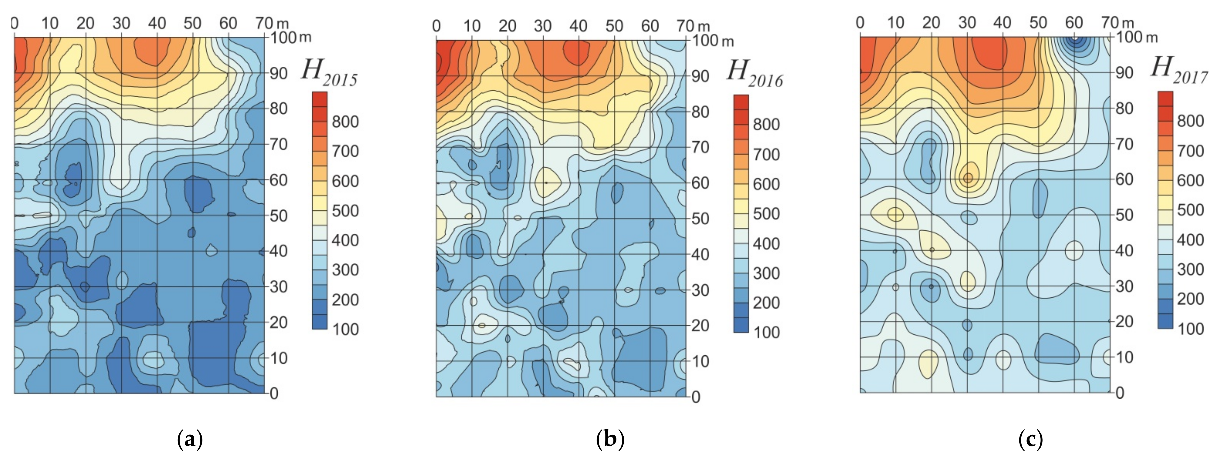
4.2. The Kumzha Site (CALM R24A-2)
5. Discussion
6. Conclusions
Author Contributions
Funding
Conflicts of Interest
References
- Shur, Y.L.; Jorgenson, M.T. Patterns of Permafrost Formation and Degradation in Relation to Climate and Ecosystems. Permafr. Periglac. Process. 2007, 18, 7–19. [Google Scholar] [CrossRef]
- Shur, Y.; Hinkel, K.M.; Nelson, F.E. The transient layer: Implications for geocryology and climate-change science. Permafr. Periglac. Process. 2005, 16, 5–17. [Google Scholar] [CrossRef]
- Pavlov, A.V. Monotoring of Permafrost Zone; Academic Publishing House Geo: Novosibirsk, Russia, 2008; p. 229. (In Russian) [Google Scholar]
- De Pablo, M.A.; Blanco, J.J.; Molina, A.; Ramos, M.; Quesada, A.; Vieira, G. Interannual active layer variability at the Limnopolar Lake CALM site on Byers Peninsula, Livingston Island, Antarctica. Antarct. Sci. 2013, 25, 167–180. [Google Scholar] [CrossRef]
- Romanovsky, V.; Isaksen, K.; Drozdov, D.; Anisimov, O.A.; Instanes, A.; Leibman, M.O.; McGuire, A.D.; Shiklomanov, N.; Smith, S.; Walker, D. Changing permafrost and its impacts. In Snow, Water, Ice and Permafrost in the Arctic (SWIPA) 2017; Arctic Monitoring and Assessment Programme (AMAP): Oslo, Norway, 2017; pp. 65–102. [Google Scholar]
- Biskaborn, B.K.; Smith, S.L.; Noetzli, J.; Matthes, H.; Vieira, G.; Streletskiy, D.A.; Schoeneich, P.; Romanovsky, V.E.; Lewkowicz, A.G.; Abramov, A.; et al. Permafrost is warming at a global scale. Nat. Commun. 2019, 10, 264. [Google Scholar] [CrossRef] [Green Version]
- Brown, J.; Hinkel, K.; Nelson, F. The circumpolar active layer monitoring (CALM) program: Research designs and initial results. Polar Geogr. 2000, 24, 166–258. [Google Scholar] [CrossRef]
- Streletskiy, D.; Shiklomanov, N.; Nelson, F.; Klene, A. Long-term active and ground surface temperature trends: 13 years of observations at Alaskan CALM sites. In Proceedings of the Ninth International Conference on Permafrost, Fairbanks, AK, USA, 28 June–3 July 2008; Volume 29, pp. 1727–1732. [Google Scholar]
- Shiklomanov, N.I.; Streletskiy, D.A.; Nelson, F.E.; Hollister, R.D.; Romanovsky, V.E.; Tweedie, C.E.; Brown, J. Decadal variations of active-layer thickness in moisture controlled landscapes, Barrow, Alaska. J. Geophys. Res. 2010, 115, G00I04. [Google Scholar] [CrossRef]
- Guglielmin, M. Ground Surface Temperature (GST), Active Layer and Permafrost Monitoring in Continental Antarctica. Permafr. Periglac. Process. 2006, 17, 133–143. [Google Scholar] [CrossRef]
- Guglielmin, M.; Fratte, M.D.; Cannone, N. Permafrost warming and vegetation changes in continental Antarctica. Environ. Res. Lett. 2014, 9, 045001. [Google Scholar] [CrossRef] [Green Version]
- Westermann, S.; Wollschlager, U.; Boike, J. Monitoring of active layer dynamics at a permafrost site on Svalbard using multi-channel ground-penetrating radar. Cryosphere 2010, 4, 475–487. [Google Scholar] [CrossRef] [Green Version]
- Sudakova, M.S.; Sadurtdinov, M.R.; Malkova, G.V.; Skvortsov, A.G.; TsarevGro, A.M. Ground penetrating radar applications to permafrost investigations. Kriosf. Zemli 2017, 21, 62–74. [Google Scholar] [CrossRef]
- Vladov, M.L.; Sudakova, M.S. Ground penetrating radar: From physical fundamentals to high-potential applications. In Teaching Guide; GEOS: Moscow, Russia, 2017; p. 240. (In Russian) [Google Scholar]
- Gusmeroli, A.; Liu, L.; Schaefer, K.; Zhang, T.; Schaefer, T.; Grosse, G. Active layer stratigraphy and organic layer thickness at a thermokarst site in Arctic Alaska identified using ground penetrating radar. Arct. Antarct. Alp. Res. 2015, 47, 195–202. [Google Scholar] [CrossRef] [Green Version]
- Hinkel, K.M.; Doolittle, J.A.; Bockheim, J.G.; Nelson, F.E.; Paetzold, R.; Kimble, J.M.; Travis, R. Detection of subsurface permafrost features with ground penetrating radar, Barrow, Alaska. Permafr. Periglac. Process. 2001, 12, 179–190. [Google Scholar] [CrossRef]
- Sadurtdinov, M.R.; Malkova, G.V.; Skvortsov, A.G.; Sudakova, M.S.; Tsarev, A.M. Contemporary state of sporadic permafrost in the Pechora River floodplain (Nenets Autonomous District) from the results of comprehensive geocryological and geophysical studies. In Proceedings of the 5th Russian Conference on Geocryology, Moscow, Russia, 14–17 June 2016; Volume 1, pp. 340–345. (In Russian). [Google Scholar]
- Schwamborn, G.J.; Dix, J.K.; Bull, J.M.; Rachold, V. High-resolution Seismic and Ground Penetrating Radar–Geophysical Profiling of a Thermokarst Lake in the Western Lena Delta, Northern Siberia. Permafr. Periglac. Process. 2002, 1, 259–269. [Google Scholar] [CrossRef] [Green Version]
- Schwamborn, G.; Wagner, D.; Hubberten, H.-W. The use of GPR to detect active layer in young periglacial terrain of Livingston Island, Maritime Antarctica. Near Surf. Geophys. 2008, 6, 327–332. [Google Scholar] [CrossRef] [Green Version]
- Jafarov, E.E.; Parsekian, A.D.; Schaefer, K.; Liu, L.; Chen, A.C.; Panda, S.K.; Zhang, T. Estimating active layer thickness and volumetric water content from ground penetrating radar measurements in Barrow, Alaska. Geosci. Data J. 2017, 4, 72–79. [Google Scholar] [CrossRef]
- Hrbáček, F.; Engel, Z.; Kňažková, M.; Smolíková, J.; Kavan, J. GPR measurement of active layer thickness on CALM-S site, James Ross Island, Antarctic Peninsula. In Proceedings of the 5th European Conference on Permafrost, Chamonix, France, 23 June–1 July 2018; pp. 878–879. [Google Scholar]
- Brosten, T.R.; Bradford, J.H.; McNamara, J.P.; Gooseff, M.N.; Zarnetske, J.P.; Bowden, W.B.; Johnston, M.E. Estimating 3D variation in active-layer thickness beneath arctic streams using ground-penetrating radar. J. Hydrol. 2009, 373, 479–486. [Google Scholar] [CrossRef]
- Wollschlager, U.; Gerhards, H.; Yu, Q.; Roth, K. Multi-channel ground-penetrating radar to explore spatial variations in thaw depth and moisture content in the active layer of a permafrost site. Cryosphere 2010, 4, 269–283. [Google Scholar] [CrossRef] [Green Version]
- Gerhards, H.; Wollschlager, U.; Yu, Q.; Schiwek, P.; Pan, X.; Roth, K. Continuous and simultaneous measurement of reflector depth and average soil-water content with multichannel ground-penetrating radar. Geophysics 2008, 73, J15–J23. [Google Scholar] [CrossRef]
- Brosten, T.R.; Bradford, J.H.; McNamara, J.P.; Zarnetske, J.P.; Bowden, W.; Gooseff, M.N. Profiles of temporal thaw depths beneath two arctic stream typesusing ground-penetrating radar. Permafr. Periglac. Process. 2006, 17, 341–355. [Google Scholar] [CrossRef]
- Melnikov, E.S.; Grechishchev, S.E. (Eds.) Permafrost and Development of Oil-and-Gas Bearing Regions; GEOS: Moscow, Russia, 2002; p. 402. (In Russian) [Google Scholar]
- Malkova, G.V.; Sadurtdinov, M.R.; Skvortsov, A.G.; Tsarev, A.M.; Korostelev, Y.V. Climate-driven changes in permafrost: Impacts on the temperature regime of cryogenic ecosystems in the European North. In Proceedings of the 5th European Conference on Permafrost, Chamonix, France, 23 June–1 July 2018; pp. 583–584. [Google Scholar]
- Vasiliev, A.A.; Drozdov, D.S.; Gravis, A.G.; Malkova, G.V.; Nyland, K.E.; Streletskiy, D.A. Permafrost degradation in the Western Russian Arctic. Environ. Res. Lett. 2020, 15. [Google Scholar] [CrossRef]
- Sadurtdinov, M.R.; Tsarev, A.M.; Skvortsov, A.G.; Sudakova, M.S.; Malkova, G.V. Permafrost mapping within Pechora-river delta (European North) with seismic and ground penetrating radar. In Proceedings of the 5th European Conference on Permafrost, Chamonix, France, 23 June–1 July 2018; pp. 902–903. [Google Scholar]
- Malkova, G.V.; Sadurtdinov, M.R.; Skvortsov, A.G.; Tsarev, A.M. Monitoring of cryogenic geosystems in Nenets Autonomous District, their current state and trends in their changes. In Proceedings of the 3rd Conference Arctic and Subarctic: Mosaic, Contrast, Variability of the Cryosphere, Tyumen, Russia, 2–5 July 2015; Melnikov, V.P., Drozdov, D.S., Eds.; Epoha Publishing House: Novorossiysk, Russia, 2015; pp. 217–221. (In Russian) [Google Scholar]
- Vasiliev, A.A.; Gravis, A.G.; Gubarkov, A.A.; Drozdov, D.S.; Korostelev, Y.V.; Malkova, G.V.; Oblogov, G.E.; Ponomareva, O.E.; Sadurtdinov, M.R.; Streletskaya, I.D.; et al. Permafrost degradation: Results of the long-term geocryological monitoring in the western sector of Russian Arctic. Earth Cryosphere 2020, 24, 15–30, In Russian. [Google Scholar] [CrossRef]
- Forte, E.; Pipan, M. Review of multi offset GPR applications: Data acquisition, processing and analysis. Signal Process. 2017, 132, 210–220. [Google Scholar] [CrossRef]
- Malkova, G.V.; Sadurtdinov, M.R.; Skvortsov, A.G.; Tsarev, A.M. Temperature regime of the upper horizons in disturbed and intact cryogenic landscapes of the European North. In Proceedings of the 5th Russian Conference on Geocryology, Moscow, Russia, 14–17 June 2016; pp. 63–69. (In Russian). [Google Scholar]
- Topp, G.C.; Davis, J.L.; Annan, A.P. Electromagnetic determination of soil water content: Measurements in coaxial transmission lines. Water Resour. Res. 1980, 16, 574–582. [Google Scholar] [CrossRef] [Green Version]


| Year | Kashin | Kumzha |
|---|---|---|
| 2015 | GPR common-offset profiling | GPR common-offset profiling |
| Manual probing of the ALT | Seismic refraction method and common depth point method | |
| Temperature measurements | Temperature measurements | |
| Thermostatic weight method for moisture measurements | ||
| 2016 | GPR common-offset profiling | GPR common-offset profiling |
| Manual probing of the ALT | Seismic refraction method and common depth point method | |
| Temperature measurements | Temperature measurements | |
| 2017 | GPR common-offset profiling | GPR common-offset profiling |
| Manual probing of the ALT | Seismic refraction method and common depth point method | |
| Temperature measurements | Temperature measurements | |
| GPR multifold measurements |
| Time Scale | Average Temperature at the Surface, °C | Field Season | Kashin (CALM R24A-1) | Kumzha (CALM R24A-2) Depth of the Permafrost Table, cm | |
|---|---|---|---|---|---|
| ALT 1, cm | Volumetric Water Content of AL 2, % | ||||
| 14 August 2014–13 August 2015 | −1.6 | August 2015 | 80 | 44 | 350 |
| 14 August 2015–13 August 2016 | −0.2 | August 2016 | 109 | 32 | 380 |
| 14 August 2016–13 August 2017 | −1.6 | August 2017 | 76 | 39 | 400 |
Publisher’s Note: MDPI stays neutral with regard to jurisdictional claims in published maps and institutional affiliations. |
© 2021 by the authors. Licensee MDPI, Basel, Switzerland. This article is an open access article distributed under the terms and conditions of the Creative Commons Attribution (CC BY) license (https://creativecommons.org/licenses/by/4.0/).
Share and Cite
Sudakova, M.; Sadurtdinov, M.; Skvortsov, A.; Tsarev, A.; Malkova, G.; Molokitina, N.; Romanovsky, V. Using Ground Penetrating Radar for Permafrost Monitoring from 2015–2017 at CALM Sites in the Pechora River Delta. Remote Sens. 2021, 13, 3271. https://0-doi-org.brum.beds.ac.uk/10.3390/rs13163271
Sudakova M, Sadurtdinov M, Skvortsov A, Tsarev A, Malkova G, Molokitina N, Romanovsky V. Using Ground Penetrating Radar for Permafrost Monitoring from 2015–2017 at CALM Sites in the Pechora River Delta. Remote Sensing. 2021; 13(16):3271. https://0-doi-org.brum.beds.ac.uk/10.3390/rs13163271
Chicago/Turabian StyleSudakova, Maria, Marat Sadurtdinov, Andrei Skvortsov, Andrei Tsarev, Galina Malkova, Nadezda Molokitina, and Vladimir Romanovsky. 2021. "Using Ground Penetrating Radar for Permafrost Monitoring from 2015–2017 at CALM Sites in the Pechora River Delta" Remote Sensing 13, no. 16: 3271. https://0-doi-org.brum.beds.ac.uk/10.3390/rs13163271