
Comparative Approach of Unmanned Aerial Vehicle Restrictions in Controlled Airspaces


School of Surveying and Built Environment, Faculty of Health, Engineering and Sciences, University of Southern Queensland, Springfield, QLD 4350, Australia
*
Author to whom correspondence should be addressed.
Remote Sens. 2022, 14(4), 822; https://0-doi-org.brum.beds.ac.uk/10.3390/rs14040822
Submission received: 27 December 2021
/
Revised: 27 January 2022
/
Accepted: 7 February 2022
/
Published: 9 February 2022
(This article belongs to the Special Issue New Tools or Trends for Large-Scale Mapping and 3D Modelling)
Abstract
:Recent public discourse regarding unmanned aerial vehicle (UAV) usage and regulation is focused around public privacy and safety. Most authorities have employed key guidelines and licensing procedures for piloting UAVs, however there is marginal consensus amongst regulators and a limited view towards unified procedures. This paper aims to analyze the key challenges that affect the use of UAVs and to determine if the current rules address those challenges. For this purpose: privacy, safety, security, public nuisance and trespass are tested. A set of criteria are developed to perform a comparative analysis against the existing UAV regulations to determine how they are meeting the specified criteria. Within this framework, five countries are selected: Australia, Canada, European Union (EU), United Kingdom (UK) and the United States of America (USA), with usage data and length of time between regulatory reviews ensuring any analysis is realized on updated protocols. The regulations of each country are then compared against the developed criteria. The findings show there are shortfalls with the majority of regulations failing to meet some criteria and the results confirm that key issues fail to be addressed. Finally, recommendations are suggested for filling the gaps in the regulations.
1. Introduction
The use of commercial and private unmanned aerial vehicles (UAVs) is becoming increasingly ubiquitous. In 2018, the number of remote pilot licenses in Australia had increased by 53% over the previous year [1]. In 2021, approximately 22,000 remote pilot licenses had been issued, averaging 300 new licenses per month [1].
With the increase in the number of UAVs, there comes a greater need for regulation to ensure the safety and privacy of the public. On 19 December 2018, two drones were flown close to the Gatwick Airport perimeter resulting in the airport being shut down for 33 h and causing over 140,000 travelers to be affected [2]. The incident was the first time a major airport was shut down due to a drone incursion and demonstrated how it could disrupt the operations of a major airport and air traffic routes. The case remains unsolved, but the incident focused political attention on drone operations.
As politicians and regulators aim to catch up with the increasing number of UAVs, researchers urge caution should be applied as regulation can both promote and suppress innovation [3], as UAV use and development needs surety to continue to be practicable. Within the European market, the two most prevalent issues regarding regulation are security and safety considerations [4]. However, as Europe contains multiple independent countries with non-uniform regulations, over-regulation can be the principal hurdle to surmount. In certain countries, the regulatory limitations imposed on the commercialization of the technology were “notorious” [5].
Public discourse regarding UAV usage and regulation centers around public privacy and safety, which regulations aim to address [3,6,7]. Whilst most jurisdictions have implemented key guidelines and licensing procedures for piloting UAVs, there is marginal consensus amongst regulatory bodies and a limited view towards a universal standard [8]. Identical UAVs operating in identical flight circumstances are bound by different guidelines and regulations depending on the country of operation. These regulations can differ significantly for flying height, flying proximity to people/buildings and weight classes. These regulatory differences add additional complexities for a person to navigate when planning and flying UAVs, whether it’s for commercial or private use. Whilst UAV operators in Australia are bound by a single regulator [9], a person in the European Union (EU) could have to contend with and be well versed in a multitude of regulations encompassing numerous jurisdictions [10].
This paper aims to compare existing UAV regulations across a number of diverse jurisdictions to determine the key problems and issues that arise from the use of UAVs and develop a set of criteria to attempt to resolve problems identified and determine if existing regulations address these issues. By identifying if the key issues, such as privacy, safety and security are being addressed, recommendations will be made to mitigate any discrepancies found in the regulations. To conclude, the objectives of this research are as follows:
- Determine the similarities and differences in existing regulations;
- Define the key problems that arise from the use of UAVs;
- Develop a set of criteria to resolve the key problems;
- Using the criteria, examine if present restrictions address the key issues;
- Provide recommendations addressing any shortfalls in the regulations.
Although this project seeks to research UAV regulations across a variety of jurisdictions, due to time and scope constraints only a selection of regulations have been analyzed. These are chosen based on UAV usage numbers, existing established UAV regulations and length of time between regulatory reviews. Countries with limited regulations or limited usage data available are excluded from the analysis. Other limitations are that although there is significant data available relating to the employment of UAVs by the military, the primary emphasis of this paper is on the commercial and private/recreational use of UAVs. Numerous countries are investigating the need for changes to their UAV guidelines with several jurisdictions in the process of transitioning to new regulations.
2. Literature Review
In this section, five points are investigated among the UAV guidelines which are privacy, safety, security, public nuisance and trespass.
2.1. Privacy
The primary concern with the increased use and development of UAVs is what Finn and Wright [11] describe as the potential for UAVs to infringe on the ethical and privacy rights of people as a threat to civil liberties. Nelson et al. [12] use Floridi’s notions of privacy to ascribe tangibility to privacy and define private space as areas “free from sensory interference or intrusion, void of unwarranted interruptions”, such as sound, touch and vision. Clarke [13] links the issue of privacy to UAVs and surveillance through his five dimensions of privacy (person, data, behavior, communication, personal experience), of which he attributes behavioral privacy and privacy of personal experience as being the most important as they incorporate “the interests that are most directly impinged upon by drone-base surveillance”. Finn et al. [14] further defines Clarkes behavioral privacy as protection against disclosure of sensitive information, such as religious practices, sexual practices or political activities.
Australia’s privacy regime is often out of date with current technology [15]. In this context, the question of the ability for UAVs to enter private property, travel unnoticed and record or live stream images and sounds creates significant opportunities for privacy breaches to enter the public domain. The privacy question comes down to how it will be regulated and finding the line between regulation that achieves the technological benefits without removing the right of recourse and remedy if an individuals’ privacy has been invaded [15]. However, existing laws are either outdated or are lacking in definition and provide remedy only in limited circumstances [13].
2.2. Safety
Sanz et al. [7] define safety as the state in which the system is not in danger or at risk, free of injuries or losses. Clothier and Walker [16] state that for routine UAV procedures to be combined into the civilian airspace, UAV developers, operators and regulators must prove that the safety of UAVs is at a minimum, equal to conventionally piloted aircraft. In this context, Clarke and Moses [17] observe that there are challenges to achieving this standard due to low costs, limited safety features and the growing volume of UAVs that there will unavoidably be low standards of pilot performance and the usual high costs in detection, investigation and defining responsibility. There are three main factors that play a major role in UAV safety as follows:
Collision–Aircraft: Prior to existing regulations, both commercial and private UAV flights were able to fly close to airports, secure facilities and overpopulated areas [18]. This initial freedom posed a serious threat to safety and security. An increasing number of International Civil Aviation Organization (ICAO) members were becoming concerned with UAVs flying within close proximity to commercial aircraft which was proving hazardous to commercial aircraft [19]. Over half of all incidences concerning UAVs reported to ATSB were close encounters involving manned aircraft and half of those again involved high-capacity air transport aircraft [20]. ATSB [20] outlines a near encounter as when a UAV interrupts or is seen in the vicinity of another aircraft. Furthermore, they found that in 8% of cases, engine ingestion can be expected, and it is likely that when compared with bird ingestion, engine damage and engine shutdown is expected to be higher. This increase in damage was explained by UAVs being heavier and more rigid than the skeletal structure of a bird. At this stage, IATA [21] emphasizes that manned aircraft encounters with UAVs are the top safety risk to the aviation industry;
Collision–Terrain: Terrain collisions accounted for 26% of all reported UAV accidents between 2012 and 2017, with almost half of these events occurring from loss of control of the aircraft [20]. The collision with the terrain had the second highest incident occurrence out of all incidents. Of these accidents, 84% resulted in the UAV being significantly damaged or destroyed [20]. A terrain collision can occur when the operator fails to maintain a visual line of sight (VLOS) with the UAV and is unable to account for changes in elevation in the terrain or obstacles, such as trees and buildings;
Impact: The issue of direct physical UAV impact gives rise to potential harm to public safety. There are also indirect threats where impact can lead to fire or explosion [17]. Magister [22] links UAV design shape and injury biomechanics relating to the blunt ballistic impact of UAVs and found that the severity of injury in small UAVs (<15 kg) when operating at minimal airspeed was “less than serious” when contacted with a blunt section of the UAV. However, CASA [23] modeled human injury potential from impacts of small unmanned aircraft and determined that an abbreviated injury scale (AIS) of 3 as the highest acceptable injury allowed. They found UAV mass and velocity as well as the diameter of the UAV determined how severe the injury would be. They noted that for a 2 kg UAV travelling at 10 m/s for a head impact, it would cause a fractured skull when impacting with the flat side of the UAV. In a total loss of control scenario where the UAV falls, reaching its terminal velocity, any impact at such high speeds (> 30 m/s) would cause unacceptably severe injuries regardless of the weight of the UAV [23]. Consequently, certain design and operational criteria may reduce the risk of injury.
2.3. Security
The question of security relating to UAVs can be summarized into two major points:
Loss of Control: CASA [24] states that loss of control of a UAV may be sudden and recovery very difficult even for experienced remote pilots. Loss of control may happen through several means: hijacking, global navigation satellite system (GNSS) jamming and spoofing, hardware/software malfunction, electromagnetic interference, exceeding UAV limitations, malicious software and user error. In this context, several examples can be cited regarding loss of control. Shepard et al. [25] refer to an incident when a Central Intelligence Agency (CIA) surveillance drone was captured by Iranian forces by jamming the UAVs communication link forcing the UAV into autopilot mode using a predetermined global positioning system (GPS) guidance to return to its base in Afghanistan. The UAV was able to be commandeered by spoofing the UAV with new GPS coordinates causing it to land in Iranian territory. Commercial UAVs on the market today are open to hijacking or hacking by electronic interference. Skyjack is a UAV created by Samy Kamkar that will find vulnerable UAVs in the air, discover an open network and change its service set identifier (SSID), which eliminates any connected users [26]. Zhi et al. [27] discuss a hijack method that involves GPS spoofing by broadcasting a false location and time with a universal software radio peripheral (USRP), which leads to control over the target UAV. GPS signals are susceptible to interference (both intentional and unintentional) due to the low power they have at the earth’s surface [26]. Arteaga et al. [26] note that radio-frequency communication can be exploited. They discuss a process called flooding where an adversary floods the wireless fidelity (WIFI) channel with information interrupting the communication on the channel. This is commonly referred to as denial of service (DoS). Electromagnetic interference may cause a loss of connection. In 2018, a UAV collided with a cruise ship near Fort Hill Wharf, Northern Territory, Australia, when the UAV lost signal. The UAV operator started return home procedures when the UAV deviated from its path and collided with the ship and was destroyed [20]. Finally, Maldrone is software that produces a backdoor in the targeted UAV software and waits for a reverse TCP connection, which once received allows an attacker to gain control over the now infected UAV [26];
Anonymity: UAVs can be purchased and flown anonymously. This creates security problems as it is difficult to track and identify an offending UAV pilot that breaks the law. Therefore, automatic dependent surveillance broadcast (ADS-B) transponders are used on aircraft and obtain their position via GNSS. This position is then broadcast to control towers and other aircraft which helps maintain safe self-separation while in the air. A leading drone manufacturer is installing ADS-B receivers in all drones above 250 g [28]. Another parts manufacturer has developed an ADS-B beacon measuring 50 mm × 50 mm and weighing 50 g. This allows it to be placed on smaller UAVs allowing their position to be tracked.
2.4. Public Nuisance
Noise and nuisance were found to be the primary issues regarding public nuisance and UAVs:
Noise: Noise causing environmental harm/nuisance negatively affects human health and wellbeing by interfering with recreational activities, sleep and relaxation [29]. UAVs are not quiet in their operation. Christian and Cabell [30] found that participants subjected to psychoacoustic testing had a systemic variance between the annoyance response produced by the noise of the UAVs and that of the road vehicles. Intaratep et al. [31] analyzed the acoustic properties of a popular brand of quadcopter UAV and found that the sound intensity at maximum thrust (80 dB) is equivalent to a freight train passing 15 m away. At this level, it may cause annoyance in populated areas subject to high drone usage. Christiansen et al. [32] measured the noise level of two multi-rotor UAVs at varying heights above and below the water to determine the negative impact on UAVs flying over marine animals. A mean value measured at a height of 10 m for each UAV was 80 and 81 dB re 20 μPa for the in-air recordings and 95 and 101 dB re 1 μPa for the underwater recordings. However, decibels measured in the air do not directly link to decibels measured underwater. Christiansen et al. [32] observed that the in-air dB values of UAVs flying at low altitudes will most likely have a disturbing effect on sea otters and pinnipeds when they were on land or with their heads protruded from the water;
Nuisance: During the 2017 fire season in Victoria, Australia, there were four instances where amateur UAV operators had engaged in nuisance behavior during fire suppression activities and standard operating procedure when unauthorized UAVs are flying over emergency areas is to ground the aerial fleet [19]. Pomeroy et al. [33] confirm that flights over both Gray and Harbor seals were variable, with individual variation amongst seals of the same species. Gray seals generally changed behavior from alert to moving at altitudes from 10–50 m and a lateral distance of 15 to 210 m whilst Harbor seals showed little reaction at a 30 m altitude. Nelson et al. [12] posit that as UAVs become more ubiquitous and people become more familiar with them, a decrease in concern for privacy will occur and the issues of UAV-bystander interaction will more likely shift towards nuisance rather than privacy.
2.5. Trespass
In Australia, New South Wales farmers had limited legal remedy when they’ve caught UAVs trespassing on their property [19]. Farmers suggest punitive monetary penalties for the lack of due diligence and potential harm caused by UAV operators. Additionally discussed by the committee is the use of geofencing to prevent access to private property by limiting the distance the UAV could travel from its pilot thus reducing the risk of trespass and privacy infringement. New South Wales, South Australian, Tasmanian, Victorian and Western Australian legislation states that there is no trespass or nuisance by aircraft flying over the property at a reasonable height as long as air navigation regulations are adhered to [34].
3. Methodology
To achieve our stated objectives, we pursued the following approach: Determine the countries for analysis, extract the UAV regulations from the selected countries, develop criteria from the identified issues found in the regulations and the examination of existing regulations compared against the prescribed issues using the developed criteria. The first three steps are detailed in this Section with the remaining step applied in Section 4.
3.1. Country Selection
To select five representative countries to analyze the UAV regulations, two criteria are used. The first one is the number of users and ascertains if there is a strong user base. The premise behind this question is that if a country has a large number of users, then the regulations will be robust as there would be a greater opportunity for issues to present themselves and be addressed. The second criterion determines if there has been recent UAV regulatory reform. This criterion ensures that any comparison performed will be realized on regulations that have been updated in parallel with any technological developments. Consequently, greater consideration is given to countries that are in the process of amending or transitioning to new regulations. In this context, three research segments were identified to direct how the user base will be determined which are:
- Countries that are acknowledged in prior research and market analysis;
- Estimated numbers of UAVs;
- Estimated users including reported licensed and/or certified operators.
From Table 1, it can be seen that Australia, Canada and USA are mentioned across the three references, with China and UK mentioned twice. The USA have the largest market size, is the most active country online and have the most documented flight operations per country. China and France follow in second and third place, respectively [36].
Concerning the estimated numbers of UAVs, Figure 1 illustrates the estimated numbers of UAVs of counties where UAVs are widespread [4]. The EU, USA, Germany, Canada, China and Australia have the largest documented numbers of UAVs reported.
An overview of the estimated numbers of UAVs and recreational/commercial users from the most commonly mentioned countries from the previous studies is detailed below:
- Australia—estimated 100,000 and 150,000 UAVs in the country and estimate of 50,000 recreational users and 1720 commercial users [9];
- Brazil—34,000 civil UAS registered with 65% being for recreational purposes and 35% for commercial, estimated actual total numbers 100,000 [37];
- Canada—337,468 UAVs in Canada 74% recreational and 26% commercial. 12% is the ratio between manned aircraft pilots between the US and Canada. The same ratio was used to compare the number of UAVs in the US to estimate the number of UAVs in Canada [38]. However, this number was revised down in 2018 to 193,500 estimated UAVs being flown in Canada by 140,800 operators [39];
- China—24,407 certificates to fly were administered at the end on 2017, however certification is only needed if the UAV weighs over 7 kg [40];
- European Union (macro-class)—1–1.5 million leisure UAVs and 10,000 commercial UAVs [41];
- France—7471 referenced operators and 13,647 referenced UAVs in December 2018 [42];
- Germany—500,000 drones in Germany. 455,000 are for private use and 19,000 for commercial use. Over 10,000 employed in the drone industry [36];
- India—A rough calculation of 40,000 UAVs, predominately civilian, but including military and law enforcement UAVs as well [43];
- United States—900,000 registered owners and 1.25 million estimated UAVs [44].
Finally, the estimated numbers of licensed operators are shown in Figure 2. The USA has the highest number of users by far, followed by the UK and Canada of the countries mentioned in Figure 2. The sources of statistics of Figure 2 are presented in Table 2. At this stage, the regulations that have not been amended or revised in the last three years will be excluded from the analysis. This ensures that comparisons are performed against regulations that are attempting to address recent developments in technology and user requirements.
For further analysis and by intersecting the data shown in Table 1, Figure 1 and Figure 2, the following five countries are selected:
- Australia—Large numbers of UAVs with a large user base and regulations recently updated;
- Canada—Large numbers of UAVs with a large user base and regulations recently updated;
- European Union—Currently in regulatory transition, encompasses a large population and numerous jurisdictions;
- United Kingdom—Large numbers of UAVs with a large user base and regulations recently updated;
- United States of America—The largest market of UAV operators with regulations recently updated.
3.2. UAV Regulations in Selected Countries
UAV regulations for the five chosen countries are summarized (see Appendix A). The primary source of information for the regulations is the respective government bodies which are available online. These regulations are collated by year of inception. This ensures that comparisons are performed against regulations that are attempting to address recent developments in technology and user requirements. The new European regulations will be included in the comparison because no other regulation will encompass such a wide variety of jurisdictions and a large population base.
At this stage, it is important to note that there is considerable variety of UAV restrictions between the selected countries, e.g., in the context of UAV security regulations in controlled airspaces, the regulations have stipulated guidelines regarding UAV usage near controlled or restricted airspaces. The shape of the restricted zones generally varies significantly across jurisdictions from radial to shapes incorporating overlays of circles, stadiums (oval shaped) and polygons with straight edges to encompass flight paths. For more details see Appendix A.
3.3. Comparison Criteria Development
Section 2 identified privacy, safety, security, public nuisance and trespass as the overarching challenges with UAVs use. Privacy proved to be one of the most researched issues with the primary concern being the ability for UAVs to infringe on people’s privacy rights. Although no author outlined guidelines allowing for the practical avoidance of privacy infringement, details could be inferred from the inherent nature for UAVs to “enter private property, travel unnoticed and record or live stream images and sounds create significant opportunities for privacy breaches” [15].
Research surrounding UAV safety of course proved to be munificent in highlighting numerous challenges to UAV flight. Lack of operator knowledge was demonstrated to be the primary cause of most reported near encounters with the risk of collision being the consequence of this lack of knowledge with over half of near encounters involving UAVs. Researchers established that visual line of sight was difficult to quantify and demonstrated a formula enabling maximum VLOS to be determined using the width of the UAV whilst being predicated on perfect vision in perfect visibility. Impact could be tied in with collision but was separated as research was primarily focused on UAV design and specifications, such as weight and flight speed instead of operator interference.
Security issues were at the forefront of the research with terrorism and loss of control being of primary concerns. There are numerous ways an operator can lose control of a UAV with user error and pushing the aircraft beyond its operational limits being most likely, whilst others can be put down to a technologically sophisticated adversary or factors beyond control of the operator. Anonymity was discussed with the main risk being UAVs purchased and flown without the need for registration. However, major manufacturers are stepping in with hardware developments, such as ADS-B beacons being installed on UAVs above a certain weight class and now most manufacturers require registration prior to first flight.
Regarding public nuisance, UAV noise was a cause for concern with research stating that decibel readings taken close to the UAV were equivalent to a freight train passing 15 m away. NASA concluded that UAVs were between slightly and moderately annoying even up to 100 m away. Nuisance behavior created the greatest problems causing the cessation of emergency operations when UAV operators were flying within proximity to water bombers during firefighting operations or near rescue helicopters hindering rescues.
The following criteria were developed from the issues identified during the literature review (Section 2). The purpose of the criteria below is to interrogate the regulations and determine if and how they are addressing those issues:
- Privacy: The regulations shall address the privacy concerns of the general public or provide guidelines to reduce the risk of infringing on a person’s right to privacy;
- Safety: Four major points are considered regarding the issue of safety. First, operators shall possess a minimum level of knowledge to operate the UAV safely to reduce the risk of injury to people or property. Knowledge could be demonstrated in the form of an online examination, accreditation or a pilot’s certificate. Second, the regulations will contain guidelines reducing the risk of collision including onboard collision sensors and alarms. Third, maximum VLOS shall be defined as visual confirmation of the UAV with the naked eye but not further than 400 m. This value can be calculated from Equation (1) [18].where W is the UAV width of 350 mm and is the visual acuity of the pilot of 0.0167°.
Fourth, the regulations will contain limitations on the design of the UAV and the flight parameters reducing the risk of harm to people from direct impact. Weight classes and flying speed limitations shall be implemented:
- Security: The regulations will stipulate guidelines including limitations reducing the risk of losing control of the UAV. Furthermore, regulations have ensured that UAVs and operators are identifiable and have limited the ability for UAVs to be flown anonymously;
- Public Nuisance: The regulations will implement guidelines addressing the issue of noise pollution from the use of UAVs, such as a maximum decibel value from an environmental agency or placing limitations on flying times and distances. Moreover, the regulations will implement guidelines reducing the risk of nuisance behavior and specifically mention avoiding emergency personnel or placing limitations on flying times and distances;
- Trespass: The regulations will implement limitations and guidelines preventing the act of trespass;
In the next section, the regulations of the selected countries will be directly compared with the developed criteria by simple comparative analysis. The regulation relevant to each subheading of the designed criteria will be assessed against said criteria.
4. Results
This section aims to present the results of the comparison of the criteria formed from the issues identified in Section 3.3 and the regulations of the selected countries in Section 3.1. For each one of the selected countries, the five identified criteria will be analyzed. At this stage, in the context of safety criterion, four points will be emphasized which are a minimum level of knowledge, collision avoidance, VLOS and impact, whereas in the security criterion, two points will be emphasized which are the loss of control and anonymity. Finally, in the public nuisance criterion, noise and nuisance behavior will be investigated. Consequently, it will be determined if the regulations are meeting the developed criteria, and if so, it will be highlighted how by focusing on the differences and similarities between the regulations and the criteria.
4.1. Australia
Privacy: CASA [24] stipulates that it does not consider privacy concerns when issuing approvals. However, it does recommend that operators include privacy provisions in their operations manuals. Recreational users are advised to respect personal privacy and not record or photograph people without their consent. There are no guidelines within [41] Part 101 Unmanned Aircraft and Rockets detailing how pilots can reduce the risk of privacy violation;
Safety: Drone accreditation is needed if pilots are flying for fun (recreational users), flying over their own land or flying a UAV weighing less than 2 kg. Commercial users need a remotely piloted aircraft operator’s certificate (ReOC) as well as a remote pilot’s license (RePL) if flying outside the drone safety regulations or fly UAVs weighing more than 2 kg. There are no guidelines within [45] Part 101 Unmanned Aircraft and Rockets stipulating the need for collision sensors or alarms onboard UAVs. There are defined operational limits, such as maximum flying heights and distances to aerodromes. However, collision is only mentioned within the definition of operated within VLOS, which states that “a person has to be able to see the aircraft to uphold the operator’s separation and collision avoidance responsibilities”. Advisory circulars released by CASA guide how the regulations should be interpreted, e.g., all UAVs operating in the non-excluded (included) category should be painted for maximum visibility including collision avoidance lights such as strobe lights (101-01 v2.1 [46]). If ADS-B transponders are fitted, they should meet the required standards and be turned on.
Concerning the VLOS, subpart 101.074 (3) [46] of the regulations provides this definition of VLOS: “An unmanned aircraft is being operated within the VLOS of the person operating the aircraft if the person can continually see, orient and navigate the aircraft to meet the person’s separation and collision dodge responsibilities, with or without corrective lenses, but without the use of binoculars, a telescope or other similar device” [46]. The definition provided by CASA gives guidance on how an operator would define the VLOS to their aircraft. It places the onus on the operator to determine the maximum VLOS without providing a quantitative value which would reduce the risk of operators flying outside their visual limits.
Finally, recreational users are limited to UAVs that weigh up to 2 kg. Commercial operators are bound by the same weight restrictions unless they hold a remote pilot’s license and operate under a remotely piloted aircraft operators’ certificate. The regulations provide no speed limitations on UAV flights and there is no mention of design parameters that would reduce the risk of harm from direct impact;
Security: Concerning the loss of control, there are no guidelines specifying procedures on mitigating the risk of losing control of a UAV ([47] Part 101 Unmanned aircraft and rockets). However, a brief overview of procedures for loss of control in an extended VLOS (EVLOS) flight is given [47]. The operator’s procedures should ensure that the pilot can re-establish control or end the flight without causing a hazard to life or property [47]. Ref. [47] (AC 101-01 v2.1) discusses how losing control can be harmful to the public. It also details how mission plans should have procedures relating to how emergencies, such as loss of control would be handled by the operator and provide examples of how fail-safe devices would reduce the injury to bystanders. CASA also notes that data links between the UAV and the operator should be monitored in real-time with warnings given in case of failure.
Concerning anonymity, CASA is introducing registration for all UAVs flown for both commercial and recreational purposes. The primary purpose of the registration initiative is to ensure that people fly their UAVs responsibly and safely [1]. Apart from the ADS-B requirements for larger UAVs, no other de-anonymizing requirement was found in the regulations;
Public Nuisance: There are no guidelines within [45] specifying procedures on reducing the issue of noise pollution generated by UAVs. Both 101-01 v2.1 and 101-10 v1.3 in [46] and confirm that UAV operators are bound by local noise abatement laws. These include restrictions on altitude, flight path and the time of day of flights. Additionally, the regulations state that unless additional flight permissions are obtained, the operational hours for flying a UAV are during daylight hours as flights must be within VLOS.
Ref. [45] Part 101 unmanned aircraft and rockets specify that UAVs must not be flown over an emergency operation or public safety event without the approval of the person in charge. As noted above, the risk of nuisance behavior at night is reduced as most UAV operators can only fly during daylight hours as flights must remain within VLOS;
Trespass: There are no guidelines within [45] Part 101 Unmanned Aircraft and Rockets addressing the issue of trespass.
4.2. Canada
Privacy: Although not preserved within the Canadian Aviation Regulations [48], Transport Canada [49] provides clear privacy guidelines for both recreational and commercial UAV users. Operators are directed to a dedicated online resource specifically detailing the privacy guidelines for flying UAVs. This resource discusses that although Canadas’s privacy regulations do not specifically reference UAVs, the privacy laws in Canada do apply to information that could be collected, such as video and pictures. Recreational users must abide by the previously mentioned five privacy principles, while commercial operators are bound by the Personal Information Protection and Electronic Documents Act (PIPEDA). PIPEDA applies to all businesses within Canada and ensures that consent is obtained when collecting personal information and that the information is handled with a high degree of professionalism;
Safety: To be allowed to fly a UAV in Canada with a MTOW between 250 g and 25 kg, recreational and commercial operators must obtain a pilot certificate with either basic or advanced endorsement. Concerning collision, general operating and flight rules specifically mentions the risk of collision and provides procedures and guidelines to reduce its risk. Pilots should not increase the risk of collisions by flying close to other aircraft (901.18 [48]). Take-off and landing sites must be suitable for the operation and that there is no risk of collision with aircraft, bystanders or obstacles (901.33 [48]) and if the risk of collision becomes too great then operators must cease any flights immediately (901.49 [48]).
Concerning the VLOS, (900.01 [48]) provides the following definition under the regulation for VLOS means unaided visual contact at all times with a remotely piloted aircraft that is adequate to be able to preserve control of the aircraft, know its location and be able to scan the airspace in which it is functioning to perform the detect and avoid functions in regard to other aircraft or objects”. No pre-defined distance is given regarding the maximum visual line of sight. The responsibility is placed on the pilot to ensure that they believe they have control of the UAV at all times.
Finally, the main operating categories being basic and advanced have weight limitations on the types of UAVs that can be flown. UAVs weighing up to 25 kg can be flown providing the operators adhere to the regulations under each of those categories. Drones weighing over 25 kg can be flown but need special permission from Transport Canada [49] in the form of a Special Flight Operations Certificate. The regulations provide no speed limitations on UAV flights and there is no mention of design parameters that would reduce the risk of harm from direct impact;
Security: Loss of control is termed a “fly-away” within the regulations and defined as a loss of the command-and-control link between the operator and the UAV in which the operator is unable to control the UAV. An operator should not pilot a UAV unless they have procedures to handle emergencies, such as loss of the command-and-control link or a fly-away (901.23 (1) [48]). Pilots should cease operations if the UAV becomes uncontrollable (901.49 (1)(f) [48]). Minimal advice can be found within the regulations regarding how an operator would limit the risk of a fly-away.
Concerning anonymity, all UAVs weighing from 250 g and up to and including 25 kg need to be registered with Transport Canada. The operator’s name and address, date of birth, purchase date, make, model, serial number, weight and type of UAV are recorded against a registration number. This registration number must be marked on the UAV with a permanent marker, permanent label or engraving. There are no other real-time identification requirements within the regulations;
Public Nuisance: First, there are no guidelines within [48] addressing the issue of noise pollution from the use of UAVs. Compounding the issue, night flights are permitted as well providing the UAV has position lights enabling it to be seen during the night either with or without night vision goggles worn by the operator (901.39 (1) [48]).
Second, A UAV must not be flown over or within an emergency security perimeter established by a public authority responding to an emergency (901.12 (1) [48]). As noted above, nuisance behavior is not limited to daylight hours as the regulations allow for UAV flights at night as VLOS can be established using positioning lights;
Trespass: There are no guidelines within [48] addressing the issue of trespass.
4.3. European Union
Privacy: Regulations have been established to address the risk of privacy infringement [50]. One of the main aims of the regulations is to mitigate the hazards around the protection of personal data and privacy [50]. If a UAV is capable of capturing personal data via a sensor (e.g., camera) attached to the UAV then the operator must be registered within a Member State (Article 14 (5)(a)(ii) [51]). A competent authority is tasked with maintaining a registration system for operators whose operations present a risk to privacy and personal data protection (Article 18 (m) [51]). A statement is required from the operator confirming that the planned operation will comply with all EU and national rules, in particular how it will address privacy and data protection (Article 12 (1)(c) [51]). Privacy is defined as one of the deciding factors when determining geographical areas where UAVs can operate (Article 15 (1) [51]). Knowledge regarding privacy and data protection is to be demonstrated via an examination delivered by a competent authority (UAS.OPEN.020 (4)(b) [51]). These regulations are aimed towards operator awareness and education rather than hard guidelines. Operators must demonstrate knowledge regarding privacy issues and the regulations have been constructed to reduce the risk of privacy breaches.
Safety: All operators wishing to operate UAVs with CE markings from C1 to C4 must pass an online exam. If operators want to fly close to bystanders, an additional theoretical exam must be taken and delivered by a recognized entity. Concerning collision, the only guideline in place within the regulations for reducing the risk of collision is (UAS.OPEN.060 (2) [50]). During the flight, the remote pilot shall keep the UAV in VLOS to reduce the risk of collision with manned aircraft with the flight being discontinued if there is an increase risk to aircraft, people, animals, environment or property. Any UAV operations in the certified category must abide by (no 1332/2011 [51]), which define operating procedures for airborne collision avoidance. These regulations include the need for airborne collision avoidance systems (AUR.ACAS.1005 (3) [51]) and what to do when they sound a collision alarm (AUR.ACAS.2005 (1) (2) [50]). These regulations, however, only apply to the certified category of flight operations which are deemed high risk and form a small portion of total flights. The European Union has defined five classes of UAVs based upon their weight (C0, C1, C2, C3, C4) with the C1, C2 and C3 class UAVs to be equipped with a geo-awareness system that allows for uploading and updating airspace limitations, warning alerts to the remote pilot of imminent airspace breach detections and also be able to alert the operator if the geo-awareness system is not functioning properly (Part 2–5 [52]). The C1, C2 and C3 UAVs are to be equipped with lights with the stated purpose being to aid in controlling the UAV and for increased visibility at night to able people to distinguish between manned aircraft and the UAV.
Concerning the VLOS, it is described as: “a type of UAS operation in which, the remote pilot is able to maintain continuous unaided visual contact with the unmanned aircraft, allowing the remote pilot to control the flight path of the unmanned aircraft in relation to other aircraft, people and obstacles for the purpose of avoiding collisions” (article 2 [51]). No pre-defined distance is given regarding the maximum VLOS. During a flight, the pilot shall maintain VLOS and consistently scan the surrounding airspace to avoid the risk of collision (UAS.OPEN.060 (2) [51]).
The C0 class UAV, the maximum take-off mass (MTOM) is less than 250 g and a maximum speed of 19 m/s (part 1 [52]). A C0 class UAV has to be designed to minimize damage to people from impact, such as no sharp corners and design limits on propellers to reduce injury from the fan blades. A C1 class UAV is to be made from materials and have physical and performance specifications that if an impact at its maximum speed (terminal velocity) to the human head exerts less than 80 J or has an MTOM of less than 900 g and a maximum speed limit of 19 m/s (Part 2 (1) [52]). A C2 class UAV must weigh less than 4 kg and by the nature of its design, limit the injury caused to people from impact by avoiding sharp edges and reducing the damage that can be caused by fan blades (Part 3 [49]). A C3 class UAV must be under 25 kg with Part 4 limiting the physical dimensions of the UAV to less than 3 m (Part 4 and 5 [52]);
Security: Concerning loss of control, guidelines are provided for how UAV manufacturers can provide solutions to mitigating the risk of losing control of the UAV unexpectedly (parts 1–5 [49]). The regulations stipulate that for classes C0–C4, the manufacturer of the UAV must place on the market a manual of operations that states how the UAV will behave during a loss of data link. There is also a requirement under each of the classes that when a loss of data link has occurred, there will be a reliable and predictable way to recover the data link or the flight will be terminated.
Concerning anonymity, the Commission Delegated Regulations [52] have provided clear procedures to reduce the possibility of operators flying UAVs anonymously. All UAVs with an MTOM of more than 250 g must have a direct remote identification system equipped on the UAV. Direct remote identification is defined as a system that broadcasts information locally about the UAV, such as the operator details and UAV specifications, without the need to physically access aircraft (Article 2 [51]). A UAV shall have a direct remote identification system that will periodically broadcast from the UAV, in real-time during the flight, on an open transmission protocol that can be received by existing mobile devices in broadcast range, the following information: operator registration number, unique physical serial number of the UAV, the geographical position, height above the surface and take-off point, the route that was taken by the UAV and the geographical position of the UAV [52];
Public Nuisance: The Commission Delegated Regulations state it is important to limit the noise emissions generated by UAVs to the greatest possible extent in order to provide the highest level of environmental protection [52]. The Noise Test Code establishes procedures for manufacturers to measure the noise generated from their UAVs, including microphone placement and operating conditions during the test (Part 13 [52]). It details the maximum sound power levels per class of UAV with those levels reducing over the course of two and four years to give manufacturers a grace period to adjust their UAV designs (Part 15 [52]). All operators are required to plan flights so as to minimize nuisances, including noise to people and animals (UAS.SPEC.050 (1)(a)(v) [51]). Whilst it is specified that operators should choose a UAV for the operation it is designed for to minimize noise and other emissions (UAS.SPEC.050 (1)(i)(iii) [51]).
UAV operators must not fly close to areas where an emergency situation is ongoing unless they have permission from the emergency services (UAS.SPEC.060 (3) [51]). Nuisance is mentioned throughout the regulations and is generally coupled with noise emissions requiring operators to plan flights to minimize nuisances (UAS.SPEC.050 (1)(a)(v) [51]);
4.4. United Kingdom
Privacy: The Civil Aviation Authority (CAA) [9] states its duty is limited to safety and ensuring pilots are operating within the confines of their granted permissions. Their responsibility does not include concerns over privacy and directs people to the Information Commissioners Office as any privacy issues will not be dealt with by the UK CAA [9]. However, Air Navigation Order 2016 (ANO2016) [53] offers rules for UAV operators to avoid privacy issues by clearly delineating between UAVs that have surveillance capabilities and UAVs that do not. In this context, small unmanned surveillance aircraft are UAVs that can achieve surveillance and data collection [53]. These aircraft have greater flight restrictions placed on them with the regulations defining guidelines, such as keeping greater distances from people during take-off or landing and increasing the distance when flights are planned over or within congested areas and open-air assemblies. It can be inferred that the purpose for defining UAVs with surveillance capabilities and placing tighter flight restrictions on those aircraft, is to reduce the risk of the general public being surveilled and having their right to privacy invaded;
Safety: Currently, recreational users are not required to demonstrate a minimum level of knowledge and can fly UAVs legally following the regulations. However, from November 2019, recreational users will have to pass a “drone test” and register with the CAA. Guidelines are provided for collision avoidance with manned aircraft by restricting flights in certain airspaces involving the aerodrome traffic, proximity to aerodrome boundaries and restricting the flying height of the UAV (article 94(4) [53]). The UAV must be in constant unaided visual contact with operators to maintain their collision avoidance responsibilities (article 94(3) [53]). Sensors and collision alarms forming part of an onboard collision avoidance system of technical ability at least equivalent to manned aircraft specifications are only required on beyond VLOS (BVLOS) (see Appendix A) flights and are not required for recreational and most commercial applications [9].
Concerning VLOS, the UAV must be in constant unaided visual contact VLOS with the operator to maintain their collision avoidance responsibilities [53]. Extended VLOS operations are defined as flights that are performed beyond 500 m [54]. Therefore, it can be construed from the regulations that the maximum VLOS before entering into extended VLOS operations is up to 500 m.
Finally, two main operating categories are defined in the regulations, small unmanned aerial vehicles and unmanned aerial vehicles. Small unmanned aerial vehicles are defined as any unmanned aircraft weighing not more than 20 kg without its fuel [53]. Small UAVs are bound by the operating guidelines in [53], whereas UAVs weighing more than 20 kg around are subject to the entire UK aviation regulations. No speed guidelines are found in the regulations or design limitations to reduce the severity of the injury to a person from an impact with a UAV;
Security: Concerning loss of control, UAV operations in both segregated and non-segregated airspace must have procedures in place for emergency recovery after a loss of control data link [14]. Standard operating procedures should contain guidelines for loss of data link and abort procedures after a critical system failure. These recommendations are aimed at commercial operators flying in an air traffic service area. No loss of control procedures are found in the regulations for recreational users.
No procedures were found in the regulations to ensure UAVs and their operators are identifiable and unable to fly UAVs anonymously. CAA [9] proposes to introduce a registration scheme by November 2019 for all UAVs weighing over 250 g to be required to be registered with the CAA. Furthermore, operators will be registered instead of drones with the registration number of the operator to be applied to all UAVs flown by that operator [9];
Public Nuisance: No guidelines addressing the issue of noise pollution regarding the use of UAVs were found in ANO2016. It does not make decisions regarding whether an amount of noise would be annoying or damaging to people [9].
Additionally, no information was found within ANO2016 regarding nuisance flying, such as avoiding emergency personnel. Limitations on how close operators can fly to people are clearly defined in the regulations. Night-time VLOS flights are permitted provided the guidelines for VLOS are adhered to. This criterion may be satisfied by an alternative act outside the scope of this project [54];
Trespass: Operators must be aware of relevant trespass laws when conducting a flight and to obtain permission before entering or operating from private property [54].
4.5. United States of America
Privacy: No mention of guidelines addressing privacy concerns is found in Part 107 of the USA Federal Aviation Administration (FAA) regulations [44]. Section 357 of FAA Reauthorisation Act 2018 [55] states that it is the policy of the United States that UAVs shall be operated in a matter that respects and protects personal privacy in line with Federal, State and local law. Consideration was given to include privacy provisions [44]; however, given the FAA’s longstanding mission and authority as a safety agency, it would be overreaching for the FAA to enact regulations concerning privacy rights [44];
Safety: No minimum level of knowledge is required under the regulations for recreation users to fly UAVs; however, the FAA is implementing an aeronautical knowledge and safety test and is currently developing a training module and exam in consultation with the industry. Commercial operators must pass a knowledge test as regulated under Part 107 which includes a multitude of topics regarding collision, UAVs are prohibited to fly at night and can only fly at civil twilight if fitted with anti-collision lights which are visible for 3 statute miles (part 107.29 [44]). All small unmanned aircraft are required to yield to all aircraft and that no one should create a collision hazard by flying a UAV too close to another aircraft (107.37 [44]). UAVs must not interfere with the operations of any airports with (107.41 [44]) declaring classes of prohibited airspace (107.43 [44]). No reference has been referred in the regulations necessitating collision sensors or collision alarms to be equipped for UAVs.
Concerning the VLOS, it is defined as with vision unaided by any device other than corrective lenses the operator of the UAV must be able to see the UAV throughout the entire flight (107.31 [44]). No pre-defined distance is assumed regarding the maximum VLOS.
Finally, the ground speed is limited of small UAVs (55 lbs/25 kg) to 44 m/s (107.51 [44]). No design limitations to reduce the severity of the injury to a person from an impact with a UAV were present in the regulations;
Security: Concerning the loss of control, no loss of control guidelines are found in the regulations. During an in-flight emergency, the operator can deviate from any rule necessary to meet the emergency (107.21 [44]). Second, all UAVs flown either recreationally or commercially have to be registered and the UAV noted with the registration number by engraving, permanent label or permanent marker. There are no other real-time, in-flight identification requirements within the regulations;
Public Nuisance: First, no guidelines addressing the issue of noise pollution were found in the regulations. Second, operators are advised not to fly near emergencies, such as accident response, firefighting and hurricane recovery;
Trespass: There are no guidelines within Part 107 or FAA Reauthorization Act 2018 addressing the issue of UAVs and trespass.
The comparative analysis performed above provides a detailed insight into how current regulations are addressing the privacy, safety and security concerns of the general public. As was expected and noted during the research phase of this project, not all criteria were met by the regulations. This is discussed at length in the following section.
5. Discussion
This section discusses whether the regulations have met the prescribed criteria developed in Section 3.3. The differences and similarities between the regulations and criteria are highlighted.
5.1. Privacy
Whether the regulations addressed the privacy concerns of the general public proved to be a complex question. There is no common theme running through each of the regulations tying into what the general public will see as a simple remit, protect a person’s right to privacy. The regulations traverse the full breadth of the issue, from deflecting the issue of privacy to another authority, to regulations whose primary aim is to address privacy issues. Only Canada and the EU have attempted to guide operators to uphold privacy rights. From the regulations of the five countries that were analyzed, all five were administered by safety authorities. Three of the regulators state that privacy is not part of their responsibilities. However, two of these regulators include privacy provisions in their regulations with one delineating between surveillance and non-surveillance UAVs and the other providing a privacy policy. One of the countries provide robust privacy guidelines external to the regulations with detailed information regarding operator responsibilities and applicable acts. Two countries place restrictions on UAVs that are capable of surveillance with only one stating these restrictions are for privacy purposes.
Australian regulations provide limited guidance on reducing the risk of infringing on people’s privacy, e.g., there are no additional limitations placed on UAVs equipped with surveillance equipment, no requirement for real-time inflight identification of the operator and UAV and no requirement for operators to demonstrate privacy knowledge. Operators look to the regulator seeking guidance on how to navigate the privacy issues but find limited information and are advised external to the regulations to respect personal privacy and not record or photograph people without their consent. Newly designed regulations have provided an opportune time to address the concerns of the general public. Through consultation with the Office of the Australian Information Commissioner [56], privacy guidelines could have been developed that would put them in line with their equivalent safety authorities in other countries that have been successful in addressing privacy concerns.
Canada also does not provide privacy guidelines within their regulations. However, Transport Canada [50] has given guidance to recreational users by providing an online reference that explains how users can apply privacy rules to the flying of UAVs. Commercial users are directed to the relevant privacy information and given a brief description of how they can protect people’s privacy. The EU is implementing the most robust and progressive privacy guidelines of any regulator. Operator registration is needed for flying UAVs capable of performing surveillance, flight planning must take into account privacy concerns and operators must demonstrate knowledge of privacy and data protection. Additionally, operators will be able to be identified in real-time during flights, reducing the ability for operators to infringe on privacy rights anonymously. Although in the UK, CAA considers that its responsibility does not concern privacy, it has segregated UAVs that can conduct surveillance from those that cannot and included greater flight restrictions distancing UAVs from bystanders. However, distance does not negate the ability of sensors to capture and store private information and data. CAA underlines that privacy issues should be directed to the Information Commissioners Office or local police.
The USA provides a privacy policy within its regulations stating that UAV flights should protect and respect personal privacy consistent with law, but provides no guidelines directing operators on how those flights can stay within those legal boundaries. UAVs and privacy ultimately are a multifaceted complex issue that is far beyond the scope of this paper. Although the use of UAVs is regulated primarily by safety authorities, no other organization is better positioned to provide guidelines for the protection of privacy as these safety authorities have extensive knowledge of the minutia of UAVs and their applications.
5.2. Safety
All regulations surveyed require operators to have some form of prerequisite knowledge demonstrated before operating UAVs. The depth of this knowledge varied greatly, however, with some regulators only requiring a basic understanding of general safety, while other regulators are expecting broader knowledge on topics, such as meteorology, navigation and air law. All regulations in the comparison have limitations in place on how close UAVs can be flown to aerodromes to reduce the risk of collision. Equally, height restrictions are in place limiting the risk of UAV incursion into regulated airspace and therefore collision as well. Regarding the implementation of collision sensors and alarms, including broadcast beacons, this is only a requirement on larger UAVs above certain weight/size class or operations performed BVLOS for all regulations.
All regulations analyzed include a clear definition of VLOS based on continuous unaided visual contact with the UAV at all times. However, within their definitions, no regulator has set a maximum distance that operations can be performed and still be within VLOS. The regulators have put the onus onto the operators to use their best judgement without providing a best-case scenario distance limitation. The UK regulations come close to defining a limit stating that EVLOS is either within or beyond 500 m. Considering that within most regulations the transition of the line of sight is VLOS–EVLOS–BVLOS, then under the UK regulations it will then be assumed that the boundary between VLOS and EVLOS is 500 m. All regulations included in the analysis have weight class restrictions. Once again, these weight classes vary throughout the regulations with some regulators limiting users to UAVs with a maximum weight of 2 kg, whilst a majority of the regulations allowed up to 20–25 kg. Australia and the EU focus on keeping UAV weight classes low, with Australia limiting UAVs to 2 kg without the need for a license and certification whilst the EU requires UAVs weighing up to 2 kg to keep 50 m clear of people and a 150 m for UAVs weighing more up to 25 kg. The regulations of the remaining countries allow UAVs up to 20–25 kg which rise the risk of injury and falls outside the recommended weights (see Section 4).
UAV speed is only regulated in two countries, the USA and the EU. The USA regulations have limited all small UAVs (<25 kg) to 44 m/s and the EU have stated that C0 class under 250 g and C1 class under 900 g must be kept under 19 m/s. These speeds are outside the recommendations put forth in the literature. The EU regulators have set precise design constraints for each class of UAV. The design specifications cover maximum energy levels when impacting the human body and travelling at maximum speed. No sharp edges are permitted on the UAV and propeller blades must be designed to limit injury. No other regulations analyzed have applied limitations to UAV design apart from weight restrictions.
5.3. Security
No analyzed jurisdiction provides guidelines on preventing the loss of control of the UAV during a flight within their regulations. The responsibility is predominantly placed on the operator to develop detailed protocols to be included in their standard operating procedures. All regulators require either the operator or the UAV to be registered with a competent authority allowing for the possible identification of the operator or UAV. The EU goes even further and requires all UAVs weighing greater than 250 g to have a direct remote identification system onboard that will allow the operators details, geographical location of the UAV and operator and the route taken during the flight, to be accessible by a mobile device without the need to access the UAV. This system is a considerable step forward in eliminating the possibility of UAVs being flown anonymously and could solve numerous other issues, such as invasion of privacy, ensuring safety regulations are being adhered to and determining if a UAV has flown over private property without permission.
Finally, all analyzed jurisdictions have controlled or restricted airspace zone shapes that may be either radial or a stadium shape and can include straight edge protrusions to protect runway flight paths. Appendix A shows the various configurations for the combination shape, Table 3 outlines the general provision for the shape criteria of each jurisdiction.
5.4. Public Nuisance
Only the EU regulations provide guidelines addressing the issue of noise pollution. The regulators state that noise emissions generated by UAVs must be limited to the greatest possible extent and provide a noise test code within the regulations. The noise test code aims to direct manufacturers on how to measure the noise generated by their UAVs to meet the maximum sound power levels laid out in the regulations. Operators are also required to plan their flights to minimize nuisance from noise pollution. No other regulations analyzed included noise pollution reduction guidelines. Australian regulators directed the operators to local noise reduction laws, whilst Canada and the UK go the other way and allow night flights provided safety regulations are adhered to. These night flights can increase the risk of nuisance behavior through the interruption of peoples sleep. All restrictions provide relief to emergency personnel from the incursion of UAVs into airspace near emergency procedures or public safety events by prohibiting flights unless authorization is granted from the person in charge. Throughout the regulations, nuisance behavior is also tied to noise pollution requiring operators to plan flights to reduce nuisances.
5.5. Trespass
No analyzed jurisdiction tries to address rules regarding the issue of trespass. In the next section, recommendations are suggested to address the regulatory shortfalls and current gaps for meeting the concerns of stakeholders.
6. Recommendations
From the comparative analysis, it is clear that deficiencies have been identified in the regulations. Existing investigations aim to identify and address these deficiencies. However, there still appears to be marginal consensus which is evidenced when the regulations are positioned against the prescribed criteria. What is apparent is regulators within their distinct regulatory environments have attempted to amalgamate the necessary guidelines and relevant acts making it easier for operators to identify information relevant to their area of interest. Some regulations have still proven to be either ambiguous in their guidelines placing the burden on the operator to decide on the most appropriate course of action, or have become overly complex when trying to address the plethora of issues that present when dealing with what is ultimately an extremely complicated matter. It is necessary to provide a clear mandate including procedures and guidelines on how to mitigate the risk of unmanned aerial vehicles infringing on the privacy rights of people. The following recommendations aim to address the shortfall within the regulations and provide a basis for future investigations:
- Specify guidelines and procedures centered around sound privacy principles informing unmanned aerial vehicle operators of their obligations to protect a persons’ right to privacy;
- Ensure all operators attain a minimum level of knowledge regardless of maximum take-off mass (MTOM) and usage;
- Existing requirements for demonstrating a minimum level of knowledge shall include topics beyond the scope of safety and shall include a broader level of aeronautical knowledge;
- Set a maximum VLOS for a UAV under 350 mm in diameter to no greater than 400 m in accordance with existing visual acuity research to reduce the risk of collision and losing control of the aircraft;
- Limit aircraft MTOM to no greater than 2 kg and limit airspeed to 7.5 m/s in accordance with existing research thus reducing the potential for impact injury;
- Place design restraints on UAVs limiting sharp edges, increasing large curves and implementing frangible parts to absorb impact loads;
- Mandate clear loss of control protocols and procedures by incorporating manufacturing and design input and provide guidance on how to regain control of the UAV including reference to how interference can affect flight control;
- Require all aircraft regardless of MTOM and usage to incorporate direct remote identification allowing real-time identification of the operator and UAV during flights reducing the risk of privacy, safety and security infringements including trespass;
- Specify an upper limit on the noise generated by UAVs in accordance with existing environmental protection guidelines and reduce noise pollution that would otherwise cause harm/nuisance and negatively affect human health.
7. Conclusions
This paper aimed to examine how the current unmanned aerial vehicle regulations are addressing the challenges and issues affecting the use of UAVs. From these issues, criteria were created that enabled a comparative analysis between the criteria and the regulations to gain insight into whether the regulations were addressing the problems identified. Initial research aimed to clarify what those challenges were and found that the primary issues were centered on privacy, safety and security. There was little consensus amongst regulatory bodies with the regulations differing greatly between countries. Privacy issues were a primary concern and although it has been extensively investigated, UAVs and their privacy implications were tethered only lightly to privacy law. Concerning safety, a lack of operator knowledge was the main driver in the increase of near encounters as people are unaware of the regulations or unfamiliar with the safety risks. Loss of control and anonymity were the primary impediments found in the security analysis. Usage statistics, existing regulations and length of time between regulatory reviews determined Australia, Canada, the EU, the UK and the USA were chosen for analyses. Criteria were then developed from the issues found in the literature review which included five themes: privacy, safety, security, public nuisance and trespass. The regulations of the five countries were analyzed and compared against the developed criteria which demonstrated a shortfall in the regulations with all regulations failing to meet some of the criteria. These results confirm that although there have been new regulations developed, privacy, safety and security are still issues needing attention. Trespass proved to be a complex issue that ultimately fell outside the scope of this paper and is included for investigation’s sake. Further investigations are requested to define if and how UAVs can trespass. We have not conducted a statistical analysis of measures regulated by relevant authorities and all the information and data provided in the manuscript is directly sourced from the regulatory bodies of the selected countries and is outside the scope of this paper. Hence, quantitative data and statistical analysis of measures would be an excellent subject for a future paper and would represent a further contribution to knowledge. Finally, the recommendations were suggested to act as a guide for filling the gaps found in UAV regulations and should not be used as a reference for training of operators or issuing licenses.
Author Contributions
Conceptualization: S.J.M., S.S.; Methodology: S.J.M., S.S.; Software: Z.G., F.T.K.; Validation: S.J.M., S.S., F.T.K., Z.G.; Formal analysis: S.J.M., S.S., F.T.K., Z.G.; Investigation: S.J.M., S.S., F.T.K., Z.G.; Resources: S.J.M., S.S., F.T.K., Z.G.; Data curation: S.J.M., S.S., F.T.K., Z.G.; Writing—original draft preparation: F.T.K.; Writing—review and editing: S.J.M., S.S., F.T.K., Z.G.; Visualization: S.J.M., S.S., F.T.K., Z.G.; Supervision: S.S., Z.G. All authors have read and agreed to the published version of the manuscript.
Funding
This research received no external funding.
Institutional Review Board Statement
Not applicable.
Informed Consent Statement
Not applicable.
Data Availability Statement
The sources of data supporting reported results are cited accurately and can be found in the reference section.
Conflicts of Interest
The authors declare no conflict of interest.
Appendix A
UAV Regulations in five countries
This appendix summarizes the UAV regulations in five countries which are: Australia, Canada, European Union (EU), United Kingdom (UK) and United States (USA).
Appendix A.1. Australia
The CASA is the principal government body charged with regulating the flying of UAVs in Australia. The legislative instrument used to regulate the flying of UAVs is the Civil Aviation Safety Regulations Part 101 (Unmanned Aircraft and Rockets) Manual of Standards 2019. The information below provides a brief summary of the regulations applicable to recreation and commercial users [47].
Recreational users follow the standard operating conditions, which are designed to protect the operator and the people around them. They include only flying one UAV at a time and only flying within VLOS. Flights must remain under 120 m (400 ft) above ground level and no closer than 30 m to people and not over or above people at any time. Operators must not fly near emergency situations, is prohibited or restricted airspace and no closer than 5.5 km to a controlled aerodrome or airfield. Recreational UAVs are limited to a maximum weight of 2 kg.
Commercial users operating UAVs under 2 kg can operate under an excluded category provided they adhere to the standard operating conditions, apply for an aviation reference number and notify CASA prior to completing the flight. Commercial users operating UAVs over 2 kg must have a Remote Pilot License (RePL) and a Remotely piloted aircraft Operator’s Certificate (ReOC) or be working for a ReOC holder. ReOC’s and RePL’s enable pilots to fly outside the standard operating conditions, such as follows:
Flying closer than 30 m to people: Closer than 30 m but not closer than 15 m providing that the UAV has dual parallel redundant battery system with duplicated battery mounting and able to fly with one motor inoperative at the MTOW. Return home functions must be operational with at least 7 GNSS satellites. A risk assessment must be performed with all identified risks appropriately mitigated and consent from all people located within 30 m of the UAV. Written consent is preferred but not mandatory;
Area Approvals and Permissions: Flying 120 m above ground level in or within 5.5 km of a controlled and non-controlled airspace. Moreover, flying over or within 5.5 km of a controlled and non-controlled aerodrome or movement area;
Extended VLOS (EVLOS): A risk assessment must be performed with all identified risks appropriately mitigated prior to application. All areas of the operational area must always be under supervision from an observer. Either the pilot or an observer must always have direct VLOS to the UAV. Both pilot and observer need CASA approval to conduct EVLOS;
BVLOS: A risk assessment must be performed with all identified risks appropriately mitigated prior to application. All flights must be conducted to the same level of safety as manned flights focusing on aircraft controllability, fail-safe mechanisms, collision avoidance and navigational and height accuracy. The UAV must be equipped with position lights, anti-collision/strobe lights and landing lights, transponders, such as an ADS-B unit, navigation equipment and aeronautical radio.
Flight restrictions around aerodromes: According to the Australian Government, Federal Register of Legislation Civil Aviation Safety Regulations 1998 [45], Part 101 (Unmanned Aircraft and Rockets) Manual of Standards 2019 [47] (as amended): No-fly zone of a controlled aerodrome means any areas and airspace that are below 400 ft and:
Subject to this section, a person must not: (a) conduct Remotely Piloted Aircraft (RPA) operations; or (b) Fly an RPA; in the no-fly zone of a controlled aerodrome.
A person who is: (a) A certified RPA operator, or (b) The remote pilot of a certified RPA operator; may conduct, or fly as the remote pilot in, an RPA operation in the no-fly zone of a controlled aerodrome if the operation is a tethered operation in accordance with Section 4.4.
Approach and departure paths—controlled aerodromes:
- Figure A1 shows the approach and departure paths of a controlled aerodrome.
As shown in Figure A1, the approach and departure path are up to 400 ft, as follows:
- (a)
- Anywhere on or from the ground upwards in the area that is the runway or the runway strip;
- (b)
- Anywhere in the following areas which are the approach and departure paths for the controlled aerodrome: (i) Subject to subparagraph; (ii) On or from the ground upwards in the area that is shaded black; (A) To a distance of 7 km from the end of the runway strip; (B) To a width that is initially 1 km until the splay exceeds 1 km, and then to the width of the splay up to 3.85 km; (iii) anywhere from 300 ft (90 m) above the ground (referenced to the aerodrome elevation) in the area that is between 7 km and 8.5 km from the end of the runway strip, with an initial splay width of 3.85 km and a final splay width of 4.65 km (the area that is crosshatched);
- (c)
- Anywhere from 150 ft (45 m) above the ground (referenced to the aerodrome elevation) in the area that is shaded grey.
The area that is shaded black, which shows the approach and departure paths and the ground below them, is described as follows:
- (a)
- Symmetrical trapezoids with the shorter side coincident with the ends of a nominal 100 m wide runway strip and extending out at an angle of 15 degrees on either side to a distance of 8.5 km, the width of the splay at that distance being no greater than 3.85 km;
- (b)
- A rectangle extending 500 m on either side of the runway centerline and overlying the runway strip until it intersects the trapezoids at a distance of approximately 1.68 km from the end of the runway strip.
The area that is shaded grey is described as the racetrack shape comprised of two semi-circles each: (a) with a radius of 4 km from the point on the centerline at each end of the runway in the direction of the closest threshold (point 1); (b) ending at the point that is perpendicular to point 1; and (c) extending in lines parallel to the centerline until the lines extended from one semi-circle meet the lines extended from the other semi-circle.
Figure A1.
Controlled aerodromes approach and departure paths, Figure reproduced courtesy of the copyright holder, Australian Government 2021.
Figure A1.
Controlled aerodromes approach and departure paths, Figure reproduced courtesy of the copyright holder, Australian Government 2021.

Appendix A.2. Canada
Transport Canada is responsible for the development of aviation regulations in Canada. In 2019, Transport Canada published updated regulations for flying UAVs with the new regulations apply to UAVs that weigh from 0.25 kg to 25 kg [49]. All UAVs must be registered and marked with a registration number and all pilots are required to pass an online exam to be awarded a pilot certificate in their operational category of choice. Two operational categories were introduced: basic and advanced. Commercial and recreational pilots are not treated differently and what defines which category is weight, distance from bystanders and the airspace rules for the area the UAV will be flown. The information below provides a brief summary of the regulations applicable to recreation and commercial users.
Basic operational category:
- Must be over the age of 14 or under supervision of a person who is;
- Holds a “basic” pilot certificate;
- Fly in uncontrolled airspace;
- Fly more than 30 m horizontally from bystanders;
- Don’t fly over bystanders.
Advanced operational category:
- Must be over 16 years of age or under supervision of a person who is;
- Holds an “advanced” pilot certificate;
- Fly within controlled airspace;
- Fly over bystanders;
- Fly closer than 30 m to bystanders but not less than 5 m.
Any flights that deviate from the basic category automatically fall under the advanced category. Additional rules apply to the advanced category depending on which condition will not be met, such as seeking permission from air traffic control to fly in controlled. Standard guidelines, such as flying within VLOS, below 122 m and no closer than 30 m apply to all flights, as well as avoiding emergency operations (bushfires) and advertised events (parades), 5.6 km from airports and 1.9 km from heliports, as well as far away from other aircraft, such as other UAVs, helicopters and aeroplanes. UAVs that weigh under 0.25 kg do not fall under the new guidelines however they must fly within VLOS and always fly responsibly. UAVs that weigh more than 25 kg must obtain special permission from Transport Canada and apply for a Special Flight Operations Certificate (SFOC). A SFOC is also required for:
- Flights BVLOS;
- Flights by a foreign operator or a pilot authorized to fly UAVs by a foreign state;
- Flights above 122 m;
- Operating more than five UAVs from a single control station;
- Flying over an advertised event;
- Transporting payloads.
Transport Canada [50] provides privacy guidelines for both recreational and commercial UAV users. Recreational users are advised to follow five privacy principles:
- Be accountable: the pilot is responsible for all personal information collected during flights;
- Limit collection: take steps to avoid blanket collection of information and only record data that is needed. Anonymizing data, such as blurring faces and number plates is suggested;
- Obtain consent: yake all reasonable steps to obtain consent from people who will be incorporated into the capture area;
- Store information securely: prohibit access to data that may contain personal information;
- Be open and responsive about your activities: respect the rights of others especially if people complain that flights are infringing on their privacy.
Commercial users, like all other businesses in Canada, are bound by the PIPEDA. Consent must be obtained when collecting, using and sharing personal information and for that consent to be valid people must comprehend the consequences of consenting to the collection of personal information. The Privacy Commissioner for Canada outlines an additional five steps on top of the principles guiding recreational users [57] as follows:
- Identify the purpose of the data collection;
- Data collected must only be used for the purpose it was collected;
- Personal information collected must be accurate, complete and up to date;
- Individuals must be informed of the use and disclosure of their personal information and have the right to access the information;
- The privacy principles of the organization can be challenged by an individual ensuring compliance.
Flight restrictions around aerodromes: According to the Transport Canada [49], a pilot may not operate an RPA in controlled airspace unless he or she has received a written RPAs Flight Authorization from the Air Navigation Service Provider (ANSP) (901.71(1) [48]). Advanced Operations are for those intending to operate an RPA (901.62 [48]):
- Controlled airspace;
- Near people (horizontally less than 30 m, up to 5 m);
- Over people (horizontally less than 5 m over people);
- Within 3 NM from the center of an airport or a military aerodrome; (5.556 km);
- Within 1 NM from the center of a heliport (not runway based–where the center of the airport is, does not include flight paths).
Appendix A.3. European Union
In June 2019, the European Union Aviation Safety Agency [50] published preliminary UAV regulations that are applicable across all member states of the European Union. At the time of writing, two primary acts contain the regulations: The Implementing Act and The Delegated Act. These acts were in force at the end of June 2019 but will only be applicable from June 2020. Recreational and commercial users are now viewed similarly with the main intention being a risk-based approach. Three new categories are introduced: open (low risk), specific (medium risk) and certified (high risk). The certified category relates to larger UAVs that fly in controlled airspace and will require the pilot to be licensed, the UAV to have an airworthy certificate and safety controlled by the National Aviation Authority. The open category is considered to cover 90% of recreational and commercial flights. It has three subcategories, A1, A2 and A3, and depending on the operational limits, requirements of the pilot and technical requirements for the UAV, these will decide which subcategory the operation falls under. The open category does not need prior authorization for flights and there is no requirement for a pilot’s license.
The general provisions for the open category are flights cannot go above 120 m and when flying within a horizontal distance of 50 m from a manmade structure greater than 105 m in height then the maximum height can be increased by a further 15 m at the request of the person responsible for the structure. The minimum age for the open and specific categories is 16 years; however, there is no age restriction if flying a toy UAV with a MTOW less than 250 g and operating under the supervision of a remote pilot. Additionally, from 2022, UAVs will be required to have product regulation markings/labelling (CE) which will detail the technical specifications of the aircraft. The labels will include information, such as MTOW, maximum speed, maximum height attainable, electrical voltage and geo awareness systems allowing airspace and altitude restrictions to be uploaded with appropriate warning systems in place alerting when nearing those restrictions.
There are four categories of CE markings (C0–C4) with each marking indicating a larger, heavier and more technical UAV. The purpose of these markings is to help identify which subcategory the operator will fly in. The information below provides a brief summary of the regulations applicable to both recreational and commercial users [50]:
Open–A1:
- Never fly over groups of people;
- Flying over bystanders is allowed if flying C0 rated UAV;
- Flying over bystanders is only allowed if flying C1 rated UAV and fly over time is as short as possible;
- Flying a C1 rated UAV requires online training and examination.
Open–A2 (Only applies when operating a C2 rated UAV):
- Don’t fly over people or crowds;
- Don’t fly closer than 5 m to people and only if active low speed function is activated, otherwise stay back 30 m;
- Pilot must hold a certificate of remote pilot competency, completed online training course, self-practical training and pass theoretical exam.
Open–A3 (Only applies when operating a C2, C3 or C4 rated UAV or a self-built UAV):
- Only fly where the operator reasonably expects no bystander will be put in danger during the flight;
- Don’t fly closer than 150 m from residential, commercial, industrial or recreational areas;
- Same pilot competencies regarding certificate and training as Open–A2.
Specific Category: All flights operating outside the general provisions of the open category fall under the specific category as they are deemed to have an increased risk. If a standard scenario is not available for the intended operation, then a risk assessment needs to be provided to authorities using a specified methodology. Standard scenarios relate to particular flight operations and have had predetermined safety objectives and mitigation steps established by EASA. The advantage of these pre-packaged risk assessments is that it reduces the burden on the operator and the official assessing the application. An example of a standard scenario would be flying BVLOS above 120 m over sparsely populated areas.
Flight restrictions around aerodromes: According to European Union Aviation Safety Authority [50], each EASA member state will determine drone geographical zones, which are areas where drones may not fly (e.g., national parks, city centers or near airports) or may fly only under certain conditions, or where they need a flight authorization. Therefore, it is important for you to consult your National Aviation Authority to check where you can and cannot fly your drone (FAQ n.116463 [50]), e.g., in Portugal, stay a minimum of 8 km away from airports.
Under new EASA regulations introduced 1.1.2021, including detailed regulations and provisions for the operation of unmanned aircraft systems and remote pilot operators where rules and procedures are established for operators and flight risk level criteria are used to establish three categories of operations: ‘open’, ‘specific’ and ‘certified’ categories. The UK has similar categories of operation subject to European Union exit transition changes in the future (Sep 2021 Easy Access Rules for Unmanned Aircraft Systems [50]).
Flights within a controlled airspace could undertake operations in either the open or the specific category depending upon the limitations placed in the open category (regardless of category a permit would be required from the nearest airport to fly within their controlled airspace). If a flight exceeds any limitations of the open category, then UAS operations for the ‘specific’ category shall require an operational authorization issued by the competent authority pursuant to Article 12 or an authorization received in accordance with Article 16, or, under circumstances defined in Article 5(5), a declaration to be made by a UAS operator (Sep 2021 Easy Access Rules for Unmanned Aircraft Systems [50]).
Specific Category: Considering the moderate level of risk involved, flights in this category require authorization before the operation. The permission is given considering the mitigation measures identified in an operational risk assessment, except in specific standard scenarios where an operator declaration is sufficient [50].
Appendix A.4. United Kingdom
The Civil Aviation Act and ANO2016 [50] are the principal pieces of legislation governing the use of UAVs in the UK. The regulations have been updated to allow for a simpler set of rules to apply to all UAVs that weigh 20 kg or less, which under the legislation are viewed as small unmanned aircraft (SUA). UAVs that have a mass greater than 20 kg are not deemed to be SUA and must comply with all the requirements of the ANO, such as licensed flight crew, airworthiness certificates and permits to fly. Recreational and commercial operators follow different exemptions and permissions. Exemptions allow for exceptions to the law, whilst permissions are used when the law prevents the activity but has enabled the possibility within the law for that activity to take place. The information below provides a brief summary of the regulations applicable to recreation and commercial users [9].
Recreational Operators:
- Responsibility falls on the pilot to ensure all flights are performed in a safe and responsible manner;
- Flying UAVs over 0.25 kg require passing a test and registering the UAV with the CAA;
- The UAV must always be within VLOS;
- Flights must remain under 400 ft (122 m);
- Additional restrictions apply if flying a UAV weighing more than 7 kg in certain types of airspace.
If the UAV is fitted with equipment capable of performing surveillance or capturing data, such as a camera, then it is classed as a small unmanned surveillance aircraft (SUSA) and must adhere to additional regulations as follows:
- Flights must remain 150 ft (50 m) from people, vessels, vehicles and structures;
- Flights must remain 500 ft (150 m) from congested areas (areas that are used for residential, commercial, industrial or recreational and built-up areas);
- Flights must remain 500 ft (150 m) from open-air assemblies of more than 1000 from any person;
- During take-off and landing the SUSA must remain 30 m from any person.
To operate beyond the regulations the CAA allows for permissions and exemptions to be granted. There is a general exemption in place to allow for first person view flying (FPV). Ordinarily, the headset would obstruct the operator’s field of view to the UAV and therefore violate the VLOS rule. However, CAA [9] has given an exemption to this rule providing the operator follows the remaining rules and is accompanied by a competent observer.
Commercial Operators:
- Any commercial operation using UAVs must have a permission issued by the CAA;
- Operators must have appropriate insurance coverage which is a condition of all exemptions and permissions granted by CAA;
- Commercial operators must adhere to the same regulations as recreational operators;
- Permissions are required from the CAA to fly outside the standard;
- A ‘standard permission’ enables commercial flight over or within 150 m of congested areas provided the pilot submits an operation manual, evidence of competency and proof of insurance cover;
- Reduced distance permissions allow UAVs to fly within 50 m of people within a congested area and less than 150 m from open air assemblies;
- Flights above 400 ft require operators to submit a risk assessment demonstrating the flight will be performed safely;
- BVLOS / EVLOS and UAVs over 20 kg require exemptions and pilots must submit a safety case with risk assessment proving flights will be conducted safely;
- BVLOS flights require the aircraft to have onboard collision avoidance equivalent to manned aircraft, such as a detect and avoid capability and a block of airspace enabling the UAV to be segregated from other aircraft;
- The collection of images of recognizable people are subject to the general data protection regulation and the data protection.
Flight restrictions around aerodromes: This section is taken from CAA 2020, Unmanned Aircraft System Operations in UK Airspace–Guidance [51]. Flights of unmanned aircraft around aerodromes that are designated as “protected aerodromes” are restricted. Unmanned aircraft of any size must not be flown within the flight restriction zone (FRZ) of a protected aerodrome, without appropriate permission. The flight restriction zone consists of the following three elements (Figure A2):
- A zone with the same dimensions as the aerodrome traffic zone: a 2 nm (3.7 km) or 2.5 nm (4.63 km) radius “cylinder” around the aerodrome, extending 2000 ft above ground level, centered on the longest runway;
- Runway protection zones: a rectangle extending 5 Km from the threshold of each runway away from the aerodrome, along the extended runway centerline and 500 m either side, also to a height of 2000 ft above ground level;
- Additional zones: in the case where a line that is drawn 1 Km beyond the boundary of an aerodrome extends beyond the aerodrome traffic zone, and so would not be protected by it, the flight restriction zone will include a “bump” (the airfield boundary + 1 KM) to protect this part of the aerodrome.
Figure A2.
Flight Restriction Zone, adapted from [9].
Figure A2.
Flight Restriction Zone, adapted from [9].

Drones and airports: This section is taken from (gatwickairport) website [58]. Anyone flying a drone must stay well away from aircraft, airports and airfields. There is a 5 km (author note-larger than 4.63 km) flight restriction zone around Gatwick (Figure A3) and it is illegal to fly any unauthorized drones within this area. Drones must not fly above 400 ft (approx. 120 m) at any time. It is a criminal act to break the no-fly zone and the operator could put lives at risk and go to prison for up to five years.
Figure A3.
Gatwick airport (FRZ) UK [32].
Figure A3.
Gatwick airport (FRZ) UK [32].

Appendix A.5. United States
The FAA [44] is an agency of the USA department of transportation which is charged with the regulation of all civil aviation. The FAA reauthorization act signed in October 2018 and establishes changes for the safe integration and use of UAVs, including new rules regarding recreational use of UAVs. Section 349 of said act lays out the regulations pertaining to recreational operators as follows:
- The aircraft must be flown for recreation purposes only;
- The aircraft must weigh less than 55 pounds (25 kg);
- The aircraft is operated within the safety guidelines of a community-based organization (CBO) which were codeveloped with the FAA;
- VLOS must be maintained at all times;
- Flights must not enter prohibited airspace or fly near other aircraft;
- Operators must not fly over groups of people, public events or stadiums;
- Flights must not fly near emergencies, such as brushfires and law enforcement activities;
- Flights close or within airspace at or near airports must comply with airspace restrictions and prohibitions and must have prior authorization from an administrator;
- In uncontrolled airspace flights must be below 400 ft;
- The aircraft must be registered with registration number marked on the outside of the aircraft by engraving, permanent label or permanent marker;
- Operators must pass an aeronautical knowledge and safety test with proof of passing carried during flights.
Commercial Operators can operate UAVs weighing less than 55 pounds under part 107 of the federal aviation regulations. A brief overview of the rules are as follows:
- Aircraft must weigh under 55 pounds;
- Operator must hold a remote pilot airman certificate with a small UAV rating or be supervised by someone who has one;
- UAVs must be registered and marked as per recreational rules;
- VLOS maintained at all times either by the pilot or by an observer and the aircraft must remain close enough to the pilot/operator to be seen with the naked eye;
- Aircraft must not operate over bystanders;
- Daylight operations only;
- Maximum ground speed of 100 mph (160 km/h);
- FPV can be used if see and avoid requirements are met in other ways;
- Maximum altitude of 400 ft above ground level;
- External payloads are allowed provided it is securely attached and aircraft airworthiness is not unfavorably affected.
Waivers are documents issued by the FAA [44], which allows flight operations that deviate from the standard regulations. Waivers provide an opportunity for pilots to, for example, fly at night, fly over people and fly BVLOS.
Operation in certain airspace: This section is taken from the Department of Transportation, FAA Operation and Certification of Small Unmanned Aircraft Systems. No person may operate a small unmanned aircraft in Class B, Class C or Class D airspace or within the lateral boundaries of the surface area of Class E airspace designated for an airport unless that person has prior authorization from Air Traffic Control (ATC).
Rules for recreational flyers: Fly at or below 400′ in controlled airspace (Class B, C, D, and E) only with prior authorization by using LAANC or DroneZone, e.g., controlled airspace Class C, although the configuration of each Class C area is individually tailored, the airspace usually consists of a surface area with a five NM radius (USA Department of Transportation, FAA 2016 Pilot’s Handbook of Aeronautical Knowledge Chapter 15 Airspace [44]). Fly at or below 400 feet in Class G (uncontrolled) airspace.
Note: Flying drones in certain airspace is not allowed. Classes of airspace and flying restrictions can be found on our B4UFLY app or the UAS Facility Maps webpage.
References
- Australian Civil Aviation Safety Authority (CASA). Available online: https://www.casa.gov.au/ (accessed on 20 December 2021).
- Shackle, S. The Mystery of the Gatwick Drone. The Guardian. Available online: https://www.theguardian.com/uk-news/2020/dec/01/the-mystery-of-the-gatwick-drone (accessed on 20 October 2021).
- Nakamura, H.; Kajikawa, Y. Regulation and Innovation: How Should Small Unmanned Aerial Vehicles be Regulated? Technol. Forecast. Soc. Chang. 2017, 128, 262–274. [Google Scholar] [CrossRef]
- Molina, M.; Santamarina-Campos, V. Ethics and Civil Drones-European Policies and Proposals for the Industry; Springer Nature: Berlin, Germany, 2018. [Google Scholar] [CrossRef]
- Morales, A.C.; Paez, D.; Arango, C. Multi-Criteria Analysis of UAVs Regulations in 6 Countries Using the Analytical Hierarchical Process and Expert Knowledge. ISPRS-Int. Arch. Photogramm. Remote Sens. Spat. Inf. Sci. 2015, XL-1/W4, 175–181. [Google Scholar] [CrossRef] [Green Version]
- Luppicini, R.; So, A. A Technoethical Review of Commercial Drone Use in the Context of Governance, Ethics, and Privacy. Technol. Soc. 2016, 46, 109–119. [Google Scholar] [CrossRef]
- Sanz, D.; Valente, J.; Del Cerro, J.; Colorado, J.; Barrientos, A. Safe Operation of Mini UAVs: A Review of Regulation and Best Practices. Adv. Robot. 2015, 29, 1221–1233. [Google Scholar] [CrossRef] [Green Version]
- Stöcker, C.; Bennett, R.; Nex, F.; Gerke, M.; Zevenbergen, J. Review of the Current State of UAV Regulations. Remote Sens. 2017, 9, 459. [Google Scholar] [CrossRef] [Green Version]
- Civil Aviation Authority (CAA). 2019 Drone Registration Scheme: Charge Proposal Consultation Document; Civil Aviation Authority: West Sussex, UK, 2019. Available online: https://consultations.caa.co.uk/finance/drone-registration/user_uploads/cap1775droneregistrationchargeconsultationdocument.pdf (accessed on 20 December 2021).
- Herrmann, M. A Comparison of Unmanned Aerial Vehicle Regulations in the United States and Europe. In Proceedings of the 53rd ASC Annual International Conference Proceedings, Seattle, WA, USA, 12 April 2017; pp. 299–306. [Google Scholar]
- Finn, R.L.; Wright, D. Unmanned aircraft systems: Surveillance, ethics and privacy in civil applications. Comput. Law Secur. Rev. 2012, 28, 184–194. [Google Scholar] [CrossRef]
- Nelson, J.R.; Grubesic, T.H.; Wallace, D.; Chamberlain, A.W. The View from Above: A Survey of the Public’s Perception of Unmanned Aerial Vehicles and Privacy. J. Urban Technol. 2019, 26, 83–105. [Google Scholar] [CrossRef]
- Clarke, R. The regulation of civilian drones’ impacts on behavioural privacy. Comput. Law Secur. Rev. 2014, 30, 286–305. [Google Scholar] [CrossRef]
- Finn, R.L.; Wright, D.; Friedewald, M. Seven Types of Privacy. In European Data Protection: Coming of Age. Gutwirth, S.; Leenes, R., De Hert, P., Poullet, Y., Eds.; Springer: Dordrecht, The Netherlands, 2013. [Google Scholar] [CrossRef]
- Australian Law Reform Commission. Serious Invasions of Privacy in the Digital Era; Discussion Paper; Australian Government: Canberra, Australia, 2014. Available online: https://www.alrc.gov.au/publication/serious-invasions-of-privacy-in-the-digital-era-dp-80/ (accessed on 20 December 2021).
- Clothier, R.; Walker, R. Determination and Evaluation of UAV safety Objectives. In Proceedings of the 21st International Unmanned Air Vehicle Systems Conference, Bristol, UK, 12 May 2006; pp. 18.1–18.16. [Google Scholar]
- Clarke, R.; Moses, L. The regulation of civilian drones’ impacts on public safety. Comput. Law Secur. Rev. 2014, 30, 263–285. [Google Scholar] [CrossRef]
- Vela, A.E.; Ferreira, L.; Babin, T. A Safety Analysis of UAV Mapping Operations. In 2018 IEEE/AIAA 37th Digital Avionics Systems Conference (DASC); IEEE: Piscataway, NJ, USA, 2018; pp. 1–8. [Google Scholar] [CrossRef]
- Rural and Regional Affairs and Transport References Committee. Current and Future Regulatory Requirements That Impact on the Safe Commercial and Recreational Use of Remotely Piloted Aircraft Systems (RPAS); Unmanned Aerial Systems (UAS) and associated systems; The Australian Senate: Canberra, Australia, 2018. Available online: https://www.aph.gov.au/Parliamentary_Business/Committees/Senate/Rural_and_Regional_Affairs_and_Transport/Drones/Report (accessed on 20 December 2021).
- Australian Transport Safety Bureau. A Safety Analysis of Remotely Piloted Aircraft Systems; Australian Government: Canberra, Australia, 2017. Available online: https://www.atsb.gov.au/publications/2017/ar-2017-016/ (accessed on 20 December 2021).
- International Air Transport Association. Safety Report 2018; International Air Transport Association: Quebec, QC, Canada, 2018; Available online: https://libraryonline.erau.edu/online-full-text/iata-safety-reports/IATA-Safety-Report-2018.pdf (accessed on 20 December 2021).
- Magister, T. The small unmanned aircraft blunt criterion based injury potential estimation. Saf. Sci. 2010, 48, 1313–1320. [Google Scholar] [CrossRef]
- Civil Aviation Safety Authority. Human Injury Model for Small Unmanned Aircraft Impacts; Civil Aviation Safety Authority: Clayton, Australia, 2013. Available online: https://www.casa.gov.au/files/human-injury-model-small-unmanned-aircraft-impactspdf (accessed on 20 December 2021).
- Civil Aviation Safety Authority. Review of Aviation Safety Regulations of Remotely Piloted Aircraft Systems; Australian Government: Canberra, Australia, 2018. Available online: https://libraryonline.erau.edu/online-full-text/iata-safety-reports/IATA-Safety-Report-2018.pdf (accessed on 20 December 2021).
- Shepard, D.P.; Bhatti, J.A.; Humphreys, T.E. Drone Hack: Spoofing Attack Demonstration on a Civilian Unmanned Aerial Vehicle. GPS World 2012, 23, 30–33. [Google Scholar]
- Arteaga, S.P.; Hernández, L.A.M.; Pérez, G.S.; Orozco, A.L.S.; Villalba, L.J.G. Analysis of the GPS Spoofing Vulnerability in the Drone 3DR Solo. IEEE Access 2019, 7, 51782–51789. [Google Scholar] [CrossRef]
- Zhi, Y.; Fu, Z.; Sun, X.; Yu, J. Security and Privacy Issues of UAV: A Survey. Mob. Netw. Appl. 2020, 25, 95–101. [Google Scholar] [CrossRef]
- DJI Adds Airplane and Helicopter Detectors to New Consumer Drones, Newsroom News. DJI. 22 May 2019. Available online: https://www.dji.com/newsroom/news/dji-adds-airplane-and-helicopter-detectors-to-new-consumer-drones (accessed on 20 December 2021).
- Environmental Protection Act 1994 (Qld). Available online: https://www.legislation.qld.gov.au/view/html/inforce/current/act-1994-062 (accessed on 20 December 2021).
- Christian, A.; Cabell, R. Initial Investigation into the Psychoacoustic Properties of Small Unmanned Aerial System Noise. In Proceedings of the 23rd AIAA/CEAS Aeroacoustics Conference, Denver, CO, USA, 5–9 June 2017; pp. 1–2. [Google Scholar] [CrossRef] [Green Version]
- Intaratep, N.; Alexander, W.; Devenport, W.; Grace, S.; Dropkin, A. Experimental Study of Quadcopter Acoustics and Performance at Static Thrust Conditions. In Proceedings of the 22nd AIAA/CEAS Aeroacoustics Conference, Lyon, France, 30 May–1 June 2016; pp. 1–14. [Google Scholar] [CrossRef] [Green Version]
- Christiansen, F.; Rojano-Doñate, L.; Madsen, P.T.; Bejder, L. Noise Levels of Multi-Rotor Unmanned Aerial Vehicles with Implications for Potential Underwater Impacts on Marine Mammals. Front. Mar. Sci. 2016, 3, 277. [Google Scholar] [CrossRef] [Green Version]
- Pomeroy, P.; O’Connor, L.; Davies, P. Assessing use of and reaction to unmanned aerial systems in gray and harbor seals during breeding and molt in the UK. J. Unmanned Veh. Syst. 2015, 3, 102–113. [Google Scholar] [CrossRef] [Green Version]
- Stewart, P. Drone danger: Remedies for damage by civilian remotely piloted aircraft to person or property on the ground in Australia. Torts Law J. 2016, 23, 290–319. Available online: https://hdl.handle.net/10453/75976 (accessed on 20 December 2021).
- Choi-Fitzpatrick, A.; Chavarria, D.; Cychosz, E.; Dingens, J.-P.; Duffey, M.; Koebel, K.; Siriphanh, S.; Yurika, T.-M.; Watanabe, H.; Juskauskas, T.; et al. Up in the Air: A Global Estimate of Non-Violent Drone Use 2009–2015; University of San Diego: San Diego, CA, USA, 2016; Available online: https://digital.sandiego.edu/gdl2016report/1 (accessed on 20 December 2021).
- German Unmanned Aviation Association. Analysis of the German Drone Market; German Unmanned Aviation Association: Berlin, Germany, 2019; Available online: https://www.verband-unbemannte-luftfahrt.de/en/vul-markststudie_deutsch_final/ (accessed on 20 December 2021).
- Unmanned Airspace. Special Report—Brazil DECEA to Integrate Drone Management within Its ATM System; Unmanned Airspace: UAS Traffic Management News 2018. Available online: https://www.unmannedairspace.info/uncategorized/special-report-brazils-decea-integrate-drone-management-within-atm-system/ (accessed on 20 December 2021).
- Library of Parliament. Civilian Drone Use in Canada; Parliament of Canada: Ottawa, ON, Canada, 2017.
- Canada Gazette. 2018. Available online: https://www.gazette.gc.ca/accueil-home-eng.html (accessed on 20 December 2021).
- Wangshu, L. Number of UAV Pilots Takes off. China Daily. Available online: https://www.chinadaily.com.cn/a/201804/19/WS5ad7d557a3105cdcf651921f.html (accessed on 20 December 2021).
- Single European Sky Air Traffic Management Research Joint Undertaking. European Drones Outlook Study; SESAR: Brussels, Belgium, 2016; p. 17. [Google Scholar]
- Activity Report. French Civil Aviation Safety Directorate; Activity Report: Paris, France, 2018; Available online: https://www.ecologie.gouv.fr/sites/default/files/RapportDSAC-2018-EN-Web.pdf (accessed on 20 December 2021).
- Mishra, M. India May Not Keep December 1 Date with Drones. The Economic Times India. 3 November 2018. Available online: https://economictimes.indiatimes.com/industry/transportation/airlines-/-aviation/india-may-not-keep-december-1-date-with-drones/articleshow/66483999.cms?from=mdr (accessed on 25 January 2022).
- Federal Aviation Administration. Unmanned Aircraft Systems; Federal Aviation Authority: Washington, WA, USA, 2019. Available online: https://www.faa.gov/data_research/aviation/aerospace_forecasts/media/unmanned_aircraft_systems.pdf (accessed on 20 December 2021).
- Civil Aviation Safety Regulations 1998 (Cwlth). Available online: https://www.legislation.gov.au/Details/F2021C00238 (accessed on 20 December 2021).
- Civil Aviation Safety Authority, Advisory Circulars (Various). Available online: https://www.casa.gov.au/search-centre/advisory-circulars (accessed on 20 December 2021).
- Civil Aviation Safety Regulations Part 101 (Unmanned Aircraft and Rockets) Manual of Standards 2019. Available online: https://www.legislation.gov.au/Details/F2020C00980 (accessed on 20 December 2021).
- Canadian Aviation Regulations. Available online: https://tc.canada.ca/en/corporate-services/acts-regulations/list-regulations/canadian-aviation-regulations-sor-96-433 (accessed on 20 December 2021).
- Transport Canada, Aeronautical Information Manual (TC AIM) RPA-Remotely Piloted Aircraft. 7 October 2021. Available online: https://tc.canada.ca/sites/default/files/2021-09/AIM-2021-2_ACCESS_E.pdf (accessed on 20 December 2021).
- European Union Aviation Safety Authority. Available online: https://www.easa.europa.eu/ (accessed on 20 December 2021).
- Commission Implementing Regulation (EU). 2019. Available online: https://eurlex.europa.eu/eli/regimpl/2019/2072/oj (accessed on 20 December 2021).
- Commission Delegated Regulations (EU). 2019. Available online: https://eur-lex.europa.eu/legal-content/EN/TXT/?uri=uriserv:OJ.L_.2019.125.01.0004.01.ENG (accessed on 24 October 2021).
- Air Navigation Order 2016 (UK). Available online: https://www.legislation.gov.uk/uksi/2016/765/contents/made (accessed on 20 December 2021).
- CAP 722. Available online: https://publicapps.caa.co.uk/modalapplication.aspx?appid=11&mode=detail&id=415 (accessed on 20 December 2021).
- Federal Aviation Administration Reauthorisation Act of 2018. Available online: https://www.faa.gov/about/reauthorization (accessed on 20 December 2021).
- Office of the Australian Information Commissioner. Australian Community Attitudes to Privacy Survey 2017; Australian Government: Canberra, Australia, 2017. Available online: https://www.oaic.gov.au/updates/videos/australian-community-attitudes-to-privacy-survey-2017 (accessed on 20 December 2021).
- The Personal Information Protection and Electronic Documents Act. PIPEDA Fair Information Principles; Office of the Privacy Commissioner of Canada: Ottawa, QC, Canada, 2019. Available online: https://www.priv.gc.ca/en/privacy-topics/privacy-laws-in-canada/the-personal-information-protection-and-electronic-documents-act-pipeda/p_principle/ (accessed on 20 December 2021).
- Gatwickairport. Available online: https://www.gatwickairport.com/business-community/aircraftnoiseairspace/airspace/drone-safety/ (accessed on 20 December 2021).
Figure 1.
Estimated numbers of UAVs per county.

Figure 2.
Estimated numbers of licensed operators per county.


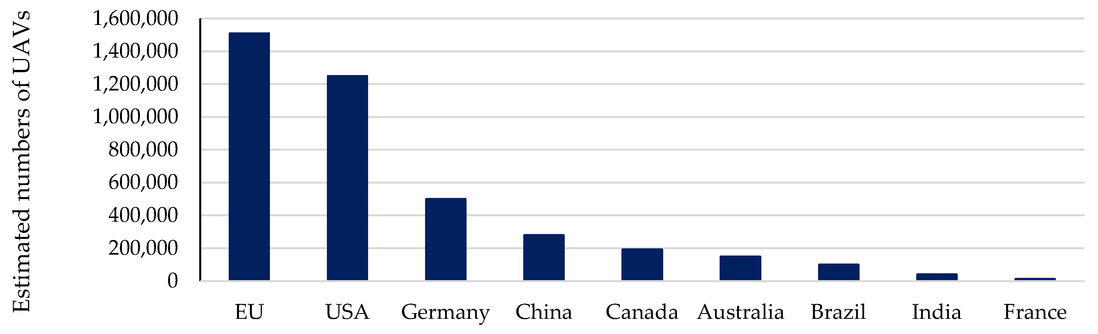
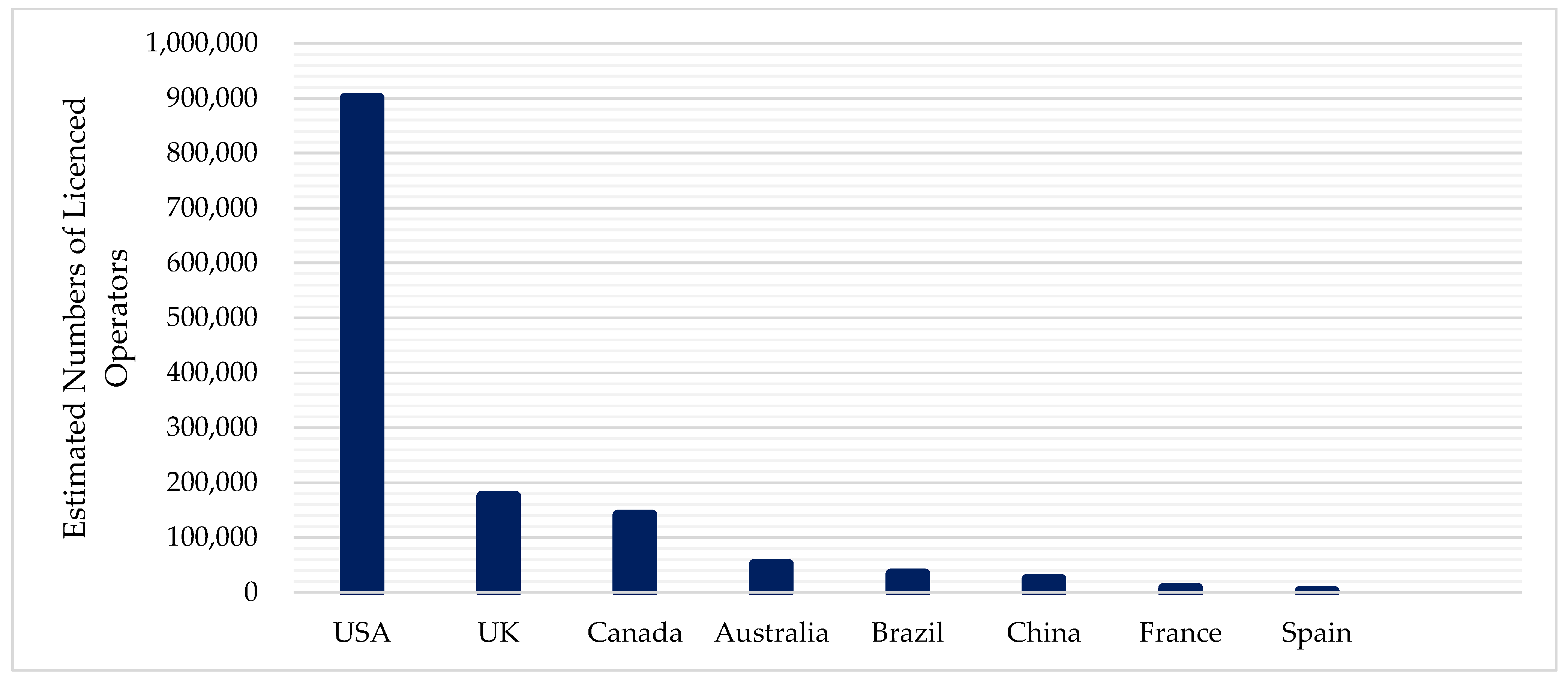
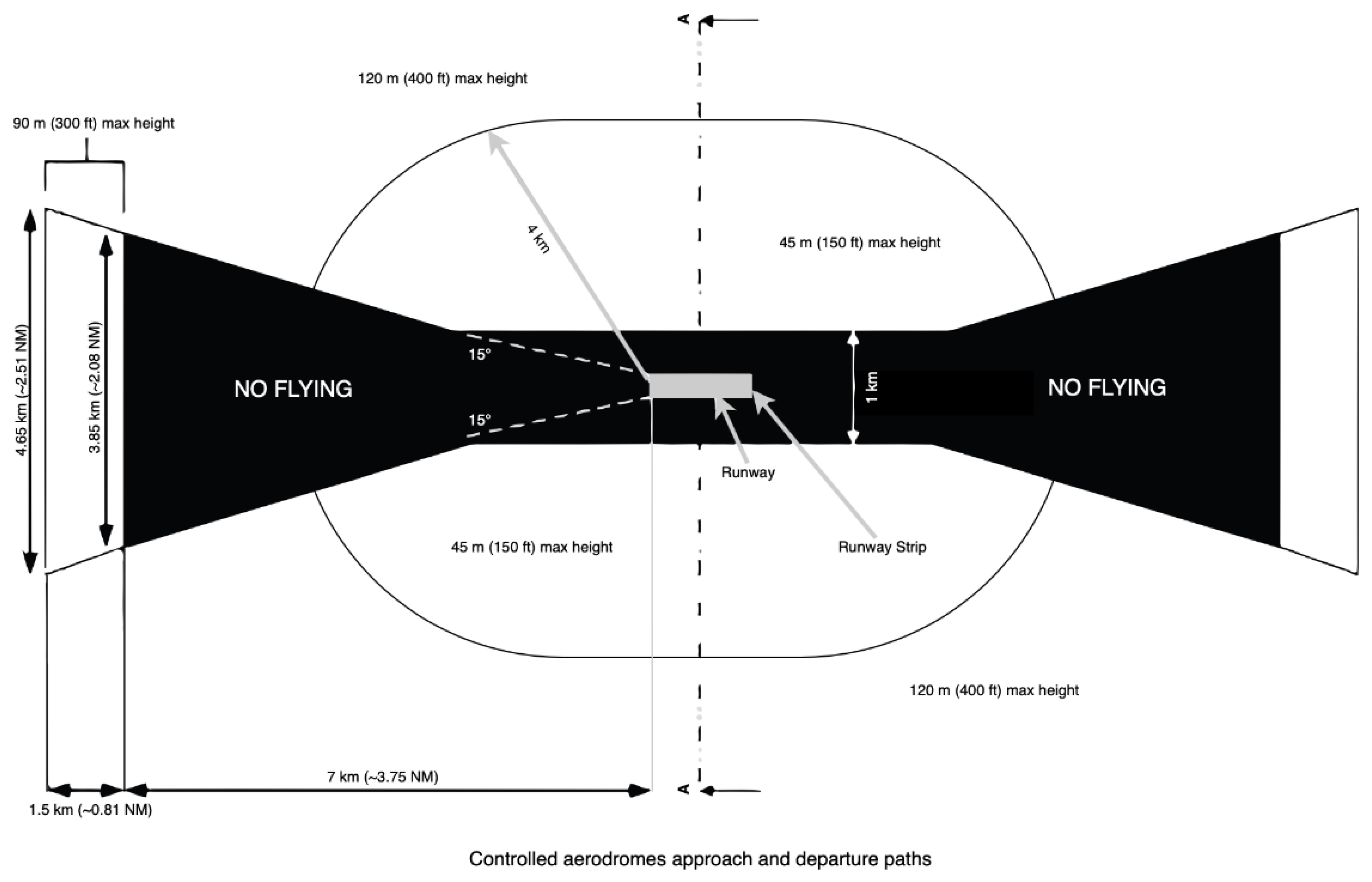
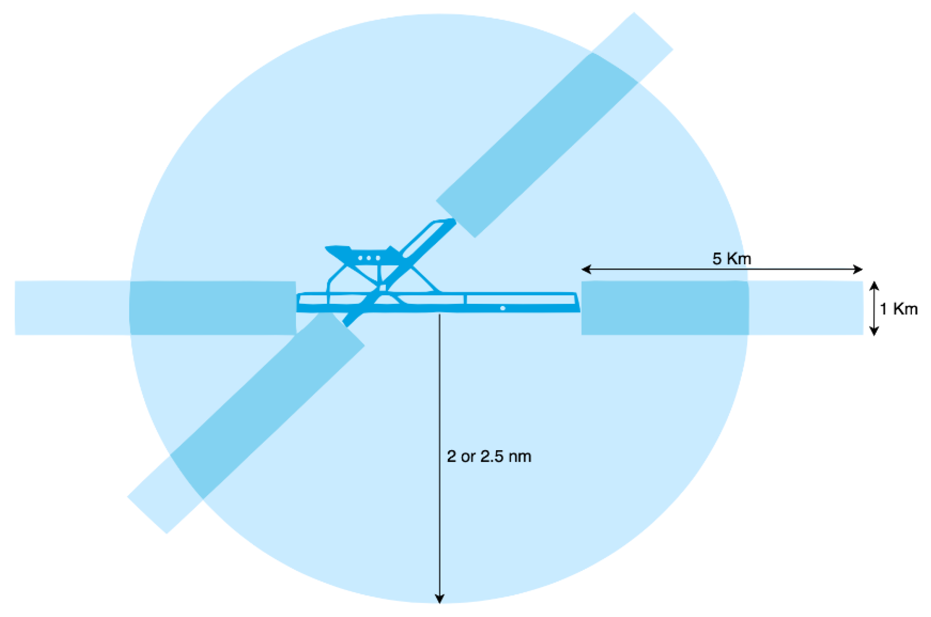
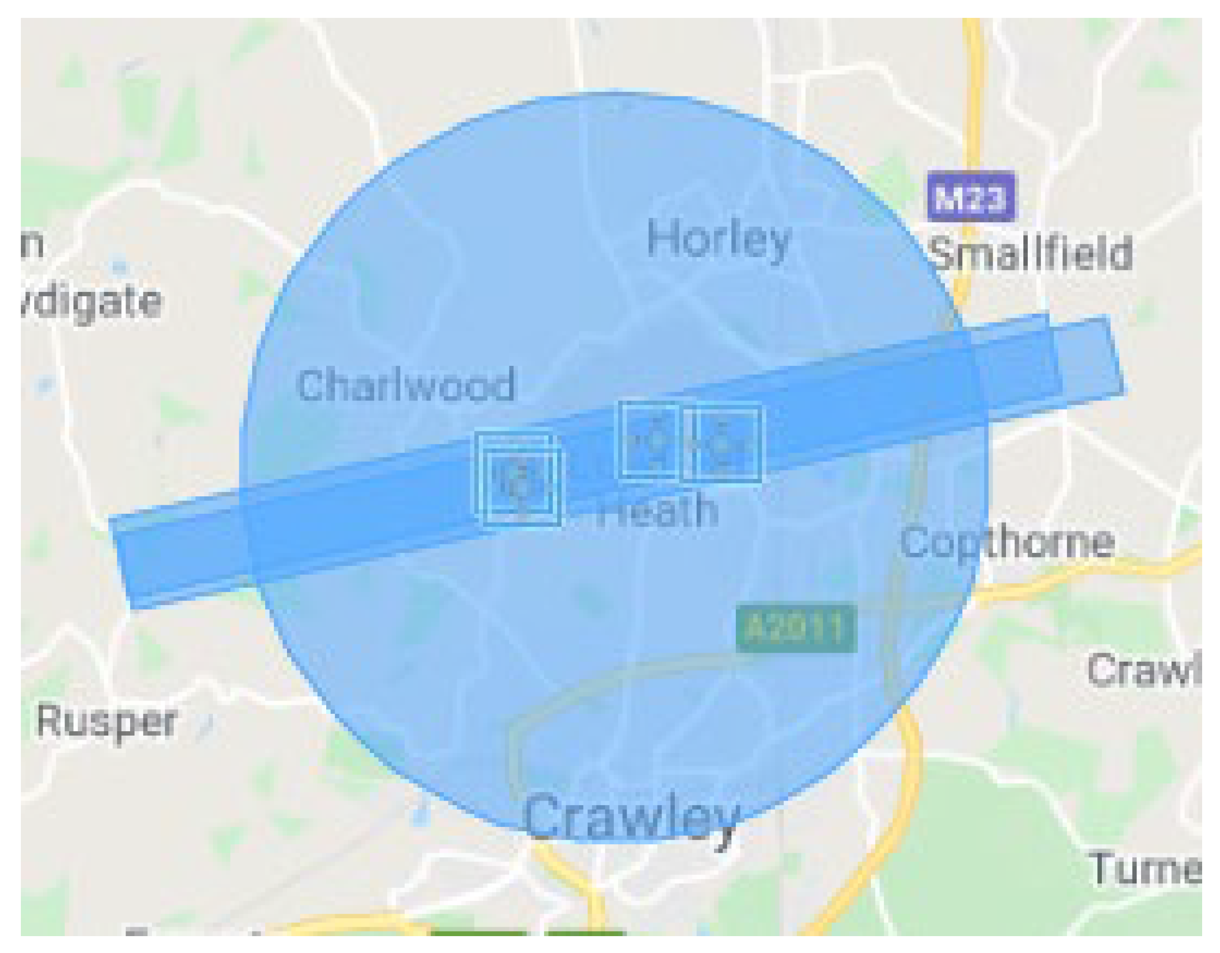
Table 1.
Countries Most Mentioned in the Literature.
| Choi-Fitzpatrick et al. [35] | Vela et al. [18] | GUAA [36] |
|---|---|---|
| USA | USA | USA |
| UK | Brazil | China |
| Australia | Australia | France |
| India | UK | Germany |
| Canada | Indonesia | Great Britain |
| China | Mexico | Australia |
| South Africa | Japan | |
| Chile | Canada | |
| Colombia | Switzerland | |
| Korea |
Table 2.
Sources of statistics in Figure 2.
Table 2.
Sources of statistics in Figure 2.
| USA | UK | Canada | Australia | Brazil | China | France | Spain |
|---|---|---|---|---|---|---|---|
| FAA [44] | CAA [9] | Canada Gazette [39] | CASA [1] | Unmanned Airspace [37] | Wangshu [40] | French Civil Aviation Authority [42] | Molina and Campos [4] |
Table 3.
General class for controlled or restricted airspace zone shape criteria of each jurisdiction (Author note: USA controlled airspace zones are predominantly radial and can be individually tailored polygons surrounding an airport).
Table 3.
General class for controlled or restricted airspace zone shape criteria of each jurisdiction (Author note: USA controlled airspace zones are predominantly radial and can be individually tailored polygons surrounding an airport).
| Australia | UK | USA | Canada | EU | |
|---|---|---|---|---|---|
| Radial | X | X | X | ✓ | X |
| Combination–Radial/Stadium curved shapes with Straight edge protected flight paths | ✓ | ✓ | X | X | X |
| Variable–radial and/or combination and/or polygonal shapes depending upon airport or jurisdiction | X | X | ✓ | X | ✓ |
✓: Criteria is considered; X: Criteria is not considered.
Publisher’s Note: MDPI stays neutral with regard to jurisdictional claims in published maps and institutional affiliations. |
© 2022 by the authors. Licensee MDPI, Basel, Switzerland. This article is an open access article distributed under the terms and conditions of the Creative Commons Attribution (CC BY) license (https://creativecommons.org/licenses/by/4.0/).
Share and Cite
MDPI and ACS Style
McTegg, S.J.; Tarsha Kurdi, F.; Simmons, S.; Gharineiat, Z. Comparative Approach of Unmanned Aerial Vehicle Restrictions in Controlled Airspaces. Remote Sens. 2022, 14, 822. https://0-doi-org.brum.beds.ac.uk/10.3390/rs14040822
AMA Style
McTegg SJ, Tarsha Kurdi F, Simmons S, Gharineiat Z. Comparative Approach of Unmanned Aerial Vehicle Restrictions in Controlled Airspaces. Remote Sensing. 2022; 14(4):822. https://0-doi-org.brum.beds.ac.uk/10.3390/rs14040822
Chicago/Turabian StyleMcTegg, Stephen John, Fayez Tarsha Kurdi, Shane Simmons, and Zahra Gharineiat. 2022. "Comparative Approach of Unmanned Aerial Vehicle Restrictions in Controlled Airspaces" Remote Sensing 14, no. 4: 822. https://0-doi-org.brum.beds.ac.uk/10.3390/rs14040822
Note that from the first issue of 2016, this journal uses article numbers instead of page numbers. See further details here.