1. Introduction
Grassland is one of the most important land use types. In Europe, it occupies more than a third of agricultural land, and as an ecosystem, it is characterised by its unique ecological value [
1]. Grassland differs in terms of management, yield, environmental and biodiversity value and intensification measures specific to different grassland types [
2]. It ranges from extensively managed semi-natural grassland with low intensity of use and high biodiversity value to intensively managed, monocultural and low biodiversity value grassland [
1,
2,
3]. The degree of intensification, i.e., manure and fertiliser inputs, grazing pressure, cutting frequency and grassland renewal, determines the productivity of grassland but can also be considered a proxy for its biodiversity value [
1]. In Europe, the area of low-intensity grassland has decreased significantly over the last 30 years, mainly due to increasing demand for food production [
3]. Extensively managed semi-natural grasslands are important habitats with high floristic diversity, and they provide shelter for numerous endangered plant and animal species (e.g., insectivorous birds) [
4]. Therefore, monitoring the management intensity of grassland is of great importance to optimise grassland use for different grassland values and management goals [
5]. There is also a need for detailed spatial data on grasslands (e.g., yield, species composition, habitat types, biodiversity value, annual cuttings status, fertilisation, grazing, etc.) in several European policy areas (e.g., Common Agricultural Policy, EU Climate policies, Biodiversity policies, Nitrates Directive, EU Habitats Directive and Renewable Energy Directive) [
1].
Earth observation sensors and their different properties have a high potential for large-scale biodiversity sensing [
6], grassland intensity use [
4,
7,
8], grassland management monitoring [
9,
10], and characterisation of different grassland types [
11]. The higher spatial, spectral and temporal resolution of available data has opened up the possibility of coming closer to the precise classification of individual plant species based on their spectral characteristics and ground-observed data [
6]. In Slovenia, the Institute of the Republic of Slovenia for Nature Conservation provides ground truth data for plant species composition by in situ field mapping of habitat. In situ data collection is expensive and time-consuming [
8], so its availability in a spatial and temporal context is limited.
A remote-sensing-based approach using multitemporal and high-resolution multisensor satellite data has been used to obtain new objective and cost-effective grassland information over large areas [
12,
13,
14,
15]. The Copernicus programme of the European Union and the European Space Agency and the launch of Synthetic Aperture Radar (SAR) Sentinel-1 and optical Sentinel-2 satellites with high temporal and spatial resolution provide a unique opportunity to study the monitoring of agricultural practices in grasslands with free and open data. Until now, satellite-based monitoring of grassland has been hampered by the availability of regular dense and gapless SITS with sufficient spatial and temporal resolution [
15,
16]. The optical twin satellites Sentinel-2A and -2B ensure land surface observations every five days [
17], and the radar satellites Sentinel-1A and -1B every six days for a single orbit direction (ascending or descending) or more frequently in the overlapping areas of adjacent orbits.
Optical satellite images are more commonly used in agricultural vegetation monitoring studies than radar data. Optical sensors can obtain information about the greening, vitality and density of grasslands [
18]. Unfortunately, multispectral optical imagery, such as Sentinel-2, depends on cloudless skies and sun illumination, resulting in fragmented SITS with significant missing data gaps [
15]. SAR data are complementary to optical sensors, as their measurements mainly relate to the physical structure of the vegetation [
19]. As the radar signal can penetrate clouds in all but extreme weather conditions and works without illumination [
12,
15,
16] it complements the optical signal well. The density of radar SITS is higher than that of optical SITS, especially in areas with frequent cloud cover. A dense temporal sampling throughout the season may describe the seasonal evolution of vegetation [
20]. The temporal change in variability of vegetation cover within grasslands detected in the dense SITS could be an effective indicator of specific processes related to intensification or abandonment.
Studies focusing on grassland management and use intensity mainly investigated relatively small study areas with homogeneous intensity levels among the grassland parcels [
18] and mostly one-year Sentinel time series (separately Sentinel-1 and Sentinel-2 scenes). Kolecka et al. [
21] evaluated the potential of the Sentinel-2 NDVI SITS (between 1 March 2017 and 1 November 2017) for mapping the intensity of permanent grassland with the recording of cutting frequency and dates of mowing events in the region of Canton Aargau, Switzerland (1403 km
2). Validation showed that the applied methodology correctly detected 96 out of 125 (77%) mowing events. They showed that detecting individual grass mowing events and grassland intensity mapping is possible with Sentinel-2 SITS using only carefully selected cloud-free images at crucial moments of the growing season. Mestre-Quereda et al. [
22] use the interferometric coherence of Sentinel-1 SITS (for the year 2017) to classify 17 different crop species in Spain. The results show that both radiometric and interferometric features and the shortest temporal baseline coherences (six days) provide good classification accuracy with all available intensity images. They also find that dual polarisation data always provide better classification results than single polarisation data, and that the joint use of coherence and backscatter coefficient increases the overall classification accuracy to over 86%. Holtgrave et al. [
15] compared Sentinel-1 SAR VV (vertical transmit, vertical receive) and VH (vertical transmit, horizontal receive) backscatter, VH/VV ratio, and radar vegetation index (RVI) with Sentinel-2 NDVI, Normalized Difference Water Index (NDWI), and Plant Senescence Radiation Index (PSRI) to distinguish four different European agricultural land use types (e.g., permanent grassland, maise, spring barley and winter wheat) in Lower Saxony, Germany for the year 2018. They found no general correlation between optical and SAR indices and found that the lowest correlation is in the case of grassland. Nevertheless, the joint use of both data types still offers great potential for agricultural monitoring, as more information can be collected on the ground than would be possible with only one data source.
The integration of multispectral and multitemporal remote sensing data with local knowledge and simulation models has successfully proven to be a valuable approach for identifying and monitoring a variety of agriculturally relevant features [
12]. Discriminating between grassland types is usually achieved using statistical, object-oriented or machine-learning classification approaches.
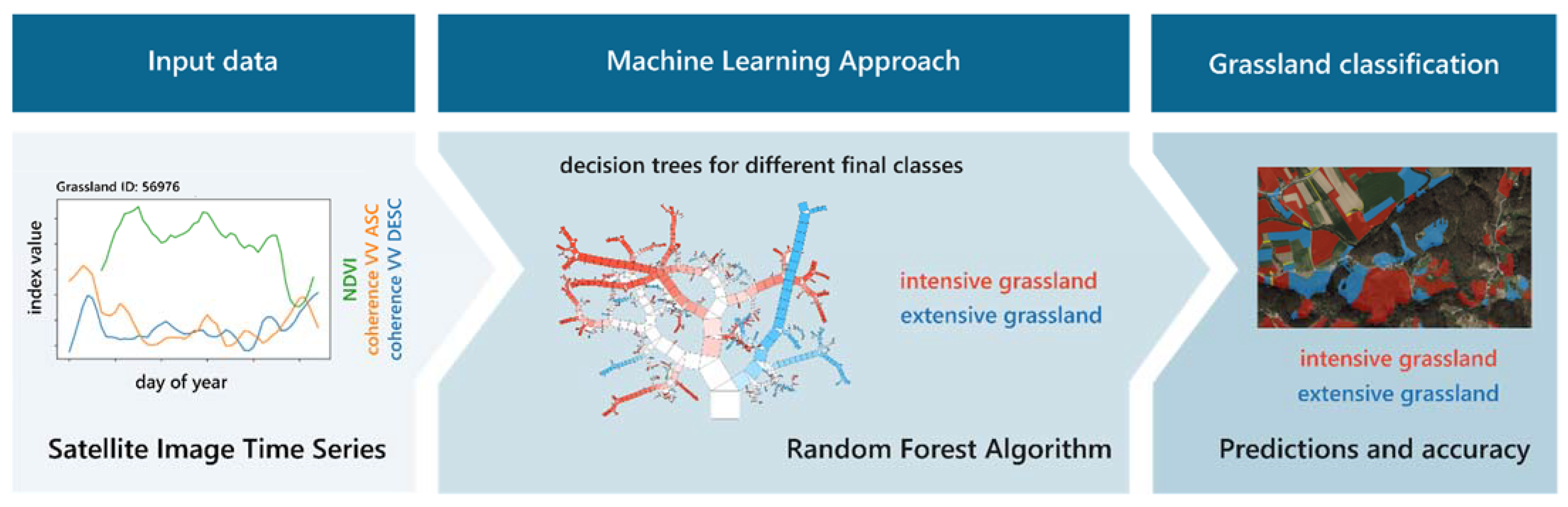
This study aims to assess the suitability of Random Forest algorithm and dense multisensor Sentinel SITS (NDVI and coherence) for classifying extensively and intensively managed permanent grassland in all of Slovenia (nearly 3060 km2).
The main objectives of our research were the following:
To analyse and evaluate the potential of intra-annual (from 2017 to 2019) Sentinel-1/2 SITS for distinguishing between intensively and extensively managed grassland at the parcel level.
To identify the importance of input features (acquisition dates, environmental variables, etc.) for grassland use intensity classification accuracy with Random Forest algorithm and combined multisensor SITS.
4. Discussion
This study has shown that multisensor time series of combined optical and radar remote-sensing data combined with environmental variables can effectively classify intensive and extensive grasslands in a large area of heterogeneous grassland stands. Several studies have highlighted the potential of Sentinel-1 and -2 data to characterise and classify different land use types, either separately or combined [
15,
51]. Still, only a few have used multisensor remote sensing imagery for grassland management and intensity use classification [
8,
18]. Most studies examined relatively small study areas with homogeneous intensity levels among grassland plots; however, larger heterogeneous landscapes with different environmental conditions and practices pose a challenge. Nevertheless, combined Sentinel-1 and -2 imagery to identify and characterise detailed grassland use remains underexplored. In this context, we seek to assess the potential of separate and combined Sentinel-1 and Sentinel-2 SITS for identifying and classifying the intensity of grassland use in a large study area covering the entire Slovenia. Our research analysed the RF algorithm in the combination of two different remote sensing products, optical NDVI and radar coherence, separately for the ascending and descending orbits, to identify the most appropriate features for grassland intensity use or management type separation.
Reinermann et al. [
18] noted that in most studies on remote sensing of grassland, optical satellite data were used as vegetation indices, with NDVI representing grassland conditions well. Several studies have investigated radar-based backscatter amplitudes, interferometric coherence, and polarimetry-based decomposition parameters, primarily for grassland mowing detection rather than general type classification [
50,
52,
53,
54]. In the present study, the combination of NDVI and coherence proved to be very useful and robust for grassland classification at a larger spatial scale.
In addition to the final grassland classification, our study improved understanding of the relationships between the separate and combined multisensory SITS of NDVI and coherence and the estimated biophysical parameters, such as individual grassland characteristics related to management or intensity use. Temporal analysis of satellite-based information allows us to gain insight into the dynamic phenological processes of a particular grassland type and specific events, such as mowing, etc. [
18,
21,
22,
55,
56].
Our study demonstrates the value of combining NDVI and coherence SITS for mapping and monitoring grassland use. Both SAR coherence and NDVI provided useful information for distinguishing between intensively and extensively managed grassland types. Temporal coherence profiles showed lower values for extensive grassland than for intensive grassland, while the opposite was observed for optical NDVI. Comparing optical Landsat and radar data ERS-2 SAR, Price et al. [
57] found that NDVI values were more important than radar backscatter data for classifying grassland types. Bekkema et al. [
8] concluded that for accurate grassland classification using only optical remote sensing data, the availability of satellite imagery in spring, preferably taken in April before the first mowing date, is essential. Our study showed similar results. NDVI values at the beginning of the growing season (in April and May) were the most important variables for separating intensive and extensive grassland. They can identify the main phase of highly dynamic vegetation growth [
8]. Radar coherence improves classification accuracy when the number of cloud-free optical images is insufficient in a given season. Coherence SITS are particularly useful in areas with high cloud cover, such as the Alps and pre-Alps areas.
However, there were no direct correlations between NDVI and coherence because NDVI indicates biophysical grassland variables, whereas coherence captures more vegetation physical variation and change. Nevertheless, coherence SITS behave inversely to NDVI SITS (
Figure 5). It reaches high values in the early and late seasons and low in the middle [
50], indicating the possibility and new opportunity to improve the time series classification approach to create denser fused radar-optical SITS. Research, including ours, suggests that radar coherence SITS is better suited for detecting specific events at the level of individual plots, such as mowing and grazing dates, and then incorporating these parameters into more advanced classification analysis. Therefore, NDVI and coherence time series are beneficial for grassland mowing detection [
10,
50,
58,
59] and can further improve grassland intensity mapping capabilities.
Many studies have used the RF algorithm for grassland management or intensity classification [
7,
18,
60]. Grabska et al. [
61] found that topographic variables can improve the accuracy of vegetation classification of RF in large heterogeneous areas because they have an indirect influence on plant growth [
15]. In our study, slope and elevation were also classified as features with a higher importance in all analysed years.
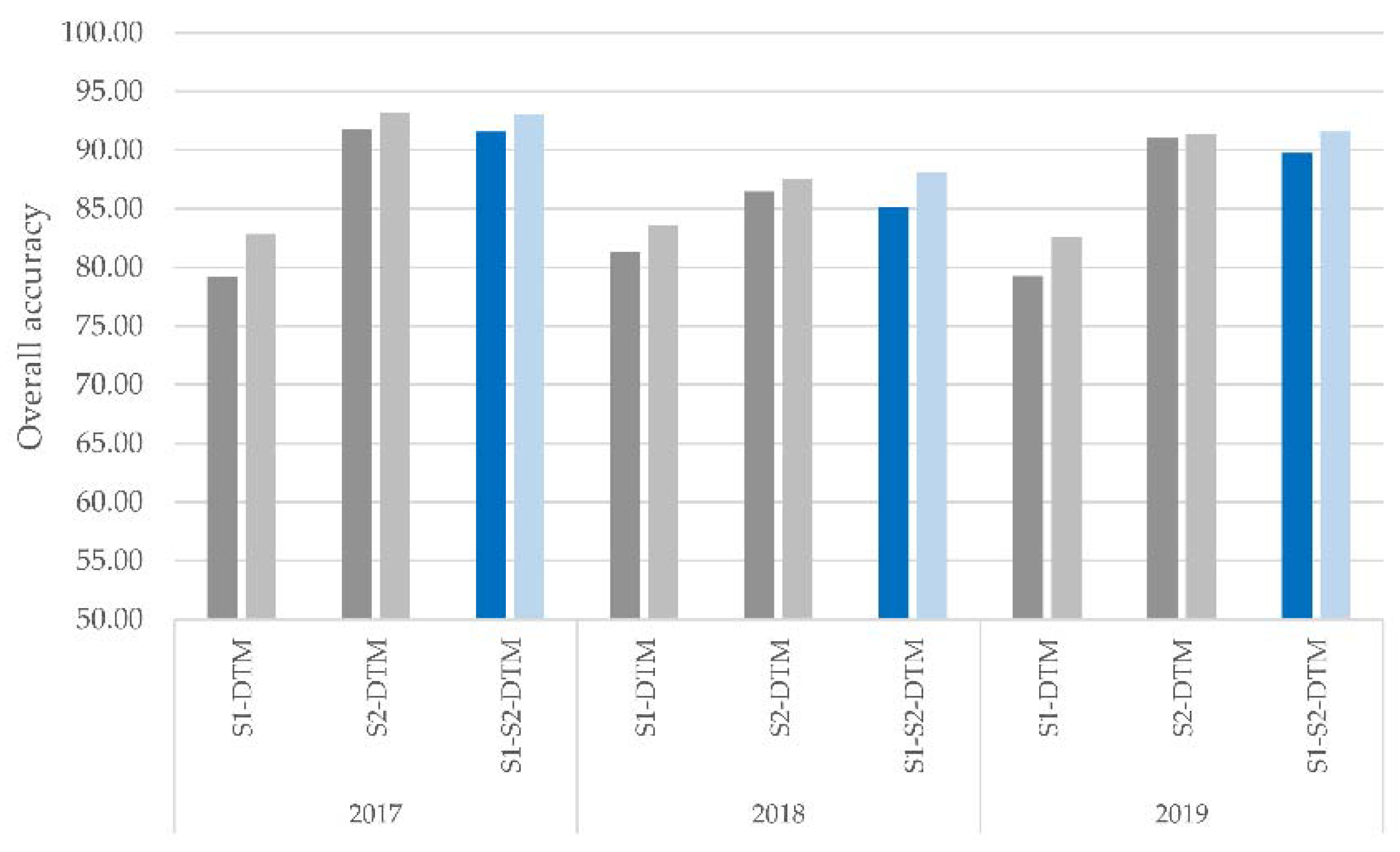
Using MDA, we reduced the dimensionality of the input SITS and found out which satellite image acquisition dates and attributes are more important/informative to build a model to discriminate between intensively and extensively managed grassland in a given year. In addition, the MDA criterion provided as an output of the RF classifier proved to be very efficient for feature selection. The overall accuracy (RF, object-based classification) obtained with the combination of all available annual features determined by MDA was only 2–3% lower than that obtained with the best feature selection combination (
Figure 7).
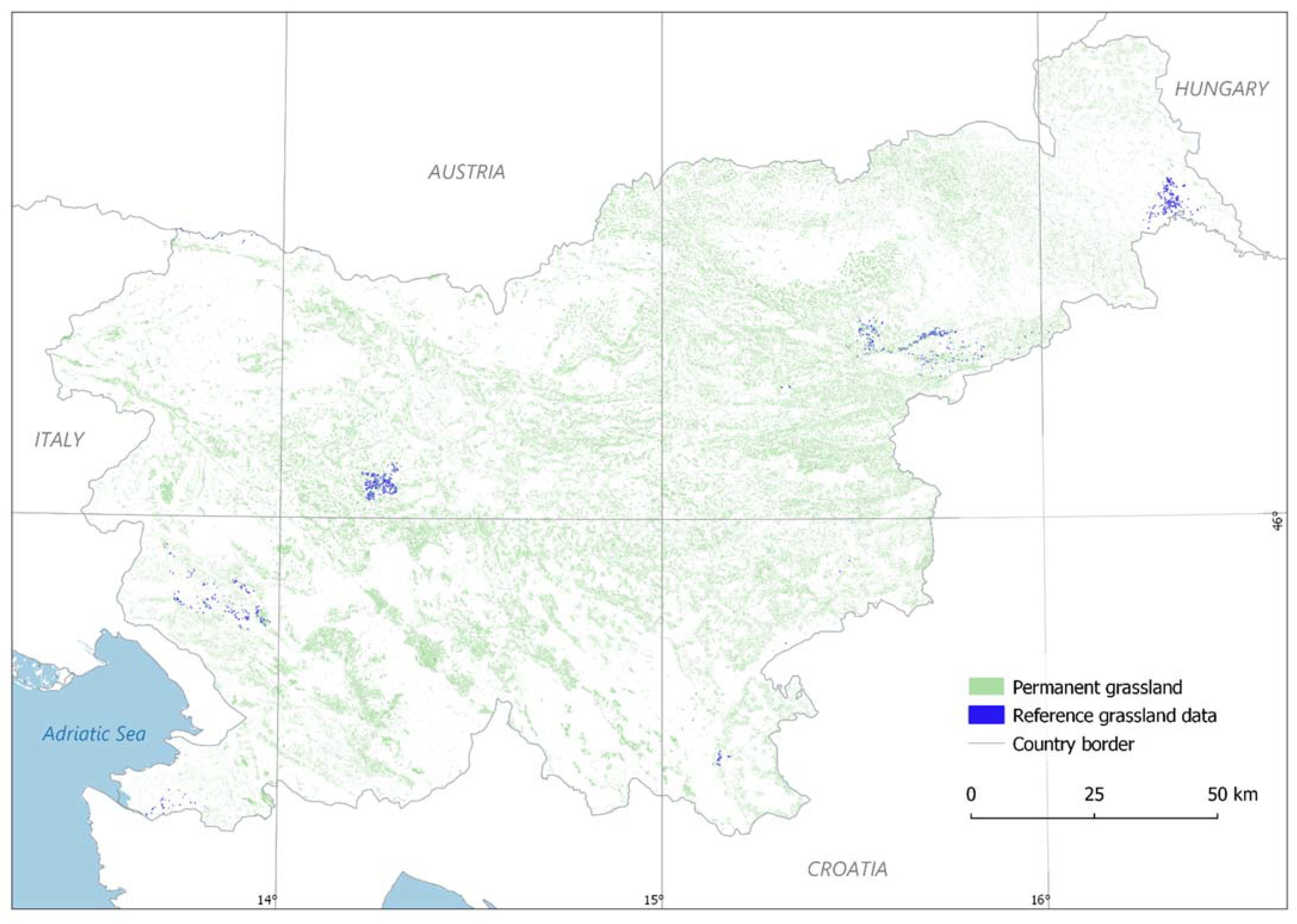
Classification accuracy was assessed using OA, PA, and the Kappa coefficient. Extensive grassland had a significantly lower producer and user accuracy than intensive grassland in all years studied, regardless of the combination of input data. For example, in 2017, user accuracy was 91% (RF, object-based, 2 classes, 20 selected features), while for intensive grassland it was 95%. In 2018, user accuracy for extensive grassland was only 81% (RF, object-based, 2 classes, 9 selected features), while for intensive grassland it was 93%. In 2019, the user’s accuracy for extensive grassland was again higher, at 87% (RF, object-based, 2 classes, 8 selected features), while for intensive grassland it was 94%. The low accuracies for extensive grassland were obtained due to its high biodiversity value (depending on soil texture), the large study area with environmental diversity, and the unbalanced training dataset (39% polygons for extensive grassland and 61% polygons for intensive grassland). Therefore, further research is needed to determine how to expand and balance the number of reference training samples to improve grassland classification with additional attributes obtained from Sentinel SITS, including areas where samples are not currently representative.


 ,
, 


