Special Issue Overview: Advances in Remote Sensing and Mapping for Integrated Studies of Reef Ecosystems in Oceania (Great Barrier Reef and Beyond)


Abstract
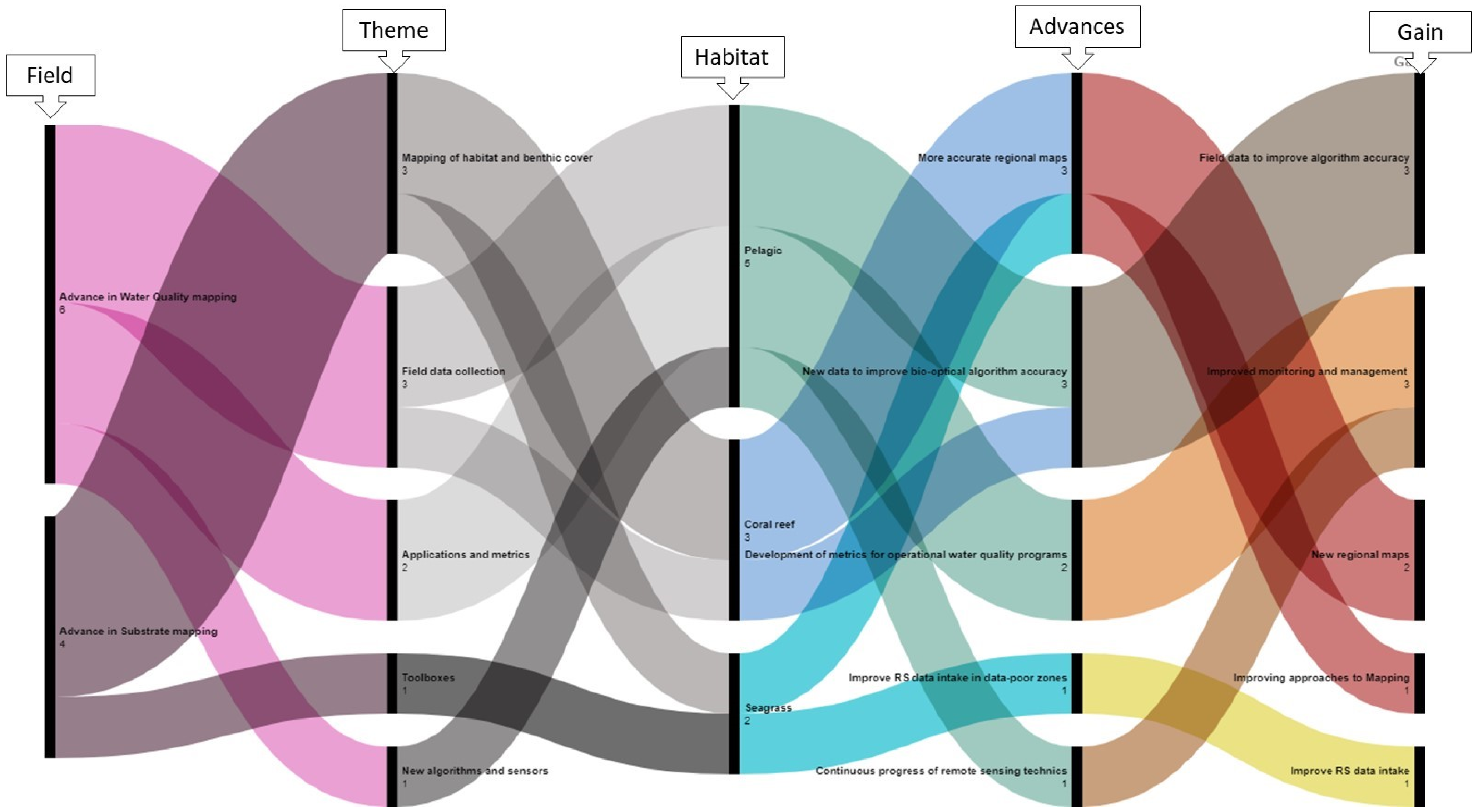
:1. Introduction

| Field | Theme | Habitats | Region | Title | Authors | Paper N0 with Citation |
|---|---|---|---|---|---|---|
| Adavance in Substrate mapping (coral reefs and seagrass). | Habitat and benthic cover mapping | Coral reef | Great Barrier Reef (East Australia) | How Much Shallow Coral Habitat Is There on the Great Barrier Reef? | Roelfsema CM, Lyons MB, Castro-Sanguino C, Kovacs EM, Callaghan D, Wettle M, Markey K, Borrego-Acevedo R, Tudman P, Roe M, Kennedy EV. | 1 |
| [58] | ||||||
| Ningaloo Reef (Western Australia) | Bathymetry Derivatives and Habitat Data from Hyperspectral Imagery Establish a High-Resolution Baseline for Managing the Ningaloo Reef, Western Australia | Halina T. Kobryn, Lynnath E. Beckley andKristin Wouters | 2 | |||
| [55] | ||||||
| Seagrass | Great Barrier Reef (East Australia) | Improving Approaches to Mapping Seagrass within the Great Barrier Reef: From Field to Spaceborne Earth Observation | Len J. McKenzie, Lucas A. Langlois and Chris M. Roelfsema | 3 | ||
| [59] | ||||||
| Toolboxes | Solomon Islands and Vanuatu (South Pacific) | A seagrass monitoring toolbox for South Pacific environments | Julie Bremner, Caroline Petus, Tony Dolphin, Jon Hawes, Benoît Beguet and Michelle Devlin | 4 | ||
| [39] | ||||||
| Advance in Water Quality mapping | In situ optical properties of the water column | Coral reef | Heron Island (South Great Barrier Reef) | Bio-Optical Measurements Indicative of Biogeochemical Transformations of Ocean Waters by Coral Reefs | Arnold G. Dekker, Lesley A. Clementson, Magnus Wettle, Nagur Cherukuru, Hannelie Botha and Kadija Oubelkheir | 5 |
| Coringa-Herald and Lihou Reefs | [54] | |||||
| (Coral Sea, East Australia) | ||||||
| Pelagic | Keppel Bay (inshore southern Great Barrier Reef) | Distinct Peaks of UV-Absorbing Compounds in CDOM and Particulate Absorption Spectra of Near-Surface Great Barrier Reef Coastal Waters, Associated with the Presence of Trichodesmium spp. (NE Australia) | Lesley A. Clementson, Kadija Oubelkheir, Phillip W. Ford and David Blondeau-Patissier | 6 | ||
| [51] | ||||||
| Pelagic | Princess Charlotte Bay (inshore northern GBR) | Impact of a tropical cyclone on terrestrial inputs and bio-optical properties in Princess Charlotte Bay (Great Barrier Reef lagoon) | Kadija Oubelkheir, Phillip W. Ford, Nagur Cherukuru, Lesley A. Clementson, | 7 | ||
| Caroline Petus, Michelle Devlin, Thomas Schroeder, Andrew D.L. Steven | [53] | |||||
| New algorithms and sensors | Pelagic | Great Barrier Reef (East Australia) | A Machine Learning Algorithm for Himawari-8 Total Suspended Solids Retrievals in the Great Barrier Reef | Larissa Patricio-Valerio, Thomas Schroeder, Michelle J. Devlin, Yi Qin and Scott Smithers | 8 | |
| [52] | ||||||
| Torres Strait (North-East Australia) | Using Optical Water-Type Classification in Data-Poor Water Quality Assessment: A Case Study in the Torres Strait | Caroline Petus, Jane Waterhouse, Dieter Tracey, Eric Wolanski and Jon Brodie | 9 | |||
| Applications and metrics | [56] | |||||
| Liverpool Bay (inshore United Kingdom). | Can Forel–Ule Index Act as a Proxy of Water Quality in Temperate Waters? Application of Plume Mapping in Liverpool Bay, UK | Lenka Fronkova, Naomi Greenwood, Roi Martinez, Jennifer A. Graham, Richard Harrod, Carolyn A. Graves, Michelle J. Devlin and Caroline Petus | 10 | |||
| [57] |
2. Overview of Manuscripts Published in Special Issue
2.1. Advances in Substrate Mapping (Coral Reefs and Seagrass)
2.2. Advances in Algorithms for Water Quality Measurements (from Coral Reefs and Surrounding Waters to Highly Turbid Coastal Waters)
3. Conclusions
Author Contributions
Funding
Data Availability Statement
Acknowledgments
Conflicts of Interest
References
- Woodhead, A.J.; Hicks, C.C.; Norström, A.V.; Williams, G.J.; Graham, N.A. Coral reef ecosystem services in the Anthropocene. Funct. Ecol. 2019, 33, 1023–1034. [Google Scholar] [CrossRef]
- Hughes, T.P.; Kerry, J.T.; Baird, A.H.; Connolly, S.R.; Dietzel, A.; Eakin, C.M.; Heron, S.F.; Hoey, A.S.; Hoogenboom, M.O.; Liu, G. Global warming transforms coral reef assemblages. Nature 2018, 556, 492–496. [Google Scholar] [CrossRef] [PubMed]
- Hughes, T.P.; Barnes, M.L.; Bellwood, D.R.; Cinner, J.E.; Cumming, G.S.; Jackson, J.B.; Kleypas, J.; Van De Leemput, I.A.; Lough, J.M.; Morrison, T.H. Coral reefs in the Anthropocene. Nature 2017, 546, 82–90. [Google Scholar] [CrossRef] [PubMed]
- Ferreira, M.A.; Froján, C.B.; Gunn, V.; Johnson, D.E. A role for UNEP’s Regional Seas Programme under the post-2020 global biodiversity framework. Mar. Policy 2022, 136, 104930. [Google Scholar] [CrossRef]
- Moberg, F.; Folke, C. Ecological goods and services of coral reef ecosystems. Ecol. Econ. 1999, 29, 215–233. [Google Scholar] [CrossRef]
- McKenzie, L.J.; Yoshida, R.L.; Aini, J.W.; Andréfouet, S.; Colin, P.L.; Cullen-Unsworth, L.C.; Hughes, A.T.; Payri, C.E.; Rota, M.; Shaw, C. Seagrass ecosystem contributions to people’s quality of life in the Pacific Island Countries and Territories. Mar. Pollut. Bull. 2021, 167, 112307. [Google Scholar] [CrossRef]
- Brodie, J.; Waterhouse, J. A critical review of environmental management of the ‘not so Great’ Barrier Reef. Estuar. Coast. Shelf Sci. 2012, 104–105, 1–22. [Google Scholar] [CrossRef]
- Brodie, J.E.; Devlin, M.; Haynes, D.; Waterhouse, J. Assessment of the eutrophication status of the Great Barrier Reef lagoon (Australia). Biogeochemistry 2010, 106, 281–302. [Google Scholar] [CrossRef]
- Devlin, M.J.; McKinna, L.W.; Alvarez-Romero, J.G.; Petus, C.; Abott, B.; Harkness, P.; Brodie, J. Mapping the pollutants in surface riverine flood plume waters in the Great Barrier Reef, Australia. Mar. Pollut. Bull. 2012, 65, 224–235. [Google Scholar] [CrossRef]
- Duran, A.; Shantz, A.; Burkepile, D.; Collado-Vides, L.; Ferrer, V.; Palma, L.; Ramos, A.; González-Díaz, P. Fishing, pollution, climate change, and the long-term decline of coral reefs off Havana, Cuba. Bull. Mar. Sci. 2018, 94, 213–228. [Google Scholar] [CrossRef]
- Dutra, L.X.; Haywood, M.D.; Singh, S.; Ferreira, M.; Johnson, J.E.; Veitayaki, J.; Kininmonth, S.; Morris, C.W.; Piovano, S. Synergies between local and climate-driven impacts on coral reefs in the Tropical Pacific: A review of issues and adaptation opportunities. Mar. Pollut. Bull. 2021, 164, 111922. [Google Scholar] [CrossRef] [PubMed]
- Johnson, J.E.; Allain, V.; Basel, B.; Bell, J.D.; Chin, A.; Dutra, L.X.; Hooper, E.; Loubser, D.; Lough, J.; Moore, B.R. Impacts of Climate Change on Marine Resources in the Pacific Island Region. In Climate Change and Impacts in the Pacific; Springer: Berlin/Heidelberg, Germany, 2020; pp. 359–402. [Google Scholar]
- Atkins, J.P.; Burdon, D.; Elliott, M.; Gregory, A.J. Management of the marine environment: Integrating ecosystem services and societal benefits with the DPSIR framework in a systems approach. Mar. Pollut. Bull. 2011, 62, 215–226. [Google Scholar] [CrossRef] [PubMed]
- Devlin, M.; Schaffelke, B. Catchment-to-reef continuum: Case studies from the Great Barrier Reef. A special issue--Marine Pollution Bulletin 2012. Mar. Pollut. Bull. 2012, 65, 77–80. [Google Scholar] [CrossRef] [PubMed]
- Devlin, M.J.; Lyons, B.P.; Johnson, J.E.; Hills, J.M. The tropical Pacific Oceanscape: Current issues, solutions and future possibilities. Mar. Pollut. Bull. 2021, 166, 112181. [Google Scholar] [CrossRef] [PubMed]
- Glibert, P.; Bouwman, L. Land-based Nutrient Pollution and the Relationship to Harmful Algal Blooms in Coastal Marine Systems. LOICZ Newsl. Inprint 2012, 2, 5–7. [Google Scholar]
- Kroon, F.J.; Schaffelke, B.; Bartley, R. Informing policy to protect coastal coral reefs: Insight from a global review of reducing agricultural pollution to coastal ecosystems. Mar. Pollut. Bull. 2014, 85, 33–41. [Google Scholar] [CrossRef]
- Lewis, S.E.; Brodie, J.E.; Bainbridge, Z.T.; Rohde, K.W.; Davis, A.M.; Masters, B.L.; Maughan, M.; Devlin, M.J.; Mueller, J.F.; Schaffelke, B. Herbicides: A new threat to the Great Barrier Reef. Environ. Pollut. 2009, 157, 2470–2484. [Google Scholar] [CrossRef]
- Packett, R.; Dougall, C.; Rohde, K.; Noble, R. Agricultural lands are hot-spots for annual runoff polluting the southern Great Barrier Reef lagoon. Mar. Pollut. Bull. 2009, 58, 976–986. [Google Scholar] [CrossRef]
- Smith, R.; Middlebrook, R.; Turner, R.; Huggins, R.; Vardy, S.; Warne, M. Large-scale pesticide monitoring across Great Barrier Reef catchments--Paddock to Reef Integrated Monitoring, Modelling and Reporting Program. Mar. Pollut. Bull. 2012, 65, 117–127. [Google Scholar] [CrossRef]
- Cinner, J.E.; Kittinger, J.N. 22 Linkages between social systems and coral reefs. In Ecology of Fishes on Coral Reefs; Cambridge University Press: Cambridge, UK, 2015; p. 215. [Google Scholar]
- Friedlander, A.M. Marine conservation in Oceania: Past, present, and future. Mar. Pollut. Bull. 2018, 135, 139–149. [Google Scholar] [CrossRef]
- Friedlander, A.M.; Gaymer, C.F. Progress, opportunities and challenges for marine conservation in the Pacific Islands. Aquat. Conserv. Mar. Freshw. Ecosyst. 2021, 31, 221–231. [Google Scholar] [CrossRef]
- McKenzie, L.J.; Yoshida, R.L.; Aini, J.W.; Andréfouet, S.; Colin, P.L.; Cullen-Unsworth, L.C.; Hughes, A.T.; Payri, C.E.; Rota, M.; Shaw, C. Seagrass ecosystems of the Pacific Island Countries and Territories: A global bright spot. Mar. Pollut. Bull. 2021, 167, 112308. [Google Scholar] [CrossRef]
- Smallhorn-West, P.F.; Weeks, R.; Gurney, G.; Pressey, R.L. Ecological and socioeconomic impacts of marine protected areas in the South Pacific: Assessing the evidence base. Biodivers. Conserv. 2020, 29, 349–380. [Google Scholar] [CrossRef]
- Craik, W. The Great Barrier Reef Marine Park: Its establishment, development and current status. Mar. Pollut. Bull. 1992, 25, 122–133. [Google Scholar] [CrossRef]
- Hughes, A.R.; Williams, S.L.; Duarte, C.M.; Heck, K.L., Jr.; Waycott, M. Associations of concern: Declining seagrasses and threatened dependent species. Front. Ecol. Environ. 2008, 7, 242–246. [Google Scholar] [CrossRef]
- Hughes, T.P.; Baird, A.H.; Bellwood, D.R.; Card, M.; Connolly, S.R.; Folke, C.; Grosberg, R.; Hoegh-Guldberg, O.; Jackson, J.B.; Kleypas, J. Climate change, human impacts, and the resilience of coral reefs. Science 2003, 301, 929–933. [Google Scholar] [CrossRef]
- Ray, C.; Matos, C.; Preisser, M.; Ellsworth, M. Vulnerability Mapping in Oceania. 2020. Available online: https://sites.utexas.edu/climatesecurity/files/2020/05/LBJ_Oceania_Mapping.pdf (accessed on 24 April 2023).
- De Souza, R.M.; Henly-Shepard, S.; McNamara, K.; Fernando, N. Re-Framing Island Nations as Champions of Resilience in the Face of Climate Change and Disaster Risk; United Nations University Institute of Environment and Human Security: Bonn, Germany, 2015. [Google Scholar]
- Mcleod, E.; Anthony, K.R.; Mumby, P.J.; Maynard, J.; Beeden, R.; Graham, N.A.; Heron, S.F.; Hoegh-Guldberg, O.; Jupiter, S.; MacGowan, P. The future of resilience-based management in coral reef ecosystems. J. Environ. Manag. 2019, 233, 291–301. [Google Scholar] [CrossRef]
- Stori, F.T.; Peres, C.M.; Turra, A.; Pressey, R.L. Traditional ecological knowledge supports ecosystem-based management in disturbed coastal marine social-ecological systems. Front. Mar. Sci. 2019, 6, 571. [Google Scholar] [CrossRef]
- Berkes, F.; Colding, J.; Folke, C. Rediscovery of traditional ecological knowledge as adaptive management. Ecol. Appl. 2000, 10, 1251–1262. [Google Scholar] [CrossRef]
- Anthony, K.R.; Marshall, P.A.; Abdulla, A.; Beeden, R.; Bergh, C.; Black, R.; Eakin, C.M.; Game, E.T.; Gooch, M.; Graham, N.A. Operationalizing resilience for adaptive coral reef management under global environmental change. Glob. Chang. Biol. 2015, 21, 48–61. [Google Scholar] [CrossRef]
- Weijerman, M.; Fulton, E.A.; Brainard, R.E. Management strategy evaluation applied to coral reef ecosystems in support of ecosystem-based management. PLoS ONE 2016, 11, e0152577. [Google Scholar] [CrossRef] [PubMed]
- Emslie, M.J.; Bray, P.; Cheal, A.J.; Johns, K.A.; Osborne, K.; Sinclair-Taylor, T.; Thompson, C.A. Decades of monitoring have informed the stewardship and ecological understanding of Australia’s Great Barrier Reef. Biol. Conserv. 2020, 252, 108854. [Google Scholar] [CrossRef]
- Schaffelke, B.; Carleton, J.; Skuza, M.; Zagorskis, I.; Furnas, M.J. Water quality in the inshore Great Barrier Reef lagoon: Implications for long-term monitoring and management. Mar. Pollut. Bull. 2012, 65, 249–260. [Google Scholar] [CrossRef] [PubMed]
- Obura, D.O.; Aeby, G.; Amornthammarong, N.; Appeltans, W.; Bax, N.; Bishop, J.; Brainard, R.E.; Chan, S.; Fletcher, P.; Gordon, T.A. Coral reef monitoring, reef assessment technologies, and ecosystem-based management. Front. Mar. Sci. 2019, 6, 580. [Google Scholar] [CrossRef]
- Bremner, J.; Petus, C.; Dolphin, T.; Hawes, J.; Beguet, B.; Devlin, M.J. A Seagrass Mapping Toolbox for South Pacific Environments. Remote Sens. 2023, 15, 834. [Google Scholar] [CrossRef]
- Petus, C.; Waterhouse, J.; Lewis, S.; Vacher, M.; Tracey, D.; Devlin, M. A flood of information: Using Sentinel-3 water colour products to assure continuity in the monitoring of water quality trends in the Great Barrier Reef (Australia). J. Environ. Manag. 2019, 248, 109255. [Google Scholar] [CrossRef]
- Petus, C.; Devlin, M.; Thompson, A.; McKenzie, L.; Teixeira da Silva, E.; Collier, C.; Tracey, D.; Martin, K. Estimating the exposure of coral reefs and seagrass meadows to land-sourced contaminants in river flood plumes of the Great Barrier Reef: Validating a simple satellite risk framework with environmental data. Remote Sens. 2016, 8, 210. [Google Scholar] [CrossRef]
- Devlin, M.J.; Álvarez-Romero, J.; da Silva, E.T.; DeBose, J.; Petus, C.; Wenger, A. Reef Rescue Marine Monitoring Program. Final Report of JCU Activities 2011/12—Flood Plumes and Extreme Weather Monitoring for the Great Barrier Reef Marine Park Authority; James Cook University: Townsville, Australia, 2013. [Google Scholar]
- Waterhouse, J.; Gruber, R.; Logan, M.; Petus, C.; Howley, C.; Lewis, S.; Tracey, D.; James, C.; Mellors, J.; Tonin, H. Marine Monitoring Program: Annual Report for Inshore Water Quality Monitoring 2019-20; Great Barrier Reef Marine Park Authority: Townsville, Australia, 2021. [Google Scholar]
- Lyons, M.B.; Roelfsema, C.M.; Kennedy, E.V.; Kovacs, E.M.; Borrego-Acevedo, R.; Markey, K.; Roe, M.; Yuwono, D.M.; Harris, D.L.; Phinn, S.R. Mapping the world’s coral reefs using a global multiscale earth observation framework. Remote Sens. Ecol. Conserv. 2020, 6, 557–568. [Google Scholar] [CrossRef]
- Gall, M.P.; Pinkerton, M.H.; Steinmetz, T.; Wood, S. Satellite remote sensing of coastal water quality in New Zealand. N. Z. J. Mar. Freshw. Res. 2022, 56, 585–616. [Google Scholar] [CrossRef]
- Naidu, R.; Muller-Karger, F.; McCarthy, M. Mapping of benthic habitats in Komave, Coral coast using worldview-2 satellite imagery. In Climate Change Impacts and Adaptation Strategies for Coastal Communities; Springer: Berlin/Heidelberg, Germany, 2018; pp. 337–355. [Google Scholar]
- Xu, Y.; Vaughn, N.R.; Knapp, D.E.; Martin, R.E.; Balzotti, C.; Li, J.; Foo, S.A.; Asner, G.P. Coral bleaching detection in the hawaiian islands using spatio-temporal standardized bottom reflectance and planet dove satellites. Remote Sens. 2020, 12, 3219. [Google Scholar] [CrossRef]
- Williamson, M.J.; Tebbs, E.J.; Dawson, T.P.; Thompson, H.J.; Head, C.E.; Jacoby, D.M. Monitoring shallow coral reef exposure to environmental stressors using satellite earth observation: The reef environmental stress exposure toolbox (RESET). Remote Sens. Ecol. Conserv. 2022, 8, 855–874. [Google Scholar] [CrossRef]
- Spalding, M.; Spalding, M.D.; Ravilious, C.; Green, E.P. World Atlas of Coral Reefs; University of California Press: Berkele, CA, USA, 2001. [Google Scholar]
- Cowburn, B.; Alliji, K.; Bluemel, J.K.; Couce, E.; Lawrance, E.; McManus, E.; van Hoytema, N.; Devlin, M. Ecosystem-based management of coral reefs from afar–A guide for remote scientists and remote places. Environ. Sci. Policy 2023, 139, 29–38. [Google Scholar] [CrossRef]
- Clementson, L.A.; Oubelkheir, K.; Ford, P.W.; Blondeau-Patissier, D. Distinct Peaks of UV-Absorbing Compounds in CDOM and Particulate Absorption Spectra of Near-Surface Great Barrier Reef Coastal Waters, Associated with the Presence of Trichodesmium spp.(NE Australia). Remote Sens. 2022, 14, 3686. [Google Scholar] [CrossRef]
- Patricio-Valerio, L.; Schroeder, T.; Devlin, M.J.; Qin, Y.; Smithers, S. A Machine Learning Algorithm for Himawari-8 Total Suspended Solids Retrievals in the Great Barrier Reef. Remote Sens. 2022, 14, 3503. [Google Scholar] [CrossRef]
- Oubelkheir, K.; Ford, P.W.; Cherukuru, N.; Clementson, L.A.; Petus, C.; Devlin, M.; Schroeder, T.; Steven, A.D. Impact of a Tropical Cyclone on Terrestrial Inputs and Bio-Optical Properties in Princess Charlotte Bay (Great Barrier Reef Lagoon). Remote Sens. 2023, 15, 652. [Google Scholar] [CrossRef]
- Dekker, A.G.; Clementson, L.A.; Wettle, M.; Cherukuru, N.; Botha, H.; Oubelkheir, K. Bio-Optical Measurements Indicative of Biogeochemical Transformations of Ocean Waters by Coral Reefs. Remote Sens. 2022, 14, 2892. [Google Scholar] [CrossRef]
- Kobryn, H.T.; Beckley, L.E.; Wouters, K. Bathymetry Derivatives and Habitat Data from Hyperspectral Imagery Establish a High-Resolution Baseline for Managing the Ningaloo Reef, Western Australia. Remote Sens. 2022, 14, 1827. [Google Scholar] [CrossRef]
- Petus, C.; Waterhouse, J.; Tracey, D.; Wolanski, E.; Brodie, J. Using Optical Water-Type Classification in Data-Poor Water Quality Assessment: A Case Study in the Torres Strait. Remote Sens. 2022, 14, 2212. [Google Scholar] [CrossRef]
- Fronkova, L.; Greenwood, N.; Martinez, R.; Graham, J.A.; Harrod, R.; Graves, C.A.; Devlin, M.J.; Petus, C. Can Forel–Ule Index Act as a Proxy of Water Quality in Temperate Waters? Application of Plume Mapping in Liverpool Bay, UK. Remote Sens. 2022, 14, 2375. [Google Scholar] [CrossRef]
- Roelfsema, C.M.; Lyons, M.B.; Castro-Sanguino, C.; Kovacs, E.M.; Callaghan, D.; Wettle, M.; Markey, K.; Borrego-Acevedo, R.; Tudman, P.; Roe, M. How Much Shallow Coral Habitat Is There on the Great Barrier Reef? Remote Sens. 2021, 13, 4343. [Google Scholar] [CrossRef]
- McKenzie, L.J.; Langlois, L.A.; Roelfsema, C.M. Improving Approaches to Mapping Seagrass within the Great Barrier Reef: From Field to Spaceborne Earth Observation. Remote Sens. 2022, 14, 2604. [Google Scholar] [CrossRef]
- Roelfsema, C.M.; Kovacs, E.M.; Ortiz, J.C.; Callaghan, D.P.; Hock, K.; Mongin, M.; Johansen, K.; Mumby, P.J.; Wettle, M.; Ronan, M. Habitat maps to enhance monitoring and management of the Great Barrier Reef. Coral Reefs 2020, 39, 1039–1054. [Google Scholar] [CrossRef]
- Wolff, N.H.; Mumby, P.J.; Devlin, M.; Anthony, K.R. Vulnerability of the Great Barrier Reef to climate change and local pressures. Glob. Chang. Biol. 2018, 24, 1978–1991. [Google Scholar] [CrossRef] [PubMed]
- Mumby, P.; Green, E.; Edwards, A.; Clark, C. Coral reef habitat mapping: How much detail can remote sensing provide? Mar. Biol. 1997, 130, 193–202. [Google Scholar] [CrossRef]
- Kennedy, E.V.; Roelfsema, C.M.; Lyons, M.B.; Kovacs, E.M.; Borrego-Acevedo, R.; Roe, M.; Phinn, S.R.; Larsen, K.; Murray, N.J.; Yuwono, D. Reef Cover, a coral reef classification for global habitat mapping from remote sensing. Sci. Data 2021, 8, 196. [Google Scholar] [CrossRef]
- Petus, C.; Collier, C.; Devlin, M.; Rasheed, M.; McKenna, S. Using MODIS data for understanding changes in seagrass meadow health: A case study in the Great Barrier Reef (Australia). Mar. Environ. Res. 2014, 98, 68–85. [Google Scholar] [CrossRef]
- Devlin, M.J.; da Silva, E.; Petus, C.; Wenger, A.; Zeh, D.; Tracey, D.; Álvarez-Romero, J.G.; Brodie, J. Combining in-situ water quality and remotely sensed data across spatial and temporal scales to measure variability in wet season chlorophyll-a: Great Barrier Reef lagoon (Queensland, Australia). Ecol. Process. 2013, 2, 31. [Google Scholar] [CrossRef]
- Petus, C.; Devlin, M.; da Silva, E.T.; Lewis, S.; Waterhouse, J.; Wenger, A.; Bainbridge, Z.; Tracey, D. Defining wet season water quality target concentrations for ecosystem conservation using empirical light attenuation models: A case study in the Great Barrier Reef (Australia). J. Environ. Manag. 2018, 213, 451–466. [Google Scholar] [CrossRef]
- Devlin, M.; Petus, C.; da Silva, E.; Alvarez-Romero, J.G.; Zeh, D.; Waterhouse, J.; Brodie, J. Chapter 5: Mapping of Exposure to Flood Plumes, Water Types and Exposure to Pollutants (DIN, TSS) in the Great Barrier Reef: Toward the Production of Operational Risk Maps for the World’s Most Iconic Marine Ecosystem; TropWATER: Townsville, Australia, 2013. [Google Scholar]
- Schroeder, T.; Devlin, M.J.; Brando, V.E.; Dekker, A.G.; Brodie, J.E.; Clementson, L.A.; McKinna, L. Inter-annual variability of wet season freshwater plume extent into the Great Barrier Reef lagoon based on satellite coastal ocean colour observations. Mar. Pollut. Bull. 2012, 65, 210–223. [Google Scholar] [CrossRef]
- Greenwood, N.; Devlin, M.J.; Best, M.; Fronkova, L.; Graves, C.A.; Milligan, A.; Barry, J.; Van Leeuwen, S.M. Utilizing eutrophication assessment directives from transitional to marine systems in the Thames Estuary and Liverpool Bay, UK. Front. Mar. Sci. 2019, 6, 116. [Google Scholar] [CrossRef]
- Greenwood, N.; Forster, R.M.; Créach, V.; Painting, S.J.; Dennis, A.; Cutchey, S.J.; Silva, T.; Sivyer, D.B.; Jickells, T. Seasonal and interannual variation of the phytoplankton and copepod dynamics in Liverpool Bay. Ocean Dyn. 2012, 62, 307–320. [Google Scholar] [CrossRef]
- Gowen, R.J.; Tett, P.; Kennington, K.; Mills, D.K.; Shammon, T.M.; Stewart, B.M.; Greenwood, N.; Flanagan, C.; Devlin, M.; Wither, A. The Irish Sea: Is it eutrophic? Estuar. Coast. Shelf Sci. 2008, 76, 239–254. [Google Scholar] [CrossRef]
- Garaba, S.P.; Friedrichs, A.; Voß, D.; Zielinski, O. Classifying natural waters with the Forel-Ule Colour index system: Results, applications, correlations and crowdsourcing. Int. J. Environ. Res. Public Health 2015, 12, 16096–16109. [Google Scholar] [CrossRef]
- Ceccaroni, L.; Piera, J.; Wernand, M.R.; Zielinski, O.; Busch, J.A.; Van Der Woerd, H.J.; Bardaji, R.; Friedrichs, A.; Novoa, S.; Thijsse, P. Citclops: A next-generation sensor system for the monitoring of natural waters and a citizens’ observatory for the assessment of ecosystems’ status. PLoS ONE 2020, 15, e0230084. [Google Scholar] [CrossRef] [PubMed]

| Challenges that Hinder the Use of RS Technologies in Oceania | Definition |
|---|---|
| Communication | Disconnection between academic research on remote sensing theories and the actual application by other scientist and managers of reef ecosystems |
| Knowledge | General lack of knowledge on the availability, suitability, cost and resolution of the various remote sensing datasets currently available |
| Methodological | Including the lack of standard methodologies for mapping water quality and habitats in coral reefs regions, or limited expertise and technical skills in monitoring teams to apply or adjust existing methodologies or applications |
| Confidence | Issues around accuracy, specifically data retrievals in nearshore and coastal areas where shallow, highly complex waters can reduce the accuracy of the remote sensed data or a general mistrust in the scientific value of the remote sensing techniques |
| Local | Including site safety and accessibility as well as financial or logistical constraints. Limit accessibility to ground reference data |
Disclaimer/Publisher’s Note: The statements, opinions and data contained in all publications are solely those of the individual author(s) and contributor(s) and not of MDPI and/or the editor(s). MDPI and/or the editor(s) disclaim responsibility for any injury to people or property resulting from any ideas, methods, instructions or products referred to in the content. |
© 2023 by the authors. Licensee MDPI, Basel, Switzerland. This article is an open access article distributed under the terms and conditions of the Creative Commons Attribution (CC BY) license (https://creativecommons.org/licenses/by/4.0/).
Share and Cite
Devlin, M.J.; Petus, C.; Oubelkheir, K. Special Issue Overview: Advances in Remote Sensing and Mapping for Integrated Studies of Reef Ecosystems in Oceania (Great Barrier Reef and Beyond). Remote Sens. 2023, 15, 2505. https://0-doi-org.brum.beds.ac.uk/10.3390/rs15102505
Devlin MJ, Petus C, Oubelkheir K. Special Issue Overview: Advances in Remote Sensing and Mapping for Integrated Studies of Reef Ecosystems in Oceania (Great Barrier Reef and Beyond). Remote Sensing. 2023; 15(10):2505. https://0-doi-org.brum.beds.ac.uk/10.3390/rs15102505
Chicago/Turabian StyleDevlin, Michelle J., Caroline Petus, and Kadija Oubelkheir. 2023. "Special Issue Overview: Advances in Remote Sensing and Mapping for Integrated Studies of Reef Ecosystems in Oceania (Great Barrier Reef and Beyond)" Remote Sensing 15, no. 10: 2505. https://0-doi-org.brum.beds.ac.uk/10.3390/rs15102505