Article

The Sustainable Development of Street Texture of Historic and Cultural Districts―A Case Study in Shichahai District, Beijing

1
College of Applied Arts & Science, Beijing Union University, Beijing100191, China
2
Urban Studies, Rhodes College, Memphis, TN 38112, USA
*
Author to whom correspondence should be addressed.
Sustainability 2018, 10(7), 2343; https://0-doi-org.brum.beds.ac.uk/10.3390/su10072343
Submission received: 31 May 2018 / Revised: 2 July 2018 / Accepted: 2 July 2018 / Published: 6 July 2018
(This article belongs to the Special Issue Local Heritage and Sustainability)

Abstract

:
This paper explores the sustainable development of historic and cultural districts based on the case study of the Shichahai District in Beijing, China. By using the space syntax method, this paper traces the changing street texture of the Shichahai District during the Yuan period, the Ming period, the Qing period, and the current period. It attempts to examine (1) the characteristics of the traditional street structure of Old Beijing; (2) the major changes of street fabric and their causes during the historical periods; and (3) the impacts of modern land use pattern on urban street structure. This research finds that the main street texture remains relatively stable in the Shichahai District. However, the increasing dependence on cars in Beijing decreases street vitality in general. But the combination of pedestrian and community-level commercial streets helps enhancing the liveliness of historic and cultural districts, which further promotes the preservation and development of these neighborhoods.

1. Introduction

The urban textures of historic and cultural districts vary due to different local development processes and policies. These districts have their unique spatial order and organization, reflecting the characteristics of local historic context and heritage. With the acceleration of urbanization and modernization in China, the historic districts are faced with changes of both internal and external environment. For example, the increasing dependence on cars and need for transportation efficiency in China forces the streets in these historic areas to adapt to the driving scale. As a result, the traditional street texture was damaged, and the cultural and historic continuity and heritage were interrupted. It also decreased the street vitality. By using the Shichahai District as an example, this research applies the space syntax method to trace the changes of street texture in historic districts and explore their causes. Additionally, this paper attempts to discuss the strategies of sustainable development of historic districts in the era of urban modernization in China.
This paper begins with the literature review of the studies of urban structure of historic districts. Then it introduces the study area, followed by the section that presents the method and data collection for this research. The next section analyzes the characteristics of major changes of street texture in the Shichahai District during the four periods, and examines the relationships among urban texture, transportation, and land use pattern. Finally, the paper concludes with discussions of the major results.

2. Literature Review
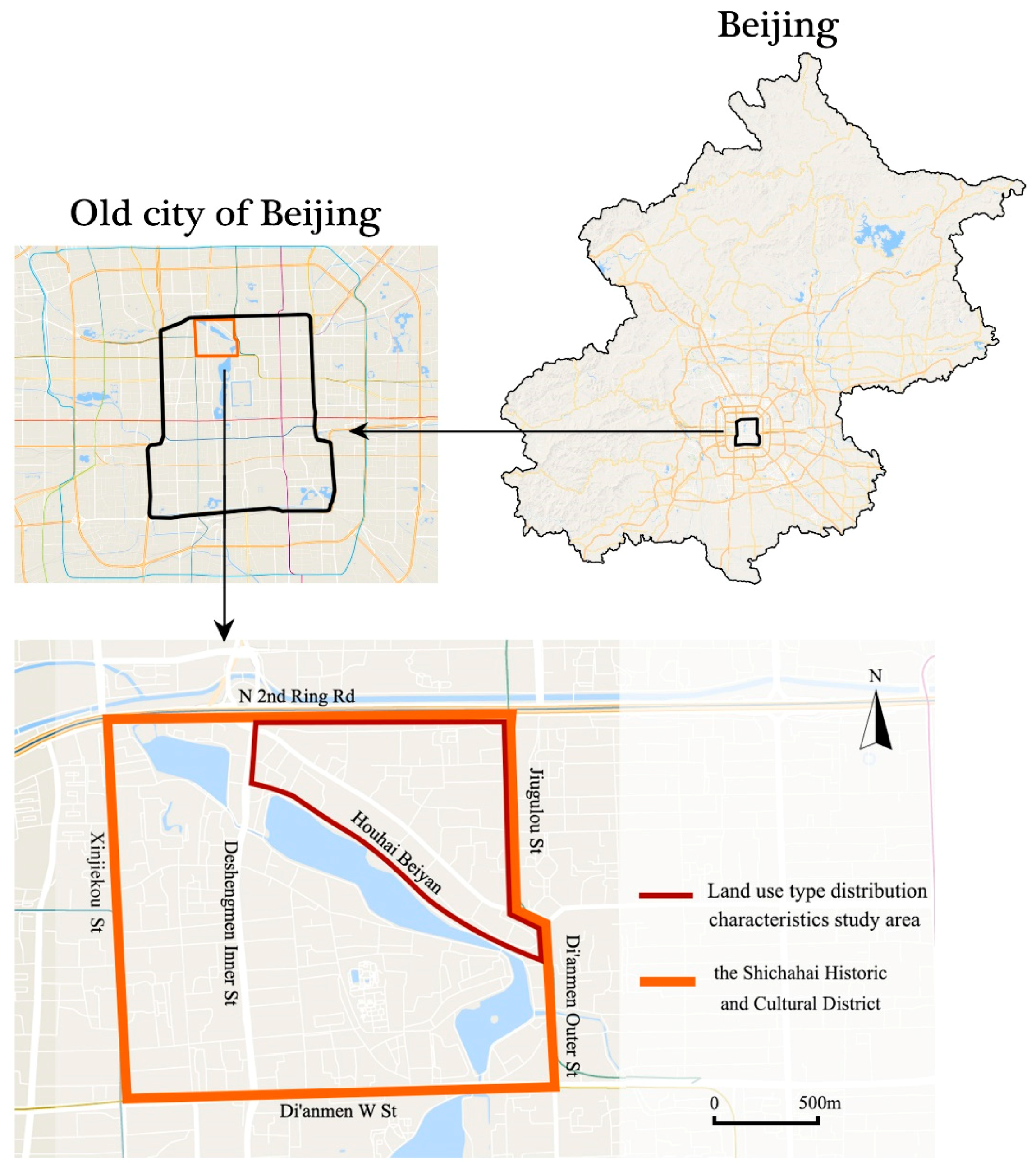
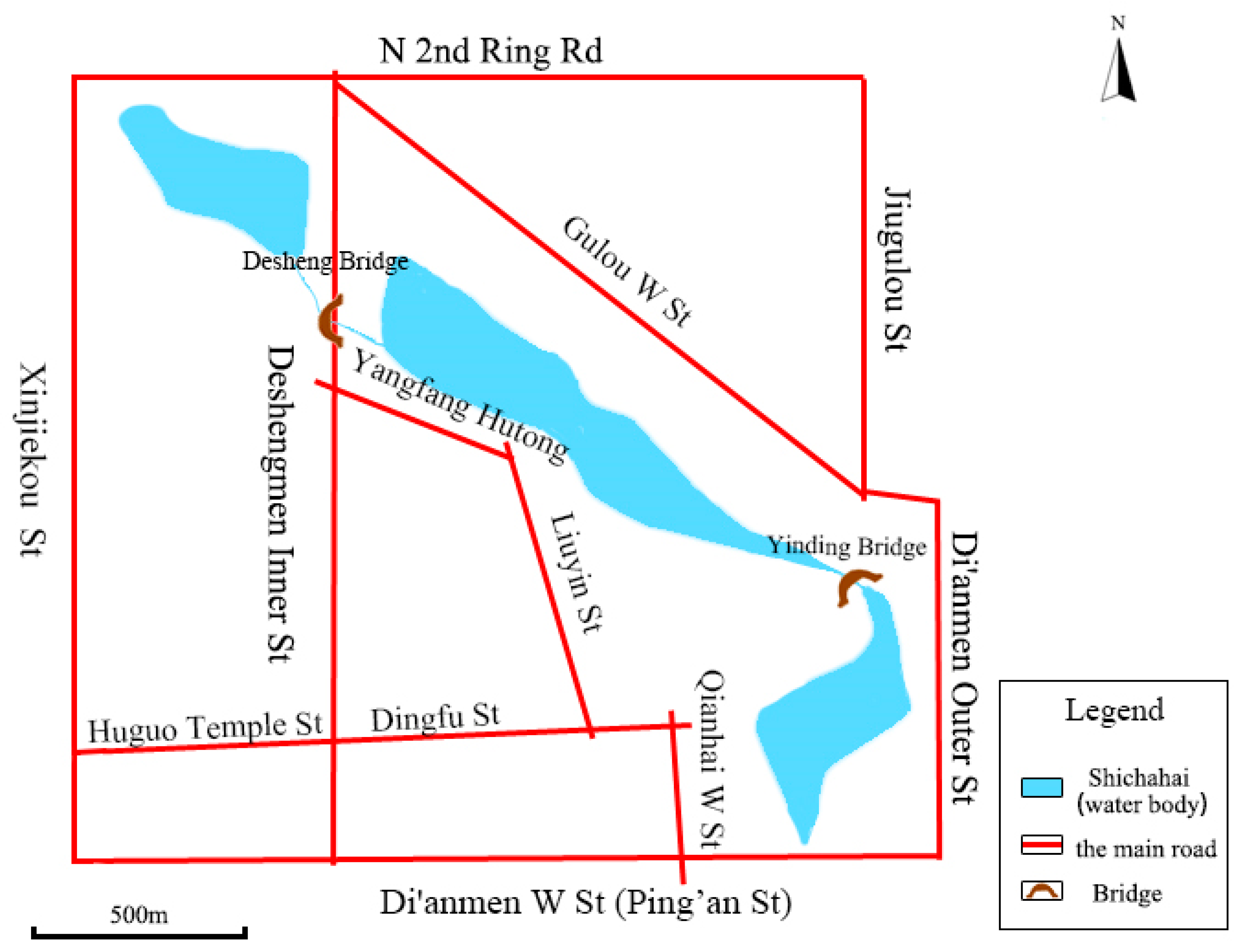
Urban tissue is a synthesis of all the components [1]. The fabric of the city can be seen as the texture of an organic body. If these textures develop too quickly or excessively, they will create a disorder that disrupts the organic body [2]. In general, scholars agree on the existence of urban texture, and more research on the street texture began to emerge. Some literature argues that car prioritized traffic mode has become a major issue in the old city, interrupting the urban public life and the traditional street texture. Through the case study of Zurich, Chen points out the pedestrian prioritized traffic system ensure the original urban tissue in the old city and respects nature, history and culture [3]. Some literature measures and compares the trends (orientations) and lengths of streets in the historical part of the city and in the new part of the city to quantify their textural (morphological) differences and similarities [4]. Choi argues that urban centers have certain common morphological attributes during different formation and development periods. He also mentions that finding and using planning elements of historical city is an important urban planning tool for building sustainable cities [5]. Other literature discusses the role of continuation of the original urban fabric and culture in community renewal and redevelopment [6]. From the aspect of the building density, urban texture can be considered as the figure-ground relationship. From the spatial perspective, urban texture is the urban spatial structure composed of various elements [7]. Overall, these literatures suggest that urban fabric plays a fundamental role in preserving urban cultural heritage, maintaining regional personality, and rejuvenating local vitality. It is also an important means to manage urban spatial structure [8].
With the advent of the automobile era and the social and economic globalization, the urban development in China began to converge between cities. In the process of the natural evolution of neighborhoods, the old downtown districts have seen signs of decay due to deindustrialization (such as silk industry and shipping industry), resulting in a rapid decline of the vibrant street life. These new circumstances also lead to the changes of the original urban fabric in the historic districts, reflected in the destruction of street texture and the gradual loss of the historical features [9].
Realizing this, China clarified the concept of historic and cultural districts in the amended version of People’s Republic of China Cultural Relics Protection Law in 2002. The voice of protecting the historic street texture has become increasingly loud [10].This new version promoted the protection of the historic neighborhoods at the national level. The scholars analyzed the characteristics of the existing streets, in order to find the cutting point to integrate the modern architecture into the historical neighborhoods [11]. In addition, they proposed the methods to distinguish between structural relics and factor relics, allowing the historical urban fabrics to coexist in the new urban order [12,13] for the creation of unique urban character [14]. In the process of urban conservation, China faces greater pressure than anywhere else in the world for preserving the traditional urban fabric [15].
Based on the concept of urban refinement management, some literature emphasizes the street texture as an evaluative element for urban space quality. One of researches analyzes the relationship between urban transportation and urban structure and elaborates the importance of appropriate block size, continuity of urban fabric, public space node network, and walkability etc. [16]. One of the most studied topics is spatial forms and road structures. These studies mainly focused on the application of street texture analysis and design in enhancing neighborhood vitality, planning the layout of urban landscape [17], and improving walking pleasure [18].
To echo with these studies, this paper focuses on the evolution of street texture in the traditional districts in China by using the spatial syntax theory. The Shichahai District in Beijing was selected as the study area. The district is the epitome of the ancient capital city and the ideal example of the historic districts in China. By analyzing the changes of structure and form of the Shichahai District from Yuan Dynasty to nowadays, this paper emphasizes the role of sustainable development in preserving the original street texture.

3. Study Area

The Shichahai District is located in the northwest of Old Beijing, a historic and cultural district adjacent to the Forbidden City. According to the plan of Shichahai District issued by The Committee of Planning and Land Resource Administration of Beijing, the district is demarcated as North Ring II to the North, Di’anmen West Street to the South, Gugulou Street and Di’anmen Outer Street to the East, and Xinjiekou Street to the West. It has a total area of 301.57 hectares and 33.6 hectares of which are water bodies. The district alone accounts for 30% of the total area of the twenty-five Historic Cultural Preservation Areas in Beijing (1038 hectares). There is population of 63,600 residents according to the 6th National Population Census in 2010 (Figure 1).
The Shichahai District is the largest historic and cultural districts in Beijing. Its main street texture was formed during the Yuan Dynasty, and it survived the Ming Dynasty, the Qing Dynasty and the modern period. The District combines traditional residence, scenic tourism and local commercial activities and it has distinctive features of Beijing folk custom and unique natural landscape [19]. Thus, the Shichahai District is the carrier of historical and cultural inheritance and display, and a major hub for tourism, business, and cultural exchanges.
In 2000, Shichahai was the first district that was approved as Historic Cultural Preservation Areas in Beijing. In 2002, the concept of Historic Cultural Preservation Areas was replaced by the Historic and Cultural Districts. Accordingly, the studies on Shichahai District took a cultural turn. The local culture of Shichahai is representative of Beijing culture, which is a combination of royal, celebrity and civic culture. In fact, Shichahai area has been known as a commercial and a recreational district since the Ming Dynasty. Thus, it is known for its recreational culture. However, the traditional characteristics of local culture in Shichahai are fading away due to urban renewal and globalization [20]. Recently, People became more aware of the contradiction between urban modernization and the preservation of the ancient capital city. They called for the protection of the historic architecture and the green space [21]. In the face of westernization of the Shichahai District, a gradual and organic model was applied, with the hope that the original material space will be preserved to the highest degree [22]. In addition, the intangible cultures of the Shichahai District, such as place identity, attachment, and aesthetic values towards local landscape can help people reimagine the place through the eyes of the ancient intellectuals and further form the sensing of place [23].

4. Method and Data

4.1. Space Syntax Research

Space syntax is a term that emerged in the 1970s, used to describe theories and techniques concerning the relationship between space and society [24]. It is proposed that clues to the feature of individual motivation and cognition may be implicit in space syntax theory, it can help to understand the individual level mechanisms [25]. Streets are the backbones of the city’s spatial configuration, and are the most active and fundamental elements of urban texture. In the book Space is the Machine, Hillier examined the concept of configuration from the perspective of spatial syntax theory. Configuration refers to a system of relationships. These relationships are relatively independent. Yet each of them is determined by all the other relationships [26]. The concept of configuration emphasizes the relevance of each spatial element to one another. The more accessible spaces will tend to attract a higher rate of pedestrian movement than other segregated spaces [27]. The method of quantifying the configuration is formed through the diagram based on the topological calculations of a series of variables, which illustrates the relationships between each spatial element. These variables quantitatively describe the relationships and characteristics between each spatial element, and between individual spatial element and the entire spatial structure. For integrating the method of topology computation and space perception research mainly based on visibility analysis, space syntax is a method that is used to quantify space configurations [28]. Therefore, space syntax is a theory and a methodology to examine, quantify and evaluate spatial morphology [29]. Furthermore, this research use space syntax to abstract the street space of Shichahai District as a line segment, and quantifies and illustrates the relationship between each street.

4.2. Data

In the study of the historical evolution of streets in the Shichahai area, we first collected the historical maps including the four historical periods: the Yuan period, the Ming period, the Qing period, and the current period (Figure 2).
In order to examine and compare the status of four stages of the Shichahai District, the maps were digitalized by using the axis model. The axis model is constructed by abstracting the network of city streets in real space into a linear network with the minimum and longest straight lines. The range of this linear network is centered on the study area. The network also includes a buffer zone as large as possible. The boundary of the study area is not necessarily the end of the road, nor the edge of the city. Therefore, the purpose of establishing the buffer zone is to demonstrate the link between the streets in the study area (especially the streets at the edge of the study area) and other streets. The axis model during the Yuan period was constructed based on the scope of the capital of the Yuan Dynasty. The model of the Ming Dynasty was constructed solely based on Shichahai and the surrounding area due to the map restrictions. The model during the Qing Dynasty and the present stage were constructed within the scope of Second Ring Road and north of Chang’an Street. After the CAD linear base map was drawn based on the spatial syntax model, it was then converted to the axis model by using the Dethmap software (Figure 3).

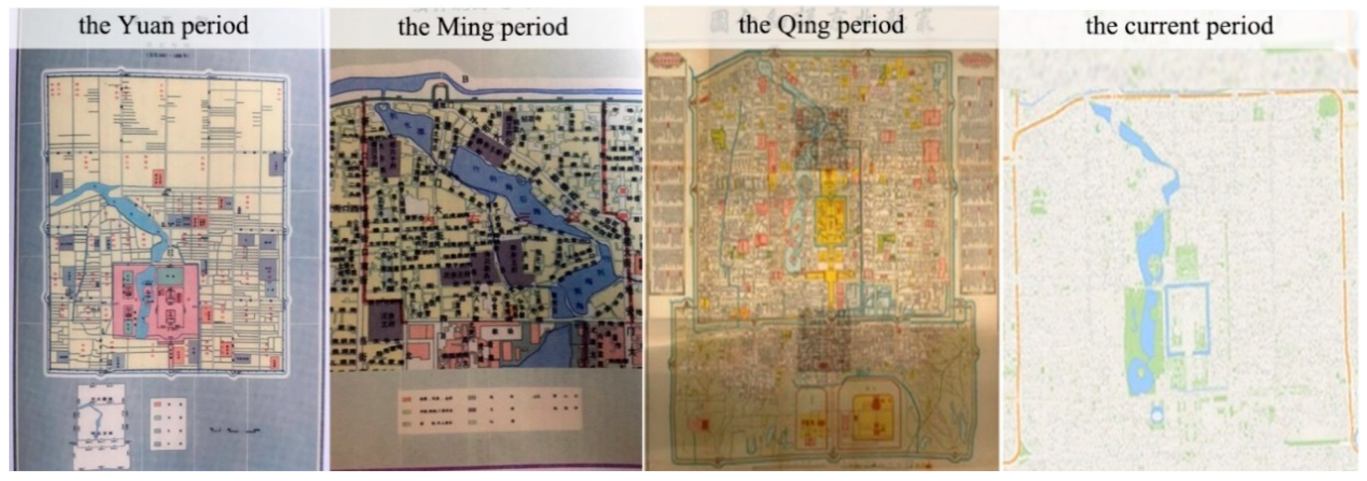
5. The Spatial Evolution of the Street Texture in the Shichahai District

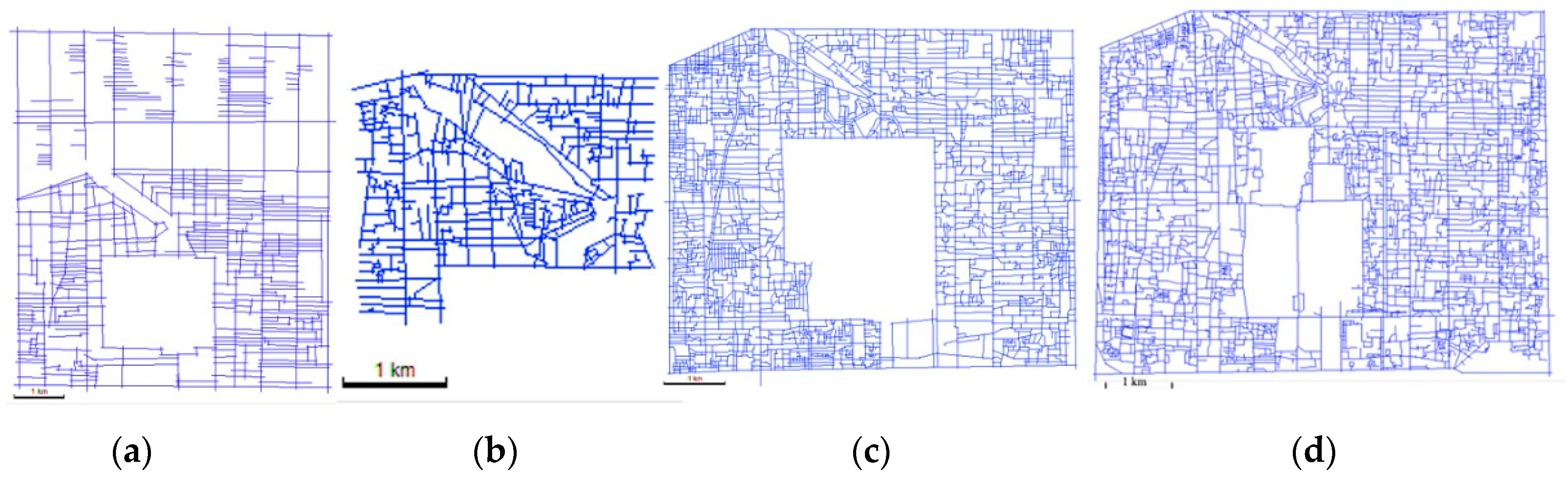
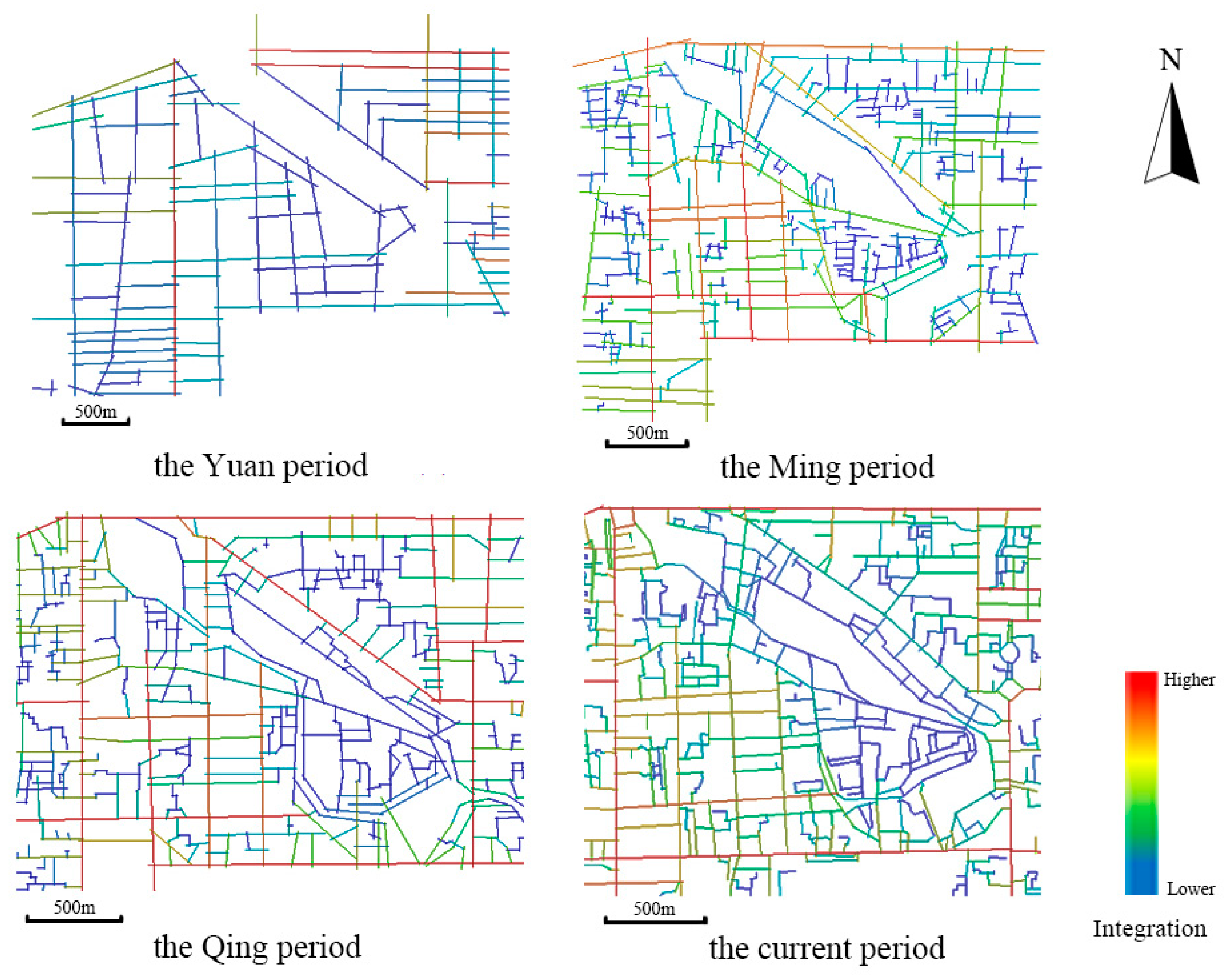
5.1. The Evolution of Main Street Structure

The hierarchy of the street system is reflected by the width and length of streets and lanes. For example, the wider and longer the streets are, the higher their hierarchical orders are. Naturally, these higher grade streets are the main road in the area. The mutual support of these main streets constitutes the basic framework of this area, thus forming the unique local street structure (Figure 4).
The basic street structure in Shichahai was shaped during the Yuan Dynasty and still remains till today, including the boundaries to the east and the west, the oblique street in the northeast, and the main streets in the southeast. During the Ming Dynasty, the northern boundary extended westwards and met with the western boundary. It was only after the founding of the People’s Republic of China that the southern boundary was extended to intersect with the western boundary, forming a complete closed area, which laid out the main structure of the Shichahai Historic and Cultural District seen at the present stage (Figure 5).
Looking at the street fabrics in the Shichahai District longitudinally during the Yuan, Ming, Qing Dynasties and the present stage, one would notice that the main structure of streets and lanes had certain changes but they are not obvious. The inheritance and continuity between these four stages are evident. The street structure in the latter stage is the result of overlays of the street structures in the previous eras. Through the historical inheritance and continuity, the present boundaries of the Shichahai Historic and Cultural District are North Second Ring Road, Jiugulou Street, Di’anmen Outer Street, Ping’an Street, and Xinjiekou Street. Also, the Shichahai area’s main street structure are supported by Central Gulou West Street, Deshengmen Inner Street, Yangfang Hutong, Liuyin Street, Qianhai West Street, Huguo Temple Street, and Dingfu Street (Figure 5).

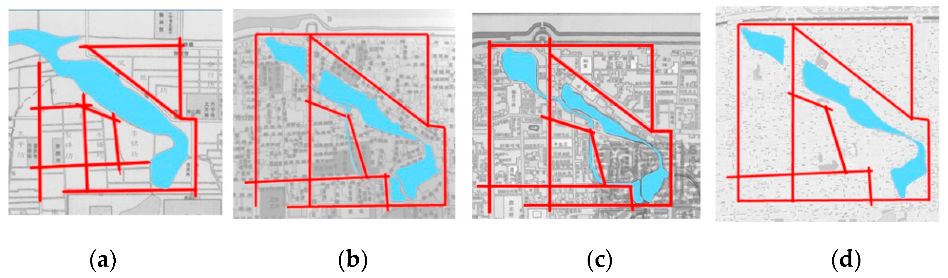
5.2. The Evolution of the Street Integration

Integration is the most widely used variable in the spatial syntactic analysis. It represents the degree of spatial agglomeration or dispersion in the system. It describes the centrality of a spatial unit, and the accessibility and connectivity between each local line segment and the global linear space as a whole. A high degree of integration means the line segment (or a combination of these line segments) is highly accessible across the entire region [26]. In the same region during different historical periods, the location of the highest degree of integration changes, reflecting the historical evolution of this region.
As is shown in the integration axis diagram of the Shichahai Historic and Cultural District in the four stages (Figure 6), the warmer the color is, the higher the degree of integration is, and vice versa.
(1)
During the Yuan Dynasty, the now eastern part of the North Second Ring Road (integration 2.68) and now Xinjiekou Street (integration 2.67) had the highest degree of global integration. Now Jiugulou Street (integration degree 2.31) and the intersection of the east section of Ping’an Street and Di’anmen Street (integration level 2.44) has a relatively high degree of integration, suggesting a high accessibility.
(2)
During the Ming period, the streets with high integration degree were clustered in the southeast of the Shichahai District. Now Deshengmen Street (integration of 2.11), Huguosi Street, and Dingxiang Street (integration of 2.18) were significantly improved. Meantime, the two east-west streets in the southeast connected the two streets with high integration degree (now Xinjiekou Street, Deshengmen Street), which improved their own integration degree as well.
(3)
During the Qing Dynasty, the highly integrated streets were concentrated in the northeast and southwest of the Shichahai District. The eastern boundary, now North Second Ring Road (Integration 2.18), Jiugulou Street (integration of 1.96), and Dianmen Street (Integration of 1.99) were improved. Meanwhile, now West Gulou Street (integration degree of 1.92) connected three high integration streets (the now Deshengmen Inner Street, North Second Ring Road, and Jiugulou Street), thus significantly improved its own accessibility. In the southeast of the Shichahai District, now Hucang Hutong, Cotton Hutong, Luoer Hutong (The degree of integration 1.94), and Songshu Street (integration of 1.86) have improved their accessibility by running through three east-west hutongs with high accessibility.
(4)
At the present stage, Deshengmen Inner Street (Integration of 1.80-1.61) and Gulou West Street (Integration of 1.45) have withdrawn from high integration areas. The surrounding streets in the area have become highly integrated areas: North Second Ring Road (Integration 2.20), Jiugulou Street (Integration 1.96), Di’anmen Street (Integration 1.99), Ping’an Street (Integration 2.13), and Xinjiekou Street (Integration 2.20).

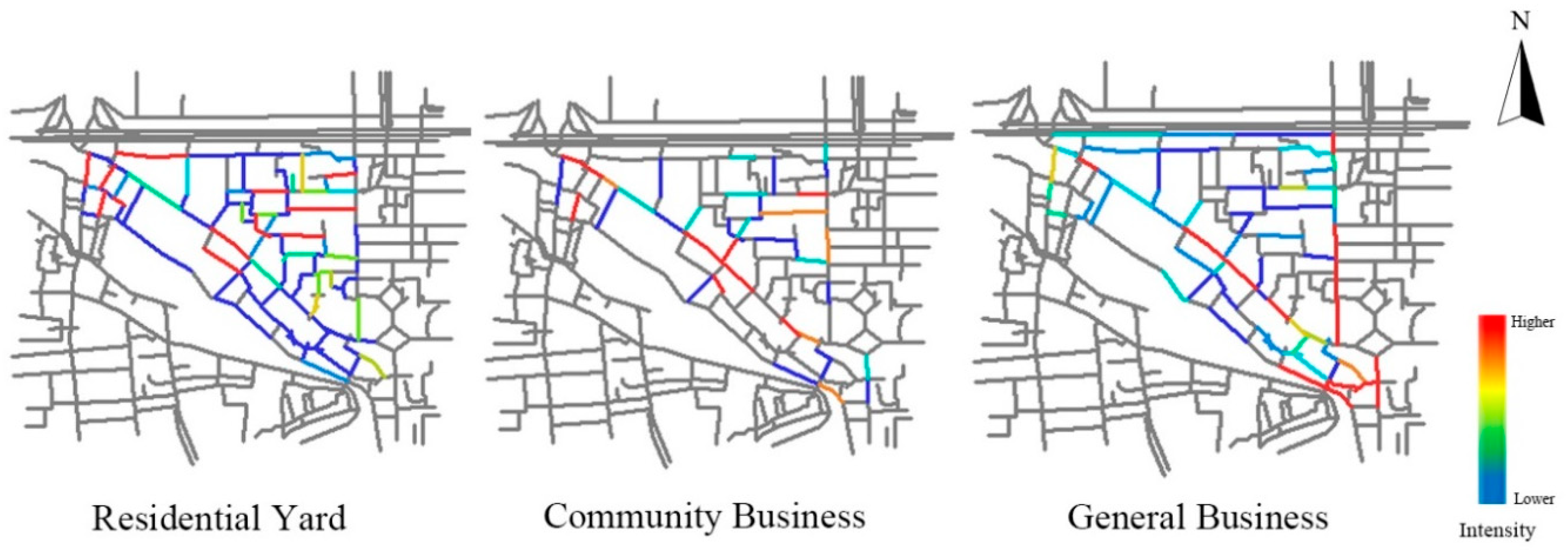
5.3.Preservation of Mixed Land Use Pattern

Based on the current Shichahai Historic and Cultural District segment model, field surveys were conducted to collect land use data along the streets in the study area. It was observed that the street facades were mainly used for three purposes: residential courtyard, community-level business, and general business. What distinguish community-level business from general business are the level and the scope of their service. The community-level business has smaller service radius and they mainly target local residents. These businesses include non-staple food stores, water stations, retail stores, shoe repair, and locksmith stores. In contrast, general commercial business has larger service radius and higher service level. They target broad customer base beyond local residents. These businesses include supermarkets, bars, hotels, and souvenir shops. Figure 7 illustrates the geographical distribution of these three types of land use intensity in the Shichahai District.
Different colors indicate the intensity of street frontages used as “residential yard”, “community business”, and “general business” respectively. Warm color indicates high intensity of a particular land use type, whereas cold color indicates low intensity. Gray color indicates that there is no such type of land use on the street.
In order to explore the relationship between land use and travel mode choice, we selected 500-m walking radius(R500) and 2000 m driving radius(R2000) to analyze the degree of choice, which reflects the shortest topological path between any two spatial units within a region. In general, the cold color represents lower degree of choice, whereas the warm color represents the higher degree of choice. The high degree of choice suggests high potential for transportation volume and better public space (Figure 8).
On the 500-m walking radius, the streets with a high degree of choice in the investigation area are mainly distributed on short lanes. These streets account for a high proportion in the study area, indicating that this area is pedestrian friendly and has a high potential for pedestrian traffic. On the 2000-m driving radius, the streets and alleys with high degree of choice are mainly distributed in North Second Ring Road, Jiugulou Street, Di’anmen Outer Street, Gulou West Street and Deshengmen Inner Street. This suggests that the interior of the Shichahai District is not scientifically suitable for driving, and the traffic volume at the edge of the study area are much higher than that in the interior of the study area. Therefore, the motor vehicles should be forbidden inside the district, whereas pedestrian travels should be promoted in order to create slow space that encourages people to stay longer.
Comparing the land use pattern and the degree of choice, we have made the following observation:
(1)
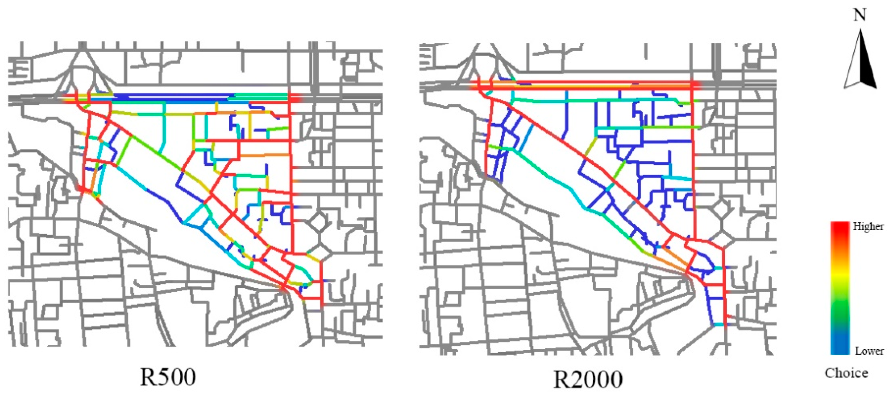
In the distribution of residential courtyard, we found almost every street and alley contains residential land use. In addition, by comparing the distribution of the residential courtyard with the travel mode (Figure 8), we found that the residential land use are mostly concentrated on the streets with moderate or high degree of choice by walking, and streets with low degree of choice by driving. This finding suggests that the streets with moderate pedestrian flows and few automobile traffic flows are mostly located in the residential areas.
(2)
We found only half of the streets and alleys have community-level businesses land use. The distribution of community commercial land use is also related to the distribution of residential courtyard. This is due to the locational factor of community-level businesses, which has a relatively small service radius and low service level. Mainly targeting local residents, the streets and alleys with large number of community-level businesses are nestling within the residential areas. In comparing the distribution of the community-level businesses and the travel mode, we found that the streets with high concentration of community-level businesses overlays with the areas with high degree of choice by walking. Thus, these streets are pedestrian friendly and have relatively high level of pedestrian traffic flows.
(3)
In terms of the general business, they are mostly concentrated in the north section of Deshengmen Street and Gulou West Street and Jiugulou Street. These streets have both high degree of choice by walking and by driving. This suggests that these streets with double-high degree of choice meet the demands for both pedestrian and automobile traffic flows.
(4)
It is worth noting that the distribution of general businesses is not directly proportional to the degree of choice. The agglomeration of commercial businesses is near the Yinding Bridge and Desheng Bridge. Because of the unique locational advantages, as the only two cross-water paths, the bridges converge the pedestrians traffic flows of both sides of the water body. In addition, the limited area of the bridges slows down the traffic speed in the region. For example, the width of the street near the Yinding Bridge is between 6–15m, which is suitable for the pedestrian flows. At the same time, the traffic on the bridge has large crowd of pedestrians, indicating that the areas with high degree of choice by walking are very attractive to general businesses.

6. Conclusions and Discussion

6.1. Conclusions

(1)
Street fabric. Living through the Yuan, Ming, Qing Dynasties and the modern age, the internal structure of the Shichahai Historic and Cultural District has been relatively stable. The main street structure in the four periods has certain changes but they are not major. The spatial pattern of the region is dominated by chessboard layout, and the area near the water body is affected by the contour of the water body, forming a skewed street. Instead, the inheritance and the continuity of the street fabric between the four dynasties are evident. The street structure in the later stage was a reflection of street features of the previous eras.
(2)
Street accessibility. According to the space syntax research, streets with higher integration degree have better accessibility and higher rate of pedestrian flows. From the Yuan Dynasty to the present time, the streets and alleys with high accessibility in the Shichahai area have shifted, due to the changing transportation mode from horse-drawn carts to motor vehicles, compounded by the evolving street structure. The changing function of the water body also affects the degree of integration of each street. During the Yuan, Ming, and the Mid-Qing period, Shichahai area was the hub of Beijing water system mainly for trade and material exchanges with South China. The wharf and warehouse area had a higher accessibility. Nowadays, the motor vehicle-led transportation mode extended the streets with high degree of integration to the main street of the city, such as North Second Ring Road, Di’anmen Street, Ping’an Street and Xinjiekou Street.
(3)
Pattern of land use. The Shichahai Historic and Cultural District has distinct characteristics of self-succession. This research found that the potential of pedestrian flows are much higher than the automobile flows within the district. The pedestrian oriented streets are also featured by mixed land use pattern. The streets for residential courtyards are mostly low grade streets characterized by narrower street width and a smaller amount of traffic flows for both pedestrians and automobiles. The streets with heavy community-level businesses are usually tightly nesting within residential areas. They usually have moderate street widths and high intensity of pedestrian traffic flow. In comparison, the general business land use has a high demand for both pedestrian and automobile traffic flows. Thus, we suggest that the future planning of the Shichahai District rationally follows the land use distribution pattern in the area.

6.2. Discussion

Hiller argues that space syntax research has tried to link the detailed spatial morphology of cities to observable functional regularities. All cities are pervasively ordered by geometric intuition, so that both the forms and the functions of the cities can be understood with insight into the distinctive emergent geometrical forms [30].
By analyzing the geometrical forms of street of the Shichahai District, we argue that the historic and cultural districts in cities are significant places for breeding and displaying the tangible and intangible cultural heritage. These districts can help urban planner and local government acknowledge and understand the relationship between the street fabric and street function, as well as the role of the geometrical forms in how we understand cities and how we create them. They are not barriers to the progress of urban modernization, but rather, a historical and cultural reserve, a showcase of urban progress, and fertile soil for social and cultural development. Meanwhile, the urban modernization and rise of automobile transportation mode in China exert major influence on the structure and vitality of historic districts.
Cities should activate the vitality of these historic and cultural districts, by making them not the burden of urban development, but new growth points of urban prosperity. We must pay attention to the sustainable development of historic and cultural areas in the process of urban modernization, and rethink about the ways to achieve the integration of historical and cultural heritage and modern built environment, to preserve the integrity of a city’s historical context and continuity, and to strive to retain the memory of the city.

Author Contributions

J.Z. (JingyuZhang): Writing-original draft; J.Z. (JingqiuZhang): Writing-review & editing and Funding acquisition; S.Y.: Writing-review & editing; J.Z. (JiayingZhou): Visualization.

Funding

Supported by The National Key Research and Development Program (Grant No: 2017YFB0503605); National Natural Science Foundation of China (Grant No: 41771187).

Conflicts of Interest

The authors declare no conflict of interest.

References

  1. Kropf, K. Urban tissue and the character of towns. Urban Des. Int. 1996, 1, 247–263. [Google Scholar] [CrossRef]
  2. Wang, Z. Organic growth theory and reflections. J. Tsinghua Univ. (Philos. Soc. Sci.) 1997, 2, 77–82. [Google Scholar]
  3. Chen, Y. The experience in the protection and development of the ancient city of Zurich. Planners 2004, 2, 50–53. [Google Scholar]
  4. Mohajeri, N.; Gudmundsson, A. Analyzing the variation in street patterns: Implications for urban planning. J. Archit. Plan. Res. 2014, 31, 112–127. [Google Scholar]
  5. Choi, M.A. Analysis of traditional urban morphology of Korean contemporary city and institutional measures for preservation. KIEAE J. 2014, 14, 47–59. [Google Scholar] [CrossRef]
  6. Wang, J.Q.; Cao, Y.; Sun, Y. The practice of improving the vitality of old urban communities. Beijing Plan. Rev. 2017, 2, 52–57. [Google Scholar]
  7. Yang, J.Y.; Sun, Y.; Deng, D.R. The suitable layout of public facilities: Nanjing’s Binjiang new city. Planners 2010, 4, 19–24. [Google Scholar]
  8. Xu, D. On City texture: The important theme of the civil spirit’s. Mod. Urban Res. 2007, 2, 23–32. [Google Scholar]
  9. Ruan, Y.S.; Cai, X.F.; Yang, H.W. Rehabilitating texture reshaping style and feature—Study on the improvement of style and feature of east traditional commercial street block of Nanxun. Urban Plan. Forum 2005, 4, 53–55. [Google Scholar]
  10. Zhang, Z.G. Conservation and development of Chinese historic city. Archit. J. 2006, 12, 26–29. [Google Scholar]
  11. Yang, J.Y.; Tan, Y.; Wu, M.W. Urban design study of traditional urban texture: Practice and exploration of nanbuting block in Nanjing. City Plan. Rev. 2009, 12, 87–92. [Google Scholar]
  12. He, Y.; Li, J.S. Urban renewal under a postmodemism perspective. Urban Plan. Forum 2008, 2, 99–103. [Google Scholar]
  13. Wang, D. The street that shouldn’t be disappeared—Analysis of the relationship between streets and architectural space in core area of Kunming city. Archit. J. 1999, 8, 29–31. [Google Scholar]
  14. Zhang, J.; Deng, X.; Yuan, L. Searching for new city building types to weave the city with Jinan as a case. City Plan. Rev. 2004, 12, 47–52. [Google Scholar]
  15. Whitehand, J.W.R.; Gu, K.; Whitehand, S.M. Urban morphology and conservation in China. Cities 2011, 28, 171–185. [Google Scholar] [CrossRef]
  16. Sun, T.Y. Open residential community and the construction of urban pedestrian street system. Urban Archit. 2016, 22, 47–51. [Google Scholar]
  17. Zhou, Y.B.; Wen, J.G.; Yu, S.Y. Street landscape design based on traditional small town texture. Dev. Small Cities Towns 2010, 12, 87–89, 99. [Google Scholar]
  18. Li, C.; Huang, Z.J.; Zhu, S.S. An investigation on pedestrian pleasure in Shichahai, Beijing. Planners 2014, 4, 112–118. [Google Scholar]
  19. Bian, L.C.; Jing, Z.J. Some Thoughts on Conservation Planning of Historic Area. City Plan. Rev. 2005, 9, 44–48, 59. [Google Scholar]
  20. Chen, L.; Zhang, W.Z. The change and reconstruction of local culture in response to urban renewal and globalization: A case study of Shichahai historic district. Prog. Geogr. 2010, 29, 649–656. [Google Scholar]
  21. Guo, Q.; Chen, L.B.; Li, X. The history vicissitude of shencha lake temple garden in Beijing. Mod. Landsc. Archit. 2008, 6, 36–39. [Google Scholar]
  22. Liu, M. Study on the elements of conserving the whole characteristics of historic cities’ landscapes. Urban Probl. 2010, 8, 54–58. [Google Scholar]
  23. Zhou, S.Y. On the spiritual images of a city from its local literatures—Take Shichahai historical district as an example. Soc. Sci. Beijing 2016, 1, 4–12. [Google Scholar]
  24. Dalton, R.C.; Hoelscher, C.; Turner, A. Understanding space: The nascent synthesis of cognition and the syntax of spatial morphologies. Environ. Plan. B Plan. Des. 2012, 39, 7–11. [Google Scholar] [CrossRef]
  25. Penn, A. Space syntax and spatial cognition. Environ. Behav. 2001, 35, 30–65. [Google Scholar] [CrossRef]
  26. Hillier, B. Space Is the Machine: A Configurational Theory of Architecture; Cambridge University Press: Cambridge, UK, 2007; pp. 111–138. [Google Scholar]
  27. Bafna, S. Space syntax: A brief introduction to its logic and analytical techniques. Environ. Behav. 2003, 35, 17–29. [Google Scholar] [CrossRef]
  28. Zhang, Y.; Wang, J.G. Rethinking space syntax. Architect 2004, 3, 33–44. [Google Scholar]
  29. Hanson, J. Decoding Homes and Houses; Cambridge University Press: Cambridge, UK, 1999. [Google Scholar]
  30. Hillier, B. Studying cities to learn about minds: Some possible implications of space syntax for spatial cognition. Environ. Plan. B Urban Anal. City Sci. 2012, 39, 12–32. [Google Scholar] [CrossRef]
Figure 1. The scope of case study area.
Sustainability 10 02343 g001
Figure 2. Shichahaihistoric and cultural district map from Yuan period to the current period. Source: Historical Atlas of Beijing, edit by HOU Renzhi, 1988; Google Map.
Sustainability 10 02343 g002
Figure 3. Maps of axis model of old Beijing from the Yuan period to the current period. (a) the Yuan Period; (b) the Ming Period; (c) the Qing Period; (d) the Current Period.
Sustainability 10 02343 g003
Figure 4. The evolution of the main street structure in the Shichahai Historic and Cultural District. (a) the Yuan Period; (b) the Ming Period; (c) the Qing Period; (d) the Current Period.
Sustainability 10 02343 g004
Figure 5. The main structure of the Shichahai Historic and Cultural District in the current period.
Sustainability 10 02343 g005
Figure 6. Integration changes of streets in Shichahai Historic and Cultural District.
Sustainability 10 02343 g006
Figure 7. Distribution of land use intensity along the street in the study area.
Sustainability 10 02343 g007
Figure 8. The R500, R2000 degree of choice in the study area.
Sustainability 10 02343 g008

