Challenges for the Integration of Water Resource and Drought-Risk Management in Spain


1
Geography Lab, Pablo de Olavide University, 41013 Sevilla, Spain
2
Geography, History and Philosophy Department, Pablo de Olavide University, 41013 Sevilla, Spain
*
Author to whom correspondence should be addressed.
Sustainability 2019, 11(2), 308; https://0-doi-org.brum.beds.ac.uk/10.3390/su11020308
Submission received: 14 November 2018
/
Revised: 26 December 2018
/
Accepted: 4 January 2019
/
Published: 9 January 2019
Abstract
:Droughts are risks characterized by their complexity, uncertainty, and a series of other features, which differentiate them from other natural disasters and affect the strategies designed to manage them. These characteristics highlight the close relationship between drought management and water resources management. The following hypothesis is raised in this study—unsatisfactory integration of a drought-risk and water resources management strategies, increases the vulnerability to drought. To corroborate this hypothesis, the Spanish case was analyzed, where droughts are a recurrent phenomenon, due to the Mediterranean climate. Starting from the Intergovernmental Panel on Climate Change (IPCC) framework, which has been proposed to characterize vulnerability as a function of exposure, sensitivity, and adaptive capacity, this study analyzed the vulnerability in the Spanish River Basin Districts, through—(i) the integration of the predictable effects of climate change and the increased risk of exposure in hydrologic planning; (ii) the pressure on water resources that determines the sensitivity of the systems; and (iii) the development and implementation of drought management plans as a fundamental tool, in order to adapt before these events occur. The results showed that despite important advances in the process of conceiving and managing droughts, in Spain, there are still important gaps for an adequate integration of droughts risk into the water resource strategies. Therefore, despite the improvements, drought-risk vulnerability of the systems remained high.
1. Introduction
When we talk about drought it is important to differentiate between drought as a natural phenomenon and drought as a risk. As a natural phenomenon, drought refers to the levels of rainfall dropping below normal, for one area, during a set period [1]. By contrast, drought as a risk refers to the effect that the decreased rainfall may have on the available water resources trying to keep up with the demand [2]. In the same way, when we talk about the relationship between drought and water management it is also important to highlight the differences between drought (which is a temporary and natural phenomena), water scarcity (which is permanent and anthropogenic), and water deficit (which is temporal and anthropogenic) [3]. A period of drought can lead to water deficit situations that make it difficult to meet the water demands. So, this situation could be prevented and adequately managed to avoid restriction in use. Scarcity, finally, refers to a permanent situation of water deficit, where demand is greater than the available resources and structural measures that are needed to revert this situation [4].
Droughts understood to be risks are the result of a complex process which includes different natural and human factors, in continuous interaction, and operate in different spatial and temporal scales [2]. On the one hand, a drought depends on the atmospheric and hydrologic processes, which vary depending on location and topography, which determine the spatial and temporal distribution of rainfall, and also the effectiveness, intensity, and number of rain events that occur [5]. These processes are also important in the incidence of drought factors, such as geology and vegetation, which determine the capacity of water retention, infiltration, runoff, evapotranspiration, etc., and which ultimately determine the amount of water available to meet demands. Droughts also have important spatial variations and a strong dependence on the context in which it is produced [6]. The level of impact of a drought is also related to the ways in which societies relate to the environment, through the management and exploitation of water resources and the development of strategies and tools to cope with these types of events, which determine the vulnerability of different systems to the onset of a drought period by conditioning their exposure, sensitivity, and ability to adapt.
Like other natural hazards, drought-risk is associated with high levels of uncertainty. Moreover, the role that the human component plays in the lower or greater incidence of this risk by subjecting the systems to high levels of water stress and, thus, high levels of vulnerability, as well as the ability of the human being to intervene in the process and make decisions as the drought progresses, incorporates into the system a type of uncertainty that is typical of human intervention [7].
Furthermore, droughts present a number of characteristics that differentiate it from other natural disasters. (1) The effects of a drought can accumulate over long periods of times and persist for many years [8]. (2) The temporal and spatial limits of drought can often be difficult to determine [9,10,11]. (3) Unlike other natural disasters, the impacts of drought rarely result in structural damage, so impact quantification is much more difficult [10,12]. (4) Water is a basic resource needed for ecosystem maintenance, the majority of productive processes, and life. Droughts impacts are defined by a decrease or absence of this basic resource, hence, the relationship between ordinary resource management and risk management is critical in determining the impact of a drought.
These special characteristics of drought as a risk phenomenon, place drought management strategies under important processes of perception and interpretation. In many cases, perception of drought derives from understanding and managing of the resources.
In cases like that of Spain’s, where drought is an inherent feature of the climate and a period of drought appears approximately every ten years (the most severe episode in terms of economic losses took place in 1941–45, 1979–83, 1990–95, 2004–08, and 2015–18), these drought events affected virtually the entire Spanish territory. In this context, it is essential to perceive and assume the normality of the occurrence of periods of drought and to integrate this into the ordinary water resources management, to reduce vulnerability of the system, against the emergence of this type of phenomenon [13].
As already pointed out, the hypothesis of this work is that a poor integration of a drought-risk in water resource planning strategies, generates an increase in the vulnerability to these risks. Hence, the structure of the paper is as follows. Section 2 explains the main changes in the drought management strategies that have been reached at the institutional level, derived from a change in the perception of droughts towards the assumption of normality of these phenomena, in Spain. Section 3 presents the methodology for analyzing the degree of real application of these institutional and normative changes. Results are then presented in Section 4, followed by a discussion in Section 5, which offers a debate and finally the conclusions.
2. The Evolution of Drought Management Strategies in Spain
In Spain, it rains an average of 650 mm every year (series 1981–2010). However, rainfall levels vary greatly annually, which creates a habitual succession of one or more wet years followed by one or more dry years. There is also an important spatial variability on the Iberian Peninsula, with regions in the northwest receiving excess of 800 mm of rainfall, annually, and the regions in the southeast that barely reach 250 mm. Additionally, rainfall in Spain has a marked seasonality, most of the rainfall is concentrated in the fall and winter months, while summer precipitation is almost nonexistent. This irregularity is due in part to the geographic position of the Iberian Peninsula which is in a transitional zone between two climates (Oceanic, Mediterranean). It is also affected by its size and varied orography [14,15]. This natural irregularity has been the pretext of the country’s hydraulic policy, throughout the twentieth century, which has tried to correct the territorial and seasonal imbalance in water supply by building important infrastructure, such as reservoirs and transfers between watersheds [16,17,18,19,20,21].
Derived from this manner of interpretation of water resource management, Spain’s drought management strategies have been dominated by the crisis management model, as the Ministry of the Environment has acknowledged [22]. From this paradigm, droughts have been interpreted as extraordinary events for which little or nothing could be done. The main tools that have been used for management have focused on the application of reactive and emergency measures, once the impacts are already perceived, usually through the approval of royal drought decrees, which are only used in emergency situations, for the general interest [23,24,25]. Perceptions about drought and insufficient rainfall are keys to gaining a good understanding of drought management and hydraulic policy, in general. This results in unrealistic scenarios which puts the system under severe pressure and increases vulnerability to episodes of drought [13].
Due to its geographical location, drought episodes constitute one of the main natural risks of atmospheric origin in Spain [26]. Drought is a recurrent risk in Spain and a drought or quasi-drought takes place, approximately, every ten years. In addition, climate change models predict an increase in the frequency and intensity of droughts in the Southern European regions [27], and Spain is highlighted as one of the most vulnerable countries in terms of future water availability [28].
For this reason, drought can no longer be regarded as an extraordinary event. This is an approach that promotes the separation of regular water management and drought management—i.e., calculating the supply and demand without taking into consideration the potential periods of drought, and addressing it by implementing mitigation measures, only after the event has become a reality.
The need to reorient the management of droughts towards the risk management paradigm is recognized at the institutional level, although certain reluctance is still evident [28]. In this sense, we can highlight three key milestones that practically coincide with the times that mark the way towards a risk management paradigm. First, the consequences of the drought of 1991–95—with more than 12 million affected—included agricultural losses, which lowered the country’s GDP by 1 percent, and caused considerable environmental damage, which was never evaluated. The management of this drought included as many as twelve drought decrees, five ministerial orders that modified some aspect of the decrees, and two state secretary resolutions that were passed with emergency measures. These measures were the maximum expression of the reactive approach, and as the White Paper on Water recognizes, they were undertaken with little planning and were unable to solve most of the problems caused by the event [28].
Secondly, the initiatives promoted by the European Union that assumed important changes in the interpretation of water risks and drought management. Concretely, the approval of the Water Framework Directive (WFD) (2000) led to important changes regarding water management. For one, the directive moved away from a quantitative focus on the hydraulic paradigm and emphasized the ecological status of bodies of water. Concerning drought management, although it was outside the strict remit of the WFD to deal with extreme meteorological events (none of the articles in the WFD directly addressed the management of such events), the directive aimed to contribute to palliate the effects of flood and drought (Article 1), which paved the way for including drought in planning mechanisms, and adopting preventive and recovery-oriented measures [29]. On the other hand, The publication by the Communication Department of the European Commission, “Addressing the challenge of water scarcity and drought situations”, from the European Commission, was adopted in 2007 (COM (2007) 414), whose objective was to encourage the management of resources and water risks, in order to prevent, and to mitigate water scarcity and drought situations, with the priority to move towards a water-efficient and water-saving economy.
Thirdly, although still reproducing some ideas from the traditional hydraulic paradigm, the National Hydrological Plan Act (2001) included an article (article 27) which demanded the preparation of Special Action Pans during Conditions of Alert and Drought (PES is the Spanish acronym) and Emergency Plans (PEM is the Spanish acronym), for supply systems that serve urban agglomerations with a population in excess of 20,000 inhabitants. This was a unique disposition in the legal corpus of European countries. It also directed the Ministry for the Environment to elaborate a global system of indicators, aimed at predicting drought, which the basin authorities might use as a universal reference. This act was, according to the Ministry, the inflexion point which marked the paradigm shift from crisis management to risk management [2].
However, despite these advances in both the interpretation of drought and the development of new management tools, which were related to a risk-management approach, the integration of risk into the water management strategies and planning was still, in practice, insufficient [24]. As a result of this separation between resource and risk management, systems remained vulnerable to the onset of a period of drought, and the new management tools developed were insufficient to deal with drought-risk. The result was that drought decrees still played a relevant role because they perpetuated, in practice, the ideas of the traditional hydraulic paradigm. This was demonstrated by the publication in 2015 of the ‘Royal Decree Law 356/2015′ for the Segura basin, the ‘Royal Decree 355/2015′ for the Júcar basin, and the ‘Royal Decree Law 10/201′, which adopted urgent measures to palliate the effect of drought, in a number of river basin districts, and modified the Water Act—a modification which was later endorsed as the ‘Royal Decree Law 1/2001′.
3. Materials and Methods
To corroborate this hypothesis—poor integration of water resource management and drought-risk management strategies increases the vulnerability to drought-risk—three aspects were analyzed that were directly related to the three components of vulnerability, proposed by the Intergovernmental Panel on Climate Change (IPCC) [30]. The exposition, defined in the function of the characteristics of the threat, such as, the frequency, magnitude, or duration of a disturbance [31,32,33]; sensitivity, defined by those conditions of the exposed system that make it more likely to experience damage and be adversely affected by a natural hazard [34]; and the ability to adapt, defined as the set of characteristics and capacities of the society that allow it to cope with drought as the phenomenon advances (response in the short term) and also those that are part of a constant process of learning, experimentation, and change in the way to deal with these risks [2].
In the first place, it analyzed the degree of integration of the effects of climate change in the Spanish River basin district plans. The analysis of this variable allowed us to know if the predictable increase of exposure to drought in the ordinary water resource planning was integrated. To analyze this variable, we reviewed all Spanish River basin district plans and analyzed the extent to which climate change forecasts have been introduced on water resources in the future (increased demands, decreased availability of resources, and worsening of the state of water bodies).
Secondly, to characterize sensitivity, the state of pressure on water resources was analyzed, as a characteristic of the ordinary management of resources. Sensitivity determines the hydrological state of the different systems to respond to a period of drought. To analyze this variable, an analysis of the different river basin districts was carried out by using two indicators—the Water Exploitation Index (WEI) and the ecological state of water bodies was measured, according to the provisions of the Framework Water Directive (FWD).
Finally, to characterize the degree of adaptation and preparation to respond to drought-risk, the compliance status was analyzed by Article 27 of the National Hydrological Plan (NHP), which established the obligation to elaborate special plans, for action in alert situations, and the eventual droughts (PES) in in all river basin districts, as well as the emergency plans for those urban supplies with more than 20,000 inhabitants (PEM). This was done by a review of the documents through an analysis of the established obligations and the current administrative state of the different plans.
4. Results
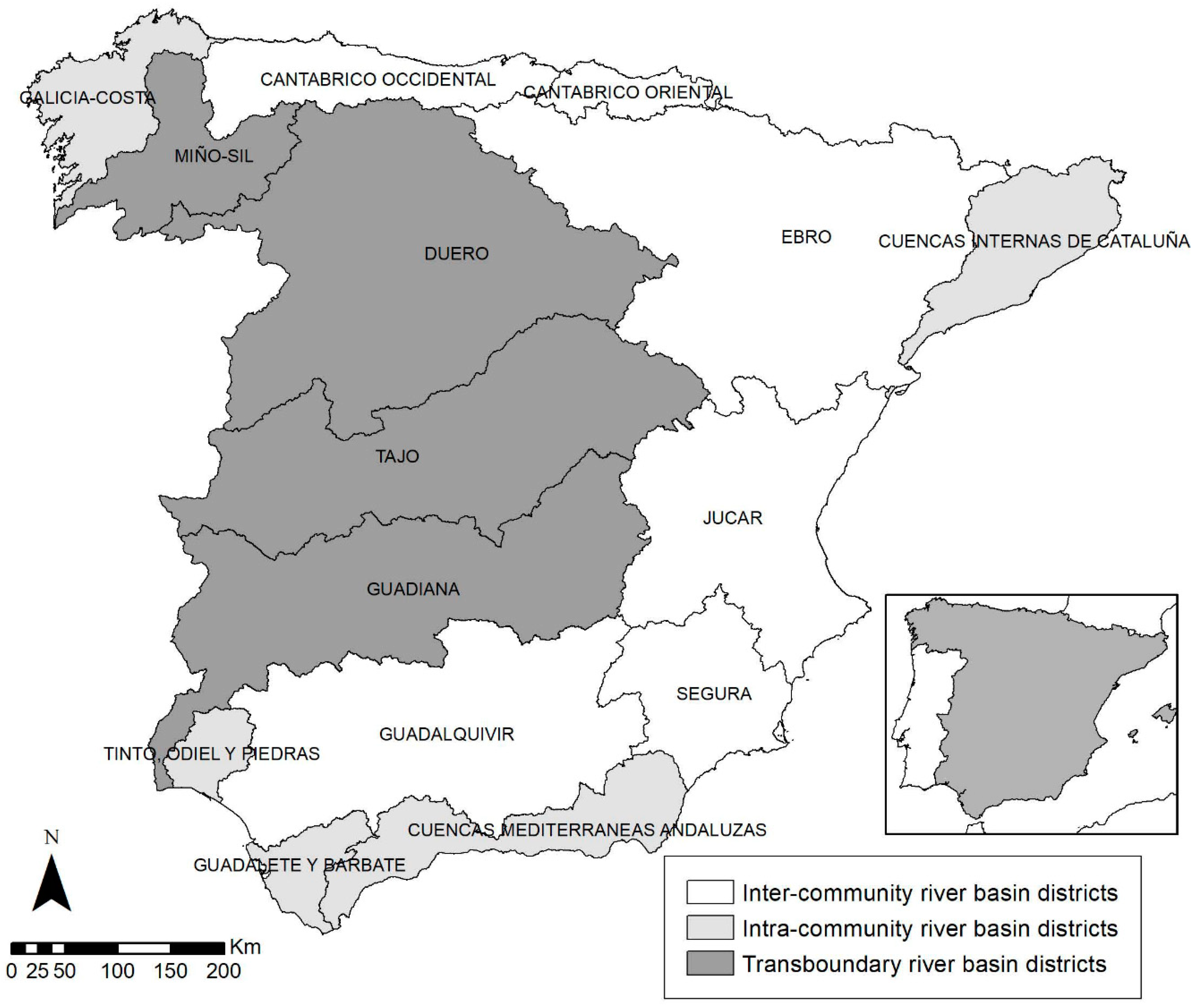
The results of the analysis carried out are presented in connection with the three variables analyzed. The results are presented for each of the Spanish River Basin Districts (Figure 1), so we could carry out a discretized analysis on each of them, for the three variables, and could also do an assessment of the whole country.
Figure 1 shows the differences in the water management administration authorities in Spain (regional governments for the intra-community river basin districts, the Spanish Central Government for the inter-community river basin districts, and the transboundary river basin districts). Due to the different orography and climate conditions, there were also some important differences in the water resources availability, water demands, and the use of non-conventional resources among the different Spanish River Basin Districts (Table 1).
Average precipitation greatly decreased from the northwestern river basin districts to the southeastern ones, with great variation within each of the river basin districts. The use of non-conventional resources was still minor. Desalination plants were in Mediterranean river basin districts, such as C.M. Andaluzas, Segura, Júcar, and C.I. de Cataluña. Reuse of the treated water was broadly distributed and was in continuous growth, in all the river basin districts, but was still minor. The water demands highlighted the importance of agrarian use in most river basin districts: Miño-Sil (73.2%), Duero (91.1%), Tajo (71.1%), Guadiana (89.9%), Tinto-Odiel-Piedras (62.0%), Guadalquivir (88.9%), Guadalete-Barbate (70.0%), C. M. Andaluzas (70.9%), Segura (87.8%), Júcar (79.6%), and Ebro (92.2%).
4.1. Climate-Change Effects on Water Resources
As a result of the fourth report of the IPCC [35] and on the basis of the models of climate change that were published for Spain, in the year 2012, the Public works research and experimentation center (Centro de Experimentación de Obras Públicas, CEDEX) published a series of reports on the evaluation of the effects of climatic change on the hydrological resources and water bodies, for all Spanish River Basin Districts [36]. These works were developed from the regionalized climatic scenarios for Spain, within the framework of the IPCC’s fourth report [35]. The emission scenarios were selected and transferred to all hydrological demarcation plans (SRES A2 y SRES B2) were a part of the set of greenhouse gas emission scenarios, established in the year 2000, in the special report on emission scenarios by the IPCC group (SRES A2: This scenario reflects the situation of non-adoption of measures to reduce emissions; SRES B2: This scenario incorporates reduction measures to alleviate the pernicious effects of climate change).
These reports conclude that climate change will have an impact on rising temperatures, a widespread decrease in rainfall and runoff, and an increase in rainfall irregularities. The consequences of these changes on water resources, according to these reports, will be: (1) Increased evapotranspiration and, therefore, a general increase in consumption and water demands (mainly plant and agricultural demand); (2) reduction of rainfall, runoff, and natural contributions will lead to a decrease in available water resources; (3) worsening of the ecological state of rivers (other types of bodies of water were not evaluated); and (4) increased pluviometry irregularity that would cause an increase in the uncertainty of water availability.
All of these consequences, obviously, negatively impact the vulnerability of the systems for coping with periods of drought in the future, which is exacerbated in the absence of adequate adaptation to the new scenario that climate change poses. In this sense, the consideration and application of climate change forecasts in the planning of water resources in Spain, has been insufficient, as shown in Table 2. Mainly, the Spanish River Basin Districts introduce these considerations weakly and are limited to apply percentages of reduction contained in the Hydrologic Planning Instruction for calculating the resources available in scenarios 2027 and 2033.
Recently CEDEX [37] has published an update on the climate change assessment of water resources and droughts in Spain. Although it has not yet taken the time to incorporate the new conclusions on the effects of climate change on water resources in the river basin district plans, it should be included in the new planning cycle (2021–2027). Unlike the document published in 2010 [36], the new regionalized scenarios for Spain are based on the AR5 (Fifth Climate Change Assessment Report) [38], which introduces updates to the General Circulation Models (GCM), as in the emission scenarios used. The GCM used in the AR5 are called. The General Circulation Coupled Atmosphere-Ocean Models (MGCAO) simulate the dynamics of the physical components of the climatic system (atmosphere, ocean, earth, and ice cap); and the most complete Terrestrial System Models (TSM), and include the representation of several biochemical cycles, such as those involved in the carbon, sulfur, and ozone cycles.
Additionally, the AR5 has defined four new emission scenarios, the so-called Representative Paths of Concentration (RCP), which replace the SRES used in previous reports (SRES 2 and SRES 4). News RCP used are RCP 2.6, RCP 4.5, RCP 6.0, and RCP 8.5. Each RCP is associated with a high spatial resolution database of pollutant emissions (classified by sectors), GHG emissions and concentrations, and soil uses up to the year 2100, based on a combination of models of different complexity of atmospheric chemistry and the carbon cycle (IPCC 2013).
In the Spanish case, the Meteorology State Agency (Agencia Estatal de Meteorología, AEMET) has carried out a regionalization of the climatic scenarios of the RCP 4.5, 6.0, and 8.5, and the CEDEX has used RCP 4.5 (scenario of stabilization of the GHG emissions, where the maximum CO2 concentration in the atmosphere is estimated at 528 ppm) and RCP 8.5 (scenario with very high levels of GHG emissions, where the concentration of maximum atmospheric CO2 is estimated at 936 ppm) for the report on the impact of climate change on water resources and droughts in Spain. The conclusions of the report for the variables, which can determine the availability of water resources in the future, are presented in Table 3.
Estimates in both scenarios show a widespread decrease in rainfall, soil moisture, aquifer recharge and runoff, and an increase in evapotranspiration, for the entire country, which would become more acute as the 21st century progresses. It is true that the RCP 8.5 scenario estimates are more pronounced. An increase in the potential evapotranspiration is also generally seen.
In general, it recognizes a reduction of water resources in the whole peninsula, more intense in the south and in the archipelagos, and a minor reduction in eastern parts of the Iberian Peninsula. This decrease in the availability of resources will result in an increase in the scarcity of water resources to meet demands [39]. In addition, the same report predicts a change in the drought regime. Most climatic predictions show a future in which droughts would be more frequent and intense, blaming the progress of the 21st century for increasing exposure to these kinds of episodes in the future.
The hydrological plans of the different river basin district is to partially incorporate the forecasts of climate change in such a way that scenarios 2027 and 2033 include the decline in the availability of resources (but not the estimates of the increase in evapotranspiration), the consequent increase in demand, and the effects of climate change on the state of the water masses. The usual recurrence of droughts in Spain and the predicted increase in their frequency and intensity make it necessary to incorporate the period of drought’s pluviometry normality and a review of the availability of resources that takes into account the variability of drought periods, as a standard, and not as an exception, in order to make a resource allocation much more adjusted to the actual availability of the resources necessary.
4.2. Water-Stress Level for Different River Basin Districts
In Spain, it usually rains enough to meet demands. Furthermore, the country also has a great regulation capacity (56,000 hm3). However, the mentioned rainfall variability (interannual, seasonal, and spatial) is combined with a growing demand of water for different purposes [39]. In the Spanish River Basin Districts (2015–2021), the total demand of water amounts to 31,355.4 hm3, of which 80.4% of which is agrarian, 15.6% urban, and 4.2% industrial demands [39].
The level of pressure to which the water resources are subjected in the ordinary hydrologic planning determines the response of the system when a drought occurs and negatively impacts the sensitivity of the system. The greater the pressure on water resources the more difficult it will be to meet demands when the availability of resources decrease due to drought. The level of pressure on the water resources in a system of exploitation or river basin district, can be characterized by two variables—the stress to which the water resources are subjected and the state of the water bodies after various demands.
In Table 4, a synthesis of natural contributions is presented (hm3/year). Available resources (hm3/year) were calculated as the natural conventional resource to which non-conventional (reuse and desalinization) was added, also subtracting the transferred flows to other basins and adding those received by transfers from other areas of planning and consumption demand (urban, agricultural, and industrial) (hm3/year). The calculations were done on the official published data of the WEI.
Water Exploitation Index is a widely recognized indicator used to characterize the level of pressure on the water resources of certain territories or river basins [40]. This indicator relates the total use of resources (consumptive and non-consumptive) to the total renewable resources, expressed as a percent. According to Eurostat, WEI values below 10% imply that the analyzed system is not subjected to any form of stress, if the value is between 10–20% it implies a low water-stress level. If the indicator exceeds 20% it is considered to have raised the alarm for water-stress levels, and if it exceeds 40% the system is in severe stress. Another very similar indicator is the WEI+ (which is an evolution of the WEI) and it relates the total amount of resources consumed (consumption with no returns) to the total amount of renewable resources.
Due to the variety of methodologies used in each river basin district to calculate these parameters, we have used two different methods of calculation. First, we used an adaptation of the WEI proposed by García and Martínez (2016) [41]. This entails dividing the total consumption demands (excluding hydroelectric use) between the natural contributions, which results in the quantitative relationship between water availability and human pressure. In addition, the official results presented are the same as that published by CEDEX itself (2017), in which the WEI+ was calculated on the basis of the relationship between the demands of the available resource, which is also expressed as a percentage. The results obtained through the two methodologies (WEI+ and *WEI+) showed similar results for all river basin districts. The main difference lay in the Segura River Basin demarcation, due to the amount of water this area receives from the Tajo-Segura transfer which significantly increases the amount of resources available. For the rest of the demarcations both indexes (WEI+ and *WEI+) present similar values that can be used as a reference to determine the state of pressure on the water resources.
According to the data obtained, only four of the fifteen demarcations analyzed (Cantábrico Occidental, Cantábrico Oriental, Galicia Costa, and Miño-Sil) had levels of stress below 10% which shows that they had little to no water stress. Three demarcations (Duero, Tajo, and the internal basins of Catalonia) had values between 20% and 40%, presenting alarming levels of stress on their resources. The rest of the demarcations had very high values, well above 40%, which indicated severe stress. The average value for all fifteen demarcations was slightly above 31%. Although both values place the entire country in a water-stress alert level, the mean value for all demarcations was skewed by the extreme values of some of the demarcation’s data, which were not representative of the country. If the median value is used, where extreme values do not affect the average as much, a WEI value of 45.4% and a WEI+ value of 46.9% is achieved.
The results obtained show that many of the Spanish demarcations were subject to severe water-stress levels. In addition, the demarcations with higher rates of water stress were also those that had the greatest availability of resources (except Cantábrico Occidental, Miño-Sil, and Galicia Costa) indicating that in most cases it was not a water availability issue but that of excessive pressure on the existing resources.
The other indicator used to characterize the existing pressure on the hydrological resources was the state of the water bodies. Water bodies are a fundamental element which is articulated in the Water Framework Directive (WFD) and in the hydrologic planning. The purpose of the Directive is to reach a good status, for all water bodies, to ensure the adequate supply of surface and groundwater, and to require a sustainable, balanced, and equitable use of water, as stated in Article 1 of the WFD.
Different demands are assigned to the water bodies in order to meet the water use needs of the different sectors. Therefore, the state of the water masses is not merely a goal, but also a condition for adequate water supply to meet the demands. When a period of drought occurs, the qualitative and quantitative status of a water body can be affected and can limit the ability to satisfy demands, either by reducing the amount of available water or by worsening the quality of water. The state of water bodies affects the way in which the water body responds to the decreased precipitation. In Table 5, data on the global state of surface water and groundwater bodies, for each of the Spanish River Basin Districts, are presented and analyzed.
For surface water bodies, 43.4% of the bodies of the water presented had a global status of “worse than good”, while 56.6% had a status of “good”. Duero (70.2% the bodies of water had a “worse than good” status), Guadiana (69.6%), Tinto-Odiel-Piedras (50%), Guadalete-Barbate (54.6%), and Jucar (63.3%) had the highest percentage of bodies of water that did not reach the “good” status; being always above 50%.
For groundwater, 41.4% of the water masses had a “bad” state. Guadiana (80%), Tinto-Odiel-Piedras (75%), Guadalete-Barbate (64.3%), Cuencas Mediterráneas Andaluzas (65.7%), Segura (73%), and Cuencas Internas de Cataluña (64.9%) had waterbody percentages that reached the “bad” global status of above 50%.
Of the 5582 bodies of water analyzed (above and below ground), 41.3% did not reach the “good” overall state. In seven of the fifteen river basin districts, more than 50% of the bodies of water did not reach a “good” overall status (Duero (66.5%), Guadiana (70.2%), Tinto-Odiel-Piedras (51.3%), Guadalete-Barbate (55.8%), Cuencas Mediterráneas Andaluzas (55.9%), Segura (55.9%), Júcar (50.2%), and Cuencas Internas de Cataluña (64.9%).
Both the amount of pressure on water resources and the global state of bodies of water showed a generalized situation of high pressure on the Spanish water resources of the different river basin districts, which increased the sensitivity to suffer impacts (economic, environmental, and social), before the onset of a drought.
4.3. Development and Implementation of Drought Planning
The main tool used to cope with droughts in the risk management paradigm are drought plans, as recognized by the major international agencies [42,43,44]. The theoretical planning of these tools are based on two basic ideas. First, the probability of eliminating the risk does not exist, but can be minimized, and second, planning while anticipating the problem has many advantages: (1) It allows researchers to learn and analyze what causes systems to become vulnerable to periods of drought and how to fix the problem preemptively; (2) it prevents hasty decisions being made in response to the crisis. Therefore, the objective of the drought plans is to determine the arrival and departure of the different drought phases and the specific measures of action necessary for each social phase [11]. Hence, the prevention and gradual adaptation to a drought as it progresses to reduce the economic, environmental, and social impacts.
In Spain, Article 27 of the National Hydrological Plan Act establishes the obligation to prepare special plans of action for alert situations and eventual droughts in all River Basin Districts (PES), and urban supply system emergency plans (PEM).
4.3.1. Special Action Plans during Conditions of Alert and Eventual Drought (PES)
PES are an important step forward in conceptual and operational terms, as it aims to evaluate drought, objectively, and to implement progressive measures with which to prevent droughts from becoming more severe [44].These plans, which must be made by the watershed agencies in each of the river basin districts and must be coordinated with the hydrological demarcation plans, make up the system of indicators and thresholds used to identify the different states of drought (Normal, pre-alert, and emergency), as well as exploitation rules and the measures to be implemented concerning public ownership of water at each stage (Article 27.2. National Hydrological Plan Act).
In any case, the first steps of this new policy have suffered from a number of teething problems. (1) PEM due for 2005 were only published by the inter-regional basins in 2007, while the first-cycle hydrological plans (2009–2015) were published even later (some of them as much as six years late). These hydrological plans must be incorporated into the drought plans, but there is no guarantee that the targets and measures contemplated in both will be compatible. The late publication and inadequate updating of the PEM makes integrating current (but out-of-date) PES (2007) and second cycle hydrological planning (2015–2021), published in late 2015, with up-to-date information concerning resource inventories, demand, and, especially, ecological flows, very difficult. (2) The drought indicators in use are, in fact, indicators of scarcity. While indicators of scarcity may be useful in assessing and comparing supply and demand, they fall short of discriminating between ‘meteorological drought’ (caused by below-average rainfall) and water scarcity related to reservoir and aquifer levels, which depend, to a large extent, on the management model in place, and the usage of water before and after rainfall declined. As such, these plans are little more than contingency plans to address shortcomings in supply, but are largely unrelated to meteorological drought. The WFD permits the temporary deterioration of bodies of water, but only in unforeseeable and exceptional circumstances (Article 4.6. WFD). Adjusting the indicators to ensure that the reasons behind the deterioration of bodies of water are adequately accounted for, is essential for the correct implementation of the WFD.
In 2017, the Ministry of Agriculture, Fisheries, and Food (MAGRAMA) published technical guidelines concerning special drought plans and prolonged drought and scarcity indicators (TG), which established a number of rules for the updating of PES. Certain basin authorities have already published drafts of the updated PES. The revision of PES, which is currently under way, is an opportunity to continue advancing towards a drought-management model, based on prevention, mitigation, and progressive adaptation. We must take this opportunity to discriminate, at long last, between the prolonged meteorological droughts and socially constructed, management-induced scarcity. In addition, we must ensure that the various planning processes, for instance PES and PEM, are better coordinated in the future.
4.3.2. Emergency Plans (PEM) for Supply Systems That Serve Urban Agglomerations with a Population in Excess of 20,000 Inhabitants
These plans are only concerned with urban areas with a population in excess of 20,000 inhabitants, and are, therefore, the responsibility of the authorities in charge of overseeing the water supply. The aim of these PEM is to prevent drought from affecting the urban supply. However, although the deadline for the publication of PES was 2005, only a few have been published and their impact has been, therefore, very limited.
The publication of the new PES draft in December 2017 meant that progress could be assessed, with regard to PEM. These drafts identified two hundred and thirteen supply systems for urban areas, with over 20,000 inhabitants, which are, thus, required to provide a PEM. Only 8.5% of these supply systems have a PEM approved by the relevant PES (2007); 11.3% systems have already delivered their PEM, and this is currently being evaluated by the relevant basin authorities; 9.9% have a PEM in place, but the plans need to be revised and fitted to adapt the relevant PES, either because it was published before the PES and, in consequence, it does not follow the PES guidelines, or because, despite the PEM being published after the PES, the indicators used do not fit those used in the relevant PES. Most systems (70.4%) have not yet submitted their PEM to the relevant basin authority.
5. Discussion
Developing natural hazards management strategies implies the assumption of the complexity and uncertainty associated with this type of phenomenon. In the specific case of droughts, due to the special characteristics it presents as a natural hazard—that of impetuous appearance and a greater destruction capacity—which differentiates it from other hazards, like hurricanes, tornados, tsunamis, etc., conditions its management strategies. In the case of drought, in addition, the way in which the resource is managed, determines the vulnerability of the system to face a period of drought. Indeed, the level of impact of a drought is related not only with the magnitude of the rainfall decrease but also to the way in which societies relate to the environment, through the management and exploitation of water resources and the development of strategies and tools to cope with these types of events. This relationship determines the vulnerability of different systems to the onset of a drought period by conditioning their exposure, sensitivity, and ability to adapt.
In this sense, from the perspective of the traditional hydraulic paradigm, droughts are interpreted as catastrophic and extraordinary acts of nature for which little can be done beyond applying reactive and emergency measures, once the impacts have already been presented. This interpretation has not only succeeded in not dealing with drought effectively but has legitimized expansionist water policies, which are based on constructing major infrastructures in order to increase water supply and, thus, palliate water scarcity—which is increasingly a socially constructed phenomenon—without challenging current patterns of water usage.
Despite important advances in the perception and understanding of drought-risk at institutional and normative levels, the results obtained for the three selected variables to assess the real integration (integration of climate change forecasts in water resource planning, the state of pressure on water resources, and the state of development and implementation of drought plans) show a clear gap in the proper integration of drought-risk and ordinary water planning, and thus, show a drought-risk vulnerability increase.
This presents us with major challenges: (1) Integration of the idea of the non-exceptionality of drought into the data on hydrological balances (supply/demand) and the management of water; an effective integration would reduce water bodies and exploitation systems that pressure the exploitation and, thus, would reduce the vulnerability to meteorological drought; (2) assuming that these events will become increasingly frequent, as a result of climate change, supply/demand balances and planning must realistically adapt to the predicted effect of climate change on water bodies; and (3) abandonment of the notion of drought as an extraordinary event, and development of specific tools which allow us to confront meteorological drought with the same instruments used during non-drought periods. In this regard, the potential of drought plans as management tools is clear. Planning means anticipating the problem before the problem becomes unmanageable, by identifying the strengths and weaknesses and avoiding crisis-driven contingency measures, as far as possible. However, the notion that these plans may be capable of confronting the problem single-handed, without a serious review of the prevailing water-exploitation model, can lead us to a false sense of security. In a country such as Spain, where we cannot predict when the next drought will come, or how severe it will be, but where we are certain that it will come, the only valid strategy for confronting drought is to tackle vulnerability. In order to achieve this, we must: (1) Reduce the sensitivity of systems by reducing consumption and adapting planning strategies to the predicted effects of climate change; (2) presume that drought is a normal occurrence, and that the frequency of episodes of drought will increase with climate change; and (3) increase our ability to adapt and respond to this sort of event by incorporating drought plans into ordinary hydrological planning.
6. Conclusions
In Spain, drought is a recurrent phenomenon, rather than the exception. Moreover, water resources are associated with high levels of demands. Thus, the adequate management of a drought-risk lies in integrating drought events into the climatic regularity of the country and, therefore, integrating it into the ordinary management of water resources.
However, despite the important advances in both the interpretation of drought-risk and the development of new techniques and tools to tackle its management, from approaches based on prevention and adaptation, there are still important challenges for the proper integration of risk management strategies in the water resources planning and management processes.
This is shown by the analysis carried out to analyze the integration of drought-risk in water resource management, which showed an important gap. The results obtained showed how this gap increases the vulnerability to drought-risk. Regarding climate-change forecast, we confirm that, despite differences between river basin districts, the consideration of the effects of climate change on hydrological planning is practically non-existent in Spain. They do not incorporate the estimations of the increase in evapotranspiration and the consequent increase in demands and also the effects of the climatic change on the state of the water bodies. The increasing frequency and intensity of droughts in the future is also not integrated into the hydrological plans. Exposure to drought increase [27] and the effects on water resources availability and quality are identified [38] but we did not consider it in water management plans.
Regarding the state of pressure on water resources, which determine the sensitivity of the system to cope with the onset of a drought period, the results obtained for the two variables selected, showed a high pressure on the water resources in all Spanish River Basin Districts. About 53% of the river basin districts in Spain reached severe level of stress and results obtained to assess the water body status showed that only 59.9% of the 5582 reached a “good” global status, very far from the objectives proposed by the DMA to achieve a good ecological status, for all water bodies, in the year 2015. This means that there is an important sensitivity of the Spanish water bodies to cope with the appearance of a drought. Finally, the results obtained after the analysis carried out on the state of development and application of the drought plans, showed a late publication and inadequate update of the “Special Action Plans during Conditions of Alert and eventual drought (PES)” and a very limited development of “Emergency Plans (PEM) for supply systems that serve urban agglomerations with a population in excess of 20,000 inhabitants”, with just a 8.5% in force, thirteen years after the mandatory date. That means that the main tool to deal with drought, under the drought-risk paradigm, is still incipient and currently non-operational.
This situation (high exposure, high sensitivity, and low adaptive capacity) reveals a high vulnerability of the systems to cope with the emergence of a period of drought and reduces the effectiveness of the tools and plans that are operational and, thus, the hypothesis raised up is corroborated.
Regardless of the differences that there may be between the different river basin districts, in terms of average precipitation, non-conventional resources, or different type of demands (which did not fall within this analysis), the little or no integration of drought-risk in the ordinary management strategies of the resource is corroborated as a common aspect and a pending challenge, in the Spanish water policy. This challenge also highlights some resistances existing in Spain, to achieve a sustainable water resources and drought-risk management, which have not yet been analyzed.
Author Contributions
Both authors contributed equally to this manuscript.
Funding
This research was funded by the Plan Estatal de Fomento de la Investigación Científica y Técnica de Excelencia. Ministerio de Economía y Competitividad—FEDER. Convocatoria 2015, grant number CSO2015-64026-P “Evaluación de la vulnerabilidad socio-institucional a las sequías: propuesta metodológica, estudio de caso y elaboración de una Guía (EVALSOC)”.
Conflicts of Interest
The authors declare no conflicts of interest.
References
- Pita, M.F. Recomendaciones para el establecimiento de un sistema de Indicadores para la previsión, el seguimiento y la gestión de la sequía. In La Sequía en España. Directrices Para Minimizar su Impacto. Comité de Expertos en Sequía del Ministerio de Medio Ambiente; Ministerio de Medio Ambiente: Madrid, Spain, 2007; pp. 69–85. [Google Scholar]
- Vargas, J.; Paneque, P. Methodology for the analysis of causes of drought vulnerability on river basin scale. Nat. Hazards 2017, 89, 609–621. [Google Scholar] [CrossRef]
- Paneque, P. Drought Management Strategies in Spain. Water 2015, 7, 6689–6701. [Google Scholar] [CrossRef] [Green Version]
- Iglesias, A.; Cancelliere, A.; Gabiña, D.; López-Francos, A.; Moneo, M.; Rossi, G. Drought Management Guidelines; European Commission Europe Aid Co-Operation Office: Brussels, Belgium, 2007. [Google Scholar]
- Mishra, A.K.; Singh, V.P. A review of drought concepts. J. Hydrol. 2000, 391, 202–216. [Google Scholar] [CrossRef]
- Quiring, S.M. Development objective operational definitions for monitoring drought. J. Appl. Meteorol. Climatol. 2009, 48, 1217–1229. [Google Scholar] [CrossRef]
- Alcacer, C. Modelización de Los Recursos Hídricos: Herramientas de Apoyo a la Decisión e Información (HADIs) en Condiciones de Incertidumbre. Ph.D. Thesis, Universidad Pablo de Olavide, Sevilla, Spain, 2015. [Google Scholar]
- Wilhite, D.A.; Glantz, M.H. Understanding the Drought Phenomenon: The Role of Definitions. Water Int. 1985, 10, 111–120. [Google Scholar] [CrossRef]
- Hisdal, L.; Tallaksen, L.; Clausen, B.; Peters, E.; Gustard, A. Hydrological Drought Characteristics; Developments in Water Science; Elsevier Science: Amsterdam, The Netherlands, 2004; pp. 139–198. [Google Scholar]
- Wilhite, D. Drought: A Global Assessment; Routledge: New York, NY, USA, 2000; ISBN1 0415168333. ISBN2 9780415168335. [Google Scholar]
- Wilhite, D.A.; Sivakumarb, M.; Pulwartyc, R. Managing drought risk in a changing climate: The role of national drought policy. Weather Clim. Extremes 2014, 3, 4–13. [Google Scholar] [CrossRef] [Green Version]
- Kallis, G. Droughts. Annu. Rev. Environ. Resour. 2008, 33, 85–118. [Google Scholar] [CrossRef]
- Del Moral, L.; Hernández-Mora, N.; De Stefano, L.; Paneque, P.; Vargas, J.; Brufao, P.; Olcina, J.; Martínez-Fernández, J. Acerca del Real Decreto Ley 10/2017, de 9 de Junio, por el que se Adoptan Medidas Urgentes Para Paliar los Efectos Producidos por la Sequía en Determinadas Cuencas Hidrográficas y se Modifica el Texto Refundido de la Ley de Aguas, Aprobado por el Real Decreto Legislativo 1/2001, de 20 de Julio; Notas Para el Debate; Fundación Nueva Cultura del Agua: Zaragoza, Spain, 2017. [Google Scholar]
- Martín-Vide, J. Decálogo de la pluviometría española, clima y agua. In Clima y Agua. La Gestión de un Recurso Climático; Marzol, J., Ed.; Tabapress: Madrid, Spain, 1996; pp. 15–24. [Google Scholar]
- Gil Olcina, A.; Olcina Cantos, J. Circulación atmosférica general y diversidad climática. In Geografía de España; Gil Olcina, A., Gómez Mendoza, J., Eds.; Ariak: Barcelona, Spain, 2001; pp. 87–122. ISBN 9788434434684. [Google Scholar]
- Arrojo, P. El Plan Hidrológico Nacional. Una Cita Frustrada con la Historia; RBA Libros-Integral: Barcelona, Spain, 2003; ISBN 9788479019976. [Google Scholar]
- Arrojo, P.; Naredo, J.M. La Gestión del Agua en España y California, 1st ed.; Barkeaz: Bilbao, Spain, 1997; p. 192. ISBN 9788488949097. [Google Scholar]
- López Ontiveros, A.; Ontiveros, A. El regadío, salvación a la patria y fuente de felicidad según los congresos nacionales de riesgos (1913–1934), Demófilo. Rev. Cult. Tradic. Andal. 1998, 27, 27–64. [Google Scholar]
- Naredo, J.M. La gestión del agua en España. Rev. Occidente 1997, 194–195, 92–114. [Google Scholar]
- Naredo, J.M. (Ed.) Problemática de la gestión del agua en España. In La Economía del Agua en España, 1st ed.; Fundación Argentaria: Madrid, Spain, 1997; p. 237. ISBN 978-84-7774-977-6. [Google Scholar]
- Ortega Cantero, N. El Plan Nacional de Obras Hidráulicas. In Hitos Históricos de los Regadíos Españoles; Gil Olcina, A., Morales Gil, A., Eds.; Ministerio de Agricultura, Pesca y Alimentación: Madrid, Spain, 1992; ISBN 9788474799156. [Google Scholar]
- Ministerio de Medio Ambiente, Secretaría de Estado de Aguas y Costas, Dirección General de Obras Hidráulicas y Calidad de las Aguas. Libro Blanco del Agua en España. Edita: Centro de Publicaciones Secretaría General Técnica, Madrid, 2000; Ministerio de Medio Ambiente: Madrid, Spain, 2001.
- Brufao, P.; Rufao, P. El régimen jurídico de las sequías: Crítica a la regulación extraordinaria y urgente de un fenómeno natural y cíclico propio del clima. Rev. Adm. Publ. 2012, 187, 199–239. [Google Scholar]
- Uruijo, J.; De Stefano, L.; La Calle, A. Drought and exceptional laws in Spain: The official water discourse. Int. Environ. Agreem. 2015, 15, 273–292. [Google Scholar] [CrossRef]
- Vargas, J.; Paneque, P. Situación actual y claves de la gestión de sequías en España. In Retos de la Planificación y Gestión del Agua en España; La Roca, F., Martínez, J.Y., Eds.; Informe OPPA 2017: Zaragoza, Spain, 2018; pp. 42–54. [Google Scholar]
- Olcina Cantos, J. Investigación en aspectos regionales de los efectos futuros del cambio climático sobre la conservación de las masas de agua. In Retos de la Planificación y Gestión del Agua en España; La Roca, F., Martínez, J., Eds.; Informe OPPA 2017: Zaragoza, Spain, 2018; pp. 39–41. [Google Scholar]
- IPCC. Cambio Climático 2014: Impactos, Adaptación y Vulnerabilidad—Resumen Para Responsables de Políticas, 2014. Contribución del Grupo de trabajo II al Quinto Informe de Evaluación del Grupo Intergubernamental de Expertos Sobre el Cambio Climático; Field, C.B., Barros, V.R., Dokken, D.J., Mach, K.J., Mastrandrea, M.D., Bilir, T.E., Chatterjee, M., Ebi, K.L., Estrada, Y.O., Genova, R.C., et al., Eds.; EEA Report No 1/2017; Climate Change Impacts and Vulnerability in Europe 2016 An Indicator-Based Report; Organización Meteorológica Mundial: Ginebra, Suiza, 2014; 34p, ISBN 1977-8449. [Google Scholar]
- EEA (European Environmental Agency). Water Resources in Europe in Context of Vulnerability; Publications Office of the European Union: Copenhagen, Denmark, 2012. [Google Scholar]
- La Calle, A. Sequía y adaptación de la Directiva marco del agua. In La Sequía en España. Directrices Para Minimizar su Impacto; Comité de Expertos en Sequía, Ministerio de Medio Ambiente: Madrid, Spain, 2007. [Google Scholar]
- IPCC. Managing the Risks of Extreme Events and Disasters to Advance Climate Change Adaptation. A Special Report of Working Groups I and II of the Intergovernmental Panel on Climate Change; Field, C.B., Barros, V., Stocker, T.F., Qin, D., Dokken, D.J., Ebi, K.L., Mastrandrea, M.D., Mach, K.J., Plattner, G.K., Allen, S.K., et al., Eds.; Cambridge University Press: Cambridge, UK; New York, NY, USA, 2012; 582p. [Google Scholar]
- Adger, W.N. Vulnerability. Glob. Environ. Chang. 2006, 16, 268–281. [Google Scholar] [CrossRef]
- Bhattacharya, S.; Das, A. Vulnerability to Drought, Cyclones and Floods in India. Available online: http://www.basicproject.net/data/final/Paper09India%20Vulnerability%20to%20drought%20%20cyclones%20and%20floods%85.pdf (accessed on 26 December 2018).
- Ciurean, R.; Schröter, D.; Glad, T. Conceptual Frameworks of Vulnerability Assessments for Natural Disasters Reduction. In Approaches to Disaster Management-Examining the Implications of Hazards, Emergencies and Disasters; Tiefenbacher, J., Ed.; In Tech: London, UK, 2013; pp. 3–32. ISBN 978-953-51-1093-4. [Google Scholar]
- Birkmann, J.; Cardona, O.D.; Carreño, M.L.; Barbat, A.H.; Pelling, M.M.; Schneiderbauer, S.; Kienberger, S.; Keiler, M.; Alexander, D.; Zeil, P.; et al. Framing vulnerability, risk and societal responses: The MOVE framework. Nat. Hazards 2013, 67, 193–211. [Google Scholar] [CrossRef]
- IPCC. Cambio Climático 2007: Informe de Síntesis. Contribución de los Grupos de Trabajo I, II y III al Cuarto Informe de Evaluación del Grupo Intergubernamental de Expertos Sobre el Cambio Climático; Pachauri, R.K., Reisinger, A.Y., Eds.; IPCC: Ginebra, Suiza, 2007; 104p. [Google Scholar]
- CEDEX. Estudio de los Impactos del Cambio Climático Sobre los Recursos Hídricos y las Masas de Agua; Informe Técnico Para Ministerio de Agricultura, Alimentación y Medio Ambiente: Madrid, Spain, 2010.
- CEDEX. Evolución del Impacto del Cambio Climático en los Recursos Hídricos y las Sequías en España; Informe Técnico Para Ministerio de Agricultura, Alimentación, Pesca y Medio Ambiente: Madrid, Spain, 2017.
- IPCC. Summary for Policymakers. In Climate Change 2013: The Physical Science Basis. Contribution of Working Group I to the Fifth Assessment Report of the Intergovernmental Panel on Climate Change; Stocker, T.F., Qin, D., Plattner, G.-K., Tignor, M., Allen, S.K., Boschung, J., Nauels, A., Xia, Y., Bex, V., Midgley, P.M., Eds.; Cambridge University Press: Cambridge, UK; New York, NY, USA, 2013. [Google Scholar]
- CEDEX. Síntesis de los Planes Hidrológicos Españoles. Segundo Ciclo de la DMA (2015–2021); Dirección General del Agua, Secretaria de Estado de Medio Ambiente: Madrid, Spain, 2017.
- EEA. Use of Freshwater Resources; Publications Office of the European Union: Copenhagen, Denmark, 2012. [Google Scholar]
- García, A.; Martínez, J. Indicadores de sostenibilidad de las demarcaciones hidrográficas españolas. In Sostenibilidad en España; Alfonso, C., Avellaner, J., Estévez, R., García, A., Martínez, J., Prieto, F., Santamaría, J., Eds.; Observatorio de la Sostenibilidad: Madrid, Spain, 2016; pp. 232–255. [Google Scholar]
- UNISDR. Global Assessment Report of Disaster Risk Reduction; United Nations Office for Disaster Risk Reduction: Geneva, Switzerland, 2015; 316p, ISBN 9789211320428. [Google Scholar]
- GWP (Global Water Partnership). Integrated Water Resources Management; Technical Advisory Committee (TAC): Stockholm, Sweden, 2000; ISBN 91-630-9229-8. [Google Scholar]
- Estrela, T.; Sancho, T.A. Drought management policies in Spain and the European Union: From traditional emergency actions to Drought Management Plans. Water Policy 2016, 18, 153–176. [Google Scholar] [CrossRef]
Figure 1.
Location and type of management of the Spanish River Basin Districts.


Table 1.
Main characteristics on demands and resources in the Spanish river basin districts.
| River Basin District | Average Precipitation (mm/year) | Available Resources * | Non-Conventional Resources | Water Demands | |||
|---|---|---|---|---|---|---|---|
| Desalination | Reuse | Urban | Agrarian | Industrial | |||
| Cant. Oriental | 1450 | 4673 | 0.0 | 2.5 | 233.8 | 2.8 | 36.3 |
| Cant. Occidental | 1248 | 11,855 | 0.0 | 2.7 | 180.3 | 99.8 | 181.8 |
| Galicia Costa | 1.468 | 12,716 | 0.0 | 0.0 | 225.7 | 52.3 | 90.7 |
| Miño-Sil | 1256.7 | 11,823 | 0.0 | 0.0 | 101.7 | 319.7 | 17.3 |
| Duero | 612 | 12,777 | 0.0 | 0.0 | 287.1 | 3425.4 | 45.7 |
| Tajo | 636 | 7865 | 0.0 | 10.0 | 741.3 | 1929.3 | 42.5 |
| Guadiana | 808.01 | 4869 | 0.0 | 9.1 | 166.0 | 1915.7 | 48.6 |
| Tinto-Odiel-Piedras | 700 | 801 | 0.0 | 0.0 | 65.8 | 191.8 | 51.6 |
| Guadalquivir | 582 | 7071 | 0.0 | 15.0 | 379.4 | 3374.7 | 43.4 |
| Guadalete-Barbate | 780 | 823 | 0.0 | 9.8 | 107.9 | 306.8 | 23.4 |
| C. M. Andaluzas | 512 | 2916 | 43.5 | 27.4 | 344.9 | 983.3 | 58.5 |
| Segura | 385 | 1425 | 159.3 | 84.7 | 185.5 | 1487.1 | 20.3 |
| Júcar | 475 | 3194 | 3.5 | 77.8 | 524.7 | 2580.6 | 135.4 |
| Ebro | 622 | 14340 | 0.0 | 3.0 | 358.9 | 7680.6 | 294.3 |
| C. I. de Cataluña | 695 | 2536 | 16.7 | 7.96 | 571.6 | 378.8 | 96.0 |
| Total Spain | 457.9 | 99,684 | 223.0 | 250.54 | 4474.9 | 24,729.2 | 1185.73 |
* Water transfer accountability is included in “available resources” column. Source: Author’s own elaboration from the Spanish River Basin Districts Plans (2016–2021).
Table 2.
Reduction of natural contributions in the River Basin District due to climate change.
| River Basin District | Scenario 2027 | Scenario 2033 |
|---|---|---|
| Cant. Oriental | 2% | 11% |
| Cant. Occidental | 4% | 11% |
| Galicia Costa | no data | 7% |
| Miño-Sil | no data | 5% |
| Duero | no data | 7% |
| Tajo | no data | 7% |
| Guadiana | no data | 6% |
| Tinto-Odiel-Piedras | no data | 8% |
| Guadalquivir | 6% | 6–8% |
| Guadalete-Barbate | 8% | 8% |
| C.M. Andaluzas | no data | 8% |
| Segura | no data | 5% |
| Júcar | no data | 12% |
| Ebro | no data | 5% |
| C. I. de Cataluña | 5% | 10% |
Source: Author’s own elaboration from the Spanish River Basin Districts Plans (2016–2021).
Table 3.
Average values of change in the hydrological variables analyzed for the different projections of the emission scenarios RCP 4.5 and RCP 8.5.
Table 3.
Average values of change in the hydrological variables analyzed for the different projections of the emission scenarios RCP 4.5 and RCP 8.5.
| Hydrological Variables | RCP 4.5 | RCP 8.5 | ||||
|---|---|---|---|---|---|---|
| 2010–2040 | 2040–2070 | 2070–2100 | 2010–2040 | 2040–2070 | 2070–2100 | |
| Rainfall | −2% | −6% | −7% | −4% | −14% | −14% |
| Potential evapotranspiration | 3% | 7% | 9% | 4% | 10% | 17% |
| Real evapotranspiration | −1% | −3% | 3% | −3% | −4% | −6% |
| Soil moisture | −2% | −4% | −5% | −2% | −5% | −8% |
| Groundwater bodies recharge | −3% | −11% | −13% | −7% | −14% | −24% |
| Runoff | −3% | −11% | −13% | −7% | −14% | −24% |
Source: Author’s own elaboration from Centro de Experimentación de Obras Públicas (CEDEX), 2017.
Table 4.
Water Exploitation Index (WEI)+ and *WEI values. Year 2021.
| River Basin District | Natural Freshwater (hm3/year) | Available Resources (hm3/year) | Water Consumptive Demand (hm3/year) | WEI+ 2021 | *WEI+ 2021 |
|---|---|---|---|---|---|
| Cantábrico Oriental | 4458.0 | 4673.0 | 266.5 | 6.0 | 5.7 |
| Cantábrico Occidental | 11,848.0 | 11,855.0 | 482.1 | 4.1 | 4.1 |
| Galicia Costa | 17,718.0 | 12,716.0 | 362.8 | 2.9 | 2.9 |
| Miño-Sil | 11,821.0 | 11,823.0 | 415.9 | 3.5 | 3.5 |
| Duero | 12,772.0 | 12,777.0 | 3793.8 | 29.7 | 29.7 |
| Tajo | 8222.0 | 7865.0 | 2898.5 | 35.3 | 36.9 |
| Guadiana | 4999.0 | 4869.0 | 2263.3 | 45.4 | 46.6 |
| Tinto-Odiel-Piedras | 658.0 | 801.0 | 467.9 | 71.1 | 58.4 |
| Guadalquivir | 7092.0 | 7071.0 | 3768.7 | 53.1 | 53.3 |
| Guadalete-Barbate | 769.0 | 823.0 | 425.8 | 55.4 | 51.7 |
| C.M. Andaluzas | 2819.0 | 2916.0 | 1356.6 | 48.1 | 46.5 |
| Segura | 740.0 | 1425.0 | 1702.2 | 230.0 | 119.5 |
| Júcar | 3111.0 | 3194.0 | 3034.3 | 97.5 | 95 |
| Ebro | 14,623.0 | 14,340.0 | 9104.1 | 62.3 | 63.5 |
| Cuencas Internas de Cataluña | 4459.0 | 2536.0 | 1007.8 | 22.6 | 39.7 |
| Total peninsular Spain | 101,109.0 | 99,684.0 | 31,355.4 | 31.0 | 31.5 |
Table 5.
Global status of the surface and groundwater bodies of the Spanish Peninsular River Basin Districts.
Table 5.
Global status of the surface and groundwater bodies of the Spanish Peninsular River Basin Districts.
| River Basin District | Surface Water Bodies | Global Status | Groundwater Bodies | Global Status | Total | Global Status | |||||||||
|---|---|---|---|---|---|---|---|---|---|---|---|---|---|---|---|
| Good | Worse Than a Good | Good | Bad | Good | Bad | ||||||||||
| No. | % | No. | % | No. | % | No. | % | No. | % | No. | % | ||||
| Cantábrico Oriental | 138 | 88 | 63.8 | 50 | 36.2 | 20 | 19 | 95.0 | 1 | 5.0 | 158 | 107 | 67.7 | 51 | 32.3 |
| Cantábrico Occidental | 293 | 244 | 83.3 | 49 | 16.7 | 20 | 20 | 100.0 | 0 | 0.0 | 313 | 264 | 84.3 | 49 | 15.7 |
| Galicia Costa | 466 | 361 | 77.5 | 105 | 22.5 | 18 | 18 | 100.0 | 0 | 0.0 | 484 | 379 | 78.3 | 105 | 21.7 |
| Miño-Sil | 279 | 212 | 76.0 | 67 | 24.0 | 6 | 4 | 66.7 | 2 | 33.3 | 285 | 216 | 75.8 | 69 | 24.2 |
| Duero | 709 | 211 | 29.8 | 498 | 70.2 | 64 | 48 | 75.0 | 16 | 25.0 | 773 | 259 | 33.5 | 514 | 66.5 |
| Tajo | 323 | 182 | 56.3 | 141 | 43.7 | 24 | 18 | 75.0 | 6 | 25.0 | 347 | 200 | 57.6 | 147 | 42.4 |
| Guadiana | 316 | 96 | 30.4 | 220 | 69.6 | 20 | 4 | 20.0 | 16 | 80.0 | 336 | 100 | 29.8 | 236 | 70.2 |
| Tinto, Odiel y Piedras | 68 | 34 | 50.0 | 34 | 50.0 | 4 | 1 | 25.0 | 3 | 75.0 | 72 | 35 | 48.6 | 37 | 51.4 |
| Guadalquivir | 446 | 276 | 61.9 | 170 | 38.1 | 86 | 54 | 62.8 | 32 | 37.2 | 532 | 330 | 62.0 | 202 | 38.0 |
| Guadalete y Barbate | 97 | 44 | 45.4 | 53 | 54.6 | 14 | 5 | 35.7 | 9 | 64.3 | 111 | 49 | 44.1 | 62 | 55.9 |
| C. M. Andaluzas | 177 | 104 | 58.8 | 73 | 41.2 | 67 | 23 | 34.3 | 44 | 65.7 | 244 | 127 | 52.0 | 117 | 48.0 |
| Segura | 114 | 61 | 53.5 | 53 | 46.5 | 63 | 17 | 27.0 | 46 | 73.0 | 177 | 78 | 44.1 | 99 | 55.9 |
| Júcar | 349 | 127 | 36.4 | 222 | 63.6 | 90 | 49 | 54.4 | 41 | 45.6 | 439 | 176 | 40.1 | 263 | 59.9 |
| Ebro | 823 | 582 | 70.7 | 241 | 29.3 | 105 | 81 | 77.1 | 24 | 22.9 | 928 | 663 | 71.4 | 265 | 28.6 |
| Cuencas Internas de Cataluña | 346 | 177 | 51.2 | 169 | 48.8 | 37 | 13 | 35.1 | 24 | 64.9 | 383 | 190 | 49.6 | 193 | 50.4 |
| Total peninsular Spain | 4944 | 2799 | 56.6 | 2145 | 43.4 | 638 | 374 | 58.6 | 264 | 41.4 | 5582 | 3173 | 56.8 | 2409 | 43.2 |
Source: Author’s own elaboration from CEDEX (2017b) [39].
© 2019 by the authors. Licensee MDPI, Basel, Switzerland. This article is an open access article distributed under the terms and conditions of the Creative Commons Attribution (CC BY) license (http://creativecommons.org/licenses/by/4.0/).
Share and Cite
MDPI and ACS Style
Vargas, J.; Paneque, P. Challenges for the Integration of Water Resource and Drought-Risk Management in Spain. Sustainability 2019, 11, 308. https://0-doi-org.brum.beds.ac.uk/10.3390/su11020308
AMA Style
Vargas J, Paneque P. Challenges for the Integration of Water Resource and Drought-Risk Management in Spain. Sustainability. 2019; 11(2):308. https://0-doi-org.brum.beds.ac.uk/10.3390/su11020308
Chicago/Turabian StyleVargas, Jesús, and Pilar Paneque. 2019. "Challenges for the Integration of Water Resource and Drought-Risk Management in Spain" Sustainability 11, no. 2: 308. https://0-doi-org.brum.beds.ac.uk/10.3390/su11020308
Note that from the first issue of 2016, this journal uses article numbers instead of page numbers. See further details here.