Urban Residential Land Suitability Analysis Combining Remote Sensing and Social Sensing Data: A Case Study in Beijing, China

Institute of Remote Sensing and Digital Earth, Chinese Academy of Sciences, Beijing 100101, China
*
Author to whom correspondence should be addressed.
Sustainability 2019, 11(8), 2255; https://0-doi-org.brum.beds.ac.uk/10.3390/su11082255
Submission received: 7 March 2019
/
Revised: 11 April 2019
/
Accepted: 11 April 2019
/
Published: 15 April 2019
Abstract
:With the degradation of the environment and the acceleration of urbanization, urban residential land has been undergoing rapid changes and has attracted great attention worldwide. Meanwhile, the quantitative evaluation of the suitability of urban residential land is essential for a better and more powerful understanding of urban residential land planning and improvement. Most urban land suitability studies rely solely on remote sensing data and GIS data to evaluate natural suitability, and few studies have focused on urban land suitability from a socioeconomic perspective. Consequently, this paper integrates remote sensing data (GaoFen-2 satellite image) and social sensing data (Tencent User Density data, Point-of-interest data and OpenStreetMap data) to establish an evaluation framework for analyzing the suitability of urban residential land in the Haidian District, Beijing, China, in which, ecological comfortability, locational livability and overall suitability were evaluated according to five attributes extracted from urban residential land via the factor analysis method. The evaluation results of this case study show that, compared with the suburban area in the northwest, the urban area tends to have lower ecological comfortability and higher locational livability. The overall suitability increases from southeast to northwest, consistent with the spatial distribution of ecological comfortability. This framework can potentially assist with the sustainable development of residential lands and urban land use planning.
1. Introduction
With the advancement of the economy and technology, demand for urban residential land increases year by year in most of the countries. However, the world’s ever-increasing population in cities and rapid urbanization have raised serious issues of the quality of urban residences, such as air pollution, traffic congestion, and fragmentation of natural spaces (e.g., open space, green space and wetlands) [1,2]. Facing restriction at the social-economic level and from pressures of the environment, population and traffic [3], optimizing urban residential land is a challenging task for urban planning agencies. Thus, reliable, quantified, rapid and fine-grained urban residential land suitability analysis has become essential for urban planners to improve urban residential environments and to better understand the urbanization process [4].
Land use suitability analysis is the process of determining the eligibility of a certain land tract for a particular use according to specific requirements, preferences, or predictors of some activities [5]. Residents would prefer not to live in a noisy, polluted, and hazardous area. Therefore, a suitable urban residential land depends on many factors including safety, comfort and convenience. Specifically, safety means people can be protected from storms, snow, ice and other dangers from the outside world in a building built on residential land; comfort means people can eat, sleep, rest, enjoy spare time and restore mental strength inside and outside; convenience means people can conduct travel activities such as working, shopping and visiting friends via a convenient transportation system nearby and can access recreation facilities and urban amenities within an acceptable distance. Therefore, the urban residential land suitability analysis is designed to determine and locate the best potential sites for land planning. It is also aimed to identify the most suitable settlements for residential development after the land use planning is done.
With the support of geographical information system (GIS) technology, land-use suitability analysis has implemented the transformation from qualitative to quantitative [6], and GIS-based land-use suitability analysis has been one of the most useful applications of GIS [7,8]. GIS can combine different types of information to help with better decision making and is also a high-quality visualization tool. A multi-criteria evaluation (MCE) can compare each factor according to their importance and generate weights of each factor. Therefore, incorporating MCE methods into GIS is the most common method for generating a final suitability map [9].
The trend of research in GIS-based MCE falls into two categories: first, the field of application is widening; second, more MCE methods have been added into GIS-based land-use suitability analysis. In terms of applications, GIS-based MCE has been applied in selecting the best site for the public and private sector facilities [10,11,12], suitability of land for agricultural activities [13,14], evaluating suitable particular land use (such as educational land use [12,15] and urban residential land [16]) and quantitatively monitoring urban development [4,17,18]. In terms of novel GIS-based MCE methods, a primary issue in GIS-based MCE is finding a better method for scientifically assigning weights to each evaluation factor. Malczewski [19] incorporated the concept of fuzzy (linguistic) quantifiers into the GIS-based land-use suitability analysis via ordered weighted averaging (OWA) and then applied five influencing factors (including proximity to the city, airport, major roads, rivers and wetlands) derived from Landsat TM satellite images and manually digitized maps into this novel MCE to identify the most suitable lands for housing development. Sun, Liu and Wei [16] integrated the analytic hierarchy process (AHP) method into the GIS-based urban residential land suitability analysis and obtained five influencing factors (e.g., water bodies, the distribution of schools, hospitals, vegetation, and factories) from digitized vector maps. Zhang, Fang, Wang and Ma [18] selected natural, economic and social factors derived from Landsat-7 ETM images, a digital evaluation model (DEM), statistic data, geological hazard risk data and land use data to evaluate urban construction land suitability through fuzzy GIS-based MCE methods. Luo, Du, Samat and Feng [4] fused many MCE methods (such as hierarchy analysis, fuzzy evaluation, genetic algorithms, etc.) and factors of natural condition indicators derived from multisource data (DEM, meteorological data, MODIS data and DMSP/OLS NTL data) into a model to evaluate urban human settlement environment.
In conclusion, research in the field of GIS-based MCE has been developed rapidly, both in applications and methods. Meanwhile, with the rapid development and availability of multisource data (e.g., remote sensing data, DEM, statistic data, meteorological data, etc.), more influencing factors have become available for conducting land-use suitability analysis. However, influencing factors extracted from the aforementioned data sources can only represent the external natural–physical properties of urban residential components. The influencing factors regarding residential safety, comfort and convenience in urban residential land suitability analysis often have a strong correlation with human socioeconomic activities, which are difficult to extract from the aforementioned data sources. In the era of big data, with the rapid development and availability of social sensing data (e.g., check-in data on social media, mobile phones, points of interest (POIs), and global positioning system (GPS) trajectories, etc.), new opportunities have become available for examining the socioeconomic and demographic characteristics of urban activities for urban residential land suitability analysis.
Many in-depth discussions suggest that the incorporation of remote sensing data and social sensing can offer an important new perspective toward urban research [20,21]. As the main ingredient of urban land, any urban residential land suitability analysis also needs to combine these two data sources and take into consideration both the natural-physical and socioeconomic attributes of urban residential land. For example, remote sensing data can not only determine accurate land use as fundamental analysis units but also provide natural–physical properties of urban residential components as comfortability indicators of the natural environment; POIs can reflect the spatial distribution, spatial pattern and categories of infrastructure in cities (e.g., parks, schools, hospitals and shopping malls), which are an important indicator for measuring convenience for residents; check-in data from social media can reflect population density information as comfortability indicators of a living environment.
Considering the issues revealed above, the objective of the study focuses on a novel method for evaluating residential land suitability by combining remotely sensed ecological factors and socially sensed residential land attributes. The subtasks include (1) ecological comfortability evaluation based on remotely sensed ecological factors and population density, (2) locational livability assessment using socially sensed residential attributes, and (3) residential land suitability evaluation integrating ecological comfortability and locational livability. In this paper, very high spatial resolution remote sensing data and social sensing data, e.g., Tencent user density (TUD), POI and OpenStreetMap (OSM) data, were considered together to carry out ecological comfortability and locational livability evaluation and then were used to support extended fine-grained GIS-based MCE models to analyze residential land suitability in the Haidian District, Beijing, China.
2. Study Area and Data Collection
2.1. Study Area
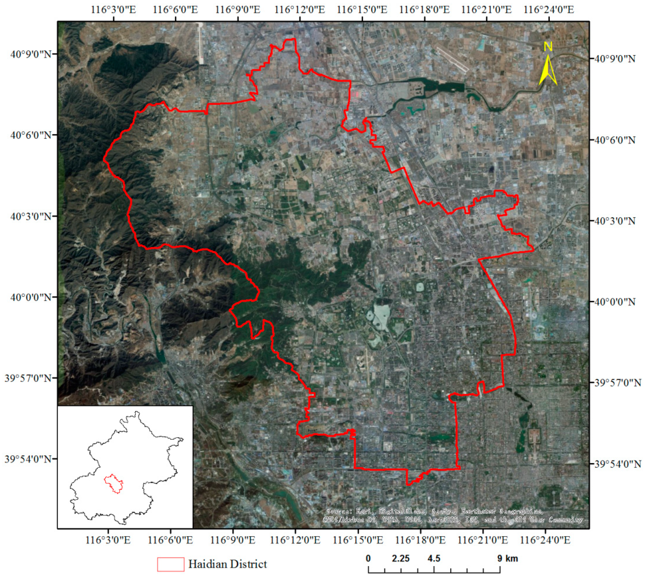
The Haidian District is located in the western and northwestern area of urban Beijing, China (Figure 1). It spans an area of 430.8 km2 and has a resident population of 3.6 million as of the end of 2016. Population density is higher in the southeast of the Haidian District [22]. There are various types of residential land, including single-family, multifamily, urban villages, and rural settlements. It is thus a difficult task to create a comfortable and livable residential environment for such an enormous population residing in different types of residential lands. Both the ecological comfortability and locational livability of the residential lands in the Haidian District have to be evaluated in order to support sustainable urban land use development.
2.2. Data Collection and Preprocessing
2.2.1. Remotely Sensed Images
In this study, four images captured by GaoFen-2 (GF-2) were collected to generate land use mapping and land cover mapping and then to calculate residential environmental factors. GaoFen-2 (GF-2) is a high-resolution satellite which was launched in 2014. It is able to collect images with a spatial resolution of 0.8 m for a panchromatic band and of 3.2 m for multi-spectral bands. The Panchromatic/Multi-Spectral sensor aboard GF-2 has five bands, namely, panchromatic, blue, green, red and near-infrared bands. GF-2 images were acquired on 12 September 2015 and were downloaded from China Center for Resources Satellite Data and Application (CRESDA), covering the study area of the Haidian District, Beijing, China.
Preprocessing of GF-2 images included radiometric, atmospheric correction, and geo-orthorectification. Radiometric calibration was applied to convert the raw digital number to top-of-atmosphere (TOA) reflectance using the parameters provided by CRESDA. Atmospheric correction was carried out to further convert the TOA reflectance to land surface reflectance using the fast line-of-sight atmospheric analysis of hypercubes (FLAASH) module in an ENVI environment. Geometric corrections were conducted using the Rational Polynomial Coefficients (RPC) orthorectification models. At last, the four GF-2 images were mosaicked to generate a mosaicked GF-2 image that can cover the whole the Haidian District.
2.2.2. Social Sensing Data
Residential land suitability analysis also involves two types of social sensing data, e.g., Tencent user density (TUD) and points-of-interests (POI) data.
The TUD data are derived from all Tencent platforms, such as Tencent Mobile App QQ, WeChat, Soso Maps, and other mobile applications that provide location-based services (LBS) using GPS devices [23]. The Tencent company records users’ locations when they use LBS apps and counts the number of users in each pixel unit, which results in the TUD data. The TUD data are shown at the publicly available Tencent website at a spatial resolution of 25 m, while every 25 m × 25 m pixel contains a number representing the number of users inside this area. The TUD data used in this paper is a composite product acquired from the Tencent company, with a temporal resolution of three hours. The mean TUD of the three time periods of 21:00 to 24:00, 0:00 to 3:00 and 3:00 to 6:00 on workdays were used to represent the population density within each residential land. Normally, people are at home at the above three time periods. Using the average value to describe the population of residential land is reliable. Previous studies show that the TUD data could accurately represent the daily activities of residents and map population distribution and can be well used in urban and transportation studies [23,24,25].
Baidu POI data within the Haidian District were acquired in 2016 via Baidu Maps Application Programming Interface (API). The POI data, including rich location semantic information [26], have been widely applied in order to understand urban environments from a human cognition perspective [27]. A POI is recorded with respect to three attributes: type, name, and geo-position (latitude, longitude). Specifically, POI types are automatically classified by Baidu Company. There are 17 level-1 categories, and each level-1 category is further divided into several level-2 categories. POI geo-position illustrates the location and distribution of city facilities. Therefore, POI data is a convenient and accurate data source to reflect the type, location and distribution of urban infrastructures. In this paper, the Baidu POI of shopping centers, parks, and medical services were used for the analysis of locational livability.
2.2.3. OpenStreetMap Road Network
OpenStreetMap (OSM), one of the biggest collaborative mapping projects, was also involved in getting living environmental information. OSM is freely accessible. Many researchers have applied road network data to urban land use mapping [27,28]. Both the completeness and the high positional accuracy of OSM have been confirmed [29,30]. Moreover, the data of road networks are in vector format and classify the streets into different levels based on their relative importance (http://wiki.openstreetmap.org/wiki/Key:highway). These characteristics make OSM a reliable data source. The OSM road network data were used in this paper for the calculation of distances from residential lands to urban amenities.
3. Methodology
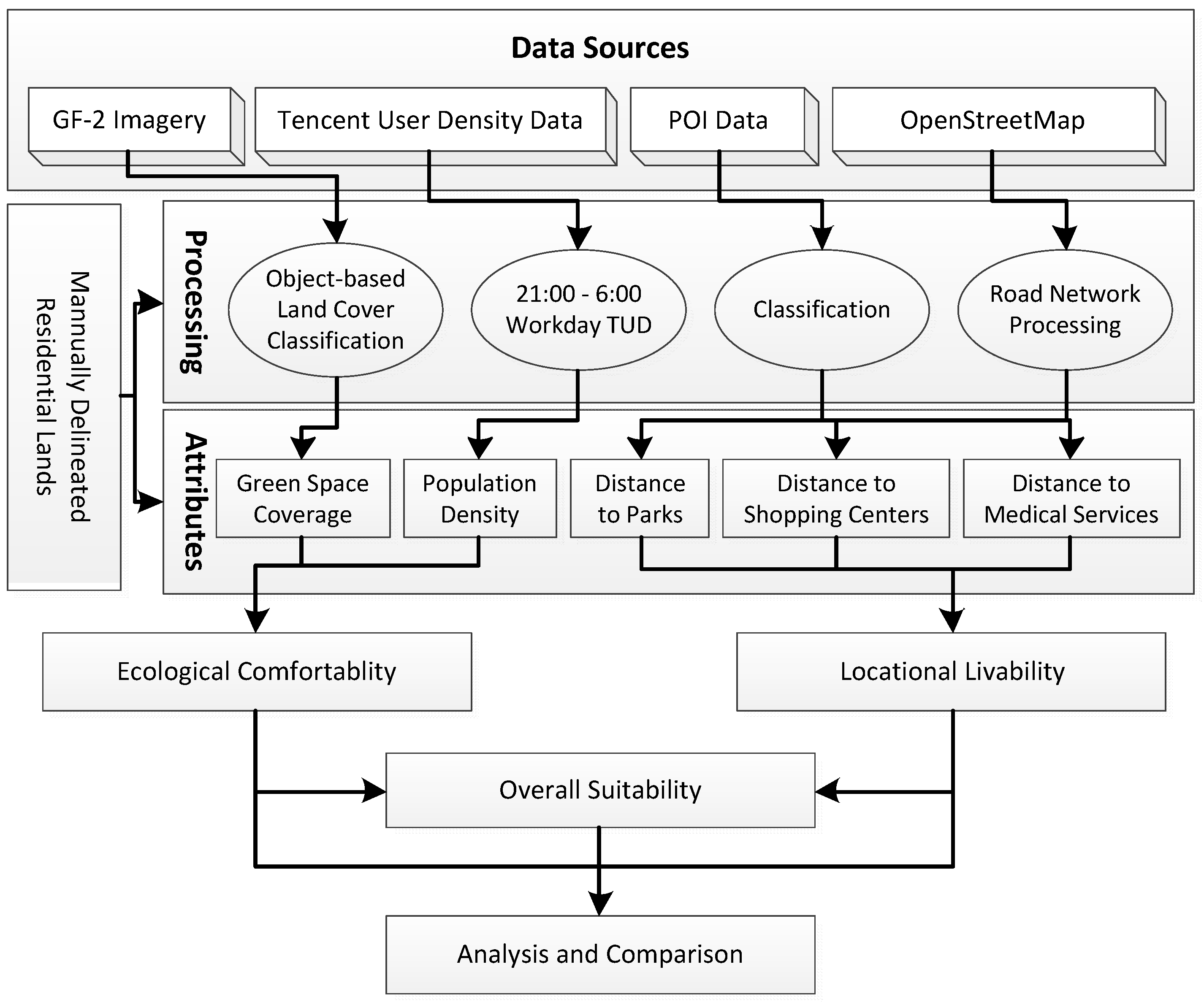
In this study, residential land suitability analysis was conducted through the framework of a three-stage procedure (Figure 2). First, land attributes used to depict residential land suitability were generated through image processing and spatial analysis; i.e., the four GF-2 images were used to extract green space through image classification within the Haidian District. Green space coverage was calculated through the area ratio statistic at a residential parcel scale. The TUD data were used to generate population density at the residential parcel scale. The POI data from Baidu Maps (http://map.baidu.com) were used to calculate the distance to parks, shopping centers and medical services together with road networks extracted from OSM data. Then, ecological comfortability and locational livability were evaluated using factor analysis. Ecological comfortability (EC) was assessed based on green space coverage (GSC) and population density (PD). Locational livability (LL) was evaluated using the distance to parks (PK), the distance to shopping centers (DS) and the distance to medical services (DM). At last, urban residential land suitability analysis was conducted through factor analysis based on the EC and LL evaluation results.
3.1. Urban Residential Lands Identification
The Chinese land use classification criterion (GB/T21010-2017) classifies built-up land into 8 classes: residential, institutional/public service, business, industrial, warehousing, transportation, public facilities, and open space. The residential class applies to both urban residential areas (houses and apartments) and rural settlements. According to the interpretation in “Chinese Current Land Use Classification” (GB/T 21010-2017), as well as the definition in urban planning regulations, urban residential land mainly refers to the human settlements’ land in cities, namely, the residential building base area and the reasonable space within the surrounding area, including the green space between the building and the road, etc.
In this study, urban residential parcels were defined to be the basic units for the urban residential land suitability analysis. Residential lands in the Haidian District were manually delineated by experienced analysts, with the assist of high-resolution remote sensing images, Baidu Maps (http://maps.baidu.com), Gaode Maps (https://ditu.amap.com/) and on-site surveys. The residential parcels can be identified with both the user’s and producer’s accuracy above 90%.
3.2. Residential Lands Attributes Quantification
For the residential suitability analysis, five attributes were calculated in this study, including green space coverage, population density, and distances to parks, shopping centers and medical services.
3.2.1. Green Space Coverage
Residential land suitability analysis should consider the ecological quality or comfortability of the area. The ecological attributes should be considered first. Remotely sensed images have been widely used to extract regional and local ecological parameters, such as leaf area index (LAI), net primary productivity (NPP), and green space coverage.
High green space coverage within residential areas is beneficial for the mental and physical health of residents. As a function of environment services, urban green space can preserve and enhance biodiversity [31], reduce noise [32], decrease air pollution [33], filter rainwater [34] and counteract high air temperatures with their cooling capabilities [35]. As a function of social services, urban green space can reduce stress [36], provide a sense of safety [37], strengthen interactions between residents [38] and promote the development of social ties [39]. Therefore, many countries and regions have explicit laws or regulations putting restrictions on the lowest green space coverage allowed within a residential land. For example, urban green space regulations for many cities in China require a minimum green space coverage of 30%. In this paper, the green space coverage was defined as the percentage of vegetation and water within a residential area, and it was derived from the classified GF-2 remotely sensed image. The green space coverage () can be expressed as Equation (1).
where , and are respectively the area of vegetation parcels, water parcels, and the residential land.
Vegetation parcels and water parcels were generated with an object-based classification method. This method was applied to the GF-2 image to classify the study area as impervious surface, vegetation, water or barren soil. Object-oriented image classification mainly involved three steps, i.e., multi-scale segmentation, general classes creation, and classification rules [40]. For image segmentation, GF-2 images were divided into segments (i.e., objects), and image segments were defined and calculated. Parameters are defined by users, including the scale, spectral properties and shape properties. These image segments have to be calculated on several hierarchical levels in a “trial and error” process to result in final image segments to represent single objects of interest [41].
Fifty sample areas (100 m × 100 m) were randomly selected to assess the classification accuracy, and land cover types of pixels within these sample areas were identified via visual interpretation by experienced analysts. The interpreted land covers the types of these pixels that were used as a reference for accuracy assessment. The results show that the overall accuracy reached 84.1%. Vegetation and water were extracted for the green space coverage calculation.
3.2.2. Population Density
Population density is directly associated with the comfortability of living [42]. Several studies have cited the negative psychological or pathological effects of housing crowding for adults, including psychological withdrawal [43], stress [44], aggression [45], and loneliness [46]. Other studies have also found more negative parent-child relations [47], less responsive parenting [46], and increased child behavioral problems at school [48]. Therefore, the population density of residential areas is an important factor in urban residential land suitability analysis. Residents were expected to be at home from 21:00 to 6:00 the next day. The density of user-reported locations within this period was considered to be able to represent population density within residential areas. Every 25 m × 25 m pixel contains a number representing the mean values of locating densities. Accordingly, the TUD of three time periods of 21:00 to 24:00, 0:00 to 3:00 and 3:00 to 6:00 on workdays were averaged to indicate population density within each residential area. The population density () can be expressed as Equation (2).
where , and are the mean values of locating densities within 25 m × 25 m pixel of three time periods on workdays, respectively.
3.2.3. Distances to Parks, Shopping Centers and Medical Services
If a residential land is close to urban amenities, it is regarded as more convenient for people to live in. Many studies have demonstrated that access to urban amenities is one of the most important factors when people choose places to live; therefore, residential lands closer to urban amenities are generally more valuable [49]. The location and type of urban amenities are parts of Baidu Maps POI information, so it is easy to extract them from categories of POI. Consequently, three types of urban amenities, including parks, shopping centers and medical services, were considered in this paper to quantitatively evaluate the locational livability of residential areas. To correctly derive the three attributes, Baidu Maps POI of the three types of urban amenities and OpenStreetMap road network were used. Distances of each residential area to the closest shopping center, park, and medical service along the road network were calculated, respectively. In this study, the shortest path solution is based on the Floyd algorithm. The Floyd algorithm is the most important algorithm in solving the shortest route problem in networks. It uses a route length matrix and a footpath matrix to obtain the solution of the shortest route between any pair of points by a method of iteration [50].
3.3. Multi-Criteria Evaluation
A legitimate evaluation of residential lands needs to take into consideration a suite of their attributes, such as population density, green space coverage, and distances to urban amenities as listed above. Currently, various MCE methods have been developed, including the analytical hierarchy process (AHP), factor analysis (FA), a technique for order of preference by similarity to an ideal solution (TOPSIS), data envelope analysis (DEA), and a knowledge-based system [51]. Of these, factor analysis is one of the most widely applied MCE methods. It can confirm the weight of each attribute and avoid the subjectivity associated with some other MCE methods such as AHP [51]. Factor analysis is a statistical method used to reduce many attributes into a few factors. In this study, the five attributes of residential areas were classified into two categories to describe the ecological comfortability (Equation (3)) and locational livability (Equation (4)), respectively. In addition, all five attributes were considered simultaneously to evaluate the overall suitability of residential lands (Equation (5)).
where EC, LL, and OS represent ecological comfortability, locational livability, and overall suitability of residential lands. PD, GSC, DS, DP, and DM are the five attributes of population density, green space coverage, distance to shopping centers, distance to parks, and distance to medical services, represents loadings of attributes on factors, and is the error term. Bartlett’s weighted least-squares method [52] was used to generate factor loadings and calculate factor scores EC, LL and OS. The Bartlett’s method is similar to the ordinary least squares (OLS) method which estimates factors scores by minimizing the sum of squared residuals, except that the squared residuals are weighted by the reciprocals of the specific variances. As compared with the OLS method, the factor score estimated by Bartlett’s method is an unbiased estimate of the true score.
4. Results and Analysis
4.1. Residential Areas of Haidian District
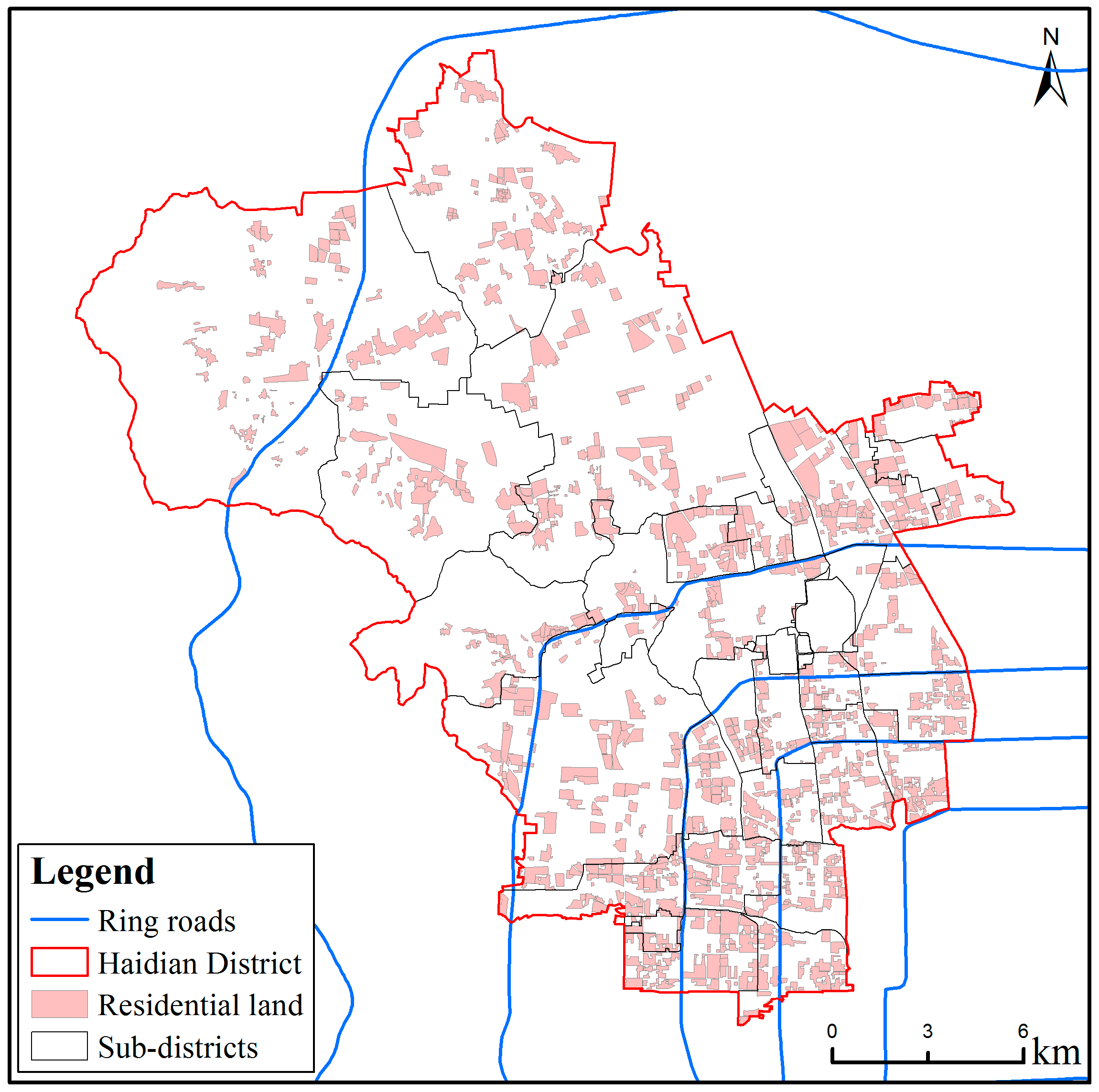
Residential areas extracted from GF-2 MS images through individual interpretation mainly include 1008 residential land parcels (Figure 3). The blue lines in Figure 3 from southeast to northwest represent the 2nd to the 6th ring roads in Beijing. Most urban areas in the Haidian District can be found located within the 5th ring road with an extra-urban area located just the north of the 5th ring road. High-density residential lands are focused in the southeastern Haidian District. Rural settlements are mostly dispersed outside the 5th ring roads.
4.2. Correlation among Attributes
Correlations among the five attributes were examined before factor analysis was conducted. Table 1 exhibited the pair-wise correlation coefficients between each two attributes. Most pair-wise correlations are moderate, ranging from 0.3 to 0.6. GSC is only weakly negatively correlated with DP, and not correlated with other attributes. DM and DS are strongly correlated with a correlation coefficient of 0.799.
4.3. Ecological Comfortability
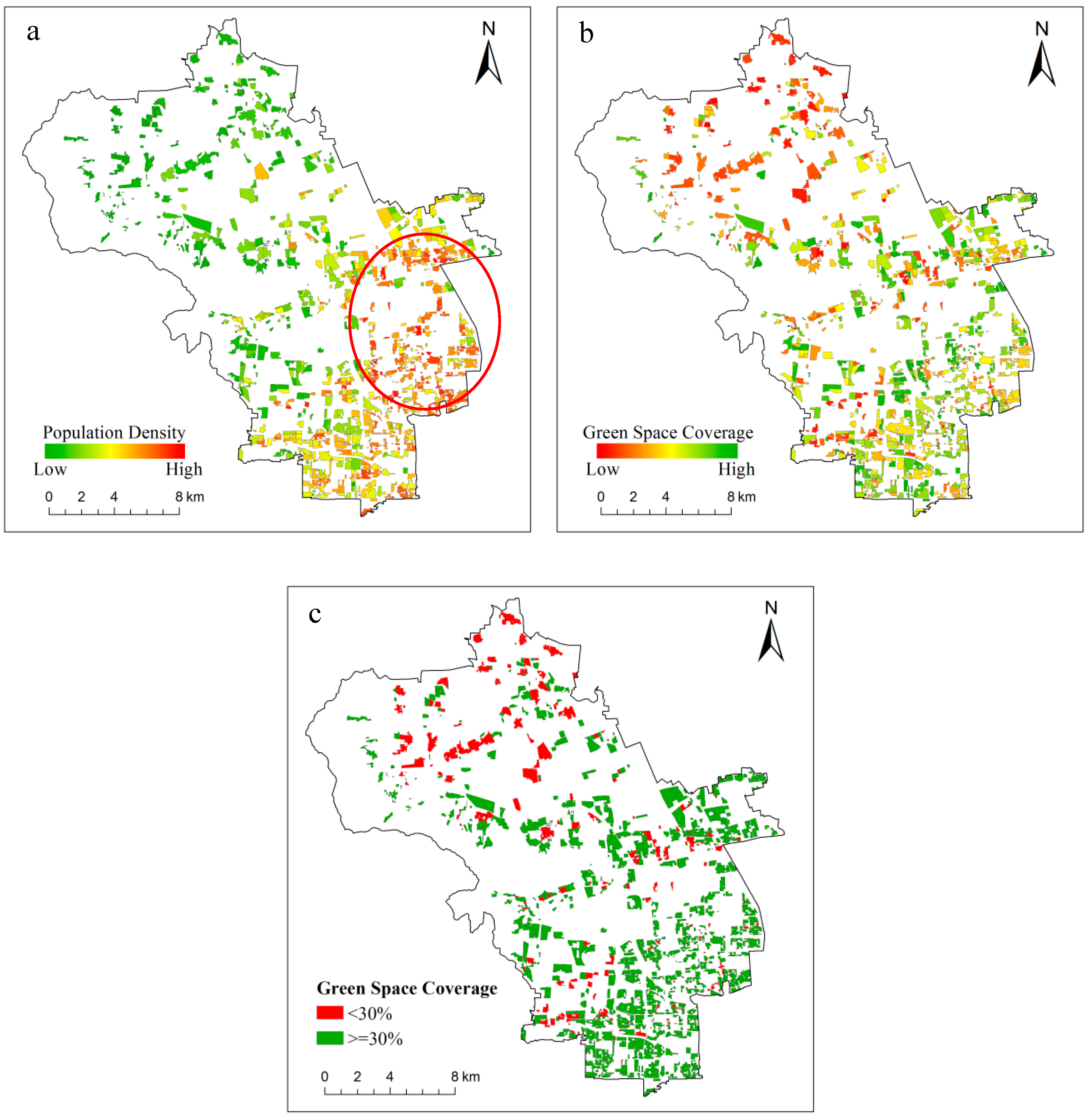
Ecological comfortability evaluation mainly concerns two attributes of residential land, i.e., population density and green space coverage. Figure 4 exhibits the spatial distribution of the two attributes.
The spatial distribution of population density (Figure 4a) exhibits an obvious gradient variation, and it decreases from southeast to northwest. The population density between the north 2nd and 3rd ring roads and around Zhongguancun subdistrict (red circle in Figure 4a) is the highest. The green space coverage (Figure 4b) also exhibits a pattern of higher coverage in the southeast and lower coverage in the northwest. To be specific, the highest coverage is situated between the 3rd and 4th ring roads, while the lowest GSC is located between the 5th and 6th ones. According to the requirement of a minimum GSC of 30% in the greening regulations for Beijing, residential lands were then separated with a threshold of GSC 30% (Figure 4c). Two hundred and twenty-seven out of 1008 residential lands had a green space coverage of less than 30%. Most of these residential lands were rural settlements in the north, and a few of them were urban gated communities sparsely distributed throughout the center and southwest. Shangzhuang subdistrict is the only one among all subdistricts that has an average green space coverage of less than 30%. All subdistricts within the 5th ring roads comply with the greening regulations, with the lowest Tiancunlu subdistrict having a mean green space coverage of 34.6%. Outside the 5th ring roads, most of the residential lands that do not comply with the regulations were distributed throughout the subdistricts of Sijiqing, Tiancunlu, and Qinglongqiao subdistricts.
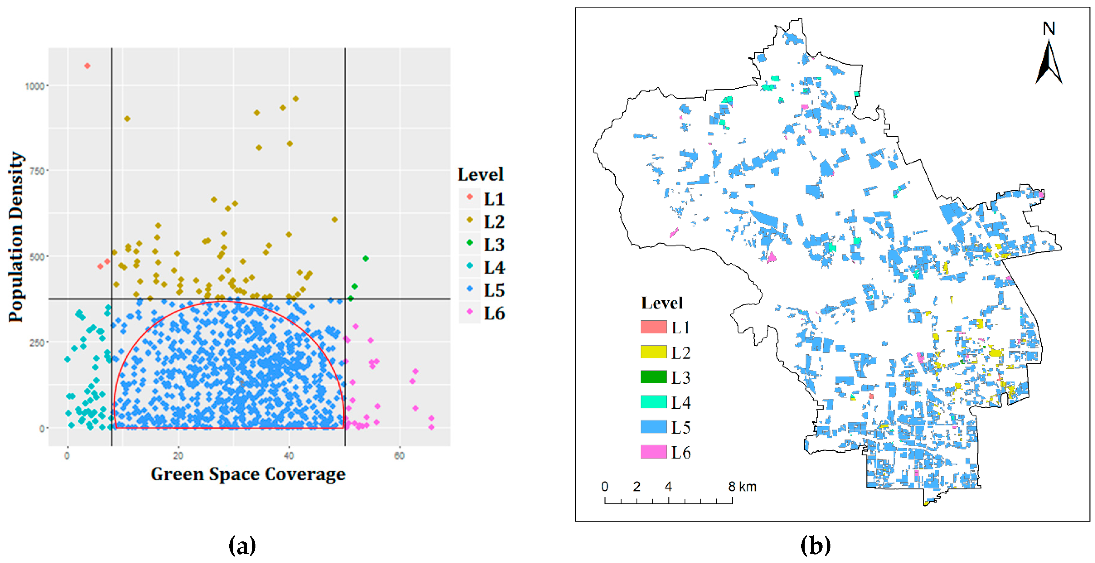
Analysis from the feature space of GSC and PD reveals that most of the residential areas are concentrated within a semicircle area (Figure 5a). Three tangents of this semicircle segment the data space into 6 regions, corresponding with 6 levels of ecological comfortability. The spatial distribution of the 6 levels is illustrated in Figure 5b.
- (1)
- Level 1: high population density with low green space coverage. Level 1 is the worst ecological comfortability level. There were only three residential lands of this level, all located in the southeastern area.
- (2)
- Level 2: high population density with moderate green space coverage. Residential lands of this mode were sparsely located in the east.
- (3)
- Level 3: high population density with high green space coverage.
- (4)
- Level 4: low population density with low green space coverage. Level 4 residential lands were distributed in the north and center of the study area.
- (5)
- Level 5: low population density with moderate green space coverage. This is the ecological comfortability level of most residential lands in the Haidian District.
- (6)
- Level 6: low population density with high green space coverage. Level 6 is the optimal ecological comfortability level. There were no concentrations of Level 6 residential lands. Rather, they were distributed all over the study area.
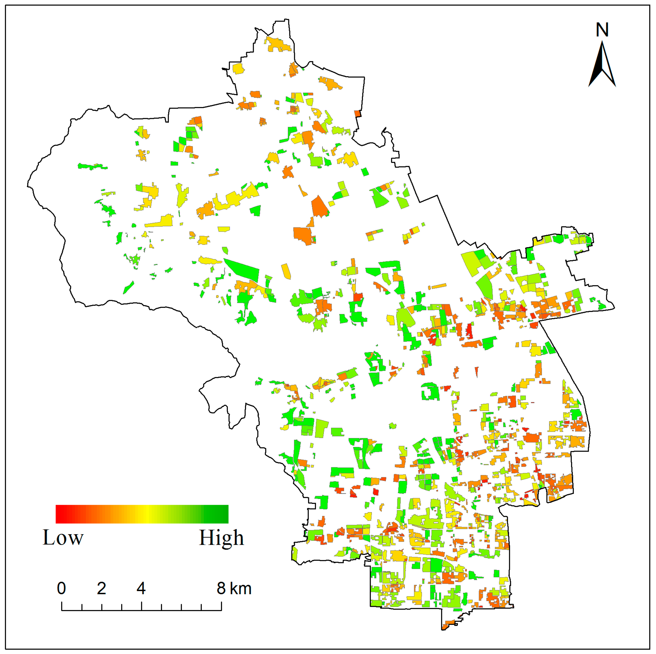
Multicriteria evaluation was conducted by parcels. PD and GSC were adopted to derive the ecological comfortability score using factor analysis (Figure 6). The ecological comfortability scores of residential lands were further averaged at a subdistrict level. About half of the residential lands have good ecological comfortability, yet their variations are great among subdistricts. Residential lands with lower ecological comfortability scores were mostly located in the subdistricts of Malianwa, Beixiaguan, and Haidian. The midwest and northwest of the study area consist of residential areas with higher ecological comfortability. The ecological comfortability score increases from the 2nd to the 6th ring roads. This is because, during the process of urban expansion, land parcels away from the city center generally have lower prices and more spacious areas, leading to a potentially higher proportion of green space. On the other hand, residential lands close to the city center face the issue of compact land use, resulting in an uncoordinated proportion of impervious surface to green space. The dense population within those residential lands further deteriorates the ecological comfortability.
4.4. Locational Livability
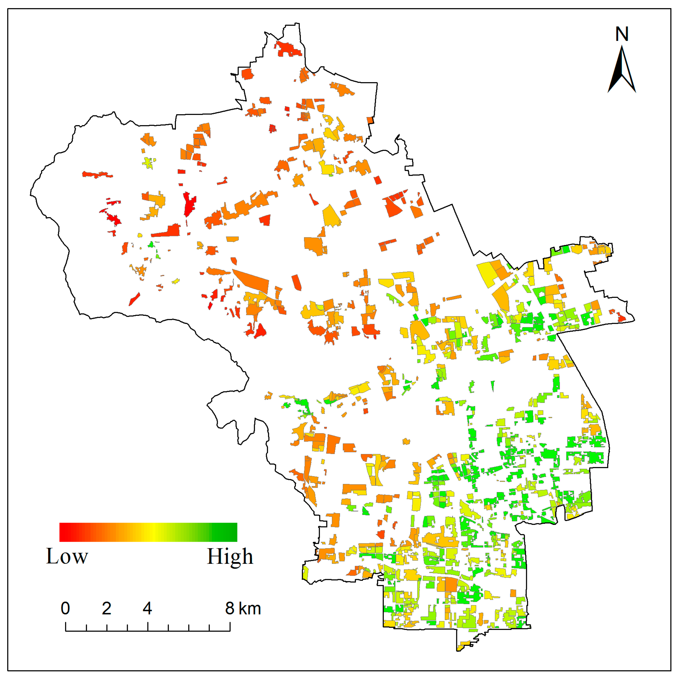
Unlike the ecological comfortability of the study area, the spatial distribution of locational livability took on a much more obvious gradient, with residential lands in the northwest having lower locational livability scores and the ones in the southeast having higher scores (Figure 7). This distribution pattern is closely associated with the urbanization process, in which early urbanized areas tended to have more completed settings of business, entertainment, culture, and transportation amenities. The less advanced development of residential amenities in the suburban and rural areas can have a highly negative impact on residents’ living convenience. The summarized results by subdistricts reveal that the subdistricts of Shangdi, Haidian, and Shuangyushu have the highest locational suitability. That is, residential lands within these subdistricts generally have easier access to residential amenities for recreation, shopping and health. On the other hand, subdistricts of Sujiatuo, Shangzhuang and Xiangshan have the lowest locational livability scores.
4.5. Residential Land Suitability Evaluation
The evaluation of the overall suitability of residential lands considers simultaneously all five attributes listed in Section 3.2. According to Bartlett’s method, the overall suitability is calculated as:
where OS represents the overall suitability of residential lands. PD, GSC, DS, DP, and DM are the five attributes of population density, green space coverage, distance to shopping centers, distance to parks, and distance to medical services.
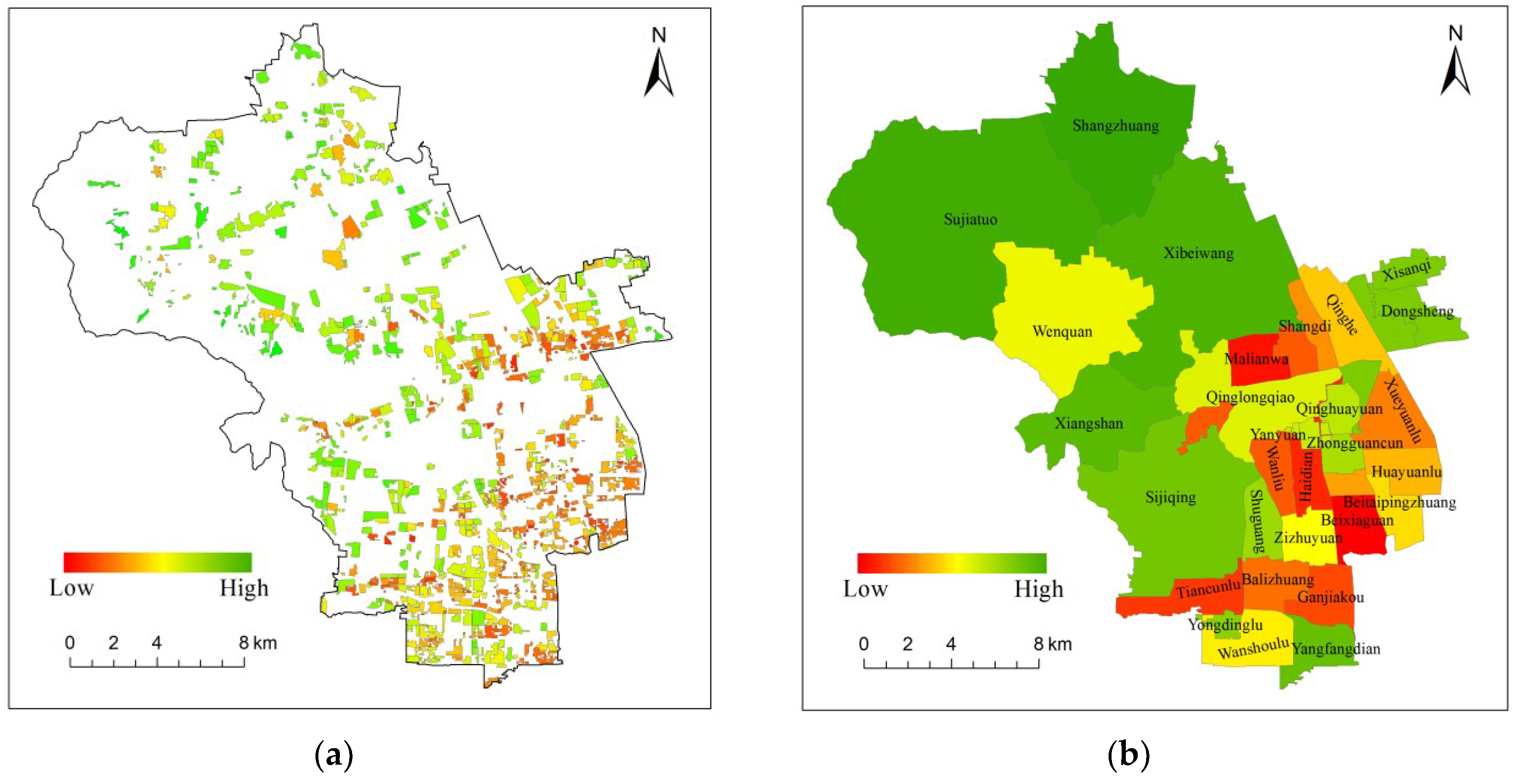
The evaluation results are shown in Figure 8. The overall suitability increases from southeast to northwest, which is consistent with the spatial variation of ecological comfortability and opposite to locational livability. This indicates that the variation of ecological comfortability between urban and suburban/rural areas is much larger than that of locational livability, causing the more consistent spatial distribution of overall suitability and ecological comfortability.
5. Discussion
5.1. Roles of VHR Remote Sensing Images
VHR Remote sensing images have rapid mapping abilities and provide accurate locations and attributes, which is very important for residential land mapping and green space coverage calculations. In this study, green space coverage was defined as the percentage of vegetation and water within a residential area, as derived from a GF-2 remotely sensed image with an object-based classification method. Residential lands were manually delineated by experienced analysts with high-resolution remote sensing images. This is the only part of the methodological framework which requires extensive human intervention. However, many studies have demonstrated the possibility of the automatic extraction of residential areas by classifying road-segmented land parcels [27,53].
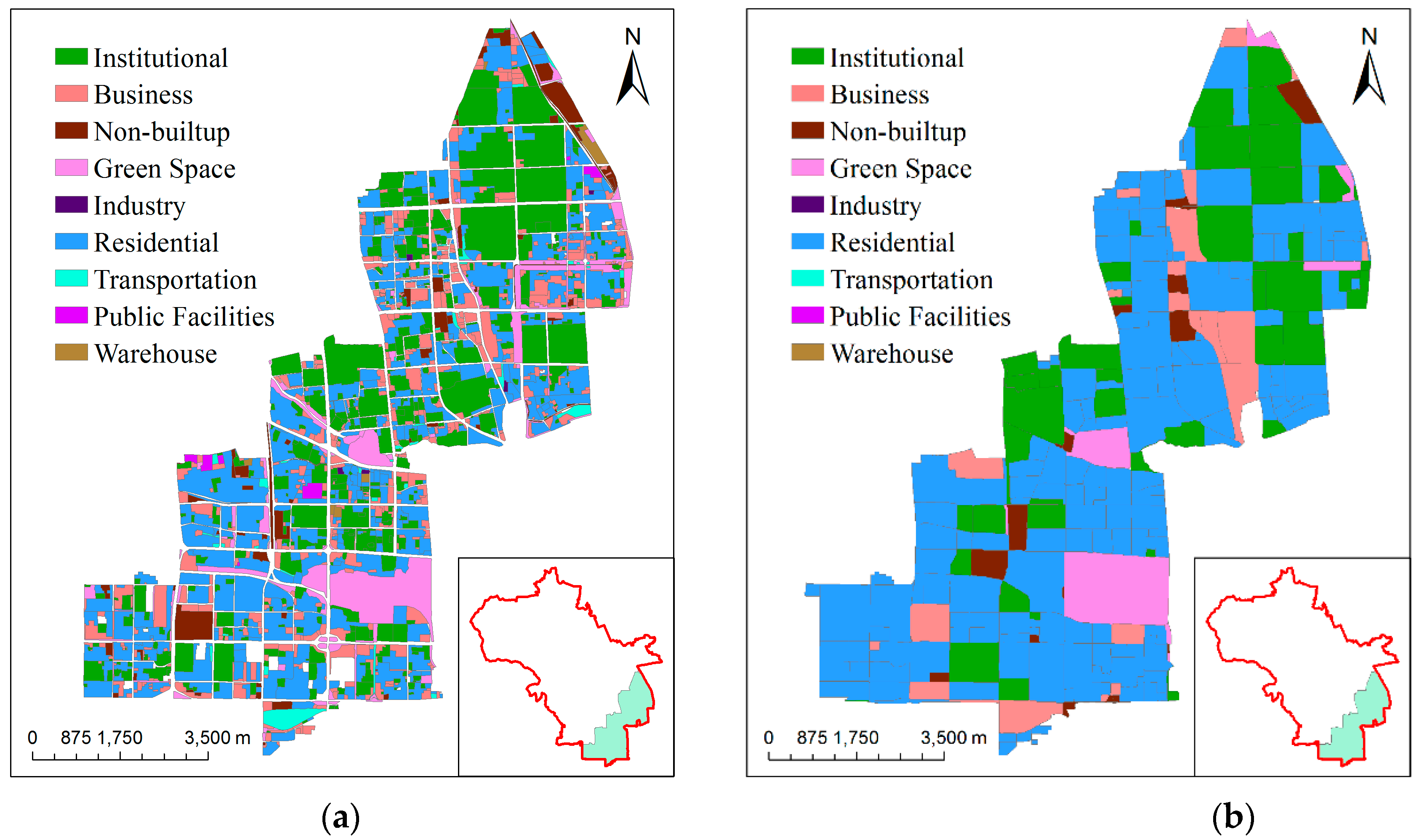
We tested a per-field classification approach combined with remote sensing and social sensing data, which was proposed to automatically map urban land use in great detail within a study area in the Haidian District, Beijing, China, in 2016. The results showed that the classification accuracy of residential parcels can achieve at 80%. It can be noted that this automatic method has lower accuracy than the manual classification method we used in this paper. Figure 9 displays the difference of land use classification generated from the manual method (a) and the automatic method (b) with a test area in the Haidian District. The residential parcels are illustrated in blue.
The automatic method used road segmentation to generate parcels; over-segmentation and under-segmentation were bound to impede the land use from being correctly classified. Otherwise, there are no clear boundaries between several different types of land use, so continuous patches are agglomerated to form mixed parcels. In this case, mixed parcels are easily classified into one type of land use classes. Because of the issues of the road networks’ quality and the mixed social functional parcels, the automatic results were less accurate than the manual ones. Therefore, if the road networks in the study area have high reliability, or it was less difficult to distinguish the boundaries between the different social functional types in remote sensing images, land use could be classified more accurately with an automatic classification method. Therefore, this methodological framework has the potential for automation realization.
5.2. Advantages of Incorporating Socially Sensed Data
Socially sensed data are abundant, updated, and can reflect more objectively residential distribution, which provides detailed information about the geographical location of living service facilities and traffic conditions. Combining socially sensed data for residential land suitability analysis can better describe socioeconomic activities.
Natural urban land-use suitability analysis and socioeconomic urban land-use suitability analysis are two kinds of analytic perspective and play different but equally important roles in urban mapping and studies. Urban land use maps categorize places where people undertake different socioeconomic activities [54], therefore the socioeconomic activities of citizens should be considered in urban land use suitability analysis. Although remote sensing data that reflects natural characteristics of urban land has been applied in natural urban land-use suitability analysis [4], social sensing data that contains socioeconomic and demographic characteristics of urban land has not been added into urban land-use suitability analyses. This study perceives POI data and TUD data as important social sensing data sources to integrate socioeconomic characteristics into urban land-use suitability analyses. Social sensing data is a particularly promising data resource and has two features: first, they can capture socioeconomic features well; second, the sensors for these data are individuals [21]. Compared with an exclusive analysis of remote sensing data, the additional social sensing data can help us to better understand interactions between citizens and land use objects and better assist urban planning.
5.3. Applicability of Methodology
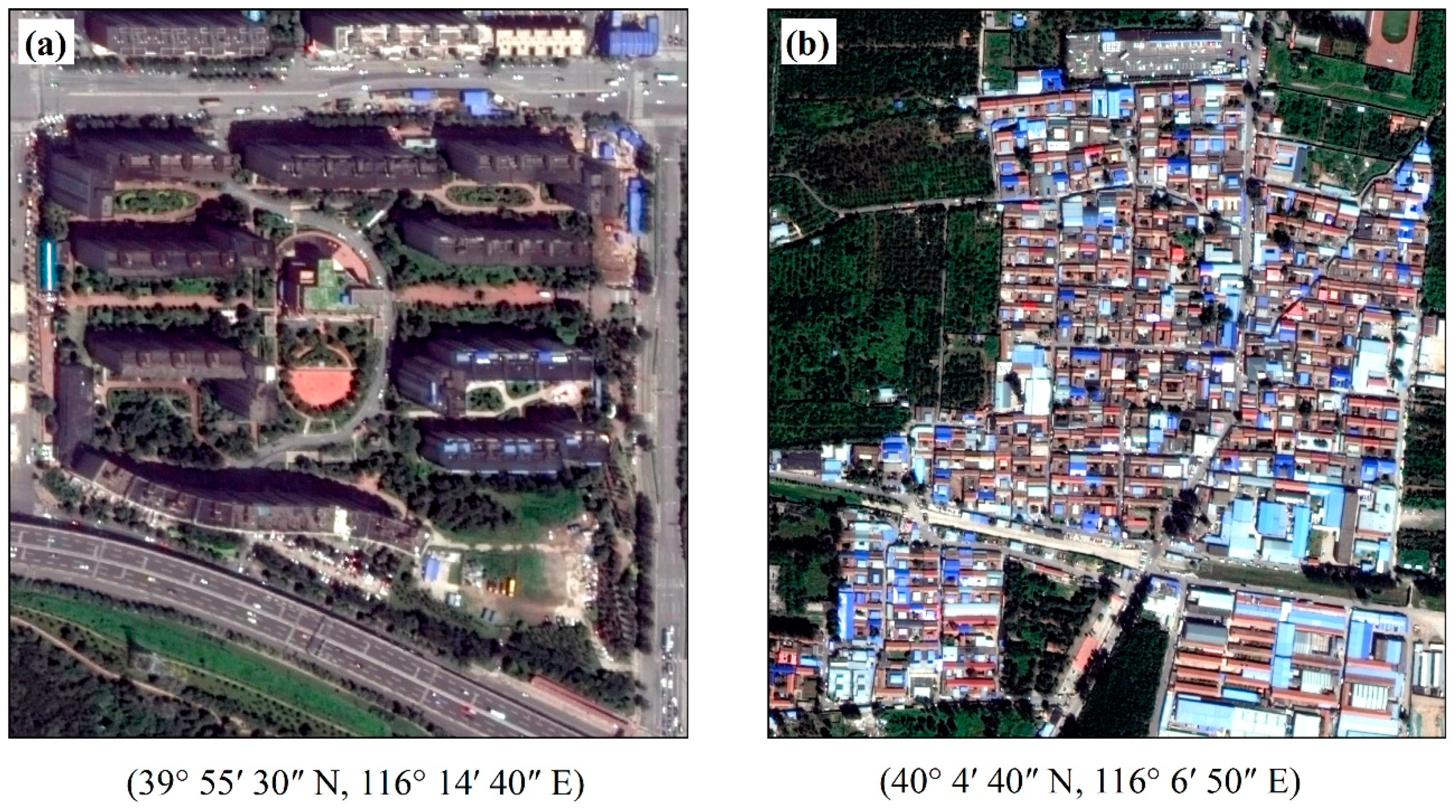
The evaluation framework proposed in this paper is more suitable for describing urban gated communities. A different framework is greatly needed for the suitability evaluation of rural settlements. The study area of the Haidian District is located in a transition area of urbanization, therefore the residential areas include both urban gated communities and rural settlements. Urban gated communities (xiaoqu in Chinese) are concentrated within the 5th ring road and are the basic structural unit of urban residential district planning (an example shown in Figure 10a) [55]. Urban gated communities are usually associated with a high quality of life and good services, such as convenient public facilities and public transit [54]. Either urban gated communities were selected to be built on a site close to residential amenities, or residential amenities will gradually develop alongside the community construction or occupancy. Buildings within these communities are usually high-rise, resulting in high-density living. Rural settlements (an example shown in Figure 10b), on the other hand, have totally different characteristics. They are mostly located in the northwestern Haidian District, composed of many one- or two-level single-family homes, leading to relatively lower population density. These rural settlements are surrounded by farmland or natural vegetation, reducing the residents’ demand for green space within the rural settlements. Residential amenities common in urban areas are rare around rural settlements. Therefore, strictly speaking, it is controversial to apply the same evaluation framework on both urban gated communities and rural settlements.
5.4. Implications of an Automatic and Fine-grained Urban Land-use Suitability Analysis
Based on remote sensing and social sensing data, which are easy to update with time, more rapid, reliable evaluation and analysis results can be provided for urban planning. With the more accurate road network data, residential lands can be delineated automatically in a timely and accurate manner; the methodological framework of residential land suitability evaluation proposed in this paper can be made highly automated, enabling the routine update of evaluation results, in order to support sustainable urban planning and urban land use development. For example, according to the results of this evaluation, not only can urban planners optimize residential suitability via optimizing factors related to ecological comfortability and locational livability of residential lands, but they can also quickly simulate the impacts of changing these factors. Therefore, an automatic framework for evaluating the suitability of urban residential areas plays a significant role in improving urban residential settlement environment.
In this paper, we used GF-2 remote sensing data with high resolution to generate highly detailed images of urban residential lands. The land-use suitability analysis based on parcels with a higher classification accuracy can provide urban planners with a detailed suitability map and assist them in conducting scientific urban planning. Urban land-use suitability is a framework for assessing the suitability of urban land that acknowledges and accounts for the connections between land use and economic, environmental, social and cultural impacts [56]. By providing urban researchers with information that highlights the interconnected and cumulative nature of urban land use impacts, urban land use suitability can assist urban researchers in understanding the implications of urban land uses for the full range of desired outcomes. Recently, more and more researchers fused high-resolution remote sensing images and multisource social sensing data to map fine-grained urban land use [23,27,28], which provides an opportunity to conduct fine-grained urban land use suitability analysis. Therefore, based on fine-grained urban land use map, fine-grained urban land-use suitability analysis is a trend. For example, Javadian, Shamskooshki and Momeni [15] established an automatic educational land use suitability analysis system to decide the location of environmentally suitable educational land use by AHP and GIS, which can cope with educational land use problems such as unsuitable site selection and imbalanced distribution of places that gets in the way of sustainable urban development.
5.5. Future Work
In this paper, five attributes were considered to evaluate the urban residential land suitability of the case study area. Actually, the urban residential land suitability is influenced by more than these attributes. Other attributes, such as heat and humidity that affect human comfort, various vegetation types that have different physical and social functions, and proximity to schools that were deemed important for a family with kids, were not considered in this paper due to either data unavailability or complexity in adopting the attribute. Consideration of more attributes in the future is expected to be able to generate more reasonable evaluation results.
Due to the limits of GF-2 remote sensing band designation, we consider less ecological comfortability attributes in this study. In the future, it is expected that the ecological indicators that are related to heat and humidity can be directly extracted from remote sensing data to create a more comprehensive ecological comfortability evaluation method.
On the other hand, vegetation types contribute differently to ecological quality. For example, in urban areas, trees provide shade on sunny days, and children enjoy playing in the grass. Based on the VHR remote sensing classification, green space can be identified with detailed information. For green space coverage and ecological comfortability analysis, it is necessary to consider trees, shrubs and grasslands.
Proximity to schools is one of the attributes of families with kids value when choosing a place to live in. However, due to various school systems across the world, it is difficult to include this attribute properly and quantitatively in a widely applicable evaluation framework. For example, the case study area of the Haidian District adopts the school district system, but the school quality within the same school district can differ greatly and entrance to a highly rated school is associated with certain randomness. Appropriate inclusion of school-related attributes in an urban residential land suitability evaluation framework is still challenging.
6. Conclusions
This paper proposed a new method for evaluating residential land suitability by combining remotely sensed ecological factors and socially sensed residential land attributes, and it then applied that method to a case study in the Haidian District of Beijing to analyze the suitability of residential areas. The following conclusions can be drawn from the study.
(1) Ecological comfortability evaluation based on remotely sensed green space coverage and TUD sourced population density could generate reliable results. Very-high-resolution (VHR) remotely sensed images could be used to generate exact geo-specific residential areas parcel by parcel. Green space extracted from VHR images could provide a reliable assessment of the ecological condition on a much finer scale. Population density calculated from the TUD data is more reliable than that derived from census data because it can provide more updated and more detailed information about residential distribution.
(2) Convenience evaluation of residential parcels based on socially sensed POI data proved to be feasible and scientific. VHR remote sensing images could give the exact location of every residential parcel, and POI data could provide the exact geo-location of supermarkets, parks, and hospitals. The distance to these daily living elements can be calculated for each residential land parcel. Thus, factor analysis using socially sensed data could generate a reliable evaluation of the convenience of residential areas.
(3) Residential land suitability evaluation using factor analysis in the Haidian District generated an overall residential land suitability map. The results show that the overall suitability increases from southeast to northwest, consistent with the spatial distribution of ecological comfortability, and the urban area tends to have lower ecological comfortability and higher locational livability compared to the suburban area in the northwest. Ground surveys confirmed that the results are reliable and convincing. Our method could potentially assist with the sustainable development of residential lands and urban land use planning. The combination of high-resolution remote sensing and social sensing data can provide urban planners with a comprehensive land suitability analysis and assist in more scientific urban planning. This method could result in the rapid, reliable, and fine-grained evaluation of residential land suitability and give assistance to city renewal and planning.
Author Contributions
Conceptualization, H.H. and Q.L.; methodology, Y.Z.; analysis, H.H. and Y.Z.; writing—original draft preparation, H.H.; writing—review and editing, Q.L. and Y.Z.; funding acquisition, H.H.
Funding
This study was funded by the National Key R&D Program of China (2017YFB0503800).
Conflicts of Interest
The authors declare no conflict of interest.
References
- Zellner, M.L.; Theis, T.L.; Karunanithi, A.T.; Garmestani, A.S.; Cabezas, H. A new framework for urban sustainability assessments: Linking complexity, information and policy. Comput. Environ. Urban Syst. 2008, 32, 474–488. [Google Scholar] [CrossRef] [Green Version]
- Mondal, B.; Das, D.N. How residential compactness and attractiveness can be shaped by environmental amenities in an industrial city? Sustain. Cities Soc. 2018, 41, 363–377. [Google Scholar] [CrossRef]
- Xu, Z.; Li, Q. Integrating the empirical models of benchmark land price and GIS technology for sustainability analysis of urban residential development. Habitat Int. 2014, 44, 79–92. [Google Scholar] [CrossRef]
- Luo, J.; Du, P.; Samat, A.; Feng, L. Evaluation on the natural suitability of urban human settlement environment using multisource data. Proceedings of Urban Remote Sensing Event, Lausanne, Switzerland, 30 March–1 April 2015; pp. 1–4. [Google Scholar]
- Collins, M.G.; Steiner, F.R.; Rushman, M.J. Land-Use Suitability Analysis in the United States: Historical Development and Promising Technological Achievements. Environ. Manag. 2001, 28, 611–621. [Google Scholar] [CrossRef]
- Yang, J.; Liu, Y.; Wang, S. An overview of the methods of GIS-based land-use suitability analysis. Proc. SPIE 2007, 6754, 675438. [Google Scholar]
- Malczewski, J. GIS-based land-use suitability analysis: A critical overview. Prog. Plan. 2004, 62, 3–65. [Google Scholar] [CrossRef]
- Bojórquez-Tapia, L.A.; Diaz-Mondragón, S.; Ezcurra, E. GIS-based approach for participatory decision making and land suitability assessment. Int. J. Geogr. Inf. Syst. 2001, 15, 129–151. [Google Scholar] [CrossRef]
- Santanu Kumar Misra, S.S. Site Suitability Analysis for Urban Development: A Review. Int. J. Recent Innov. Trends Comput. Commun. 2015, 3, 3647–3651. [Google Scholar]
- Liaghat, M.; Shahabi, H.; Deilami, B.R.; Ardabili, F.S.; Seyedi, S.N.; Badri, H. A Multi-Criteria Evaluation Using the Analytic Hierarchy Process Technique to Analyze Coastal Tourism Sites. Apcbee Procedia 2013, 5, 479–485. [Google Scholar] [CrossRef]
- Moreno, D.; Seigel, M. A GIS approach for corridor siting and environmental impact analysis. In Proceedings of the GIS/LIS 1988 the Third Annual International Conference, Antonio, TX, USA, 30 November–2 December 1988; pp. 507–514. [Google Scholar]
- Siddiqui, M.Z.; Everett, J.W.; Vieux, B.E. Landfill Siting Using Geographic Information Systems: A Demonstration. J. Environ. Eng. 1996, 122, 515–523. [Google Scholar] [CrossRef]
- Hu, Y.-M.; Wu, H.-F.; Wu, Z.-F. GIS-Based soil quality evaluation with fuzzy variable weight. Acta Pedol. Sin. 2001, 38, 266–274. Available online: http://www.cnki.com.cn/Article/CJFDTotal-TRXB200103004.htm (accessed on 14 April 2019). (In Chinese).
- Kalogirou, S. Expert systems and GIS: An application of land suitability evaluation. Comput. Environ. Urban Syst. 2002, 26, 89–112. [Google Scholar] [CrossRef]
- Javadian, M.; Shamskooshki, H.; Momeni, M. Application of Sustainable Urban Development in Environmental Suitability Analysis of Educational Land Use by Using Ahp and Gis in Tehran. Procedia Eng. 2011, 21, 72–80. [Google Scholar] [CrossRef] [Green Version]
- Sun, J.; Liu, Z.; Wei, Y. Spatial Analysis and Present Situation Evaluation of Urban Residential Land Suitability Based on GIS: A Case Study in Changchun, China. In Proceedings of the International Conference on Management and Service Science, Wuhan, China, 20–22 September 2009; pp. 1–4. [Google Scholar]
- Fu, Y.; Zeng, G.M.; Du, C.Y.; Lin, T.; Zhou, J.F.; Li, Z.W. Integrated geographic information systems-based suitability evaluation of urban land expansion: A combination of analytic hierarchy process and grey relational analysis. Environ. Eng. Sci. 2009, 26, 1025–1032. [Google Scholar]
- Zhang, X.; Fang, C.; Wang, Z.; Ma, H. Urban construction land suitability evaluation based on improved multi-criteria evaluation based on GIS (MCE-GIS): Case of New Hefei City, China. Chin. Geogr. Sci. 2013, 23, 740–753. [Google Scholar] [CrossRef]
- Malczewski, J. Ordered weighted averaging with fuzzy quantifiers: GIS-based multicriteria evaluation for land-use suitability analysis. Int. J. Appl. Earth Obs. Geoinform. 2006, 8, 270–277. [Google Scholar] [CrossRef]
- Li, J.; Benediktsson, J.A.; Zhang, B.; Yang, T.; Plaza, A. Spatial Technology and Social Media in Remote Sensing: A Survey. Proc. IEEE 2017, PP, 1–10. [Google Scholar] [CrossRef]
- Liu, Y.; Liu, X.; Gao, S.; Gong, L.; Kang, C.; Zhi, Y.; Chi, G.; Shi, L. Social Sensing: A New Approach to Understanding Our Socioeconomic Environments. Ann. Assoc. Am. Geogr. 2015, 105, 512–530. [Google Scholar] [CrossRef]
- Roitman, L.A.; Zhang, Y.; Tan, Z.; He, C. Social Stratification and Residential Segregation in Haidian District, Beijing, China. Int. J. Econ. Manag. Sci. 2017, 6, 412. [Google Scholar] [CrossRef]
- Yao, Y.; Liu, X.; Li, X.; Zhang, J.; Liang, Z.; Mai, K.; Zhang, Y. Mapping fine-scale population distributions at the building level by integrating multisource geospatial big data. Int. J. Geogr. Inf. Sci. 2017, 31, 1220–1244. [Google Scholar] [CrossRef]
- Zhang, S.; Wu, Y.; Cai, X. WeChat traffic profile and impact on mobile networks. In Proceedings of the IEEE/CIC International Conference on Communications in China, Shanghai, China, 13–15 October 2014; pp. 334–338. [Google Scholar]
- Niu, N.; Liu, X.; Jin, H.; Ye, X.; Liu, Y.; Li, X.; Chen, Y.; Li, S. Integrating multi-source big data to infer building functions. Int. J. Geogr. Inf. Sci. 2017, 31, 1871–1890. [Google Scholar] [CrossRef]
- Yuan, N.J.; Zheng, Y.; Xie, X.; Wang, Y.; Zheng, K.; Xiong, H. Discovering Urban Functional Zones Using Latent Activity Trajectories. IEEE Trans. Knowl. Data Eng. 2015, 27, 712–725. [Google Scholar] [CrossRef]
- Zhang, Y.; Li, Q.; Huang, H.; Wu, W.; Du, X.; Wang, H. The Combined Use of Remote Sensing and Social Sensing Data in Fine-Grained Urban Land Use Mapping: A Case Study in Beijing, China. Remote Sens. 2017, 9, 865. [Google Scholar] [CrossRef]
- Hu, T.; Yang, J.; Li, X.; Gong, P. Mapping Urban Land Use by Using Landsat Images and Open Social Data. Remote Sens. 2016, 8, 151. [Google Scholar] [CrossRef]
- Haklay, M. How Good is Volunteered Geographical Information? A Comparative Study of OpenStreetMap and Ordnance Survey Datasets. Environ. Plan. B Plan. Des. 2016, 93, 3–11. [Google Scholar] [CrossRef]
- Wan, T.; Lu, H.; Lu, Q.; Luo, N. Classification of High-Resolution Remote-Sensing Image Using OpenStreetMap Information. IEEE Geosci. Remote Sens. Lett. 2017, 14, 2305–2309. [Google Scholar] [CrossRef]
- Tratalos, J.; Fuller, R.A.; Warren, P.H.; Davies, R.G.; Gaston, K.J. Urban form, biodiversity potential and ecosystem services. Landsc. Urban Plan. 2007, 83, 308–317. [Google Scholar] [CrossRef]
- Gidlöf-Gunnarsson, A.; Öhrström, E. Noise and well-being in urban residential environments: The potential role of perceived availability to nearby green areas. Landsc. Urban Plan. 2007, 83, 115–126. [Google Scholar] [CrossRef]
- Scott, K.I.; Mcpherson, E.G.; Simpson, J.R. Air pollutant uptake by Sacramento’s urban forest. J. Arboricult. 1998, 24, 224–233. Available online: https://www.researchgate.net/profile/Klaus_Scott/publication/265402520_Air_pollutant_uptake_by_Sacrameto%27s_urban_forest/links/5422fb640cf238c6ea6e2f01/Air-pollutant-uptake-by-Sacrametos-urban-forest.pdf (accessed on 14 April 2019).
- Zhang, B.; Xie, G.D.; Li, N.; Wang, S. Effect of urban green space changes on the role of rainwater runoff reduction in Beijing, China. Landsc. Urban Plan. 2015, 140, 8–16. [Google Scholar] [CrossRef] [Green Version]
- Bowler, D.E.; Buyung-Ali, L.; Knight, T.M.; Pullin, A.S. Urban greening to cool towns and cities: A systematic review of the empirical evidence. Landsc. Urban Plan. 2010, 97, 147–155. [Google Scholar] [CrossRef]
- Chiesura, A. The role of urban parks for the sustainable city. Landsc. Urban Plan. 2004, 68, 129–138. [Google Scholar] [CrossRef]
- Kuo, F.E. Transforming inner-city landscapes: Trees, sense of safety, and preference. Environ. Behav. 1998, 30, 28–59. [Google Scholar] [CrossRef]
- Martin, C.A.; Warren, P.S.; Kinzig, A.P. Neighborhood socioeconomic status is a useful predictor of perennial landscape vegetation in residential neighborhoods and embedded small parks of Phoenix, AZ. Landsc. Urban Plan. 2004, 69, 355–368. [Google Scholar] [CrossRef]
- Kuo, F.E.; Sullivan, W.C. Environment and Crime in the Inner City Does Vegetation Reduce Crime? Environ. Behav. 2001, 33, 343–367. [Google Scholar] [CrossRef]
- Parivallal, R.; Dhivya Bharathi, L.; Elang, K.; Karthik, T.; Nagarajan, B. An Approach to Classify the Object from the Satellite Image using Image Analysis Tool. Int. J. Innov. Res. Sci. Technol. 2004, 1, 83–87. [Google Scholar]
- Laliberte, A.S.; Rango, A.; Havstad, K.M.; Paris, J.F.; Beck, R.F.; McNeely, R.; Gonzalez, A.L. Object-oriented image analysis for mapping shrub encroachment from 1937 to 2003 in southern New Mexico. Remote Sens. Environ. 2004, 93, 198–210. [Google Scholar] [CrossRef]
- Calhoun, J.B. Population density and social pathology. Sci. Am. 1962, 206, 139–148. [Google Scholar] [PubMed]
- Regoeczi, W.C. Crowding in context: An examination of the differential responses of men and women to high-density living environments. J. Health Soc. Behav. 2008, 49, 254–268. [Google Scholar] [CrossRef]
- Valins, S.; Baum, A. Residential Group Size, Social Interaction, and Crowding. Environ. Behav. 1973, 5, 421–439. [Google Scholar] [CrossRef]
- Clark, W.A.V.; Deurloo, M.C.; Dieleman, F.M. Housing Consumption and Residential Crowding in U.S. Housing Markets. J. Urban Aff. 2010, 22, 49–63. [Google Scholar] [CrossRef]
- Wenz, F.V. Household Crowding, Loneliness and Suicide Ideation. Psychol. A Q. J. Hum. Behav. 1984, 21, 25–29. [Google Scholar]
- Evans, G.W.; Lepore, S.J.; Shejwal, B.R.; Palsane, M.N. Chronic Residential Crowding and Children’s Well-Being: An Ecological Perspective. Child Dev. 1998, 69, 1514–1523. [Google Scholar] [CrossRef] [PubMed]
- Evans, G.W.; Saltzman, H.; Cooperman, J.L. Housing Quality and Children’s Socioemotional Health. Environ. Behav. 2001, 33, 389–399. [Google Scholar] [CrossRef]
- Allen, N. Understanding the Importance of Urban Amenities: A Case Study from Auckland. Buildings 2015, 5, 85–99. [Google Scholar] [CrossRef]
- Floyd, R.W. Algorithm 97: Shortest path. Commun. ACM 1962, 5, 345. [Google Scholar] [CrossRef]
- Govindan, K.; Rajendran, S.; Sarkis, J.; Murugesan, P. Multi criteria decision making approaches for green supplier evaluation and selection: A literature review. J. Clean. Prod. 2015, 98, 66–83. [Google Scholar] [CrossRef]
- Bartlett, M.S. The statistical conception of mental factors. Br. J. Psychol. 1937, 28, 97–104. [Google Scholar] [CrossRef]
- Long, Y.; Liu, X. Automated identification and characterization of parcels (AICP) with OpenStreetMap and Points of Interest. Environ. Plan. B 2015, 43, 498–510. [Google Scholar]
- Zhao, P.; Zhang, M. Informal suburbanization in Beijing: An investigation of informal gated communities on the urban fringe. Habitat Int. 2018, 77, 130–142. [Google Scholar] [CrossRef]
- Wallenwein, F. The Housing Model xiaoqu: The Expression of an Increasing Polarization of the Urban Population in Chinese Cities? Master’s Thesis, Heidelberg University, Heidelberg, Germany, 2014. Available online: https://archiv.ub.uni-heidelberg.de/volltextserver/17143/ (accessed on 14 April 2019).
- Mcdowell, R.W.; Snelder, T.; Harris, S.; Lilburne, L.; Larned, S.T.; Scarsbrook, M.; Curtis, A.; Holgate, B.; Phillips, J.; Taylor, K. The land use suitability concept: Introduction and an application of the concept to inform sustainable productivity within environmental constraints. Ecol. Indic. 2018, 91, 212–219. [Google Scholar] [CrossRef]
Figure 1.
The study area of the Haidian District and the location of the Haidian District within Beijing, China.
Figure 1.
The study area of the Haidian District and the location of the Haidian District within Beijing, China.

Figure 2.
The methodological framework of urban residential land suitability analysis.

Figure 3.
Distribution of residential lands within the Haidian District.

Figure 4.
Population density (a), and green space coverage (b,c) of residential lands in the Haidian District.
Figure 4.
Population density (a), and green space coverage (b,c) of residential lands in the Haidian District.

Figure 5.
Six levels of ecological comfortability of residential lands in Haidian District: (a) scatter plots of green space coverage against population density; (b) spatial distribution of residential lands of the six levels.
Figure 5.
Six levels of ecological comfortability of residential lands in Haidian District: (a) scatter plots of green space coverage against population density; (b) spatial distribution of residential lands of the six levels.

Figure 6.
The ecological comfortability scores of residential lands.

Figure 7.
The locational livability scores of residential lands.

Figure 8.
The overall suitability scores of residential lands (a) and of subdistricts (b).

Figure 9.
The classification results in one part area in the Haidian District (a) and the manual results (b).
Figure 9.
The classification results in one part area in the Haidian District (a) and the manual results (b).

Figure 10.
Examples of an urban gated community (a) and a rural settlement (b) on remote sensing images.
Figure 10.
Examples of an urban gated community (a) and a rural settlement (b) on remote sensing images.


Table 1.
Correlation matrix of five attributes used to evaluate urban residential land suitability.
| PD | GSC | DP | DS | DM | |
|---|---|---|---|---|---|
| PD | 1 | −0.054 | −0.385 | −0.468 | −0.505 |
| GSC | −0.054 | 1 | −0.218 | 0.045 | −0.027 |
| DP | −0.385 | −0.218 | 1 | 0.324 | 0.399 |
| DS | −0.468 | 0.045 | 0.324 | 1 | 0.799 |
| DM | −0.505 | −0.027 | 0.399 | 0.799 | 1 |
© 2019 by the authors. Licensee MDPI, Basel, Switzerland. This article is an open access article distributed under the terms and conditions of the Creative Commons Attribution (CC BY) license (http://creativecommons.org/licenses/by/4.0/).
Share and Cite
MDPI and ACS Style
Huang, H.; Li, Q.; Zhang, Y. Urban Residential Land Suitability Analysis Combining Remote Sensing and Social Sensing Data: A Case Study in Beijing, China. Sustainability 2019, 11, 2255. https://0-doi-org.brum.beds.ac.uk/10.3390/su11082255
AMA Style
Huang H, Li Q, Zhang Y. Urban Residential Land Suitability Analysis Combining Remote Sensing and Social Sensing Data: A Case Study in Beijing, China. Sustainability. 2019; 11(8):2255. https://0-doi-org.brum.beds.ac.uk/10.3390/su11082255
Chicago/Turabian StyleHuang, Huiping, Qiangzi Li, and Yuan Zhang. 2019. "Urban Residential Land Suitability Analysis Combining Remote Sensing and Social Sensing Data: A Case Study in Beijing, China" Sustainability 11, no. 8: 2255. https://0-doi-org.brum.beds.ac.uk/10.3390/su11082255
Note that from the first issue of 2016, this journal uses article numbers instead of page numbers. See further details here.