Smart City Governance and Children’s Agency: An Assessment of the Green Infrastructure Impact on Children’s Activities in Cagliari (Italy) with the Tool “Opportunities for Children in Urban Spaces (OCUS)”


Abstract
:1. Introduction
2. Materials and Methods
2.1. Urban Blue–Green Infrastructures
2.2. Concepts for Assessing Urban BGI Components
2.3. Review of Methodological Approaches
3. Methodology
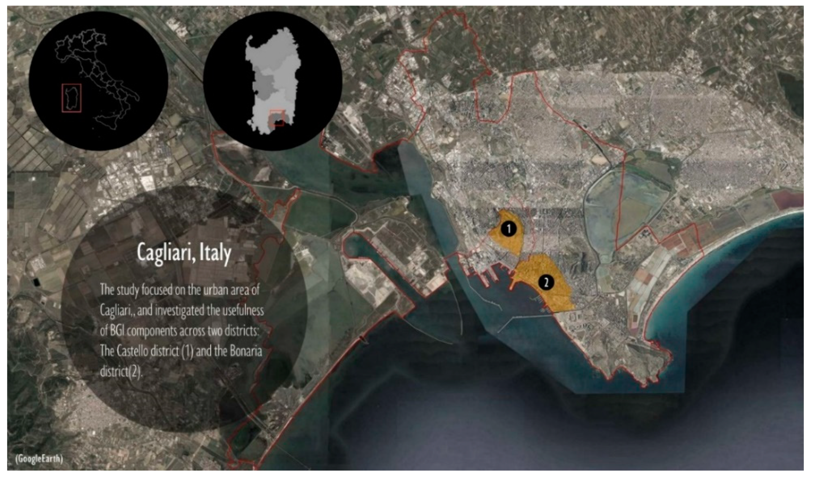
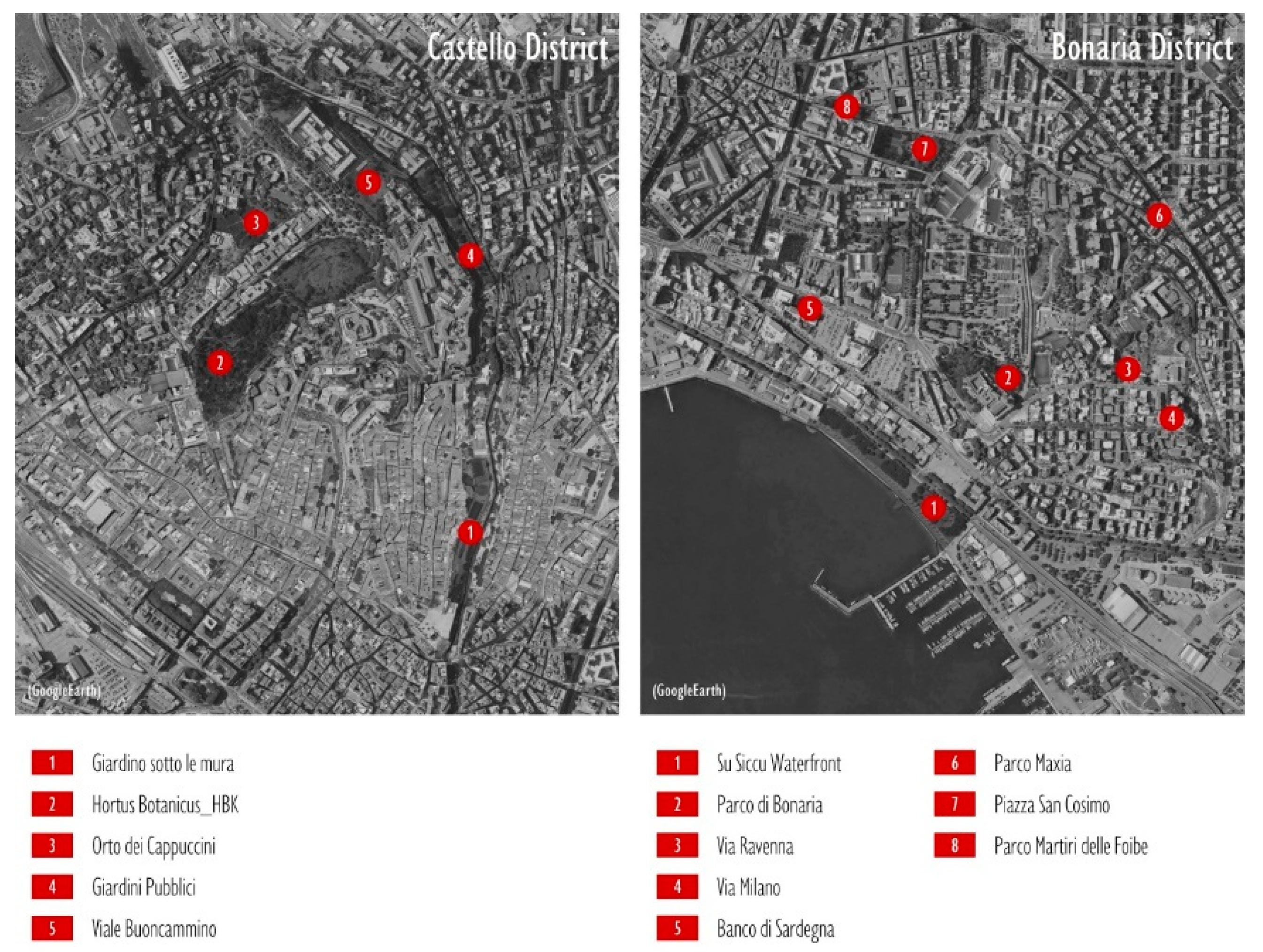
4. Selection of the Case Study
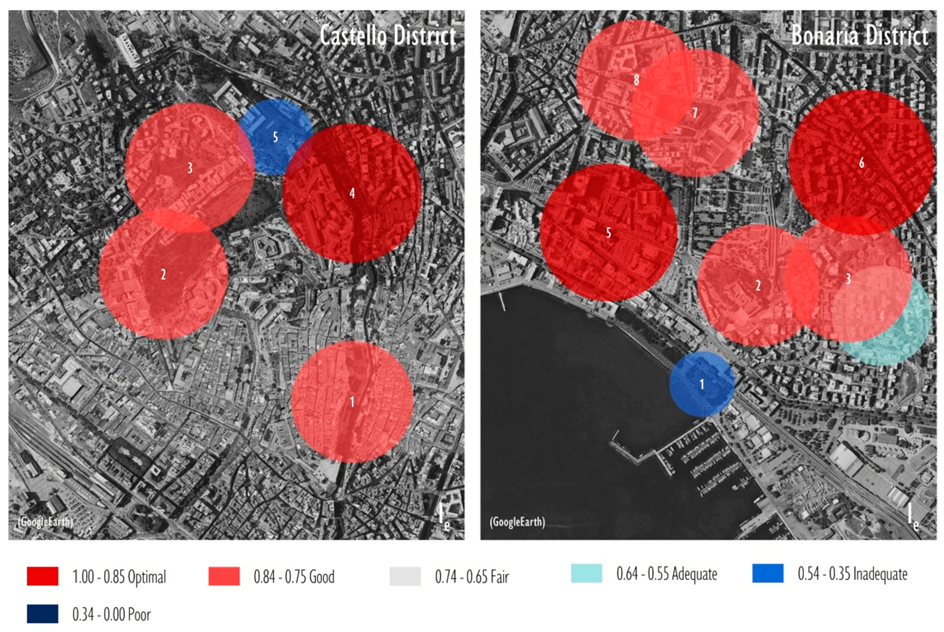
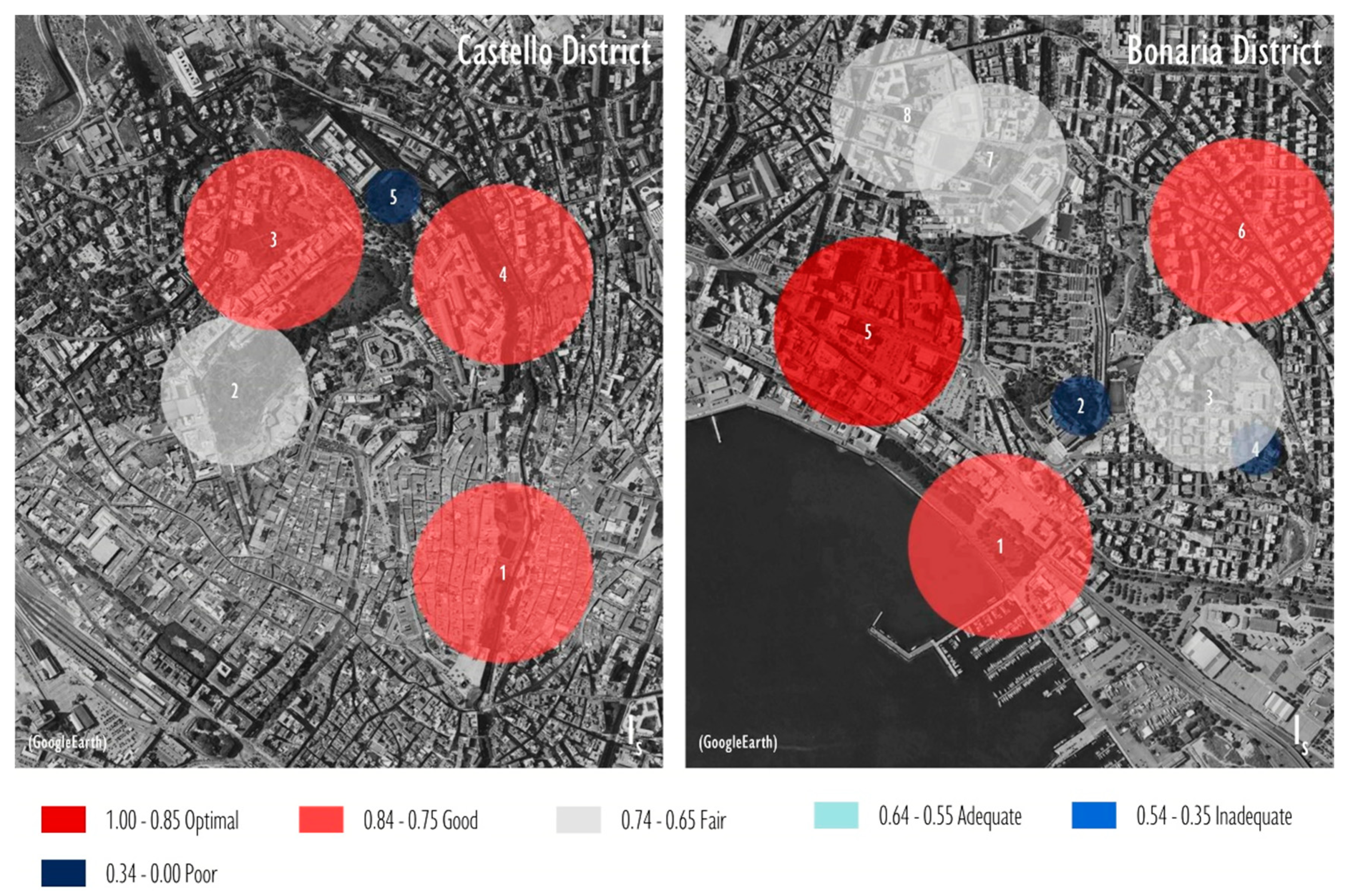
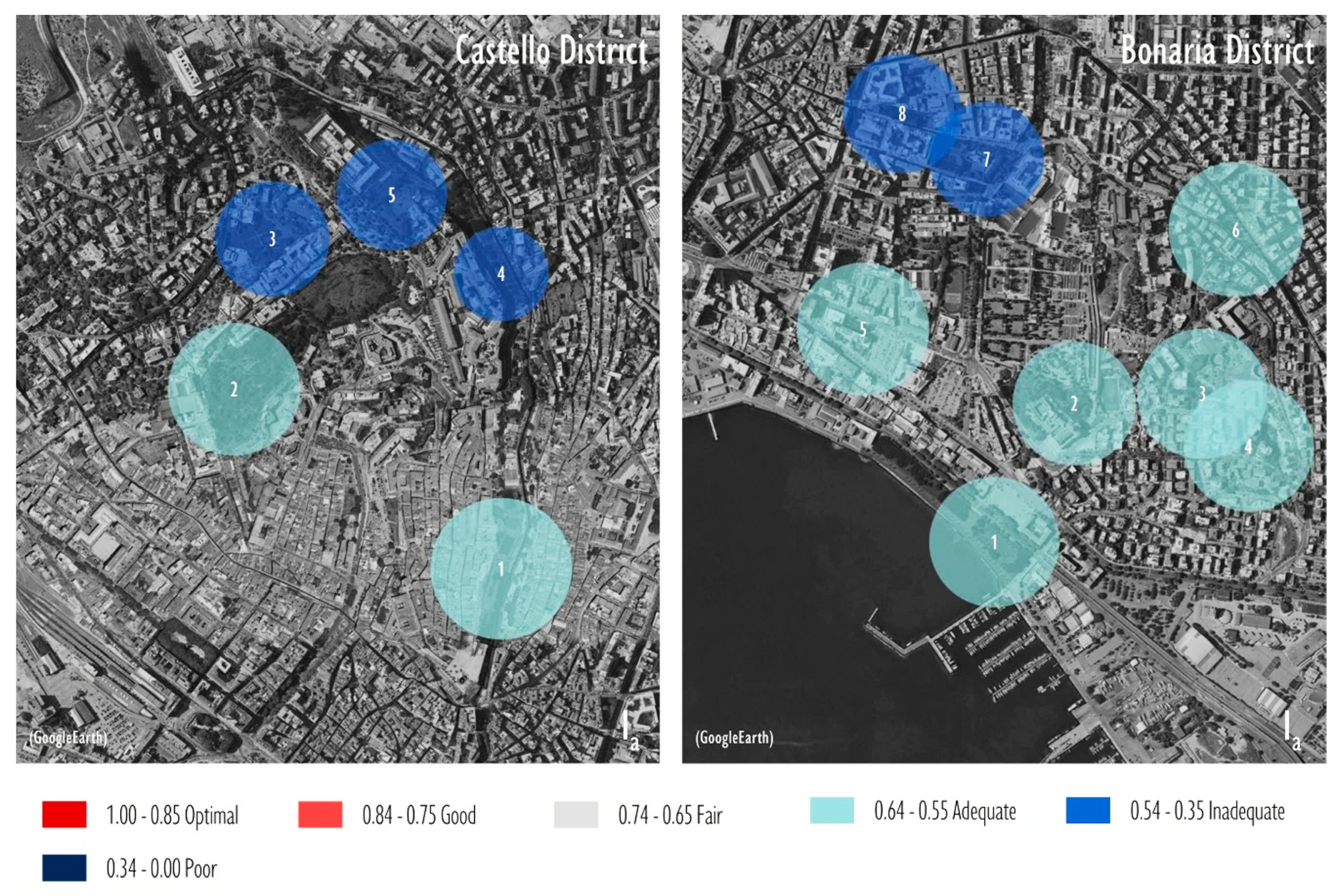
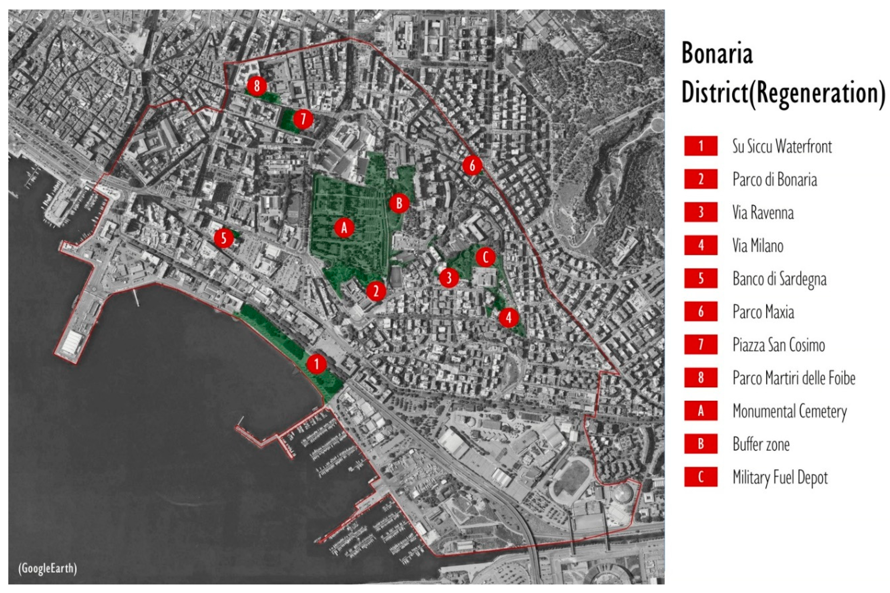
5. Results
6. Discussion
7. Conclusions
Author Contributions
Funding
Conflicts of Interest
References
- Martinotti, G. Sei Lezioni Sulla Città; Feltrinelli Editore: Milan, Italy, 2017; ISBN 978-880710530-2. [Google Scholar]
- Glaeser, E. Triumph of the City; Pan: Basingstoke, UK, 2011; ISBN 978-110147567-6. [Google Scholar]
- Armour, T.; Armour, S.; Hargrave, J.; Revell, T. Cities Alive: Rethinking Green Infrastructure; Arup: London, UK, 2014. [Google Scholar]
- Caragliu, A.; Del Bo, C.; Nijkamp, P. Smart cities in Europe. J. Urban Technol. 2011, 18, 65–82. [Google Scholar] [CrossRef]
- Min, B.; Lee, J. Children’s neighborhood place as a psychological and behavioral domain. J. Environ. Psychol. 2006, 26, 51–71. [Google Scholar] [CrossRef]
- Sen, A. Capability and Well-being. In The Quality of Life; Nussbaum, M., Sen, A., Eds.; Clarendon Press: Oxford, UK, 1993; pp. 30–53. [Google Scholar]
- Gibson, J.J. The Ecological Approach to Visual Perception; Lawrence Erlbaum: Hillsdale, NJ, USA, 1979. [Google Scholar]
- Barker, R.G.; Wright, H.F. Midwest and Its Children: The Psychological Ecology of an American Town; Row, Peterson: Evanston, IL, USA, 1954. [Google Scholar]
- Heft, H. Affordances of children’s environments: A functional approach to environmental description. Child. Environ. Q. 1988, 5, 29–37. [Google Scholar]
- UNICEF. Children in an Increasingly Urban World. 2012. Available online: https://www.unicef.org/sowc2012/pdfs/SOWC-2012-Chapter-1-Children-in-an-increasingly-urban-world.pdf (accessed on 31 March 2019).
- Goltsman, S.; Kelly, L.; McKay, S.; Algara, P.; Wight, L. Raising “free range kids”: Creating neighborhood parks that promote environmental stewardship. J. Green Build. 2009, 4, 90–106. [Google Scholar] [CrossRef]
- Lin, E.Y.; Witten, K.; Oliver, M.; Carroll, P.; Asiasiga, L.; Badland, H.; Parker, K. Social and built-environment factors related to children’s independent mobility: The importance of neighbourhood cohesion and connectedness. Health Place 2017, 46, 107–113. [Google Scholar] [CrossRef]
- Witten, K.; Kearns, R.; Carroll, P.; Asiasiga, L. Children’s Everyday Encounters and Affective Relations with Place: Experiences of Hyperdiversity in Auckland Neighbourhoods. 2017. Available online: https://0-www-tandfonline-com.brum.beds.ac.uk/doi/abs/10.1080/14649365.2017.1347700 (accessed on 10 August 2019).
- Chawla, L. Benefits of nature contact for children. J. Plan. Lit. 2015, 30, 433–452. [Google Scholar] [CrossRef]
- Giusti, M.; Svane, U.; Raymond, C.M.; Beery, T.H. A Framework to Assess Where and How Children Connect to Nature. Front. Psychol. 2018, 8, 2283. [Google Scholar] [CrossRef] [Green Version]
- Abson, D.J.; Fischer, J.; Leventon, J.; Newig, J.; Schomerus, T.; Vilsmaier, U.; von Wehrden, H.; Abernethy, P.; Ives, C.D.; Jager, N.D.; et al. Leverage points for sustainability transformation. Ambio 2017, 46, 30–39. [Google Scholar] [CrossRef]
- ISTAT. Ambiente Urbano. 2018. Available online: https://www.istat.it/it/archivio/225505 (accessed on 31 March 2019).
- Benedict, M.; McMahon, E. Green Infrastructure: Linking Landscapes and Communities; Island Press: Washington, DC, USA, 2006. [Google Scholar]
- Cannas, I.; Lai, S.; Leone, F.; Zoppi, C. Green Infrastructure and Ecological Corridors: A Regional Study Concerning Sardinia. Sustainability 2018, 10, 1265. [Google Scholar] [CrossRef]
- Tjallingii, S. Planning with water and traffic networks—Carrying structures of the urban landscape. In Flowscape—Designing Infrastructure as Landscape; Nijhuis, S., Jauslin, D., van Der Hoeven, F., Eds.; Delft University of Technology: Delft, NL, USA, 2015; pp. 57–80. ISBN 978-946186472-7. [Google Scholar]
- Boyd, J.; Banzhaf, S. What are ecosystem services? The need for standardized environmental accounting units. Ecol. Econ. 2007, 63, 616–626. [Google Scholar] [CrossRef] [Green Version]
- Millennium Ecosystem Assessment. Ecosystems and Human Well-Being; Island Press: Washington, DC, USA, 2005. [Google Scholar]
- Daily, G. Nature’s Services: Societal Dependence on Natural Ecosystems; Island Press: Washington, DC, USA, 1997; ISBN 1-55963-476-6. [Google Scholar]
- Landers, D.H.; Nahlik, A.M. Final Ecosystem Goods and Services Classification System (FEGS-CS). Available online: https://gispub4.epa.gov/FEGS/FEGS-CS%20FINAL%20V.2.8a.pdf (accessed on 27 May 2019).
- Wallace, K.J. Classification of ecosystem services: Problems and solutions. Biol Conserv. 2007, 139, 235–246. [Google Scholar] [CrossRef] [Green Version]
- Binning, C.; Cork, S.; Parry, R.; Shelton, D. Natural Assets: An Inventory of Ecosystem Goods and Services in the Goulburn Broken Catchment; Ecosystem Services Project: Canberra, Australia, 2001. [Google Scholar]
- Holt, A.R.; Mears, M.; Maltby, L.; Warren, P. Understanding spatial patterns in the production of multiple urban ecosystem services. Ecosyst. Serv. 2015, 16, 33–46. [Google Scholar] [CrossRef] [Green Version]
- Dennis, M.; James, P. Ecosystem services of collectively managed urban gardens: Exploring factors affecting synergies and trade-offs at the site level. Ecosyst. Serv. 2017, 26, 17–26. [Google Scholar] [CrossRef] [Green Version]
- Vogdrup-Schmidt, M.; Strange, N.; Olsen, S.B.; Thorsen, B.J. Trade-off analysis of ecosystem service provision in nature networks. Ecosyst. Serv. 2017, 23, 165–173. [Google Scholar] [CrossRef]
- Aarts, M.J.; Wendel-Vos, W.; van Oers, H.A.; van de Goor, I.A.; Schuit, A.J. Environmental determinants of outdoor play in children: A large-scale cross-sectional study. Am. J. Prev. Med. 2010, 39, 212–219. [Google Scholar] [CrossRef]
- Pyyry, N. Thinking with broken glass: Making pedagogical spaces of enchantment in the city. Environ. Educ. Res. 2017, 23, 1391–1401. [Google Scholar] [CrossRef]
- Nussbaum, M.C. Creating Capabilities; Harvard University Press: Cambridge, MA, USA, 2011; ISBN 978-067407235-0. [Google Scholar]
- Conrad, E. Human and social dimension of landscape stewardship. In The Science and Practice of Landscape Stewardship; Bieling, C., Plieninger, T., Eds.; Cambridge University Press: Cambridge, UK, 2017; pp. 38–53. ISBN 978-110714226-8. [Google Scholar]
- Matsuba, M.K.; Pratt, M.W.; Norris, J.E.; Mohle, E.; Alisat, S.; McAdams, D.P. Environmentalism as a context for expressing identity and generativity: Patterns among activists and uninvolved youth and midlife adults. J. Personal. 2012, 80, 1091–1115. [Google Scholar] [CrossRef]
- Kyttä, M.; Oliver, M.; Ikeda, E.; Ahmadi, E.; Omiya, I.; Laatikainen, T. Children as urbanites: Mapping the affordances and behavior settings of urban environments for Finnish and Japanese children. Child. Geogr. 2018, 16, 319–332. [Google Scholar] [CrossRef]
- Kyttä, M. The extent of children’s independent mobility and the number of actualized affordances as criteria for child-friendly environments. J. Environ. Psychol. 2004, 24, 179–198. [Google Scholar] [CrossRef]
- Barker, R.G.; Wright, H.F. One Boy’s Day: A Specimen Record of Behavior; Archon Books: Hamden, CT, USA, 1951; ISBN 978-0208004857. [Google Scholar]
- Lerstrup, I.; van den Bosch, C.K. Affordances of outdoor settings for children in preschool: Revisiting Heft’s functional taxonomy. Landsc. Res. 2017, 42, 47–62. [Google Scholar] [CrossRef]
- Broberg, A.; Kyttä, M.; Fagerholm, N. Child-friendly urban structures: Bullerby revisited. J. Environ. Psychol. 2013, 35, 110–120. [Google Scholar] [CrossRef]
- Geurs, K.T.; van Wee, B. Accessibility evaluation of land-use and transport strategies: Review and research directions. J. Transp. Geogr. 2004, 12, 127–140. [Google Scholar] [CrossRef]
- Whitzman, C.; Mizrachi, D. Creating child-friendly high-rise environments: Beyond wastelands and glasshouses. Urban Policy Res. 2012, 30, 233–249. [Google Scholar] [CrossRef]
- Kyttä, M. Children in Outdoor Contexts: Affordances and Independent Mobility in the Assessment of Environmental Child Friendliness. Ph.D. Thesis, Helsinki University of Technology, Helsinki, Finland, 2003. [Google Scholar]
- Kyttä, A.M.; Broberg, A.K.; Kahila, M.H. Urban environment and children’s active lifestyle: SoftGIS revealing children’s behavioral patterns and meaningful places. Am. J. Health Promot. 2012, 26, e137–e148. [Google Scholar] [CrossRef]
- Lopes, F.; Cordovil, R.; Neto, C. Independent Mobility and Social Affordances of Places for Urban Neighborhoods: A Youth-Friendly Perspective. Front. Psychol. 2018, 9, 2198. [Google Scholar] [CrossRef]
- Garau, C.; Annunziata, A.; Coni, M. A Methodological Framework for Assessing Practicability of the Urban Space: The Survey on Conditions of Practicable Environments (SCOPE) Procedure Applied in the Case Study of Cagliari (Italy). Sustainability 2018, 10, 4189. [Google Scholar] [CrossRef]
- Mygind, L.; Bentsen, P.; Badland, H.; Edwards, N.; Hooper, P.; Villanueva, K. Public open space desktop auditing tool—Establishing appropriateness for use in Australian regional and urban settings. Urban For. Urban Green. 2016, 20, 65–70. [Google Scholar] [CrossRef]
- Saelens, B.E.; Frank, L.D.; Auffrey, C.; Whitaker, R.C.; Burdette, H.L.; Colabianchi, N. Measuring physical environments of parks and playgrounds: EAPRS instrument development and inter-rater reliability. J. Phys. Act. Health 2006, 3 (Suppl. 1), S190–S207. [Google Scholar] [CrossRef] [PubMed]
- Rigolon, A.; Németh, J. A QUality INdex of Parks for Youth (QUINPY): Evaluating urban parks through geographic information systems. Environ. Plan. B Urban Anal. City Sci. 2016, 45, 275–294. [Google Scholar] [CrossRef]
- Moura, F.; Cambra, P.; Gonçalves, A.B. Measuring walkability for distinct pedestrian groups with a participatory assessment method: A case study in Lisbon. Landsc. Urban Plan. 2017, 157, 282–296. [Google Scholar] [CrossRef]
- Taleai, M.; Amiri, E.T. Spatial multi-criteria and multi-scale evaluation of walkability potential at street segment level: A case study of Tehran. Sustain. Cities Soc. 2017, 31, 37–50. [Google Scholar] [CrossRef]
- Garau, C.; Pavan, V.M. Evaluating Urban Quality: Indicators and Assessment Tools for Smart Sustainable Cities. Sustainability 2018, 10, 575. [Google Scholar] [CrossRef]
- Jabbari, M.; Fonseca, F.; Ramos, R. Combining multi-criteria and space syntax analysis to assess a pedestrian net-work: The case of Oporto. J. Urban Des. 2018, 23, 23–41. [Google Scholar] [CrossRef]
- Rosenberg, D.; Ding, D.; Sallis, J.F.; Kerr, J.; Norman, G.J.; Durant, N.; Harris, S.K.; Saelens, B.E. Neighborhood environment walkability scale for youth (NEWS-Y): Reliability and relationship with physical activity. Prev. Med. 2009, 49, 213–218. [Google Scholar] [CrossRef]
- Shaw, B.; Bicket, M.; Elliott, B.; Fagan-Watson, B.; Mocca, E.; Hillman, M. Children’s Independent Mobility: An International Comparison and Recommendations for Action; Policy Studies Institute: London, UK, 2015. [Google Scholar]
- Abis, E.; Garau, C. An assessment of the effectiveness of strategic spatial planning: A study of Sardinian municipalities. Eur. Plan. Stud. 2016, 24, 139–162. [Google Scholar] [CrossRef]
- Jacobs, J. The Death and Life of Great American Cities; Random House: New York, NY, USA, 1961; ISBN 978-067964433-0. [Google Scholar]
- Gehl, J. Cities for People; Island Press: Washington, DC, USA, 2013; ISBN 9781597265737. [Google Scholar]
- Lee, S.A.; Shusterman, A.; Spelke, E.S. Reorientation and landmark-guided search by young children: Evidence for two systems. Psychol. Sci. 2006, 17, 577–582. [Google Scholar] [CrossRef]
- Blečić, I.; Cecchini, A.; Congiu, T.; Fancello, G.; Trunfio, G.A. Evaluating walkability: A capability-wise planning and design support system. Int. J. Geogr. Inf. Sci. 2015, 29, 1350–1374. [Google Scholar] [CrossRef]
- Comune di Cagliari. Piano Urbanistico Comunale—Indirizzi Programmatici Operativi; Comune di Cagliari: Cagliari, Italy, 2017. (In Italian) [Google Scholar]
- Comune di Cagliari. Piano Particolareggiato Per il Centro storico, Progetti Strategici Per lo Spazio Pubblico; Comune di Cagliari: Cagliari, Italy, 2015. (In Italian) [Google Scholar]
- Hart, R. Children’s Experience of Place; Irvington: New York, NY, USA, 1979. [Google Scholar]
- Tonucci, F. Citizen child: Play as welfare parameter for urban life. Topoi 2015, 24, 183–195. [Google Scholar] [CrossRef]
- Villanueva, K.; Giles-Corti, B.; Bulsara, M.; Trapp, G.; Timperio, A.; McCormack, G.; Van Niel, K. Does the walkability of neighbourhoods affect children’s independent mobility, independent of parental, socio-cultural and individual factors? Child. Geogr. 2014, 12, 393–411. [Google Scholar] [CrossRef]
- Davis, A.; Jones, L.J. Children in the urban environment: An issue for the new public health agenda. Health Place 1996, 2, 107–113. [Google Scholar] [CrossRef]
- Nordström, M. Children’s views on child-friendly environments in different geographical, cultural and social neighbourhoods. Urban Stud. 2010, 47, 514–528. [Google Scholar] [CrossRef]
- Chaudhury, M.; Hinckson, E.; Badland, H.; Oliver, M. Children’s independence and affordances experienced in the context of public open spaces: A study of diverse inner-city and suburban neighbourhoods in Auckland, New Zealand. Child. Geogr. 2017, 17, 49–63. [Google Scholar] [CrossRef]
- Furneaux, A.; Manaugh, K. Eyes on the alley: children’s appropriation of alley space in Riverdale, Toronto. Child. Geogr. 2018, 17, 204–216. [Google Scholar] [CrossRef]
- Galvez, M.P.; McGovern, K.; Knuff, C.; Resnick, S.; Brenner, B.; Teitelbaum, S.L.; Wolff, M.S. Associations between neighborhood resources and physical activity in inner-city minority children. Acad. Pediatr. 2013, 13, 20–26. [Google Scholar] [CrossRef]
- Gillespie, J. Being and becoming: Writing children into planning theory. Plan. Theory 2013, 12, 64–80. [Google Scholar] [CrossRef]
- Villanueva, K.; Badland, H.; Kvalsvig, A.; O’Connor, M.; Christian, H.; Woolcock, G.; Giles-Corti, B.; Goldfeld, S. Can the neighborhood built environment make a difference in children’s development? Building the research agenda to create evidence for place-based children’s policy. Acad. Pediatr. 2016, 16, 10–19. [Google Scholar] [CrossRef]


| Affordance | Environmental Features | Indicator (Ind.) |
|---|---|---|
| Functional affordances | ||
| Walking, running, cycling, playing ball | Open ground | Ind. potential appropriation of open grounds (presence, size, quantity, variety) |
| Rolling/sliding/running down, rolling objects down, jumping down, jumping over, sitting in | Sloping terrain | Ind. potential appropriation of sloping terrains (presence, gradation, quantity, variety) |
| Hiding, as frame, microclimate | Repaired space | Ind. potential appropriation of repaired spaces (presence, quantity, variety) |
| Sitting-on, jumping, running around, hiding behind | Rigid features | Ind. potential transaction with rigid features (presence, quantity, variety) |
| Climbing, balancing on, hanging by arms, hanging in legs | Rigid climbable features | Ind. potential transaction with rigid climbable features (presence, quantity, variety) |
| Swinging on, dangling swaying in, seesawing on, spinning | Non-rigid, moving features | Ind. potential transaction with non-rigid moving features (presence, quantity, variety) |
| Drawing, scratching, throwing, hammering, batting, building | Loose objects | Ind. potential manipulation of loose objects (presence, quantity, variety) |
| Construction of objects, pouring, modification of surface features | Loose materials | Ind. potential manipulation of moldable materials (presence, quantity, variety) |
| Splashing, pouring, floating objects, drinking | Water | Availability of water (presence, quantity, variety, size) |
| Following, catching, caring for | Creatures | Presence of animals, insects, birds |
| Ensuring hygienic conditions | Lavatories | Availability of lavatories |
| Accessing web-based apps, communicating | Internet access | Internet coverage |
| Feeling safe | Natural control of the POS | Eyes on the POS |
| Pleasant place | Conspicuousness | Imageability of the POS |
| Quiet | Acoustic Environment | Quality of the acoustic environment |
| Breathing clean air | Pollution | Concentration of particulate matter |
| Clean public space | Maintenance of POS | Cleanliness of surfaces, equipment |
| Luminous | Illumination | Ind. of potential usability of the POS during night hours |
| Meeting friends | Meeting places | Presence or visibility of meeting places |
| Privacy/control | Sense of privacy and territoriality | Degree of children’s appropriation of spaces |
| Being with adults | Intergenerational activities | Presence of intergenerational activities |
| Make new friends | Anchor places | Presence of anchor places within a 400-m buffer (sports facilities, educational institutions, shopping malls, formal sites for play) |
| Lively | Presence of people | Degree of liveliness of the public space (density of retail activities and services; presence of outdoor activities) |
| Unpleasant/scary people/antisocial practices | Signs of neglect | Broken window |
| Access by collective transport | Access to mass transit | Proximity of collective transport nodes |
| Access by walking alone or with friends | Accessible pedestrian network | Category of contiguous pedestrian facilities |
| Dealing with vehicular traffic | Priority of vulnerable users and soft mobility modes | Barrier effect (main entrance or worst condition) |
| Access by cycling alone or with friends | Accessible bicycle facilities | Category of contiguous bicycle facilities |
| Access to other relevant places | Land-use diversity | Walk score |
| Frequent access | Residential density | (Prevailing typology/segments surrounding the POS) |
| Indicator | Type | Measurement | Scale | Score |
|---|---|---|---|---|
| Ind. potential appropriation of open grounds | Quantitative | Presence (binary evaluation) | Yes | 4 |
| No | 0 | |||
| Size (L1 and/or L2) | 70 m ≥ L1 and L2 > 25 m | 4 | ||
| 100 m ≥ L1 and/or L2 > 70 m | 3 | |||
| 25 m ≥ L1 and L2 > 15 m | 3 | |||
| 15 m ≥ L1 and/or L2 > 6 m | 2 | |||
| (L1 and/or L2) > 100 m | 1 | |||
| 6 m ≥ (L1 and/or L2) | 0 | |||
| Quantity | =1 region of open ground | 0 | ||
| =2 regions of open ground | 2 | |||
| >2 regions of open ground | 4 | |||
| Variety in terms of surface, size, geometry | Yes | 0 | ||
| No | 4 | |||
| Average | (S1 + S2 + S3 + S4)/4 | |||
| Density of retail activities and services | Quantitative | r/100 m; r = number of retail activities | 20 ≥ r/100 m > 16 | 4 |
| 16 ≥ r/100 m > 12 | 3 | |||
| 12 ≥ r/100 m > 8 | 2 | |||
| 8 ≥ r/100 m > 4 | 1 | |||
| 4 ≥ r/100 m ≥ 0 | 0 | |||
| Proximity of collective transport nodes | Quantitative | Distance from the nearest transport node | Dct ≤ 100 m | 4 |
| 200 m ≥ Dct > 100 m | 3 | |||
| 300 m ≥ Dct > 200 m | 2 | |||
| 400 m ≥ Dct > 300 m | 1 | |||
| Dct > 400 m | 0 | |||
| Degree of children’s appropriation of spaces | Qualitative | Degree of adults control of POSs | Restrictions on access | 0 |
| Constraints on uses | 1 | |||
| Competition for space | 2 | |||
| Time/coupling constraints | 3 | |||
| Manicured spaces | 3 | |||
| No constraints on activities | 4 |
| Index | Measurement | Scale | Rating |
|---|---|---|---|
| IUIS | (∑ICi)/P (P = 120) | 1.00 ≥ IUIS ≥ 0.85 | Optimal |
| 0.84 ≥ IUIS ≥ 0.75 | Good | ||
| 0.74 ≥ IUIS ≥ 0.65 | Fair | ||
| 0.64 ≥ IUIS ≥ 0.55 | Adequate | ||
| 0.54 ≥ IUIS ≥ 0.35 | Inadequate | ||
| 0.34 ≥ IUIS ≥ 0 | Poor | ||
| If; Ie; Is; Ia | (∑SII)/Pj, Pf = 48, Pe = 24, Ps = 24, Pa = 24 | 1.00 ≥ IUIS ≥ 0.85 | Optimal |
| 0.84 ≥ IUIS ≥ 0.75 | Good | ||
| 0.74 ≥ IUIS ≥ 0.65 | Fair | ||
| 0.64 ≥ IUIS ≥ 0.55 | Adequate | ||
| 0.54 ≥ IUIS ≥ 0.35 | Inadequate | ||
| 0.34 ≥ IUIS ≥ 0 | Poor | ||
| f | Apce/(∑Ai) | 1.00 ≥ IUIS ≥ 0.80 | Optimal |
| 0.79 ≥ IUIS ≥ 0.60 | Fair | ||
| 0.59 ≥ IUIS ≥ 0.45 | Inadequate | ||
| 0.44 ≥ IUIS ≥ 0 | Poor | ||
| ISGI | [(∑IUISi × Ai)/(∑Ai)] × f | 1.00 ≥ IUIS ≥ 0.85 | Optimal |
| 0.84 ≥ IUIS ≥ 0.75 | Good | ||
| 0.74 ≥ IUIS ≥ 0.65 | Fair | ||
| 0.64 ≥ IUIS ≥ 0.55 | Adequate | ||
| 0.54 ≥ IUIS ≥ 0.35 | Inadequate | ||
| 0.34 ≥ IUIS ≥ 0 | Poor |
| Urban BGI Components | Indexes of Meaningful Usefulness | ||
|---|---|---|---|
| IUIS | Continuity Factor f | ISGI | |
| Giardino Sotto le Mura (1) | 0.72 | ||
| HBK (2) | 0.76 | ||
| Orto dei Cappuccini (3) | 0.74 | ||
| Giardini Pubblici (4) | 0.74 | ||
| Viale Buoncammino (5) | 0.53 | ||
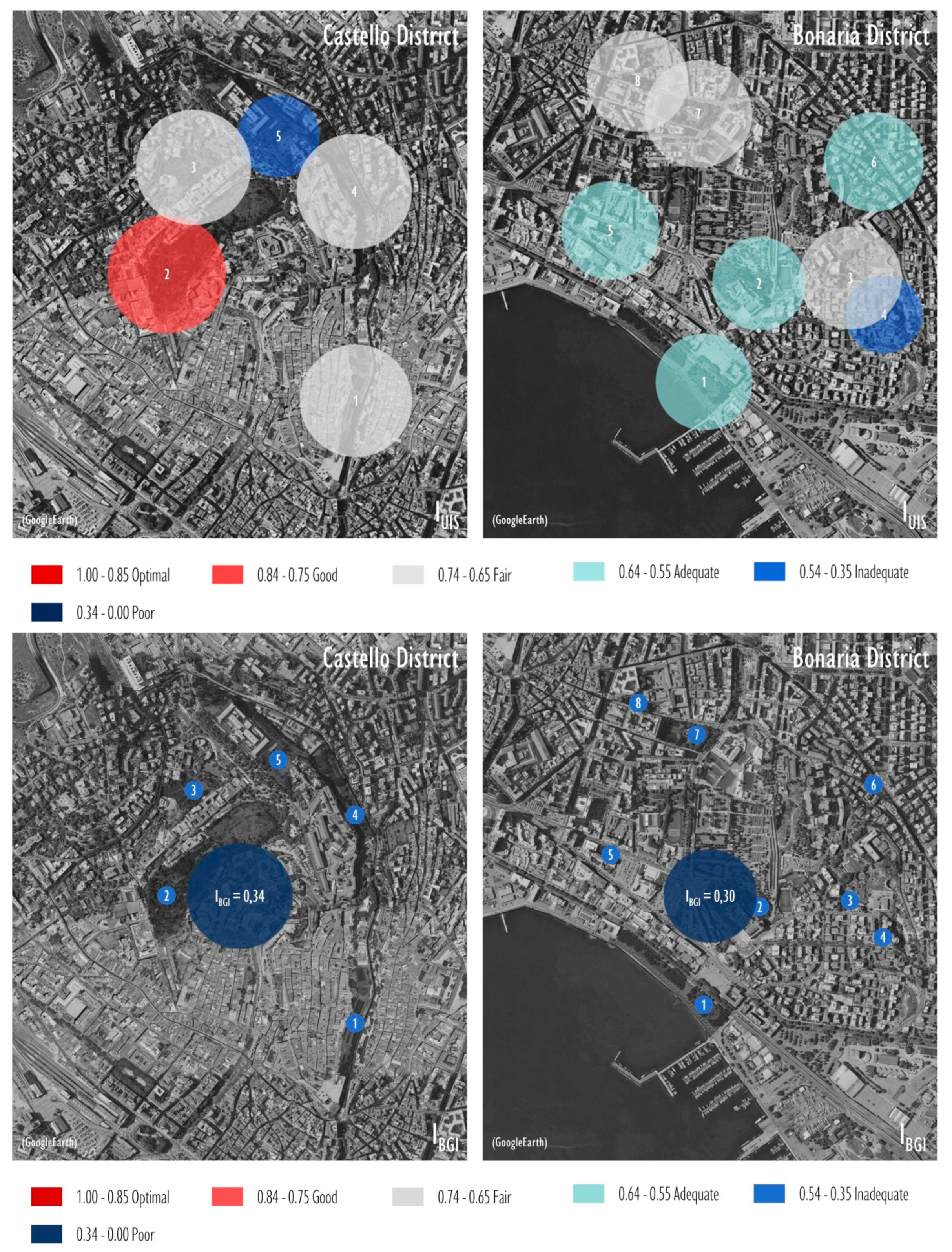
| Castello district | 0.71 | 0.48 | 0.34 |
| Su Siccu (1) | 0.62 | ||
| Parco Bonaria (2) | 0.60 | ||
| Via Ravenna (3) | 0.66 | ||
| Via Milano (4) | 0.50 | ||
| Banco di Sardegna (5) | 0.63 | ||
| Parco Maxia (6) | 0.64 | ||
| Piazza San Cosimo (7) | 0.69 | ||
| Parco Martiri Foibe (8) | 0.65 | ||
| Bonaria district | 0.62 | 0.48 | 0.30 |
| Urban BGI Components | Indexes of Meaningful Usefulness | |||
|---|---|---|---|---|
| If (Functional) | Ie (Emotional) | Is (Social) | Ia (Access) | |
| Giardino Sotto le Mura (1) | 0.67 | 0.78 | 0.81 | 0.64 |
| HBK (2) | 0.86 | 0.83 | 0.67 | 0.60 |
| Orto dei Cappuccini (3) | 0.77 | 0.83 | 0.81 | 0.52 |
| Giardini Pubblici (4) | 0.79 | 0.89 | 0.81 | 0.43 |
| Viale Buoncammino (5) | 0.71 | 0.49 | 0.25 | 0.50 |
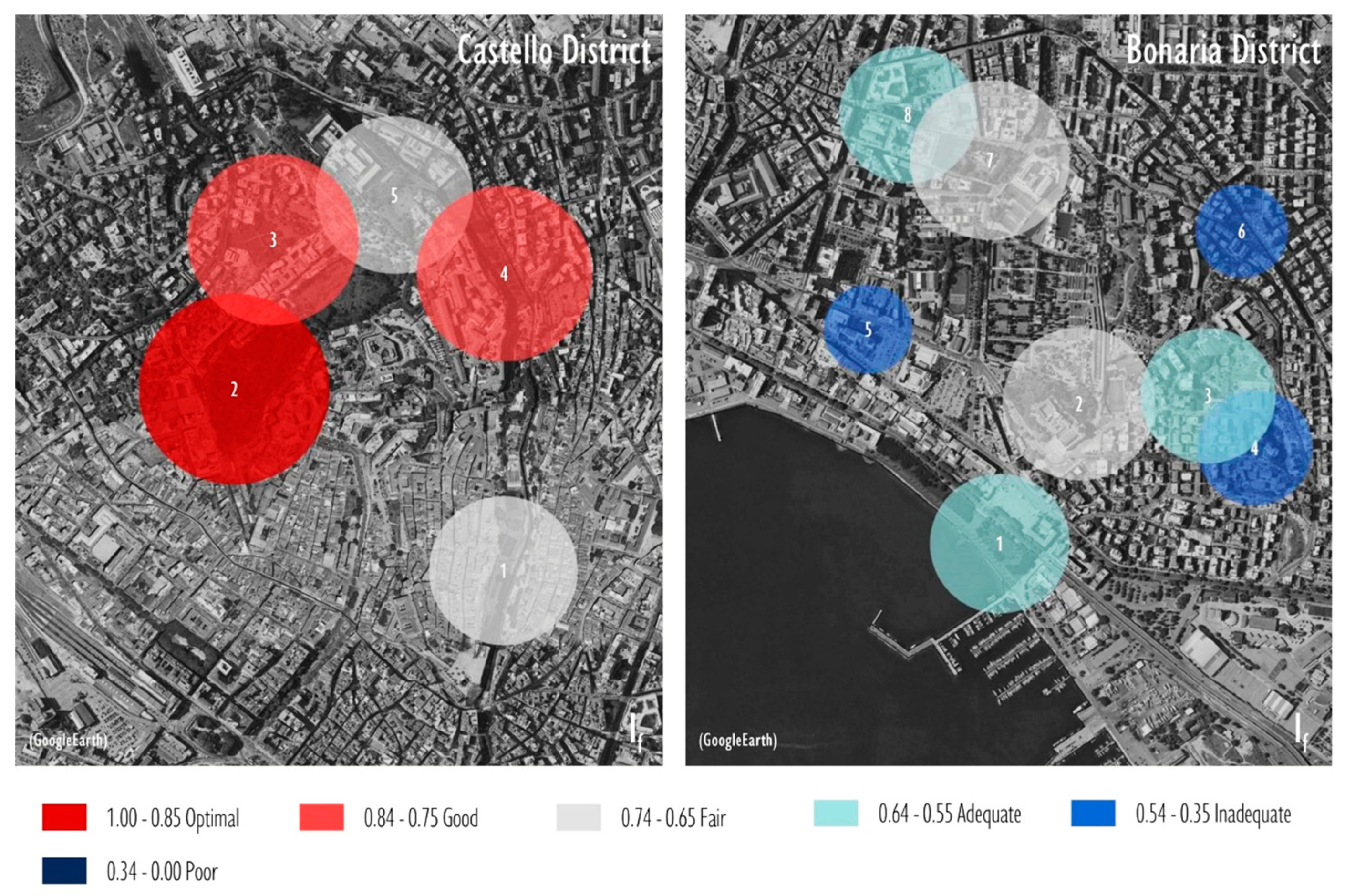
| Castello district | 0.79 | 0.76 | 0.63 | 0.55 |
| Su Siccu (1) | 0.63 | 0.42 | 0.83 | 0.59 |
| Parco Bonaria (2) | 0.69 | 0.78 | 0.27 | 0.56 |
| Via Ravenna (3) | 0.61 | 0.81 | 0.67 | 0.59 |
| Via Milano (4) | 0.52 | 0.64 | 0.23 | 0.59 |
| Banco di Sardegna (5) | 0.40 | 0.88 | 0.85 | 0.60 |
| Parco Maxia (6) | 0.42 | 0.93 | 0.83 | 0.61 |
| Piazza San Cosimo (7) | 0.72 | 0.82 | 0.69 | 0.52 |
| Parco Martiri Foibe (8) | 0.62 | 0.77 | 0.69 | 0.54 |
| Bonaria district | 0.63 | 0.61 | 0.66 | 0.57 |
© 2019 by the authors. Licensee MDPI, Basel, Switzerland. This article is an open access article distributed under the terms and conditions of the Creative Commons Attribution (CC BY) license (http://creativecommons.org/licenses/by/4.0/).
Share and Cite
Garau, C.; Annunziata, A. Smart City Governance and Children’s Agency: An Assessment of the Green Infrastructure Impact on Children’s Activities in Cagliari (Italy) with the Tool “Opportunities for Children in Urban Spaces (OCUS)”. Sustainability 2019, 11, 4848. https://0-doi-org.brum.beds.ac.uk/10.3390/su11184848
Garau C, Annunziata A. Smart City Governance and Children’s Agency: An Assessment of the Green Infrastructure Impact on Children’s Activities in Cagliari (Italy) with the Tool “Opportunities for Children in Urban Spaces (OCUS)”. Sustainability. 2019; 11(18):4848. https://0-doi-org.brum.beds.ac.uk/10.3390/su11184848
Chicago/Turabian StyleGarau, Chiara, and Alfonso Annunziata. 2019. "Smart City Governance and Children’s Agency: An Assessment of the Green Infrastructure Impact on Children’s Activities in Cagliari (Italy) with the Tool “Opportunities for Children in Urban Spaces (OCUS)”" Sustainability 11, no. 18: 4848. https://0-doi-org.brum.beds.ac.uk/10.3390/su11184848