Molecular No Smart-Planning in Italy: 8000 Municipalities in Action throughout the Country


Department of Civil and Environmental Engineering, University of L’Aquila, 67100 L’Aquila, Italy
*
Author to whom correspondence should be addressed.
Sustainability 2019, 11(22), 6467; https://doi.org/10.3390/su11226467
Submission received: 19 October 2019
/
Revised: 12 November 2019
/
Accepted: 15 November 2019
/
Published: 17 November 2019
(This article belongs to the Special Issue Smart Urban Planning and Land Management)
Abstract
:This paper discusses the topic of urban and spatial planning in Italy where decision-making is left almost exclusively to the innumerable, small municipalities present in the country and totaling almost 8000 in number. Projects and actions to transform built areas, infrastructure, and welfare services of all sorts and purposes in a national territory of over 300,000 km2 are supervised by countless mayors, municipal councils, and boards that govern plots of land corresponding to polygons of a few kilometers per side. This is generally achieved by means of town plans developed outside of any general rule or protocol, the contents of which are often ignored as a result of national legislation that weakens them and sometimes makes them uninfluential essentially. This is a European example of urban planning mismanagement that deserves to be brought to the broader attention of the European technical and scientific community, also because the debate developed so far on this topic—even by eminent and authoritative urban planners—has been published almost entirely in Italian only. Public and political attention towards this issue is extremely limited, although the severe effects of “molecular planning” are beginning to be perceived: unjustified overurbanization and highly patchy, energy-intensive, urban patterns that are destructive for ecosystems and at odds with public interests regarding environmental and urban quality. In this paper, we make some comparisons with other European countries and outline some directions—certainly very difficult to follow—to reconsider and recover from the adverse effects produced to date.
1. Introduction
This paper analyzes the phenomenon of the virtually utmost autonomy that Italian municipalities enjoy in the management of urban and spatial planning, without being subject to almost any higher strategic supervision, highlighting some of the most glaring and negative consequences and putting forward a course for at least partial recovery. This condition has gradually worsened amid generalized indifference in the course of some decades, but its pathological aspects have been seized only recently: unjustified overurbanization and highly patchy, energy-intensive, urban patterns that are destructive for ecosystems and at odds with public interests regarding environmental and urban quality. Actually, some evidence of the inefficiency of Italian planning had already emerged in the 1980s, thanks to eminent and farsighted academics, but unfortunately almost all the literature produced is in Italian and therefore in our references we have included many titles, although we are fully aware that they may be difficult to consult.
Although Italian historical city centers preserve significant landscape and architectural quality acknowledged and appreciated worldwide, the urban fabric developed over the past 50 years probably has on average the worst distribution, construction, and formal features, at least in Europe. It is certainly true that the Italian urban planning law dated 1942 (Law no. 1150 dated 17 August 1942,) was one of the first and most innovative, as it introduced multi-level planning and urban development plans extended to entire municipal territories and limited the building activities of municipalities lacking urban development plans. However, it is also a fact that many of these noteworthy contents, amongst which the power of public expropriation in expanding areas, have either never been implemented at all or have been, but through modalities that have lost regulatory strength over the decades. After 1942, Italy failed to enact national laws on urban development or land transformation and starting from the 1970s, lawmaking in this field was delegated to the 20 regions present in the country. Although very intensive over time, this activity has been marked by significant inhomogeneity and once again weak strategic regulatory capabilities, thus gradually easing existing forms of supervision and leaving decision-making more and more to municipalities, however small and demographically irrelevant they may be [1,2,3,4].
A completely different conduct was adopted by other European countries, such as France, Germany, and Great Britain, that since the 1970s, have implemented national planning policies and enacted legislation favoring forms of strategic approach to planning [5,6,7,8]. In these countries too, there is vertical/hierarchical supervision of decisions concerning land transformation, construction, and infrastructure (very similar to what has been theoretically in place in Italy since 1942), that however, is enforced more strictly and is actually more efficient.
In France, there has been profound reorganization [9,10] from the 1970s to 2017 aimed at setting up inter-municipal associations that manage the Schéma de la Coherence Territoriale (SCOT) that in turn monitor the municipal Plan Local d’Urbanisme (PLU). The modernization of local government has been the subject of national legislation even in 2015 (Law no. 991) leading to the substantial reduction of the so-called “millefeuille territorial” through the merger of local agencies, thus promoting inter-municipality. According to Gibelli [11] “there is not the slightest opportunity for privates to propose urban transformation/regeneration projects derogating from the urban development plans in force and involving simplified approval procedures… and all the various, unlikely stories and neologisms used to reward real estate finance over the past decades in Italy”.
As of 1965, the reorganization of the regulations concerning “regional planning” (Raumordnungsgesetz) was initiated in Germany, later further improved in 1975 (“General Regional Planning Program for the Federal Territory” (Raumordnungsprograrmme fur die gross raumige Entwicklung des Bundesgebiet) [12,13,14]. The key players of physical planning are the 160 Länder through the “Territorial Plans” (Landesraumordnungsprogramme) and the “Development Plans” (Landes Entwicklungsprogramme), which control the regional plans (Regionalpläne), the plans of the kreis, and the “Urban Land-Use Plans” (Bauleitplanung). Archibugi [15] stated over forty years ago that “this is a complex system of highly integrated ‘cascading’ plans (despite some differences in name and structure due to the legislative autonomy of the Länder), in an orderly sequence of further specifications that make them particularly efficient. From this standpoint, an “institutional framework” could not be more operational and thus more effective and this is visible “to the naked eye” when travelling through the country, owing to the visual perception of great order and supervision achieved in the territorial development of Germany”.
In 1971, the regulation of territorial matters in Great Britain was initiated, in order to assure a vertically and horizontally integrated process in all planning activities [16,17,18]. The actual spatial planning level provided by the “institutional framework”, reorganized and made more functional by the 1971 act, is that of “Counties” that are the most important local organization agency with broad administrative autonomy. There are over 60 counties in Great Britain that draw up structure plans that are submitted mandatorily to the central authorities for approval (the Department for Environment) and are full-fledged integrated territorial, socio-economic, and physical planning documents. The subsequent levels of spatial planning concern “districts” (of which there are 93—[19]) that each county is broken down into and that may draw up three types of plans: the district plan (development and land use), the action area plan (urban renewal), and the subject plan (sectoral development). The county authorities draft the Development plan schemes and the close links between local plans and structure plans assure the important vertical integration of territorial planning, while structure plans assure horizontal integration.
We have limited our overview to three European countries, but experiences of an orderly, and even more thorough and effective “institutional framework” can also be found in the Netherlands, Belgium, Denmark, and Sweden, while different results come from other countries [20,21]. Major Italian town planners—unfortunately mostly in documents and papers written in Italian—have criticized national conduct in the field of planning even very fiercely, such as the substantial relinquishment of strategic action and coordination and the lax and ineffectual way of leaving decision-making entirely in the hands of municipalities, that is to say, almost 8000 small territorial bodies where speculative interests and the utmost level of uncontrollability and dispersion of actions are concentrated.
Regarding what Indovina [22] called the “the diffuse city” and later, the “metropolitan archipelago”, again Gibelli [10] underlines that “all legislative reforms were aimed at favoring income and deregulation, certainly not the protection of land as a collective asset”.
Again, Archibugi [15] is very harsh “we measure the gap produced, above all over the past two decades, between the albeit slow experimentation that has occurred elsewhere and the sterile, disinformed and boorish verbalism that has prevailed in this country (Italy). Here in Italy, caught between administrative and bureaucratic idleness, speculative wheelings and dealings, ideological schematism and, above all, ignorance, we were not even able to make the few technical and professional structures that we had in the 1960’s work”.
In Italy, the results of these procedures, introduced between the 1960s and the 1970s, are clear for all to see and a detailed description of processes was recently written, again only in Italian unfortunately, in an excellent volume by Blečić [23] on the unfulfilled Sullo reform.
2. Material and Methods
Municipalities originated in the Middle Ages as a secular response to the management of public authorities previously entrusted to the ecclesiastical authorities. They consolidated over an extremely long historical period, with alternating protagonism and roles, until they acquired their present-day geography. After the Fascist era, municipalities strengthened their identity increasingly and when in 2014 the reform of administrative levels was discussed, the Del Rio law (Law no.56 dated 7 April 2014) abolished the provinces, but merely provided for the possible merger of municipalities. This law also identified 14 metropolitan cities (comprising 1275 municipalities) with about 22 million inhabitants (one third of the total), but the municipalities forming them retained the opportunity of planning autonomously, albeit within the framework of a Metropolitan Territorial Plan having functions of coordination.
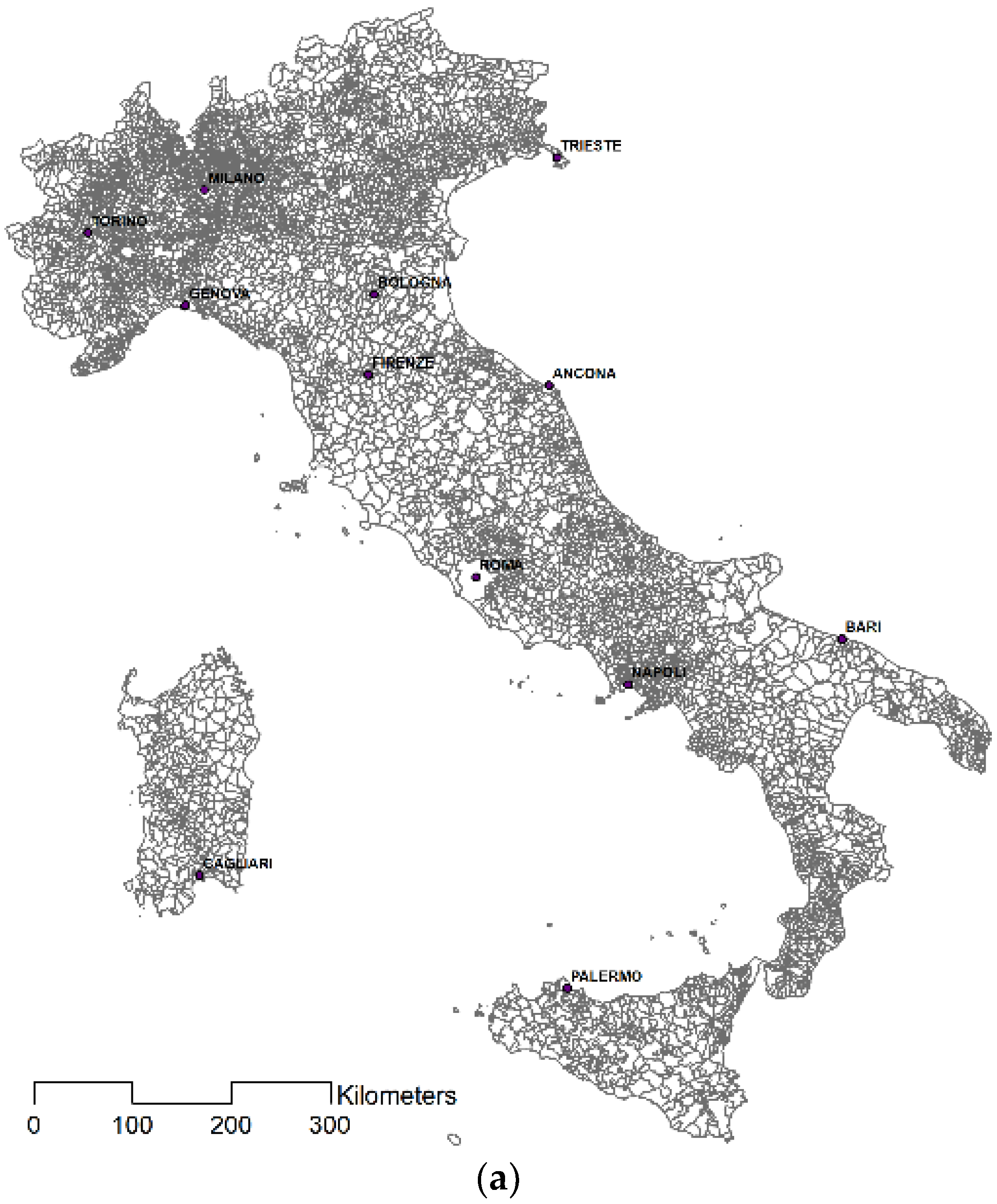
For the rest, municipalities have retained their prerogative of utmost sovereignty and only in recent years has their number dropped slightly, from the over 8100 to the current 7955. The data used in our study refer to the last dataset provided by ISTAT (Central Institute of Statistics) in 2018 (Figure 1a) and thus, the classification by size class (Figure 1b) is based on this data. This geographical dataset was compounded by the data obtained from the ISTAT population from 1861 to 2018.
For the current state of municipal planning, we used the data found in the 2016 INU (National Urban Planning Institute) report which, every two years, reports on the Italian condition regarding the different levels and forms of territorial planning [24].
For data processing tied to the example of the region of Umbria, we used the mosaicking of the general town planning schemes (PRGs) developed for the “updating and completion of plans for the management of regional protected natural areas” (PSR 2007-2013-Measure 3.2. action a- Reg. (EC) 1698/2005) of 2015 and LIFE SUN (LIFE13 NAT/IT/000371) projects dated 2014–2018.
The data on the mosaicking of municipal urban development plans in the region of Lombardy were extrapolated from the regional geoportal http://www.geoportale.regione.lombardia.it/download-ricerca.
The methodology used is based on a first phase of classification of municipal dimensions to highlight the consistency of very small, small, and medium surfaces. With rules that entrust all operational planning to the municipalities, this data can be considered an indicator of the effectiveness of the planning itself since the more the plan is built on a reduced spatial dimension, the less it can strategically manage its contents towards the territory of interest. In the second methodological phase, a survey is carried out on the regional distribution of the different size classes of the municipalities, obtaining a comparison result between the significant aggregation of the very small dimensions in some Italian regions and the update figure of the municipal plans on the entire peninsular arc. In the third and final phase, an investigation is carried out on some regional samples concerning the correspondence between the demographic dynamics in the period 1991–2018 and the theoretical increase of the urbanized areas extracted from the municipal planning instruments in force, verifying how this last value is constantly positive regardless of the actual positive or negative demographic trends. This last methodological point opens an interesting perspective of transferability of the contents of the present work to other national and international contexts. In particular, it could be important to elaborate a coherence analysis between the urban growth modalities proposed by the plans and the effective social and economic growth of the territories to determine an indicator of credibility of the development policies.
3. Results
The first result of the research highlights how the small size of the municipalities is such that they cannot be considered as drivers of fundamental decisions on urban transformations as they are incapable of strategic vision.
The smallest municipalities in Italy, covering an area below 10 km2, are one fifth of the national total, but account for 55% if we consider medium-small sized municipalities as well (S < 25 km2) (Table 1).
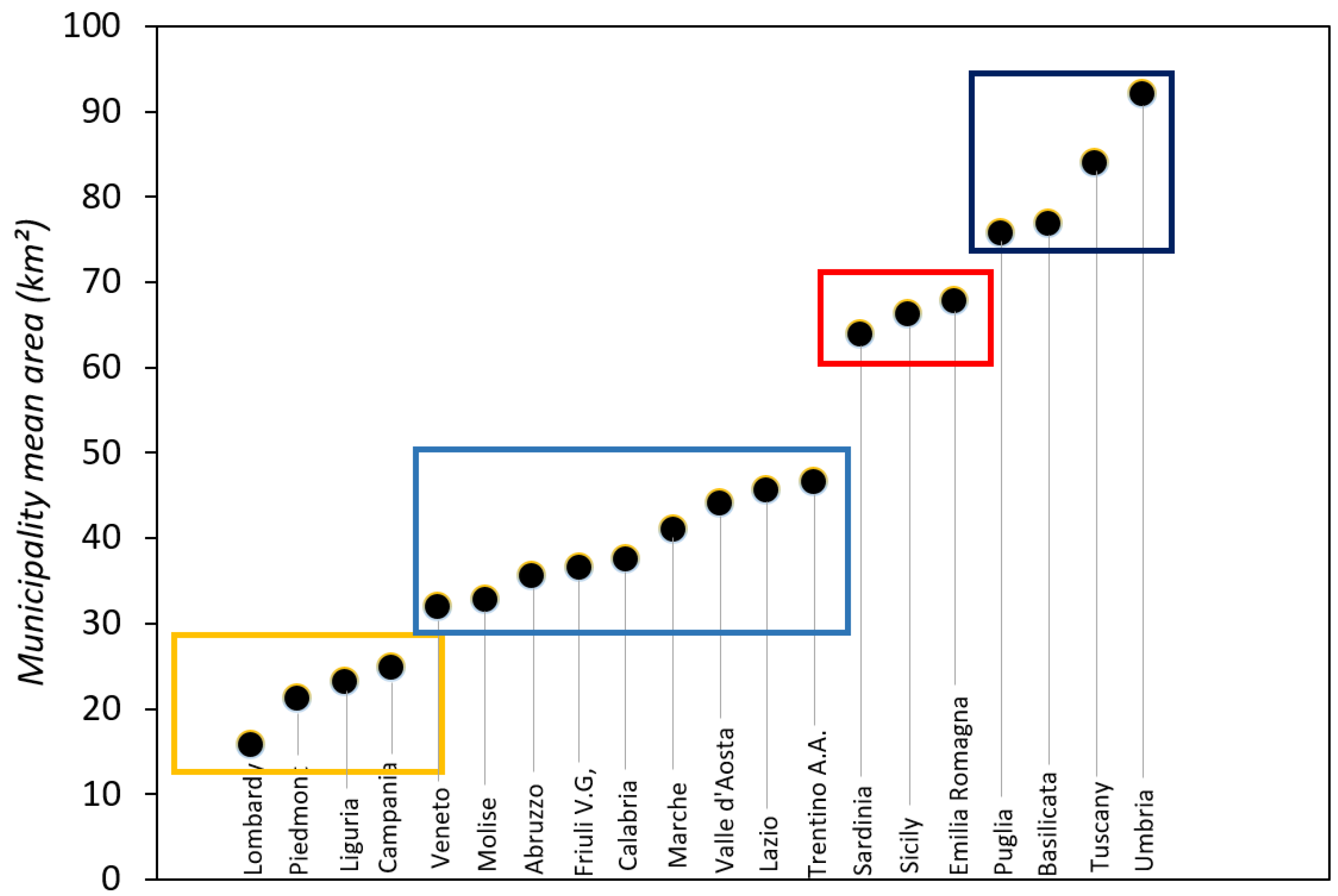
The geographical distribution per region of size classes is fairly clear-cut and the cluster is evident in Figure 2, although classifying the various groups of regions from a geo-historical perspective, according to the average size range of their municipalities, is rather difficult. Indeed, there is no latitudinal gradient, that usually characterizes many Italian phenomena of all sorts, nor a morphological one, considering that the regions having mostly small and very small municipalities can be found both in the mountainous and flat areas in the north and the flat and hilly areas in the south. On the other hand, despite the existence of papers in literature (again in Italian only), it is simply not feasible to trace the evolution of perimeters over 10 centuries [25,26], although we are fully aware that the determinants are tied to geo-morphology, ownership, land, production, and even military conquests.
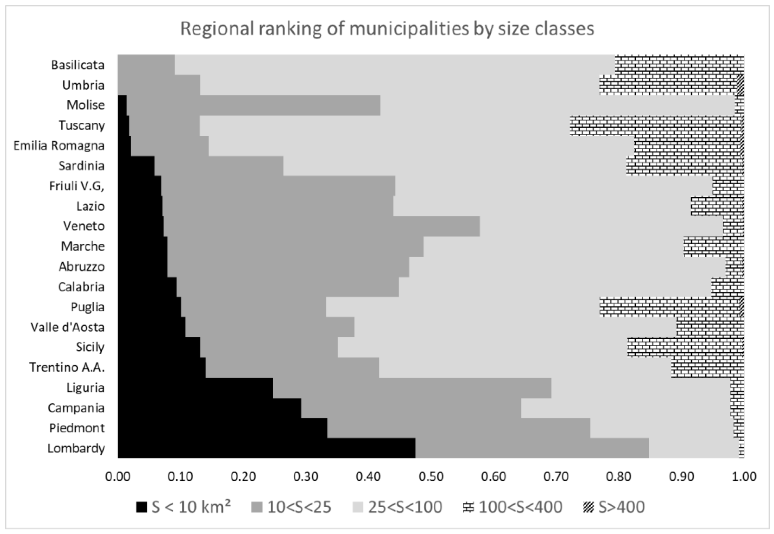
Seventy-seven percent of the smallest municipalities in Italy (<10 km2) are however concentrated in three regions (Table 1): Lombardy, Piedmont, and Campania, and the Lombardy region has almost half of the territory managed by these very small municipalities (Figure 3). These municipalities are the ones that have the highest urbanization density overall: 18%, almost three-fold the national mean, dropping down to 10% in the subsequent class and then up to 5%–7% in the largest municipality classes (Table 1), and this is something that has already been highlighted by some authors [27,28].
Almost one third of Italian urban areas (31%) falls within about 4400 separate administrative units, and are thus planned and managed in terms of size and function by the latter, with decision-making limited to areas corresponding to squares with sides of less than 5 km. Moreover, one third of these, that is to say, 10% of national urbanized areas, refers to 1667 municipalities governing even smaller areas, i.e., squares with sides below 3 km.
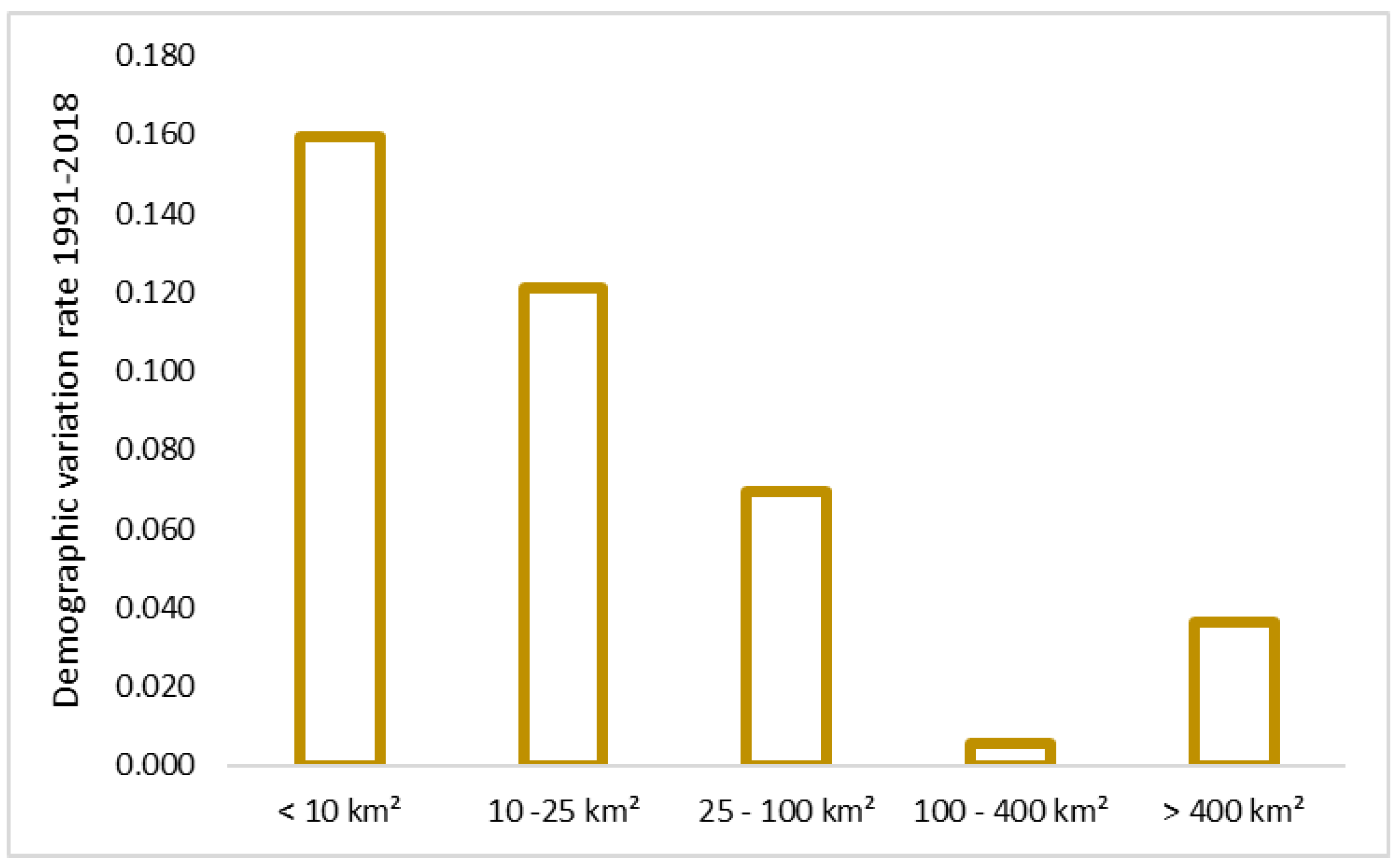
The overall population in smaller municipalities amounts to just over 5,700,000 inhabitants, that is to say approximately 10% of the Italian population (Table 1) and the highest demographic increases in percentage terms over the twenty years between 1991 and 2018 have occurred in these municipalities (Figure 4) and decline proportionally as the surface areas of municipalities increase, except for a slight ascent in correspondence with the larger municipalities. The reasons for this phenomenon have long been well-known and are essentially tied to rising demographic density in the municipalities surrounding large urban areas and the reduced residential appeal of the latter owing to congestion and high real estate costs [28]. Hence, it follows that the plans of the smallest municipalities, i.e., the ones that are less manageable through broader strategies, are faced with the most significant urban growth dynamics in many cases.
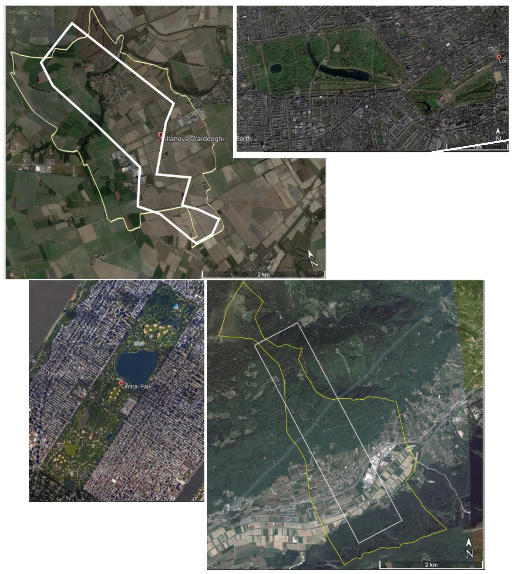
Given they are sometimes very small size, it is highly difficult to consider them players in planning efforts that have credible contents. As shown in the pictures in Figure 5, municipal areas are the size of a large urban square or big metropolitan park, and besides, with very little environmental, settlement, and/or morphological heterogeneity that can hardly be linked to the typical issues of a urban/territorial plan, albeit with limited complexity. Considering also their minimal demographic and urban development burden, it is unjustified to regard these municipalities as independent territorial authorities pursuing land transformation policies and deciding on land-use changes that often have a huge local or sub-regional impact.
The second result of the research shows that, in addition to often very small dimensions, the municipalities are equipped with very old planning tools and therefore unable to grasp the most recent environmental and socio-economic issues.
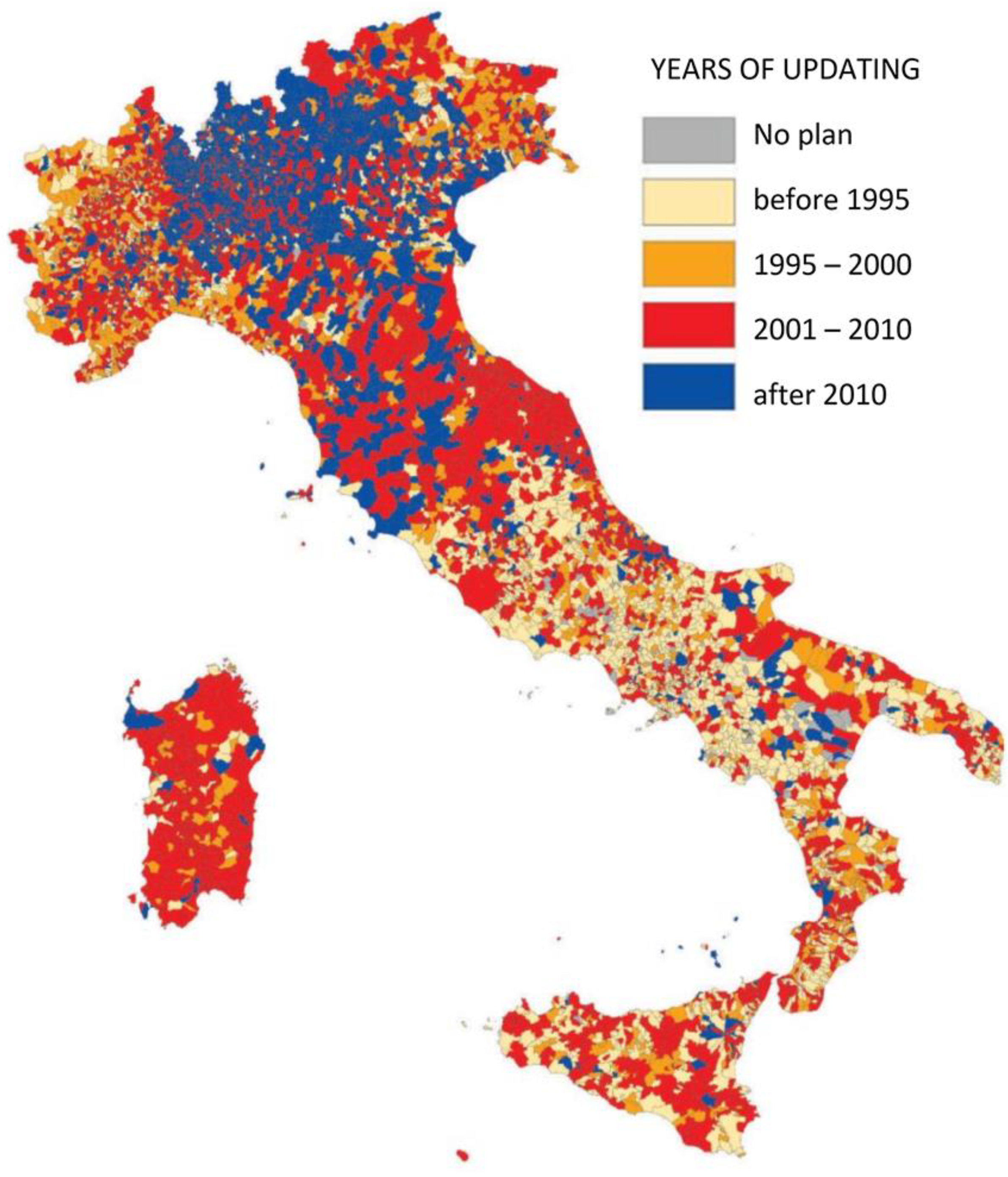
However, town-planning schemes are developed even intensively. Figure 6 shows that planning continuity over time is closely connected to the sensitivity of regions. Firstly, Lombardy, Emilia Romagna, and Tuscany are the only regions that have municipal plans updated over the past 8 years, which is extremely rare in the rest of Italy. Municipalities in central and southern Italy are lagging behind considerably in the updating of their plans, with an extremely high proportion of plans dating back to almost 25 years ago (i.e., before 1995) and a certain number of plans (in Sardinia and to a lesser extent Sicily) dating back to 10–20 years ago. Figure 6 also clearly shows that town planning in Italy is tied to very heterogeneous factors influenced by the cultural and political conditions of individual municipalities (a clear example is the Puglia–Basilicata–Calabria patchwork, in south Italy), which suggests the total lack of central coordination and the low efficiency of results.
Furthermore, there are no national databases where the contents of plans are entered following their approval and so it is not possible to calculate how many new settlement areas have been envisaged by each municipality, nor of what sort they are, thus making any form of supervision or governance of land use on a national scale unrealistic, as instead is the case in some European countries, such as Germany. The mosaicking of municipal town planning schemes is entirely optional and available only on the geoportals of some regions (e.g., Lombardy, Emilia Romagna, Piedmont, and Campania), but is developed freely in the absence of any standardization protocols.
The third result of the research shows through two regional examples how, in all the municipalities, the new and old urban plans always foresee a growth of urbanized surfaces completely independently from the real demographic dynamics.
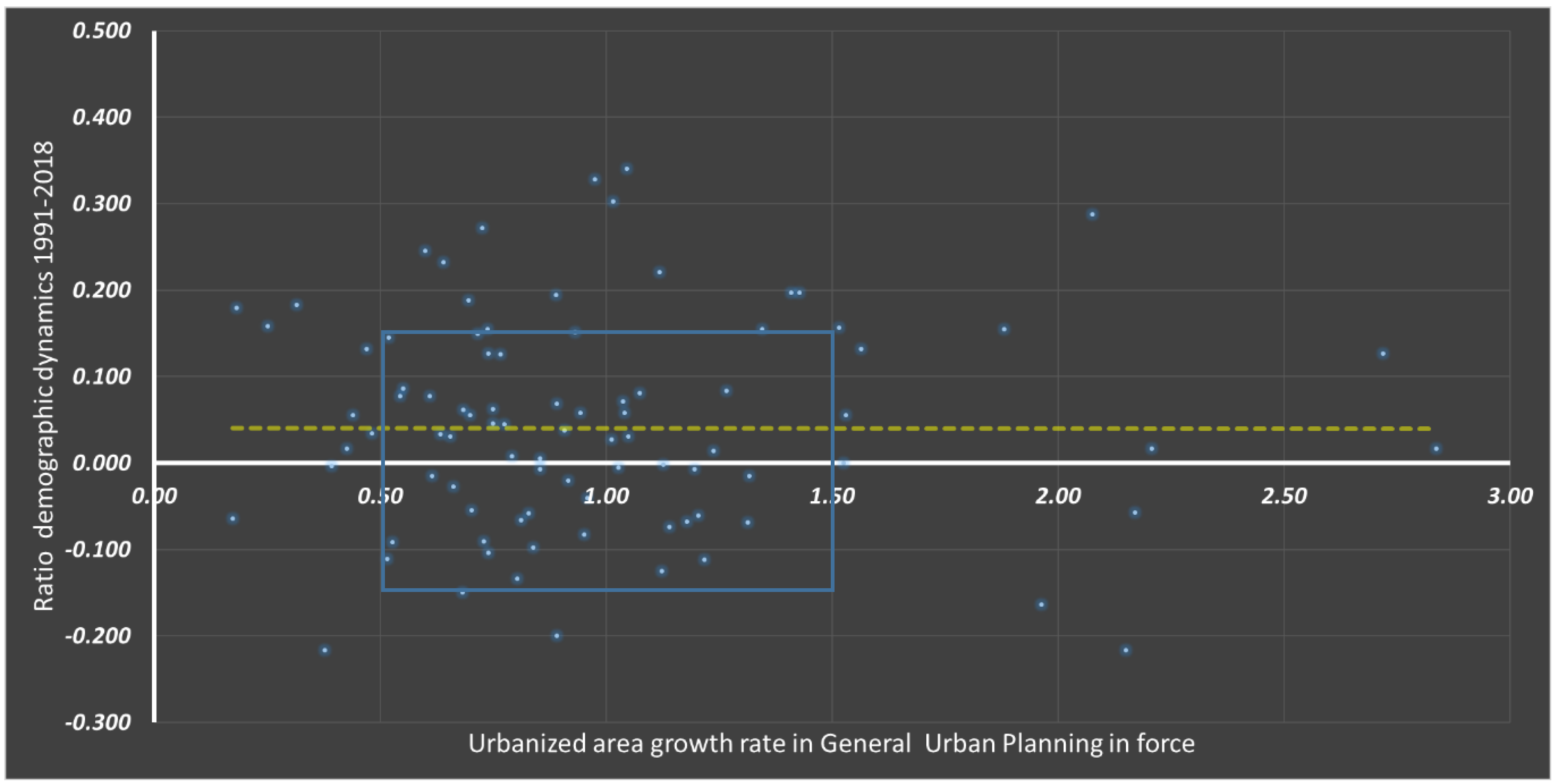
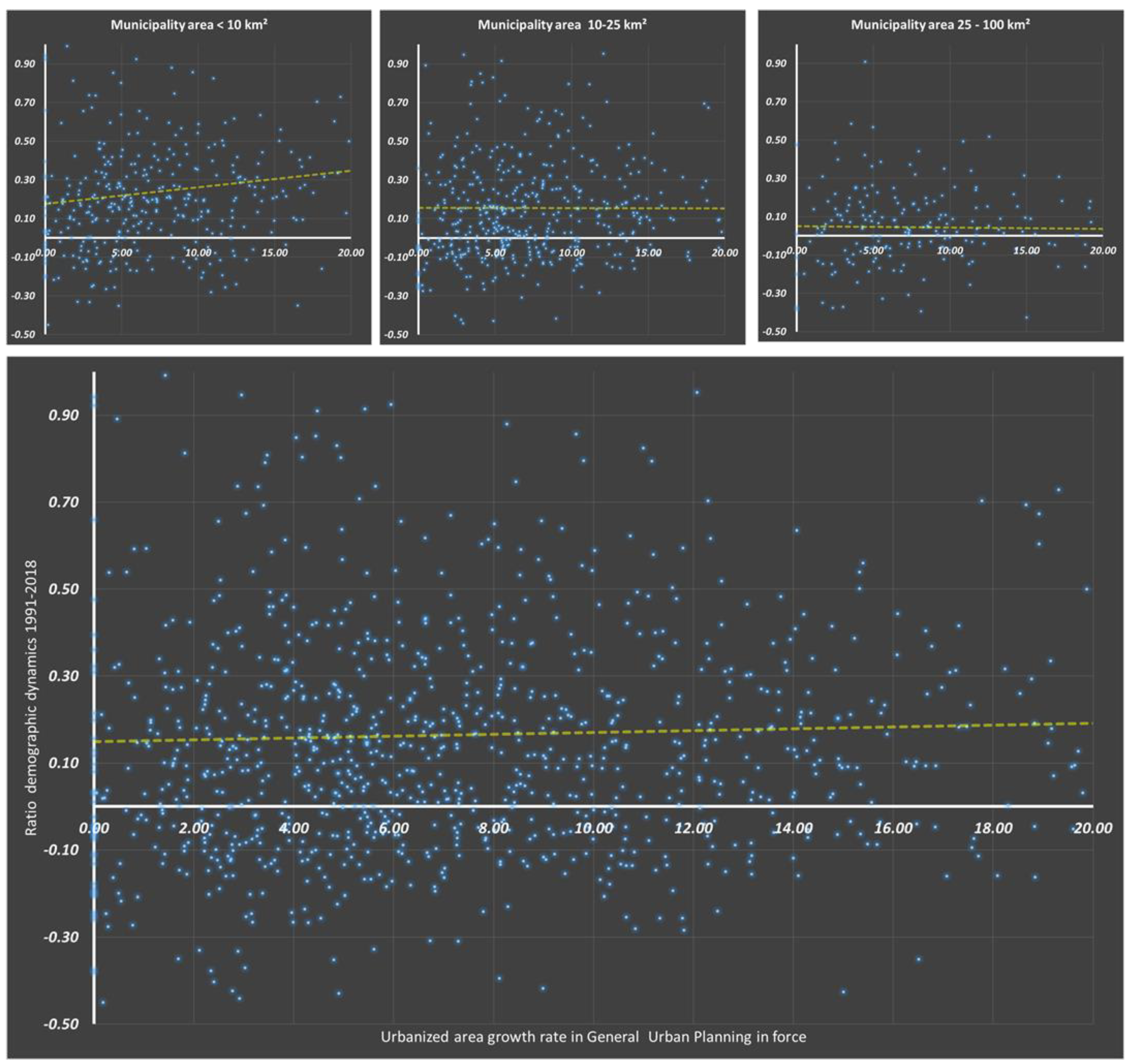
In general, the plans of municipalities, as a norm, abound in demographic projections to support the building of new, large residential or industrial areas, both when the population is on the rise, but also when these projections are objectively contradicted by long-standing population decline. This claim can be verified by using the sample from the region of Umbria, for which a detailed and updated mosaic of general town planning schemes (PRGs) is available. Excluding very few exceptions, the 92 municipal plans of the region, of which over half updated after 2010 and another 23 after 2005, envisage an increase in urbanized areas ranging between 50% and 150% and some municipalities exceed even 200%–250% (Figure 7). These rates are extremely high, as they concern municipalities that have witnessed demographic increases over the past twenty years (at any rate not exceeding 20%), but also innumerable municipalities with only slight population growth or demographic stability (<5%) or even with significant population decline nearing or above 10%. The dispersion of the point cloud in Figure 7 shows that there is basically no difference between past demographic dynamics and expansion ambitions of municipalities, which is, once again, evidence of the excessive decision-making autonomy and profound lack of coordination in Italian municipal planning. In the case of Umbria, which currently boasts a per capita urbanization rate of about 350 m2/inhabitant, the increase in urbanization established in plans (+84%) corresponds to almost double the present-day 884,000 inhabitants over a 10–20-year timeframe: a speculated 3.5% per annum that is entirely unreasonable given the population trend over the past 50 years marked by a mean growth rate of about 2‰. The situation described for Umbria also applies to a sample of municipalities with an urbanization density (UD) ranging between 3‰ and no more than 10%, but very different results can be obtained by investigating municipalities in Lombardy, the Italian region, together with Veneto, with the highest mean UD rate (about 14%). The over 1500 municipalities in Lombardy, the mean size of which is the lowest in Italy as shown earlier (Figure 2 and Figure 3), have very high urbanization levels, up to 94% and almost 500 of them have over 25% (one quarter) of their territory covered by settlements. Considering only those with a UD below 25%, the situation differs from the one in Umbria in terms of absolute values. The diagrams in Figure 8 show the significant concentration of samples falling in the planned expansion range, between 0% and 10% of present-day urbanization, and up to 20% in the sparser part of the cloud. As in the case of Umbria, there is basically no difference with rising or falling population ranging between +100% and −20% and this applies both to all the municipalities considered and to their size clusters. Furthermore, in both cases, there is no significant distribution per value-related or geographical sub-areas. Regarding the plans in Lombardy, there is a tendency to limit urban expansion, probably owing to high saturation in the region and also due to the fact that almost all the general town planning schemes (PRGs) are very recent, as shown in Figure 6, that is to say, drafted after 2010, when the national debate on land take started to gain ground.
Throughout Italy, this significant phenomenon of expansion is compounded by the issue of spatial pattern. New areas are built without any general supervision, even from a spatial perspective, driven only by criteria of participation or negotiations between the technical bureaus of municipalities and the economic and social representatives of residing communities, with hardly negligible unlawful influences that have emerged both in the past and today, and not only in the south of the country [29,30,31]. This entails numerous pathological, social, energy, and ecosystem-related consequences, due especially to the excessive dispersion of tiny built/urbanized parts in the territory, sometimes very isolated from the main agglomerations (Figure 9) and marked by considerable functional heterogeneity. These effects have given rise to the phenomenon of “sprinkling” recently identified as an alternative Italian model to the international standard of sprawl and defined after lengthy research [32,33].
4. Discussion
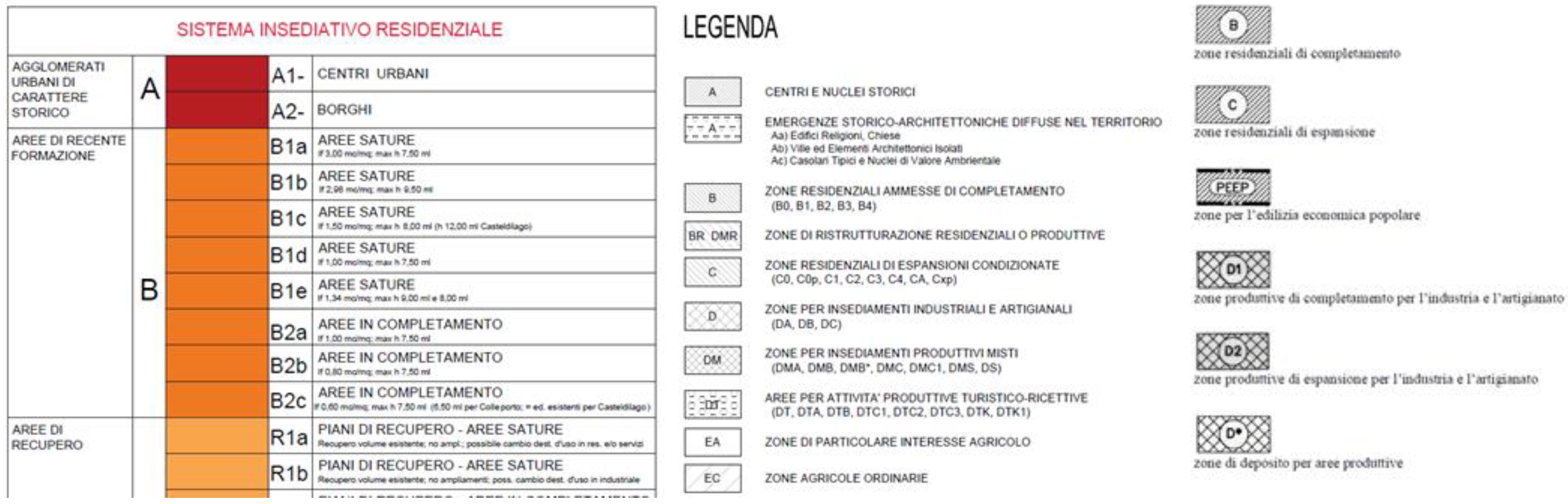
From our previous considerations, it is clear that Italian planning has many weaknesses that make it highly ineffective, if not useless or harmful. At this moment in time, the topic discussed in this paper is not considered or under debate in any political forum, but only within a restricted niche of technical and scientific experts, and so we cannot expect it to be tackled paradigmatically or from a regulatory viewpoint, at least within the next 5 years. However, in the meantime, it would be necessary to make some adjustments at least regarding the various forms of blatant deregulation: a commendable and useful result would be to at least reduce/eliminate differences in syntax, contents, and interpretations between zoning and rules of individual plans, introduce the regional mosaicking of municipal urban development plans, as an institutional layer, for the ongoing monitoring of changes, and adopt rules and protocols for the technical drafting of plans in terms of technical and digital (Geographical Information System-GIS, Computer Aided Design - CAD, etc.) output. These three measures would at least make it possible to query individual plans in real time and hence devise scenarios of the future layout of the territory, both in terms of size and function. However, the changes undergone by the territory are the sum of the various contents of plans and can therefore only be assessed in the mid- and long-term or a posteriori, but having the opportunity to assess them using the same key to their interpretation would make monitoring easier for regions which today are faced with huge difficulties, given the “8000 different dialects” which Pileri [34] has come across in his “Piccolo Dizionario Urbanistico Italiano” (Concise Dictionary of Italian Town Planning). This consideration is clearly evidenced by Figure 10 where we see a comparison between three summary tables taken from different general town planning schemes (PRGs) with huge differences in definitions and representation of zones used for different purposes that undoubtedly hinder any comparative and quantitative assessment.
5. Conclusions
The work demonstrates, in a fairly clear manner, the inadequacy of the current Italian territorial planning system focused on the municipalities and substantially devoid of strategic vision. At least two aspects highlighted in the research underline this pathology: first, the excessive diffusion of obsolete municipal plans that for many years have not been able to collect the most recent territorial needs [35]. Secondly, the total and absurd independence of the urban evolution perspectives always positive in the face of demographic dynamics, in some cases even drastically negative, to witness the distance from the reality of the territories that the plans of the municipalities very often express, almost becoming “books of dreams” that, however, on medium-long times, cause serious groundless and extensive land take phenomena. Today, GIS platforms help manage “town” planning using consolidated and effective big data technology, even on very large and strategic scales, as in the case of regions, but national territorial culture lacks the sensitivity and readiness to engage in such an effort.
In fact, this would entail the profound re-organization of national and regional urban development legislation, assigning a decision-making role to regional land planning, especially regarding settlements, thus reinstating a top-down approach and assigning implementation, management and participatory roles to municipalities and excluding the latter from decision-making. This would be a Copernican revision of European importance that should stem from social and political players gaining awareness of this issue and involve a radical national, and to some extent, constitutional reform. After all, we do not see other alternatives to counter the build-up of effects caused by half a century of disjointedness and unsustainability of urban settlements and built-up areas that some have defined as the “post-urban” era, although it would be far more correct to define it “post-smart” era, especially as this concerns a country that offers the world almost 30 UNESCO (United Nations Educational, Scientific and Cultural Organization) sites formed by historical cities.
Author Contributions
Conceptualization, B.R. Data curation, F.Z., L.F. Software, A.M. Supervision, B.R. Writing—original draft, B.R.
Funding
This research received no external funding.
Acknowledgments
The methodology and the indicators used have been developed within the framework of the SUNLIFE project (LIFE 13/NAT/IT/000371—Strategy for the N2000 Network of the Umbria Region). We thank Cheryl Di Lorenzo for her precious collaboration in the preparation of the text and the anonymous reviewers who, with their comments, have allowed us to significantly improve the quality of the paper.
Conflicts of Interest
The authors declare no conflicts of interest.
References
- Ave, G. Urban Land and Property Markets in Italy; UCL Press: London, UK, 1996; p. 206. ISBN 9781857280531. [Google Scholar]
- Sartorio, F.S. Strategic spatial planning: A historical review of approaches, its recent revival, and an overview of the state of the art in Italy. Plan. Rev. 2005, 41, 26–40. [Google Scholar] [CrossRef]
- Gabellini, P. Profiles of Italian urban planning. PLANUM 2008, 17, 1–15. [Google Scholar]
- Colavitti, A.M.; Usai, N.; Bonfiglioli, S. Urban Planning in Italy: The Future of Urban General Plan and Governance. Eur. Plan. Stud. 2012, 21, 167–186. [Google Scholar] [CrossRef]
- Newman, P.; Thornley, A. Urban Planning in Europe: International Competition, National Systems, and Planning Projects; Routledge: London, UK, 1996; p. 277. ISBN 0-203-42794-7. [Google Scholar]
- Healey, P.; Williams, R. European urban planning systems: Diversity and convergence. Urban Stud. 1993, 30, 701–720. [Google Scholar] [CrossRef]
- Naess, P. Urban planning and sustainable development. Eur. Plan. Stud. 2001, 9, 503–524. [Google Scholar] [CrossRef]
- Couch, C.; Sykes, O.; Börstinghaus, W. Thirty years of urban regeneration in Britain, Germany and France: The importance of context and path dependency. Prog. Plan. 2011, 75, 1–52. [Google Scholar] [CrossRef]
- John, P.; Cole, A. Urban regimes and local governance in Britain and France: Policy adaption and coordination in Leeds and Lille. Urban Aff. Rev. 1998, 33, 382–404. [Google Scholar] [CrossRef]
- Weber, C. Interaction model application for urban planning. Landsc. Urban Plan. 2003, 63, 49–60. [Google Scholar] [CrossRef]
- Gibelli, M.C. In Italia, ci Pensa il Mercato; Invece, in Francia i Piani Urbanistici Diventeranno Intercomunali! Carte in Regola. 2018. Available online: http://www.carteinregola.it/index.php/i-piani-urbanistici-in-francia-e-in-italia/ (accessed on 19 July 2018).
- Wiegandt, C. Urban development in Germany: Perspectives for the future. GeoJournal 2000, 50, 5–15. [Google Scholar] [CrossRef]
- Pauleit, S.; Duhme, F. Assessing the environmental performance of land cover types for urban planning. Landsc. Urban Plan. 2000, 52, 1–20. [Google Scholar] [CrossRef]
- Schmidt, S.; Buehler, R. The Planning Process in the US and Germany: A Comparative Analysis. Int. Plan. Stud. 2007, 12, 55–75. [Google Scholar] [CrossRef]
- Archibugi, F. La pianificazione territoriale: la funzionalità del quadro istituzionale ai vari livelli. In Proceedings of the 2° Congresso National di Architettura: Politiche edilizie e urbanistiche in Italia, Rome, Italy, 1–3 July 1981; Available online: http://www.francoarchibugi.it/pdf/81-11-%20La%20pianificazone%20territ...pdf (accessed on 16 November 2019).
- Cullingworth, J.B.; Nadin, V. Town and Country Planning in the UK; Routledge: London, UK, 2006; p. 573. ISBN 0-415-35809-4. [Google Scholar]
- Sager, T. Neo-liberal Urban Planning Policies: A Literature Survey, 1990-2010. Prog. Plan. 2011, 76, 199. [Google Scholar] [CrossRef]
- Lord, A.; Tewdwr-Jones, M. Is planning “Under Attack”? Chronicling the deregulation of urban and environmental planning in England. Eur. Plan. Stud. 2014, 22, 345–361. [Google Scholar] [CrossRef]
- EUROSTAT. Regions in the European Union. Nomenclature of Territorial Units for Statistics NUTS 2006 /EU-27; EUROSTAT: Luxembourg, 2007. [Google Scholar]
- Abrantes, P.; Fontes, I.; Gomes, E.; Rocha, J. Compliance of land cover changes with municipal land use planning: Evidence from the Lisbon metropolitan region (1990–2007). Land Use Policy 2016, 51, 120–134. [Google Scholar] [CrossRef]
- Tiana, L.; Lib, Y.; Yanc, Y.; Wangc, B. Measuring urban sprawl and exploring the role planning plays: A Shanghai case study. Land Use Policy 2017, 67, 426–435. [Google Scholar] [CrossRef]
- Indovina, F. Dalla Città Diffusa All’arcipelago Metropolitano; FrancoAngeli: Milan, Italy, 2009; p. 298. ISBN 9788856811704. [Google Scholar]
- Blecic, I. Lo Scandalo Urbanistico 50 Anni Dopo: Sguardi e Orizzonti Sulla Proposta di Riforma di Fiorentino Sullo, Italy ed.; Franco Angeli Edizioni: Milan, Italy, 2017; p. 202. ISBN 978-88-917-2774-9. [Google Scholar]
- INU. Rapporto Dal Territorio 2016; INU: Rome, Italy, 2016; ISBN 978-88-7603-153-3. [Google Scholar]
- Milani, G. I Comuni Italiani Secoli XII-XIV; Laterza: Bari, Italy, 2009; p. 200. [Google Scholar]
- ANCI-IFEL. 1861–2011, L’italia dei Comuni, 150 Anni di Unità, ANCI ed.; ANCI-IFEL: Rome, Italy, 2011; p. 89. [Google Scholar]
- Oueslati, W.; Alvanides, S.; Garrod, G. Determinants of urban sprawl in European cities. Urban Stud. 2015, 52, 1594–1614. [Google Scholar] [CrossRef]
- Romano, B.; Zullo, F. Half a century of urbanisation in Southern European lowlands a study on the Po Valley (Northern Italy). J. Urban Res. Pract. 2015, 9, 109–130. [Google Scholar] [CrossRef]
- de Biase, C.; Losco, S. Up-granding Illegal Building Settlements: An Urban-Planning Methodology. Procedia Environ. Sci. 2017, 37, 454–465. [Google Scholar] [CrossRef]
- Pinotti, P. The Economic Costs of Organised Crime: Evidence from Southern Italy. Econ. J. 2015, 125, F203–F232. [Google Scholar] [CrossRef]
- Zanfi, F. The Città Abusiva in Contemporary Southern Italy: Illegal Building and Prospects for Change. Urban Stud. 2013, 50, 3428–3445. [Google Scholar] [CrossRef]
- Romano, B.; Zullo, F.; Fiorini, L.; Ciabò, S.; Marucci, A. Sprinkling: An Approach to Describe Urbanization Dynamics in Italy. Sustainability 2017, 9, 97. [Google Scholar] [CrossRef]
- Romano, B.; Zullo, F.; Fiorini, L.; Marucci, A.; Ciabò, S. Land transformation of Italy due to half a century of urbanisation. Land Use Policy 2017, 67, 387–400. [Google Scholar] [CrossRef]
- Pileri, P. 100 Parole Per Salvare il Suolo. Piccolo Dizionario Urbanistico-Italiano; Altraeconomia: Milan, Italy, 2017; p. 190. ISBN 9788865162835. [Google Scholar]
- Romano, B.; Zullo, F.; Marucci, A.; Fiorini, L. Vintage Urban Planning in Italy: Land Management with the Tools of the Mid-Twentieth Century. Sustainability 2018, 10, 4125. [Google Scholar] [CrossRef] [Green Version]
Figure 1.
Italian municipalities (a) and their classification per size category (b).


Figure 2.
Mean size clusters of municipalities in Italian regions.

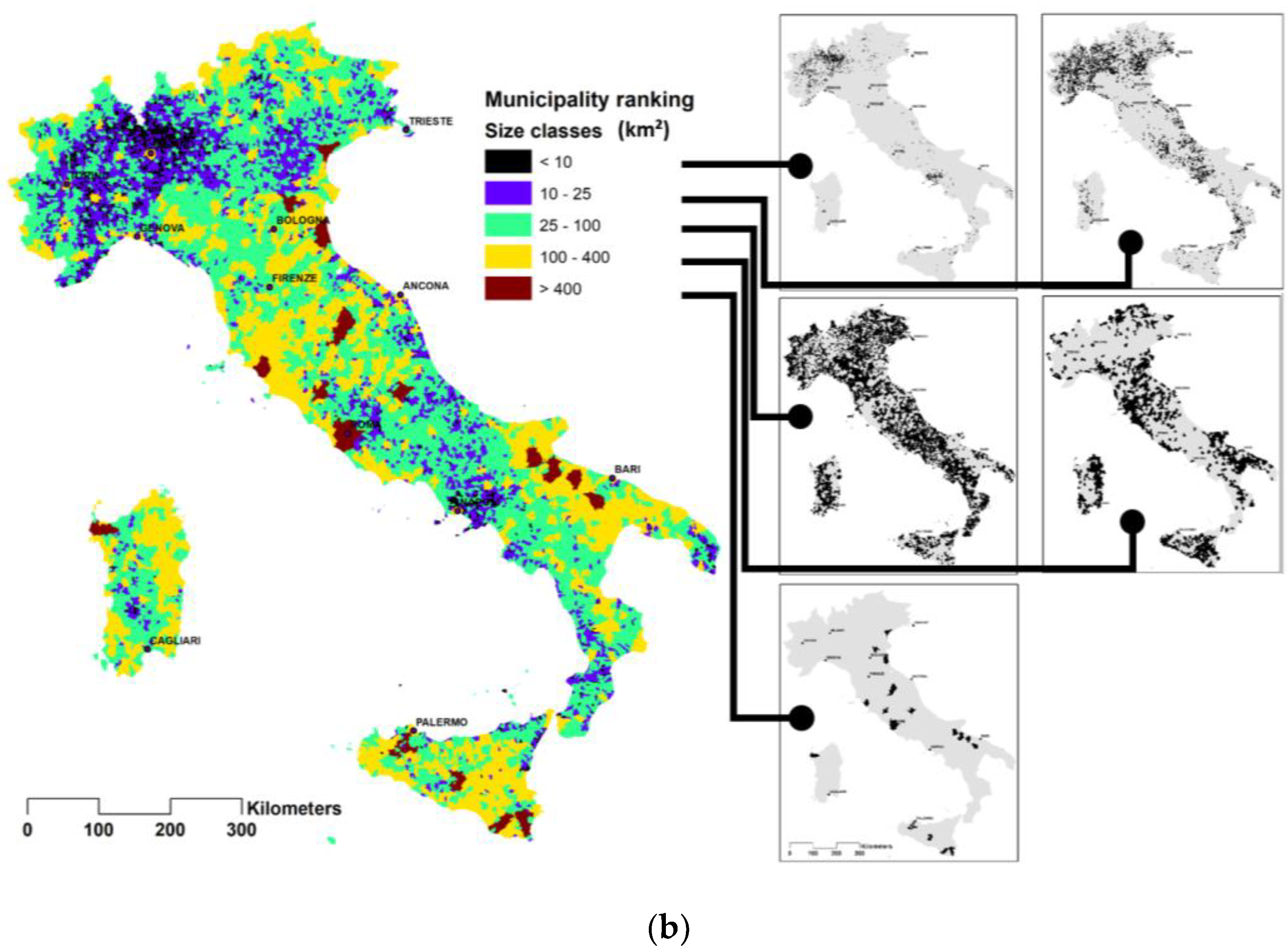
Figure 3.
Regional ranking of municipalities by size classes.

Figure 4.
Demographic variations between 1991–2018 in municipalities by size classes.

Figure 5.
Municipalities as urban parks. Some examples of municipal territories (in yellow) as large as urban green areas (top, Hyde Park in London; below, Central Park in New York City) with limited physical and spatial heterogeneity that however retain the utmost decision-making sovereignty over urban and infrastructure transformation.

Figure 6.
Updating of municipal town planning schemes in Italy (by INU, 2016).

Figure 7.
Ratio between twenty-year demographic dynamics (1991–2018) in municipalities in Umbria and the urbanized area growth rate in general town planning schemes (PRGs) in force.
Figure 7.
Ratio between twenty-year demographic dynamics (1991–2018) in municipalities in Umbria and the urbanized area growth rate in general town planning schemes (PRGs) in force.

Figure 8.
The data shown are the same as in Figure 7 but for the region of Lombardy. In the large plot, only the approximately 1000 municipalities with an urbanization density below 25% were considered. The three plots at the top show the data for the three classes of municipalities ranging in size between 10 and 100 km2.

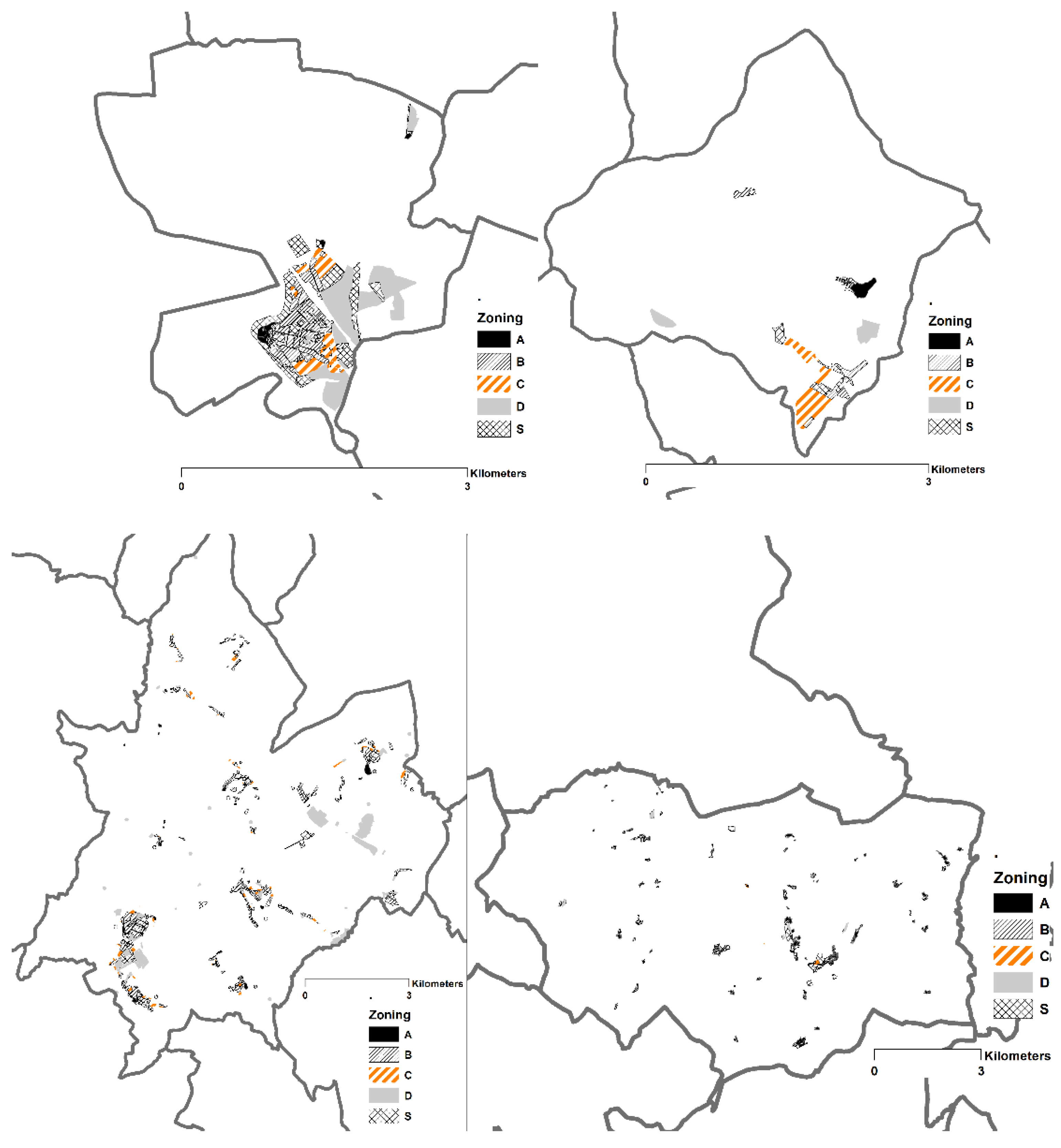
Figure 9.
Different examples of plans in Umbria: top, choice of compact settlements and below, significant territorial dispersion. Zone breakdown with legend standardized during regional mosaicking (A—historical zones, B—completion residential zones, C—Residential expansion, D—industrial/craftwork expansion, S—Public Utilities).

Figure 10.
Examples of original legends taken from Italian general town planning schemes with evident differences in definitions and categories used.
Figure 10.
Examples of original legends taken from Italian general town planning schemes with evident differences in definitions and categories used.


Table 1.
Data on the selected size classes of Italian municipalities.
| REGION | Municipality Mean Area (km²) | Municipality Area < 10 km² | Municipality Area between 10 and 25 km² | Municipality Area between 25 and 100 km² | Municipality Area between 100 and 400 km² | Municipality Area > 400 km² | ||||||||||||||||||||
|---|---|---|---|---|---|---|---|---|---|---|---|---|---|---|---|---|---|---|---|---|---|---|---|---|---|---|
| N. Municipalities | Urban Area 2000 (km²) | Urban Density 2000 | Inhabitants 2011 | Municipality Area (km²) | N. Municipalities | Urban Area 2000 (km²) | Urban Density 2000 | Inhabitants 2011 | Municipality Area (km²) | N. Municipalities | Urban Area 2000 (km²) | Urban Density 2000 | Inhabitants 2011 | Municipality Area (km²) | N. Municipalities | Urban Area 2000 (km²) | Urban Density 2000 | Inhabitants 2011 | Municipality Area (km²) | N. Municipalities | Urban Area 2000 (km²) | Urban Density 2000 | Inhabitants 2011 | Municipality Area (km²) | ||
| Lombardy | 15.74 | 721 | 1014.07 | 0.25 | 2898207 | 4111.88 | 564 | 1208.37 | 0.14 | 3179646 | 8781.46 | 219 | 962.14 | 0.10 | 2332425 | 9221.91 | 12 | 175.18 | 0.10 | 1293873 | 1747.85 | |||||
| Piedmont | 21.21 | 401 | 289.10 | 0.11 | 396122 | 2567.69 | 502 | 805.41 | 0.10 | 1212313 | 7875.85 | 274 | 877.17 | 0.07 | 1493492 | 12242.53 | 20 | 272.41 | 0.10 | 1262291 | 2700.63 | |||||
| Campania | 24.86 | 161 | 205.61 | 0.22 | 1404336 | 949.79 | 193 | 253.11 | 0.08 | 1454608 | 3272.93 | 184 | 405.88 | 0.05 | 1740093 | 7918.76 | 12 | 151.83 | 0.10 | 1167773 | 1529.11 | |||||
| Liguria | 23.15 | 58 | 34.30 | 0.09 | 128421 | 378.25 | 104 | 90.83 | 0.05 | 311785 | 1669.02 | 67 | 111.67 | 0.04 | 526518 | 2685.21 | 5 | 71.77 | 0.10 | 604482 | 683.65 | |||||
| Sicily | 66.24 | 51 | 53.17 | 0.16 | 294514 | 332.41 | 85 | 127.49 | 0.09 | 470697 | 1413.27 | 179 | 381.50 | 0.04 | 1484816 | 9142.29 | 71 | 629.47 | 0.05 | 2559650 | 12992.98 | 1 | 80.65 | 0.04 | 193227 | 1951.07 |
| Veneto | 31.96 | 42 | 59.40 | 0.18 | 130612 | 327.95 | 290 | 770.48 | 0.15 | 1641377 | 5077.70 | 223 | 1048.68 | 0.11 | 2297030 | 9764.45 | 18 | 186.36 | 0.07 | 525523 | 2758.80 | 1 | 68.91 | 0.17 | 261362 | 415.89 |
| Trentino A.A. | 46.59 | 41 | 14.25 | 0.06 | 41827 | 246.44 | 81 | 42.22 | 0.03 | 140753 | 1361.02 | 136 | 171.81 | 0.03 | 613786 | 6775.65 | 34 | 67.51 | 0.01 | 233109 | 5221.60 | |||||
| Calabria | 37.58 | 38 | 28.42 | 0.10 | 68133 | 272.56 | 144 | 164.08 | 0.06 | 334594 | 2599.01 | 202 | 390.82 | 0.04 | 935841 | 9101.05 | 21 | 221.44 | 0.07 | 620482 | 3249.01 | |||||
| Lazio | 45.59 | 27 | 7.65 | 0.04 | 33516 | 207.21 | 139 | 128.06 | 0.05 | 538106 | 2410.64 | 179 | 478.49 | 0.06 | 1525193 | 8270.86 | 31 | 291.96 | 0.06 | 725687 | 4649.40 | 1 | 19.55 | 0.05 | 63209 | 406.23 |
| Puglia | 75.74 | 26 | 34.10 | 0.17 | 89904 | 200.37 | 59 | 148.17 | 0.15 | 413465 | 1021.03 | 112 | 387.73 | 0.07 | 1133545 | 5743.31 | 57 | 642.13 | 0.06 | 2042382 | 10638.37 | 2 | 82.84 | 0.04 | 373270 | 1937.43 |
| Abruzzo | 35.51 | 24 | 10.67 | 0.06 | 39381 | 174.65 | 118 | 86.55 | 0.04 | 309521 | 2063.84 | 154 | 212.88 | 0.03 | 777420 | 7152.62 | 8 | 33.40 | 0.03 | 114023 | 966.48 | 1 | 23.84 | 0.05 | 66964 | 473.91 |
| Sardinia | 63.93 | 22 | 7.63 | 0.05 | 28106 | 147.29 | 78 | 44.61 | 0.03 | 79747 | 1364.87 | 206 | 390.99 | 0.04 | 865338 | 10829.54 | 70 | 298.72 | 0.03 | 542389 | 11211.05 | 1 | 37.31 | 0.07 | 123782 | 547.03 |
| Marche | 41.05 | 18 | 12.99 | 0.10 | 48448 | 133.41 | 94 | 106.87 | 0.07 | 332920 | 1589.66 | 95 | 197.67 | 0.04 | 554206 | 4562.63 | 22 | 180.20 | 0.06 | 605745 | 3115.48 | |||||
| Friuli V.G, | 36.52 | 15 | 15.56 | 0.16 | 24671 | 95.37 | 81 | 177.99 | 0.13 | 278205 | 1405.86 | 110 | 476.64 | 0.10 | 888729 | 5008.49 | 11 | 27.30 | 0.02 | 28686 | 1414.49 | |||||
| Valle d’Aosta | 44.07 | 8 | 4.16 | 0.07 | 9411 | 60.45 | 20 | 14.36 | 0.04 | 55860 | 342.85 | 38 | 22.33 | 0.01 | 51854 | 1669.90 | 8 | 6.24 | 0.01 | 9169 | 1187.66 | |||||
| Emilia Romagna | 67.83 | 7 | 13.75 | 0.25 | 41580 | 54.93 | 41 | 149.52 | 0.18 | 341923 | 845.46 | 225 | 979.26 | 0.08 | 1645440 | 11816.40 | 56 | 783.79 | 0.09 | 2026907 | 8676.46 | 2 | 148.96 | 0.14 | 286285 | 1058.95 |
| Tuscany | 83.89 | 5 | 12.56 | 0.35 | 29401 | 35.84 | 31 | 71.69 | 0.12 | 226263 | 584.74 | 162 | 667.18 | 0.07 | 1812949 | 9576.17 | 75 | 575.14 | 0.05 | 1524959 | 12316.30 | 1 | 36.03 | 0.08 | 78630 | 473.53 |
| Molise | 32.80 | 2 | 0.18 | 0.02 | 286 | 11.40 | 55 | 20.03 | 0.02 | 52242 | 999.95 | 77 | 89.48 | 0.03 | 250886 | 3247.49 | 2 | 3.27 | 0.02 | 10246 | 201.60 | |||||
| Umbria | 92.00 | 12 | 8.21 | 0.04 | 21069 | 207.16 | 58 | 90.28 | 0.03 | 220353 | 3191.33 | 20 | 146.30 | 0.04 | 447965 | 4090.35 | 1 | 56.38 | 0.06 | 194881 | 975.38 | |||||
| Basilicata | 76.89 | 12 | 3.98 | 0.02 | 12537 | 236.83 | 92 | 85.44 | 0.02 | 263879 | 5383.06 | 27 | 89.73 | 0.02 | 301620 | 4453.21 | ||||||||||
| Total and mean | 1667 | 1817.57 | 0.18 | 5706876 | 10307.88 | 2703 | 4422.05 | 0.10 | 11407631 | 45123.17 | 2992 | 8428.04 | 0.06 | 21413793 | 143304 | 580 | 4854.14 | 0.05 | 16646961 | 93804.48 | 11 | 554.48 | 0.07 | 1641610 | 8239.41 | |
© 2019 by the authors. Licensee MDPI, Basel, Switzerland. This article is an open access article distributed under the terms and conditions of the Creative Commons Attribution (CC BY) license (http://creativecommons.org/licenses/by/4.0/).
Share and Cite
MDPI and ACS Style
Romano, B.; Zullo, F.; Fiorini, L.; Marucci, A. Molecular No Smart-Planning in Italy: 8000 Municipalities in Action throughout the Country. Sustainability 2019, 11, 6467. https://0-doi-org.brum.beds.ac.uk/10.3390/su11226467
AMA Style
Romano B, Zullo F, Fiorini L, Marucci A. Molecular No Smart-Planning in Italy: 8000 Municipalities in Action throughout the Country. Sustainability. 2019; 11(22):6467. https://0-doi-org.brum.beds.ac.uk/10.3390/su11226467
Chicago/Turabian StyleRomano, Bernardino, Francesco Zullo, Lorena Fiorini, and Alessandro Marucci. 2019. "Molecular No Smart-Planning in Italy: 8000 Municipalities in Action throughout the Country" Sustainability 11, no. 22: 6467. https://0-doi-org.brum.beds.ac.uk/10.3390/su11226467
Note that from the first issue of 2016, this journal uses article numbers instead of page numbers. See further details here.