Article

Samothraki in Transition: A Report on a Real-World Lab to Promote the Sustainability of a Greek Island

1
Department for Social Sciences, University for Natural Resources and Life Sciences, A1070 Vienna, Austria
2
Department of Forest Inventory, Austrian Research Centre for Forests, A1131 Vienna, Austria
3
Institute of Marine Biological Resources & Inland Water, Hellenic Centre for Marine Research, Anavyssos, 19013 Attica, Greece
*
Author to whom correspondence should be addressed.
Sustainability 2020, 12(5), 1932; https://0-doi-org.brum.beds.ac.uk/10.3390/su12051932
Submission received: 12 December 2019 / Revised: 23 February 2020 / Accepted: 25 February 2020 / Published: 3 March 2020
(This article belongs to the Special Issue The Metabolism of Islands)

Abstract

:
This is a case study on a small mountainous island in the Aegean Sea with the policy goal of preparing it to become member of UNESCO’s World Network of Biosphere Reserves. While the local community opted for such an identity very early on, there are a number of obstacles to be overcome. The multidisciplinary research is based upon a sociometabolic approach and focuses on two issues: The transformation of agriculture, mainly herding of sheep and goats, and the shift to tourism. The degradation of the landscape caused by extensive roaming of goats and sheep constitute one of the major sustainability challenges of the island. We analyze farmers’ opportunities and describe new initiatives to get out of this deadlock. The impacts of the transition to tourism are addressed from an infrastructural perspective: A shift from traditional stone buildings to bricks and concrete, the establishment of new roads and ports, and the challenges to water supply and wastewater removal, also with reference to the quality and amounts of wastes generated that need to be dealt with. The island has so far escaped mass tourism and attracts mainly eco-tourists who value its remoteness and wilderness. We discuss how to serve this clientele best in the future, and increase local job opportunities and income while maintaining environmental quality. Finally, we reflect upon emerging new forms of local collaboration and the impact of our research efforts on a sustainability transition that might be on its way.

1. Introduction

The small (178km2) Greek island Samothraki (“Σαμοθράκη”) in the Northern Aegean Sea (Figure 1) finds itself in a situation of transition between being dominated by traditional agriculture (mainly herding of small ruminants) and tourism. The island hosts a unique ecological diversity, mainly because of its rich water resources and its heterogeneous landscape. Along the island’s stream courses and around the natural crystal-clear waterfalls and pools abound old oriental plane forests, while pristine old growth oak populations still persist at the hills of the central Saos-massif (1611m) [1,2].
Samothraki has been inhabited since prehistoric times and the fabric of the present society is still shaped by its history (www.sites.google.com/view/samothraki/history, accessed on December 2019). The most celebrated part of this history is represented by the remains of the “Sanctuary of the Great Gods”, a site of important Hellenic and Pre-Hellenic religious ceremonies. There, the Samothrakian or “Kavirian” Mysteries [4] took place, enigmatic rites open to both slaves and free people, even children. Herodotus and Pythagoras, for example, have taken part in them. In the fourth century BC, Philip II from Macedonia occupied the island; he is said to have met his wife on the Saos mountain, to later become father of Alexander the Great. During the Roman imperial period, Samothraki became an international religious center where pilgrims flocked in from all over the Roman world. The Bible records that Apostle Paul, in the first century CE, sailed on a missionary journey to Samothraki (www.sites.google.com/view/samothraki/history, accessed on December 2019). After a phase of Byzantine and then Genoan rule, Samothraki was conquered by the Ottoman Empire. An insurrection during the Greek War of Independence (1821–1831) led to a massacre of local population, in response to their refusal to pay taxes. Following the Balkan Wars, the island came under Greek rule in 1913. In the 1950s and 1960s, local poverty drove out a large number of men and families seeking work in the German automobile industry (In the Stuttgart area, there still exists a large and active cultural association of Samothrakians, many of whom are also entitled to vote on the island in local elections [5].) (Figure 2). They brought home money as well as knowledge of the language and the German industrial culture. During the time of military dictatorship in Greece (1967–1974), Samothraki was a place of exile for political dissidents. Thus, the history of this island has been marked by singular cultural and political features, and repeated population shifts.
In the decades after World War I, the local population had been growing to a peak of 4200 people. It then strongly declined and increased again with beginning tourism in the early 1980s (Figure 2).
Socioeconomically, the resident population gradually shifted from the primary sector towards the tertiary sector (Figure 3). Currently, there is a large group of poorly educated (sometimes illiterate), predominantly elderly farmers and a few fishermen leading a traditional lifestyle with little contact to outsiders. The secondary sector represents only a small and lately decreasing fraction of the island’s economic activity. There is one olive press, a dairy, a small winery, a beer brewery, and several bakeries, as well as some construction and mining activity. There also used to be a municipal wheat mill. In contrast, the tertiary sector has grown substantially during the last decades and now employs 60% of the island’s workforce. This better educated and more informed part of the population is working mostly in the service sector, tourism, and administration.
To a visitor in the early 2000s, Samothraki appeared as a place of overwhelming archaic, largely untouched, natural and cultural beauty, but also endangered. Scientists had already been engaged in recording the island’s aquatic quality and aquatic/terrestrial biodiversity, and found it highly impressive but under threat, although the majority of stream basins illustrate reference ecological conditions [1,6]. How could further research contribute to secure the unique natural qualities of this island? This would presuppose to create a vision and an identity for the community on this island that would frame the local conditions not as “backwardness”, poverty, and lack of modernity to be overcome, but as a worthy heritage and asset to be developed in a targeted way. It could only be successful if the local population would identify and be able to anticipate clear benefits from such a vision, benefits that would outweigh negative trade-offs. The concept that seemed best attuned to pursuing a pathway of both nature conservation and socio-economic benefits through sustainable social use of ecosystems appeared to be UNESCO’s Biosphere Reserve concept [7]. (Biosphere Reserves are areas that encompass valuable ecosystems and social communities that wish to combine the conservation of ecosystems with their sustainable use. They are nominated by national governments and remain under sovereign jurisdiction of the states where they are located, but become internationally recognized by UNESCO. Biosphere reserves form a World Network under the protection of UNESCO. Within this network, exchange of information, experience and personnel are facilitated. At present, there are about 700 biosphere reserves in over 120 countries (See: http://www.unesco.org/new/en/natural-sciences/environment/ecological-sciences/biosphere-reserves/)). This idea built upon the fact that over three-quarters of the island’s surface had been already designated as a Natura 2000 conservation area. Our team started a first research effort in this direction in 2007 to find answers to the following questions: Does the island of Samothraki provide adequate natural, social, and economic opportunities for a pathway of nature conservation and sustainable development as envisioned in the UNESCO Biosphere Reserve concept? Is the vision of becoming a Biosphere Reserve attractive to local (and regional) stakeholders? Does it offer containment and an identity that is welcome and promising? These questions were dealt with a literature and data review, and a representative survey (N=1511) of residents and tourists [8] leading to positive conclusions: The island’s landscape and biodiversity proved to be quite exceptional and highly worthy of protection; second, the local population, and even more so the tourists, gave support to a conservationist rather than a modern industrial developmental course. The outcome was a unanimous decision of the local municipal council in favour of an application to UNESCO. Scientists from the Institute of Social Ecology from Vienna helped to prepare the application form, and it was formally submitted as signed by the Mayor and other responsible Greek authorities in 2013 [9]. Unfortunately, though, it turned out that the Greek state had not yet fulfilled the legal and managerial preconditions associated with Natura 2000; thus, the application was deferred by UNESCO on the grounds of insufficient legal protection of the core conservation areas. This backlash made clear that it would take a longer breath, a more systemic perspective in research, as well as stakeholder mobilization and the building of policy alliances [8]. In other terms, we were heading for a “real world lab” to achieve a sustainable pathway for Samothraki [10,11].

2. Heuristics and Methods
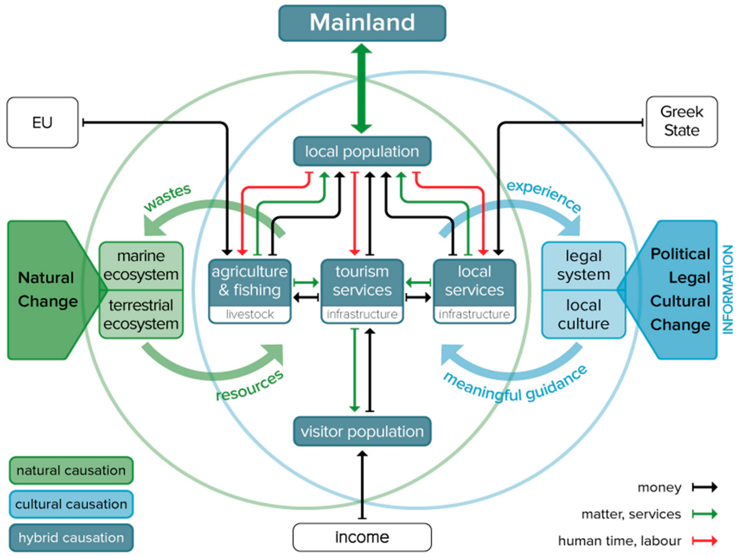
In order to be able to influence development dynamics, it seems appropriate to look upon islands as complex socio-ecological systems. In island studies, this perspective is not so common [12,13,14]: Rather, there is a focus on particular problems such as food security [15], migration [16], or overgrazing [17]. Guiding local sustainable development means to understand the conditions under which socio-economic activities can support the quality of life and the income of the islanders while sustaining (or even improving) the quality and resilience of the natural environment. Such a comprehensive research question can best be addressed by focusing on the exchange relations between the respective socio-economic sectors and the local environment with the help of a heuristic sociometabolic model [18,19] as outlined in Figure 4, specified for the case at hand.
When critical stocks cannot be reproduced, the system might ‘collapse’ [21,22]. Briefly said, a balanced sustainable development implies not to increase socio-economic stocks excessively, using natural resources carefully and efficiently, creating effective synergies between the sectors of the economy, and using commons with fairness and responsibility [18,23]. Across the years of research, this model served as a mind map for what matters for the sustainability of the island, and guided the selection of variables to be measured, the interrelations to be analyzed, and the attention for critical thresholds. In the core area of the model figures the human population (both residents and visitors) and their involvement in the three socioeconomic sectors: Agriculture and fishing, tourism services, and local public services (administration, schools, medical, care, and technical services). The sectors control certain biophysical infrastructures (animal livestock, built infrastructure, technical infrastructures). They draw on certain natural resources and generate wastes and emissions. They require human labor power and provide economic benefits. All these processes are subject to cultural and legal guidance, which they in turn influence across time.
Beyond this, such an island system is of course strongly linked to the outside world: Economically, to the Greek state, the European Union (Common Agricultural Policy, EU-CAP in brief, subsidies), and to the income the tourists earn somewhere else and spend on the island. Politically, legally, and culturally, it depends on the overall situation in Greece and beyond, and its natural conditions depend on broader environmental change (such as global warming). All these interrelations matter for finding a sustainable course. Across the years, the research team sought to operationalize quantitatively all stocks and flows shown in Figure 4. Beyond this, it documented their environmental impacts, and supported local stakeholders in finding solutions (responses). For a better understanding of this multi-method approach, Table 1 provides an overview structured according to the more conventional DPSIR—drivers, pressures, states, impacts, responses—framework [24].
The research process across more than a decade built upon yearly summer schools, each organized in collaboration between universities, research institutions, local and national authorities, NGOs, and UNESCO branches, with about 150 students altogether, from more than 20 countries and 40 universities [7,20,25,26,27]. The summer schools were designed in such a way that in each of them—depending on the scientific background and the research interests of the respective institutions and students participating—addressed certain research tasks contributing to the overall research question and helped to achieve maximum synergistic effects between learning, research, and addressing policy goals for local development. At the same time, they showed our continuous presence on the island to numerous locals, members of the municipality, and the regional administration. Part of our research also involved local so-called citizen scientists in ongoing explorations, thus feeding back our findings to stakeholders and the island’s public. A small producer visualized this research process across several years in the film “Wings of Samothraki” in English and Greek. (www.sustainable-samothraki.net/activity/wings-of-samothraki/, accessed on December 2019).
This article attempts a synoptic view of the findings accumulated so far. The results presented are structured according to the two core sectors of the island’s economy, agriculture and tourism, their development dynamics, and their environmental impacts. In the discussion, we place these findings in a broader perspective on the island’s chances of a comprehensive sustainable course, and the role of scientific research in its support.

3. Results

The narrative of our results follows the interlinkages as outlined in the sociometabolic model [18,19] in Figure 4. We describe the stocks of the terrestrial ecosystem and their dynamics. We do not quantify these stocks, as by NPP for example, like in [32], but describe them qualitatively as landcover and forest. We build our analysis on data published by members of our team on the quantification of stocks of the core socioeconomic sectors (as livestock [33] and built infrastructures [34]), the natural resources required by these stocks for their reproduction/maintenance, and the impacts of this resource use on natural stocks. For the built infrastructure, we also discuss the (pending) issue of future waste flows, i.e., backflows from society to the ecosystems. We relate these processes to the size (stocks) of the resident and visitor populations, and describe key socioeconomic flows required for their reproduction (such as income), as well as the origin of these flows from EU-CAP subsidies, visitor expenditures, and the Greek state, following Figure 4 (black arrows). With regard to the “cultural flows” (as pictured in blue in Figure 4), the reader is referred to the discussion section that draws on our findings from qualitative social research as described in Table 1 among the drivers and responses according to the DPSIR logic.

3.1. The Terrestrial Ecosystem and the Agricultural Sector (Livestock Herding)

Grazing is the dominant land use on the island. More than half of the total area is unfenced rangeland [29], used for spatially extensive but quantitatively intensive livestock breeding. As a result, Mediterranean macchia, different types of phrygana, bracken, and other vegetation formations (largely caused by grazing) dominate large areas of the island [1] “Natural vegetation on Samothraki occurs only in areas inaccessible to sheep and goats, e.g., sheer rock and steep ravines. In general, the natural plant communities are at various levels of degradation due to heavy grazing” [1] (pp. 46–47).
During the second half of the past century, many Greek islands passed through substantial land use transitions, followed by land cover changes that have often led to various degradation processes (e.g.) [17,39]. In the Mediterranean Basin, intense grazing is a widespread phenomenon that can trigger severe soil erosion. Today it is clear that Samothraki’s grazing system has also decoupled from its natural basis: A much too high number of undernourished and underutilized animals exploit and degrade pastures, thus magnifying natural soil erosion, and endangering the entire social-ecological equilibrium of the island [32]. This was lucidly demonstrated by a major weather event in September 2017 that triggered several landslides, demolished buildings, and covered large parts of the main town with rocks and debris. (https://watchers.news/2017/09/28/samothraki-flood-greece/, accessed on December 2019).
Samothraki is characterized by a diverse land cover (LC), typical for semi-natural Mediterranean landscapes (Figure 5 and Figure 6). Only 6.5% of the total area is used as cropland (and the crops harvested there are mainly used for animal feed). Semi-open grassland (27.8%), with only few trees persisting, is the most common LC-type. It is evenly distributed but mainly present as a transition zone from thick shrubberies to areas covered by open grasses, forming a vegetal belt on medium altitudes. Shrubland (20.1%), primarily dense matorral and garrigue, occurs all over the island. In the southern part, this includes olive plantations and pseudo-macchia. Woodland and macchia (13.6%) dominate on the northern and eastern slopes. Riparian woodland (Platanus orientalis) stretches along perennial streams and intermittent creeks and extends up to the stream mouths, a unique characteristic considering Greek islands. Open landscapes (scattered grass, 13.3%) appear almost exclusively in mountainous areas. Finally, 6% of Samothraki show no land cover (bare soil).
Two LC-types deserve special consideration. Both can be linked to specific former land use patterns: Bush encroachment and weed invasion [17,40]. Bracken fields (Pteridium aquilium) appear only in the island’s more humid northeastern half. Most of it occurs in remote areas, around woodland borders, and on high altitudes above the tree line (Figure 7b). Lowland pastures are also infested by closed cover patches of this undesired weed (bracken is undesired because livestock does not feed on it, which is the reason that it becomes so dominant). Sarcopoterium spinosum, which characterizes the typical Aegean phrygana, occurs in low to medium altitudes but not on mountainous rocky terrains. It appears mainly around the lower smooth shaped foothills of the pasture farming-based villages.
In higher altitudes on the northern and eastern slopes of mount Saos, there are pristine woodlands (Quercus petraea) that drew our special attention for two reasons: First, because they allow us to reconstruct a longer term history of land-use practices, and second, because their survival is essential for the stabilization of soil and the containment of erosion [37]. A detailed investigation of two remaining forest areas [2] came to the conclusion that there has been a long history of intensive silvo-pastoral land use, particularly in the 18th and early 19th century. This was apparently interrupted by the massacre by Ottoman troops in 1821 that severely decimated the local population and livestock and thus allowed for several decades of forest regrowth. In the second half of the 19th century, though, massive forest clearing occurred for the production of charcoal (an export product of the island at the time), and silvo-pastoral practices were resumed. According to this analysis, 86% of the forests are currently in a critical state, classified by several criteria as of high regeneration priority; the youngest tree found was of the cambial age of 47 years (with an average cambial age of 151 years across the two areas investigated). The main reason behind the lack of forest regrowth identified by pasture tracks and feces count was animal grazing. This comes as no surprise if one looks at the development of animal numbers on the island (Figure 8).
According to the European compliance standards of 1.4 head/ha, the island could sustain about 23,500 grazing animals [32], but this number had already been surpassed in the late 1960s, and in 2002, the small ruminants reached a peak with almost 70,000 animals. Interestingly, we then observe a sudden decline, particularly of the goat population, to about 45,000 animals, a number that is nevertheless still almost twice as much as the cross-compliance recommendation by the EU. How did this decline come about? Before we report on our search for an explanation, Figure 9 documents how this process reflects itself in land cover change, investigated on the basis of satellite imagery.
Figure 9 shows that a major part of Samothraki’s land cover had become up to 40% less “green” by the year 2002, as compared to reference year 1984 (the year of the first available satellite images), and then gradually recovered and stabilized at a level still markedly below the 1984 standard. This timeline corresponds very well to the development of animal numbers shown in Figure 8. In order to adequately interpret the drivers behind the positive LC-development of the recent years, one must scrutinize altered land management practices, or rather a shifted “style” of daily local husbandry. The latter is decisive for the pasture capacity of an area [41,42].
Samothraki’s grazing regime was strongly influenced by basic land use transitions at greater scales. In Greece, the last “traditional” subsistence-based forms of peasantry were finally dissolved by around 1945. This was followed by an era that secured fundamental (land use) rights [43] to single farmers—a system still in place in the background of current EU-CAP regulations. Since then, Greece encountered trajectories towards industrial agriculture, but at a much slower pace compared with the rest of Europe, and even less so in marginal mountainous and insular areas [44]. Initially, the local mode of livestock breeding expanded in animal numbers [45], accompanied by a steadily decreasing esteem of the local rangeland state [17]. Samothraki seems to have remained in an “in-between grazing management regime”. Key modernization projects remained unfulfilled. This concerns industrial processing and storing, land reclamation, increased access to markets, and the establishment of cooperatives [43]. On the one hand, hardly any traditional management (such as regularly burning weeds) is practiced, and on the other hand, Samothraki did not undergo profound modernization and industrialization processes. Human labor was substituted by energy inputs via improved physical infrastructures (e.g., roads to higher altitudes), fossil energy-based mobility (e.g., pick-ups and tractors), or through the import of external fodder, but hardly by any modern technologies of animal utilization and marketing, let alone efforts at organic farming. Reviewing Samothraki’s land use system in a broader historical context reveals that a dwindling income and few future prospects for the older farmers have resulted in the establishment of an effort-minimizing style of farming that harms the pastureland and does neither benefit the animals nor the farmers (Figure 10).
However, the question remains, why did livestock farmers on Samothraki respond to this situation by steadily increasing the size of their herds beyond feed availability? According to Figure 8, this process started in the early 1960s, accelerated in the 1980s, and virtually exploded in the 1990s. The most suitable explanation we can offer is agricultural subsidies, first from the Greek state and then from the European Union. Those subsidies aimed at compensating farmers for decreasing market prices by providing an extra income based on their production volumes, thus creating a strong incentive to raise animal numbers. As market prices for animal products declined, the share of subsidies in small farmers’ income increased, and thus their dependence on them (see Figure 10). The EU-CAP subsidy policy changed in 2003, but there was a significant delay until those changes were implemented by Greek authorities, and even more delay until farmers could really comprehend on what grounds they do receive the subsidies estimate [29,46,47].
Thus, in effect, livestock farmers still live on a very low average income of 5000€ per year, half of it from subsidies; we do not expect the income of the other farmers to be any higher. The total number of farmers has been strongly declining in the past decade (Figure 3)—but death or retirement of farmers does not necessarily diminish their “grazing rights” (as defined by the regional agricultural administration), nor the access to subsidies.
Then why did animal (in particular, goat) numbers drop so suddenly after 2002, by well over a third within a few years? The most suitable answer we came up with on the basis of dozens of farmers’ interviews, observation accounts, and modelling efforts, is the following: A reduced amount of available food on pastures (Figure 9) and insufficient additional feed from farmers, in the absence of substantially increased slaughtering rates, caused animals to die prematurely, and to have their reproduction rates severely diminished. What we witness here seems to be a real, natural kickback, resulting in a “tipping point” of animal numbers.
Still, current livestock numbers exceed the grazing capacity of the land [32], and the abandonment of labor-intensive management practices (e.g. [17,48]) determines to a large extent the composition of land cover. Aegean phrygana and bracken could spread on pastureland. Thus, grazing pressure intensifies on rangelands not yet affected by such bush or weed encroachment (Figure 11) This, together with the lack of recovery of heavily degraded areas, suggests that the island is severely overgrazed, not just heavily grazed. In this context, “overgrazed” refers to grazing that degrades the standing biomass in a way that weakens the overall productivity basis of rangelands in the long run [3]. Although vegetation increases again (Figure 9), this does not necessarily imply a recovery of vegetation suitable as animal feed and an increase in pasture productivity.
At present, the main limiting factors for achieving a sufficient grazing capacity are accelerating bush encroachment and the loss of topsoil. Current land use patterns indicate large missing potentials and Samothraki’s livestock production system finds itself in a deadlock [36]. Grazing pressure is still too high to allow for regaining sufficient vegetation productivity. One of the key measures in our project was experimental: To offer farmers a seed mixture developed in Portugal for “sown biodiverse pastures” (SBP), with a high share of legumes, for free. We established a pilot project in collaboration with the University of Lisbon, its spin-off Terraprima (www.terraprima.pt/en, accessed on December 2019), and local farmers, in order to assess the effectiveness of Sown Biodiverse Pastures (SBP) on Samothraki. The SBP system is based on sowing up to 20 species/varieties of legumes and grasses that are self-maintained for at least 10 years, with all used species native to the island. The legumes, being ‘natural factories’ of nitrogen, minimize the need for synthetic fertilisers, increase the amount of carbon bound in biomass and are more resistant to grazing. After some skepticism, this was well received, and the experimental fields properly tended yielded between 20% and 50% higher productivity than neighboring fields [27]. The soil, therefore, is obviously not the key limiting factor for productivity, but rather poor practices and overgrazing.
Besides overgrazing, another factor limiting soil cover is naturally occurring erosion. This derives from tectonically deformed bedrock, steep slopes, and restricted groundwater aquifers creating flash floods. Recent research results [37] showed that soil loss under the present situation of animal grazing was 15.8 t/ha, with most vulnerable being an area extending from the center of the island to the adjacent steep headwater areas of its streams. The simulation of a non-grazing scenario resulted in a soil loss diminishing by 25%, indicating that overgrazing alone cannot explain the high erosion rates of the island. Possibly, the massive deforestation that took place during the last centuries degraded soil cover already before overgrazing became the overwhelming cause for soil erosion. Thus, soil loss prevention actions should not only target grazing management, but should be the subject of an integrated plan for natural vegetation regeneration, including reforestation to the greatest possible extent, as well as constructive practices, e.g., building of terraces, and the extension of Sown Biodiverse Permanent Pastures [37].
The devastating landslides in 2017 (https://watchers.news/2017/09/28/samothraki-flood-greece/, accessed on December 2019) emphasized the importance of an appropriate ground cover recovery. Samothraki’s socio-ecological future as a tourist destination and even more so as a UNESCO Biosphere Reserve will depend on improving this situation.

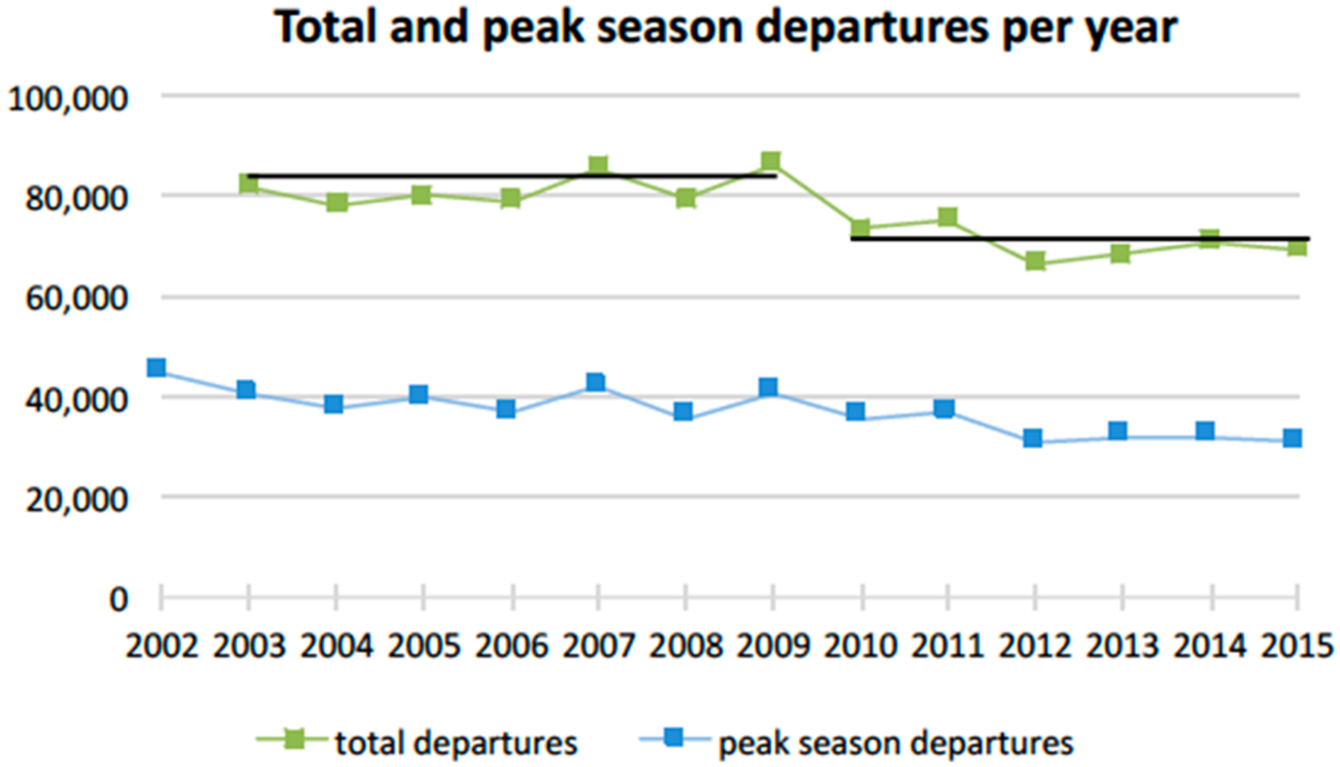
3.2. Tourism Dynamics and its Impacts on Infrastructure and Income

Samothraki’s infrastructural modernization essentially commenced in the 1960s with the establishment of an electricity network fed by local diesel generators (active until 2000, when an under-water cable connected the island to the central Greek grid), and an extension of the main port.
In the 1980s, after the end of the military dictatorship in Greece (1974) and its subsequent accession to the EEC, the road network was extended along the north coast, and a second smaller port was built (see Figure 1a port at Therma). This additional port was nourished by the hope for increased tourism, and attracting more prosperous tourists with their yachts. This hope was not fulfilled: The port construction instead proved to continuously attract tons of sand and gravel to fill the port basin [49], not allowing access for larger ships (Figure 12a).
In the 1980s, traditional stone buildings still dominated the architecture of houses (Figure 12b). By the early 1960s, a new building technology gradually set in, facilitated by the savings brought home by migrant workers returning from Germany, and by loans taken under the prospect of future profits from tourism: Brick and concrete buildings became the choice of the time. While traditional stone buildings in remote agricultural areas were mostly abandoned, construction of brick and concrete buildings, ports, and roads resulted in a two-fold increase of in-use stocks (Figure 13). Fortunately, authorities were wise enough to protect the scenic central town of the island, Chora, and largely preserve its traditional style of architecture up to now (www.sites.google.com/view/samothraki/history, accessed on December 2019). In the decades following, tourism and income development did not take off as steeply as had been expected and the Greek debt crisis after 2008 brought local construction activities more or less to a standstill [34].
While stocks-in-use had doubled, essential infrastructural functions are still not taken care of: Settlements are served by septic tanks, and only two (Chora and Lakoma with 653 and 317 inhabitants, respectively) partly afford sewage systems that discharge untreated water to adjacent streams, thus threatening their ecological integrity. According to its Operational Program (2014–2019), the Municipality of Samothraki plans the construction of a sewage system and a wastewater treatment plant for Kamariotissa as well as the replacement of the obsolete sewage system of Chora [50]. Freshwater supply to the settlements and the tourism establishments had not seen any major investments [36], despite the fact that demand in the summer months had soared. Fortunately, Samothraki is an island with significant freshwater resources (particularly in the north) and water quality is excellent [6]. However, as a result of unsustainable water management, some settlements and crops suffer from water scarcity during the summer period, and a number of streams face artificial desiccation with adverse ecological consequences [6]. Also, the island remains vulnerable since flood forecasting and respective abatement measures are missing. Currently, water management is carried out in old-fashioned, ad hoc, and, frequently, individualistic ways that are often inadequate to satisfy the needs, especially during extreme events, like floods and prolonged droughts [36]. Thus, while Samothraki does not suffer from water scarcity, like so many islands do, it is still confronted with several management challenges.
Over the last four decades, the demand for additional floor space for the growing tertiary sector, tourist establishments, supermarkets, storehouses, and other small businesses has led to a shift of the economic center of the island, Chora, to the port city of Kamariotissa. Since the 1960s, Kamariotissa underwent a threefold population increase (from 277 in 1961 to 940 inhabitants in 2001), while most of the other settlements on the island declined; e.g., the population of Chora, the island’s capital, dropped from 1555 to 698 during the same period [34].
The expansion of the built environment contributed to the welfare of the island community but left its mark on the landscape. Since local extraction of non-metallic minerals had been banned in 1991, all construction materials must be imported. The prices for these materials have been rising and the growing material stocks require increased maintenance. In the past, construction and demolition wastes were practically non-existent or re-used, but now, their large amounts lack legal deposition opportunities. Given new EU regulations, the shift to new building materials will constitute a major challenge in the future. This also applies to the roads. Due to the island’s steep terrain and erosion processes, asphalt roads wear down very quickly, while bridges and exposed stretches are regularly washed away by severe weather events and often require fortification by concrete walls [34]. The need to ship the necessary materials to the island (and wastes off the island) generates additional costs, not viable for the local municipality. A sustainable solution would require reducing the import of environmentally problematic construction materials, and utilizing more locally abundant resources, such as wool or straw for insulation purposes, and possibly even the carved stone material from abandoned houses that is plentifully available.
The island’s infrastructure serves the permanent residents, whose number, after peaking around 4200 in 1951, has stabilized since the 1980s at about 2800 (Figure 2). It also serves an increasing number of temporary residents, such as owners of second homes, seasonal workers employed in the tourist sector, and tourists. We estimated the size and composition of these latter groups from surveys among the departing travelers on ferries, which are practically the only way to reach the island (Figure 14). With the help of monthly port statistics, and information on the length of stay and travel frequencies from our surveys, we estimated the size and composition of all groups. This information had so far been missing and will be particularly valuable for the future planning and managing of infrastructures and socio-metabolic requirements (e.g., food, water supply, and waste disposal). Thus, on top of the permanent residents, during the summer season, we estimate an additional 3000 secondary homeowners, and their numbers are rising (Table 2). Moreover, there are family visitors in the order of magnitude of 1800 and about 2000 seasonal workers. On top of this, the island receives about 22,000 tourists per season (Table 2). This means that during the summer months, with a strong peak from mid-July to mid-August, the island has to sustain a daily population of around 7000 people (2800 inhabitants plus 4300 visitors).
The overnight accommodations offered in hotels and private rooms exceed the demand by more than 40% [31]. The preferred option, chosen by over a third of the tourists, is camping, either at the municipal coastal forest camping grounds, or freely next to the rivers up the mountain. Tourist accommodation is mainly offered in small family-owned businesses. In this, Samothraki clearly differs from typical Mediterranean tourist destinations with big hotel complexes and energy-intensive accommodation infrastructure. It rather falls in the category of “vacation islands”. On vacation islands, pressures mainly stem from the impacts of permanent infrastructure for visitors and the environmental resources consumed [51]. There are virtually no organized mass tourism operators, apart from the occasional bus from the Greek mainland. One of the reasons behind this is the unpredictability of the ferry connection to the mainland, where one owner has a monopoly, changing the schedule by the week, not adjusting it to plane or bus timetables at the mainland port city.
When evaluating the sustainability of tourism on Samothraki, camping plays a big role. Campers spend only half as much money per week as tourists staying in hotels and private rooms. Nevertheless, their overall contribution to local income from tourism is about 40%, as campers generally stay for a longer period [Τable 2]. Moreover, campers walk and use public transportation more often. While less than 15% of people staying in hotels or private accommodations stated to have walked, biked, or used public transport, 31% of campers on the municipal camping grounds and 53% of all free campers did so. In addition, campers are more likely to return to the island. During the peak season of 2015, about 70% of all campers declared their certainty to come back to Samothraki, while among tourists staying in hotels or private accommodation, just 49% felt sure to come back. Therefore, people camping on Samothraki are more faithful and have lower infrastructural demands, while still contributing substantially to the island’s income (data analysis from visitor survey 2015, N=1471, and camper survey 2017, N=870).
Based on our estimates, tourism generates about 13 million€ annually, which account for almost half of the island’s income (Table 3). While in terms of economic activity in 2001, the primary sector—consisting of agriculture, livestock herding, and fishery—still dominated, in the following decade a massive social change occurred: Many farmers decided to retire (Figure 3), and the active population in the tertiary sector soared. This happened despite the fact that tourism, during this decade, has been stagnating (Figure 13). Note, however, that it is a common practice for many locals to maintain a diversified household economy, based to some degree on subsistence agriculture and some animals while seasonally utilizing tourism opportunities [52].
In effect, with reference to Figure 4, the tourism sector provides the island with an income needed to sustain the resident population, and it creates a challenge to local waste management; but, if infrastructure were wisely handled, much less of a challenge to the local ecosystem than the agricultural sector and livestock herding.

4. Discussion: On the Chances for a Sustainable Future of the Island, and the Role of Science to Support It

This transdisciplinary sociometabolic research was supposed to serve two distinct goals: One goal was to explore and reconstruct the systemic conditions and dynamics of how this local society interacts with the island’s natural environment (Figure 4), and where the risks and chances for sustainable outcomes lie. This was the scientific challenge to respond to with multiple methods. The other goal was to connect to existing motivations for finding a sustainable pathway, to strengthen them, and help local people to organize. This did require regular and effective local communication of scientific insights, but also a deeper understanding of local mindsets and habits. This was the transdisciplinary nature and the practical-political part of the task.
Our scientific findings, as reported in the previous section, demonstrate serious threats to a sustainable future of the island: Most prominently, a progressive loss of vegetation cover and dramatically increased erosion and exposure to extreme events, with impacts beyond the economic capacity of the local system. The ongoing ways of expanding built infrastructure are exposed to these risks and bear some ecological and economic risks of their own in terms of raw material acquisition and disposal.
So, what could a successful transition to sustainability look like? The island needs to escape from the deadlock of the dysfunctional traditional farming system that can hardly secure an income for the farmers but destroys the vegetation cover and the landscape. Yet, it is exactly the landscape that provides the core recreational and economic attractions for tourism. Even more of a challenge derives from a recent plan of an international industrial conglomerate, supported by the Greek national administration to establish an industrial wind park (39 windmills) on the top of Saos mountain, in the centre of the area destined for Natura 2000, to produce electricity for export. Such a wind park would be visible from far and completely disrupt the ecotouristically most attractive virgin mountain area, dry out headwater springs and streams and require, for the transport of infrastructure and hundreds of tons of concrete, a new road in very steep terrain up from the seaside to the mountain tops – thus creating a new source of major erosion [37]. The municipal council has unanimously opposed this plan, the regional authority too, but future is open.
There are some ongoing processes that point in this direction: Farmers are getting older and their overall numbers are diminishing younger farmers see their chances in collaboration and finding new ways. Still, market conditions for agricultural products are not very good, several legal regulations stand in the way of direct economic transactions between farmers and the local tourism industry, and traditional political clientelism stabilizes large livestock numbers. With insight spreading, new European CAP regulations ahead, and the urgency of effective nature conservation becoming ever more apparent to everyone and being publicly declared by an application to UNESCO, chances are that the deadlock can be overcome. Our intensive work with farmers (focus groups, individual interviews, and Sown Biodiverse Pastures experiments) may have contributed.
At the same time, experiences over the past decades have dampened hopes for big business in tourism (such as yachts and cruise ships landing, an airport, large hotels, and exclusive cottages for the rich) and prepared the way for more moderate (and more sustainable) expectations that will still allow for decent job opportunities in the service and secondary sector and cash in on the ecological and cultural treasures of the island. Outside of the peak season, the island offers a perfect infrastructural setting for conferences, summer schools, cultural events, mountaineering courses, and health treatments, and may also serve as an international sight for basic and applied environmental and social research. A key precondition, though, is an increased predictability and reliability of the ferry services, also in the pre- and post-season. Thus, there are good chances for maintaining local income without further increasing material stocks and flows for infrastructure.
For the secondary sector, a transition is maybe most urgent technically and socially. Maintenance and repair of existing infrastructure (water supply, roads, electric, and sanitary appliances in tourism establishments and private houses, installation and grid supervision of the many photovoltaic parks on the island) are dearly in demand of qualified labor. Several hundred secondary homeowners are there to welcome caretaking and off-season maintenance of their houses and gardens, and many of them could easily afford that. There is not even one certified mechanic on the island who would be entitled to do the annually required check-up for the cars of the inhabitants. Unfortunately, the Greek education system does not provide adequate learning opportunities for technical jobs and crafts; and thus, wage labor according to the welfare standards common in Europe (monthly pay, payed holidays, access to free or cheap health treatment, unemployment benefit, old age pension) exists practically only for the employees of the public sector, or of large companies. Thus, most of the economically active population on the island is “self-employed”, usually not formally qualified for the jobs they do, and in the field of crafts frequently figure as dayworkers [7], bearing all economic risks from day to day. Specialists, such as those setting up and maintaining the photovoltaic panels, are all employed by outside companies and brought over from outside.
Qualified wage labor, rather than self-employed family labor or “farm hands”, is one of the key features of modern society, spreading from the urban centers. This transition is particularly hard to make on islands. In other peripheral areas, commuting daily or weekly for one’s job to an urban center is very common, both in the phase of formally learning the skills required, and later in practice. For most islands, this is hardly possible: Distances are too long and connections too unreliable. Maybe a further transition to more IT work will make some of that easier—but unless differentiated and formalized education processes (taking place outside of islands, usually) secure qualifications for complex technical tasks properly, populations on islands will keep facing these challenges. Still, better education should be a pathway towards improving the living standards of the locals without further raising demands upon material and energy resources—possibly even lowering these demands.
Beyond such specific educational requirements that are not well met currently, a local sustainability transition makes high demands upon the ability of a local population to self-organize, to jointly engage in making changes happen [53]. Ways of mutual support must be established between the island’s core economic sectors, instead of mutual neglect, destruction, and contempt.
Traditional collaboration patterns in agrarian societies are strongly family centered and hierarchical, with little functional differentiation. You do something because the father tells you so—and not because you are particularly qualified for it. Extended beyond the core family context, this means that if I have the say, you get the job because you are my cousin’s cousin, not because you are particularly good at it—the well-known nepotism. In consequence, mutual trust between families and co-citizens is low, each decision is suspected to be in somebody’s particular interest, and not for a fair joint benefit. In effect, private (family) property is protected, while the commons tend to be overused. In such a culture, it is very difficult to have people collaborate for complex common goals; for this, one needs networks of like-minded individuals with various competencies who trust each other to be able to work together in functionally differentiated structures with flat hierarchies.
In this respect, in the course of our efforts to stimulate innovative solutions, we could distinguish two main groups of the resident population—we called it the difference between “locals” and “neo-locals”. They differ not only in age and educational background, but also in the type of collaboration they prefer and are able to organize with others (see below). “Locals” basically comply with the culture and collaboration patterns described above as traditional and have not spent much of their lives in other settings but the island. “Neo-locals”, even if their family roots are on Samothraki, have learned to function also in other settings, and more easily associate with like-minded others to get something done.
Maybe it is the rising share of “neo-locals” among the island population that facilitated, after several failed efforts in the past, the recent emergence of a number of bottom-up initiatives to organize partners for some joint interest. An olive farmers’ cooperative was founded and bought a new olive press that now allows its members to label the oil as “organic” and achieve a better price for it; a newly founded “social cooperative” took over one of the defunct municipality’s camping sites to everyone’s satisfaction; and maybe most importantly, a farmers’ association (after many failures in the more distant past) was formed under female leadership (!) that is supposed to organize joint feed ordering and joint sales of sheep and goat, thus achieving better prices and encouraging younger farmers to choose new strategies. Most closely tied to our research project and proceedings is the also newly founded association “Sustainable Samothraki” with about 50 members, devoted to the purpose of making the island more sustainable. The association established an international scientific advisory board (ISAB) from the members of our research team and recently published the policy recommendations of this board widely in English and Greek [54]. Thus, enhancing this ongoing cultural change is another avenue towards improving lives while lessening resource extraction and improving waste disposal. We believe that membership in and exchange with the community of UNESCO biosphere reserves, whenever the Greek government has created the legal conditions required, will support this cultural change.

5. Conclusions

So, finally, during the many years of research, repeated presence, and outreach on the island, activities in the sense of a “real world lab”, what did we actually achieve? One answer is relatively easy: We generated salient descriptions and, in some cases, even solid causal explanations of the social and ecological realities and made them bear on public awareness.
For example, one of the locally popular explanations for the obvious decrease of vegetation had been scapegoating the nuclear accident in Chernobyl (in 1986), and not the goats—quite an absurd theory, but widely believed. With another popular explanation we had more difficulties, and almost believed a wrong attribution ourselves: That the rapid increase in livestock numbers was mainly the fault of EU-CAP subsidies. It took us a while to dismantle this assumption and show that reasons were more complex and strongly linked to Greek national, regional, and local regulations (some of them quite at odds with EU-CAP). Another message we could probably get across was that climate change in the Mediterranean meant a higher incidence of extreme weather events and thus a higher risk of landslides, particularly in steep areas lacking vegetation. Reforestation and appropriate infrastructure would be needed to mitigate these risks. Our research probably also reinforced the lowering of expectations for growing tourist numbers and appreciating the income they achieve from campers.
We are less sure that the core insight from the socio-metabolic paradigm got across: Namely, that all material input into the economic process finally ends up as wastes to be dealt with, and that the benefits achieved with sales and purchases would one day need to be balanced by efforts and costs for waste management and removal. These days have already come—but are still poorly recognized.
The scientific descriptions and explanations may not have fully penetrated the minds of the inhabitants and created a dominant public awareness, but they have at least reached many entrepreneurs and the local intelligentsia, our core communication partners, and the public administration. In 2016, the Municipality of Samothraki decided on a “Strategic Plan” according to the following principles [50]: (1) Environmental protection and improvement of the quality of life, (2) strengthening social policy and education, culture, and sport services, (3) economic growth and employment, and (4) improving the administrative capacity of the municipality. This plan also acknowledges the necessity to attract “high quality, alternative tourism”. The guiding policy priorities for the Municipality of Samothraki (2016) include: Improving maritime transport and port infrastructure (extension of Kamariotissa port, creation of a marina at Therma); improving solid waste management, constructing waste water treatment plants; expanding, improving, and maintaining the water supply network; restoring the road network; improving health infrastructure; promoting high-quality agricultural and livestock products; and various other goals. How far these plans are related to our research activities and outreach is hard to say—but they reflect many of our policy intentions. The ambitions of the local government, though, are often not matched by higher levels of the Greek governance system, so the final establishment of the Natura 2000 areas in Greece has again been delayed, blocking the island’s pathway towards becoming accepted as a Biosphere Reserve by UNESCO—the initial policy goal of our research, and still a policy goal of the municipality.
Another answer extends beyond what to typically expect from science: Our work, and our regular presence, seem to have brought encouragement. They encouraged a number of people not to resign and settle with what was given, but to trust that something better could be achieved. They gained in ability to organize themselves, to raise funds, and to initiate processes. This refers particularly to the members of bottom-up initiatives, but it also applies to several members of the public administration (four different mayors, for example, to varying degrees), interested partners in the regional governments, and a number of local farmers and tourism entrepreneurs. Such an encouragement, if not followed by successes, can easily generate excessive demand upon the leaders, wear them out, and end up in resignation. Thus, it is important to keep up a certain momentum and secure at least a minimal flow of resources and fresh manpower, be it in the form of enthusiastic students who want to learn about the island every year.

Author Contributions

Conceptualization, M.F.-K., P.P.; methodology, M.F-K., M.L., D.N., N.S.; validation, M.F-K., N.S.; formal analysis, M.F.-K., M.L., D.N.,N.S.; investigation, M.F.-K., M.L., D.N., P.P., N.S.; M.F.-K., N.S.; data curation, D.N.; writing – original draft: M.F.-K., M.L., N.S.; writing – review and editing, M.F.-K., D.N., P.P., N.S.; visualization, M.L., D.N.; supervision, M.F.-K.; project administration, D.N.; funding aquisition, M.F.-K., P.P. All authors have read and agreed to the published version of the manuscript.

Funding

This research received external funding from the Austrian MAB-committee at the Austrian Academy of Sciences, contract UF2013 (SamoMAB) and the Austrian National Science Fund, grants number F15P27951-G27 (SUSAKI) and - F15TCS00022 CiSciSusaki).

Acknowledgments

The Alpen Adria University contributed to this research, within the master’s program on Social and Human Ecology, by supporting annual summer schools on the island 2012–2019; other supporters of these summer schools, in providing teaching and advice, have been the Hellenic Centre for Marine Research in Athens, in particular Anastasia Lampou, as well as Simron Singh from Waterloo University, Canada. We thank Tiago Domingos (University of Lissabon) for advising us on Biodiverse Sown Pastures and Terraprima (Marjan Jongen, Antonio Martelo) for performing the experiments. Georg Gratzer and Carina Heiling (University of Natural Resources and Life Sciences, Vienna) designed and performed the dendrological part of our study. Much of the diversity and quality of the research is due to the efforts of many highly engaged students and local “citizen scientists” (see various entries at www://sustainable-samothraki.net). Throughout the process, we have been supported by the consecutive Mayors Petroudas, Chanos, Vitsas and Galatoumos, and members of the local administration. Finally, we need to thank numerous local initiatives for their trust and practical help, in particular the president and vice president of the association Sustainable Samothraki, founded in 2016, Carlota Marañon and Giorgos Maskalidis.

Conflicts of Interest

The authors declare no conflict of interest.

References

  1. Biel, B.; Tan, K. Flora of Samothraki; Goulandris Natural History Museum: Athens, Greece, 2014. [Google Scholar]
  2. Heiling, C. Spuren Historischer Ressourcennutzung anhand Dendrologischer Befunde: Eichenwälder auf der Insel Samothraki. Master’s Thesis, University of Natural Resources and Life Sciences Vienna, Vienna, Austria, 2018. [Google Scholar]
  3. Löw, M. Spatial Patterns of Land Cover Dynamics on Samothraki Island: Applying Remote Sensing on Complex Mediterranean Pastures. Master’s Thesis, Alpen Adria University, Vienna, Austria, 2017. [Google Scholar]
  4. Bremmer, J.N. Initiation into the Mysteries of the Ancient World. In Münchner Vorlesungen zu antiken Welten; De Gruyter: Berlin, Germany, 2014; Volume 1. [Google Scholar]
  5. Kolodny, E. Samothrace sur Neckar. Des. Migrants grecs dans l’agglomeration de Stuttgard; Institute de Recherches Mediterraneennes: Aix-en-Provence, France, 1982. [Google Scholar]
  6. Skoulikidis, N.; Lampou, A.; Karaouzas, I.; Gritzalis, K.; Lazaridou, M.; Zogaris, S. Stream ecological assessment on an Aegean island: Insights from an exploratory application on Samothraki (Greece). Fres. Envrion. Bull. 2014, 23, 1173–1182. [Google Scholar]
  7. Petridis, P.; Hickisch, R.; Klimek, M.; Fischer, R.; Fuchs, N.; Kostakiotis, G.; Wendland, M.; Zipperer, M.; Fischer-Kowalski, M. Exploring Local Opportunities and Barriers for a Sustainability Transition on a Greek Island; Social Ecology Working Paper 142; Institute for Social Ecology, Alpen Adria University: Vienna, Austria, 2013; Available online: https://www.aau.at/wp-content/uploads/2016/11/working-paper-142-web.pdf (accessed on 20 January 2020).
  8. Fischer-Kowalski, M.; Xenidis, L.; Singh, S.J.; Pallua, I. Transforming the Greek Island of Samothraki into a UNESCO Biosphere Reserve. An Experience in Transdisciplinarity. Gaia-Ecol. Perspect. Sci. Soc. 2011, 20, 181–190. [Google Scholar] [CrossRef] [Green Version]
  9. Greek National MAB Committee. Samothraki Biosphere Reserve Nomination Form: Final Official Document; Unesco MAB Programme: Athens, Greece, 2013. [Google Scholar]
  10. Krütli, P.; Pohl, C.; Stauffacher, M. Sustainability Learning Labs in Small Island Developing States: A Case Study of the Seychelles. Gaia-Ecol. Perspect. Sci. Soc. 2018, 27, 46–51. [Google Scholar] [CrossRef]
  11. Schäpke, N.; Bergmann, M.; Stelzer, F.; Lang, D.J. Labs in the Real World: Advancing Transdisciplinary Research and Sustainability Transformation. Gaia-Ecol. Perspect. Sci. Soc. 2018, 27, 8–11. [Google Scholar]
  12. Deschenes, P.J.; Chertow, M. An Island Approach to Industrial Ecology: Towards Sustainability in the Island Context. Envrion. Plan. Manag. 2004, 47, 201–217. [Google Scholar] [CrossRef]
  13. Singh, S.J.; Grünbühel, C.M.; Schandl, H.; Schulz, N. Social Metabolism and Labour in a Local Context: Changing Environmental Relations on Trinket Island. Pop. Envrion. 2001, 23, 71–104. [Google Scholar] [CrossRef]
  14. Singh, S.J.; Schandl, H. Socio-Economic Metabolism in the Nicobar Islands. Empirical Research in Society-Nature Interactions. In Exploitation and Overexploitation in Societies Past and Present. IUAES-Intercongress 2001 Goettingen; Benzing, B., Herrmann, B., Eds.; LIT Publishing House: Münster, Germany, 2003; pp. 169–184. [Google Scholar]
  15. Okoli, A. Socioeconomic Metabolism of Biomass in Jamaica in the Context of Trade and National Food Security: A Time Series Biophysical Analysis (1961–2013). Ph.D. Thesis, University of Waterloo, Waterloo, ON, Canada, 2016. [Google Scholar]
  16. Thomas-Hope, E. Migration, small farming and food security in the Caribbean: Jamaica and St. Vincent and the Grenadines. Int. Migr. 2017, 55, 35–47. [Google Scholar] [CrossRef]
  17. Kizos, T.; Plieninger, T.; Schaich, H. ‘Instead of 40 Sheep there are 400’: Traditional Grazing Practices and Landscape Change in Western Lesvos, Greece. Landsc. Res. 2013, 38, 476–498. [Google Scholar] [CrossRef]
  18. Haberl, H.; Wiedenhofer, D.; Pauliuk, S.; Krausmann, F.; Müller, D.B.; Fischer-Kowalski, M. Contributions of sociometabolic research to sustainability science. Nat. Sustain. 2019, 2, 173–184. [Google Scholar] [CrossRef]
  19. Krausmann, F. Social Metabolism. In The Routledge Handbook of Ecological Economics: Nature and Society; Spash, C.L., Ed.; Routledge: Abingdon, UK, 2017; pp. 108–118. [Google Scholar]
  20. Fischer-Kowalski, M.; Petridis, P. Can Socioecological Research Help to Create a Realistic Perspective for a Sustainable Samothraki? Sustain. Med. 2016, 73, 12–16. [Google Scholar]
  21. Diamond, J. Collapse. In How Societies Choose to Fail or Succeed; Viking: New York, NY, USA, 2005. [Google Scholar]
  22. Petridis, P.; Fischer-Kowalski, M. Island Sustainability: The Case of Samothraki. In Social Ecology Society-Nature Relations across Time and Space; Haberl, H., Fischer-Kowalski, M., Krausmann, F., Winiwarter, V., Eds.; Springer: Cham, Switzerland, 2016; pp. 543–554. [Google Scholar]
  23. Ostrom, E. Governing the Commons. The Evolution of Institutions for Collective Action; Cambridge University Press: Cambridge, UK, 1990. [Google Scholar]
  24. Kristensen, P. The DPSIR Framework. UNEP Headquarters Nairobi 2004. Available online: https://wwz.ifremer.fr/dce/content/download/69291/.../DPSIR.pdf (accessed on 1 September 2019).
  25. Fischer-Kowalski, M.; Petridis, P. Fifth Summer School on Aquatic and Social Ecology on Samothraki, Greece; Social Ecology Working Paper 178; Institute for Social Ecology, Alpen Adria University of Natural Resources and Life Sciences: Vienna, Austria, 2019; Available online: https://www.aau.at/wp-content/uploads/2016/11/working-paper-178-web.pdf (accessed on 20 January 2020).
  26. Summer University of Samothraki 2016; UNESCO, Global Water Partnership, Mediterranean Information Office for Environment, Culture and Sustainable Development; Institute of Social Ecology, Hellenic Centre for Marine Research. Integrated Management Approaches for Biosphere Reserves and other Designated Areas, 9–22 July 2016. Sustain. Mediterr. 2016, 73, 1–84. [Google Scholar]
  27. 6th Summer School on ‘Aquatic and Social Ecology’ on Samothraki, Greece; Working Paper Social Ecology; Petridis, P.; Fischer-Kowalski, M. (Eds.) Institute for Social Ecology Vienna, University of Natural Resources and Life Sciences: Vienna, Austria, 2020; In Preparation. [Google Scholar]
  28. Δημοσιοποίηση Ποσών Επιδότησης (ΕΓΤΕ/ΕΓΤAA). Available online: https://transpay.opekepe.gr/ (accessed on 12 January 2018).
  29. Baierl, C. Analysis of the EU-Common Agricultural Policy Subsidies on the Greek Island of Samothraki. Master’s Thesis, Alpen Adria University, Vienna, Austria, 2019. [Google Scholar]
  30. Fuchs, N.A. Sozial-ökologische Effekte der EU-Agrarsubventionen; AV Akademikerverlag: Saarland, Germany, 2015. [Google Scholar]
  31. Schwaiger, N. Exploring Sustainable Tourism on Samothraki: Current State and Perspectives. Master’s Thesis, Alpen Adria University, Vienna, Austria, 2017. [Google Scholar]
  32. Fetzel, T.; Petridis, P.; Noll, D.; Singh, S.J.; Fischer-Kowalski, M. Reaching a socio-ecological tipping point: Overgrazing on the Greek island of Samothraki and the role of European agricultural policies. Land Use Policy 2018, 76, 21–28. [Google Scholar] [CrossRef]
  33. Noll, D.; Lauk, C.; Gaube, V.; Wiedenhofer, D. Caught in a deadlock: Small ruminant farming on the Greek island of Samothrace. The importance of regional contexts for effective EU agricultural policies. Sustainability 2020, 12, 762. [Google Scholar] [CrossRef] [Green Version]
  34. Noll, D.; Wiedenhofer, D.; Miatto, A.; Singh, S.J. The expansion of the built environment, waste generation and EU recycling targets on Samothraki, Greece: An island’s dilemma. Resour. Conserv. Recycl. 2019, 150, 104405. [Google Scholar] [CrossRef]
  35. Dimitriou, E.; Skoulikidis, N. Hydrometereological and Hydrochemical analysis of the Fonias River Basin. In Fifth Summer School on Aquatic and Social Ecology on Samothraki, Greece; Social Ecology Working Paper 178; Fischer-Kowalski, M., Petridis, P., Eds.; Institute for Social Ecology: Alpen Adria University of Natural Resources and Life Sciences: Vienna, Austria, 2019; pp. 22–34. [Google Scholar]
  36. Skoulikidis, N.; Lampou, A.; Katopodis, G. Water Metabolism and Water Management. In Samothraki as a Biosphere Reserve (SamoMAB); Report to the Austrian Academy of Sciences; Dominik, N., Ed.; University of Natural Resources and Life Sciences: Vienna, Austria, 2018; pp. 5–36. ISBN 978. [Google Scholar]
  37. Panagopoulos, Y.; Dimitriou, E.; Skoulikidis, N. Vulnerability of a Northeast Mediterranean Island to Soil Loss. Can Grazing Management Mitigate Erosion? Water 2019, 11, 1491. [Google Scholar] [CrossRef] [Green Version]
  38. Work less- earn more. Available online: www.happygoats.eu/#/ (accessed on 15 December 2019).
  39. Hostert, P.; Röder, A.; Hill, J.; Udelhoven, T.; Tsiourlis, G. Retrospective studies of grazing-induced land degradation: A case study in central Crete, Greece. Int. J. Remote Sens. 2002, 24, 4019–4034. [Google Scholar] [CrossRef]
  40. Hadjigeorgiou, I. Past, present and future of pastoralism in Greece. Pastor. Res. Policy Pract. 2011, 1, 1–22. [Google Scholar] [CrossRef] [Green Version]
  41. Perevolotsky, A.; Seligman, N.G. Role of Grazing in Mediterranean Rangeland Ecosystems. BioScience 1998, 48, 1007–1017. [Google Scholar] [CrossRef] [Green Version]
  42. Vallentine, J.F. Grazing Management; Elsevier: San Diego, CA, USA, 2014. [Google Scholar]
  43. Jepsen, M.R.; Kuemmerle, T.; Müller, D.; Erb, K.; Verburg, P.H.; Haberl, H. Transitions in European land-management regimes between 1800 and 2010. Land Use Policy 2015, 49, 53–64. [Google Scholar] [CrossRef]
  44. Damianakos, S. The Ongoing Quest for a Model of Greek Agriculture. Sociol. Rural. 1997, 37, 190–208. [Google Scholar] [CrossRef]
  45. Kosmas, C.; Detsis, V.; Karamesouti, M.; Kounalaki, K.; Vassiliou, P.; Salvati, L. Exploring Long-Term Impact of Grazing Management on Land Degradation in the Socio-Ecological System of Asteroussia Mountains, Greece. Land 2015, 4, 541–559. [Google Scholar] [CrossRef] [Green Version]
  46. European Commission. Overview of CAP Reform 2014–2020—Agricultural Policy Perspectives Brief N° 5*/December 2013. DG Agriculture and Rural Development, Unit for Agricultural Policy Analysis and Perspective. 2013. Available online: https://ec.europa.eu/info/sites/info/files/food-farming-fisheries/farming/documents/agri-policy-perspectives-brief-05_en.pdf (accessed on 9 January 2020).
  47. Pispini, M. National Proposals for the new CAP. ARC 2020 (Agricultural & Rural Convention). 2014. Available online: https://arc2020.eu/2014/06/greece-national-proposals-for-the-new-cap/ (accessed on 9 January 2020).
  48. Giourga, H.; Margaris, N.S.; Vokou, D. Effects of Grazing Pressure on Succession Process and Productivity of Old Fields on Mediterranean Islands. Environ. Manag. 1998, 22, 589–596. [Google Scholar]
  49. Hohenwarter, S.; Winkler, A.; Zilleruelo, R.; Anagnostou, C.; Lampou, A. Coastal Morphodynamics with a Focus on Anthropogenic Activities and Sustainable Coastal Areas. In Fifth Summer School on Aquatic and Social Ecology on Samothraki, Greece; Social Ecology Working Paper 178; Fischer-Kowalski, M., Petridis, P., Eds.; Institute for Social Ecology, Alpen Adria University of Natural Resources and Life Sciences: Vienna, Austria, 2019; pp. 14–21. [Google Scholar]
  50. Municipality of Samothraki. Operational Program 2014–2019; Municipality of Samothraki: Samothraki, Greece, 2016. [Google Scholar]
  51. Spilanis, I.; Kizos, T.; Karampela, S.; Vayanni, H. A tourism typology for the Greek islands. In Proceedings of the Island Tourism (International Conference of Trends, Impacts and Policies on Tourism development), Crete, Greece, 15–18 June 2006. [Google Scholar]
  52. Petridis, P.; Huber, J. A Socio-metabolic Transition of Diets on a Greek Island: Evidence of “Quiet Sustainability”. In Socio-Metabolic Perspectives on the Sustainability of Local Food Systems; Fraňková, E., Haas, W., Singh, S.J., Eds.; Springer International Publishing: Cham, Switzerland, 2017; pp. 263–289. [Google Scholar]
  53. Petridis, P.; Fischer-Kowalski, M.; Singh, S.J.; Noll, D. The role of science in sustainability transitions: Citizen science, transformative research, and experiences from Samothraki island, Greece. Isl. Stud. J. 2017, 12, 115–134. [Google Scholar] [CrossRef]
  54. Association Sustainable Samothraki. Recommendations of the International Scientific Advisory Board to the Association Sustainable Samothraki. 2019. Available online: http://sustainable-samothraki.net/local_action/sustainable-samothraki-association/scientific-advisory-board/ (accessed on 9 January 2020).
Figure 1. (a) Physical map of the island Samothraki [3]; (b) view from the NW.
Sustainability 12 01932 g001
Figure 2. Number of inhabitants on Samothraki 1920–2011 (source: ELSTAT).
Sustainability 12 01932 g002
Figure 3. Economically active population by sectors 1971–2011 (source: ELSTAT).
Sustainability 12 01932 g003
Figure 4. Sociometabolic system model for the relevant stocks and flows within and between the local society and its natural environment. [20] (p.14).
Sustainability 12 01932 g004
Figure 5. Typical landcover types on the island: (a) Dense Macchie (upper left), (b) semi-open grassland with severe erosion patterns (upper right), (c) up-stream woodlands dominated by oak besides a typical fresh water pool (lower left), (d) a browsing goat on a heavy overexploited lowland pasture with weed invasion (bracken fields) in the background (lower middle), (e) and a down-stream riparian Platanus orientalis woodland (lower right).
Sustainability 12 01932 g005
Figure 6. Discrete land cover classes on Samothraki 2014 (verified by ground-truth assessments 2016) [3].
Sustainability 12 01932 g006
Figure 7. (a) Aegean phrygana and (b) bracken fields among dispersed mountain oak [3].
Sustainability 12 01932 g007
Figure 8. Number of small ruminants on Samothraki (source: ELSTAT, own interpolations).
Sustainability 12 01932 g008
Figure 9. Courses of fractional vegetation cover or “green-ness” (NDVI) of major temporal clusters of land cover on Samothraki since 1984; five trend categories are distinguished (upper right graph). Lower right graph shows their spatial share (cropland excluded) [3].
Sustainability 12 01932 g009
Figure 10. Sources of Samothraki’s 171 economically active herders’ income and expenditure in 2016. The above shown profit corresponds to 5000€ per herder and year [33].
Sustainability 12 01932 g010
Figure 11. Pictures of (a) overgrazed and (b) eroding areas.
Sustainability 12 01932 g011
Figure 12. (a) Basin of the port in Therma and (b) a traditional stone house on Samothraki.
Sustainability 12 01932 g012
Figure 13. In-use stocks of construction materials on Samothraki 1971–2016 [34].
Sustainability 12 01932 g013
Figure 14. Ferry passenger departures from 2002 to 2015 per year and during the peak season (source: Port authorities of Samothraki and Alexandroupolis). The black lines indicate the average number of passengers for this period [31].
Sustainability 12 01932 g014
Table 1. Overview of research questions, indicators and methods used, according to the drivers, pressures, states, impacts, responses (DPSIR) framework [24].
Agricultural SectorTourism Sector
IndicatorMethods UsedIndicatorMethods Used
Driverssystem of EU-CAP subsidies, Greek variantstatistical analysis of the “transparency database” for EU-CAP subsidies for the years 2014–2016 [28], supplemented by expert interviews [29,30]tourists: numbers, their expectations and spending
tourism entrepreneur expectations
analysis of port statistics 2002–2017
survey of tourists (random sample of ferry passengers, N=1425)
interviews with tourism entrepreneurs [31]
Pressuresexcessive number of grazing animalsanalysis of data from agricultural statistics and utilization of a bottom-up metabolic model for estimating the feed demand of sheep and goats [32,33]expansion of tourist infra-structures; use of non-reusable nor degradable materialsconstruction history from municipal sources; dynamic bottom-up modelling of materials use, maintenance requirements and wastes [34]
Statesvegetation coverestimation of local NPP for different land cover classes [32]; time series analysis of remote sensing data (satellite images) of the land cover of the island (NDVI) 1984–1916 [3]
analysis of spatial and age structure of mountain oak forests [2]
freshwater resources, quantity, and qualitydrinking water quality of spring water; ecological quality of streams, wetlands, and lagoons; hydrometeorological analysis of the Fonias river basin; estimation of freshwater resources availability and water abstraction [6,35,36]
Impactsloss of vegetation cover, erosionremote sensing [3]
erosion [37]
lack of forest regeneration [2]
increase of water demand and wastewater productiondocumenting inadequate water supply and wastewater management [36]
Responsesintroduction of sown bio-diverse pas-tures (SBP)
improving farmers‘ business practices
support for farmers cooperatives
SBP field experiments with farmers (20 fields, for 3–4 years) [27]
development of a “Happy Goats App” decision support tool for farmers
[38]
follow-up interviews with farmers to explore their income & costs [33]
olive oil and livestock cooperatives actually formed in 2018/19
better synergies with local agriculture sector
support for legal eco-camping
interviews with restaurant owners to explore / support use of local produce [27]
survey of campers 2017; development of an eco-camp concept for the municipality [27]
Table 2. Visitors to the island during summer season, their length of stay, and consumption expenditures.
PersonsLength of StayDaily Consumption EstimatesSummer Spending Estimate
Av. DaysLow:€/DayHigh:€/DayLow:€/SeasonHigh:€/Season
second homeowners30002033.741.22,022,0002,472,000
seasonal workers20002316.522.2759,0001,021,200
family visitors18001929.837.81,019,1601,292,760
tourists (hotel/rented room)13,000572.486.94,706,0005,648,500
tourists (camping)9000938.145.53,086,1003,685,500
all tourists22,00077,792,1009,334,000
all visitors28,80011,592,26014,119,960
Source: Own calculations on the basis of visitor surveys 2008 and 2015, and port statistics.
Table 3. Annual gross inflows of money to the island from outside (see black arrows in Figure 4). Estimate for the period 2001–2011.
In Thousand€% of Overall Income% of Active Population
2001(1)
inflow from tourism13,000 (2)4921
inflow from CAP subsidies3000 (3)1142
inflow from agricultural sales2300 (4)9
income from fishing4000 (5)159
salaries from public sources4480 (6)1728
total26,780100100
Sources: (1) ELSTAT; no detailed occupational statistics available since 2001; (2) average of low and high estimate in Table 1, rounded; (3) EU transparency database for 2015 www.transpay.opekepe.gr; (4) Source: interviews with herders on their sales on the island and exports. Income from olive oil or honey sales not included, nor the sale of cheese through the dairy; (5) source: Evros Prefecture for the whole region, average of the period 2002-2010. Samothraki’s share is estimated at 1/2 of the total; (6) Salaries for public administration and defense, education, health and other community services (224 employees in 2011, not necessarily full-time). Assumed average annual salary 20 000€. Pension payments not included.

