Article

Promoting Research and Landscape Experience in the Management of the Archaeological Networks. A Project-Valuation Experiment in Italy

by
Salvatore Giuffrida
1,*,
Filippo Gagliano
2,
Enrico Giannitrapani
3,
Carmelo Marisca
4,
Grazia Napoli
5 and
Maria Rosa Trovato
1
1
Department of Civil Engineering and Architecture, University of Catania, 95125 Catania, Italy
2
ITS G. Quarenghi, 24125 Bergamo, Italy
3
Arkeos—Integrated Services for Cultural Heritage, 94100 Enna, Italy
4
Department of Economics, University of Messina, 98122 Messina, Italy
5
Department of Architecture, University of Palermo, 90128 Palermo, Italy
*
Author to whom correspondence should be addressed.
Sustainability 2020, 12(10), 4022; https://0-doi-org.brum.beds.ac.uk/10.3390/su12104022
Submission received: 15 April 2020 / Revised: 7 May 2020 / Accepted: 10 May 2020 / Published: 14 May 2020

Abstract

:
Archaeological sites are part of the history and identity of a community playing a strategic role on the different scales of the cultural and economic common life. Whereas on the one end the most famous archaeological sites attract huge flows of tourists and investment, on the other hand, many minor archaeological sites remain almost ignored and neglected. This study proposes a project-evaluation approach devoted to the “minor” archaeological site development, outlining a territorial, socio-economic, and landscape communication pattern aimed at creating an archaeological network integrating other cultural and natural resources. As such, these networks get able to match the demand of customers who shy away from iper-consumerist tourism and want to deepen their knowledge of a place. The proposed approach integrates knowledge, evaluation, and design in a multiscale pattern whose scope is to foster and extend the archaeological research program, involving public and private stake/stockholders to widen the cultural-contemplative experience and promote further educational events concerning the themes of the local identity. With reference to the archaeological basin of Tornambè, Italy, a Web-GIS knowledge system has been drawn to provide the territorial information requested by the economic-evaluation multiscale pattern implemented to verify the cost-effectiveness of the project. The expected negative results of the economic valuation supported the allocation pattern of the considerable investment costs, as well as the hypothetic scenarios about the evolution of the cultural-contemplative experience due to the extension of the archaeological estate. Some disciplinary remarks propose a heterodox approach for a further interpretation of the economic results and financial indexes, by introducing the monetary dimension of such a social capital asset.

1. Introduction

The management of the cultural real estate heritage is de facto a central issue of territorial policies as this heritage plays an important role in creating the community identity, supporting local economic development [1], driving sustainable innovation of local businesses, and redefining the very concept of social well-being. The preservation and enhancement of cultural heritage, as a ’common good passed from previous generations as a legacy for those to come’ [2,3], is promoted on global, European, and national levels through specific programs, laws, and actions. The European Framework for Action on Cultural Heritage promotes an integrated and participatory approach to cultural heritage and—supported by the European Parliament—contributes to the mainstreaming of cultural heritage across European Union policies [4]. In Italy, where a great cultural heritage and an extraordinary archaeological heritage is concentrated, the high number of exceptional sites has contributed to spreading a general interest for art and culture, creating the basis for the concept of cultural basins [5] in which minor archaeological sites, that otherwise would remain marginal, form networks together with other resources.
The tourist sites of global or national importance attract huge financial resources and millions of tourists from all over the world every year, but they often generate territorial polarization that accentuates an unfair wealth distribution and affects peripheral areas. These sites face the impacts of overtourism [6,7,8,9], such as pollution and congestion, so much some limits on tourists access and stay need to be imposed for the preservation of the site itself, as in the case of the archaeological site of Machu Picchu in Peru, or in high naturalistic interest areas such as the Galapagos Islands in Ecuador. Conversely, the minor archaeological sites risk being abandoned due to the small tourist flows and the consequent public fund reduction.
The stratification and combination of multiple values and functions [10,11,12] in a territorial network connecting archaeological as well as ethno-anthropological and architectural features is coherent with the World Tourism Organization suggestions [13] on an alternative to predatory mass tourism, responding to the demand for slow tourism valuing the profound knowledge of a place, such as local traditions and products. Accordingly, alternative touristic itineraries should be identified as a success factor for reducing the effects of competition form the art cities and the most important tourist sites.
Among alternative models of tourism, such as Sustainable tourism—that can assure long term benefits to the local community and environment, as well as the tourists and tourist operators—, or Ecotourism—focused on travelling to wild and fragile areas and has the ethic goal of educating the traveller to the respect toward different cultures—, Slow tourism allows the traveller to get possession of time again, to be in tune with whatever surrounds him, interact to with local people, history and tradition [14,15]. Adopting a model of slow tourism allows putting into network different type of resources connected to a common theme and/or to a same territorial system in order to promote local resources and products which, otherwise, would not be economically feasible, as well as minor touristic sites which would not be able to attract flows of tourists. The implementation of this model requires appropriate marketing strategies, to build the supply and put it in the national and international tourism market in order to meet the demand. The marketing strategy should apply a systematic analysis of the slow tourist profile’s and the most favourite activities, and verify strengths and weaknesses of the proposed territorial network in order to select the best actions to improve the supply. An application of this approach was proposed for the valorization of slow tourist itineraries between Italy and Slovenia in a project financed by the European Union and Slovenia within a cross-border cooperation program [16]. Moreover, marketing strategy could include the building of a brand to allow immediate identification of the ‘territorial product’, as proposed for the archaeological sites of the Pompeian pole [17,18].
So that demand for territorial networks evaluation and management tools [19,20] from the public institutions has grown, as well as, in response, the commitment from the science of appraisal and valuation in supporting political-administrative decision-making processes on the planning, programming and designing scale [21,22,23,24,25,26,27,28].
The strong connection of knowledge, valuation and project allows planners and decision-makers to generate multiple strategies aimed at promoting public consensus thus stimulating the participation of local communities [29], and at the same time to verify the consistency between outputs and outcomes, in terms of economic results [30].
The administration of the archaeological territory—concerning research (surface research, findings analysis and excavation campaigns programming) administration (the archaeological constraint subjection of the areas to be investigated) technical management (asset worksite and remains restoration) protection/promotion (on/off-site musealization of the remains)—requires specific professional and managerial know-how, and in Italy it is the exclusive responsibility of Superintendence of Cultural Heritage, applying generalized top-down decision-making processes. Some studies, however, promote the participation of tourists supporting a demand-oriented heritage management process complementary to the traditional supply-oriented one [31,32,33]. Such an approach focuses on the heterogeneous tourists’ expectations outlining customer-oriented ways of fruition aimed at enhancing the customer service supply [34,35]. Other researches remark the need to include in management process other stakeholder groups and especially local communities [36] mostly concerned about the integration of the cultural heritage issue in the local socio-economic development [37,38]. Such an extension of the consensus deals with the natural conflict of values, expectations and scopes supported by different types of stakeholders (internal and external, private and public, economic and cultural, professional and common, etc.) to be involved [39] in the social communication process (public hearings, focus groups, citizen review panels, surveys, etc.) for new proposals ideas and perspectives [40,41].
In general, the economic profile of the archaeological assets is characterized by high investment costs and low and deferred streams of benefits [42] increasing over time. With the exception of some important archaeological parks, the negative results of their economic management is covered by public expenditure, whose amount can be considered the monetary measurement of the value a local community attributes [43,44,45] to the memory of its “ancient greatness”, as well as a cultural-historic identity indicator.
The archaeological assets are quite different from primary goods, as so far as:
  • stable assets, that are capable of providing cultural services in the long term,
  • unique goods, that are fragile, not substitutable and non-reproducible, given the irreversibility of natural processes, or transformative or invasive reuse actions,
  • sources of intangible services, thus mainly information-based assets as they can be considered the main and original contents of the longest-run intergenerational communication.
In the ground of the cultural heritage economics and in the prospect of a “circular economy” aimed at the progressive dematerialization of production and consume and mainly intended to create a culture of sustainability, valuation is committed to verifying how, in which extent, by and for whom economic development of land cultural assets characterized by mainly unspoiled potential and contextual territorial value, can be feasible.
In such prospect, this study proposes an integrated approach to knowledge, evaluation and design on two scales: on the territorial scale, a Web-GIS [46,47,48,49] Geodatabase-based knowledge approach allowed us to outline the landscape profile of the sites over the Province of Enna. On the local scale, it provided the spatial data describing the main “Value bearers” [50], involved in the project of research extension powering the cultural-contemplative experience supporting the promotion of the local economic activities and players.
Accordingly, the economic-financial analysis [51,52,53,54] aimed at outlining the efficiency profile of the development project proposed, although performed from the private player’s perspective, tries to stress the favourable conditions of a coordinated land-economy-oriented policy integrating the visions and the missions of multiple, mostly public, players providing the socio-economic and political-decision context favourable to develop the archaeological basins culture and economy.
An archaeological basin is a territorial-landscape unit having a specific identity whose anthropology (including the economic framework) can be still related to the fundamental historic permanency as integrated into the multiple landscape dimensions [55]. So that the different basins constituting the archaeological asset of territory, should be defined as externally (from the landscape point of view) and internally (from an economic point of view) coherent territorial entities.
In such a prospect—that we assume as the political, institutional and economic condition for the sustainable development of low-value density wide territorial areas—the entities responsible for the protection and valorisation of the cultural asset, also according to the Italian Code of Cultural Heritage and Landscape currently in charge, demand behavioural patterns integrating multiple scales, subjects, scopes, and skills toward the common overall end of identifying in the permanence of the main outcrops of the ancient local civilization, the programmatic references of the socio-economic development of the settled communities.
Accordingly, the proposed approach outlines a project for the enhancement and musealization of a wide Sicilian inland archaeological basin (whose original core is the identified in the site of Tornambé in the Province of Enna, Italy). The general objective is the definition of the different dimensions of the project, involving the wide, intermediate and detail scales, public and private corporate players, and different kinds of actions, targeted to archaeological research development, to the opportunities of cultural and contemplative experiences, and to the promotion of entrepreneurial initiatives aimed at better finalizing the aforesaid activities. The specific object is the critical application of the cost-effectiveness analysis tools taking into account multiple scenarios validated by the prospect of connecting the multiple purposes of the subject involved, starting from the accounting of the investment and operating costs [56], revenues, and proposing the comparison of two different and somehow complementary interpretations of the specific findings. In fact, the application of the Discount Cash Flow Analysis confirmed that, despite the synergistic participation of public and private capitals and of various stakeholders, the economic feasibility remains a critical issue and the contribution of public expenditure is necessary. Rather, the socio-territorial and landscape context, powered by the public [57,58] intentionality and illuminated by the prevailing of the collective intelligence characterizing the local community identity, are assumed as the decisional long-run prospect supporting a more challenging entrepreneurial action in spite of the modest economic short-run results.
This share of public expenditure, which is a non-productive investment according to the market law [59], can be defined as a sort of equalization monetary transfer from major archaeological sites, that have active balance sheets, to minor archaeological heritage, and would implicitly constitute the minimum social value [60] given to historical and identity heritage of local communities.
The paper presents, in Section 2, the basic descriptive aspects of the basin of Tornambè. In Section 3, the methodological approach, articulated according to three dimensions of communication—territorial, socio-economic and landscape—and focusing on the Discounted Cash Flow Analysis (DCFA) carried out according to the arrangement of public/private commitments. In Section 4, the description of the results in the above-mentioned triple communicative pattern. In Section 5, a critical and proactive discussion of the results of the valuation output based on the comparison between two different (orthodox and heterodox) approaches. In Section 6, the conclusions that frame the different points of view and highlight in the valuation the prospects outlined based on the related results, concerning the commitment of public-private players in the creation of the identity of this landscape unit.

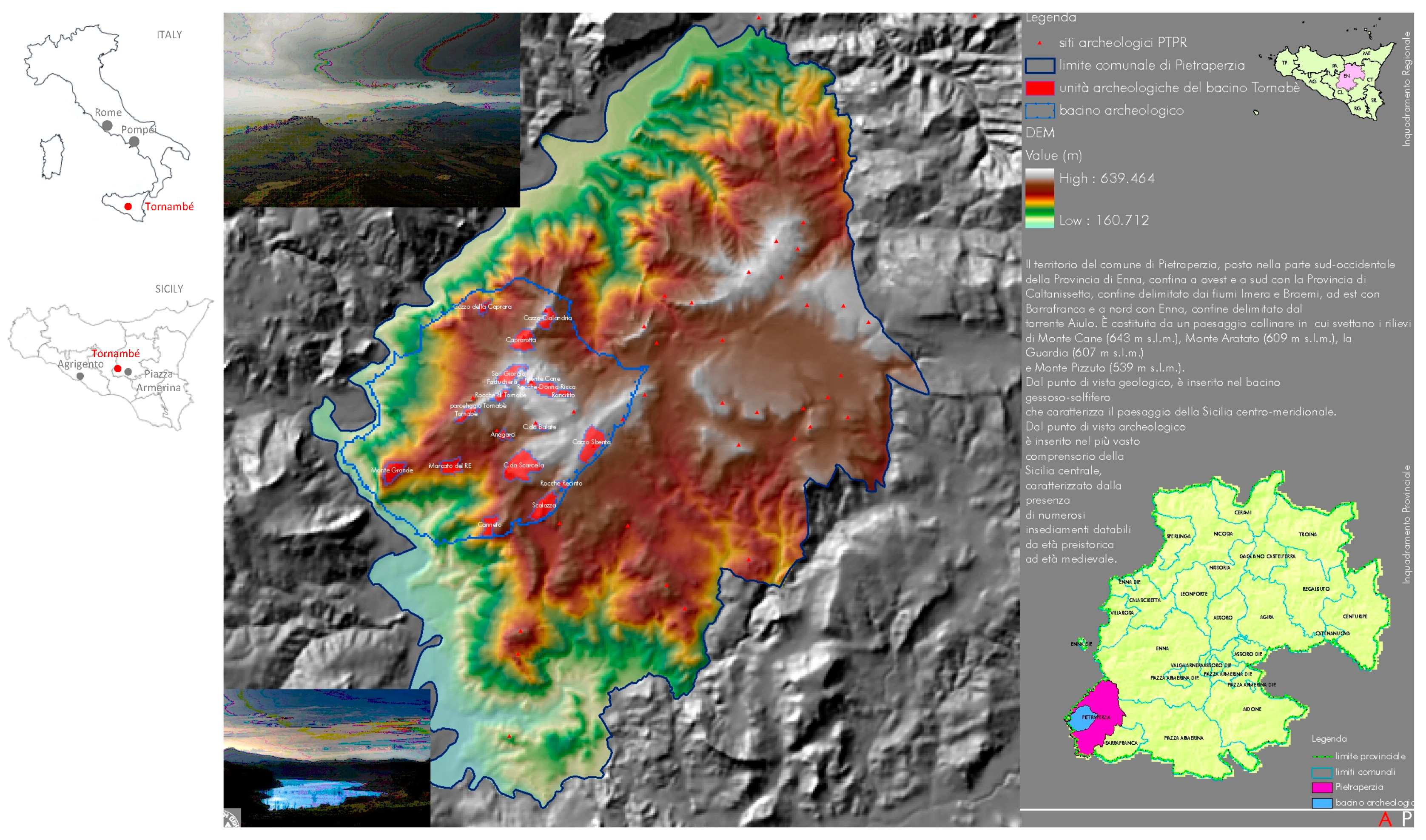
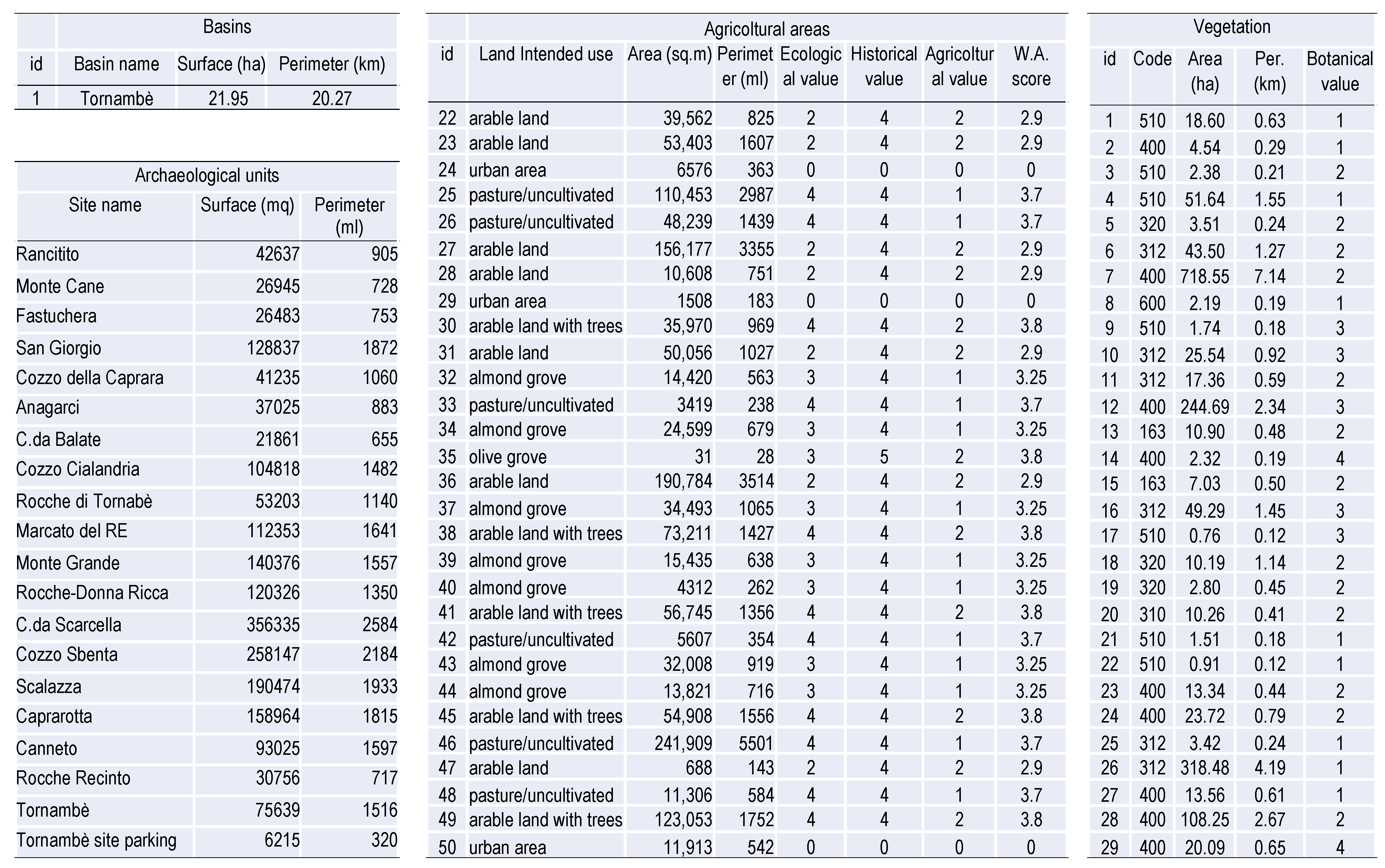
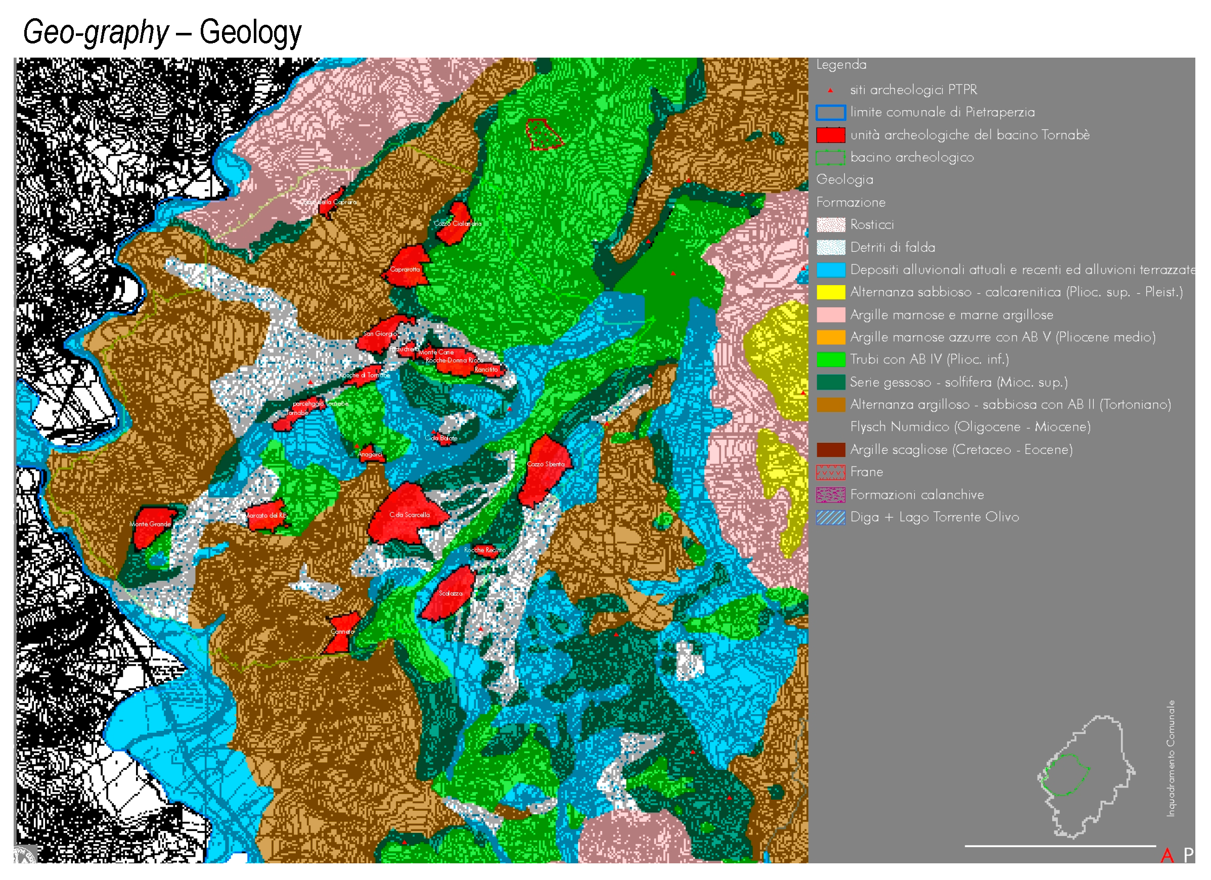
2. Materials. The Archaeological Basin of Tornambé

The archaeological basin of Tornambé (municipality of Pietraperzia, Italy) (Figure 1 and Figure 2) was chosen as an example of the archaeological heritage that is not part of the main tourist itineraries. In Italy, parks or archaeological sites of great importance are visited every year by several million tourists, e.g., the “Colosseum and Roman Forum” archaeological park in Rome had about 7.6 and Pompeii 3.6 million visitors in 2018, with revenues of 53.8 and 39.6 million euros respectively [61]. In Sicily, which is the Italian region where Tornambé is located, the numbers of visitors to the archaeological sites are lower. In fact, in 2018 the visitors were 928,952 and 354,941, with revenues of 6.6 and 2.6 million euros respectively in the “Valle dei Templi” archaeological park in Agrigento and in the “Villa romana del Casale” archaeological area in Piazza Armerina [62].
The Tornambé site is located in central Sicily on the top of a rocky ridge in a system of the hills Monte Grande, Tornambè, Rocche di Tornambè, Monte Cane, Cozzo Cialandria e Parcazzo that delimit the valley of the Imera river. The area is of great naturalistic value, in fact, the ridge above the Imera river has been recognized as a Site of Community Importance (according to the Ministry of the Environment Decree 3 April 2000) in order to preserve biological diversity, as it constitutes an emblematic example of the Mediterranean bio-geographic region characteristics. In addition, the area is part of the “Monte Capodarso and Imera valley” nature reserve.
This area is of archaeological interest as it has been inhabited for millenniums, since the prehistoric age, given their strategic location of controlling the Imera valley [63]. In fact, several excavation campaigns, from 2002 to 2012, found evidence of settlements dating back to the third millennium BC until the Greek age in the VII–VI century BC [64]. The surface reconnaissance activities and excavation campaigns from 2003 to 2007 (financed by Progetti Integrati Territoriali—PIT 11.496 of Programma Operativo Regionale—POR Sicilia 2000–2006) and another two excavation campaigns in 2008–2009, that were carried out thanks to a cooperation between the Municipality of Pietraperzia, the Sopritendenza BB.CC.AA. of Enna and a local Centro studi archeologici, allowed to expose the remains of a large necropolis and a village from the Copper Age (2700–2300 BC), the latter is formed of numerous huts having circular structures [65,66,67]. In this area, many pottery sherds, as glass or pot fragments, are present. Petrographic and mineralogical analyses carried out on ceramic samples dated them from the Copper Age to the Early and Middle Bronze and evidenced a certain continuity regarding the supply of raw material for a very long period, independently of the different cultural phases [68]. Moreover, in the site, there are numerous ‘oven’ tombs from the Bronze Age (2300–1600 BC), as well as some chambered tombs even monumental in size and other architectural elements dating back to the archaic Greek age (VII–V century BC). Furthermore remains of a phrourion, that was a military outpost consisting of rectangular rooms and cisterns dug into the rock, are located on the top of a hill to protect of the settlement [69]. In 2012 another excavation campaign started thanks to an agreement between local public authorities and a private local cultural association. Nevertheless the numerous archaeological finds, currently, accessibility to the site is difficult and there are no services for tourists, with the exception of some information panels and some paths inside the area, and only a few people sporadically visit the site on the initiative of local cultural associations.
The site of Tornambé is located in a wider territorial, environmental and landscape context which is the result of the essential integration between cultural and natural values, as it can be seen from the thematic maps, that have identified the territorial resources of the network within an area of approximately 2200 hectares, such as other minor archaeological sites, some places of naturalistic value, e.g., the San Giorgio or Monte Grande springs, or of testimonial interest such as the Monte Cane mine.
The Province of Enna government has mainly focused on the cultural policy of the archaeological heritage on the most important sites of the Province, Piazza Armerina (Villa del Casale) and Aidone (Morgantina). However, in recent years, the growing eco-environmental sensitivity and the general touristic demand diversification trend, integrating cultural and landscape heritage, as well as social events, local food and wine products, etc., have segmented users and induced the redistribution of a share of tourist demand towards inland areas of Sicily. In this context, the Tornambé site has the potential to capture part of the existing tourist flows to which to propose a composite offer, according to the concept of integrated conservation of the territory, thanks to numerous factors such as the proximity to the massive tourist flows of Piazza Armerina and Aidone and to a high-speed thoroughfare, the favourable altitude position with consequent landscape value. Furthermore, the site presents a remarkable complex of geomorphological, hydrogeological and vegetation values, integrated into the ethno-anthropological and cultural context of a still unspoiled territory, to which such an ancient and rare archaeological framework can give a primary and original significance.
This opportunity for enhancement generates, as a virtuous aspect, the involvement of local economic activities and a broader awareness of the value identity of places and also the strengthening of social cohesion. This prospect fits the progressive dematerialisation trend of an economy as for the contribution that the increase of the cultural-contemplative services demand can provide: 1. to rebalance the town/countryside relationship as for the location demand of people and businesses, 2. to rebalance the relationship between mass and cultural—as well as between inland and coastal—tourism, in support of the preservation of the cultural estate territorial framework.

3. Methods. Territorial, Economic and Landscape Communication

This study explores some aspects of multiscale integrated analysis, valuation and project approach to the protection and promotion of widespread archaeological heritage, in a territory, such as the Province of Enna, characterized by low-value-density cultural networks, and as a consequence by the emotional rarefaction of the “tactile experience”.
In this context, the weak structure of the archaeological outcrops constitutes the main and original resource of cultural heritage which rediscovers its “original magnificence” in the shared awareness of the complex value expressed by the entirety of the landscape unit [70].
Accordingly, a general framework connecting territorial knowledge, economic valuations and cultural policies have been the methodological reference of this experience (Figure 3).
This evaluation experience tries to connect aspects of the organization of knowledge, formalized with the use of GIS [71,72,73,74,75,76,77], with the economic analysis tools for efficient and effective management of the territorial cultural heritage, in a territorial context characterized by a low-value density.
The well-known economic unbalance and financial unfeasibility of the cultural enterprise typically aimed at providing streams of contemplative services, thus pursuing the growth of the immaterial component of the social territorial estate, is mostly due to the asymmetry between monetary, certain, initial, point and higher costs, on the one hand, non-monetary, uncertain, differed continuous and minimal, although widespread, benefits on the other hand.
Accordingly, the proposed analyses aim at defining the conditions of the cost-effectiveness of an archaeological-landscape network plan as conceptual and operative support to the cultural-asset-oriented territorial-landscape policies.
In such a complex decision-making prospect, one of the main theoretical and methodological criticalities of appraisal/valuation science arises, that is its relationship with project/planning activity [78]. Even today, valuation is considered to be a simple tool of design, whose output—at the end of a somehow self-referential design process—is verified by valuation, turning this design output into a social outcome. From such a perspective, a project is connected to representation and the decisions have a weak relation to the layer of shared values [79]. In this case, a top-down communication process is established, in which economic valuation plays the role of validating the choices coming from the top [80,81].
The basic hypothesis of this perspective inversion is that this valuation/project relationship can be reversed so that the integration of economic valuation in the project process can integrate top-down and bottom-up decision-making processes, thus improving social-economic communication.
Accordingly, this experiment covers three “communication areas”:
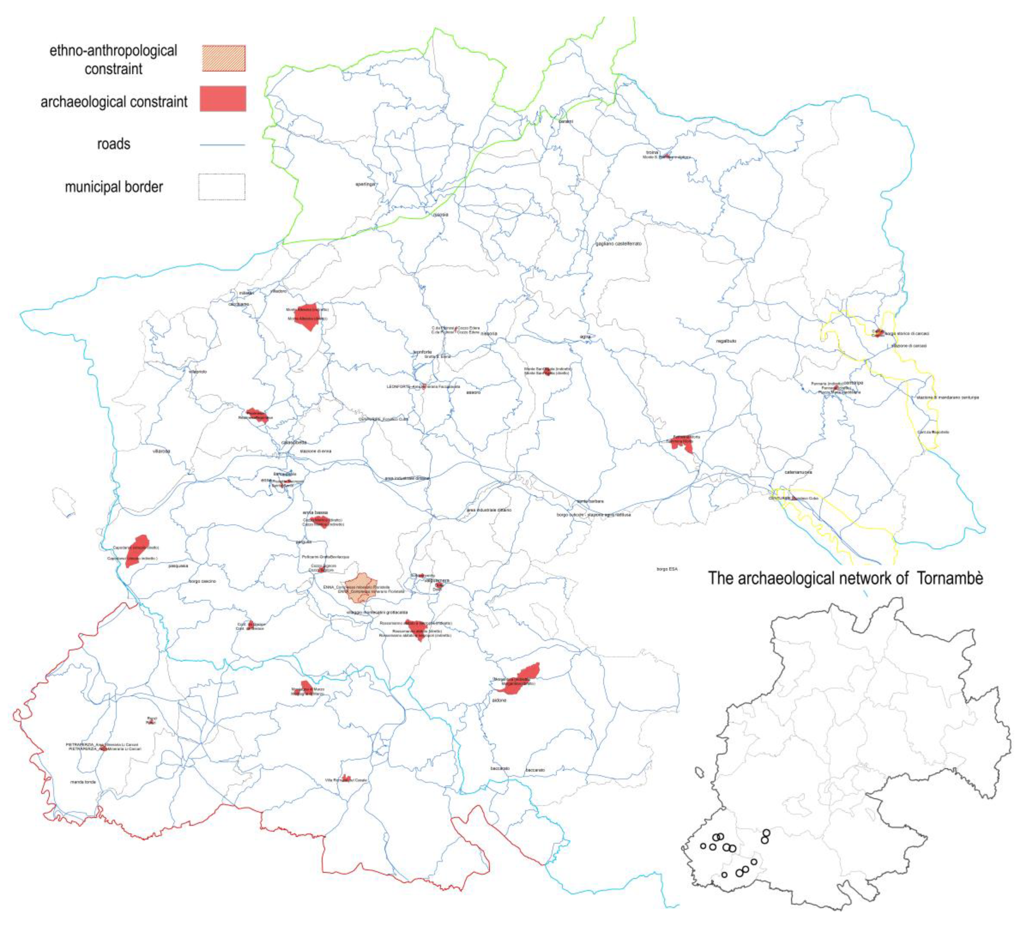
  • the “territorial communication” concerns the identification of the different archaeological networks of the Province of Enna and has been carried out in a previous study developed on a territorial scale. These networks consist of landscape contexts coherent with the underling archaeological sites and have been characterized on the basis of the geodatabases based on which the Guidelines of the Regional Territorial Landscape Plan have been created,
  • the “social-economic communication” concerns the economic calculation aimed at connecting the cultural-contemplative instances and the social-territorial economic development opportunities. Once identified the archaeological network on which to test the economic potential of a “research, experiencing and promoting” program hypothesis—a DCFA was carried out aiming at estimating the number of costs and revenues, and therefore verifying the conditions of cost-effectiveness and financial sustainability [82,83] of a typical enhancement and development hypothesis of an archaeological basin. The evidence of the economic-financial imbalance of the cash flow required the development of a subsequent in-depth phase,
  • the “landscape communication” concerns the connection of the different players of the archaeological-oriented landscape redevelopment process. Two types of hypotheses were made: the first concern the allocation of the costs among the players identified as both stakeholders and especially stockholders. The second concerns the dynamics of the economic potential of the program, as a result of the development of the activities planned in the three action areas—research, experiencing and promoting.

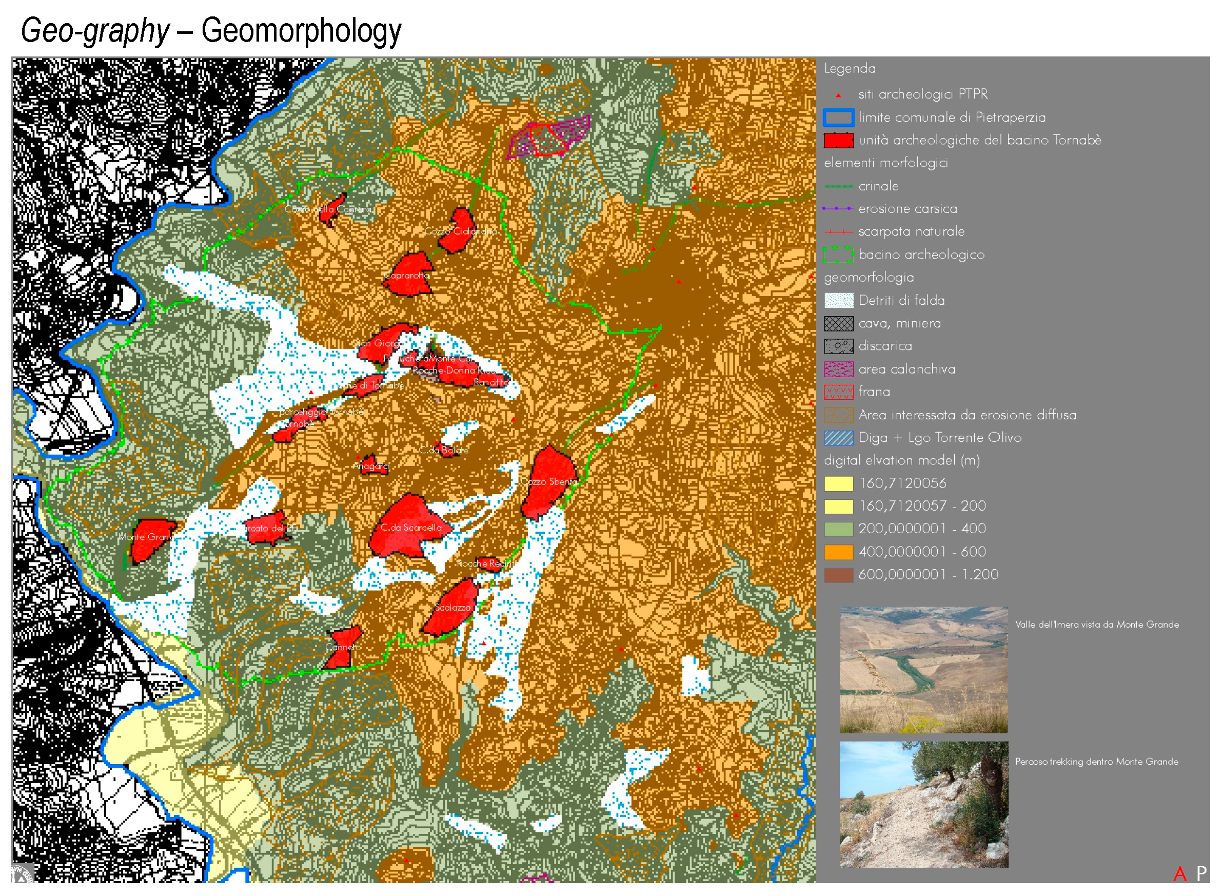
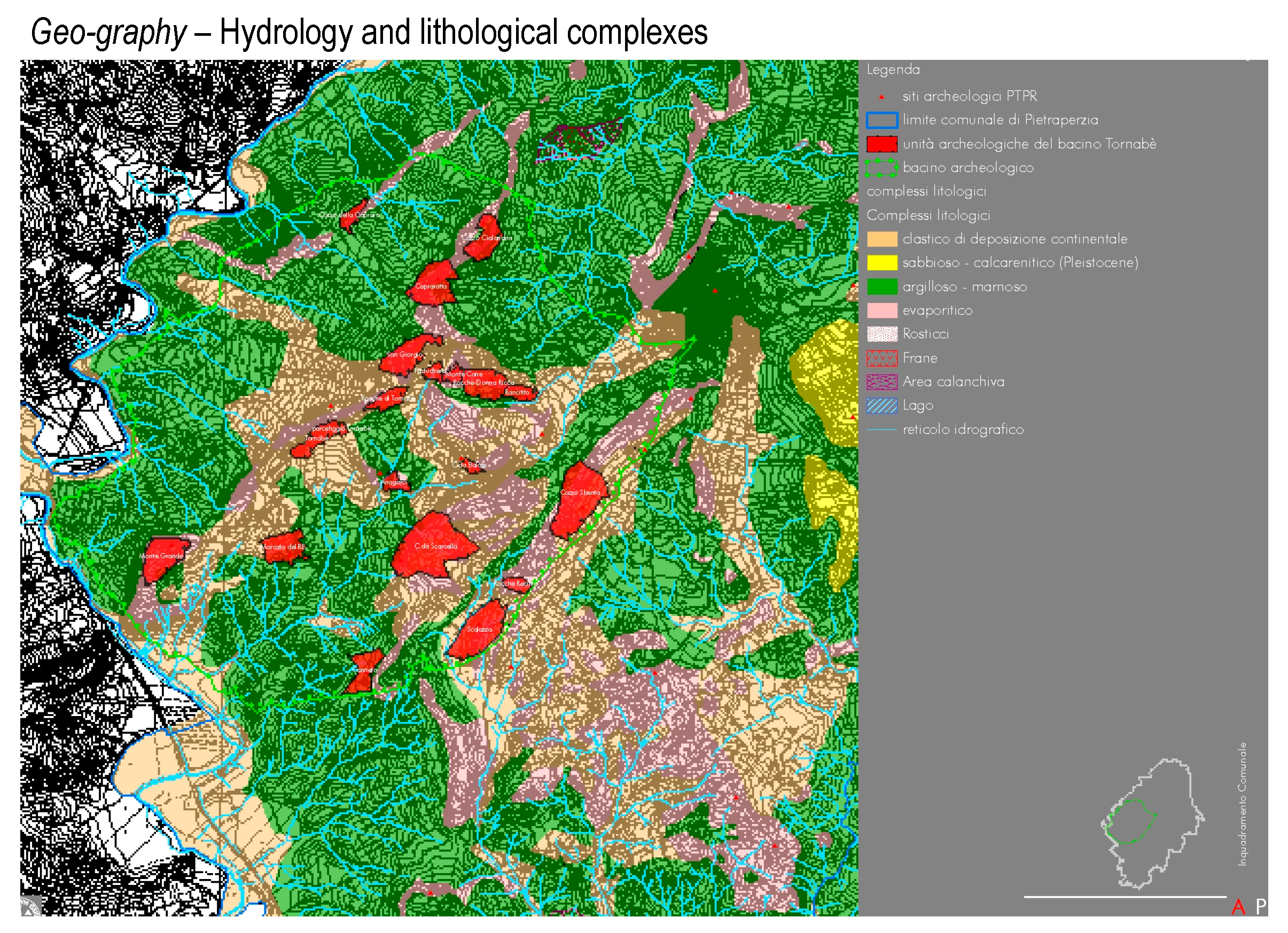
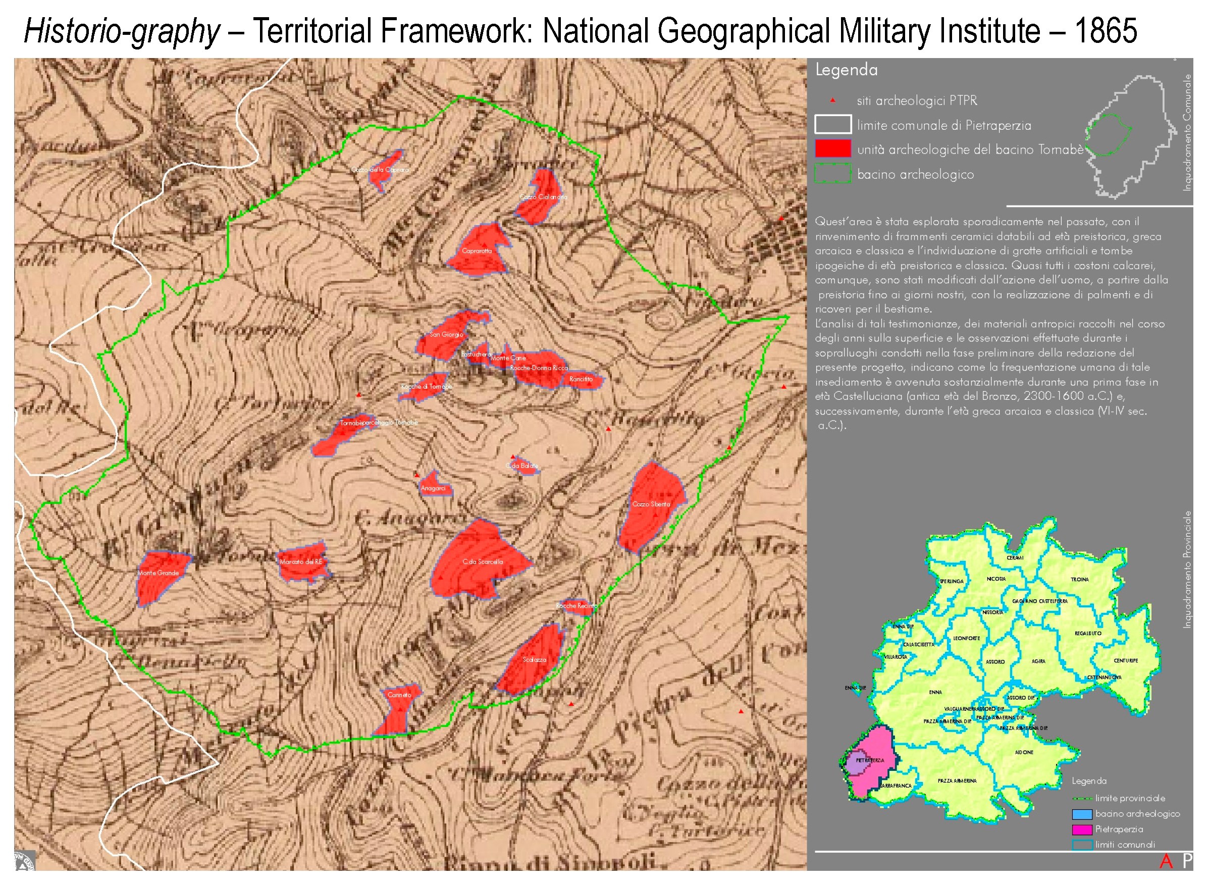
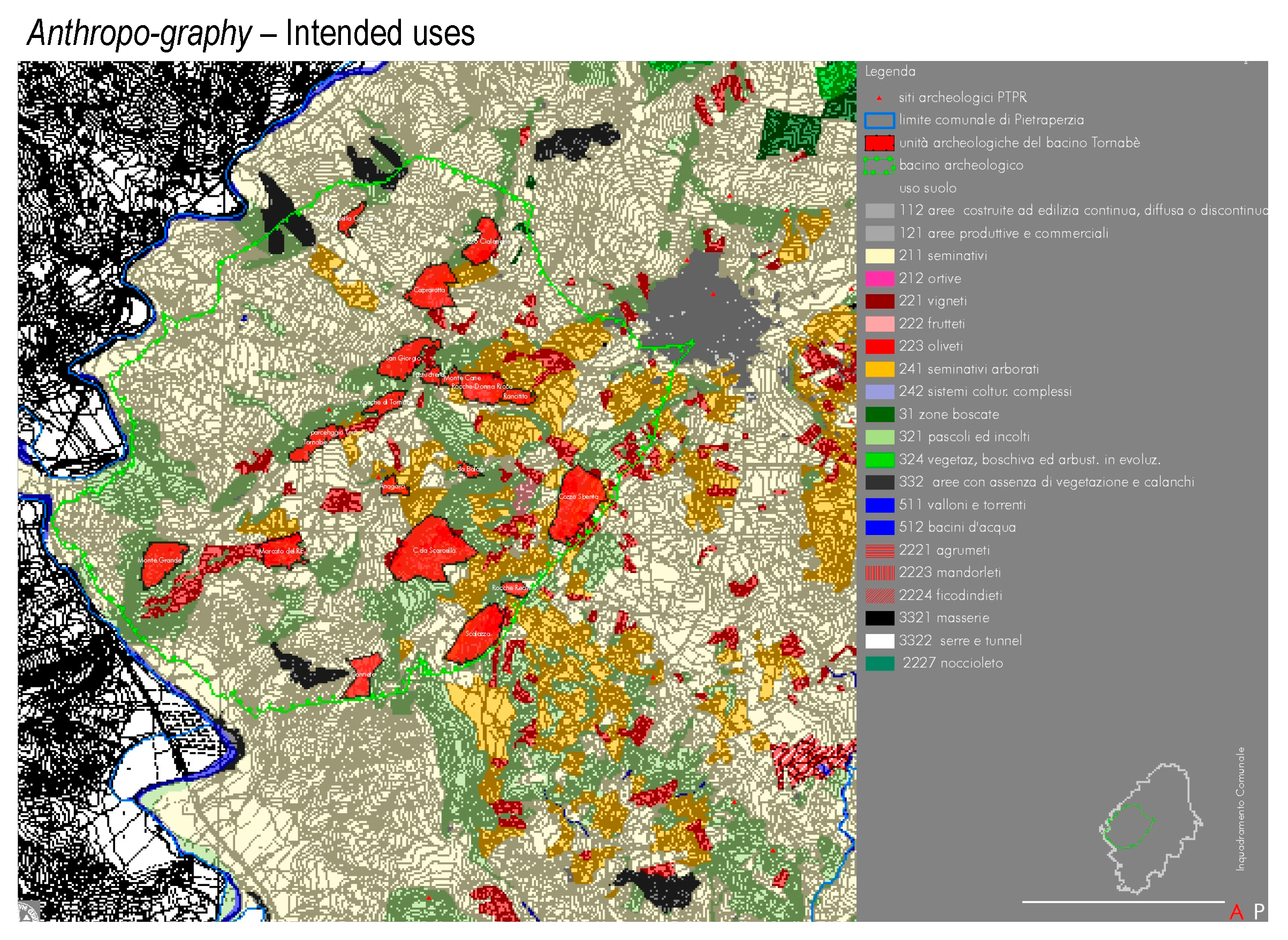
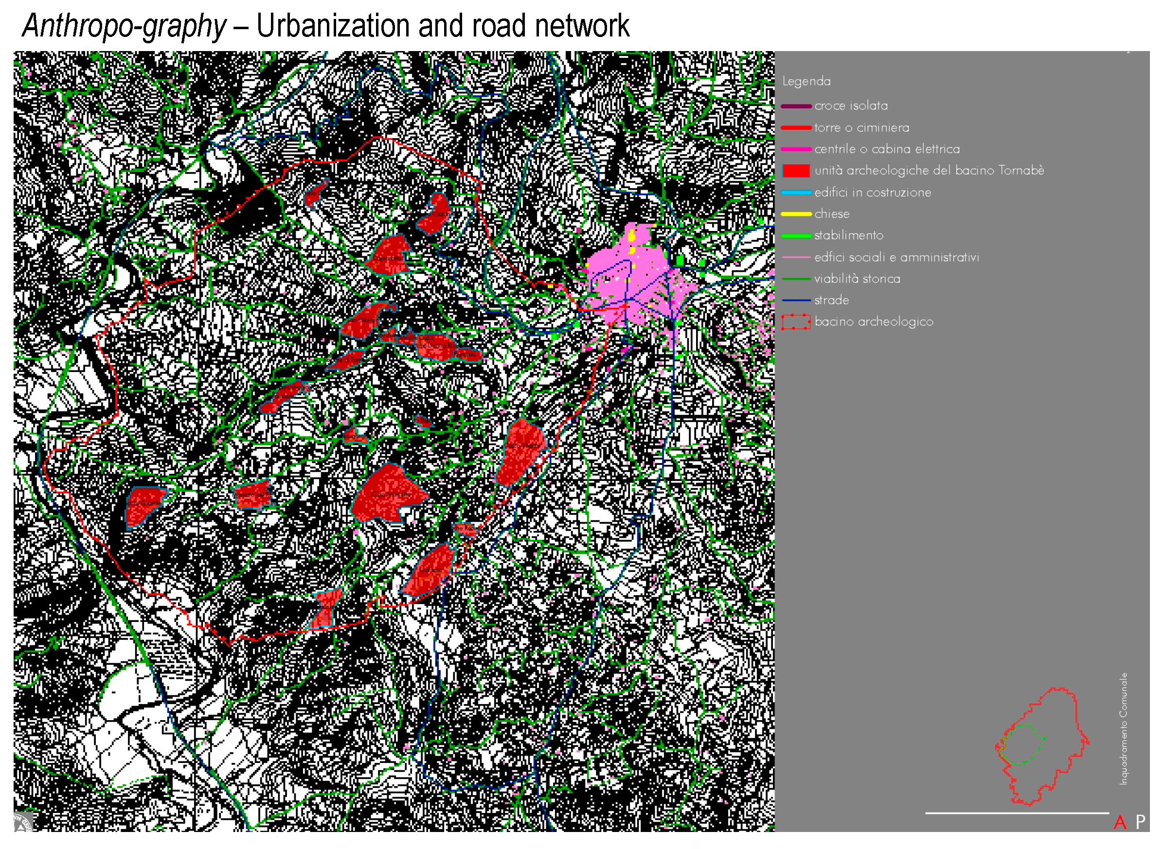
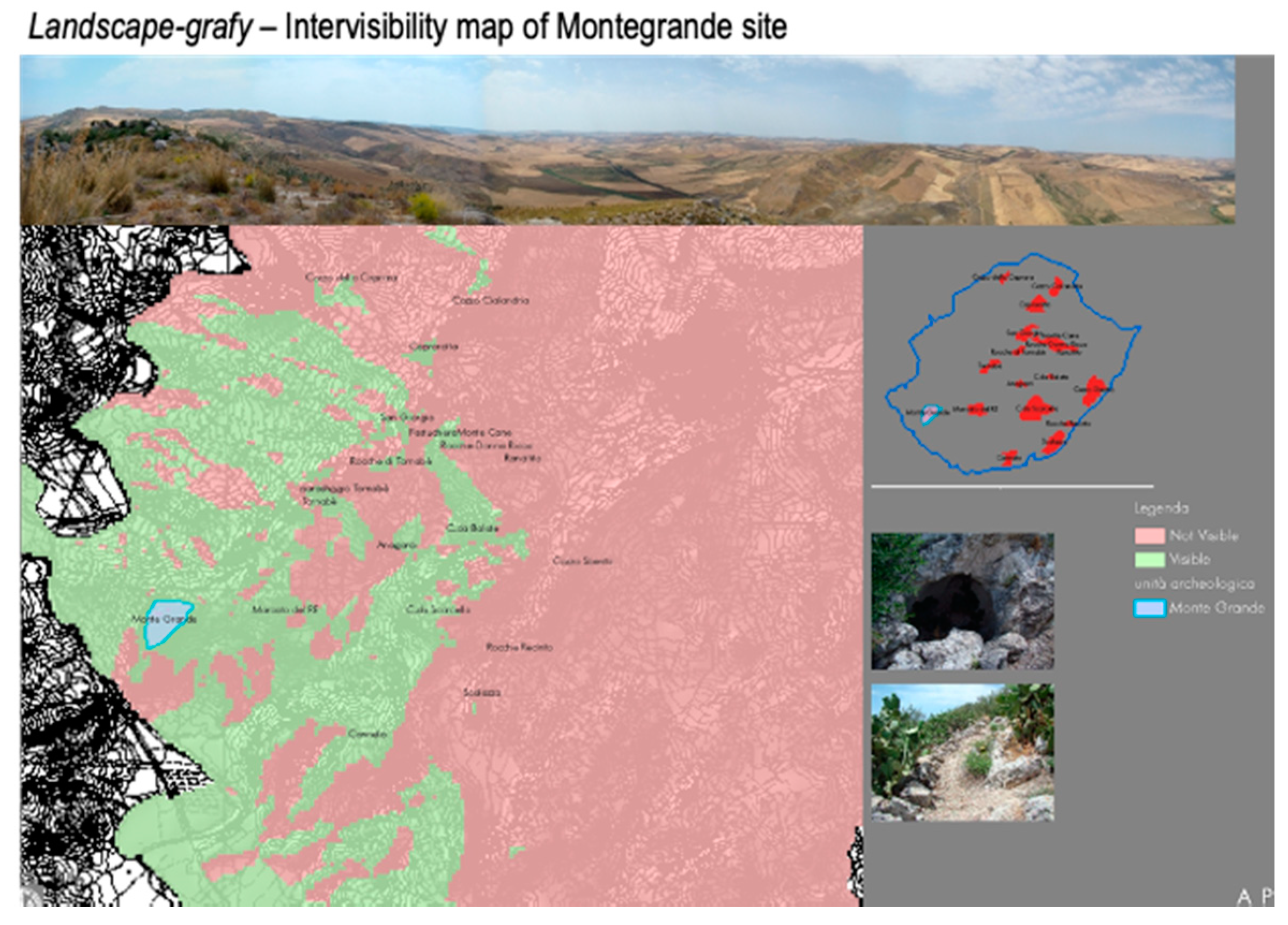
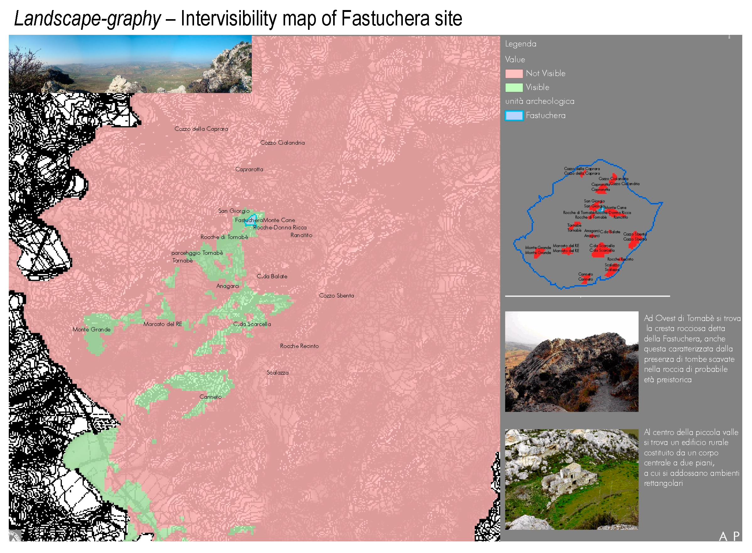
3.1. Territorial Communication. Representation as a Prospect for Identifying the Archaeological Basins

The representation of territory through the prism of the landscape has been carried out in Sicily by means of the Guidelines of the Regional Landscape Territorial Plan [84] approved in 1999. Each of the nine Sicilian Provinces has or should have, draw its own Provincial Landscape Territorial Plan (PTLP) as the province of Enna did [85].
This document can be considered a territorial communication tool as for the standardized basic land information basing on which the activities of transformation and preservation of territorial and landscape units should be ruled.
Accordingly, the identification of the archaeological constraints of the Province of Enna [86] was carried out by first identifying the sites surveyed by the above-mentioned PTLP, from whose geodatabase the information and assessments characterizing their landscape relevance were extracted. Subsequently, the various sites were grouped into clusters—internally homogeneous and externally, that is compared to each other, heterogeneous—on the basis of similarity and complementarity relationships, whose parameters can be modified so as to allow the generation [87] of alternative configurations.
The relations of similarity and complementarity concern the original distinction of the basic three landscape components:
  • abiotic (the biotopes), i.e., the geo-lithological and morphological components of the landscape,
  • biotic (the biotypes), i.e., the vegetational, faunal and agricultural components of the landscape,
  • anthropic, i.e., the cultural, built and infrastructural assets.
The 229 sites of the Province have been included in a database, of which they are the records and whose fields are the relevant characteristics extracted from the PTLP, the territorial profile of each of them has been defined in terms of compliance with a specific landscape matrix: 1. Agricultural, 2. Vegetational, 3. Geological, 4. Anthropic, 5. Cultural, 6 Infrastructural, 7. Architectural.
The landscape profile is represented by measurements that define value functions such as distances from infrastructures, presence of attractors or detractors, presence and consistency of valuable areas included within an established buffer. The themes are: historical, contemporary and railway roads; territorial and archaeological constraints; the presence of isolated goods; quarries and landfills; reserves, forests, Sites of Community Interest (SIC) and Special Protection Areas (SPAs); land uses; habitats; geological structure.
Furthermore, in order to define and identify the archaeological basins, the matrix of the mutual geometric distance of the sites was calculated to verify the spatial continuity of the basin with reference to the usability of the sites included in it.
The value functions of the individual thematic characteristics were subsequently defined for each of the seven landscape matrices, and for each of the latter, a specific system of weights has been established, that allows aggregating the characteristics in the seven scores for each site, with reference to each landscape matrix [88].
Among all the basins of the Province of Enna, the archaeological network of Tornambè (Figure 2) has been identified as an archaeological network currently characterized by a low-density archaeological value but having a relevant potential due to the multilayer connections between the landscape matrixes above described.
Once identified, the Tornambè basin was characterized through a detailed representation of its axiological and aesthetic layout, on the basis of which it was considered possible to prefigure a general scenario of development of the archaeological research, sustainable touristic experience and culture-oriented economic promotion.

3.2. Socio-Economic Communication Project as a Valuation Tool in the Archaeological Asset Development

The creation of a social-economic communication tool is the operational core of this experiment, aimed at measuring the economic profitability and the financial feasibility [89] of a standard archaeological basin development project by carrying out a Discounted Cash Flow Analysis [90]. The project hypothesis includes the actions (investments and management activities) requested to connect and develop the works aimed at creating the cultural assets and the related management operational unit involving a wide platform of private and public players.
In addition to the results of the territorial quantitative and qualitative analysis, the functions of the Geodatabase allowed us to extract and coordinate the spatial data necessary for the drafting of the preliminary project and the economic calculation of the development hypothesis.
Although the archaeological basins of the Province of Enna are quite different from each other, this hypothesis can be considered a sort of pilot project whose economic-monetary ratios provides standardized information about the interactions of the different players and the related instances and interests.
As well known, the DCFA is the comparison of revenues and costs of an investment within a given time span, the time horizon of the project [91]. The first step of this economic knowledge analysis has been the calculation of revenues and costs that have been carried out basing on their unit size.
The unit revenues were taken basing on specific market surveys of the goods and services that can be placed on the market. The total revenues were calculated according to a prudent scenario [92] concerning the users that could be attracted by implementing the activities included in the contemplative, recreational and educational program.
The unit costs have been taken both from specific market analyses and (especially for the building works) from the Bill of quantities for the Public Works of Sicilian Region 2018. The total costs have been calculated based on the dimensions of the involved geo-referenced areas and paths which have included in the geodatabase and whose development or renovation is supposed.
In order to make comparable the investment (point) costs ( C p ) to the annual operating (continue) costs and revenues, the former have been transformed in streams of constant annuities ( C ¯ i ) by associating to each of them the economic lifetime ( n ) of the corresponding asset and, according to the current financial market interest rate ( r d ) [93], the annuity was calculated by the following amortization formula:
C ¯ i = C p r d ( 1 + r d ) n ( 1 + r d ) n 1
Furthermore, in order to quickly develop scenario analyses, the economic evaluation model is set up to enable or disable items, to attribute these items to different actors, to modify all the financial variables involved, such as the discount rate [94,95], the interest rate on amortization and so on.
The cost-effectiveness for the private entrepreneurial player, in this case, a Special Purpose Vehicle (SPV), can be represented according to the following results and indices:
  • the Net Present Value ( N P V ) is the sum of the incoming and outgoing cash flows, that is revenues ( R ) and costs (C), over a defined time horizon ( T ), discounted at the discount rate r . NPV is less, equal or more than the (net) Future Value (FV) if the discount rate ( r ) is more, equal or less to 0, N P V is expected to be significantly positive in case of a private player:
    N P V = i = 0 T R i C i ( 1 + r ) i 0
  • the Total Rate of Return ( T R R ), that is the more significant index of profitability thus the ratio between N P V and the present cost, T R R should be greater than the opportunity cost of capital c .
    T R R = i = 0 T R i C i ( 1 + r ) i i = 0 T C i ( 1 + r ) i c
  • the Internal Rate of Return ( I R R ), that is the discount rate r I R R at which N P V = 0 , that is the maximum rate of return that can be extracted by an investment. It only depends on the distribution of the stream along the time horizon of the investment:
    i = 0 T R i C i ( 1 + r I R R ) i = 0
  • the External Rate of Return ( E R R )—also called Modified Internal Rate of Return (MIRR)—refers to both the cost of the investment and the interests on reinvested cash, and is calculated on the basis of an interest rate external to the investment, at which net (positive) cash flows generated by the investment over its time horizon can be invested or borrowed r * . The External Rate of Return r e * is the rate at which the investment costs discounted at the rate r equals the future value at time T of the positive Cash Flows ( C F i ( > 0 ) ) deferred at the rate r * , given C F i = R i C i , in other words, ERR is the IRR of an ideal investment whose unique cost is the initial investment cost calculated as the NPV at the rate r of the negative cash flows over the time horizon T , and whose unique revenue is the future value (at year T) of the positive cash flows at the rate r * , this particular IRR is r e .
    i = 0 T C F i ( < 0 ) ( 1 + r e ) i = i = 0 T C F T 1 ( > 0 ) ( 1 + r * ) T i
  • the Elasticity ( E r ), that is the marginal N P V at the discount rate r :
    E r = δ N P V r N P V r δ r r
  • the Discounted Payback Period ( D P P ) is the number of years it takes to break even from undertaking the investment cost ( I 0 ) by discounting future cash flows and recognizing the time value of money ( r > 0 ), the higher the discount rate, the longer the D P P , more simply, a Payback Period ( P P ) can be calculated without taking into account the time preference rate ( r = 0 ). In general, P P is the ratio between the total investment cost and the annual constant or average cash flow. Often, the variability of the cash flow over the lifetime of the project reduces the reliability of the formulas usually implemented for D P P , so that a more general formula can be proposed considering N P V ( i ) , and then:
    D P P = i N P V ( i ) = 0
  • the Average Period at the rate r ( A P r ) [48], that is a sort of time elasticity, that can be considered as the average period of deferral of the i t h annual net discounted Cash Flows ( C F i ) given the discount factor,
    A P r = i = 0 T i C F i ( 1 + r ) i i = 0 T C F i ( 1 + r ) i
The discount rate r is an important indicator of the intertemporal social solidarity practised with the implementation of the project, and it enables two different and complementary prospects, the private one as means, the public one as scope.
Concerning the first one, the discount rate can be assumed as the well-known Weighted Average Cost of Capital ( W A C C ), referred to the funds in terms of Debt ( D ) and Equity ( E ),
W A C C = i d D + i e E D + E
where   i d is the interest rate for debt and i e is the opportunity cost of equity, that can be respectively referred to the active and passive interest rates charged to households and consumers, according to the statistics of Bank Italia (2017), set at 4.66% (over a 5 years life of the loan) and 0.12%, assuming leverage of 50%, W A C C is 2.39%.
Concerning the second one, although the economic-financial valuation is carried out here form the private player perspective, it should be remarked that the whole project involves a wide range of public players providing the private one with the political-administrative support and the socio-cultural context allowing the business success.
As a consequence, as for the size as well as for the role it plays in the socio-economic intergenerational communication, the discount rate can be considered to be a sort of Social Discount Rate that the extensive literature on the subject [96] agrees should have a nearly zero value. The prospect of an economic communication able to involve as many players as possible encourages researchers to support a low-discount rate territorial-economic culture as one of the fundamental pillars of sustainability involving the relationship between the social system and the environment in the prospect of establishing of an actual and effective landscape communication.

3.3. Landscape Communication. Valuation as a Programming Tool in the Archaeological Asset Protection

The central role that landscape should play in the social and economic communication, in the specific field of the enhancement of the land cultural asset, demands the convergence of the social-economic players’ perspectives (the viewpoints) towards sustainability (the vanishing point), once outlined the actions and the financial-economic profile of the archaeological basin development hypothesis.
The early comparison of revenues and costs provides the decision-makers with:
  • a significant measurement of the overall imbalance between revenues and total cost,
  • the degree of—and the conditions for—the cost-effectiveness and financial feasibility of the investment limited to the revenues of goods and services that can be placed on the market.
Both the results encourage and guide the decision-makers (as part of the political-administrative social sub-system) the stockholders (as part of the economic-financial social sub-system) and the stakeholders (as parts of the cultural sub-system) to converge towards a shared arrangement of tasks and economic-financial commitments. This convergence is supported by the hoped shared awareness that the amount of costs that cannot be covered by the revenues represents the economic measurement of the minimum social value of this archaeological-landscape asset. Such awareness supports the improvement of the landscape communication if: 1. this cost surplus is actually incurred by the political-administrative and cultural sub-systems, 2. such political-cultural choice is shared by the public. Now, concerning the two complementary functions of the revenue-cost comparison:
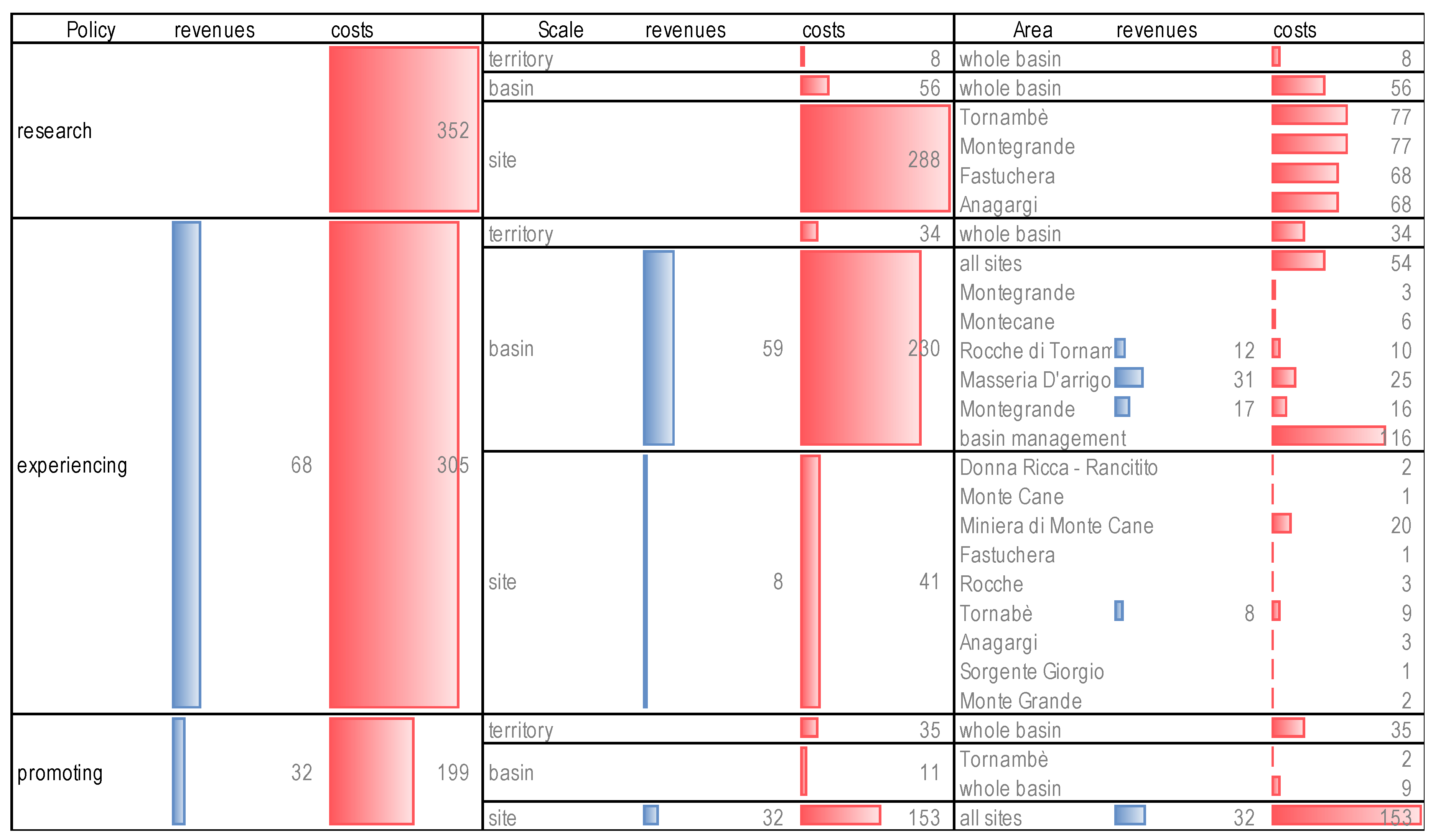
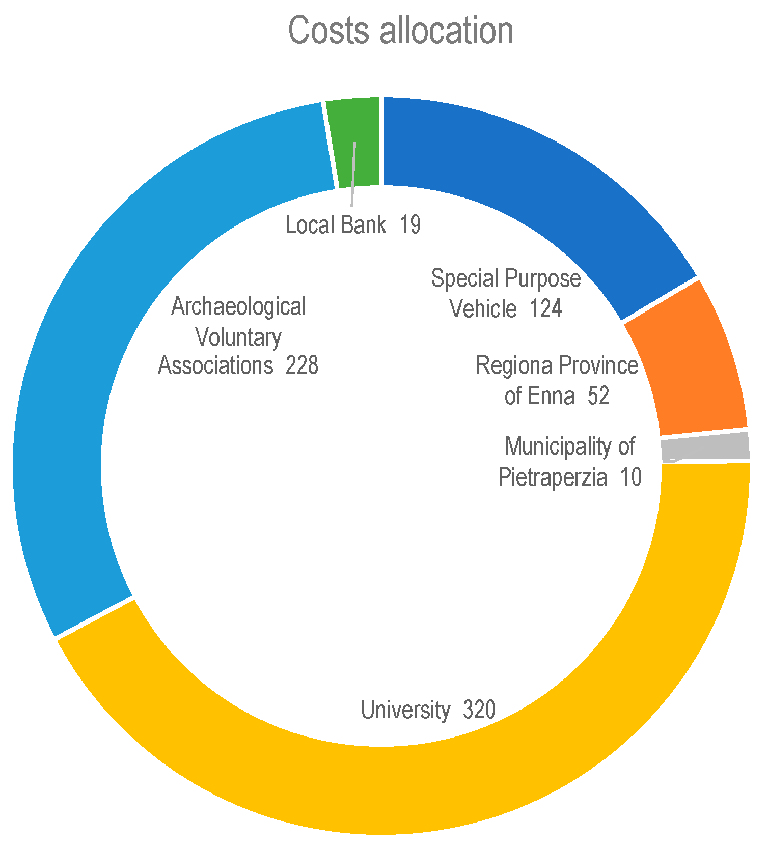
  • as for the first one, starting from the evident revenue/costs imbalance that no further study could reduce, a cost allocation pattern between the players can be hypothesized in order to support and encourage the private player initiative. The costs have been allocated according to the specific functions and institutional scopes of the public players involved, as explained in Section 4.3,
  • the second one—however, concerning the cost-effectiveness analysis for the private player, that is the entrepreneurial layout of the archaeological basin management—can take advantage of some further studies concerning the percentage incidence of the different cost types, the scenario analysis and the sensitiveness analysis aimed at identifying the strategic economic and financial variables and their connection to the cultural, management features influencing the outputs of the DCFA.
The focus on the stake/stock-holders relationship is one of the several oppositions which the economic valuation usually deals with, each of these oppositions can often also result in a form of complementarity. The unavoidable overall economic unprofitability and financial infeasibility of the development of a landscape-archaeological unit intended to cultural, contemplative and recreational uses, is a measurement of the opposition, and somehow of the complementarity, between:
  • the transformative actions, such as the development of the built environment, recreational functions, commercial activities and so on,
  • the conservative ones, such as the expansion of the excavation areas for archaeological research, the widespread musealization in situ, the creation of panoramic equipped areas, the development of the cyclo-pedestrian road network and so on.
This conflict, in turn, highlights the intrinsic complementarities of different dimensions of the landscape that is an overarching entity including and displaying in a typically multifaceted shape its own complexities and contradictions.
Accordingly, the economic-financial variables have been assumed as project/program items and as such, they have been organized within a general conceptual and operative framework (Table 1) coordinating:
  • research, concerning the extension and dissemination of the archaeological knowledge,
  • experiencing, concerning the development and differentiation of the direct experience of tourism and education,
  • promoting, concerning the consideration of secondary and indirect economic activities that characterize all the sites as a unitary archaeological basin, also characterized in a socio-economic and political-communicative sense.
Each of the three above-mentioned general objectives has been represented outlining the related programming actions grouped according to the multiscale approach involving activities devoted to:
  • the territory, such as social communication and territorial marketing,
  • the basin, such as archaeological research and attraction of stakeholders and stockholders,
  • the site, such as protection, maintenance, development of the involved areas.
The path along the main diagonal of the matrix reports the stages of actions ranging from the immaterial services to the material goods, and from the general context to the particular places, as described below.
1-1 Research/territory. The creation of a descriptive Geo-Database/Web-GIS of the basin is one of the basic tools of territorial marketing. It should be organized according to the description of the different levels included in the local landscape units with reference to abiotic, biotic and anthropic systems, and could be available for queries from scholars, entrepreneurs, designers and public administrations.
1-2 Research/basin. Surface reconnaissance activities are planned to detect the presence of not yet known archaeological sites.
1-3 Research/site. Stratigraphic research and excavation campaigns are planned to increase the cultural offer of each site with reference to the volume and archaeological value of the remains. These activities must be diversified between the sites in relation to their potential but also with respect to the organization within the basin which is aimed at differentiating potential itineraries.
2-1 Experiencing/Territory. A section of the Web-Gis, by means of specific toolbars, could allow the potential users to customize the itinerary according to specific interests, preferences and cultural themes. Specialistic information can be stored and made available for scholars and institutions after prior accreditation and certification.
2-2 Experiencing/Basin. Maintenance works are planned for the main connection routes to improve the coordinated fruition of the sites included in the itineraries of greatest overall cultural value. Actions are also planned to improve touristic accommodation and services (agritourism, catering, riding stables, bicycle shelter and rental), infrastructures (roads and car parks), entertainment (temporary and removable structures).
2-3 Experiencing/Site. The following actions are planned: the realization of lighting systems, panels and fences, the redevelopment of internal paths, etc.
3-1 Promoting/Territory. The enhancement of the territory is obtained by creating connections with regional and provincial cultural events. The Web-GIS platform stores information on the most important cultural events and provides the potential itinerant archaeological-naturalistic events such as exhibitions, festivals and theatrical performances.
3-2 Promoting/Basin. Temporary and permanent laboratories will be set up in the archaeological, ethno-anthropological, botanical, geological, etc. fields, in collaboration with associations and universities.
3-3 Promoting /Site. Didactic and cultural events and performances are planned compatibly with the features of the different archaeological sites. In the most important sites, the remains can be musealized in new exhibition open spaces and new or reused ancient buildings. Other buildings are supposed to be intended to the restoration of the most important archaeological remains, also within workshops and open laboratories.
Accordingly, all the actions envisaged by the project hypothesis, have listed in the rows of a database divided into three sections each of which is sub-divided into three sub-sections. The columns, i.e., the fields, of the database report the characteristics arranged so as to perform scenario and sensitiveness analyses coherent with the above-mentioned three-parts subdivision, as below:
  • extensions, such as size, number of items or people involved or interested in,
  • design, such as the category of intervention (new building, renovation, maintenance, restoration),
  • type of goods, such as ground, properties, buildings, furniture, instalments, tools, vehicles, materials,
  • type of right supposed for the use of properties, such as expropriation, rent, purchase,
  • type of task: advice, management, job,
  • class of workers, such as director, officer, archaeologist, restorer, GIS professional, archaeological remain analyst,
  • economic variables, such as unit revenues and costs, the latter distinguished by investment and operative costs, the lifetime of the works or goods,
  • socio-political variables, concerning the player by which is supposed the action has to be promoted and the costs incurred, such as Special Purpose Vehicle, Sicilian Regional Authorities, Regional Province of Enna, Municipality of Pietraperzia, University, Archaeological Associations, Local Bank).

4. Application and Results

4.1. Territorial Communication: The Geo-Database

The Geo-database basing which the Guidelines of the RTLP and the PTPL refer to, allowed us to characterize the studied area, the archaeological basin of Tornambè that has been delimited as a landscape unit as follows.
As first the 229 archaeological sites of the Province of Enna have been individuated in the PTLP. Then, each of them has been characterized as for its landscape relevance and scored according to a metric representing the value of each category of the theme, which it belongs to. Finally, relations of similarity and complementarity have been established according to which the basins have been delimited and identified [97].
Once delimited the basin, its land area is divided into parcels that can be considered homogeneous with respect to each category of the related theme. Each parcel is scored according to a standard metric, set up in the PTLP, measuring the value of the parcel. By overlapping the different themes, the weighted average score of a generic item is calculated. For example, the relevance of a category of agricultural land use, such as almond grove, olive grove, pasture, etc., is expressed through the weighted average of the values of ecological, historical and agricultural values ranging from 1 to 5. The watercourses were assessed on a scale of 1 to 3 depending on the flow rate. Other landscape elements have been classified solely on the basis of location and size.
The geodatabase for the studied area reports the landscape themes from the PTLP, such as the geo-lithological and morphological ones, consisting of 14 categories, the vegetation and fauna themes consisting of 24 categories, the agricultural theme consisting of 21 categories and the cultural, real estate and infrastructure heritage themes consisting of 10 categories (Figure 4).
The thematic maps extracted from the Geo-database allowed us to outline a sort of “value-graphy” of the archaeological basin of Tornambè. Figure 5, Figure 6, Figure 7, Figure 8, Figure 9 and Figure 10 display some samples of geo-graphy (as for geology, geomorphology and hydrology), historio-graphy (as for the historic land framework of the archaeological network), anthropo-graphy (as for land intended uses, urbanization and road network).
The landscape connection between these different value dimensions, or ways to be wort, concerns the direct and/or indirect experience of the territorial context, the former related to the accessibility, the latter to the intervisibility map of the different archaeological sites.
The accessibility can be represented through the matrix of the distances of the sites from each other, the intervisibility map is the land area that is visible from each site and from which each site is visible. Figure 11 and Figure 12 sample the intervisibility maps of Montegrande and Fastuchera sites.
The key findings of this step are multiple interpretations of the territorial context given by the possibility to overlap the landscape (abiotic, biotic and anthropic) value maps and the intervisibility maps concerning the different archaeological sites included in the basin.

4.2. Socio-Economic Communication: Appraisal, Accounting, Assessment

The development project was detailed grouping the actions to be carried out: (a) in the areas of research, use and enhancement, (b) on the scales of territory, basin, site, taking into account the characteristics of the archaeological settlements and the potential of the relative territorial and landscape contexts.
For each action, the investment and/or operating costs, and the annual revenues have been appraised, as summarized in Table 2, Table 3 and Table 4.
Further synthesis of the above program allows us to distinguish and compare revenues and costs by policy [98] and scale (Figure 13). The amounts and the corresponding histograms display the expected clear unbalance between the scarce annual revenues (99,293 euro) and the huge annual costs (855,932 euro)that, more in general, characterizes the cultural-landscape asset economy, due to the emotional rarefaction of the contemplative experience in such landscape contexts.
As a consequence, the DCFA has been extended only to the economic goods and services that can be placed on the market, thus considering the economic-financial profile for a private player, a Special Purpose Vehicle (SPV), that could coordinate and manage all the actions needed for the development and protection of territory whose exceeding costs could be incurred by the other public players, as following explained.
Once selected the private components of the project (as proposed in the next sub-section), the cash flow has been drawn and the economic-financial results and indices have been calculated.
According to a basic hypothesis (H1), revenues have been considered constant over the entire 30-years lifetime of the project. This early simulation compares two possible distributions of the costs:
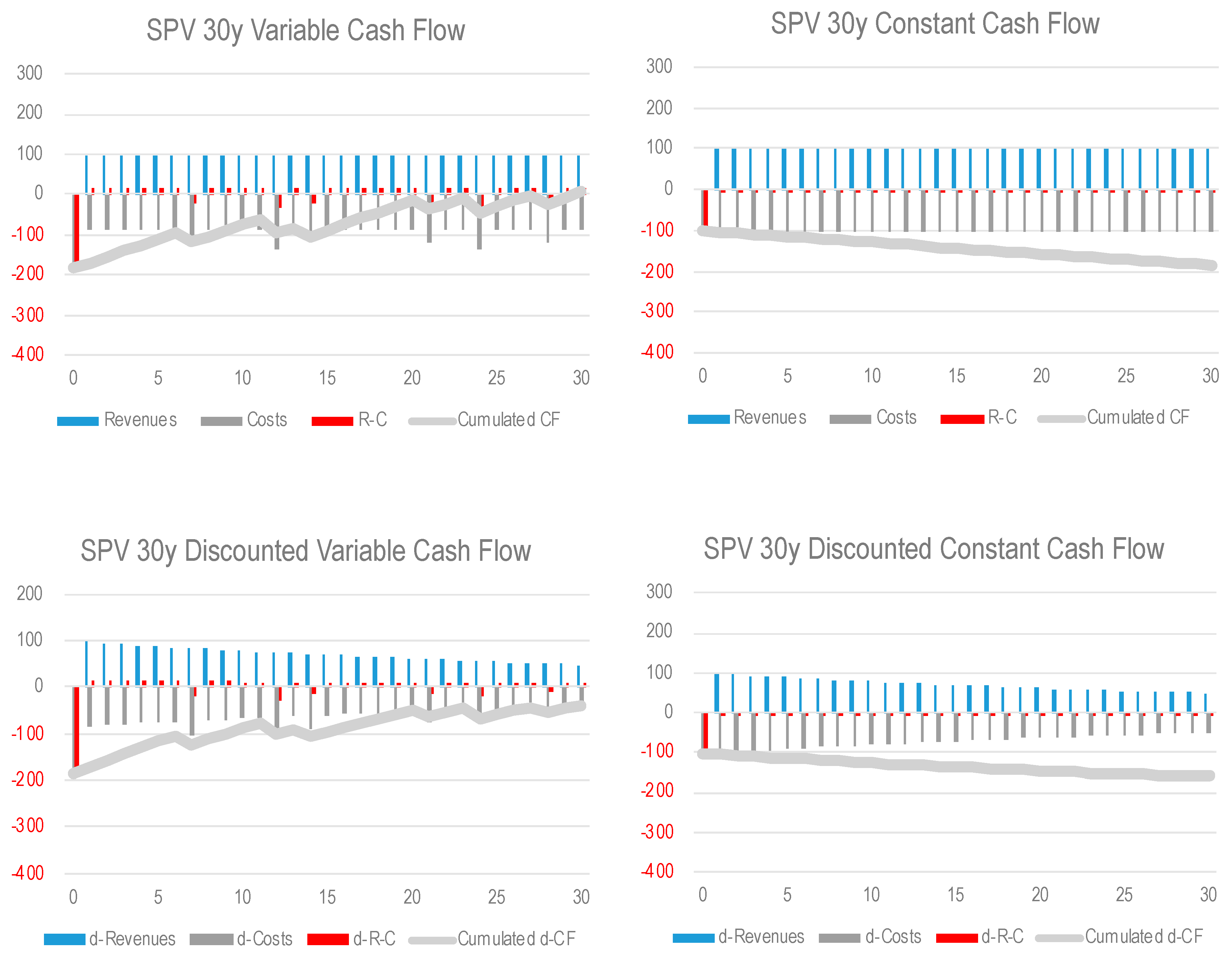
  • the first one (SPV 30-y variable cash flow) considers the cost for durable goods and works to be incurred again at the end of their lifetime,
  • the second one considering the costs to be constant each of them turned in a yearly depreciation charge.
Figure 14 displays both the not-discounted and discounted costs and revenues in order to show the effect of different costs and revenues, as well as the annual and cumulated cash flow.
This early hypothesis has been evaluated according to the above-explained economic results (NPV and TRR) and financial indices (IRR, ERR, AP, DPP) calculated taking into account the four above mentioned arrangements of the cash flow (Table 5).
These early results and the comparison between variable and constant cash flow show the advantage of the absence of interests for amortizations charges in the former hypothesis, while the comparison between not discounted and discounted cash flow shows the advantage of a zero-discount approach in the field of “landscape impact investments” in which, i.e., the public interest is the primary and original scope and the cultural heritage is the original asset of the fixed overhead capital.
At this stage is clearly shown the non-cost-effectiveness of the hypothesis that revenues keep being constant, that is contrary to the main concern of a multiscale/multiplayer process supporting the development of research (through the extension of the excavation campaigns) as the original condition to trigger a self-powering information-based economic process [99] starting from the most structural of the cultural patterns, the archaeological one.

4.3. Landscape Communication: Political, Cultural, Social and Entrepreneurial Accountability

As above mentioned, such a complex project involves landscape as the general cognitive/project dimension of the common act. The landscape is the ontological reference basing on which the identity of the settled communities arises: the more featured the local identity, the stronger the global connection and the opening to different people and cultures: as such, landscape involves and coordinates the political, cultural, social and entrepreneurial accountability.
In the proposed project, the subjects sharing this responsibility are a private Special Purpose Vehicle (SPV), the Sicilian Regional Authorities, the Enna Regional Province, the Municipality of Pietraperzia, the regional Universities, the local banks.
The management of the actions foreseen by the project could be carried out by a project company with the following tasks:
-
dialogue with local administrations to obtain public funding,
-
negotiation of credit lines with local private banks,
-
negotiation of concessions for the management of strategic areas of the basin,
-
promotion of activities that provide financial income such as visits, shows, workshops, workshops, excursions, etc.,
-
dialogue with cultural associations and public institutions (schools and universities) for the organization of cultural and educational activities,
-
integration of the activities of the local food and wine sector and tourism services (catering, accommodation, tourist guides, etc.).
Given the central role played by the SPV, a risk profile can be outlined assuming that a private corporate takes:
-
minor technical risks coming from the archaeological settlements, such as the enhancement of the road networks, the on-site cultural and educational activities, as for some logistic unexpected events due to possible meteorological instability and so on,
-
relevant commercial risk, due to the uncertainty of the tourists’/users’ attraction response, especially in the short run,
-
relevant management risk, concerning the continuity of the cash flow, due to the multiplicity of the players directly and indirectly involved, and to the articulation of the commercial and company policy as for tickets, fees and prices, given the lack of a single demand function, and to the interdependence of the different ones,
-
medium financial risk, given the complementarity of two opposite circumstances: the generally low-level of the interest rate on the one hand, and the unbalance between the little revenues and great costs on the other hand,
-
relevant political risk, due to the long run of the time span typically involved by cultural asset heritage development programs, and the generally high level of social time preference rate in a fragile socio-economic territorial context.
In order to control the aforementioned risk factors, the SPV can implement a multiplayer strategy coordinating the action of the complementary subjects, basing on their areas of competence and responsibility:
-
the SPV should include tour operators with territorial marketing skills, restaurateurs and hoteliers offering innovative tourist packages or products, owners of land and properties included in the project area, construction companies that carry out infrastructure and building works,
-
cultural or youth associations can participate in surveillance, visits, shows and special events, publishers can promote information products on the basin,
-
the Sicilian Region would constitute the main source of public funding, which can also come from the European Structural Funds,
-
the Enna Regional Province could promote and finance cultural and recreational activities such as workshops,
-
the Municipality of Pietraperzia could start the expropriation process of land and buildings to be granted to the SPV,
-
Sicilian Universities could guide archaeological research, edit publication of results and provide teachers for educational laboratories,
-
local banks could open subsidized credit lines as a guarantee from the Municipality and sponsor theatrical events by supporting the costs of building temporary structures.
Accordingly, two project hypotheses have been proposed.
The first one concerns the cost allocation between the private and public players (Figure 15):
The second one concerns the revenues dynamics as a result of the progressive extension of the archaeological research and the excavation campaigns.
Four further scenarios have been outlined trying to take into account the advantages of a wider cultural/contemplative experience thus the greater attraction of the archaeological-landscape basin.
All of the scenarios assume revenue growing according to variable rates and more or less intensely over the project lifetime, in particular a multiplier of the basic revenue, assumes year by year values less, equal or greater than 1, and constant or variable in different time spans of the 30-years project lifetime.
The five scenarios (including the basic one, whose multiplier is the constant value 1) are displayed in Figure 16, comparing the non-discounted layouts to the discounted ones.
For each of these layouts, the economic results and the financial indices have been calculated. The graphs of Figure 17 compare the scenarios 2–5 displaying the streams of revenues, costs, and annual and cumulated cash flows, only for the constant discounted cash flow, that is the less cost-effective. The tables underneath report the indices for each revenue layout (hypotheses 2–5) and for all the types of cash flow, as well as shown in Table 4.
Some comments on these results concerns:
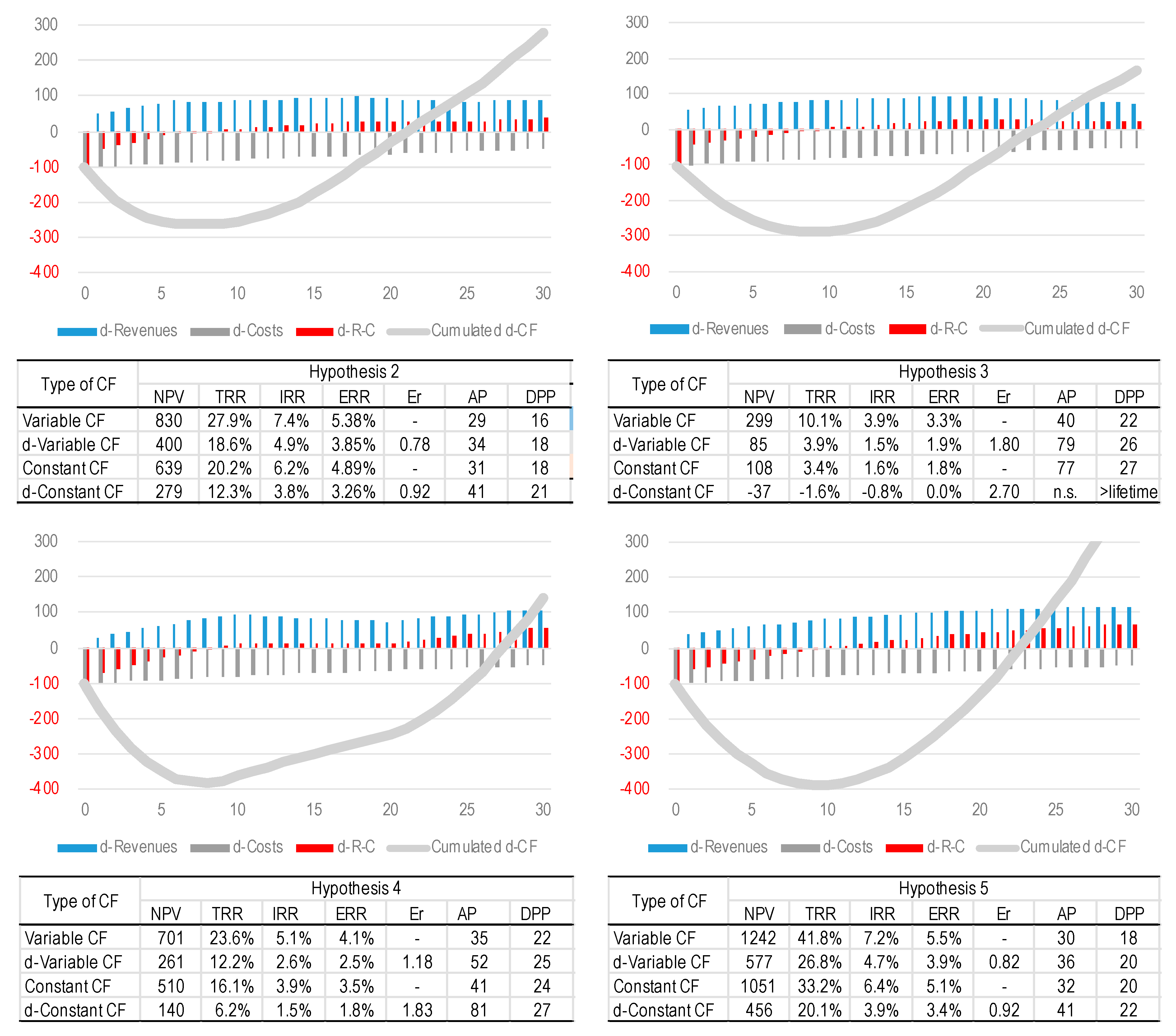
  • as first, the strategic role played by the stream of revenues and, indirectly, by the public recognition of the archaeological basin that should be created connecting the more strategic territorial values in an internally coherent landscape unit characterized by a strong identity,
  • as second, in order to better focus the following discussions, the difference between variable and constant cash flow, the former providing better results, thus the role played by the stockholders and, as a consequence, the impact of the interests of the amortizations,
  • as third—starting from the results above displayed providing a wide range of information—the complementary relation between profitability and risk that assumes a specific connotation in the field of the social capital and typically in the case of the cultural asset, as more in-depth discussed below.
These final multifaceted results, corresponding to different hypotheses of revenue dynamics, discounting, and costs distribution (with and without amortization) are the basis for the following critical interpretation of the economic-financial indices listed and compared above, in the prospect of supporting a future-oriented entrepreneurial behavioural pattern.

5. Discussions. The Economic-Financial Variables as Cultural and Social Communication Media
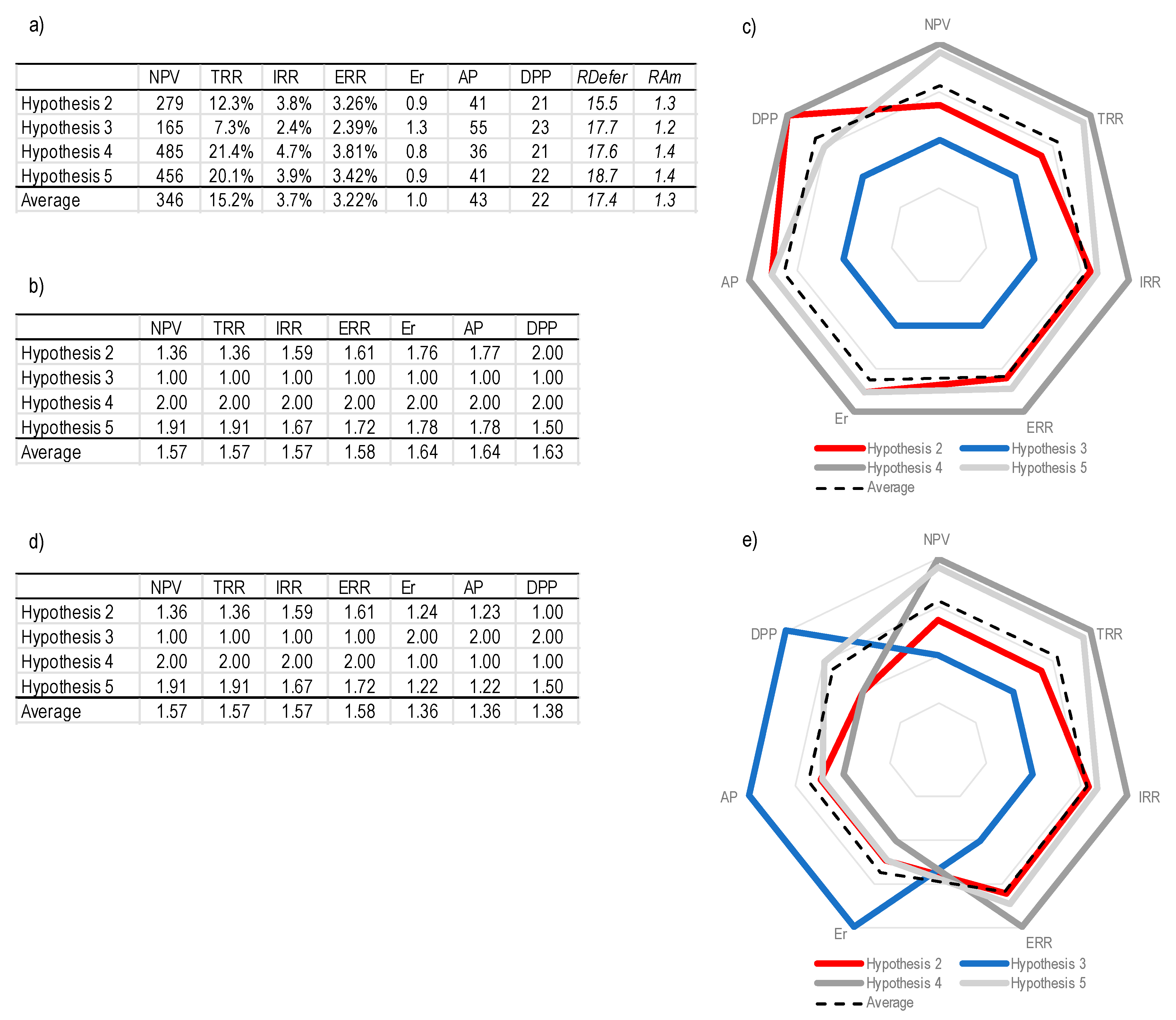
As anticipated, a detailed discussion on the results of this experiment integrating territorial, socio-economic and landscape communication, can be carried out by considering the multiple interpretations of each scenario from the perspective of the different type of indices. Between the four types of cash flows, only the discounted cash flows have been considered in this comparison, in order to take into account the impact of the interests included in the amortisations.
The comparison of the four scenarios has been carried out by normalizing the results and indices—expressed in different measurement units (EUR, percentage, years) (Figure 18a)—according to a standard scale of dimensionless scores (Figure 18b). A sort of “average scenario” has been outlined by calculating the average values of all the indices (18a) and scores (18b) in order to provide a benchmark for each of the four scenarios.
Two further final indexes have been calculated:
-
the “rate of deferral” ( R D e f e r ), calculated as the weighted average time of deferral of the revenues (second to the last column of the table in Figure 18a),
-
the “overall revenue amount rate” ( R A m ), calculated as the average multiplier of the revenue considered equal to 1 in the basic scenario (last column of the table in Figure 18a).
The discussion of these results proposes a comparison between the orthodox economic-financial approach and a possible heterodox perspective, the latter coming from the Keynesian and post-Keynesian financial speculative approach. Particularly, especially in the field of public economy, speculation needs to be assumed in its original meaning (excluding any ethical bias) mostly aimed at the monetary dynamics of a capital asset—basing on its risk/return profile—as well as the financial situation of the of players involved, that in this case define the social, cultural and political-administrative reference territorial framework.
Furthermore, although this DCFA experiment focuses on the goods and services that can be placed on the market, the economic-financial-monetary representation tool needs to be placed within a process that is triggered and guided by the political-administrative system as a consequence of a preliminary agreement between all the players involved, converging toward the logic of the “Cultural Asset Impact Investments”.
This approach is concretely applied here assuming the seven indices according to their specific economic, financial and monetary significance:
-
N P V and T R R can be considered as “economic” choice criteria whose significance concerns the amount of revenue and costs, and whose reference is the “opportunity cost of capital”,
-
ERR and IRR can be considered “financial” criteria whose significance mostly concerns the time allocation of revenues and costs, and whose reference are respectively the Minimum Acceptable Rate of Return ( M A R R ) and the discount rate,
-
E r , A P and D P P , mostly concerning the amount and at the same the deferral of the revenues (given the costs), although commonly considered as financial indices as well, have been here assumed as for their further “monetary” significance. This particular interpretation refers to the “propensity to expect” whose higher level typically characterizes low-risk or free-risk investments, such as the one developing in specific situations of complementarity and convergence of private and public interest, according to the concept of “social benefit”.
Figure 18 displays the comparison of the orthodox and heterodox approaches. The first one, synthesized in the radar graph of Figure 18c, shows the almost concentric placement and size of the four scenarios hypotheses within the indices polygon area and with respect to the aforementioned “average scenario”.
In such an interpretation, we notice that:
-
hypothesis 4 results the most profitable and sustainable mostly due to the highest value of R A m (1.4), despite the significant deferral ( R D e f e r = 17.6 ). Symmetrically, hypothesis 3 results the less profitable and sustainable mostly due to the lowest value of R A m (1.2), and the significant deferral ( R D e f e r = 17.7 ). Both hypotheses and the average layout are perfectly concentric,
-
the asymmetry of hypotheses 2 and 5 suggest a sort of complementarity of economic and monetary performances supporting some reflections about a possible heterodox approach.
Such an approach can be better discussed by assuming the deferral of the revenues as a positive value, once the ability of the public to guarantee the continuity of the project is recognized by the private player. As a consequence the monetary performances such as Elasticity ( E r ), Average Period ( A P ) and Discounted Payback Period ( D P P ) can be appreciated according to Figure 18d so that the ranking of the hypotheses changes according to the radar graph of Figure 18e.
As a result, two new asymmetries are highlighted: on the one hand the minor between hypotheses 2 and 4. On the other hand, the former poorest hypothesis 3 overcomes the average layout as well as hypothesis 2, and a more evident asymmetry in respect of all the other layout is highlighted. At the same time hypothesis, 4 is slightly preferable to the others.
Some final remarks highlight the main limitation of this research. A first limitation concerns the uncertainty of the costs of the project implementation, that could vary based on the more detailed description of the intervention area. A second uncertainty factor concerns the impact of the information and communication system (WebGIS and territorial marketing) on the shared knowledge of the activities promoting the archaeological-cultural basin.
Finally, the dialectic between the orthodox and heterodox interpretations could be more widely founded by detecting the integration of the private and public commitments in similar investments over the regional territory. Such a further study would provide basic information about of the amount of the marketable goods and services, in reference to the composition and the agreements between the private and public players about the budgeting and the cost allocation.

6. Conclusions

The conceptual premises of this project-valuation experiment, focus on the potential virtuous circle connecting research, experiencing and promoting in the perspective of increasing the scientific knowledge and public awareness of the cultural-territorial value. This work takes up the challenge of integrating the contemplative and cultural experience in the promotion of activities involving a composite set of public and private players.
This prospect outlines the conditions for hypothesizing that, despite the evidence of an orthodox economic approach, typically inspired by a microeconomic vision, the context feeds-back on the perception of profitability by the entrepreneurs involved in a more general “landscape impact investment” experience. In fact, a traditional approach inspired by the logic of environmental responsible investments (according to the Social Responsible Investments—SRI—approach [100,101]) focuses on the compatibility between private revenues and social benefits. In this case, instead, we envisaged actions, players and scales able to trigger a positive territorial impact (the end) basing on the individual economic cost-effectiveness (the means).
In fact, in such a project-decision context, mainly aimed at triggering local impact over a vast land area, this feed-back involves the decisions (concerning the expectations) as well as the underlying evidence (concerning the observations) that can be interpreted differently by the entrepreneurs according to the shared awareness to be part to an overarching socio-economic subject.
The convergence of natural evidence (the cultural landscape values) and cultural intentionality (the perspectives and prospects of players and users) encourage the individual entrepreneurial profiles to join giving rise to a territorial-economic unitary context where the sum of the individual choices creates a sort of collective intelligence typical of the social advanced communities.
In such a research area, a final remarkable issue concerning the achievements of evaluation science is the mutual causality—that is the expression of the two-way exchange of information –between valuation and project, surprisingly by means of economic-financial analysis when the project involves the cognitive/emotional individual/collective sphere of the land cultural asset.
In fact, whereas usually, the financial analysis holds creativity to the limitation of economic efficiency and financial feasibility, in this case, the collective project prospect, powered by the coordination of the landscape multiple dimensions, influence in turn the entrepreneurial creativity and the interpretation of the economic, financial and monetary indices.
According to the results of the economic analysis, further studies could be carried out in the field of operational research, thus transforming the aforementioned normalization of the indices in a Multi-Criteria Decision Making (MCDM) process involving the scores of the four scenario hypotheses, and the relative importance of each of them compared to the others, measured by a weight system. Furthermore, MCDM could be assumed as the communicative platform enveloping the whole cognitive, evaluative and creative process over which stake-holders and stock-holders meet combining and integrating cultural, professional and managerial resources: in this widened study context, the monetary abstraction would cover just a part of the whole decision-making path, actually involving the concrete values as the contents of specifically outlined value functions, and their relative importance according to an overarching weight system.
Typically, a weight system implements some theoretical assumptions coming from the constructivist philosophical approach, according to which the social reality—by definition, a linguistic elaboration—can be represented, and as a consequence constructed, as a result of an epistemic agreement between “standard observer” [102] (scientists). In an extended edition of this approach, influenced by pragmatism, the agreement involves social players converging toward shared objectives, thus prescinding from the truth. In fact, it should be noticed that the aforesaid agreement involves the programmes and the selective codes of conflicting and/or and cooperating social sub-systems. In general, such an extension values the predictive success, or at most, utility, that in the general context of land-urban policy, characterizes the programming approach based on standardized and shared communication patterns.
Accordingly, the landscape communication—here assumed as the final stage of the social abstraction of “things” in the “identity feeling” bringing together a settled community—can provide further social evidence for an economic-evaluation approach integrating the orthodox perspective (ordinary interpretation of the DCFA indices) and the heterodox prospect (valuing the extraordinary opportunity of a growing social agreement), thus highlighting the importance of the “monetary shape” [103] of the private-public investment. The monetary interpretation of the territorial development programmes takes into account and values the intertemporal communication [104], thus connecting further and further generations by means of the recognition of the settled communities’ ancient greatness, which is the primary and original shape of the social capital asset.

Author Contributions

Conceptualization, S.G., E.G., F.G. and C.M.; methodology, S.G. and F.G.; software, S.G., F.G. and C.M.; validation, S.G., M.R.T., C.M.; formal analysis, S.G. and M.R.T; investigation, E.G. and F.G.; resources, E.G., C.M. and F.G.; data curation, S.G. F.G.; writing—original draft preparation, S.G. G.N.; writing—review and editing, S.G., G.N. and M.R.T.; visualization, S.G., F.G. and G.N.; supervision, S.G., G.N., M.R.T.; project administration, S.G., E.G., F.G., C.M., G.N. and M.R.T. All authors have read and agreed to the published version of the manuscript.

Funding

This research received no external funding.

Conflicts of Interest

The authors declare no conflict of interest.

References

  1. Orbaşli, A. Archaeological Site Management and Local Development. Conserv. Manag. Archaeol. Sites 2013, 15, 237–253. [Google Scholar] [CrossRef]
  2. Ringbeck, B. The World Heritage Convention and Its Management Concept, Aspects of Management Planning for Cultural World Heritage Sites: Principles, Approaches and Practices; Springer International Publishing: Cham, Switzerland, 2017; pp. 15–24. [Google Scholar] [CrossRef]
  3. Frey, B.S.; Steiner, L. World Heritage List. In Handbook on the Economics of Cultural Heritage; Edward Elgar Publishing Ltd.: Cheltenham, UK, 2013; pp. 171–186. [Google Scholar] [CrossRef]
  4. European Commission. European Framework for Action on Cultural Heritage. 2018. Available online: https://ec.europa.eu/culture/library/commission-swd-european-framework-action-cultural-heritage_en (accessed on 31 January 2020).
  5. Rizzo, F. Nuova Economia; Aracne: Roma, Italy, 2013. [Google Scholar]
  6. Koens, K.; Postma, A.; Papp, B. Is Overtourism Overused? Understanding the Impact of Tourism in a City Context. Sustainability 2018, 10, 4384. [Google Scholar] [CrossRef] [Green Version]
  7. Thomas, B.; Langlitz, M. Archaeotourism, Archaeological Site Preservation, and Local Communities, Feasible Management of Archaeological Heritage Sites Open to Tourism; Springer International Publishing: Cham, Switzerland, 2018; pp. 69–78. [Google Scholar] [CrossRef]
  8. Sodangi, M.; Khamdi, M.F.; Idrus, A.; Hammad, D.B.; AhmedUmar, A. Best Practice Criteria for Sustainable Maintenance Management of Heritage Buildings in Malaysia. Procedia Eng. 2014, 77, 11–19. [Google Scholar] [CrossRef] [Green Version]
  9. Zhang, Y.; Li, X.R.; Su, Q. Does spatial layout matter to theme park tourism carrying capacity? Tour. Manag. 2017, 61, 82–95. [Google Scholar] [CrossRef]
  10. Giuffrida, S.; Trovato, M.R.; Giannelli, A. Semiotic-Sociological Textures of Landscape Values. Assessments in Urban-Coastal Areas. In Information and Communication Technologies in Modern Agricultural Development, Communications in Computer and Information Science; Salampasis, M., Bournaris, T., Eds.; Springer: Cham, Switzerland, 2019; Volume 953, pp. 35–50. [Google Scholar] [CrossRef]
  11. Giuffrida, S.; Trovato, M.R. A Semiotic Approach to the Landscape Accounting and Assessment. An Application to the Urban-Coastal Areas. In Proceedings of the 8th International Conference on Information and Communication Technologies in Agriculture, Food and Environment, HAICTA 2017, Chania, Crete Island, Greece, 21–24 September 2017; Volume 2030, pp. 696–708. [Google Scholar]
  12. Giannelli, A.; Giuffrida, S.; Trovato, M.R. Madrid Rio Park. Symbolic Values and Contingent Valuation; Valori e Valutazioni 21/2018, E-Flow Dei Tipografia del Genio Civile; 2018; pp. 75–85. Available online: https://siev.org/numero-21-2018/ (accessed on 20 February 2019).
  13. UNWTO. ‘Overturism’? Understandind and Managing Urban Tourist Growth beyond Perception. Available online: https://www.e-unwto-org/doi/book/10.18111/9789284420070 (accessed on 31 January 2020).
  14. Moira, P.; Mylonopoulos, D.; Kondoudaki, A. The Application of Slow Movement to the Tourism: Is Slow Tourism a New Paradigma? J. Tour. Leis. Stud. 2017, 2, 1–10. [Google Scholar] [CrossRef]
  15. Dickinson, J.E.; Lumsdon, L.; Robbins, D. Slow travel: issues for tourism and climate change. J. Sustain. Tour. 2011, 19, 281–300. [Google Scholar] [CrossRef]
  16. 2007–2013 Italia-Slovenia. Available online: http://2007-2013.ita-slo.eu/progetti/progetti_2007_2013/2010083015331456 (accessed on 4 May 2020).
  17. Zamparelli, G.; Del Gaudio, G. ‘Destination Branding’ di un Sistema Archeologico: Proposte per il Polo Pompeiano. Rivista di Scienze del Turismo 2011, 3, 131–136. [Google Scholar]
  18. Calderón, H.; Cervera-Taulet, A.; Molla, A. Brand assessment: A key element of marketing strategy. J. Prod. Brand Manag. 1997, 6, 293–304. [Google Scholar] [CrossRef]
  19. Cameron, C.; Rössler, M. Introduction of Management Planning for Cultural World Heritage Sites, Aspects of Management Planning for Cultural World Heritage Sites: Principles, Approaches and Practices; Springer International Publishing: Cham, Switzerland, 2017; pp. 3–13. [Google Scholar] [CrossRef]
  20. Blandford, C. Management Plans for UK World Heritage Sites: Evolution, lessons and good practice. Landsc. Res. 2006, 31, 355–362. [Google Scholar] [CrossRef]
  21. Holler, M.J.; Mazza, I. Cultural Heritage: Public Decision-Making and Implementation. In Handbook on the Economics of Cultural Heritage; Rizzo, I., Mignosa, A., Eds.; Edward Elgar Publishing Ltd.: Cheltenham, UK, 2013; pp. 17–36. [Google Scholar] [CrossRef]
  22. Trovato, M.R.; Giuffrida, S. A DSS to Assess and Manage the Urban Performances in the Regeneration Plan: The Case Study of Pachino. In Computational Science and Its Application ICCSA 2014; LNCS 8581; Murgante, B., Ed.; Springer International Publishing: Cham, Switzerland, 2014; Part III; pp. 224–239. [Google Scholar] [CrossRef]
  23. Trovato, M.R.; Giuffrida, S. The choice problem of the urban performances to support the Pachino’s redevelopment plan. Int. J. Bus. Intell. Data Min. 2014, 9, 330. [Google Scholar] [CrossRef]
  24. Guarini, M.R.; D’Addabbo, N.; Morano, P.; Tajani, F. Multi-criteria analysis in compound decision processes: The AHP and the architectural competition for the Chamber of Deputies in Rome (Italy). Buildings 2017, 7, 38. [Google Scholar] [CrossRef] [Green Version]
  25. Snowball, J.D. The Economic, Social and Cultural Impact of Cultural Heritage: Methods and Examples. In Handbook on the Economics of Cultural Heritage; Rizzo, I., Mignosa, A., Eds.; Edward Elgar Publishing Ltd.: Cheltenham, UK, 2013; pp. 438–455. [Google Scholar] [CrossRef]
  26. Della Spina, L.; Calabrò, F. Decision Support Model for Conservation, Reuse and Valorization of the Historic Cultural Heritage. In Computational Science and Its Applications—ICCSA 2018; Lecture Notes in Computer Science; Gervasi, O., Ed.; Springer: Cham, Switzerland, 2018; Volume 10962. [Google Scholar] [CrossRef]
  27. Trovato, M.R. A multi-criteria approach to support the retraining plan of the Biancavilla’s old town. In Smart Innovation, Systems and Technologies, 3rd International New Metropolitan Perspectives, 2018; Bevilacqua, C., Ed.; Springer: Cham, Switzerland; Reggio Calabria, Italy, 2019; Volume 101, pp. 434–441. [Google Scholar] [CrossRef]
  28. Elsorady, D.A. Adaptive Reuse Decision Making of a Heritage Building Antoniadis Palace, Egypt. Int. J. Arch. Heritage 2018, 14, 658–677. [Google Scholar] [CrossRef]
  29. Napoli, G.; Leone, M. The urban park as a “social island”. The ANP in the participatory project of Parco Uditore in Palermo. In Values and Functions for Future Cities, Green Energy and Technology; Mondini, G., Stanghellini, S., Oppio, A., Bottero, M., Abastante, F., Eds.; Springer International Publishing: Cham, Switzerland, 2019; pp. 229–248. [Google Scholar] [CrossRef]
  30. Napoli, G.; Giuffrida, S.; Trovato, M.R. Efficiency versus Fairness in the Management of Public Housing Assets in Palermo (Italy). Sustainability 2019, 11, 1199. [Google Scholar] [CrossRef] [Green Version]
  31. Hang, P.L.K.; Kong, C. Heritage management and control. J. Qual. Assur. Hosp. Tour. 2001, 2, 105–117. [Google Scholar] [CrossRef]
  32. Balaawi, F.A. Evaluating visitor management at the archaeological site of Petra. Mediterr. Archaeol. Archaeom. 2013, 13, 77–87. [Google Scholar]
  33. Young, C. Understanding management in a world heritage context: Key current issues in Europe. Hist. Environ. Policy Pr. 2016, 7, 1–13. [Google Scholar] [CrossRef]
  34. Apostolakis, A.; Jaffry, S. A choice modeling application for Greek heritage attractions. J. Travel Res. 2005, 43, 309–318. [Google Scholar] [CrossRef]
  35. Mazzanti, M. Cultural Heritage as Multi-Dimensional, Multi-Value and Multi-Attribute Economic Good: Towards a New Framework for Economic Analysis and Valuation. J. Socio-Economics 2002, 31, 529–558. [Google Scholar] [CrossRef]
  36. Bruyere, B.L.; Beh, A.W.; Lelengula, G. Differences in perceptions of communication, tourism benefits, and management issues in a protected area of rural Kenya. Environ. Manag. 2008, 43, 49–59. [Google Scholar] [CrossRef]
  37. Klamer, A. The values of cultural heritage. In Handbook on the Economics of Cultural Heritage; Rizzo, I., Mignosa, A., Eds.; Edward Elgar Publishing Ltd.: Cheltenham, UK, 2013; pp. 421–437. [Google Scholar] [CrossRef]
  38. Della Spina, L. Scenarios for a Sustainable Valorisation of Cultural Landscape as Driver of Local Development. In New Metropolitan Perspectives; ISHT 2018, Smart Innovation, Systems and Technologies; Calabrò, F., Della Spina, L., Bevilacqua, C., Eds.; Springer: Cham, Switzerland, 2019; Volume 100. [Google Scholar] [CrossRef]
  39. Seymour, E.; Curtis, A.; Pannell, D.; Allan, C.; Roberts, A. Understanding the role of assigned values in natural resource management. Australas. J. Environ. Manag. 2010, 17, 142–153. [Google Scholar] [CrossRef]
  40. Byrd, E.T. Stakeholders in sustainable tourism development and their roles: applying stakeholder theory to sustainable tourism development. Tour. Rev. 2007, 62, 6–13. [Google Scholar] [CrossRef]
  41. Alazaizeh, M.M.; Hallo, J.C.; Backman, S.J.; Norman, W.C.; Vogel, M.A. Value orientations and heritage tourism management at Petra Archaeological Park, Jordan. Tour. Manag. 2016, 57, 149–158. [Google Scholar] [CrossRef]
  42. Naselli, F.; Trovato, M.R.; Castello, G. An Evaluation Model for the Actions in Supporting of the Environmental and Landscaping Rehabilitation of the Pasquasia’s Site Mining (EN); ICCSA 2014, LNCS 8581; Murgante, B., Ed.; Springer International Publishing: Cham, Switzerland, 2014; Part III; pp. 26–41. [Google Scholar] [CrossRef]
  43. Vlami, V.; Kokkoris, I.P.; Zogaris, S.; Cartalis, C.; Kehayias, G.; Dimopoulos, P. Cultural landscapes and attributes of “culturalness” in protected areas: An exploratory assessment in Greece. Sci. Total. Environ. 2017, 595, 229–243. [Google Scholar] [CrossRef] [PubMed]
  44. Giuffrida, S. City as Hope. Valuation Science and the Ethics of Capital. In Green Energy and Technology; Mondini, G., Fattinnanzi, E., Oppio, A., Bottero, M., Stanghellini, S., Eds.; Springer: Cham, Switzerland, 2018; pp. 411–424. [Google Scholar] [CrossRef]
  45. Giuffrida, S. A Fair City. Value, Time and the Cap Rate. In Green Energy and Technology; Springer: Cham, Switzerland, 2018; pp. 425–439. [Google Scholar] [CrossRef]
  46. Conolly, J.; Lake, M. Geographical Information Systems in Archaeology; Cambridge University Press: Cambridge, UK, 2006; pp. 1–338. [Google Scholar] [CrossRef]
  47. Maatouk, M.M.H. Management of the preservation of heritage buildings using gis (the case of historic jeddah in Saudi Arabia). J. Eng. Appl. Sci. 2018, 65, 77–99. [Google Scholar]
  48. Tantillo, M.D. GIS application in archaeological site of solunto, International Archives of the Photogrammetry, Remote Sensing and Spatial Information Sciences—ISPRS Archives, Volume 36 (5/C53), 2007. In Proceedings of the 21st International CIPA Symposium 2007, Athens, Greece, 1–6 October 2007. [Google Scholar]
  49. Giuffrida, S.; Gagliano, F.; Napoli, G. Agriculture and Sustainability: A GIS Based Model to Appraise Incentive Policy. In Proceedings of the 7th International Conference on Information and Communication Technologies in Agriculture, Food and Environment (HAICTA 2015), Kavala, Greece, 17–20 September 2015; Volume 1498, pp. 912–921. [Google Scholar]
  50. Giuffrida, S. The True Value. On Understanding Something. In Appraisal: From Theory to Practice; Mondini, G., Fattinnanzi, E., Oppio, A., Bottero, M., Stanghellini, S., Eds.; Springer: Cham, Switzerland, 2016; pp. 1–14. ISBN 978-3-319-49675-7. [Google Scholar] [CrossRef]
  51. Eppich, R.; Grinda, J.L.G. Sustainable financial management of tangible cultural heritage sites. J. Cult. Herit. Manag. Sustain. Dev. 2019, 9, 282–299. [Google Scholar] [CrossRef]
  52. Wright, W.C.C.; Eppink, F.V. Drivers of heritage value: A meta-analysis of monetary valuation studies of cultural heritage. Ecol. Econ. 2016, 130, 277–284. [Google Scholar] [CrossRef]
  53. Giuffrida, S.; Trovato, M.R. From the Object to Land. Architectural Design and Economic Valuation in the Multiple Dimensions of the Industrial Estates; ICCSA 2017, LNCS 10406; Borruso, G., Cuzzocrea, A., Apduhan, B.O., Rocha, A.M.A.C., Taniar, D., Misra, S., Gervasi, O., Torre, C.M., Stankova, E., Murgante, B., Eds.; Springer: London, UK, 2017; Volume III, pp. 591–606. [Google Scholar] [CrossRef]
  54. Giuffrida, S.; Trovato, M.R.; Falzone, M. The Information Value for Territorial and Economic Sustainability in the Enhancement of the Water Management Process; ICCSA 2017, LNCS 10406; Borruso, G., Cuzzocrea, A., Apduhan, B.O., Rocha, A.M.A.C., Taniar, D., Misra, S., Gervasi, O., Torre, C.M., Stankova, E., Murgante, B., Eds.; Springer: London, UK, 2017; Volume III, pp. 575–590. [Google Scholar] [CrossRef]
  55. Napoli, G. The Value of the Useless in the Urban Landscape of Small Islands. In Proceedings of the 18th IPSAPA/ISPALEM International Scientific Conference: The Usefulness of the Useless in the Landscape Cultural Mosaic: Liveability, Typicality, Biodiversity, Catania, Italy, 3–4 July 2014; pp. 333–339. [Google Scholar]
  56. Giuffrida, S.; Trovato, M.R.; Circo, C.; Ventura, V.; Giuffrè, M.; Macca, V. Seismic Vulnerability and Old Towns. A Cost-Based Programming Model. Geosciences 2019, 9, 427. [Google Scholar] [CrossRef] [Green Version]
  57. Gabrielli, L.; Giuffrida, S.; Trovato, M.R. From Surface to Core: A Multi-Layer Approach for the Real Estate Market Analysis of a Central Area in Catania; ICCSA 2015, LCNS 9157; Gervasi, O., Murgante, B., Misra, S., Eds.; Springer: London, UK, 2015; Volume III, pp. 284–300. [Google Scholar] [CrossRef]
  58. Gabrielli, L.; Giuffrida, S.; Trovato, M.R. Functions and Perspectives of Public Real Estate in the Urban Policies: The Sustainable Development Plan of Syracuse; ICCSA 2016, LNCS 9789; Gervasi, O., Ed.; Springer: London, UK, 2016; Volume IV, pp. 13–28. [Google Scholar] [CrossRef]
  59. Gabrielli, L.; Giuffrida, S.; Trovato, M.R. Gaps and overlaps of urban housing sub market: a fuzzy clustering approach. In Appraisal from Theory to Practice, Green Energy and Technology; Stanghellini, S., Morano, P., Bottero, M., Oppio, A., Eds.; Springer: Cham, Switzerland, 2017; pp. 203–219. [Google Scholar] [CrossRef]
  60. Napoli, G. The complexity of value and the evaluation of complexity: social use value and multi-criteria analysis. In Integrated Evaluation for the Management of Contemporary Cities; Results of SIEV 2016, Serie: Green Energy and Technology; Mondini, G., Fattinnanzi, E., Oppio, A., Bottero, M., Stanghellini, S., Eds.; Springer International Publishing: Cham, Switzerland, 2018; pp. 187–198. [Google Scholar] [CrossRef]
  61. MIBACT, Ministero dei Beni e delle Attività Culturali e del Turismo, Ufficio Statistica, 2017. Available online: http://www.statistica.beniculturali.it (accessed on 4 May 2020).
  62. Regione Siciliana, Dipartimento dei Beni Culturali, 2018. Available online: http://www.regione.sicilia.it/beniculturali/dirbenicult/musei/museifruizione.html (accessed on 4 May 2020).
  63. Giannitrapani, E. Aspetti culturali e dinamiche del popolamento di età preistorica della provincia di Enna. Quaderni del Patrimonio Culturale Ennese 2012, 145–181. [Google Scholar]
  64. Giannitrapani, E.; Iannì, F. Tornambé, Pietraperzia, prov. di Enna—Campagne di scavo 2012–2013. Notiziario di Preistoria e Protostoria 2014, 1, 104–105. [Google Scholar]
  65. Giannitrapani, E.; Iannì, F. La tarda età del Rame nella Sicilia centrale. In Proceedings of the Atti della XLIII Riunione Scientifica dell’I.I.P.P., Bologna, Italy, 26–29 Novembre 2008; pp. 271–278. [Google Scholar]
  66. Giannitrapani, E. Dalla capanna alla casa. L’architettura domestica nella preistoria nella Sicilia centrale. In Mito e Archeologia degli Erei. Museo Diffuso Ennese: Itinerary Archeologici; Bonanno, C., Valbruzzi, F., Eds.; 2012; pp. 69–75. Available online: https://www.academia.edu/7596010/Mito_e_Archeologia_degli_Erei._Museo_Diffuso_Ennese_-_Itinerari_Archeologici_2012_ (accessed on 12 March 2018).
  67. Iannì, F. L’Eneolitico nella media valle del Salso. In Dai Ciclopi agli Ecisti: Società e Territorio Nella Sicilia Preistorica e Protostorica; Istituto Italiano di Preistoria e Protostoria: Firenze, Italy, 2012; pp. 1141–1143. [Google Scholar]
  68. Fragnoli, P.; Manin, A.L.; Giannitrapani, E.; Iannì, F.; Levi, S.T. Indagine archeometrica sulla tecnologia produttiva e la composizione della ceramica preistorica e protostorica di Tornambè (EN). In Proceedings of the Atti del VII Congresso Nazionale di Archeometria, Modena, Italy, 22–24 Febbraio 2012; pp. 137–149. [Google Scholar]
  69. Giannitrapani, E.; Iannì, F.; Pirrera, G. Indagini archeologiche e interventi di restauro del paesaggio antico nell’insediamento di età greca arcaica di Rocche a Pietraperzia (EN). Geologia dell’Ambiente 2015, 2, 64–77. [Google Scholar]
  70. Napoli, G.; Giuffrida, S.; Trovato, M.R. A Paradigm Interpreting the City and the Analytic Network Process for the Management of Urban Transformations; ISTH 2018; Bevilacqua, C., Calabrò, F., Della Spina, L., Eds.; Springer Science and Business Media Deutschland GmbH: Cham, Switzerland, 2019; Volume 100, pp. 672–680. [Google Scholar] [CrossRef] [Green Version]
  71. Evans, K.; Fielding, L. Giza (Egypt): The use of GIs in managing a World Heritage Site, Visitor Management; Taylor and Francis Inc.: Abingdon-on-Thames, UK, 2009; pp. 82–99. [Google Scholar]
  72. Aronoff, S. Geographic Information Systems: A Management Perspective; WDL Publications: Ottawa, ON, Canada, 1989; pp. 1–29. [Google Scholar]
  73. Van Orshoven, J.; Kint, V.; Wijffels, A.; Estrella, R.; Bencsik, G.; Vanegas, P.; Muys, B.; Cattrysse, D.; Dondeyne, S. Upgrading geographic information systems to spatial decision support systems. Math. Comput. For. Nat. Resour. Sci. 2011, 3, 36–41. [Google Scholar]
  74. De Meyer, A.; Estrella, R.; Jacxsens, P.; Deckers, J.; Van Rompaey, A.; Van Orshoven, J. A conceptual framework and its software implementation to generate spatial decision support systems for land use planning. Land Use Policy 2013, 35, 271–282. [Google Scholar] [CrossRef]
  75. Bica, I.; Tache, A.; Popescu, O.; Topoleanu, F.; Juganaru, G.; Tocanie, P.; Manole, S.D. Integrated Geospatial Type for Location and Protection of Archaeological Sites; Development Pilot Area: County Tulcea, Romania, 2008; pp. 361–366. [Google Scholar]
  76. Brovelli, M.A.; Magni, D. An Archaeological Web Gis Application Based on Mapserver and Postgis; International Archives of the Photogrammetry, Remote Sensing and Spatial Information Sciences—ISPRS Archives; Fangi, F., Malinverni, E.S., Eds.; IPSR: Portonovo, Ancona, Italy, 2003; Volume 34, pp. 89–94. [Google Scholar]
  77. Pareschi, M.T.; Stefani, G.; Varone, A.; Cavarra, L.; Giannini, F.; Meriggi, A. A geographical information system for the archaeological area of Pompeii. Geol. Soc. London Spéc. Publ. 2000, 171, 143–158. [Google Scholar] [CrossRef]
  78. Makuvaza, S. Aspects of Management Planning for Cultural World Heritage Sites: Principles, Approaches and Practices; Springer International Publishing: Cham, Switzerland, 2017; pp. 1–261. [Google Scholar] [CrossRef]
  79. Clark, K. Values in cultural resource management. In Heritage Values in Contemporary Society; Taylor and Francis: Abingdon-on-Thames, UK, 2017; pp. 89–99. [Google Scholar]
  80. Kountouri, E.; Benissi, C.; Papageorgiou, J. Management plans: A tool for participative decision-making. Internet Archaeol. 2018. [Google Scholar] [CrossRef]
  81. Benkari, N. Archaeological site of Bat-Oman, management and public perception: Community involvement in archaeological heritage management and planning. J. Cult. Heritage Manag. Sustain. Dev. 2018, 8, 293–308. [Google Scholar] [CrossRef]
  82. Trovato, M.R.; Nocera, F.; Giuffrida, S. Life-Cycle Assessment and Monetary Measurements for the Carbon Footprint Reduction of Public Buildings. Sustainability 2020, 12, 3460. [Google Scholar] [CrossRef] [Green Version]
  83. Giuffrida, S.; Ventura, V.; Nocera, F.; Trovato, M.R.; Gagliano, F. Technological, axiological and praxeological coordination in the energy-environmental equalization of the strategic old town renovation programs. In Values and functions for future cities. Green Energy and Technology; Mondini, G., Oppio, A., Stanghellini, S., Bottero, M., Abastante, F., Eds.; Springer: Cham, Switzerland, 2020; pp. 425–446. [Google Scholar] [CrossRef]
  84. RTLP. Available online: http://www.regione.sicilia.it/beniculturali/dirbenicult/bca/ptpr/LineeGuida.pdf (accessed on 3 April 2005).
  85. Provincial Landscape Territorial Plan (PTLP) as the Province of Enna Did. Available online: http://www.opendataterritorioenna.it/dati-scaricabili/ambiti-territoriali-del-p-t-p-r-piano-territoriale-paesistico-regionale-della-provincia-di-enna/ (accessed on 15 February 2019).
  86. Giuffrida, S.; Nocera, F.; Gagliano, F.; Trovato, M.R. Landscape Assessment and Economic Accounting in Wind Farm Programming: Two Cases in Sicily. Land 2018, 7, 120. [Google Scholar] [CrossRef] [Green Version]
  87. Giuffrida, S. The grammar of the house and of the city. Theoretical approaches for generating project. Valori e Valutazioni 2019, 23, 65–75. [Google Scholar]
  88. Giuffrida, S.; Gagliano, F.; Trovato, M.R. Identifying Archaeological Districts. A topology of the Landscape Values. Laborest 2019, 68–74. [Google Scholar]
  89. Napoli, G. Financial Sustainability and Morphogenesis of Urban Transformation Project. In Computational Science and Its Applications—ICCSA 2015; Gervasi, O., Murgante, B., Misra, S., Gavrilova, M., Coutinho Rocha, A.M.A., Torre, C., Taniar, D., Apduhan, B., Eds.; Springer International Publishing: Cham, Switzerland, 2015; Volume 9157, Parte III; pp. 178–193. [Google Scholar] [CrossRef]
  90. Nocera, F.; Giuffrida, S.; Trovato, M.R.; Gagliano, A. Energy and New Economic Approach for Nearly Zero Energy Hotels. Entropy 2019, 21, 639. [Google Scholar] [CrossRef] [Green Version]
  91. Giuffrida, S.; Ferluga, G.; Valenti, A. Capitalisation rates and ‘real estate semantic chains’: An application of clustering analysis. Int. J. Bus. Intell. Data Min. 2015, 10, 174. [Google Scholar] [CrossRef]
  92. Napoli, G.; Mamì, A.; Barbaro, S.; Lupo, S. Scenarios of climatic resilience, economic feasibility and environmental sustainability for the refurbishment of the early 20th century buildings. In Values and Functions for Future Cities, Green Energy and Technology; Mondini, G., Stanghellini, S., Oppio, A., Bottero, M., Abastante, F., Eds.; Springer International Publishing: Cham, Switzerland, 2019; pp. 89–115. [Google Scholar] [CrossRef]
  93. Valenti, A.; Giuffrida, S.; Linguanti, F. Decision Trees Analysis in a Low Tension Real Estate Market: The Case of Troina (Italy); LNCS 2015, 9157; Gervasi, O., Rocha, A.M.A.C., Murgante, B., Taniar, D., Apduhan, B.O., Gavrilova, M.L., Misra, S., Torre, C., Eds.; Springer: London, UK, 2015; pp. 237–252. [Google Scholar] [CrossRef]
  94. Napoli, G.; Giuffrida, S.; Trovato, M.R.; Valenti, A. Cap rate as the Interpretative Variable of the Urban Real Estate Capital Asset: A Comparison of Different Sub-Market Definitions in Palermo, Italy. Buildings 2017, 7, 80. [Google Scholar] [CrossRef] [Green Version]
  95. Giuffrida, S.; Ventura, V.; Trovato, M.R.; Napoli, G. Axiology of the Historical City and the Cap Rate. The Case of the Old Town of Ragusa Superiore; Valori e Valutazioni 18/2017, E-Flow Dei Tipografia del Genio Civile; 2017; pp. 41–55. Available online: https://siev.org/numero-18-2017/ (accessed on 4 May 2020).
  96. Trovato, M.R.; Giuffrida, S. The protection of territory in the perspective of the intergenerational equity. In Integrated evaluation for the management of contemporary cities. Green Energy and Technology; Mondini, G., Fattinnanzi, E., Oppio, A., Bottero, M., Stanghellini, S., Eds.; Springer: Cham, Switherland, 2018; pp. 469–485. [Google Scholar] [CrossRef]
  97. Giuffrida, S.; Gagliano, F.; Trovato, M.R. An Unconceivable Abstraction. The Archaeological Landscape and the Landscape Archaeology of the Erei Mount Chain, Italy. In Proceedings of the 21th IPSAPA/ISPALEM International Scientific Conference: Paradise lost of the Landscape-cultural Mosaic: Attractiveness, Harmony, Atarassia, Venice, Italy, 6–7 July 2017. [Google Scholar]
  98. Trovato, M.R.; Giuffrida, S. The Monetary Measurement of Flood Damage and the Valuation of the Proactive Policies in Sicily. Geosciences 2018, 8, 141. [Google Scholar] [CrossRef] [Green Version]
  99. Giuffrida, S.; Casamassima, G.; Trovato, M.R. Le norme EMAS-ISO nella valutazione della qualità del servizio idrico integrato. Aestimum 2017, 70, 109–134. [Google Scholar] [CrossRef]
  100. Capelle-Blancard, G.; Monjon, S. Socially Responsible Investing: It Takes More than Words. Available online: https://www.researchgate.net/publication/46455477_Socially_Responsible_Investing_it_Takes_More_than_Words (accessed on 5 March 2019).
  101. Junkus, J.; Berry, T.D. Socially responsible investing: A review of the critical issues. Manag. Finance 2015, 41, 1176–1201. [Google Scholar] [CrossRef]
  102. Maturana, H.; Varela, F. El árbol del Conocimiento; Rolf Behnchke Inscripción: Santiago, Chile, 1984. [Google Scholar]
  103. Rizzo, F. Dalla Rivoluzione Keynesiana Alla Nuova Economia. Dis-Equilibrio, Tras-Informazione e Co-Efficiente di Capitalizzazione; FrancoAngeli: Milano, Italy, 2002. [Google Scholar]
  104. Rizzo, F. Etica dei Valori Economici o Economia dei Valori Etici; FrancoAngeli: Milano, Italy, 2004. [Google Scholar]
Figure 1. Geographical location of the archaeological basin of Tornambé.
Sustainability 12 04022 g001
Figure 2. Ethno-anthropological and archaeological constraints in the Province of Enna, and the archaeological basin of Tornambé.
Sustainability 12 04022 g002
Figure 3. The general valuation-project communicative framework.
Sustainability 12 04022 g003
Figure 4. Example excerpts of the Geo-database (geographical references omitted).
Sustainability 12 04022 g004
Figure 5. The Archaeological basin of Tornambè: Geology.
Sustainability 12 04022 g005
Figure 6. The Archaeological basin of Tornambè: Geomorphology.
Sustainability 12 04022 g006
Figure 7. The Archaeological basin of Tornambè: Hydrology.
Sustainability 12 04022 g007
Figure 8. Historical territorial framework—IGM, 1865.
Sustainability 12 04022 g008
Figure 9. Intended uses.
Sustainability 12 04022 g009
Figure 10. Urbanization and road network.
Sustainability 12 04022 g010
Figure 11. Intervisibility map of Montegrande archaeological site.
Sustainability 12 04022 g011
Figure 12. Intervisibility map of Fastuchera archaeological site.
Sustainability 12 04022 g012
Figure 13. Summary and histogram of the main components of costs and revenues by policy and scale (EUR’000).
Sustainability 12 04022 g013
Figure 14. Variable and constant not discounted and discounted costs, revenues, annual and cumulated, cash flows (R-C) for the private player (SPV) over the 30y lifetime (abscissa: years; ordinate: EUR’000).
Sustainability 12 04022 g014
Figure 15. Cost allocation (EUR’000).
Sustainability 12 04022 g015
Figure 16. Revenue dynamics scenarios: (a) non-discounted layouts, (b) discounted layouts.
Sustainability 12 04022 g016
Figure 17. Economic-financial patterns of the discounted continuous cash flow of hypotheses 2–5. Tables: first column EUR’000; graphs: abscissa: years; ordinate: EUR’000.
Sustainability 12 04022 g017
Figure 18. Orthodox and heterodox interpretations of the economic, financial and monetary performances of the four scenarios. (a) Economic financial results. (b) Orthodox interpretation: normalization of the economic and financial indices. (c) Graphic comparison of the four scenarios according to the orthodox interpretation. (d) Heterodox interpretation: normalization of the economic and financial indices. (e) Graphic comparison of the four scenarios according to the heterodox interpretation.
Sustainability 12 04022 g018
Table 1. Framework of the project.
1. Territory2. Basin3. Site
1. ResearchGeo-Database/Web-GIS platform creationField survey of archaeological settlementExtension of the archaeological excavations
2. ExperiencingInformation customizable WebGIS tool packages for different users and institutions.
Coordination of these tools and development of the Geo-Database by including the pieces of information provided by the users
Maintenance of existing roads and development of cyclo-pedestrian paths. Riding school
Management of purchases of vehicles, tools, commodities Wine and food paths arrangement.
Expropriation of land areas and renovation of ancient country buildings.
Theatrical and recreational facilities.
Museum exhibitions and theatrical performances programming
3. PromotingDissemination of information through website, social media, tour operators, etc.
Attraction of tourists.
Commercial agreements on prices and tickets for standard and customized packages of services. Creation of the Archaeological Basin Brand integrating naturalistic trips, cultural experiences, cultural environmental education meetings, and food-wine events.
Archaeological, ethno-anthropological, botanical laboratories
Involvement of schools and University for training
Exhibitions or theatrical performances.
Musealization of the archaeological sites and finds.
Workshops.
Processing of information for the restoration of finds.
Restoration didactic laboratories
Table 2. Summary of the actions, revenues and costs of the archaeological research program.
PolicyScaleAreaActionItemAnnual RevenuesAnnual Costs
ResearchterritoryEnna Provincewebgis creationGIS professionals € 2321
website maintenanceGIS professionals € 6000
basinwhole basin surface archaeological researchdirector € 16,800
archaeologists € 37,800
GIS professionals € 1238
siteTornambèstratigraphy researchdirector € 12,000
archaeologists € 45,000
restorers € 12,000
GIS professionals € 6000
archaeological remains analyst € 1500
Montegrandestratigraphy researchdirector € 12,000
archaeologists € 45,000
restorers € 12,000
GIS professionals € 6000
archaeological remains analyst € 1500
Fastucherastratigraphy researchdirector € 12,000
archaeologists € 36,000
restorers € 12,000
GIS professionals € 6000
archaeological remains analyst € 1500
Anagargistratigraphy researchdirector € 12,000
archaeologists € 36,000
restorers € 12,000
GIS professionals € 6000
archaeological remains analyst € 1500
Table 3. Summary of the actions, revenues and costs of the cultural-contemplative experience program.
PolicyScaleAreaActionItemAnnual RevenuesAnnual Costs
ExperiencingterritoryEnna Provincearchaeological laboratoryfacilities € 7200
personnel € 15,000
€ 12,000
basinwhole basin accessibilityroadways
€ 7669
pedestrian roads € 8217
€ 20541
cycle paths € 5478
€ 8217
horse paths € 2739
€ 1369
Montegrandeparks20 cars park. area € 3492
Montecane2 buses 30 cars park. area € 5649
Rocche di Tornambèentertainment equipment50 seats theatre € 1833
€ 8400 € 8000
€ 3360
Masseria D’arrigorecreational equipmentproperty expropriation € 2,739
building renovation € 21,692
external area enhancement € 548
rent€ 30,600
Montegranderiding school, bicycle shelter, cateringcountry house renovation € 7669
depend. renov. (bike, stabl.) € 2629
riding school area renov. € 2739
property expropriation € 2739
rent€ 17,100
whole basin managementpersonnelpersonnel € 108,000
vehiclesall-terrain vehicles € 6222
materialssupplies € 2000
siteDonna Ricca - Rancititomaintenance, development, valorizationexpropriation of land € 234
necropolis cleaning € 274
road panel installation € 985
site panel installation € 59
Monte Canedevelopment, valorizationexpropriation of land € 148
panel installation € 394
Miniera di Monte Canemaintenance, development, valorizationexpropriation of land € 1,643
mine, scatt. houses recov. € 16,433
site area pedestrian paths € 411
panel installation € 1182
Fastucheradevelopment, protectionexpropriations, land use € 145
fencing € 548
Rocchemaintenance, development, valorizationexpropriation of land € 659
roads maintenance € 616
panel installation € 394
necropolis cleaning € 1096
Tornambèdevelopment, valorizationproperty expropriation € 329
ruins recovery € 3,287
photovoltaic panels€ 8333 € 5641
Anagargidevelopment, protectionexpropriations, land use € 2,028
fencing € 548
Sorgente Giorgiodevelopment, valorizationexpropriations, land use € 706
panel installation € 591
Montegrandemaintenance, development, valorizationexpropriations, land use € 769
panel installation € 1182
maintenance of the lane € 205
Table 4. Summary of the actions, revenues and costs of the promoting program.
PolicyScaleAreaActionItemAnnual RevenuesAnnual Costs
PromotingterritoryEnna Provinceterritorial marketingtour operators € 4000
Azienda Provinciale Turismo € 4000
editing € 6000
€ 4,000
tourist attraction € 6000
event organization (exhibitions, book presentations, etc.) € 6000
€ 3000
service packages organization € 2000
basinTornambèinternet web pageGIS professionals € 2000
whole basin botanical laboraroryexpropriation and use of land € 164
shelter € 1972
supplies € 2400
teachers € 2000
ordinary toursfull tickets
reduced tickets
guided tourstour guides trainer € 1575
tour guides refresher courses € 300
visits
audio guidesgps audio guide € 657
siteall sitesarchaeological tourism, archaeological laboratories, school campsteachers € 50,400
facilities € 3150
users€ 31,500
vehicles € 4200
tools € 420
shelter € 1200
supplies € 1050
director € 8400
archaeologists € 25,200
restorers € 16,800
GIS professionals and topographers € 16,800
archaeological remains analyst € 25,200
Table 5. Actions, revenues and costs of the promoting program.
Type of Cash Flow Hypothesis 1
NPV   ( EUR 000 ) T R R I R R E R R E r A P (years) D P P (years)
Variable cash flow60.2%0.3%1.89%-38929
Discounted Variable cash flow−39−1.8%−2.1%1.32%0.89n.s.>30
Constant cash flow−185−5.8%n.s.n.s.-7n.s.
Discounted Constant cash flow−161−7.1%n.s.n.s.0.115n.s.

