Promoting Sustainable Development of Cultural Assets by Improving Users’ Perception through Space Configuration; Case Study: The Industrial Heritage Site

 ,
,  ,
, 
 and
and 
Abstract
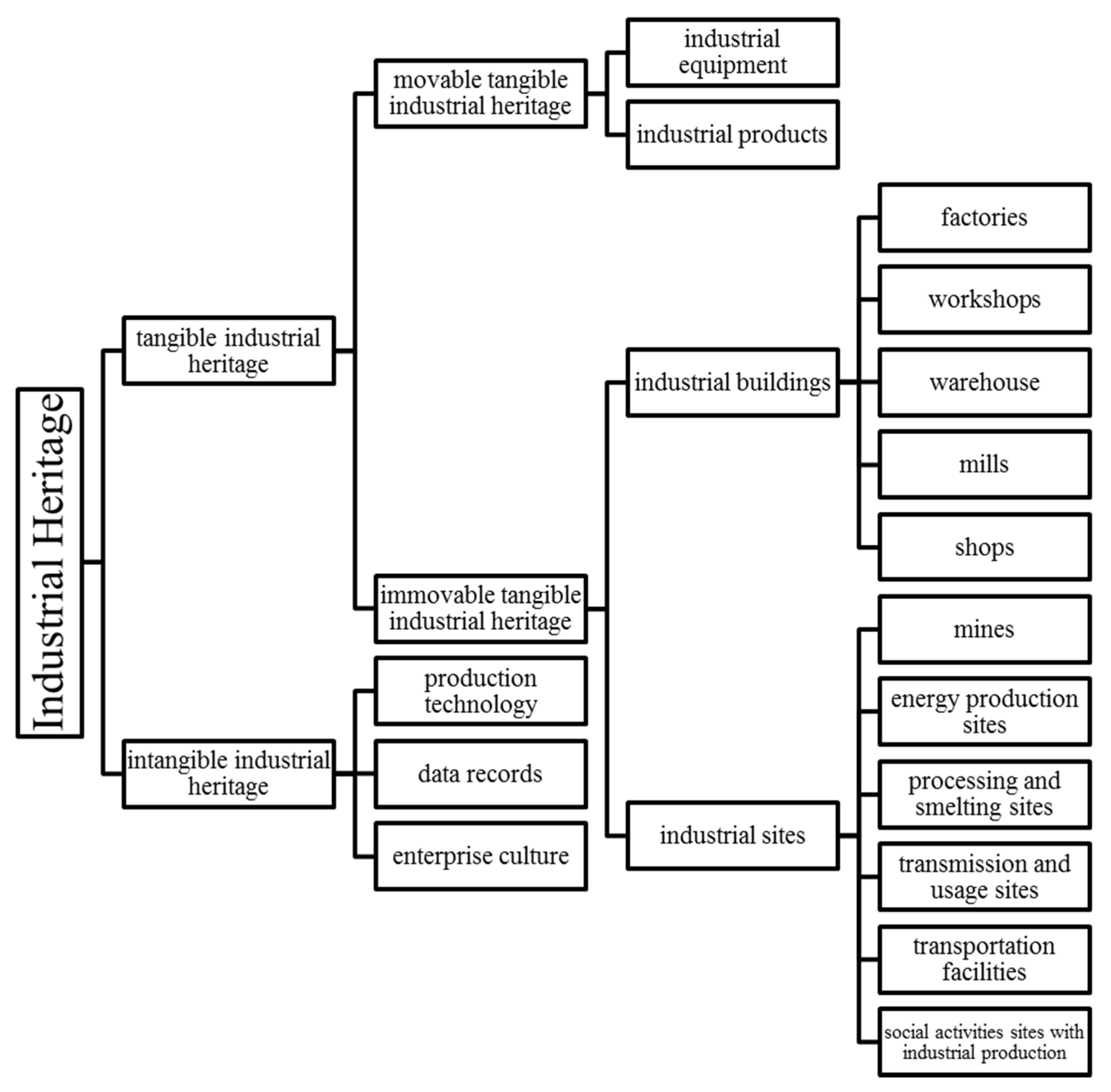
:1. Introduction
2. Materials and Methods
2.1. Research Background
2.2. Methodology
- questionnaire survey
- documentary coding
- interviews [42]
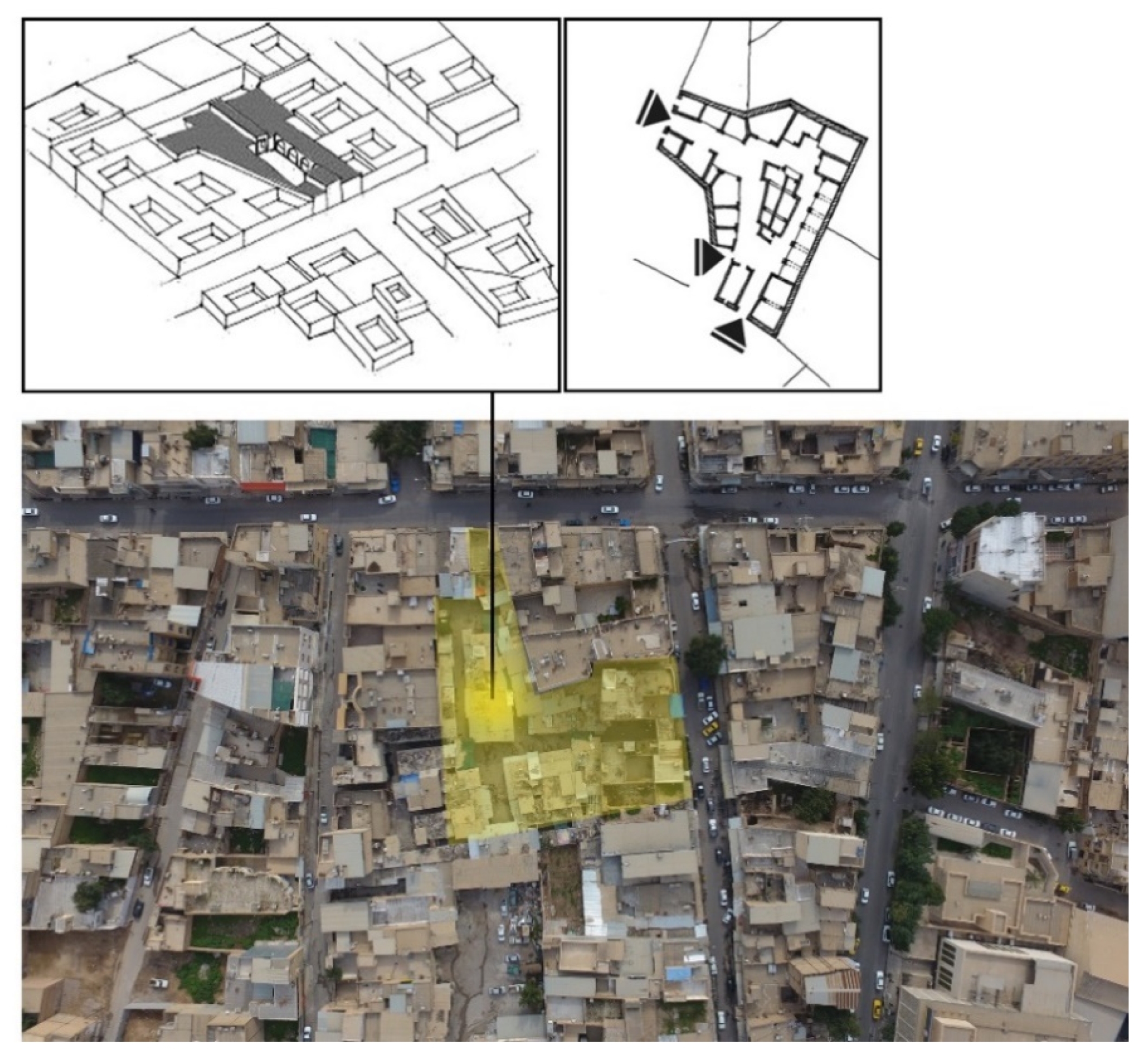
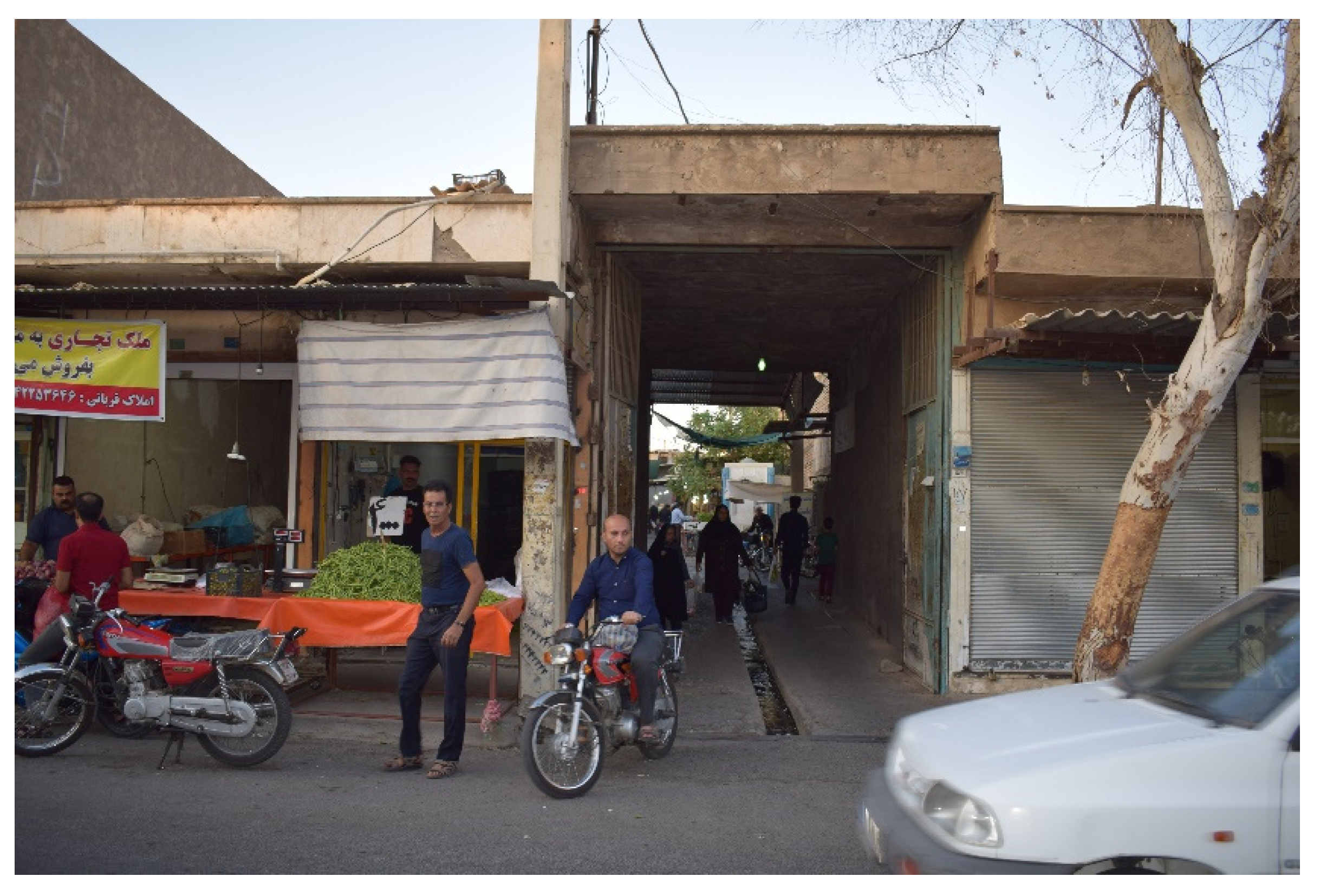
2.3. Research Scope and Case Study
- Historic value
- Technologic value
- Economic value
- Educational value
- Psychological value [54]
3. Results
4. Discussion
5. Conclusions
Author Contributions
Funding
Conflicts of Interest
Appendix A
| Questionnaire form | |||
| Description: This Questionnaire is carrying out as a part of research entitled “Promoting sustainable development of cultural assets by the enhancement of users’ perception through space configuration” in Dezful. This research is under the permission of Dezful’s municipality. | |||
| Procedure: The test begins with a brief verbal description of the complex. This description is classified into a route-type description, a survey-type (overview) description, similar to the classification of the questions. You will be then led to the test area. We highly encourage you to follow the guide through the predefined walking paths run through the complex for 10 min. Finally, you will be asked to fill the questionnaire out based on your previous experience in the complex. | |||
| Personal information: | |||
| Name and Surname: | Year of Birth: | ||
| Gender: | Highest Education: | ||
| Place of Birth: | Previous experience of this place: | ||
| Route-type questions: | |||
| 1. The starting point of the route is at the …. End of the complex | |||
| (a) Southern | (b) Western | (c) Southwestern | (d) Can’t remember |
| 2. After going through the gate, the first thing on your left is …. | |||
| (a) A grocery store | (b) A fruit shop | (c) A vegetable shop | (d) Can’t remember |
| 3. Just after entering the complex, there saw a relatively large empty space ….of you | |||
| (a) Left-hand side | (b) In front | (c) Right sand side | (d) Can’t remember |
| 4. Then, did you see two route-options? If so, which one did you choose? | |||
| (a) Yes, the left one | (b) Yes, the right one | (c) No, I didn’t see | (d) Can’t remember |
| 5. Did you turn to reach the corridor? If so, in which orientation? | |||
| (a) Yes, left | (b) Yes, right | (c) No, I didn’t turn | (d) Can’t remember |
| 6. In the corridor, what kind of shops did you see in the first shops? | |||
| (a) A grocery store | (b) A fruit shop | (c) A vegetable shop | (d) Can’t remember |
| 7. When did you see the large supermarket chain? | |||
| (a) near the entrance | (b) after the corridor | (c) before the corridor | (d) Can’t remember |
| 8. Where did you see the sewing shop? | |||
| (a) at the entrance | (b) at the end of the route | (c) at the left-hand side of the entrance | (d) Can’t remember |
| 9. How many turns did you make in your path? | |||
| (a) 0 | (b) 1 | (c) 2 | (d) Can’t remember |
| 10. The starting point of the route is at the …. End of the complex | |||
| (a) Southern | (b) Western | (c) Southwestern | (d) Can’t remember |
| Survey-type questions: | |||
| 11. The shape of the complex is … | |||
| (a) Rectangular | (b) Parallelogram | (c) curve shape | (d) Compound shape |
| 12. How many main areas are in this complex | |||
| (a) 4 | (b) 5 | (c) 6 | (d) Can’t remember |
| 13. Where is the facilities area? | |||
| (a) North region | (b) south region | (c) East region | (d) West region |
| 14. How many types of shops do you see in the complex? | |||
| (a) 4 | (b) 5 | (c) 6 | (d) 7 |
| 15. How many entrances this complex have? | |||
| (a) 2 | (b) 3 | (c) 4 | (d) Can’t remember |
| 16. How many empty spaces the complex have? | |||
| (a) 1 | (b) 2 | (c) 3 | (d) West region |
| 17. Where is the location of the supermarket chain? | |||
| (a) North region | (b) south region | (c) East region | (d) West region |
| 18. Where is the location of the sewing shop? | |||
| (a) Middle of the complex | (b) Southern region | (c) Western region | (d) Can’t remember |
| 19. What is the orientation of the corridor? | |||
| (a) South-North | (b) West-East | (c) Southwestern- Northeastern | (d) Can’t remember |
| 20. What is the function of the middle part? | |||
| (a) Shops | (b) Facilities | (c) Empty spaces | (d) Can’t remember |
References
- Chen, C. Study of the Hydraulic Landscape in Taoyuan Tableland: The Past, Present and Future. In Proceedings of the XVth International Congress of the International Committee for the Conservation of the Industrial Heritage, Taipei, Taiwan, 4–8 November 2012. [Google Scholar]
- King, T.F. The Archaeological Survey: Methods and Uses; Heritage Conservation and Recreation Service; U.S. Department of the Interior: Washington, DC, USA, 1978.
- Garagnanai, G.; Manferdini, A.M. Parametric accuracy: Building information modeling process applied to the cultural heritage preservation. In 3D-ARCH 2013; ISPRS: Trento, Italy, 2013; pp. 87–92. [Google Scholar]
- Nocca, F. The Role of Cultural Heritage in Sustainable Development: Multidimensional Indicators as Decision-Making Tool. Sustainability 2017, 9, 1882. [Google Scholar] [CrossRef] [Green Version]
- Avrami, E.; Mason, R.; De la Torre, M. Values and Heritage Conservation; Research Report; Getty Conservation Institute: Los Angeles, CA, USA, 2000. [Google Scholar]
- Porteous, J.D. Environment and Behavior: Planning and Everyday Urban Life Reading; Addison-Wesley: Boston, MA, USA, 1977. [Google Scholar]
- Duet, J. Industrial Heritage Retooled: The TICCIH Guide to Industrial Heritage Conservation; Routledge: Lancaster, UK, 2012. [Google Scholar]
- TICCIH. Taipei Declaration for Asian Industrial Heritage; TICCIH Press: Taipei, Taiwan, 2012. [Google Scholar]
- Van Oers, R. Identification and Documentation of Modern Heritage; UNESCO World Heritage Centre: Paris, France, 2003. [Google Scholar]
- Chang, D.; Penn, A. Integrated multi-level circulation in dense urban areas: The effect of multiple interacting constraints on the use of complex urban areas. Environ. Plan. B Plan. Des. 1998, 25, 507–538. [Google Scholar] [CrossRef] [Green Version]
- Lay, M.; Reis, A.; Dreux, V.; Becker, D.; Ambrosini, V. Spatial Configuration, Spatial Behavior and Spatial Cognition: Syntactic and Perceptual Analysis of the Market Station Area in Porto Alegre. In Proceedings of the EDRA 36, Vancouver, BC, Canada, 27 April–1 May 2005. [Google Scholar]
- Kim, Y.O. Spatial Configuration, Spatial Cognition and Spatial Behavior: The Role of Architectural Intelligibility in Shaping Spatial Experience, Bartlett School of Architecture, Building. Ph. D. Thesis, Environmental Design and Planning. University of London, London, UK, 1999. [Google Scholar]
- Abdelbaseer, A.M. Evaluating way-finding ability within urban environment. In Proceedings of the 8th International Space Syntax symposium, Santiago, Chile, 3–6 January 2012. [Google Scholar]
- Meilinger, T.; Franz, G.; Heinrich, H.B. From Isovist via Mental Representations to Behavior: First Steps Toward Closing the Causal Chain. Environ. Plan. B Plan. Des. 2012, 39, 48–62. [Google Scholar] [CrossRef] [Green Version]
- Hull, C.L. Principles of Behavior: An Introduction to Behavior Theory; Oxford publication: Oxford, UK, 1943. [Google Scholar]
- Tolman, E.C. Cognitive maps in rats and men. Psychol. Rev. 1948, 55, 189–208. [Google Scholar] [CrossRef] [PubMed] [Green Version]
- Hergenhahn, B.R.; Olson, M.H. An. Introduction to Theories of Learning; Pearson Prentice Hall: Upper Saddle River, NJ, USA, 2005. [Google Scholar]
- Bechtel, R.B.; Churchman, A. Handbook of Environmental Psychology; John Wiley & Sons Publisher: New York, NY, USA, 2002. [Google Scholar]
- Haq, S.U. Complex architectural setting: An investigation of spatial and cognitive variables through way finding behavior. Ph. D. Thesis, Georgia Institute of Technology, Atlanta, GA, USA, 2001. Unpublished. [Google Scholar]
- Makrí, M.; Folkesson, C. Accessibility measures for analyzes of land use and traveling with geographical information systems. In Proceedings of 2nd KFB-Research Conference, Lund, Sweden, 7–8 June 1999. [Google Scholar]
- Yohan, M.; Hwiyeol, J.; Jongin, K.; Jongin, R. Exploring Gender Differences in Spatial Orientation Ability on Representing Cognitive Map. Int. J. Psychol. Behav. Sci. 2016, 6, 91–98. [Google Scholar]
- Bada, Y.; Farhi, A. Experiencing urban spaces: Isovists properties and spatial use of plazas. Courr. Du Savoir 2009, 9, 101–112. [Google Scholar]
- Dosen, A.S.; Ostwald, M.J. Lived space and geometric space: Comparing people’s perceptions of spatial enclosure and exposure with metric room properties and isovist measures. Archit. Sci. Rev. 2017, 60, 62–77. [Google Scholar] [CrossRef]
- Xu, Y.; Rollo, J.; Jones, D.S.; Esteban, Y.; Tong, H.; Mu, Q. Towards Sustainable Heritage Tourism: A Space Syntax-Based Analysis Method to Improve Tourists’ Spatial Cognition in Chinese Historic Districts. Buildings 2020, 10, 29. [Google Scholar] [CrossRef] [Green Version]
- Turner, A. From axial to road-centre lines: A new representation for space syntax and a new model of route choice for transport network analysis. Environ. Plan. B Plan. Des. 2007, 34, 539–555. [Google Scholar] [CrossRef] [Green Version]
- Turner, A.; Doxa, M.; O’sullivan, D.; Penn, A. From isovists to visibility graphs: A methodology for the analysis of architectural space. Environ. Plan. B Plan. Des. 2001, 28, 103–121. [Google Scholar] [CrossRef] [Green Version]
- Tao, Y. Digital City and Space Syntax: A Digital Planning Approach. Planners 2012, 28, 24–29. [Google Scholar]
- Koohsari, M.J.; Sugiyama, T.; Mavoa, S.; Villanueva, K.; Badland, H.; Giles-Corti, B.; Owen, N. Street network measures and adults’ walking for transport: Application of space syntax. Health Place 2016, 38, 89–95. [Google Scholar] [CrossRef] [PubMed]
- Benedikt, M.L. To Take Hold of Space: Isovists and Isovist View Fields. Environ. Plan. B Plan. Des. 1979, 6, 47–65. [Google Scholar] [CrossRef]
- Batty, M. Exploring isovist fields: Space and shape in architectural and urban morphology. Environ. Plan. B Plan. Des. 2001, 28, 123–150. [Google Scholar] [CrossRef] [Green Version]
- Appleyard, D. Styles and methods of structuring a city. Environ. Behav. 1970, 2, 100–124. [Google Scholar] [CrossRef]
- O’Neill, M.J. Effects of signage and floor plan configuration on wayfinding accuracy. Environ. Behav. 1991, 23, 553–574. [Google Scholar] [CrossRef]
- Walker, J. Representing Social Space: Cognitive Mapping and the Potential for Progressive Urban Planning & Design. Trial Six Undergrad. Geogr. J. 2011, 5, 41–43. [Google Scholar]
- Papadopoulos, K.; Barouti, M.; Koustriava, E. Cognitive maps of individuals with blindness for familiar and unfamiliar spaces: Construction through audio-tactile maps and walked experience. Comput. Hum. Behav. 2017, 75, 376–384. [Google Scholar] [CrossRef]
- Lang, J. Creating Architectural Theory: The Role of the Behavioral Sciences in Environmental Design; Van Nostrand Reinhold Publisher: New York, NY, USA, 1987. [Google Scholar]
- Dalton, R.C.; Bafna, S. the Syntactical Image of the City: A Reciprocal Definition of spatial elements and spatial syntaxes. In Proceedings of the 4th International Space Syntax Symposium, London, UK, 17–19 June 2003. [Google Scholar]
- Blaut, J.M.; Stea, D. Mapping at the age of three. J. Geogr. 1974, 73, 5–9. [Google Scholar] [CrossRef]
- Golledge, R.G. Methods and methodologies issues in environmental cognition research. In Environmental Knowing; Moore, G.T., Golledge, R.G., Eds.; Dowden, Hutchinson and Ross: Stroudsburg, PA, USA, 1976. [Google Scholar]
- Kim, Y.O.; Penn, A. Linking the spatial syntax of cognitive maps to the spatial syntax of the environment. Environ. Behav. 2004, 36, 483–504. [Google Scholar] [CrossRef]
- Kitchin, R.M. Cognitive maps: What are they and why study them? J. Environ. Psychol. 1994, 14, 1–19. [Google Scholar] [CrossRef]
- Downs, M.R.; Stea, D. Image and Environment: Cognitive Mapping and Spatial Behavior; Edward Arnold: London, UK, 1973. [Google Scholar]
- Hwang, C.L.; Lin, M.J. Group Decision Making under Multiple Criteria Methods and Applications; Springer: Berlin/Heidelberg, Germany, 1987. [Google Scholar]
- Roberts, F.S. Discrete Mathematical Models with Applications to Social, Biological, and Environmental Problems; Pearson: London, UK, 1976. [Google Scholar]
- Steyvers, F.J.J.M.; Kooijman, A.C. Using rout and survey information to generate cognitive maps. Appl. Cogn. Psychol. 2008, 23, 223–235. [Google Scholar] [CrossRef]
- Appleton, J. The Experience of Landscape; Wiley: London, UK, 1975. [Google Scholar]
- Xiang, L.; Papastefanou, G.; Ng, E. Isovist indicators as a means to relieve pedestrian psycho-physiological stress in Hong Kong. Environ. Plan. B Urban. Anal. City Sci. 2020. [Google Scholar] [CrossRef]
- Dosen, A.S.; Ostwald, M. Evidence for prospect-reuge theory: A meta-analysis of the findings of environmental preference research. City Territ. Archit. 2016, 3, 4. [Google Scholar] [CrossRef] [Green Version]
- Peebles, D.; Mora, R. Effects of Geometry, Landmarks and Orientation Strategies in the “Drop-off” Orientation Task; International Conference on Spatial Information Theory: Berlin, Germany, 2007. [Google Scholar]
- Turner, A.; Penn, A. Making isovists syntactic: Isovist integration analysis. In Proceedings of the 2nd International Symposium on Space Syntax, Brasilia, Brazil, 29 March 1999. [Google Scholar]
- Casanelles, E.; Longunov, E. The Nizhny Tagil Charter for the Industrial Heritage; TICCIH XII International Congress: Moscow, Russia, 2003. [Google Scholar]
- Yang, H. A Study on Preservation, Restoration and Reuse of the Industrial Heritage in Taiwan: The Case of Taichung Creative Cultural Park. In Proceedings of the XVth International Congress of the International Committee for the Conservation of the Industrial Heritage, Taipei, Taiwan, 4–8 November 2012. [Google Scholar]
- ICOMOS. 17th General Assembly of ICOMOS; ICOMOS Press: Paris, France, 2011. [Google Scholar]
- Xu, Y.; Cao, Y. Cultural industrialization: A value realizing path for industrial heritage. Cross-Cultural Commun. 2012, 8, 104–107. [Google Scholar]
- Jie, G. the Protection and Renewal of Industrial Heritage from a Landscape Architect’s Perspective (A comparison between the Center of Norrköping and Xu Jiahui Park in Shanghai). Master’s Thesis, European Spatial Planning and Regional Development, Blekinge Instituted of Technology, Karlskrona, Sweden, 2009. [Google Scholar]
- Mahdavinejad, M.; Didehban, M.; Bazaz zadeh, H. contemporary architectural heritage and industrial identity in historic districts, case study: Dezful. J. Studies Iran. Islamic City 2016, 4, 41–50. [Google Scholar]
- Yanbin, Y. Towards the Methodology for the Reuse of Industrial Heritage in China. Ph. D. Thesis, Poly Technic University of Torino, Torino, Italy, 2014. [Google Scholar]
- Imamahwazi, M. Articles about Geographical History of Dezful; Dezful Publisher: Dezful, Iran, 2003. [Google Scholar]
- Afsharsistani, I. Survey about the Name of Iranian Cities; Rozane publisher: Tehran, Iran, 1999. [Google Scholar]
- Varoudis, T. DepthmapX Multi-platform Spatial Network Analysis Software. 2012. Available online: http://varoudis.github.io/depthmapX/ (accessed on 26 April 2020).


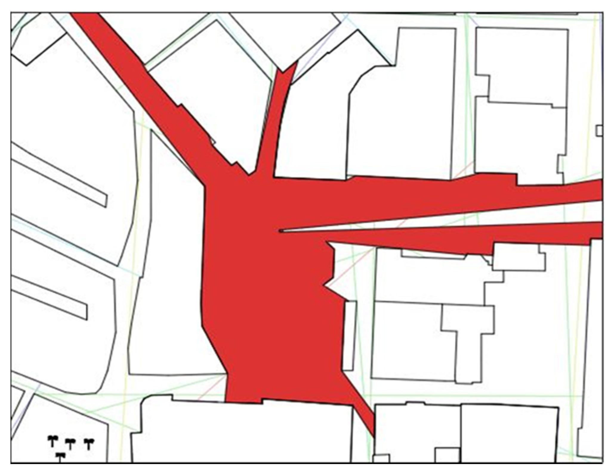
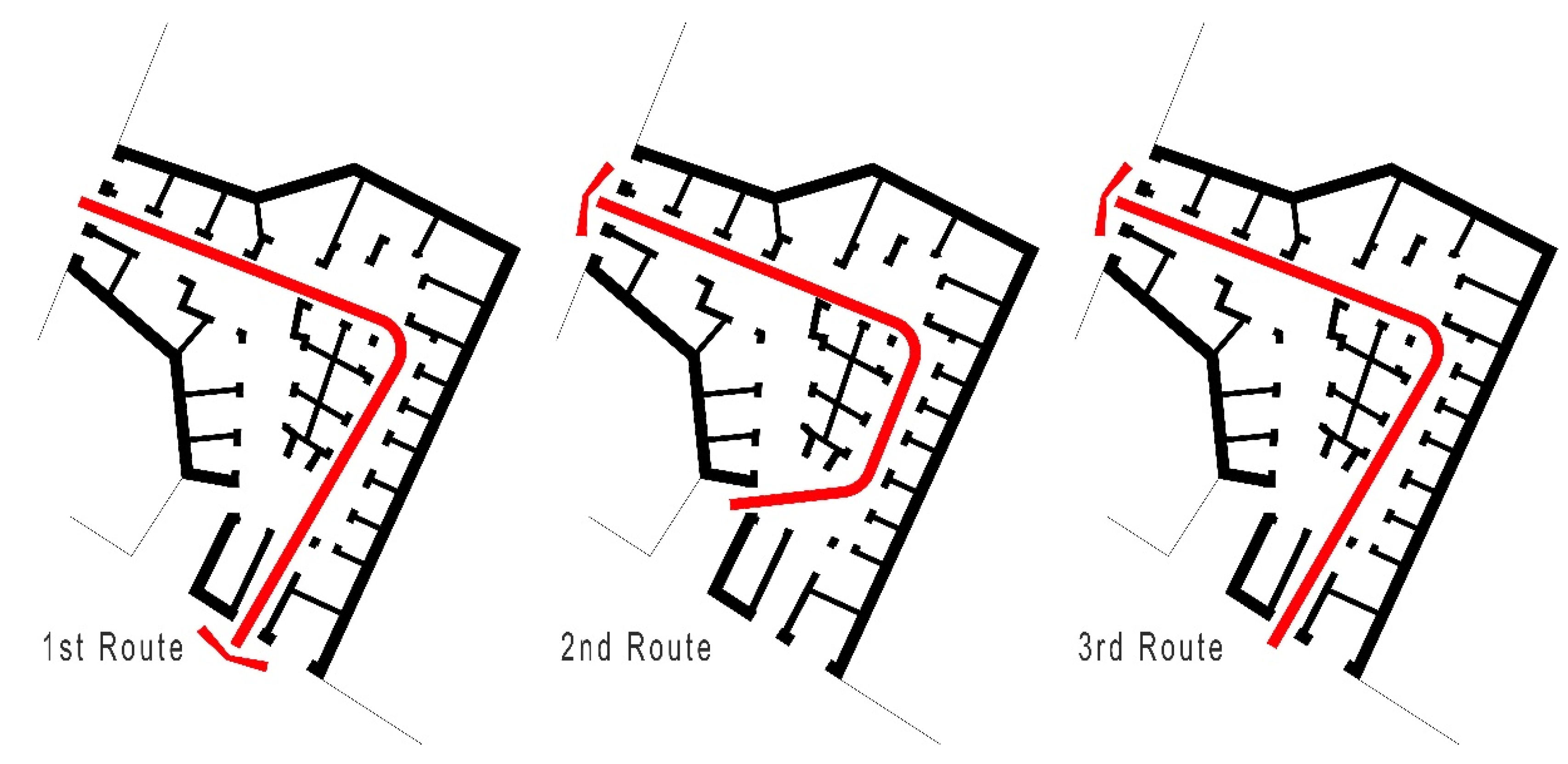
| Route | Length of Route (m) | Isovist Field | Entrance Visibility |
|---|---|---|---|
| First | 68 | 105.73 | 93.42 |
| Second | 55 | 89.52 | 62.76 |
| Third | 68 | 105.73 | 73.65 |
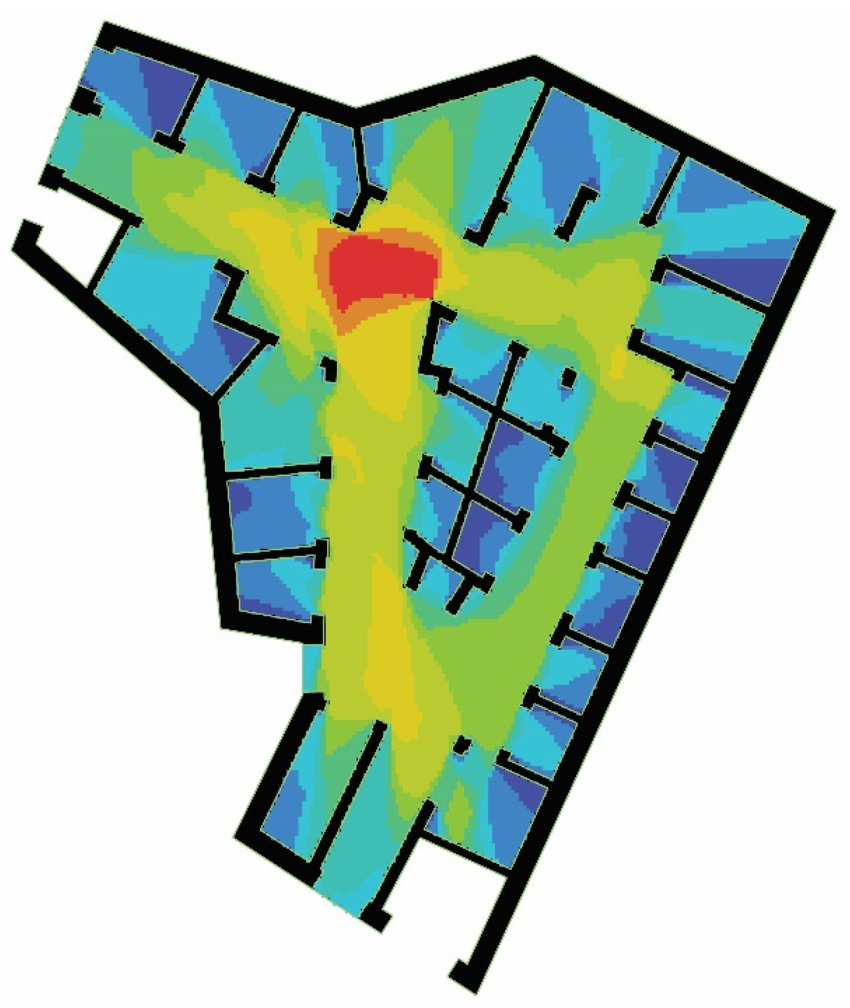
| Route | Length of Route (m) | No. of Interviewee | Maximum | Minimum | STDEV | Average |
|---|---|---|---|---|---|---|
| First | 68 | 30 | 83.63 | 48.5 | 15.32 | 71.4 |
| Second | 55 | 30 | 61.83 | 27.42 | 38.72 | 41.52 |
| Third | 68 | 30 | 86.28 | 43.73 | 21.63 | 62.25 |
| Examined Factors | V1 | V2 | V3 | |
|---|---|---|---|---|
| V1 | Users’ perception | 1 | 0.716 | 0.838 |
| Sig. (2-tailed) | - | 0.015 | 0.006 | |
| N | 90 | 90 | 90 | |
| V2 | Average Visibility | 0.716 | 1 | 0.582 |
| Sig. (2-tailed) | 0.015 | - | 0.035 | |
| N | 90 | 90 | 90 | |
| V3 | Visibility of entrance | 0.038 | 0.582 | 1 |
| Sig. (2-tailed) | 0.006 | 0.035 | - | |
| N | 90 | 90 | 90 | |
© 2020 by the authors. Licensee MDPI, Basel, Switzerland. This article is an open access article distributed under the terms and conditions of the Creative Commons Attribution (CC BY) license (http://creativecommons.org/licenses/by/4.0/).
Share and Cite
Bazazzadeh, H.; Nadolny, A.; Attarian, K.; Safar ali najar, B.; Hashemi safaei, S.s. Promoting Sustainable Development of Cultural Assets by Improving Users’ Perception through Space Configuration; Case Study: The Industrial Heritage Site. Sustainability 2020, 12, 5109. https://0-doi-org.brum.beds.ac.uk/10.3390/su12125109
Bazazzadeh H, Nadolny A, Attarian K, Safar ali najar B, Hashemi safaei Ss. Promoting Sustainable Development of Cultural Assets by Improving Users’ Perception through Space Configuration; Case Study: The Industrial Heritage Site. Sustainability. 2020; 12(12):5109. https://0-doi-org.brum.beds.ac.uk/10.3390/su12125109
Chicago/Turabian StyleBazazzadeh, Hassan, Adam Nadolny, Koorosh Attarian, Behnaz Safar ali najar, and Seyedeh sara Hashemi safaei. 2020. "Promoting Sustainable Development of Cultural Assets by Improving Users’ Perception through Space Configuration; Case Study: The Industrial Heritage Site" Sustainability 12, no. 12: 5109. https://0-doi-org.brum.beds.ac.uk/10.3390/su12125109