Advanced Techniques for Fast and Accurate Heritage Digitisation in Multiple Case Studies


Department of Architecture, University of the Basque Country UPV/EHU, Plaza Oñati 2, 20018 Donostia-San Sebastián, Spain
*
Author to whom correspondence should be addressed.
Sustainability 2020, 12(15), 6068; https://0-doi-org.brum.beds.ac.uk/10.3390/su12156068
Submission received: 30 June 2020
/
Revised: 16 July 2020
/
Accepted: 24 July 2020
/
Published: 28 July 2020
(This article belongs to the Special Issue Heritage under Threat: Digital Documentation, Preservation and Sustainable Management)
Abstract
:All elements of heritage are exposed to more or less predictable risks. Even though they are in a good state of conservation with economic support for their repair or maintenance, they can suffer sudden accidents leading to their imminent destruction. It is therefore necessary to safeguard them in all scenarios, regardless of the respective scale or state of conservation. That process must at least be based on complete and accurate 3D digitisation. The evolution of devices, software/hardware and platforms nowadays allows such information to be gathered in a sustainable manner. Various existing resources were tried and compared at several heritage sites of different scales with dissimilar risk and protection, following the guidelines of different ICOMOS (International Council on Monuments and Sites) committees. Each case study addresses the choice of digitisation techniques and the characteristics of the end product obtained. The most suitable modality for each situation is analysed, depending on different factors such as accessibility and risks faced. Although the 3D laser scanner is clearly a very fast and very accurate resource, automated photogrammetry is one of the more accessible and affordable resources; along with the potential of UAVs (unmanned aerial vehicles), this enables the digitisation to be sustainably completed.
1. Introduction
On 15 April 2019, the images of fire destroying the cathedral of Notre Dame in Paris were seen around the world. Other examples, such as the fire at the National Museum of Brazil in September 2018 [1], or the destruction of the Bāmiyān Buddhas in Afghanistan, helped raise immediate awareness about the fragile state of many heritage sites. The risks they face are, in many cases, unpredictable, sometimes intentional and sometimes accidental. However, in any case, such losses highlight the need to establish preservation strategies, which must begin with accurate and sustainable digitisation of the heritage asset. The aim is to generate replicas of the heritage asset via 3D models with as little investment and in as short a time as possible.
Even in the most well-conserved cases, such heritage assets face challenges of different natures which can become a real or hypothetical continual threat. A heritage asset may have sufficient economic backing to take care of maintenance and future renovations, yet in many cases it does not possess a thorough and accurate 3D model. The case of Notre Dame is a clear example of the lack of foresight in the building’s digital record. For this iconic Gothic cathedral, whose construction began in 1163 and ended in 1345 [2,3], there was no 3D digital model accurate enough to rebuild the features destroyed in the 2019 fire (the roof and spire, among others). Although there are three-dimensional captures of certain renovations using 3D laser scanning technology [4], they were never meant to provide a complete and accurate digital rendering to safeguard the asset in the future against eventual, sudden, unpredictable and catastrophic events with immediate and destructive impact. After the fire, the work done in 2010 by the Belgian art historian Andrew Tallon, is practically the only option that can be used to document the destroyed elements [5]. In 2010, a digital survey was conducted using a high-precision laser scanner, positioning the device at approximately 50 stations inside and outside the cathedral, obtaining 360° images that enabled the digital model to be mapped in colour, resulting in a quality model. However, the objective in this case was different; it was not meant to ensure effective and exact reconstruction in the wake of the disaster.
Architectural heritage is threatened by two categories of risks: the unpredictable ones and the predictable ones associated with the intrinsic features of the heritage asset. Disasters have occurred in fortuitous circumstances caused by humans or due to forces of nature, which can affect any heritage asset, even when in a good state of conservation with means to preserve it. However, other risks stemming from human action must not be forgotten, such as intentional destruction of heritage or heritage buildings threatened by rapid urban expansion of cities. It is estimated that more than 50% of the population lives in urban settlements and that in 2030, virtually 60% of people will live in cities [6,7]. The fast pace of global population growth means that they suffer from pressures of the property market, which demands free space to build more housing. However, the most obvious risk for heritage is probably the lack of means for the respective preservation and the deterioration over time due to aging and lack of maintenance.
It is hard to protect all heritage spread around the world to the same extent and at the same time. Some historic buildings and monuments are apparently at much more risk than others, so a scale of priorities must be established if the aim is to optimise resources to achieve effective and sustainable preservation [8]. However, even in cases without obvious risk, it is indispensable to have sufficient information on hand to preserve these heritage sites before they deteriorate or are destroyed. Digitisation can enhance understanding of the cultural heritage and respective values, while new tools enable better management and control of heritage as well as appropriate conservation. Moreover, publicising heritage via formats that actively explain its meaning and value helps raise public awareness; this is the surest way to preserve it. At present, the respective documentation should be based on obtaining a 3D model with sufficient textured geometric information, to which additional information (alphanumeric, video or virtual) can be added to ensure effective and sustainable preservation. To safeguard and protect in the long term, there are now state-of-the-art techniques based on massive point capture, enabling fast and accurate digitisation that can be adjusted to different economic circumstances, even when there is no management plan for the asset.
The main aim of the research was to try and to analyse different devices, software and platforms, both to capture the 3D reality and for dissemination or museum exhibition of the heritage to preserve. The latest market trends were worked with, especially modern automated resources that enable universal dissemination with open access as well as sustainable preservation and management of the heritage [9,10]. Several heritage sites of different scales were studied, with various protection levels and disparate degrees of conservation and risk. This was done following the guidelines of different scientific committees of ICOMOS (International Council on Monuments and Sites) and other international organisations devoted to disseminating the theory, methodology and technology applied to conserving, protecting and enhancing the value of cultural heritage. The pros and cons for each case were compared so that the most efficient workflow in each type of heritage asset analysed could be chosen.
It was verified that the particular constraints of each heritage asset generate unique problems that require the mastery of different resources with specific features, which in many cases must be used in a combined manner. Ultimately, it can be stated that modern non-invasive universal resources are available on the market, enabling a 3D model of the object analysed to be obtained quickly and with precision. This facilitates the sustainable preservation of any heritage element.
2. Materials and Methods
Bearing in mind the previously mentioned aim of the research, four heritage sites or monuments were chosen, situated in the Basque Country in southwest Europe, classifying them in three groups: heritage sites, heritage built of wood and heritage buildings embedded in the urban fabric. The selected heritage asset was described, indicating the risks it faces. Based on this problem, the kind of documentary record needed for each case could be determined. The purpose of the documentary record was also analysed, along with the choice of techniques most appropriate for each situation and the difficulties for the respective realisation.
2.1. Heritage Sites
The Managing Cultural World Heritage manual of UNESCO sets out basic guidelines for developing heritage management plans. Its central core provides a common framework for documenting heritage management systems, establishing a series of processes, among which data collection, including in monitoring processes, is fundamental. The manual warns that such systems must be able to deal with risks deriving from unpredictable events such as natural disasters or damage generated by human destructive action [11]. At the same time, the International Committee on Interpretation and Presentation of Cultural Heritage Sites (ICIP) of ICOMOS considers interpretation and presentation to be part of the overall process of conservation and management of cultural heritage, and establishes that graphic information sources should be based on systematic and detailed data analysis [12]. For all these reasons, the new digital techniques for data collection and three-dimensional rendering may, in coming years, become an indispensable tool for development of the processes that make up heritage site management systems [13].
Although the record from geographic information systems (GISs) already forms a part of such management systems, including digital terrain data, area demarcations, cadastral information, landscape types and accessibility, etc. [14], the new digital techniques hugely expand the operative scenario for data gathering, largely limited by the traditional tools—topographical instruments, photography, video and 2D/3D planimetrics.
Beyond reliable and comprehensive data collection, such records must be converted into information that can be integrated in a system accessible to all agents involved in the respective management [11]. In this regard, the last few years have witnessed the irruption of BIM (building information modelling) technology applied to the documentation of built heritage. Architects, along with archaeologists, conservationists and engineers, have considered this technology a disruptive force able to change the way that heritage is documented and administered [15]. Consequently, proposals based on collaborative HBIM (historical building information modelling) technology, accessible and interoperable via internet and enabling integration and management of indicators of different formats, have become increasingly common [16]. HBIM’s implementation is conceived as being an integrated process of information-gathering, 3D modelling and database design [17], wherein the capture of geometric information is established as a step prior to the modelling. In this regard, data acquisition using massive point-capture technology, which basically includes close-range photogrammetry and TLS (terrestrial laser scanner), resulted in an advance that has been extensively studied [18,19,20,21]. However, the dissemination in recent years of automated applications for planning and control of UAV (unmanned aerial vehicle) photography operations and the novel appearance of dynamic TLS-captures signifies a new enlargement of the panorama of the heritage documentation phase.
Salt Valley of Añana. World Heritage Candidate in 2013
The use of both data-capture techniques was studied in the Salt Valley of Añana, included in UNESCO’s indicative list of World Heritage candidates in 2013. The aim was to obtain a three-dimensional rendering of the site (3D shape reconstruction) as a step prior to the 3D modelling, enabling development of a BIM model to improve its management system.
The Salt Valley of Añana is one of Europe’s best conserved interior salt production complexes [22], recognised by the United Nations Food and Agriculture Organisation (FAO) as being Europe’s first Globally Important Agriculture Heritage System (GIAHS) (Figure 1). Since the first Salt Valley Master Plan was produced (2000–2004), its main goals have been to recover and conserve its material and environmental heritage, re-establish salt production using traditional and sustainable techniques, and develop initiatives that boost social, tourism-related and economic development of the region. The architecture of the salt evaporation beds, generated over centuries, has exceptional value owing to its adaptation to the site and because the original forms, functions, materials and techniques of traditional construction comprising this enormously rich sustainable heritage have been maintained [23].
The salt works encompass an area of approximately 15 ha, occupied by a group of wooden buildings in the form of stepped terraces that house the salt production beds, served by an intricate system of channels, shaping an exceptional and very geometrically complex landscape. Indeed, one of the main problems of the documentary process applied in the framework of the master plan was the use of a two-dimensional geographic information system [24] that was unable to depict that geometric complexity. The plan therefore required the production of a 3D Autocad model, for which it was necessary to collect and represent discrete data for three years. Due to it being a vector standard, this model does not permit interrelationship between geometric data and information during the monitoring process, thereby hampering the implementation of basic information: state of conservation, maintenance work, production, cultural and tourism impact, and environmental analysis, etc.
The study begins with the assumption that the combination of UAV data collection and the SfM (structure from motion) automated photogrammetry method facilitates heritage documentation due to the simplicity of the process and the extent of the working range [25,26]. The study centres on an assessment of the operability and effectiveness of the automated flight mode applied to taking photos via UAV and the novel appearance of dynamic TLS-capture in an environment where the complexity of the respective geometric configuration (extent of the group, multiplicity of elements and levels, pathway limits) makes it extremely difficult to capture data using photogrammetry techniques and TLS, which require instrument stationing. The UAV used is a DJI Phantom 4 pro model, equipped with a 20 Mpx effective CMOS 1” sensor and a focal distance of 35 mm, which reduces radial distortion and improves the metric quality of the SfM restitution method [27]. The UAV is controlled by a programmable application (DJI-GS Pro), which enables configuration of the flight mission by means of navigation based on satellite positioning (GNSS).
With the aim of documenting the entire group of salt work structures, as well as part of the surrounding area, a grid composed of 44 square sectors measuring 71 m per side with an area of 0.5 ha was created, establishing a low-altitude (20 m) flight parameter to ensure accuracy of the model (Figure 2a) [28]. This altitude provides a GSD (ground sampling distance) factor of 0.5 cm/pixel with 75% frontal and lateral overlap between photos. Using a Leica TCR 407 total station, four ground control points (GCPs) were established per sector in UTM (Universal Transverse Mercator) coordinates, using 35 × 35 cm targets. The CPGs were positioned based on the following criteria: First, the placement of targets 1, 2, 3 and 4 on the edges of each sector, close to the vertices of the delimiting square, ensuring the greatest possible distance between them in the XY plane; second, their staggered arrangement with respect to the Z axis, trying to ensure the maximum possible elevation difference between targets 1 and 4 and locating the other targets 2 and 3 equidistantly. This was done to guarantee the highest horizontal and vertical precision of the model [29].
Bearing in mind the need for accurate documentation of the vertical structural supports and masonry walls that support the wooden frameworks on which salt is produced, and considering that the exclusive use of nadir shots offers less precise results, particularly in geometric description of the vertical planes [30], the use of nadir shots (Gimbal angle of −90°) and oblique shots (Gimbal angle of −45°) was combined. One nadir shot and four oblique shots were thus done per sector, with the latter aligned to the four trajectories that join the vertices of each sector with its centre (Figure 2b,c).
Due to the extremely difficult access, and the narrowness and the low clearance of many of the spaces situated under the salt evaporation beds, data collection using photogrammetric techniques or TLS that require tripod stationing is practically undoable. The capture of the pillars, beams and structural frameworks hidden under the beds was therefore done using a Leica BLK2GO hand scanner, just released on the market in 2020. This 3D laser scanner captures images and point clouds in motion and real-time, using SLAM (simultaneous localisation and mapping) technology to record its course through the space [31,32,33]. The scanner combines double-axis LiDAR, a 4.3 Mpx 360° panoramic viewing system, a 12 Mpx high-resolution camera for detailed photos and an inertial measurement unit that enables self-navigation, capturing 420,000 pts/s, with a capture range of 0–25 m. The performance of the system based on SLAM technology offers relative precision of 6–15 mm and absolute positioning precision of 20 mm for maximum scans of 2 min (Figure 3).
Four itineraries of less than two minutes were executed, computing a course with a total length of 75 m in a previously delimited area of 0.125 ha, the aim being to determine the equipment’s performance with respect to scanning range and power and thereby evaluate the method’s operability (Figure 4).
2.2. Heritage Built of Wood
In its principles for conservation of heritage built of wood, the ICOMOS International Committee on Wood (IIWC) recognises the importance of the documentary process to tackle the increasing loss of historic wooden structures due to their vulnerability to climate conditions, natural and specific to the surroundings, and to the destructive action of humans. It also highlights the importance of educational programmes for awareness, recognition and understanding of the respective values and cultural significance. The new digital techniques for three-dimensional geometric rendering and visual depiction may help minimise the effects of that vulnerability and prove to be fundamental in policies meant to conserve and sustainably develop that heritage [34].
Despite its small territorial extent, the Basque Country retains substantial heritage built of wood, comprising the carpentry work used in the structures, frameworks and ceilings of nearly a hundred churches and several hundred farmsteads [35,36,37]. Some authors have highlighted the singular nature of Basque carpentry, not just in the Spanish and French context [36,38] but also as the repository of a very archaic tradition in the European scope [39]. The origin of this wooden heritage was traditionally situated in a period between the end of the 15th century and the first half of the 16th century [40], coinciding with the territory’s pacification [41,42] and its profound urban transformation [43]. Some investigations have corroborated this idea, dating such structures to the first half of the 16th century [44]. However, recent research has indicated dates that go back to the mid-15th century [45], proposing a revision of the historiographical bases.
Despite the recognition, protection and awareness of some paradigmatic examples [46], this is a very vulnerable heritage, threatened by multiple factors and basically characterised, in the case of the churches, by disuse and vacancy caused by the secularisation of the Catholic religion [47]. Additionally, the numerous examples, their dispersal in the territory and the system governing privately owned property make it very hard to manage plans and investments that guarantee effective protection of such heritage. To that vulnerability must be added the general lack of an accurate documentary record of geometric and dimensional nature that could support the asset’s reconstruction in the event of an unpredictable disaster or accident.
An example of three-dimensional rendering (3D shape reconstruction) is shown, using digital techniques applied to the polychrome wooden frame covering the interior of the church of San Andrés de Ibarrangelua in Biscay.
The Church
The Basque Autonomous Community concentrates more than 60 examples of churches with aesthetic ceilings of wood or charpente apparente [48] in an area of just over 1600 km2. The origin of these ceilings is associated to the scant financial means available to many rural temples to cover their chapels with stonework vaults, so they had to use wood [35]. Barring occasional exceptions, most cases are situated in modest parish churches or chapels in small settlements far from major urban centres and main communication arteries. They are generally buildings without continuous use. Hence, in most cases, this is a hidden heritage, barely known and insufficiently valued by society. Moreover, the high degree of territorial dispersal and their location outside the main tourism routes makes it hard to generate financial income; this is a major inconvenience that hinders efforts to revert this situation. All this makes it a heritage group with a high degree of vulnerability.
The church of San Andrés de Ibarrangelua is one of the most representative examples of this heritage. It counts a large polychrome wooden frame that covers the inside of the five-section nave, divided by four large diaphragm arches (Figure 5a). The ensemble displays a rich and very striking polychrome repertoire in which iconographic elements from Christian tradition and Italian Mannerist adornment are represented (Figure 5b).
Considering that close-range photogrammetry allows geometric recording of the heritage asset at low cost and an acceptable level of accuracy [49] and that the graphic environments of virtual and immersive reality can improve accessibility, awareness and understanding of the respective values [50], it was decided to apply that methodology for the purpose of achieving three specific objectives:
- To establish a low-cost working method that is not technically complex, with a high degree of automation;
- To record and document the heritage asset in order to have a geometric digital model that supports its conservation;
- To boost awareness and knowledge of heritage values by means of graphic depiction techniques based on virtual representation and immersive experience.
A Nikon D3400 photographic camera with a CMOS sensor, 23.5 mm × 15.6 mm, 24.2 effective Mpx was used, with a Nikon AF-S Nikkor f/1.8 G objective. The SfM processing software used was ReCap Photo, with option to make use of the free educational licence for free processing of up to 100 photos and the paid licence for processing up to 300 photos.
Taking into account the size of the study object (30 × 14 m), the photo shoot was divided into five rectangles, each corresponding to one of the vaulted sections covering the nave, with each rectangle measuring approximately 6 × 14 m. The photo shoot was arranged using, as a reference, the parameters of average focus distance (10 m) and overlap between consecutive shots (horizontal/vertical 60%). Each rectangle was thus divided into a grid with an interval of 1.5 m that determines the stationing of each shot. Based on that grid, five static sequences were done using a tripod: one orthogonal shot sequence and four 45° oblique shots, perpendicular to the four sides that define each of the rectangles (Figure 6). A total of 200 photos were thus obtained for each vaulted section and 1000 photos in all, providing a ratio of 2.38 photos/m2. Using a Leica TCR 407 total station, two GCP control points were established for each of the vaulted sections at local coordinates, using as reference, characteristic features of the vaults’ polychrome work, with the aim being to scale the photogrammetric model. The static photo shoot was completed with a series of UAV-captures that enable detailed orthogonal depictions of the polychrome work situated on the vertical planes of the diaphragm arches.
Considering that virtual reality, 3D graphics and digitised objects no longer require any expensive equipment or specialised viewing hardware [51], after processing the photoset and obtaining a textured 3D digital rendering model (3D shape reconstruction), it was implemented in various formats accessible to the non-specialised public. The opportunities offered by virtual viewing web platforms were specifically studied, along with multiplatform viewing formats such as interactive PDF3D or viewing systems included in OS operating systems such as the interactive 3D viewer of Microsoft Windows 10.
2.3. Heritage Buildings Embedded in the Urban Fabric
Each typological case study of heritage has its concrete risk, though there is one common problem that affects those heritage buildings that have become constricted with the urban fabric due to urban expansion caused by the increasing population. As this is a common issue that affects the whole world, it impacts buildings diversely, depending on their intended use and, above all, on the kind of ownership maintained. Social and economic change requires more and more buildable ground, and real estate pressure, above all, places buildings at risk that are not publicly owned. Within this common block, two very different cases will be studied, which affect the choice of methodology for the capture of reality in 3D: a 16th-century religious building converted into a museum and a 20th-century industrial building.
2.3.1. 20th Century Industrial Heritage: The Case of NCO (Nueva Cerámica de Orio)
The Basque Country is one of the most important industrial zones in western Europe. Its location next to France on the Cantabrian coast, the existence of iron deposits and the strategic port of Bilbao have made it a reference in steelmaking. The Vizcaya Bridge, also called the Hanging Bridge of Portugalete, declared by UNESCO to be part of the World Heritage, is one example of Industrial Revolution iron architecture [52,53]. Along with this important industry, other production sectors such as textiles, paper and metallurgy have also developed. In the province of Gipuzkoa, a mountainous coastal region, industry was dispersed among urban centres some distance from each other. Their location was strongly influenced by the area’s orography, with chains of mountains surrounding the flat areas along valley floors [54]. This specificity entails a number of associated risks.
The doctrine of the International Committee for the Conservation of the Industrial Heritage (TICCIH), which advises ICOMOS, highlights the importance of cataloguing, recording and researching industrial remains whose preservation is sought, stressing the need to protect them by taking sufficiently strong legal measures. Construction pressure nevertheless generates a lack of protection for many such buildings (Table 1). The abundance of industrial buildings with heritage or architectural value makes it impossible to economically sustain such spaces [55]. The legal protection of some factories safeguards them in the first instance, though their disuse leads to much deterioration.
The demographic increase places these industrial buildings at risk. On the one hand, factories and workshops originally situated outside towns have become embedded in the urban fabric, and their coveted location means they are in danger. On the other, there is the risk of only protecting buildings with architectural value, demolishing the industrial complexes they pertain to. As expressed by the Nizhny Tagil Charter, these isolated buildings lose the value of being the “evidence of activities which had […] profound historical consequences” [56]; only the aesthetic value is maintained, due to the quality of their architecture. This decontextualisation considerably lowers the industrial heritage value and impacts the public appeal and interest. It must not be forgotten that the heritage value of these industrial complexes reflects social habits that make up the culture of the place [56].
The case selected for this comparative study manifests one of the problems mentioned. It is the Nueva Cerámica de Orio (NCO) factory, situated between a fluvial channel and a national highway on the outskirts of a small coastal town (Figure 7). The municipality’s urban expansion absorbed the lot where it was situated, leaving it totally constricted. This complex, formed by the factory, offices and laboratory, enjoys general protection; the factory is the building with the most architectural value [57]. The machinery is preserved, as well as the brick furnaces and chimneys, and the production process is easily understandable. The usual production of refractory material ended some time ago, though the building continues to be used as a warehouse. It enjoys a high degree of protection, but is still a high-risk heritage asset due to acceleration of its progressive deterioration. The flooded roof is not sufficiently impermeable, whereby water penetrates the building and runs along the façades. The old steel windows (very much used at the time) are rusted, and the process has sped up deterioration of the façades. The objective of the digitisation work is consequently linked to the need for an urgent and absolutely necessary intervention.
All these pathologies have resulted in a building whose morphology has changed compared to the original edifice. Unlike the previously indicated cases, this is not about undertaking an exhaustive digital survey of the asset in its current state, as there is no interest in preserving the deformations it presents, which, in many cases, measure several centimetres. The aim is to preserve the values of the original construction, and, for that purpose, repair and renovation will be necessary. Exhaustive data collection should therefore be accompanied by a restoration based on documentary study of the building. The research was able to obtain the project drawings produced in 1941; they are still well-preserved and are an indispensable tool for studying and understanding the building, even though evident differences between the plan and what was eventually built have been verified.
The NCO is privately owned, with scant resources to maintain or invest in it, and is open to real estate interests that could enable its renovation and reuse. For all these reasons, the preservation of the heritage asset by means of a fast and accurate digital survey is indispensable, although there are barely any financial means for such an undertaking. The digital documentary record aims to define a 3D BIM consistent with its original state, for subsequent repair of the building, and to achieve exhaustive documentation of the current state, accurately compiling the pathologies to determine which elements must be replaced and which repaired. Considering the second aim, above all, for restoration of the façades, it was deemed necessary to obtain textured 2D scale elevations, which will enable collapses and other pathologies to be studied. The digital survey was completed by the collection of video and photographic data to completely document the heritage asset, as the building presents areas of difficult visual access.
The geographical features, the current use linked to a large accumulation of material inside, the lack of financial resources and the sorry state of conservation conditioned the techniques to use (Table 2 and Table 3). Given the complexity of the model used and the diverse parameters affecting it, a survey was conducted in various phases, combining different techniques.
In the first phase, a direct capture of specific points was produced, with total station, laser distance measurement and sketch done on site (Figure 8a). For this purpose, a Leica Geosystems model TCR-407 total station was used. The work was done with typical deviation parameters (ISO 17123-4) with 5 mm + 2 ppm prism (IR), using a global coordinate system. Due to the difficult access to many points, the measurement was finished with a Leica D2 laser measurement device with typical measurement precision of ±1.5 mm at 10 m. This enabled a reliable base to be obtained, in order to begin producing the BIM model. In the second phase, a survey was conducted using automated photogrammetry, using both the Nikon D-3400 digital camera and the Phantom 4 Pro UAV employed in previous work (Figure 8b,c). These buildings situated in the urban fabric have an added complexity when using UAVs, because, in many cases, the buildings are founded in zones catalogued as CTR (controlled airspace), an extensive reserved control area around airports so that take-off and landing operations can safely proceed. In such areas, express permission from the responsible authority is required. In this case, the building is outside the CTR and also counts an extension of private land east of the plot which allows the UAV to take off and land in total security. The capture flights were done both inside and outside the building. Inside, the flight was done in A mode, with the indispensable skill of the pilot to fly with precision between the accumulated elements and manually take the photos to be used in the 3D photogrammetric survey (Figure 8b). Outside, the flights were done in P mode with GPS, which allowed automated flights with pre-set photogram captures to be programmed, executed with precision in a very short time.
The possibility of using the 3D laser scanner was studied, producing a scanning plan over a plan of the complex. The building’s characteristics greatly hindered the work, and it was considered that an incomplete job would be obtained at high financial cost, making it an operation unsustainable for private property. Its effective use was therefore ruled out.
2.3.2. San Telmo, a Convent Converted into a Public Museum in the City’s Historic Centre
The example selected for this analysis is the Museum of San Telmo, a 16th-century religious monastery converted into a museum and situated in the historic centre of San Sebastián [58]. The building’s most important values consist of features built in sandstone exposed to continuous wear caused by the saline environment. It is a building that experiences a major flow of people due to its use as a museum. It nevertheless has an effective management plan and presents a perfect state. It might be said that it is not at risk of either real estate pressure or lack of maintenance, though it is not immune from suffering a fortuitous and unexpected fatal incident. Indeed, the building’s cloister suffered some damage in the citywide fire of 1813 and part of the original ashlar vaults have been replaced by plaster replicas suspended from a concrete framework. That intervention is not in line with the principles of the ICOMOS charter for analysis, conservation and restoration of architectural heritage structures [59]. According to the recommendations of that charter, to preserve such elements in the future, there is an obvious need for effective collection and processing of data in order to determine an integral action plan, analysing the problem of the structural elements in stone [60]. Additionally, the need to understand the structure’s evolution from its original to its current state is indicated, with the indispensable compilation of a detailed record of the asset. Furthermore, the International Scientific Committee on Risk Preparedness (ICORP) emphasises “the growing capacity of science and technology to enable the conservation and rehabilitation of cultural heritage” [61]. It is therefore necessary to make an inventory of heritage assets before possible disasters, as ICORP stipulates.
The building was originally a 16th-century monastery in which the cloister and the church stand out (Figure 9a). The large and narrow plot is squeezed between a street and a hillside with very steep slopes. The typology, therefore, had to adapt and presents singularities such as, for example, the rhomboidal form of the floor plan. The proportions of the church space or the latticework of the cloister’s ground floor date to the Renaissance, while the latter’s vaults and the construction solutions in general still pertain to the Gothic. In the 19th century, it was declared a national monument and placed under state protection. In 1928, the Provincial Monuments Commission made the decision to restore the complex and turn it into a museum. In 2004, an expansion project was developed, and in 2011, the new Museum of Society and Citizenship opened (Figure 9b and Figure 10). It is, therefore, a renovated building, much visited, which counts planning and sufficient financial backing to be managed and maintained by part of the public administration. It is also one of the city’s oldest entirely preserved buildings. Apart from the obvious differences, we stand before a case similar to that of Notre Dame, as San Telmo is not immune from suffering a fortuitous accident like what happened in the 1813 fire. Even after the recent expansion, it does not have a complete and accurate textured 3D model that could safeguard the heritage site against an unexpected disaster.
Although there are financial means for its preventive maintenance, in early 2019, when the 3D digital survey was conducted, the public ownership was not aware of the need to record a comprehensive model of the entire recently renovated building, whereby the work only covered parts of the property that were deemed of greater interest.
The cloister area was basically captured with precision, although to place it in context, transition elements were collected. During the first stage, singular elements of the cloister such as the arches or vaults were also captured, and during the second stage, the external surroundings were also captured, including nearby buildings and Mount Urgull (Figure 11).
Bearing in mind that the museum is under controlled airspace in a historic centre, strict authorisations are required. This aspect, along with the fact that it abuts the southeast face of the hill, where, in addition, the GPS signal is weak, led to the exterior UAV flight being ruled out. They were only used in manual mode for the building’s interior, to obtain detailed photos of inaccessible areas of the cloister’s arches and vaults, and to make a continuous detailed video flight of the ground floor gallery of the cloister. The massive point capture was therefore achieved mainly with a 3D laser scanner. For that purpose, three devices of the Leica Geosystems brand were tried, with different characteristics that are more or less suitable depending on the singularities of each proposed objective.
In the first stage, to capture part of the building, the RTC360 and the BLK360 (F11a) were used (Figure 12a). Recently introduced on the market, they stand out for three features: they are extremely light, there is no need to waste time on levelling, and they capture 360° spherical images in HDR in a short time, generating a cloud of colour points. They can also be linked to the Cyclone FIELD 360 application using a tablet or mobile phone to keep recording and relating scans as the work is carried out in the building. The RTC360 has a recording range of up to 130 m, which can entirely cover this building. Its measurement rate reaches 2 million points/second, which can be completed in two minutes. It is especially interesting from the efficiency standpoint, because it counts VIS technology, enabling it to record automatically and without targets the device’s movement from one scanning point to another, so that the partial point clouds are recorded in a spatial location related to the other scans, thereby facilitating the office work. The building’s scanning plan was made taking this device’s features into account. The work started with an exterior scan in the square east of the building, from which the museum is accessed. A total of 19 scans were completed, focusing, above all, on capturing the cloister in detail. The BLK360 has a recording range of 60 m, collecting 360,000 points/second. Although this device is cheaper to rent than others, more time would have to be spent, because it requires more scans and more in-office processing time than the other scanners used. Actually, its use would not be needed if the RTC360 is available, though it does have a couple of singular features that make it very interesting. It has a 360° thermal camera that is very useful with respect to sustainability and energy efficiency for work associated to maintenance or facility management, and it is very small and only weighs 1 kg, so it could be easily raised by hand to capture hidden points at heights of over 2 m in the area of the vaults.
In the second stage, the ScanStation P40 was used, with a range of up to 270 m and a scan speed of 1 million points/second. In this case, its use was of interest to capture the external surroundings of the museum, including nearby buildings and the hill the building abuts (Figure 11). This P40 scanner is older than the ones mentioned above, though it does have some interesting advantages for other kinds of work; it also has disadvantages that can slow down this specific survey. On the one hand, each scan point must be levelled with a great deal of precision, although, in interiors, this process can be facilitated using a wheeled base (Figure 12b). On the other hand, the scanner weighs more than 12 kg, and to move it from one scan point to another, it is recommendable to take it off the tripod. Finally, the 360° image capture option is not as efficient as in the other two models. If the intention is to obtain a coloured point cloud, an external digital camera perfectly calibrated in height is used (Figure 12c). It was therefore possible to capture the hill and surrounding buildings using few scans in a black-and-white cloud to optimise working times.
Although the public administration does not see the need to obtain an accurate 3D model, the work carried out, besides producing a textured 3D model, enabled the research to address two aspects of interest for this building: the obtaining of a BIM model for sustainable management and maintenance of the museum, and the possibility of building replicas of stone elements by means of advanced manufacturing.
3. Results
3.1. Salt Valley of Añana
Data collection by means of UAV-assisted close-range photogrammetry, organised using flight control and planning software, enables a digital terrain model to be obtained for the entire Salt Valley complex, using, for that purpose, less than 48 actual flight hours. This implies a very substantial cost reduction compared to those using data collection by means of static photogrammetry techniques and TLS, which require instrumental stationing (Table 4).
Given the size of the intervention area, the programming of flight missions enables more efficient management of the photo-taking process. This allows, with the necessary periodicity, repetition of the photo shoot, reproducing the flight itinerary and altitude, alignment, position and number of shots. The methodology is thus adjusted to the UNESCO Managing Cultural World Heritage guidelines for the monitoring phase, as it is a systematic methodology that minimises the subjectivity of the data collection process, allowing repetition and comparison in time [11].
This procedure does not offer a sufficiently precise geometric description of very slender features, such as the structural supports at the edges of the salt production platforms, and it evidently does not enable capture of the set of structural elements hidden under those platforms.
The use of a hand scanner with SLAM technology enables completion of the digital model obtained using UAV-assisted close-range photogrammetry, facilitating the recording of geometry of limited or hidden access. It was thus possible to describe the geometry of the hidden wooden structures (poles, beams and joists) (Figure 13). The linkage of different itineraries allowed an area of 0.125 ha, including those hidden spaces, to be recorded in eight minutes (Figure 14 and Figure 15). A scanning estimate for the entire Salt Valley complex was made, computing a total of 28 h of actual scanning (Table 5).
3.2. Heritage Built of Wood
The Church of San Andrés de Ibarrangelua
Given the size of the selected example and considering that most churches that comprise this heritage group are much smaller, the method and procedure used can be extrapolated in its application to any of the churches in the group.
A three-dimensional digital model was obtained in the form of a textured three-dimensional mesh exportable in FBX, OBJ, STL, PLY and PTS formats (Figure 16a,b). The export via PTS format enabled the generation of point clouds linkable using ReCap PRO (Autodesk) software with educational licence in RCP format (Figure 16c). This format enables export of the model to the REVIT (Autodesk) software with educational licence, as a step prior to generating a BIM model. The heritage asset’s documentation is thus enabled through different operating environments for management of the 2D and 3D graphic information. This information can be shared thanks to the free collaborative Autodesk Viewer, without the need to install any kind of software.
By exporting in OBJ format, the textured digital model was implemented in the repository of 3D Sketchfab objects, which by means of WebGL technology enables orbiting around the model in real- time, using any common browser and mobile device (Figure 17). Bearing in mind that this resource enables the embedding of complementary information in the model, in the form of URL links, text, image and video, the model was complemented with detailed photos, obtained by UAV, of some of the most significant polychrome work (Figure 17). Using a practically automated process of the application, the model was configured so it could be viewed in virtual reality format, thus enabling immersive experimentation by means of a VR viewer (Figure 18).
The model was subsequently transformed into a PDF3D document, recognised as a universally accessible international standard (ISO 32000). To do so, the OBJ file was exported to Adobe Photoshop, creating, in a new file, a 3D overlay based on that file, adding the textures to the workspace. Next, the 3D overlay was exported to U3D format so that a PDF3D could be generated from it (Figure 19). The PDF3D configuration process makes it possible to create cover images or predetermined orthogonal views, and also to produce animations (movement, rotation), generating a dynamic sequence. The result is an interactive document that facilitates navigation and access to the 3D model, as well as to complementary information.
The model in FBX, STL and OBJ formats is also accessible from the interactive 3D viewer of Microsoft Windows 10, making it possible to orbit around it, and providing augmented reality (AR) experiences.
3.3. Heritage Constrained in the Urban Fabric
Although this case study has a number of common elements, public or private ownership with more or less resources to maintain the heritage asset results in an uneven state of conservation that affects the capture techniques and the results obtained.
3.3.1. Industrial Heritage: NCO Case
Given that the work objectives centred on preservation of the heritage element, beginning with repair and restoration of the building, the capture result is reflected in two important aspects. On the one hand, a BIM model that allows the restoration to be undertaken without losing its heritage values; on the other, a textured exterior 3D model, from which elevations can be extracted at scale with metric quality (FA1), where the pathologies and deformations are observed in detail.
To produce the BIM model, four elements resulting from the work carried out were used: the 1941 project drawings; the points gathered by means of traditional topographical techniques (Figure 20); the point cloud generated by the UAV in interiors, to complete and corroborate the interior data (pillars, furnaces, stairways, etc.); and the data obtained from the exterior UAV flight, which complemented the work.
As previously commented, use of the 3D laser scanner was ruled out for various reasons. In this case, because the building has abundant stored material, a scanning plan was calculated for an area of the ground floor where two of the four furnaces are found and one of the building’s two chimneys (Figure 21). It was possible to verify that to accurately capture the interior in 3D, in this zone that encompasses about a quarter of the ground floor’s total surface area, more than 50 scans are needed. Of them, 18 cannot be carried out because there is accumulated material—this accounted for 36% of the options to rule out. Given that the building has three floors, a roof and an exterior space comprising two small constructions, more than 1000 scans could have been necessary; with such a high percentage of impossible scans, this would have resulted in an incomplete work. Furthermore, weeks of effort would have been needed to capture and edit the clouds, entailing a very high cost. It is not, therefore, a sustainable option for the building’s private ownership. However, the points collected with traditional topographical devices did enable collection of the points indispensable for completing the BIM model, using, for example, in the entire ground floor, only 12 topographical stations which were able to capture 96 points in five days of fieldwork and a half-day of office work (Figure 20).
The collection of topographical data was compared to the point cloud obtained by the UAV inside. It was not possible to complete that cloud in the entire factory, as the building does not have suitable lighting in all areas (Figure 22a). The coordinates of the point clouds with respect to the precision of the topographical points show differences of centimetres, which, although they are not valid for other work, are nevertheless acceptable for generating an initial model in BIM that allows conservation of the building through renovation. The exterior UAV capture was more precise, thanks to GPS. It also enabled details to be obtained regarding pathologies that cannot be accessed with video and photos (Figure 22b). All this resulted in a textured 3D exterior model, with a GSD (ground sample distance) or maximum pixel size of 2.75 mm, whence it was possible to generate the orthophotos to scale (Figure 23). From these textured mesh exterior models, details can be obtained about the deformations that will be useful for determining the renovation project with greater precision (Figure 24).
All this previous documentation was used to generate a current-state BIM model with the Revit software of Autodesk (Figure 25). The model’s development level was LOD 200, which will later evolve to LOD 300 in the plan and LOD 400 to begin the renovation; it will culminate with an as-built LOD 500 model when the work is finished. The work was done with a central architecture model linked to the structural model and to the cloud model generated by the UAV. To determine the families to model, the existing project documentation was used as a basis, along with the information gathered during visits to the building. Basically, the following families were generated: walls (façades, chimneys and partitions), doors, windows and railing. The roof, floors and stairways are built of concrete, whereby they were directly modelled in the associated structural model. Once the model was built, the Pointsense surface analysis tool for Revit enables generation of a 3D inspection map and analysis of differences between the 3D model generated with the UAV, and the BIM model prepared for the renovation, which does not reflect the pathologies.
3.3.2. The Museum
Different results were obtained from the research conducted. On the one hand, after the editing work with Leica Cyclone software, the point clouds resulting from the two scanning phases were generated. The colour cloud generated with the BLK360 and RTC360 was edited in Autodesk Recap and an .e57 file was generated containing 360° images of the building and detailed photos of singular features, configuring an important document for the building’s documentary record. Although the building was renovated in 2011, it must not be forgotten that the museum is a public building which will have to take into account the European public contracting directive (2014/24/EU), which requires work on renovating public heritage to be tendered based on electronic building design tools. Spanish legislation already mandates that such work be developed using BIM technology. It is therefore indispensable to possess a complete BIM model to enable efficient management and predictive maintenance of the building. Although, for the time being, the ownership does not deem it necessary, the HBIM model is being modelled and it can contain all the historical information about the building in its different phases, including all repairs and renovation work. The cloister has begun to be modelled, using, as a reference, the colour point cloud produced. For the HBIM model, the Autodesk Revit software is also being used, starting from a central architecture model (Figure 26). The colour point cloud has been linked to this model, along with a structural model; an MEP model will eventually be linked, enabling the capture of characteristics of the installations restored in the last project, with a view to sustainable maintenance.
On the other hand, complementing the work with the photos obtained using the digital camera and the UAV, a photogrammetric rendering of solely the cloister was accomplished (Figure 27). The Gothic vaults and the arches of the cloister can be considered the building’s iconic features, and although they are in a very good state today, it is important to have a very precise record of them so they can be preserved over time. The south wing of the cloister did not preserve its original vaults due to a fire (Figure 28a). For that purpose, the acquisition of precise replicas of such singular elements is of special interest. The result obtained from the cloister is summed up in two products. First, an accurate textured 3D digital model, which enabled museum exhibition on free platforms such as Sketchfab, with access via virtual reality possible Second, a file was prepared for advanced manufacturing of the vault and arch by means of 3D printers (Figure 28b) [62]. Various scale prototypes were printed, and the acquisition of real-size replicas printed in 3D are being studied, using a combination of limestone and ash, a system that is already being used to create prototypes for the reconstruction of Notre Dame [63].
4. Discussion
The starting hypothesis focused on the possibility of obtaining fast and accurate digitisation of heritage in multiple cases and in a sustainable manner. After analysing the results, it can be stated that this is financially possible, without investing much time.
However, it is also clear that to achieve this aim, there is not just one single methodology as the only option. Each heritage site has specific, unique characteristics that require specific study of the most appropriate solution, depending on the objective of the work. One of the first aspects to assess is the extent of protection and risk presented by the heritage site. Another important aspect is the degree of accessibility, both inside and outside, to all points of the site to be digitised, conditioned by the market-available devices and techniques for point captures. Finally, the technical difficulty of each capture method must be assessed, corresponding to the financial capabilities of those in charge of the respective management and protection. Considering the characteristics of the case studies, it has been verified that the best option always involves a method combining capture techniques. If, in addition, the limited economic capacity of those responsible for protecting the property is introduced as a conditioner, although the options are reduced, there may be alternatives that allow such a capture in a sustainable manner with scant resources and in a short time.
Regarding capture techniques, it can be stated that there are two cutting-edge technologies, close-range photogrammetry and TLS (terrestrial laser scanner), which mark a major step forward in digital element recording. Both enable data acquisition by massive point capture technology, and when combined, can cover all the cases. However, the proliferation in recent years of automated planning and control applications for photography operations using UAVs, along with the novel appearance of dynamic TLS capture, has resulted in further expansion of the heritage documentation phase panorama. Automation simplifies the process by reducing data collection times, besides allowing a more extensive work range and enabling more efficient management of the capture process. Moreover, it is a systematic methodology that minimises the subjectivity of the data collection process, allowing repetition and comparison over time, and is adjusted, among others, to the UNESCO Managing Cultural World Heritage guidelines for the monitoring phase.
TLS is, in principle, a more precise option, since it enables capturing a large amount of information with millimetric precision. It also has an advantage over photogrammetry—the possibility of obtaining 360° panoramic images which, together with the point cloud, enable precise reading of coordinates and measurement of distances directly from the digital model, thereby facilitating detailed in-office study and reducing fieldwork. However, there are many TLS models, and not all of them permit the most efficient workflow, as they require instrumental stationing and precise levelling in many cases. The appearance of dynamic TLS-capture makes it possible to optimise these processes, although it is a novel option that involves more exhaustive research. It can be stated that the combination of automated photogrammetry and TLS enables fast and accurate capture in all the cases. Furthermore, in unique cases of heritage sites such as the Salt Valley of Añana, automated photogrammetry assisted by UAV and dynamic TLS makes it possible to substantially reduce working time. As shown, the capture in 28 h of 22 ha with very high geometric complexity enables a 3D digital model with information to be obtained in less than two days. In comparison, an Autocad 3D model was previously developed over three years of work.
Automated photogrammetry using a UAV allows points to be captured in areas where TLS is unable to complete the work (building roofs, interior areas inaccessible due to stockpiled material or wooden structures in poor condition, outdoor areas with limited access, etc.). However, UAVs, which are cheaper than TLS, require qualification with a professional pilot’s licence and their use is conditioned in numerous areas, such as those under airport control and urban centres, where permits must be applied for, well in advance.
In cases where the heritage element requires carrying out a renovation or efficient management and maintenance to contain intense use or activity, the documentation generated by means of photogrammetry and TLS can be used to create a BIM model that will allow the activity to evolve while cutting costs in a sustainable manner. For this to happen, initial financial support and a good management plan are necessary. The BIM model will have to meet that plan’s requirements and allow predictive maintenance of the respective heritage. Financial investment, in this type of model for heritage conservation, is still a pending subject. As those responsible for heritage sites become generally aware of this technology’s potential, the specific determination of models for each case will generate a wide field of investigation. The different techniques for creating the digital model start with capturing and defining the points of the real model. Traditional techniques capture discrete points while modern techniques massively capture millions of points. Point-processing software like Autodesk Recap, nowadays allows collection of data from different techniques such as laser scanning or automated photogrammetry. All the models generated in the research were edited with Recap, combining data from the different capture techniques. The file generated in Recap can be exported to many types of 3D modelling software, such as the one for our models, built using the BIM software Revit from Autodesk.
In cases where the entity responsible for the heritage site does not have financial resources, digital camera photogrammetry is the most affordable option with an acceptable degree of precision. Point clouds, geometric triangular mesh models and textured meshes are obtainable when all points can be easily accessed from a large and well-lit space, thereby enabling preservation of the heritage element. Universal open-access platforms and software can make the digitised heritage fit for museum purposes and further exploration using virtual and augmented reality. The possibility of integrating these digital models in Virtual Reality media improves access to the heritage asset, so it can overcome the spatial complexity of certain environments and the respective access restrictions or effect on the public. At the same time, there are new possibilities for interaction with the site and knowledge about it, promoting dissemination and understanding of its values. Some of these models were configured on the Sketchfab platform for viewing in VR, as a prior step toward broader investigation into how these new Immersive Reality techniques are applied; this could, for example, help ease the restrictions on access to wooden churches in the Basque Country, leading to greater recognition of their heritage value.
It can be said that every heritage element is exposed to some unforeseeable or inevitable risk. The social and political contexts of historical heritage assets significantly influence their proper management and preservation. The involvement of governments and those responsible for overseeing heritage, depending on available financial resources, can either reduce or increase the risk of destruction. Since cultural heritage is constantly endangered [61], one of the fundamental steps to ensure its protection should be the respective digitisation. Market-available digitisation tools and technologies have improved remarkably in recent years, enabling fast compilation of an accurate and affordable record of heritage assets. It is therefore essential for heritage managers and governments to encourage this process. In the event of a disaster, digitisation will enable the historical legacy to be restored in accordance with accepted conservation practices [61]. Such a record will also enhance understanding of the heritage and contribute toward better management and awareness thereof. The results of the conducted research indicate that the preservation of heritage monuments and sites in diverse situations and risks is certainly possible. The time to intervene is now.
Author Contributions
Conceptualization, I.L. and M.S.; methodology, I.L. and J.J.P.; software, J.J.P.; validation, I.L., J.J.P. and M.S.; formal analysis, M.S.; investigation, I.L., M.S. and J.P; data curation, J.J.P.; writing—original draft preparation, I.L and J.J.P.; writing—review and editing, M.S.; supervision, I.L. All authors have read and agreed to the published version of the manuscript.
Funding
This research received no external funding.
Acknowledgments
The authors would like to thank the Department of Architecture of the UPV/EHU for the support in this article; to Ana Azpiri as head of the work team for the preservation of NCO; to the Valle Salado de Añana Foundation, the Ibarrangelua City Council and the San Telmo Museum for facilitating access to the facilities.
Conflicts of Interest
The authors declare no conflict of interest.
References
- Myriah, J.A. 3D Printing of the Proximal Right Femur: It’s Implications in the Field of Forensic Anthropology and Bioarchaeology. Master’s Thesis, University of Montana, Missoula, MT, USA, 2019. [Google Scholar]
- Vannucci, P.; Masi, F.; Stefanou, I. A nonlinear approach to the wind strength of Gothic Cathedrals: The case of Notre Dame of Paris. Eng. Struct. 2019, 183, 860–873. [Google Scholar] [CrossRef]
- Maira, R. La estereotomía de las claves en el gótico primitivo europeo: Diferentes diseños geométricos y soluciones constructivas. EGA Expresión Gráfica Arquitectónica 2020, 22, 152–159. [Google Scholar] [CrossRef] [Green Version]
- Tenschert, R. Cathedral Notre Dame in Paris—The inscription of the south transepts façade: Medieval relict or 19th century recreation? In Proceedings of the 27th CIPA International Symposium Documenting the Past for a Better Future, Ávila, Spain, 1–5 September 2019. [Google Scholar]
- Tallon, A. Divining Proportions in the Information Age. Archit. Hist. 2014, 2, 1–14. [Google Scholar]
- United Nations. The World’s Cities in 2016 Data Booklet; Economic and Social Affair: New York, NY, USA, 2016. [Google Scholar]
- Cohen, B. Urbanization in developing countries: Current trends, future projections, and key challenges for sustainability. Technol. Soc. 2006, 28, 63–80. [Google Scholar] [CrossRef]
- Araoz, G.F. Preserving heritage places under a new paradigm. J. Cult. Herit. Manag. Sustain. Dev. 2011, 1, 55–60. [Google Scholar] [CrossRef]
- Meyer, É.; Grussenmeyer, P.; Perrin, J.-P.; Durand, A.; Drap, P. A web information system for the management and the dissemination of Cultural Heritage data. J. Cult. Heritage 2007, 8, 396–411. [Google Scholar] [CrossRef] [Green Version]
- Carter, B.; Grimwade, G. Balancing use and preservation in cultural heritage management. Int. J. Herit. Stud. 1997, 3, 45–53. [Google Scholar] [CrossRef]
- Makuvaza, S.; Chiwaura, H. African States Parties, Support, Constraints, Challenges and Opportunities for Managing Cultural World Heritage Sites in Africa. In Springer Briefs in Archaeology; Springer: New York, NY, USA, 2014; pp. 45–53. [Google Scholar] [CrossRef]
- ICOMOS. The ICOMOS Charter for the Interpretation and Presentation of Cultural Heritage Sites. International Committee on Interpretation and Presentation of Cultural Heritage Sites. 2008. Available online: http://icip.icomos.org/ENG/groups_charter.html (accessed on 18 June 2020).
- Tobiasz, A.; Markiewicz, J.; Łapiński, S.; Nikel, J.; Kot, P.; Muradov, M. Review of Methods for Documentation, Management, and Sustainability of Cultural Heritage. Case Study: Museum of King Jan III’s Palace at Wilanów. Sustainability 2019, 11, 7046. [Google Scholar] [CrossRef] [Green Version]
- Young, C.; Chadburn, A.; Bedu, I. Stonehenge. In World Heritage Site Management Plan; English Heritage: London, UK, 2009. [Google Scholar]
- Logothetis, S.; Delinasiou, A.; Stylianidis, E. Building Information Modelling for Cultural Heritage: A review. ISPRS Ann. Photogramm. Remote. Sens. Spat. Inf. Sci. 2015, 5, 177–183. [Google Scholar] [CrossRef] [Green Version]
- Agustín-Hernández, L.; Quintilla, M. Virtual Reconstruction in Bim Technology and Digital Inventories Of Heritage. ISPRS Int. Arch. Photogramm. Remote. Sens. Spat. Inf. Sci. 2019, XLII-2/W15, 25–31. [Google Scholar] [CrossRef] [Green Version]
- Bruno, N.; Roncella, R. A Restoration Oriented HBIM System for Cultural Heritage Documentation: The Case Study of Parma Cathedral. ISPRS Int. Arch. Photogramm. Remote. Sens. Spat. Inf. Sci. 2018, XLII-2, 171–178. [Google Scholar] [CrossRef] [Green Version]
- Santana, M.; Lerma, J.L.; Heine, E.; Van Genechten, B. Theory and Practice on Terrestrial Laser Scanning: Training Material Based on Practical Applications, 4th ed.; Universidad Politecnica De Valencia Editorial: Valencia, Spain, 2008; pp. 1–241. [Google Scholar]
- Grussenmeyer, P.; Alby, E.; Landes, T.; Koehl, M.; Guillemin, S.; Hullo, J.F.; Assali, P.; Smigiel, E. Recording Approach of Heritage Sites Based on Merging Point Clouds from High Resolution Photogrammetry and Terrestrial Laser Scanning. ISPRS Int. Arch. Photogramm. Remote. Sens. Spat. Inf. Sci. 2012, XXXIX-B5, 553–558. [Google Scholar] [CrossRef] [Green Version]
- Luhmann, T.; Robson, S.; Kyle, S.; Boehm, J. Close-Range Photogrammetry and 3D Imaging; Walter De Gruyter: Boston, MA, USA, 2013; Volume 81. [Google Scholar]
- Mancini, F.; Dubbini, M.; Gattelli, M.; Stecchi, F.; Fabbri, S.; Gabbianelli, G. Using Unmanned Aerial Vehicles (UAV) for High-Resolution Reconstruction of Topography: The Structure from Motion Approach on Coastal Environments. Remote. Sens. 2013, 5, 6880–6898. [Google Scholar] [CrossRef] [Green Version]
- Plata, A. Génesis de una villa medieval. Arqueología, Paisaje y Arquitectura del valle salado de Añana (Álava); Servicio Central de Publicaciones del Gobierno Vasco: Vitoria-Gasteiz, Spain, 2008. [Google Scholar]
- Plata, A. El Valle Salado. Askegi 2013, 7, 68–85. [Google Scholar]
- Plata, A. Arqueología de las salinas. El método de estudio de un paisaje cultural construido. Kobie 2009, XXVIII, 255–266. [Google Scholar]
- Sun, Z.; Cao, Y. Data processing workflows from low-cost digital survey to various applications: Three case studies of Chinese historic architecture. ISPRS Int. Arch. Photogramm. Remote. Sens. Spat. Inf. Sci. 2015, 5, 409–416. [Google Scholar] [CrossRef] [Green Version]
- Gaiani, M.; Remondino, F.; Apollonio, F.I.; Ballabeni, A. An Advanced Pre-Processing Pipeline to Improve Automated Photogrammetric Reconstructions of Architectural Scenes. Remote. Sens. 2016, 8, 178. [Google Scholar] [CrossRef] [Green Version]
- Sun, Z.; Zhang, Y. Using Drones and 3D Modeling to Survey Tibetan Architectural Heritage: A Case Study with the Multi-Door Stupa. Sustainability 2018, 10, 2259. [Google Scholar] [CrossRef] [Green Version]
- Carvajal-Ramirez, F.; Vega, F.A.; Carricondo, P.J.M. Effects of image orientation and ground control points distribution on unmanned aerial vehicle photogrammetry projects on a road cut slope. J. Appl. Remote Sens. 2016, 10, 34004. [Google Scholar] [CrossRef]
- Vega, F.A.; Carvajal-Ramirez, F.; Martínez-Carricondo, P. Assessment of photogrammetric mapping accuracy based on variation ground control points number using unmanned aerial vehicle. Measurement 2017, 98, 221–227. [Google Scholar] [CrossRef]
- Barba, S.; Barbarella, M.; Di Benedetto, A.; Fiani, M.; Limongiello, M. Quality Assessment of UAV Photogrammetric Archaeological Survey. ISPRS Int. Arch. Photogramm. Remote. Sens. Spat. Inf. Sci. 2019, XLII-2/W9, 93–100. [Google Scholar] [CrossRef] [Green Version]
- Lehtola, V.V.; Kaartinen, H.; Nüchter, A.; Kaijaluoto, R.; Kukko, A.; Litkey, P.; Honkavaara, E.; Rosnell, T.; Vaaja, M.; Virtanen, J.-P.; et al. Comparison of the Selected State-Of-The-Art 3D Indoor Scanning and Point Cloud Generation Methods. Remote Sens. 2017, 9, 796. [Google Scholar] [CrossRef] [Green Version]
- Zlot, R.; Bosse, M. Efficient Large-scale Three-dimensional Mobile Mapping for Underground Mines. J. Field Robot. 2014, 31, 758–779. [Google Scholar] [CrossRef]
- Chang, H.J.; Lee, C.S.G.; Lu, Y.-H.; Hu, Y.C. P-SLAM: Simultaneous Localization and Mapping with Environmental-Structure Prediction. IEEE Trans. Robot. 2007, 23, 281–293. [Google Scholar] [CrossRef]
- ICOMOS. Principles for the Conservation of Wooden Built Heritage. International Wood Committee. 2007. Available online: https://www.icomoswood.org/doctrines/publications (accessed on 23 June 2020).
- Santana, A. Ars Lignea. Zurezko Elizak Euskal Herrian: Las Iglesias de Madera en el País Vasco; Electa: Madrid Spain, 1996. [Google Scholar]
- Santana, A. Baserria; Serie Bertan 4; Diputación Foral de Gipuzkoa: Donostia, Spain, 1993. [Google Scholar]
- Baeschlin, A. La Arquitectura del Caserío Vasco; Editorial Canosa: Barcelona, Spain, 1930. [Google Scholar]
- Duvert, M. Etude d’une famille de charpentiers en Basse-Navarre. Bulletin du Musée Basque 1989, 123, 1. [Google Scholar]
- Lavedan, P. Por Connaitre les Monuments de France; Arthaud: Paris, France, 1971. [Google Scholar]
- Santana, A.; Larrañaga, J.A.; Loinaz, J.L.; Zulueta, A. La arquitectura del caserío de Euskal Herria: Historia y Tipología; Servicio Central de Publicaciones del Gobierno Vasco: Vitoria-Gasteiz, Spain, 2001. [Google Scholar]
- Marín, J.A. Semejante Pariente Mayor, Parentesco, Solar, Comunidad y Linaje en la Institución de un Pariente Mayor en Guipúzcoa; Universidad de Deusto: Bilbao, Spain, 1997. [Google Scholar]
- Lema, J.A.; Fernández de Larrea, J.A.; García, E.; Munita, J.A. Los Señores de la Guerra y de la Tierra: Nuevos Textos para el Estudio de los Parientes Mayores Guipuzcoanos (1265–1548); Diputación Foral de Gipuzkoa, Departamento de Cultura, Euskera, Juventud y Deportes: Donostia-San Sebastián, Spain, 2000. [Google Scholar]
- Lema, J.A.; Fernández de Larrea, J.A.; García, E.; Larrañaga, M.A.; Munita, J.A. El Triunfo de las Élites Urbanas Guipuzcoanas: Nuevos Textos para el Estudio de las Villas y de la Provincia: Siglos XII–XVI; Diputación Foral de Gipuzkoa, Departamento de Cultura, Euskera, Juventud y Deportes: Donostia-San Sebastián, Spain, 2003. [Google Scholar]
- Ibañez, A.; Mauleon, J. Arquitectura Rural en Madera en el Siglo XVI en el Área de Tolosaldea: Los Caserío-Lagar de Etxeberri (Gaztelu) y Etxenagusia (Eldua); Zainak. Cuadernos de Antropología-Etnografía no. 17; Sociedad de Estudio Vascos: Donostia-San Sebastián, Spain, 1998. [Google Scholar]
- Susperregi, J.; Telleria, I.; Urteaga, M.; Jansma, E. The Basque farmhouses of Zelaa and Maiz Goena: New dendrochronology-based findings about the evolution of the built heritage in the northern Iberian Peninsula. J. Archaeol. Sci. Rep. 2017, 11, 695–708. [Google Scholar] [CrossRef]
- Santana, A. Igartubeiti, un Caserío Guipuzcoano: Investigación, Restauración, Difusión; Diputación Foral de Gipuzkoa; Departamento de Cultura, Euskera, Juventud y Deportes: Donostia-San Sebastián, Spain, 2003. [Google Scholar]
- Pérez-Agote, A. Cambio Religioso en España: Los Avatares de la Secularización; Centro de Investigaciones Sociológicas: Madrid, Spain, 2012. [Google Scholar]
- Viollet-le-Duc, E. Dictionnaire Raisonnée de l’Architecture Française du XI au XVI Siécle; Morel, A.: Paris, France, 1854–1868. [Google Scholar]
- De Reu, J.; Plets, G.; Verhoeven, G.; De Smedt, P.; Bats, M.; Cherretté, B.; De Maeyer, W.; Deconynck, J.; Herremans, D.; Laloo, P.; et al. Towards a three-dimensional cost-effective registration of the archaeological heritage. J. Archaeol. Sci. 2013, 40, 1108–1121. [Google Scholar] [CrossRef]
- Cazorla, M.P.; Fiel, M.V.; Sanjuán, L.M.; Felip, F. Representaciones Virtuales y Otros Recursos Técnicos en la Accesibilidad al Patrimonio Cultural. EGA Revista de Expresión Gráfica Arquitectónica 2011, 16, 164–173. [Google Scholar] [CrossRef] [Green Version]
- Boutsi, A.-M.; Ioannidis, C.; Soile, S. An Integrated Approach to 3D Web Visualization of Cultural Heritage Heterogeneous Datasets. Remote Sens. 2019, 11, 2508. [Google Scholar] [CrossRef] [Green Version]
- AVPIOP. Puente Vizcaya. Available online: https://avpiop.com/es/patrimonio/puente_vizcaya/6 (accessed on 23 June 2020).
- TICCIH. Puente Vizcaya. Available online: http://www.100patrimonioindustrial.com/Ficha.aspx?id=107 (accessed on 25 June 2020).
- Herreras, B. Los Paisajes de la Industrialización de Gipuzkoa t Álava. In Patrimonio Industrial en el País Vasco; Servicio Central de Publicaciones del Gobierno Vasco: Donostia-San Sebastián, Spain, 2012; Volume 1, pp. 69–96. [Google Scholar]
- Aja, G.; Altuna, N.; Apraiz, A.; Cárcamo, J.; Hernández, A.; Herreras, B.; Ibáñez, M.; Juaristi, J.; Martínez, A.; Martínez, M.A.; et al. Patrimonio Industrial en el País Vasco, 1st ed.; Servicio Central de Publicaciones del Gobierno Vasco: Donostia-San Sebastián, Spain, 2012. [Google Scholar]
- ICOMOS. Carta de Nizhny Tagil Sobre Patrimonio Industrial. Available online: https://www.icomos.org/18thapril/2006/nizhny-tagil-charter-sp.pdf (accessed on 25 June 2020).
- Azpiri, A.; Etxepare, L.; Garcia, L.; García, F.; Sánchez, D. La Arquitectura de Luis Tolosa, 1st ed.; Autoridad Portuaria de Pasaia, COAVN, Editorial Nerea: San Sebastián, Spain, 2012; pp. 186–188. [Google Scholar]
- Soto, S. San Telmo, hacia un nuevo museo. Rev. Subdirección Gen. Museos Estatales 2009–2010, 5–6, 198–207. [Google Scholar]
- ISCARSAH. Carta ICOMOS—Principios para el Análisis, Conservación y Restauración de las Estructuras del Patrimonio Arquitectónico. 2003. Available online: https://iscarsah.org/documents/ (accessed on 19 June 2020).
- López, A.L. Cabecera cuadrada renacentista con bóveda pseudo-esférica cruzada en la iglesia Santiago de Orihuela (Alicante). EGA Expresión Gráfica Arquitectónica 2015, 25, 148–157. [Google Scholar] [CrossRef] [Green Version]
- ICORP. Statement by ICOMOS-ICORP and Yildiz Technical University of Istanbul from the International Symposium on Cultural Heritage Protection in Times of Risk: Challenges and Opportunities, 15–17 November 2012 at Yildiz Technical University, Istanbul, Turkey. Available online: http://icorp.icomos.org/wp-content/uploads/2017/05/ICORP-Istanbul-Statement-2012.pdf (accessed on 22 June 2020).
- Wabiński, J.; Mościcka, A. Natural Heritage Reconstruction Using Full-Color 3D Printing: A Case Study of the Valley of Five Polish Ponds. Sustainability 2019, 11, 5907. [Google Scholar] [CrossRef] [Green Version]
- Rebuilding Notre Dame: A Phoenix Rising from the Ashes. Available online: https://medium.com/@eric_geboers/rebuiling-notre-dame-a-phoenix-rising-from-the-ashes-f087bf89f5ed (accessed on 21 June 2020).
Figure 1.
Panoramic view of the Añana Salt Valley: Basque Country, Spain (Source: Basotxerri).

Figure 2.
(a) Work planning in 44 sectors; (b) Flight configuration in one of the sectors with DJI-GS Pro; also position of 4 targets and the station; (c) Planning of shootings in one of the sectors, from top to bottom: 1. Shooting overlap, 2. Nadiral shooting/G.P.A.: −90º/C.A.: 0º, 3. Oblique shooting/G.P.A.: −45º/C.A.: 45º, 4. Oblique shooting/G.P.A.: −45º/C.A.: 135º, 5. Oblique shooting/G.P.A.: −45º/C.A.: 225º, 6. Oblique shooting/G.P.A.: −45º/C.A.: 315º, 7. Orthophoto, (G.P.A: Gimbal Pitch Angle; C.A: Course Angle) (Source: Authors).

Figure 3.
(a) BLK2GO ready to start the itinerary; (b) Capture in motion of wooden structures under the salt pans (c) Capture display in real-time on any mobile device (Source: Authors).
Figure 3.
(a) BLK2GO ready to start the itinerary; (b) Capture in motion of wooden structures under the salt pans (c) Capture display in real-time on any mobile device (Source: Authors).

Figure 4.
Scan path, real-time point cloud, and detail photo position (Source: Authors).

Figure 5.
(a) Polychrome coffered ceiling of the church of San Andrés de Ibarrangelu, Basque Country, Spain. (b) UAV (unmanned aerial vehicle) inside flight (Source: Authors).
Figure 5.
(a) Polychrome coffered ceiling of the church of San Andrés de Ibarrangelu, Basque Country, Spain. (b) UAV (unmanned aerial vehicle) inside flight (Source: Authors).

Figure 6.
Shooting methodology and planning (Source: Authors. Reference image: Ars Lignea. Las iglesias de madera del País Vasco).
Figure 6.
Shooting methodology and planning (Source: Authors. Reference image: Ars Lignea. Las iglesias de madera del País Vasco).

Figure 7.
Factory of Nueva Cerámica de Orio (NCO). Basque Country, Spain (Source: Authors).

Figure 8.
(a) 1st capture phase, total station; (b) Indoor capture with UAV; (c) Outdoor capture with photographic camera (Source: Authors).
Figure 8.
(a) 1st capture phase, total station; (b) Indoor capture with UAV; (c) Outdoor capture with photographic camera (Source: Authors).

Figure 9.
(a) Location map in 1728; (b) Map of the reform of the convent in 2011 (Source: San Telmo Museum (STM)).
Figure 9.
(a) Location map in 1728; (b) Map of the reform of the convent in 2011 (Source: San Telmo Museum (STM)).

Figure 10.
Ground floor of the 2011 Reform project (Source: San Telmo Museum (STM)).

Figure 11.
Model of the building renovated by Nieto and Sobejano in 2011, exposed in the Museum (Source: Authors).
Figure 11.
Model of the building renovated by Nieto and Sobejano in 2011, exposed in the Museum (Source: Authors).

Figure 12.
(a) BLK360 and RTC360 scanners used in the first phase; (b) P40 scanner used indoors; (c) P40 scanner used outdoors, with head disassembled so a 360° image can be taken with external camera. (Source: Authors).
Figure 12.
(a) BLK360 and RTC360 scanners used in the first phase; (b) P40 scanner used indoors; (c) P40 scanner used outdoors, with head disassembled so a 360° image can be taken with external camera. (Source: Authors).

Figure 13.
Point cloud of a platform, with the lower wooden structure sectioned to three heights (Source: Authors).
Figure 13.
Point cloud of a platform, with the lower wooden structure sectioned to three heights (Source: Authors).

Figure 14.
360° panoramic view of the interior of the salt pans detail photo of the exterior (right), location and cone of adjustable view on the ground, all in the free application JetStream Viewer (Source: Authors).
Figure 14.
360° panoramic view of the interior of the salt pans detail photo of the exterior (right), location and cone of adjustable view on the ground, all in the free application JetStream Viewer (Source: Authors).

Figure 15.
360° panoramic view of the exterior of the salt pans, with the option of obtaining coordinates and distances, in JetStream Viewer (Source: Authors).
Figure 15.
360° panoramic view of the exterior of the salt pans, with the option of obtaining coordinates and distances, in JetStream Viewer (Source: Authors).

Figure 16.
(a) Geometric triangular mesh; (b) Textured mesh; (c) Point cloud (Source: Authors).

Figure 17.
Textured 3D model with added information, on the free Sketchfab platform (Source: Authors).
Figure 17.
Textured 3D model with added information, on the free Sketchfab platform (Source: Authors).

Figure 18.
Immersive VR experience. (Source: Authors).

Figure 19.
(a) 3D model in universal PDF3D format; (b) 3D model in Photoshop 3D (Source: Authors).

Figure 20.
Points on the ground floor collected with topographic techniques (Source: Authors).

Figure 21.
Partial ground floor scanning plan. All necessary, possible (green) and impossible (red) scan points.
Figure 21.
Partial ground floor scanning plan. All necessary, possible (green) and impossible (red) scan points.

Figure 22.
Captures by UAV: (a) Partial textured mesh of the entrance to the ovens on the ground floor; (b) Detail photography of the pathologies of the chimneys (Source: Authors).
Figure 22.
Captures by UAV: (a) Partial textured mesh of the entrance to the ovens on the ground floor; (b) Detail photography of the pathologies of the chimneys (Source: Authors).

Figure 23.
(a) North elevation textured with metric quality from the NCO factory; (b) South elevation textured with metric quality from the NCO factory (Source: Authors).
Figure 23.
(a) North elevation textured with metric quality from the NCO factory; (b) South elevation textured with metric quality from the NCO factory (Source: Authors).

Figure 24.
(a) Detail photography of the pathologies in façades and carpentry; (b) 3D model of textured mesh and geometric triangular mesh with pathologies (Source: Authors).
Figure 24.
(a) Detail photography of the pathologies in façades and carpentry; (b) 3D model of textured mesh and geometric triangular mesh with pathologies (Source: Authors).

Figure 25.
BIM model. 3D models, textured elevations, and first floor corresponding to the levels (Source: Authors).
Figure 25.
BIM model. 3D models, textured elevations, and first floor corresponding to the levels (Source: Authors).

Figure 26.
HBIM (historical building information modelling) model in Revit (Source: Authors).

Figure 27.
(a) Textured 3D partial model in Sketchfab; (b) Vault point cloud (Source: Authors).

Figure 28.
(a) Cloister of the San Telmo Museum. Vaults in sandstone (left); vaults replaced in plaster in the south wing (right); (b) Prototype made by 3D printer (Source: Authors).
Figure 28.
(a) Cloister of the San Telmo Museum. Vaults in sandstone (left); vaults replaced in plaster in the south wing (right); (b) Prototype made by 3D printer (Source: Authors).


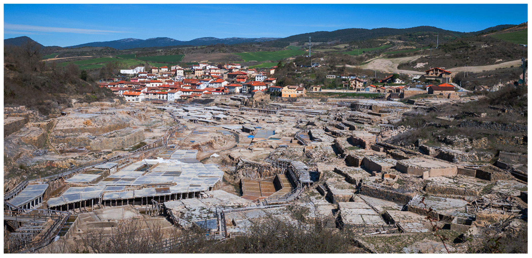
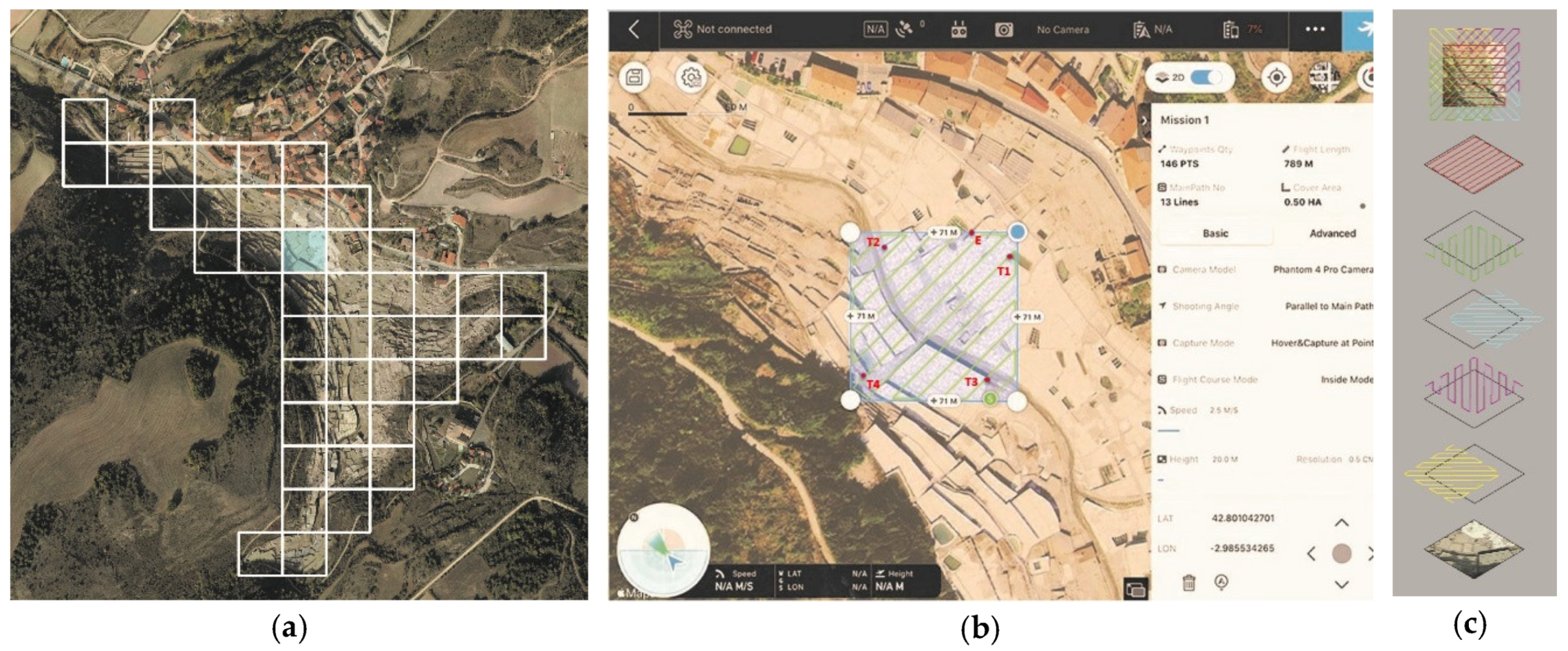
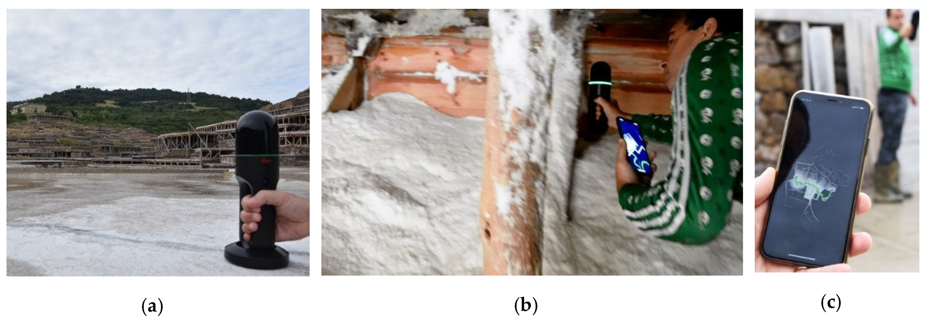
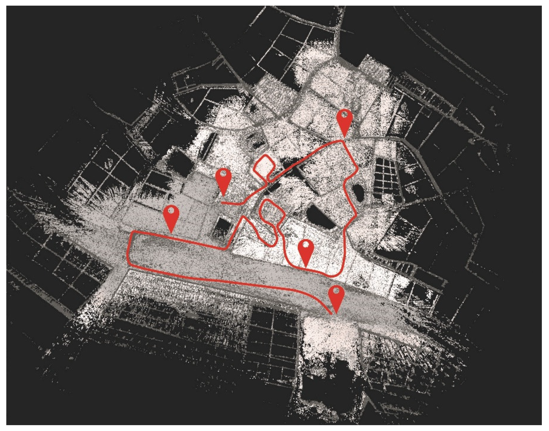
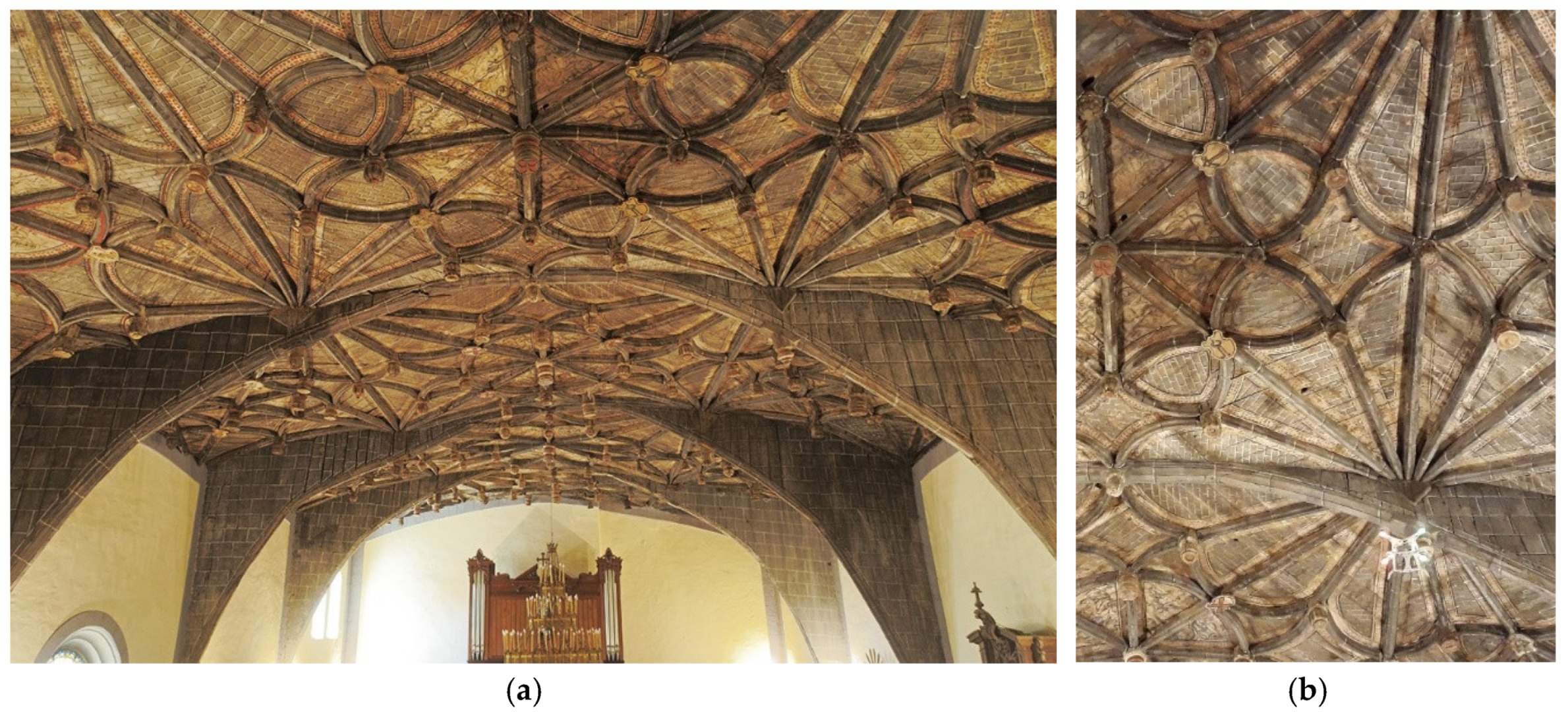
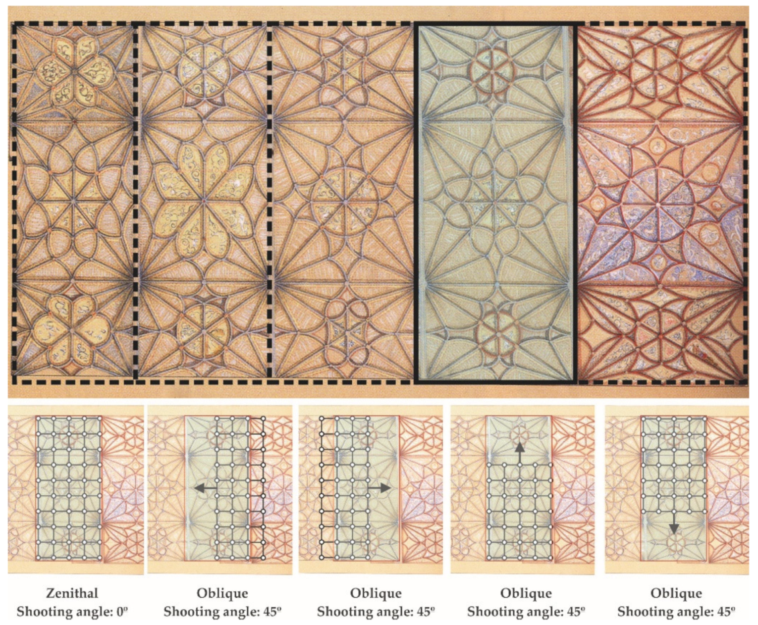
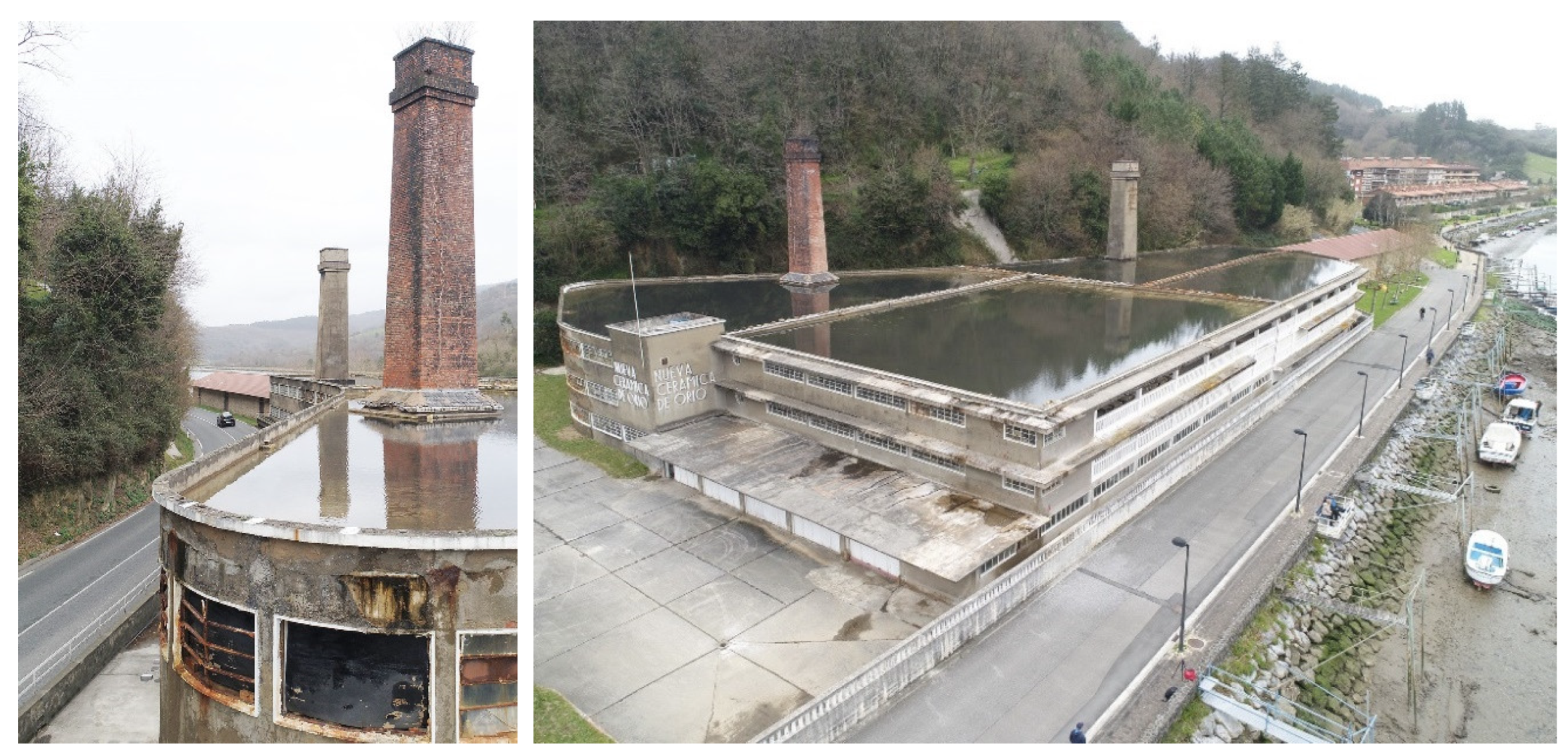
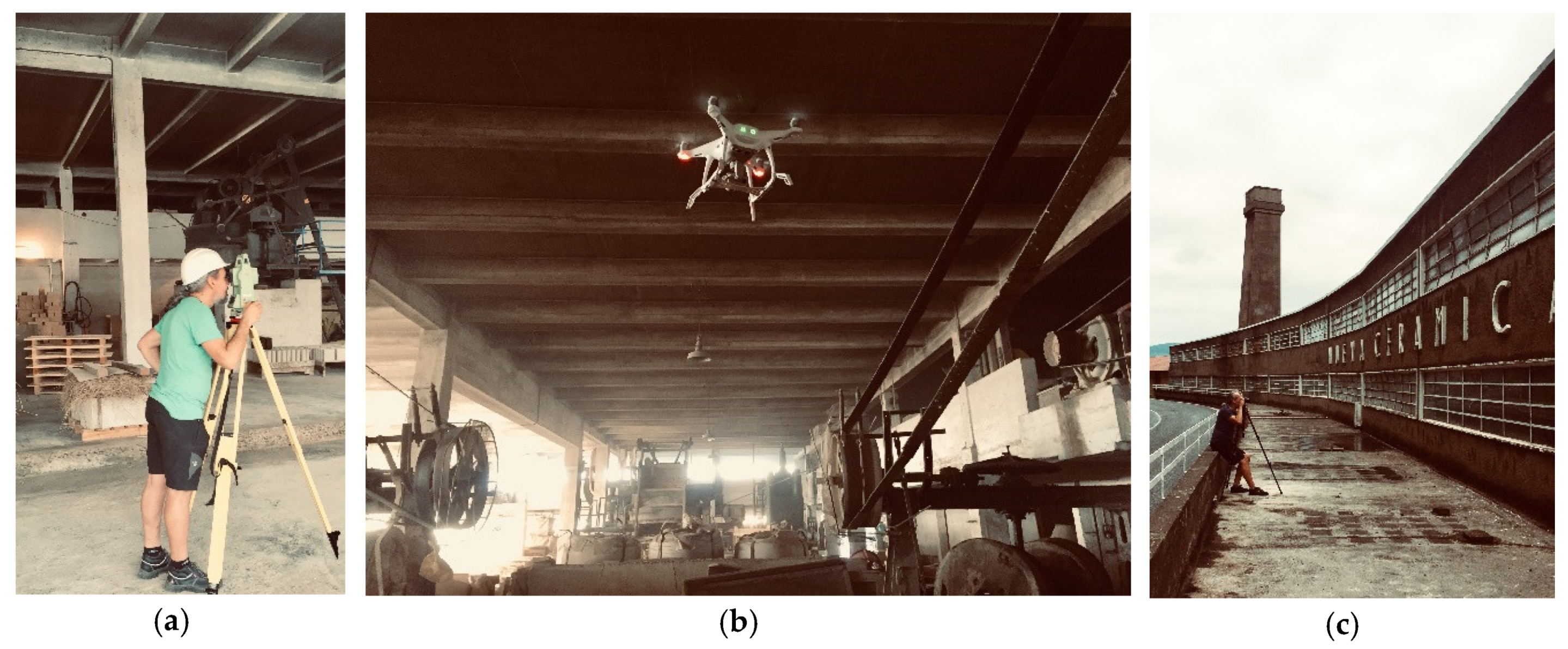
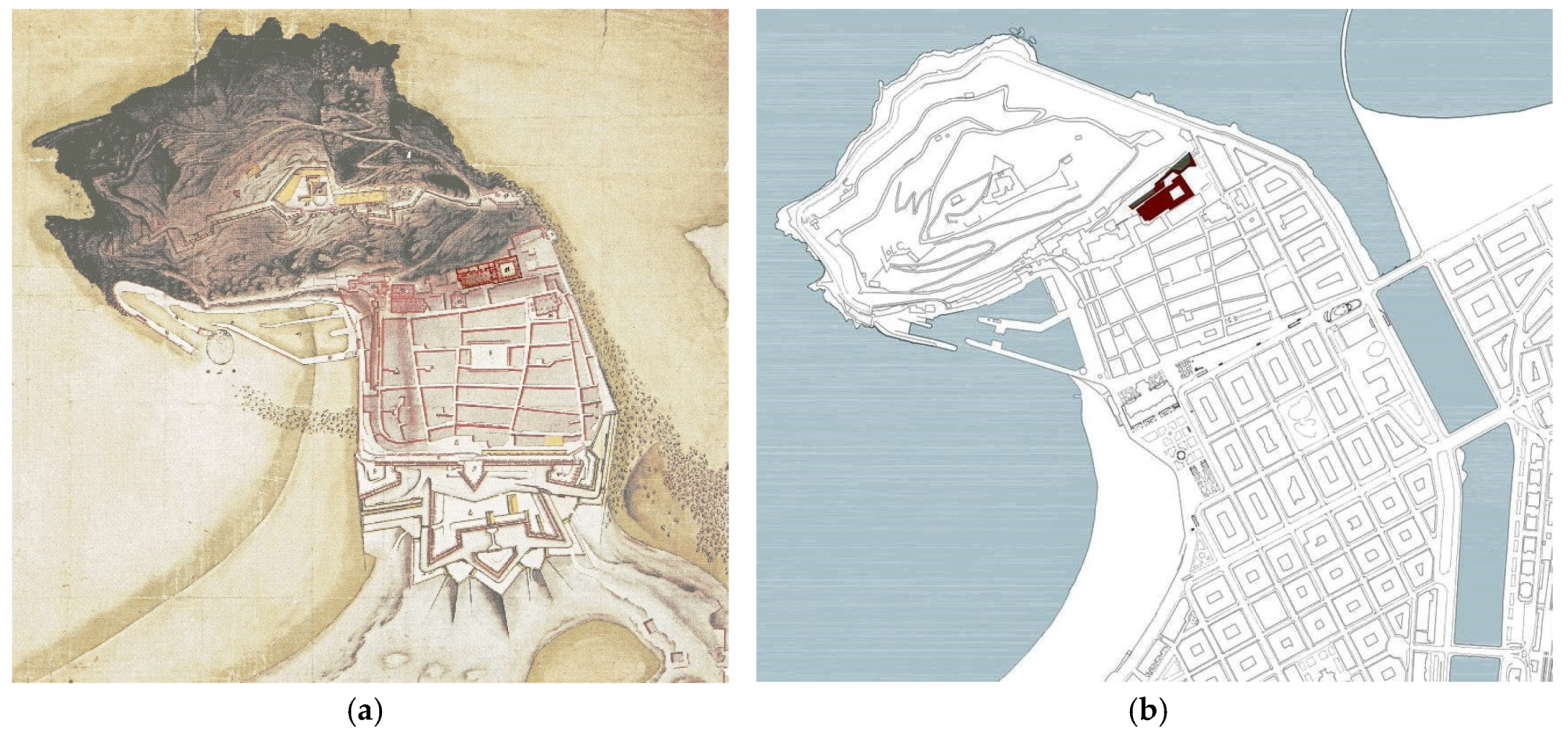
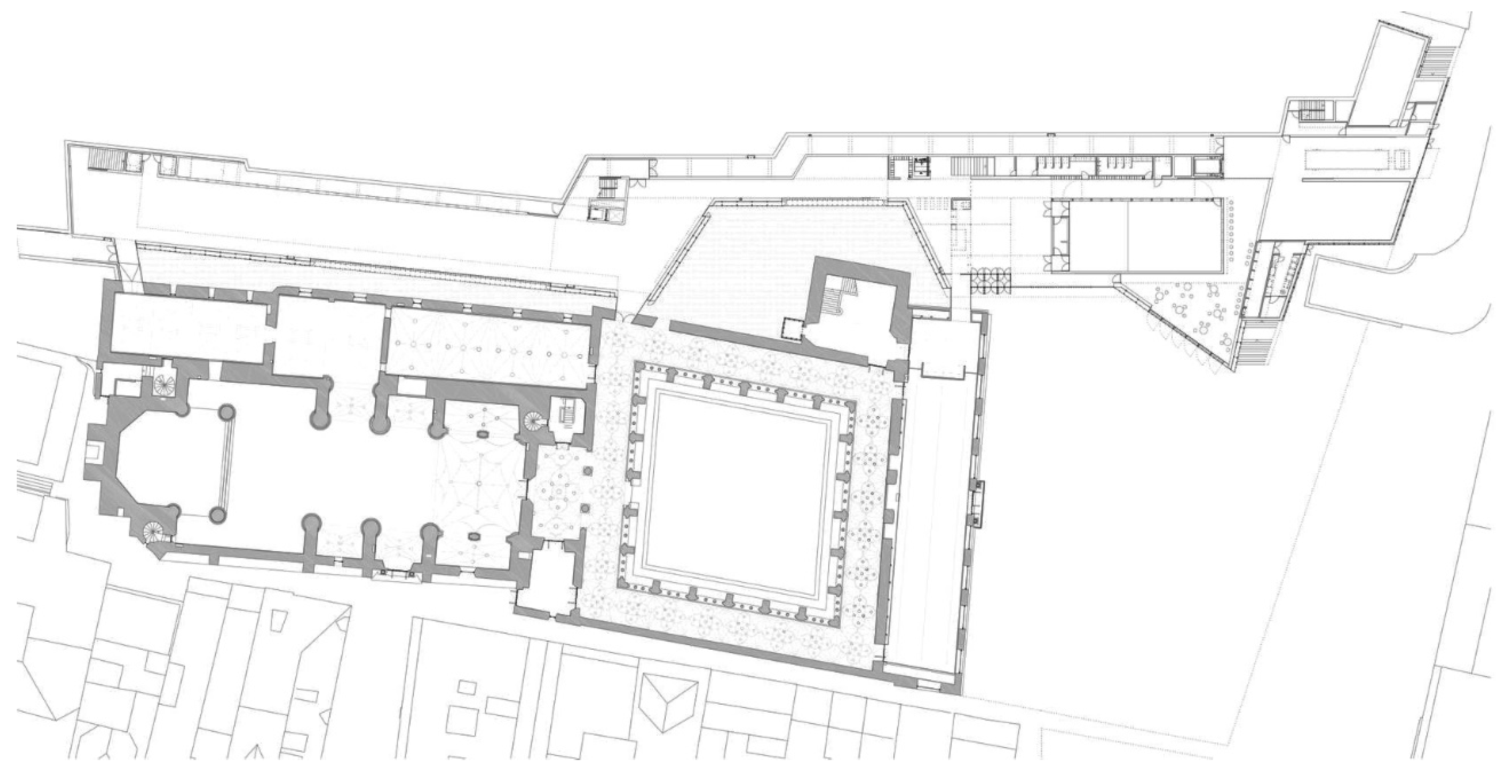
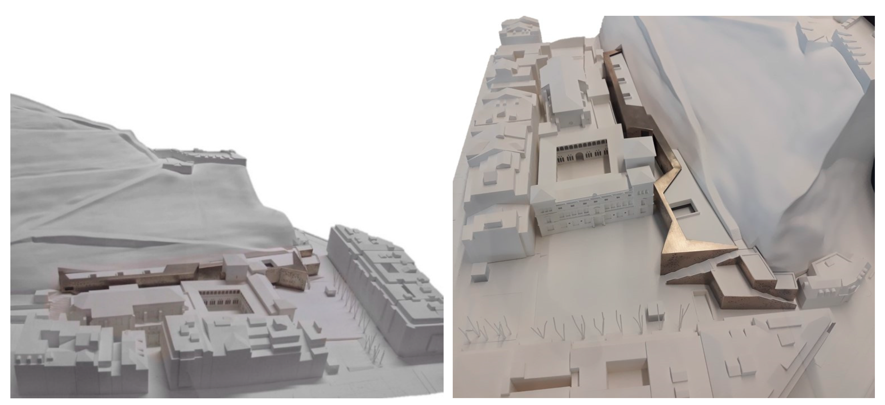
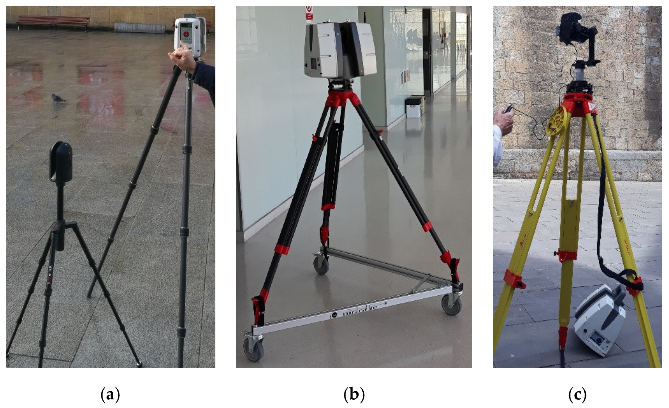
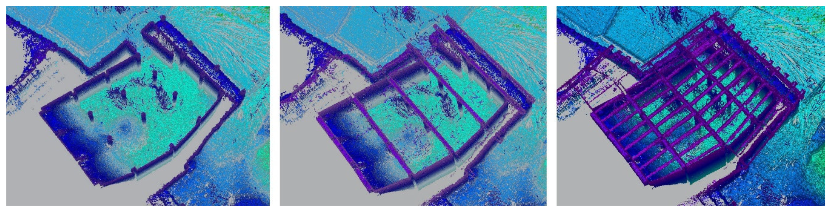
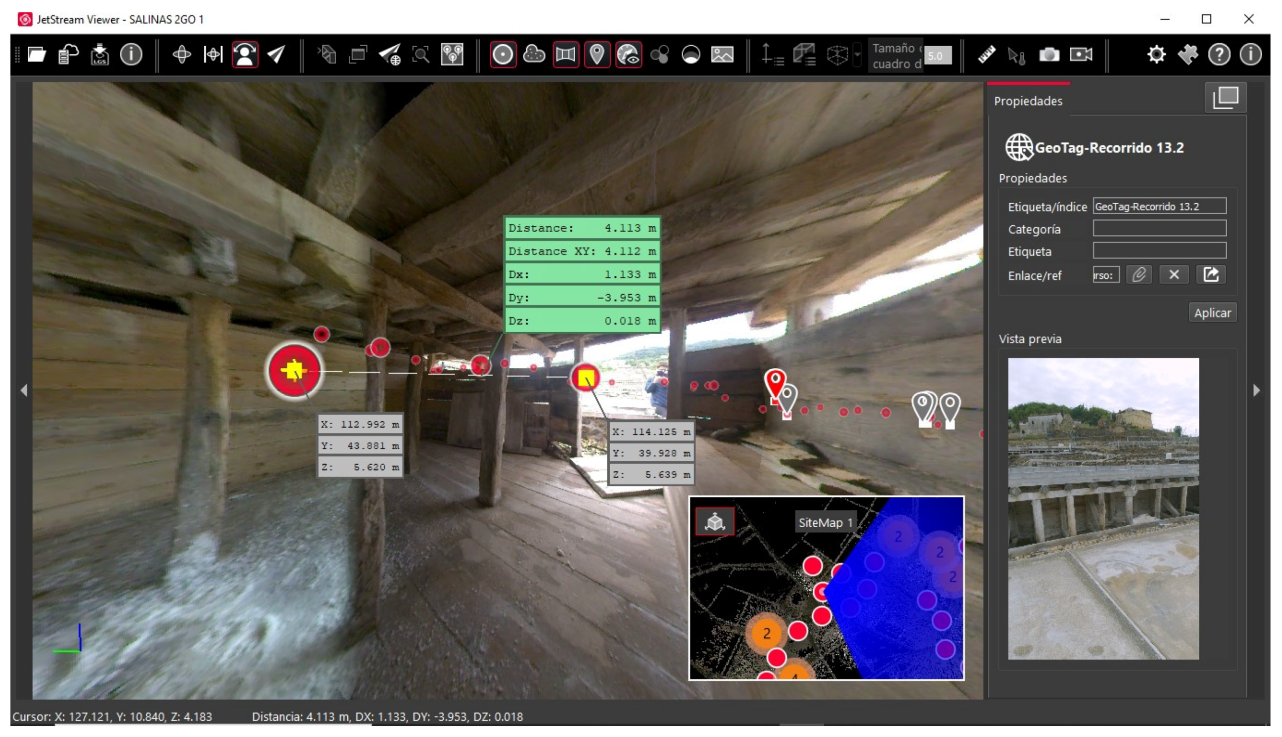
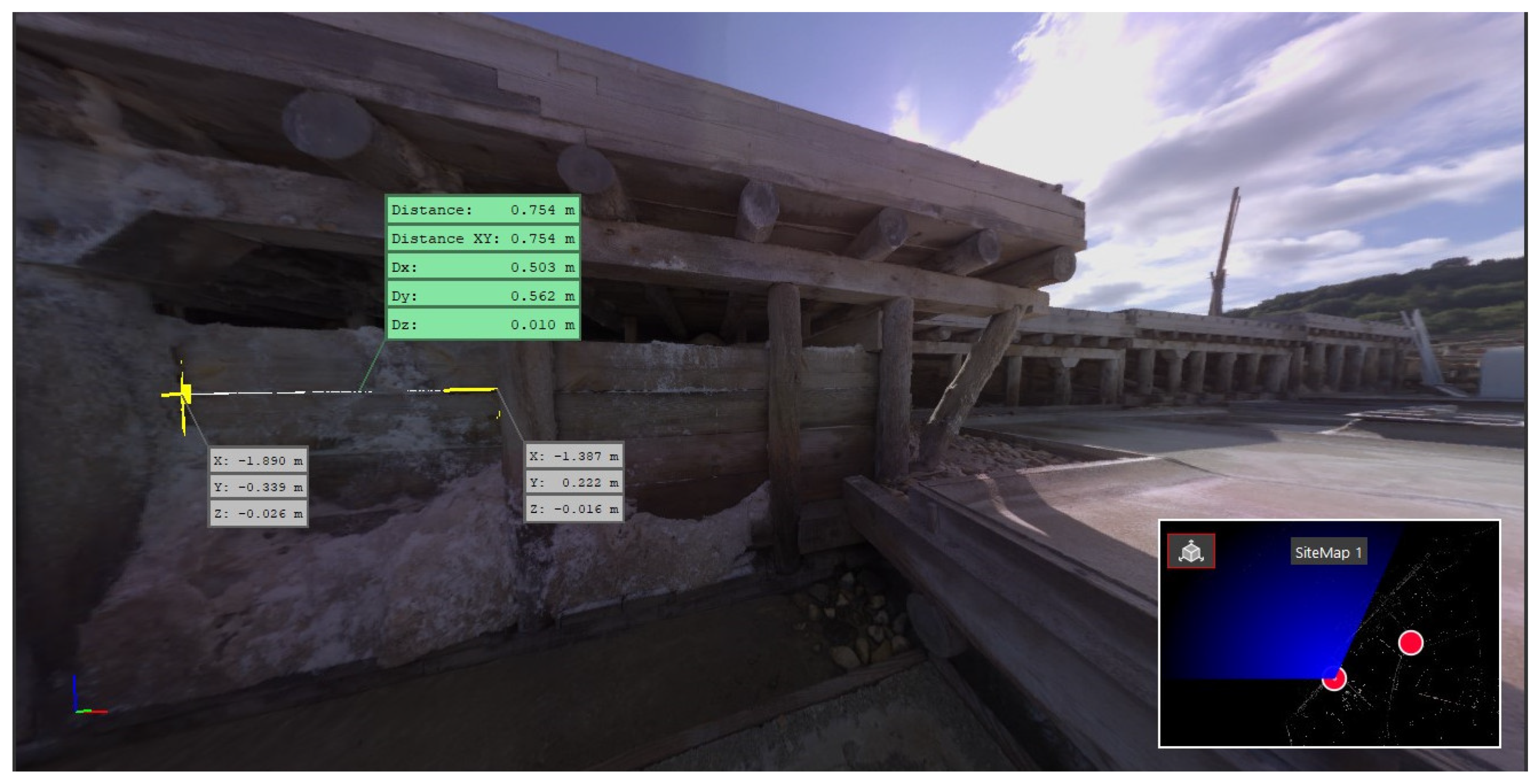
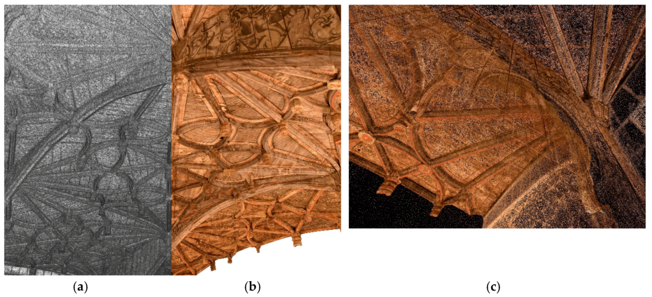
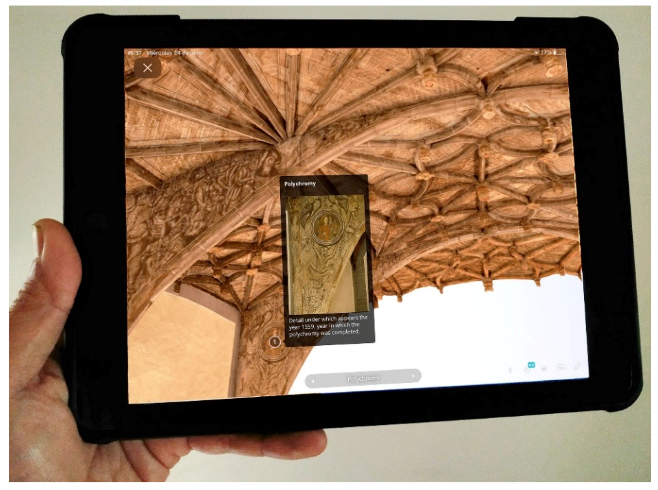
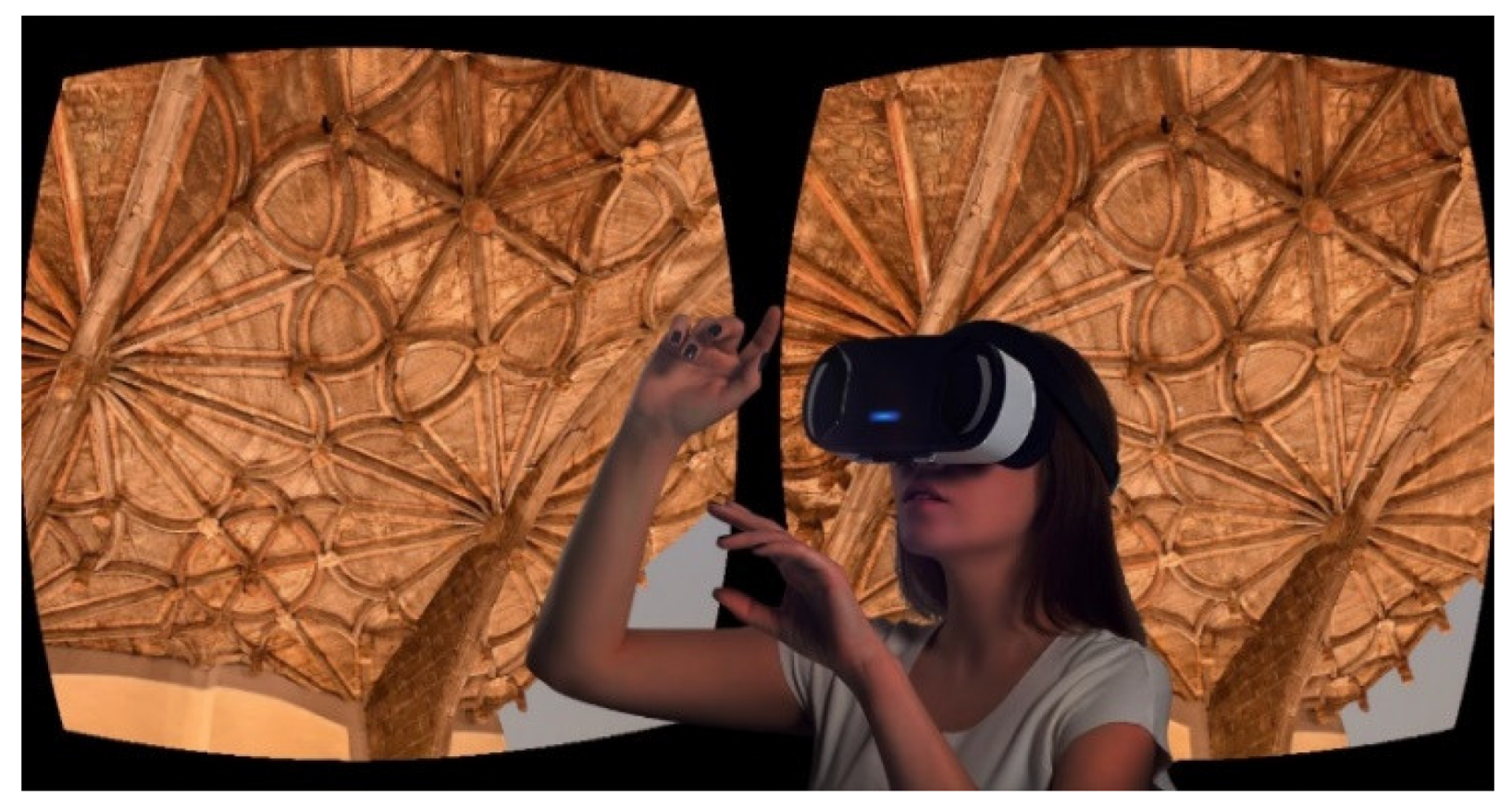
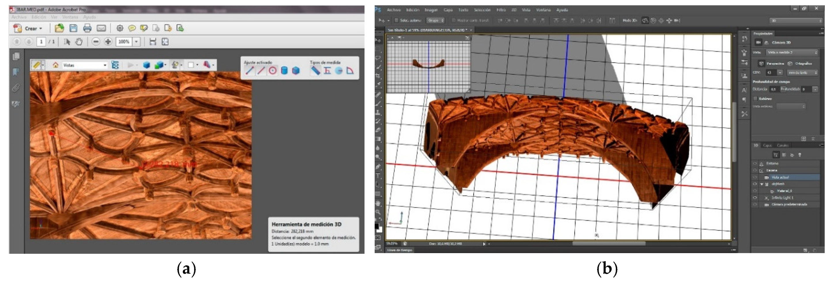
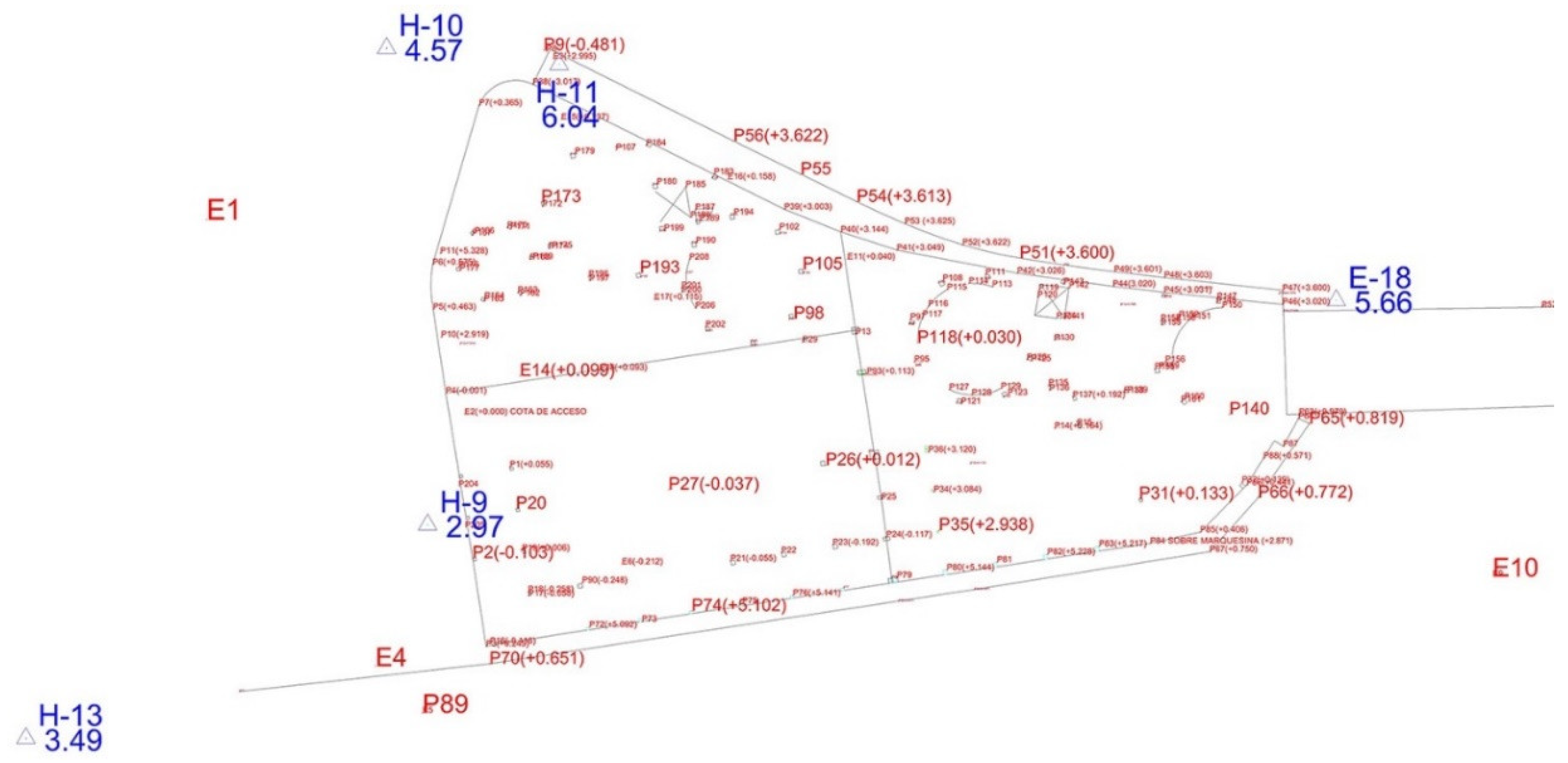
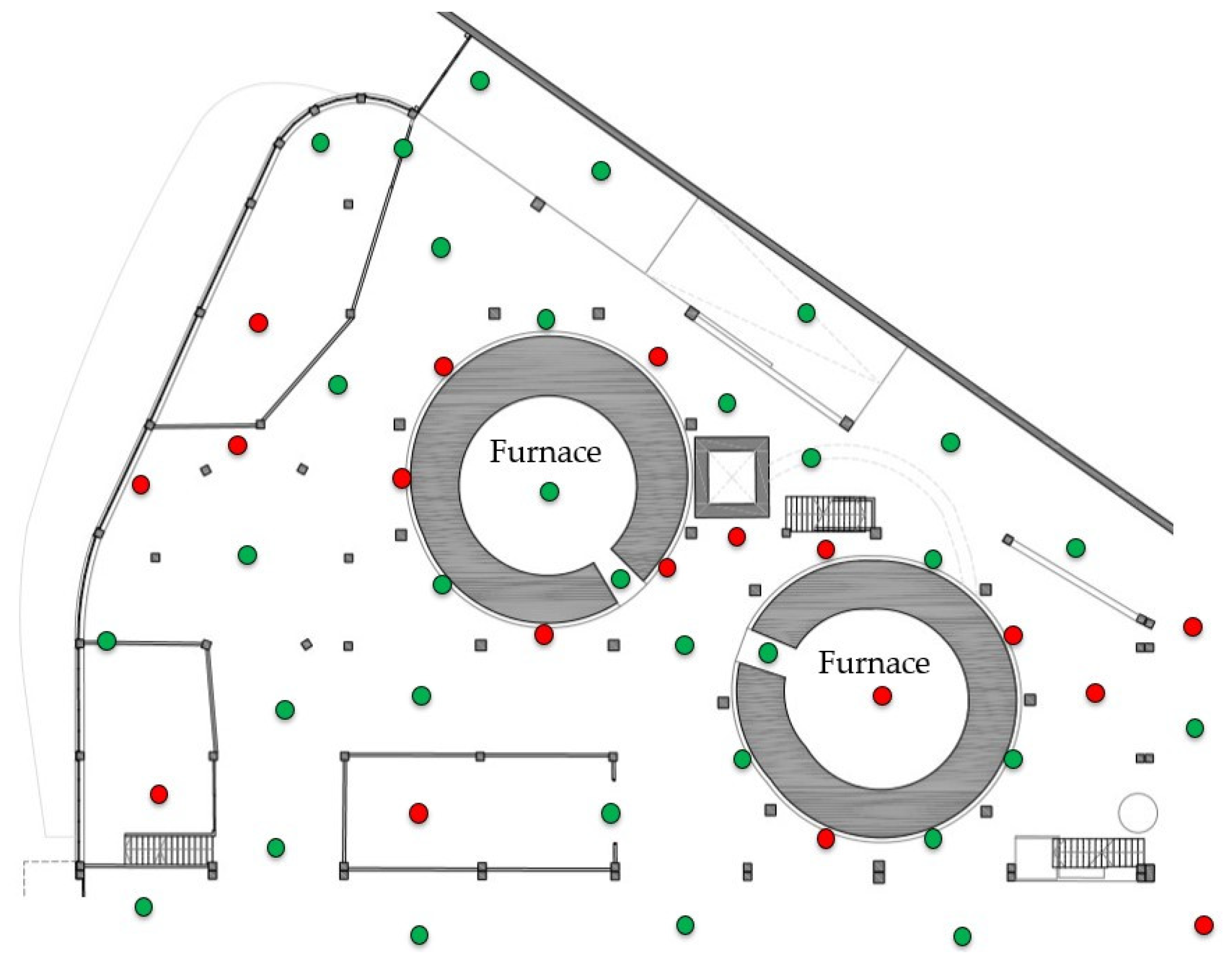
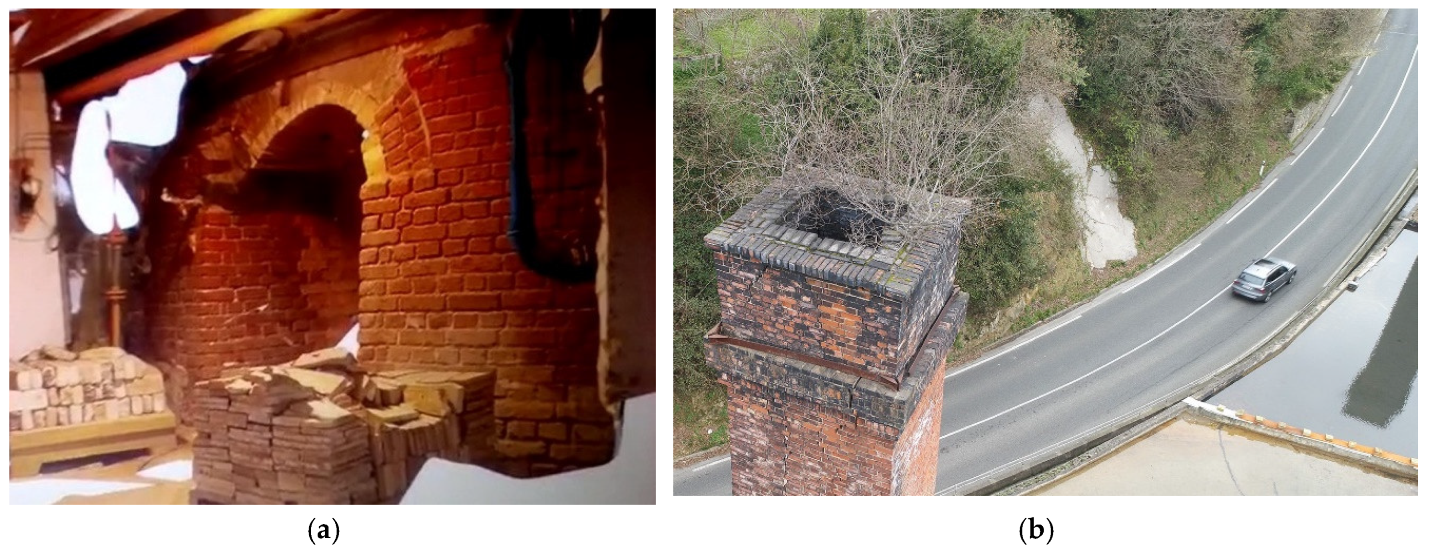
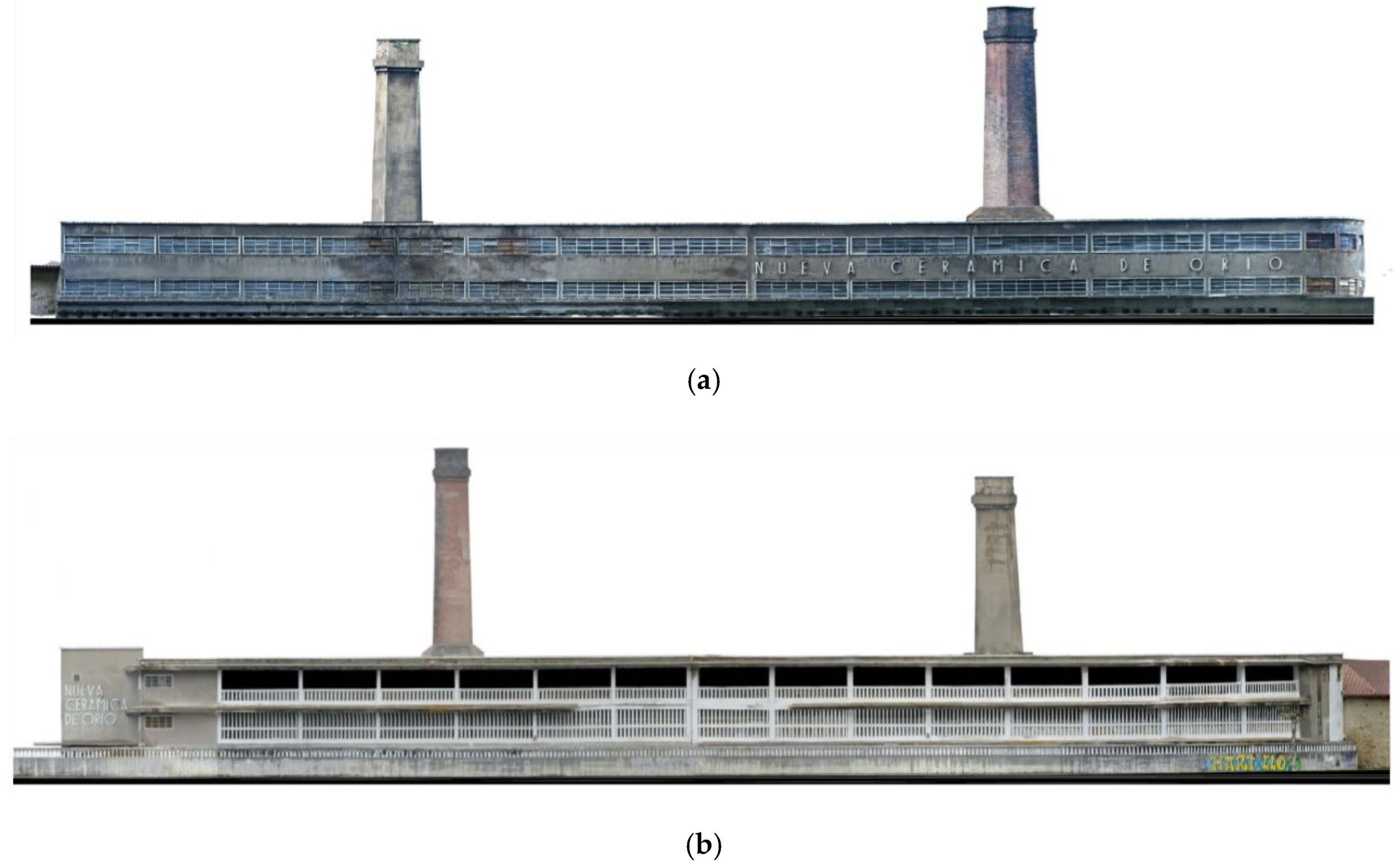
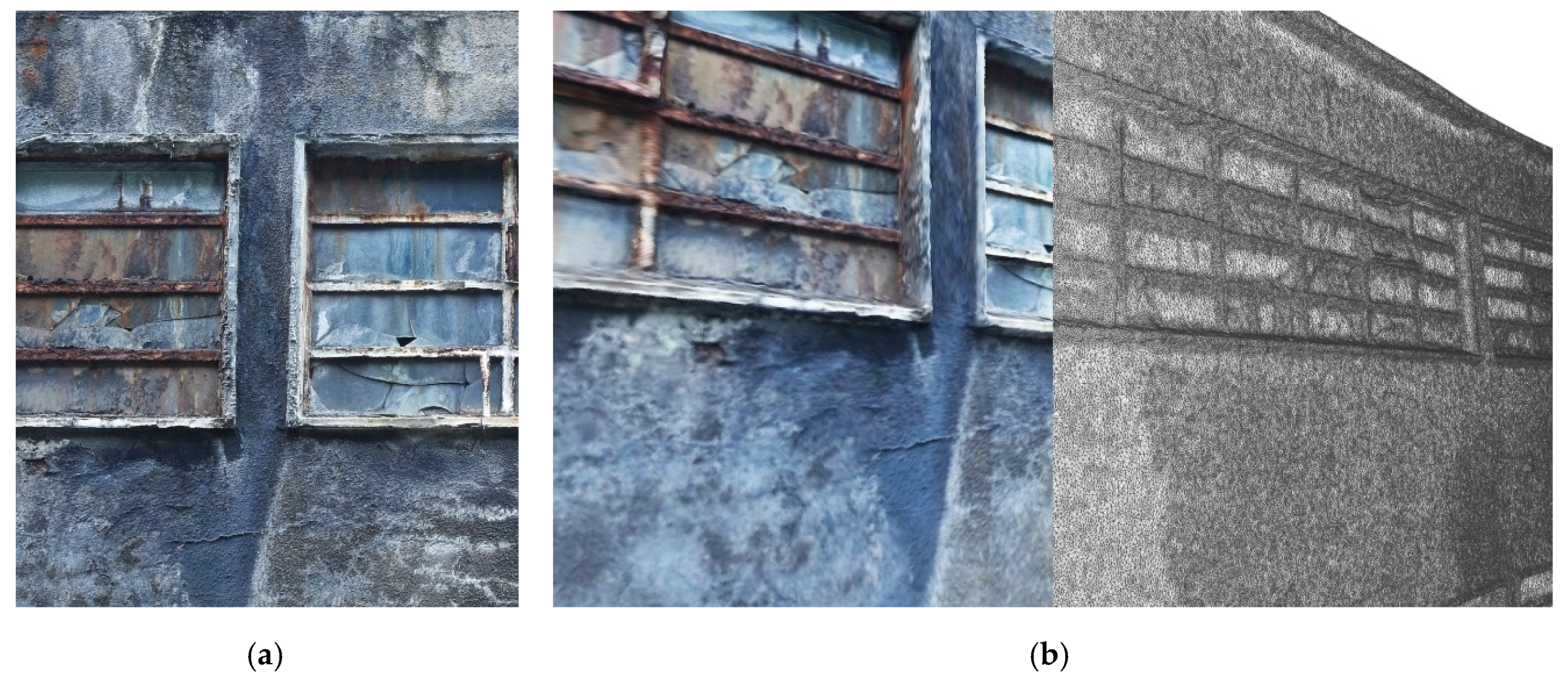
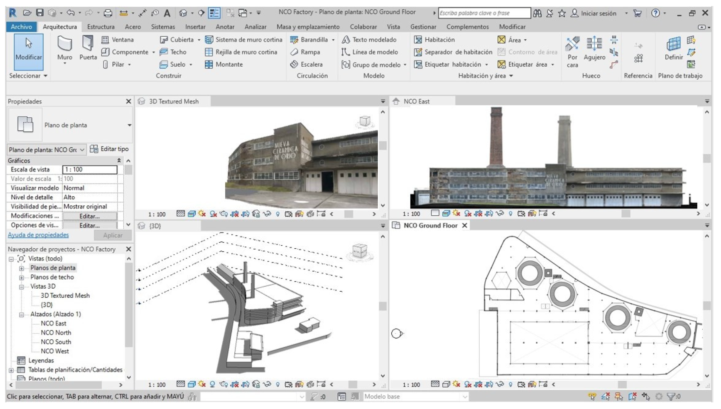
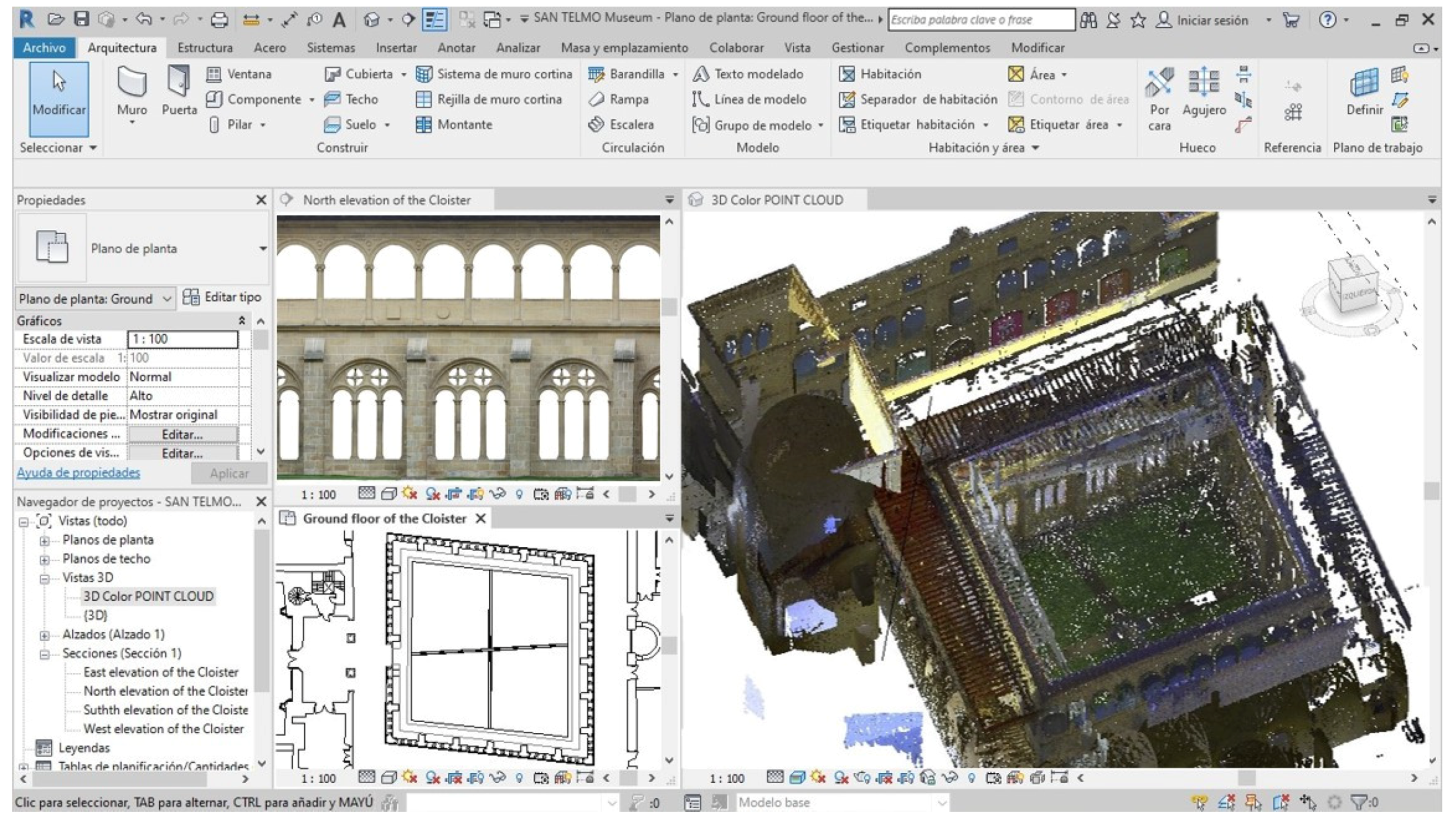
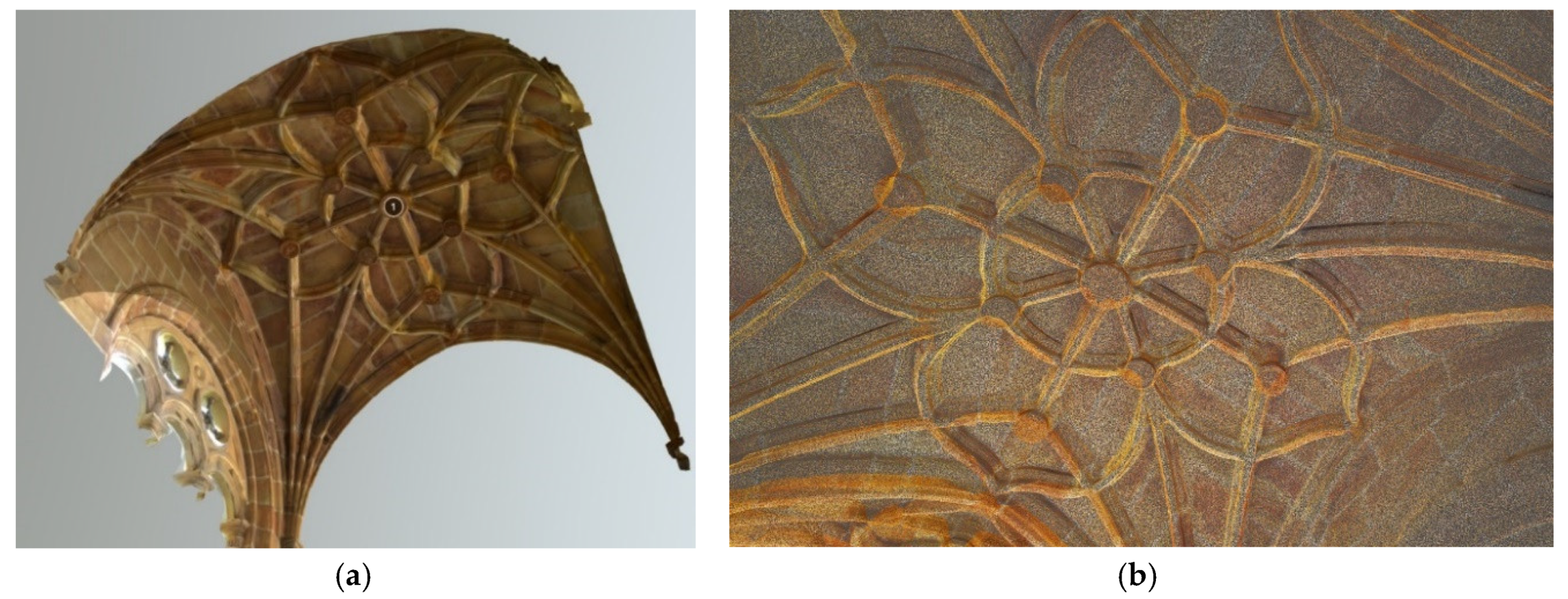
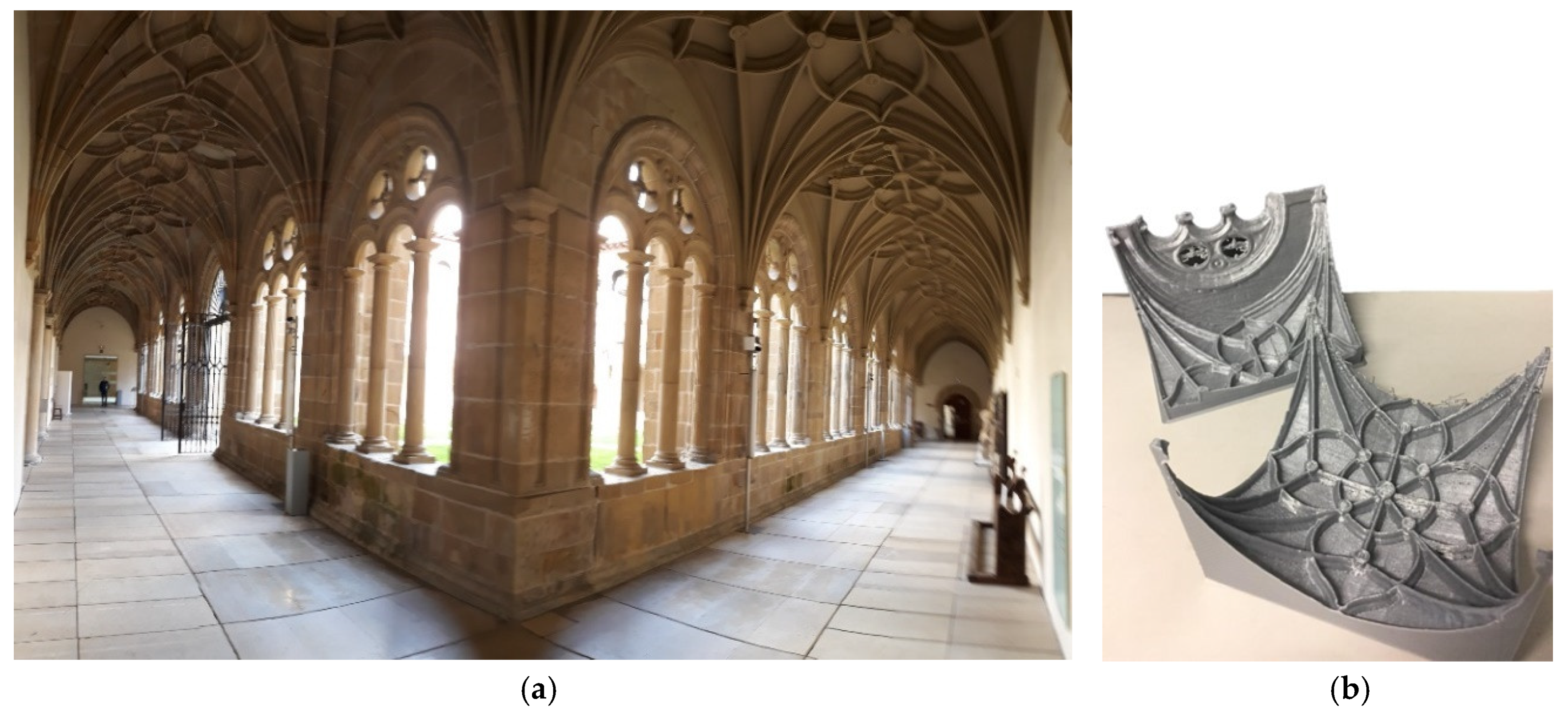
Table 1.
Industrial heritage buildings in the province of Gipuzkoa only.
| DOCOMOMO | AVPIOP * | EKOB * | |
|---|---|---|---|
| Registered | 11 | 20 | 79 |
| Protected | 3 | 7 | 10 |
* Basque Associations for the protection of industrial heritage.
Table 2.
Restrictions in outside data collection.
| Legislation Restrictions | Climatology | Activity in Surrounding Area | Exterior Access | Geometric Complexity | Characteristics of Materials |
|---|---|---|---|---|---|
| Controlled UAV flight in urban area. Need to block road. Permits. | Very rainy, with fog and mist, complexity of data collection. | Residential area. | Uneven but complicated. North façade very difficult. | Very complex due to geometry of the surroundings and the interior structure. | Reinforced concrete, flooded flat roof, steel windows. Large deformations. |
Table 3.
Restrictions in inside data collection.
| Building Activity | Interior Access | Interior Lighting | Geometric Complexity | Characteristics of Materials |
|---|---|---|---|---|
| Actively used. Abundant stored material. | Complex. Large amount of material. Existence of inaccessible spaces. | Uneven. Well-lit areas and others poorly lit. Capture is complicated. | Very complex, because the structure is adapted to the furnaces. | Reinforced concrete. Deterioration of structural elements. |
Table 4.
Summary of UAV photogrammetry capture data.
| Sectors | Flight Height | Ground Sample Distance GSD | Nadir Shot (−90°) | Oblique Shot (−45°) | Frontal Overlap | Lateral Overlap | Flight Time | Batteries | Photos |
|---|---|---|---|---|---|---|---|---|---|
| Sector type 0.5 ha | 20 m | 0.5 cm/pixel | 1 | 4 | 75% | 75% | 55 min | 4 sets | 700 |
| Set of sectors 22 ha | 20 m | 0.5 cm/pixel | 44 | 176 | 75% | 75% | 2420 min | 176 sets | 30,800 |
Table 5.
Summary of BLK2GO dynamic 3D laser scanner capture data.
| Sectors | Itineraries Travelled | Total Length of Itinerary | Link Overlap | Time Spent | Absolute Average Error |
|---|---|---|---|---|---|
| Sector type 0.125 ha | 4 | 120 m | 60% | 8 min | 7 mm |
| Set of sectors 22 ha | 704 (estimate) | 21,120 m (estimate) | 60% | 1408 min (estimate) | 20 mm (estimate) |
© 2020 by the authors. Licensee MDPI, Basel, Switzerland. This article is an open access article distributed under the terms and conditions of the Creative Commons Attribution (CC BY) license (http://creativecommons.org/licenses/by/4.0/).
Share and Cite
MDPI and ACS Style
Leon, I.; Pérez, J.J.; Senderos, M. Advanced Techniques for Fast and Accurate Heritage Digitisation in Multiple Case Studies. Sustainability 2020, 12, 6068. https://0-doi-org.brum.beds.ac.uk/10.3390/su12156068
AMA Style
Leon I, Pérez JJ, Senderos M. Advanced Techniques for Fast and Accurate Heritage Digitisation in Multiple Case Studies. Sustainability. 2020; 12(15):6068. https://0-doi-org.brum.beds.ac.uk/10.3390/su12156068
Chicago/Turabian StyleLeon, Iñigo, José Javier Pérez, and María Senderos. 2020. "Advanced Techniques for Fast and Accurate Heritage Digitisation in Multiple Case Studies" Sustainability 12, no. 15: 6068. https://0-doi-org.brum.beds.ac.uk/10.3390/su12156068
Note that from the first issue of 2016, this journal uses article numbers instead of page numbers. See further details here.