Transforming Unused Spaces in a Shrinking City through Individuals’ Spontaneous Occupation Activities: The Case of Janghang, South Korea

School of Applied Science in Natural Resources and Environment, Landscape Architecture, Hankyong National University, Anseong-si, Gyeonggi-do 17579, Korea
Sustainability 2020, 12(16), 6621; https://0-doi-org.brum.beds.ac.uk/10.3390/su12166621
Submission received: 3 June 2020
/
Revised: 2 August 2020
/
Accepted: 13 August 2020
/
Published: 16 August 2020
(This article belongs to the Special Issue Shrinking Cities—Testing Ground for Sustainability)
Abstract
:This study examines individual occupancy of unused space from an urban management perspective. It also identifies measures for sustainable city management by exploring the changes in unused space and relationships between various stakeholders based on personal occupancy processes. The target area of this study is Janghang, which has been characterized by population decline and economic recession over the past decade. Participants were recruited through snowball sampling and informal interviews, and data were analyzed using the open coding method. The results of the study show that unused space was occupied for various purposes such as to harvest food, pursue leisure activities, and alleviate the adverse effects of spaces remaining unused for extensive periods. The results identified owners, occupants, public organizations, and neighborhoods as stakeholders in unused spaces. Moreover, the neglected unused space was maintained as a managed space through tacit consent as well as flexible negotiation and stakeholders’ collective consciousness. Agreement and coordination among stakeholders and the physical environment of the unused space are crucial factors in managing unused space and landscapes because of the differences between landowners and occupants in a shrinking city.
1. Introduction
1.1. Study Background and Objectives
The demand for urban space is evolving because an increasing number of cities are experiencing continuous population decline and economic recession, resulting in a rapid increase in unused space. Moreover, unused spaces in cities that have remained abandoned for long periods have led to complex problems such as crime [1,2] and reduced aesthetic value [3].
Adjacent areas can be adversely affected by unused space because of changes that may threaten public safety [4]. Therefore, the public sector implements policies for managing and utilizing unused space to ensure fewer spaces of this kind. In particular, these policies promote the revitalization of such areas by improving the environment and reusing the space, and focus on improving neglected public facilities such as abandoned industrial facilities, closed schools, and relocated public institutions. Although several projects and efforts have been introduced in various public sectors for the management and utilization of unused spaces, many questions have been raised regarding their continued use and management because of the ongoing economic downturn and low growth. Studies have highlighted issues with sustainability in the physical conversion of unused spaces [5,6], and addressed the need to involve residents in efforts to continuously maintain them [5,7]. Research also highlights the management of unused and/or neglected private spaces as a key factor in the sustainable management of urban areas [8].
Despite the adverse effects of abundant unused or neglected spaces, small and medium-sized cities in South Korea have maintained cleanliness and peace among residents [9]. Unused spaces in small and medium-sized provincial cities have been spontaneously used for personal occupancy activities. In this study, in contrast to the institutional formality defined by the public sector, “spontaneous activity” refers to the act of informally forming a landscape: Who are the stakeholders involved in the conversion of unused spaces? What are their motivations and purposes for occupying and converting unused spaces? Which factors influence the transformation of unused spaces, and how do stakeholders collaborate and address conflicts during these processes? These informal processes have not been sufficiently studied or considered when evaluating the uses of urban space, even though social healthiness is the primary research topic of sustainable urban management. Therefore, this study focuses on the specific processes (motivating factors, barriers, processes of negotiation, etc.) that can explain their successes or failures. By interpreting individuals’ occupation of unused spaces from an urban management perspective, new space-management possibilities can be identified for cities with declining populations. Moreover, managing private spaces that cannot be easily managed by the public sector can help determine increasingly sustainable measures for urban management.
Because unused space was perceived as an element that can contribute to regional development and urban regeneration, many studies have actively examined how to best utilize it. However, few have evaluated the process of utilizing unused space. The literature has examined the social and psychological effects of community gardens in unused spaces on residents [10]. Furthermore, the social effects of the utilization of unused space, such as reduced crime rates and adverse health effects, have also been highlighted [11,12]. The economic, social, and environmental effects of brownfield utilization have been explored in the literature [13]. Studies have also shown that the utilization of unused space had social, psychological, and environmental effects. However, these studies did not examine in detail stakeholders’ intrinsic social problems generated when utilizing unused space. In particular, because private unused spaces in small and medium-sized provincial cities are being converted according to the complex interactions of interests due to the absence of landowners, the processes used to convert them must be closely examined.
This study explores the process of changes in unused spaces in Janghang, which has long experienced population decline and economic downturn, where individuals have occupied previously unused spaces. The results of the study can be used as baseline data to develop methods to efficiently and sustainably utilize unused spaces in small and medium-sized provincial cities. Moreover, methods to improve the existing systems and institutions are explored in this study.
1.2. Urban Planning Issues and Managing Unused Spaces in Shrinking Cities
Until now, urban planning has focused on the growth of cities [14]. Many urban plans attempt to revitalize cities with the expectation of growth, including population influx and economic growth. However, this growth-oriented approach overlooks the urban and population decline of shrinking cities [15]. Since these plans try to revitalize cities through population influx and job creation, they cannot efficiently handle the issue of the shrinking city [16]. Therefore, plans for shrinking cities must be discussed with a different approach, with a paradigm shift: accept the current situation and improve the life quality of current residents, instead of avoiding current concerns by focusing on growth [16]. Accordingly, this study explored the case of overcoming the dilemma of growth-oriented policies in the context of low growth and population decline by evaluating the increasing amount of unused spaces in shrinking cities as an opportunity and utilizing and managing them through voluntary actions.
Abandoned spaces can be tremendous opportunities because as population, buildings, and jobs decrease, these spaces increase and can be easily utilized in various ways due to comparatively less pressure on development. Diverse policies have been employed to respond to these urban crises after recognizing them as opportunities.
Philadelphia has utilized a “greening” strategy to relieve the decline of the city. It seeks to stabilize the city visually and ecologically through the greening of unused sites. The Philadelphia Green Program, led by the Philadelphia Horticultural Society (PHS), has been implemented to convert vacant sites to green spaces and stabilize the landscape. Additionally, residents have increased their self-initiated competence and received jobs by managing land directly through the PHS Philadelphia LandCare Program [17]. The program provides economic help and opportunities for self-reliance for low-income residents by entrusting them with the management of green areas in connection with real estate companies.
Cleveland also stabilizes the land by planting trees or herbaceous plants on unused sites. It controls the decline of the city psychologically by giving the impression that the city has been managed. Additionally, the Garden Boyz program promotes participation of the local youth as well as job creation. For example, the program rents unused sites and creates gardens to sell harvested crops.
Germany is temporarily using unused spaces by introducing a plan titled “Zwischennutzung” (temporary use). The term refers to a space that is shifting from an empty space to a filled and fixed form for a specific purpose. The plan was introduced to be used for various purposes as a temporary experimental place. Zwischennutzung was chosen as an official urban development strategy in late 1990 as many abandoned spaces were created especially in East German cities after Germany’s reunification [18]. In Berlin, Zwischennutzung has converting unused spaces into new spaces for creative play, such as meeting places, venues, sports events, accommodations, and artificial beaches [19,20].
As a part of Zwischennutzung, Leipzig has implemented a policy to temporarily provide open spaces that are created after demolishing abandoned buildings to the public. It dismantles empty or abandoned houses and converts them into parks or open spaces. It sometimes creates a small forest in the center of a village by planting trees on an open space or expands a garden by demolishing abandoned neighborhood houses. Depending on the size and purpose of sites, it converts them into community gardens, parking lots, small parks, or table tennis courts. Furthermore, through the plan, Leipzig has attempted to create a green belt through small forests, parks, and gardens [21,22].
2. Materials and Methods
2.1. Selection and Status of Study Sites
For this study, the author selected a city that was shrinking because of continuous population decrease and a declining local industry. The population of Janghang, Seocheon-gun, Chungcheongnam-do, was decreasing because of internal (e.g., low birthrate and aging) and external factors (e.g., the damaged fishery industry—the primary industry in the region—and closure of a local smelter). The city’s population steadily decreased from 30,861 people in the 1980s to 11,549 in 2015, a decline of approximately 62.5% (Table 1). Moreover, approximately 76% of buildings in Janghang were old buildings (≥20 years old) in 2016 [23]. Therefore, land prices have plummeted, leading to a decline in industrial and economic aspects (Table 2). As a result, there were many unoccupied and abandoned homes and lots in nearby residential areas. Moreover, sites polluted by past industrial facilities, unused railroad sites, and lighter wharves were abandoned in the city and remained unused. During the preliminary survey, several unused spaces were noted, many of which were used for personal occupancy activities. The distribution of unused spaces was concentrated in residential areas. Therefore, it was decided to focus on this area for the analysis.
2.2. Study Methods
Janghang was selected for the empirical analysis in this study. Various research methods such as field surveys, satellite image analysis, literature reviews, in-depth interviews, and informal interviews were used to address the research questions in this study (Table 3). Specifically, qualitative research methods that could generate abundant interpretations were employed to explore the conversion process of unused spaces.
2.3. Analysis Framework and Data Collection Method
2.3.1. Analysis Framework
This study examined the conversion process, management, and utilization of unused spaces based on the occupancy activities of individuals in a small-sized provincial city that has long experienced population decline and economic downturn. The motivation and purpose of the conversion of unused space, stakeholder dynamics, factors influencing conversion, and appearance and characteristics of conversion were employed as the analysis framework.
The motivation and purpose of the conversion of unused space were expected to differ based on the conversion subject. Specific motivations for individual occupation activities were examined using field surveys based on conversion objectives (i.e., local revitalization, infrastructure expansion, improvement of the living environment, and maximization of usage), which are led by the public sector and were identified in previous studies.
The subjects and characteristics of conflicts were identified through examining the patterns of conflicts and collisions that may occur during the conversion process. Stakeholders include residents and communities, who can be classified into various categories such as occupants, owners, operators, neighbors, and leaders based on their role characteristics. The causes of conflicts between stakeholders were explored in this study, and methods to improve the management and utilization of unused spaces in existing systems and institutions were examined.
In the next step, factors influencing conversion were set as the analysis framework. Moreover, social (human resources, leadership, individual abilities, and relationships between stakeholders), institutional (laws and institutions, awareness of policy executors, and public and private governance), and physical factors (geographic location and characteristics of unused spaces) were evaluated as factors affecting the conversion.
Finally, the appearance and characteristics of converted unused spaces in general were employed to indicate the characteristics of converted unused spaces in Janghang. The motivation for the conversion, conflicts during the process, and influencing factors revealed during the process of unused space conversion were analyzed in relation to physical conversion characteristics.
2.3.2. Data Collection Methods
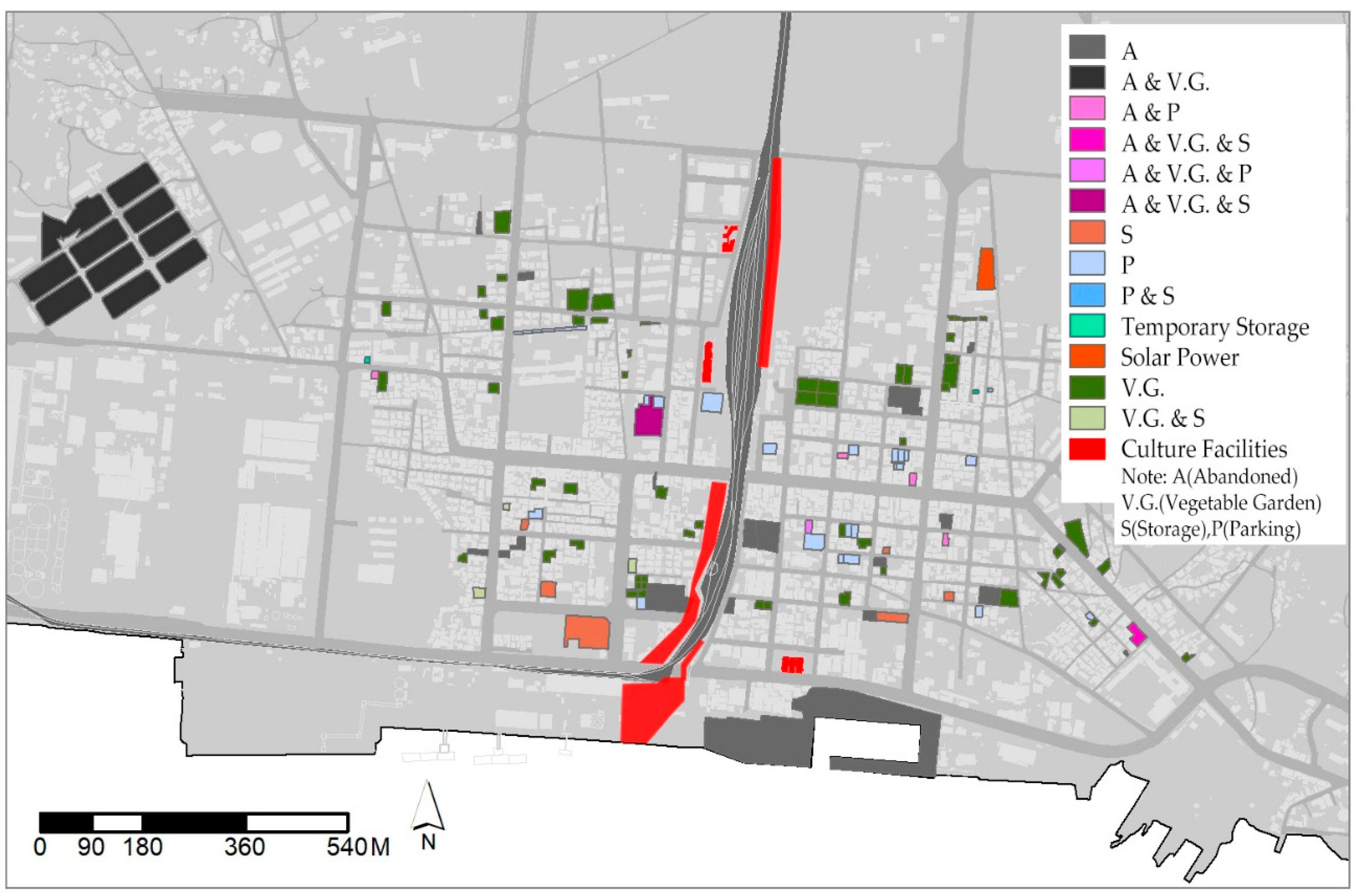
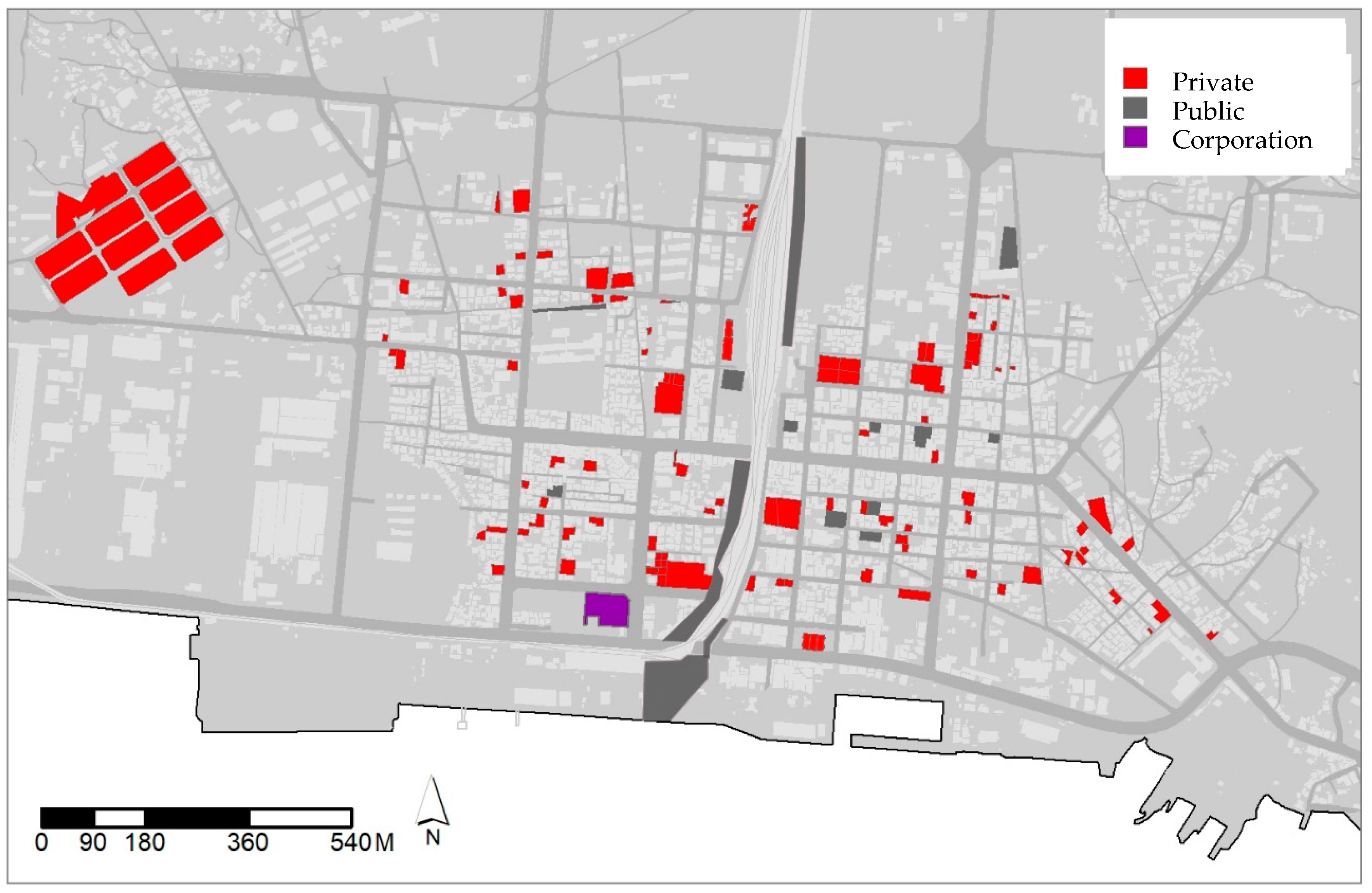
This study attempted to determine how unused spaces were converted through individual activities, problems and conflicts during the conversion process, and characteristics thereof. First, the distribution, utilization purpose, and conversion characteristics of the target unused spaces were identified (Figure 1 and Figure 2).
The study identified unused spaces using satellite images and field surveys. Adobe Illustrator™ was used to mark spaces estimated to be vacant lots according to the most recent satellite images obtained in 2016 by the National Geographic Information Institute. A field survey confirmed the status of the vacant lots. After the survey, previous uses of these areas were identified to determine if the candidate sites were unused spaces. Previous uses were determined through a satellite image analysis and data from the literature. Satellite images captured in 1985 by the National Geographic Information Institute were used because they had a high resolution and Janghang was flourishing in the 1980s. The distribution map of vacant lots was prepared using the obtained 1985 satellite images and results of the field survey. Maps were overlaid using Adobe Photoshop™ and examined to determine whether the identified vacant lots were previously developed. Furthermore, to reduce the possibility of errors, the previous building locations were checked using documentation. The locations were identified by collecting the demolition management and obliterated building ledgers, and listed areas targeted for vacant housing management projects through the Regional Development Team and Landscape Housing Team of Seocheon-gun. To identify who used these unused spaces, their owners were identified using real estate integrated certificates obtained from the efficient and convenient real estate complaint site.
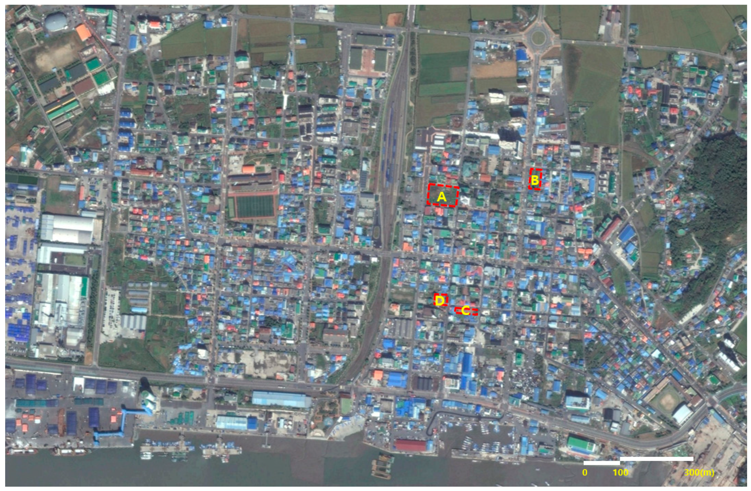
Although the best method was to directly visit and check the status of the subject using a space, the field status was checked after document-based screening because the investigators had limited opportunities to meet those who used a significant number of unused spaces. When an owner’s address, which was obtained from the real estate integrated certificate, was verified as identical to the address of an unused space, it was determined that the owner was using the space. When there were difficulties concluding whether the owner was using the space because the owner’s address was nearby, the address was confirmed by inquiring with neighbors during the field surveys. Based on the results of this screening, a preliminary in-person interview was conducted with occupants to determine the reason for and process of the occupation of 28 vacant lots. An interview notice approved by the Seoul National University Institutional Review Board (IRB) was posted regarding the target areas, and the study author awaited contact from potential participants. However, there were difficulties in recruiting participants. Therefore, after waiting near the unused spaces, residents who came to use the space were recruited in person. When it was difficult to meet anyone despite waiting for long periods, the surrounding houses were visited and details sought in person about who was using the unused space. Relevant information was obtained, and participants were recruited using snowball sampling. For this study, the author selected unused spaces for which conflicts of interest or cooperation arose in the process of occupation or spatial transformation conducted by occupants (Figure 3).
The researcher formed a fellowship by contacting occupants, who we met through the preliminary and subsequent field surveys. After the sites were selected, data were collected through in-depth interviews. Data were collected through nine visits over 19 days from the beginning of the field survey in February 2016 to February 2018. In-depth interviews were conducted with stakeholders (Table 4). When multiple users occupied one space, data collection was stopped after theoretical saturation was reached and no new facts emerged. In addition, when a source of disagreement was noted in the collected data, government officials and landowners were interviewed to clarify the situation. It was difficult to obtain landowners’ contact information because of the Personal Information Protection Act in Korea. However, it was possible to visit the landowners after obtaining an address from those living in the neighborhood, meeting the owner after the head of the village contacted him or her on our behalf, or through a phone interview. Interviews were conducted in gardens, village shelters, or participants’ homes to ensure a comfortable environment. Data were collected using memos and voice recordings with participants’ consent. The interviews employed an open semi-structured form so that the participant could freely express subjective thoughts and emotions without the researcher deviating from the focus of the study. Therefore, the interview was based on the list of major questions (Table 5) prepared in advance, which ensured flexibility according to interviewees’ responses. For example, the reason for the occupation was asked as one of the main questions. When an interviewee answered that he or she occupied it for a management purpose, the interviewer flexibly created questions such as whether the government had managed it until then or if the owner had managed it. Considering that the participants were mostly senior citizens, we used straightforward and easy words.
3. Results
Participants reported that they occupied and converted the unused spaces to reduce the adverse effects of extensive periods of continued disuse, and for harvesting food, exercising, enjoying hobbies, and using the space in general. Participants also reported that they occupied and converted the unused spaces based on their personal motivations. In particular, because the unused space was left unattended, it adversely affected the cleanliness and surroundings of the neighborhood and threatened residents’ safety because of the potential for criminal use. Therefore, neighborhood residents voluntarily occupied and managed the unused spaces to alleviate any adverse effects. These converted unused spaces had different owners and occupants, and spatial characteristics that could be temporarily changed. The conversion primarily occurred in residential areas for the purposes of farming, parking, and storage. Stakeholders in the conversion of the unused spaces took the form of unauthorized owner–owner–public, tenant–owner–neighborhood, and owner–unauthorized owner–neighborhood relationships. It was found that laws, institutions, policies, personal needs, relationships, and agreements between stakeholders as well as location conditions affected the conversion of unused spaces. Occupying the unused space led to the management and mitigation of the adverse effects of these spaces. There were three methods of converting a space through occupation.
3.1. Unauthorized Occupation and Implicit Consent of Stakeholders
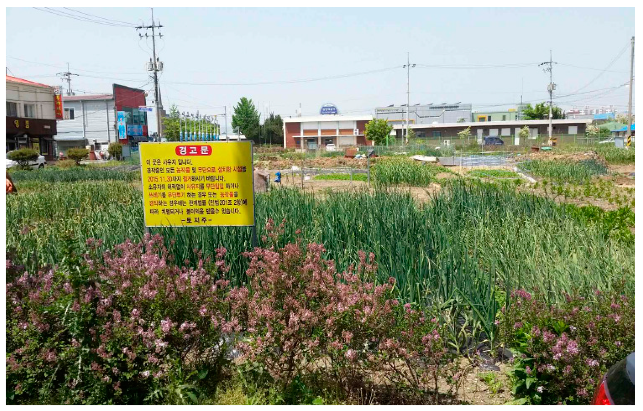
Unused spaces were converted by being occupied with the connivance and implicit consent of landowners and public agencies. The unused space “Site A” (Figure 4) was occupied by the neighborhood without permission and converted into a vegetable garden over the past 20 years.
Owners and occupants acted based on their own interests. Occupants began using the unused space when it led to the deterioration of the surrounding environment. Moreover, they created a vegetable garden to sustain their livelihood. Because the unused spaces were converted for farming, owners benefited through reduced property tax. Therefore, while they strategically sanctioned land occupation, they connived as well. Furthermore, while the public sector was aware of the adverse effects of the unused spaces and conflict between owners and occupants, it implicitly allowed their occupation. The owners learned about the legislation allowing illegal occupants to claim the lands after occupying them for 20 years. Therefore, they implicitly allowed them to occupy the lands for the property tax benefit, but intermittently hindered occupants’ cultivation activities and caused conflicts that would create evidence showing they did not tolerate use of the land.
Site A was located directly across the old Janghang station. This site was approximately 1100 pyeong in size and divided into four lots, but was owned by one person. It was occupied by warehouses and houses during the Japanese colonial era. However, they were bombed during the Korean War, and only two or three warehouses remained intact. One house was abandoned after a fire. The landowner rented out the warehouses in 1967 when he moved to Seoul. Since the 1980s, the central part (of the land) was rented for use as a roller-skating rink, which was popular during that time. Since the economic depression of the late 1990s, the place is no longer rented. The sites of structures such as warehouses remained unused after the buildings were abandoned and demolished. Similarly, the target area remained unused with some remaining debris and a bad odor because villagers dumped waste there. The waste transformed into manure, resulting in the growth of thick grass and increased rat and insect infestations. When snakes were found, the neighborhood decided that the land should not remain unattended. Villagers removed the thick grass and created a vegetable garden. Over the previous two decades of occupation, there were conflicts with the owner, who pressured them to stop farming. However, they continued to occupy the space based on their desire to improve the environment and need for food. Most users were aged more than 70 years, and their source of livelihood was unstable. The vegetable garden was an expression of a right or desire for residential stability, not a hobby. Users A and B, who maintained the vegetable garden from the beginning, considered themselves socially vulnerable or second-class citizens, and obtaining food through cultivation provided significant help in “supporting their lives”. Some users stopped cultivation activities because of pressure from the owner; however, they were replaced by new users who wanted to use the land for farming.
“We are powerless and poor people living in a rural area. We do not grow vegetables as a hobby or for fun. We have nothing to say if the owner asks us to stop using the land. However, it will be difficult for us to sustain our livelihood without it. Rich people may think it is not a big deal and it only earns us pennies. However, it helps us a lot.”—User B (male, older than 70 years)
Although the ownership had been maintained over the previous two decades, the management of the land was passed to the next generation because of the advanced age of the owner. This led to conflicts associated with land occupation. The owner’s son requested the villagers to stop using it as a vegetable garden and uprooted the vegetables before returning to Seoul. The villagers stopped farming activities. However, the land used for the vegetable garden was fertile, and weeds grew faster than before. Consequently, the residents reoccupied the unused space as a vegetable garden. Some people who initially used the unused space had stopped farming and were replaced by other residents. Because they continued to cultivate the land, the owner’s son responded strongly by posting a warning sign, damaging all crops, and sending out a memorandum indicating that users should not exercise possession. Although the residents did not know about this, the owner enacted stronger measures than previously used to deter users because the management body had changed. Furthermore, the owner knew about Article 245 of the Civil Act, “Period for Acquiring Ownership of Immovables by Possession”. According to this article, “A person who has for 20 years peaceably and openly held possession of an immovable with an intention to own it, shall acquire ownership by making registration thereof.” The owner took stronger measures than his previous attempts to oust users, because he was concerned they might legally claim the land, given that nearly 20 years had passed since they had first occupied the land without permission. The owner’s son attempted to lease the land to people who wanted to use it as a vegetable garden, because he was worried about residents’ continuous occupation of the land. However, no resident wanted to rent the lot. Because the land had been used as farmland, separate taxation had been imposed, lowering the property tax. Therefore, the owner was willing to tolerate the occupancy if he could not rent out the land.
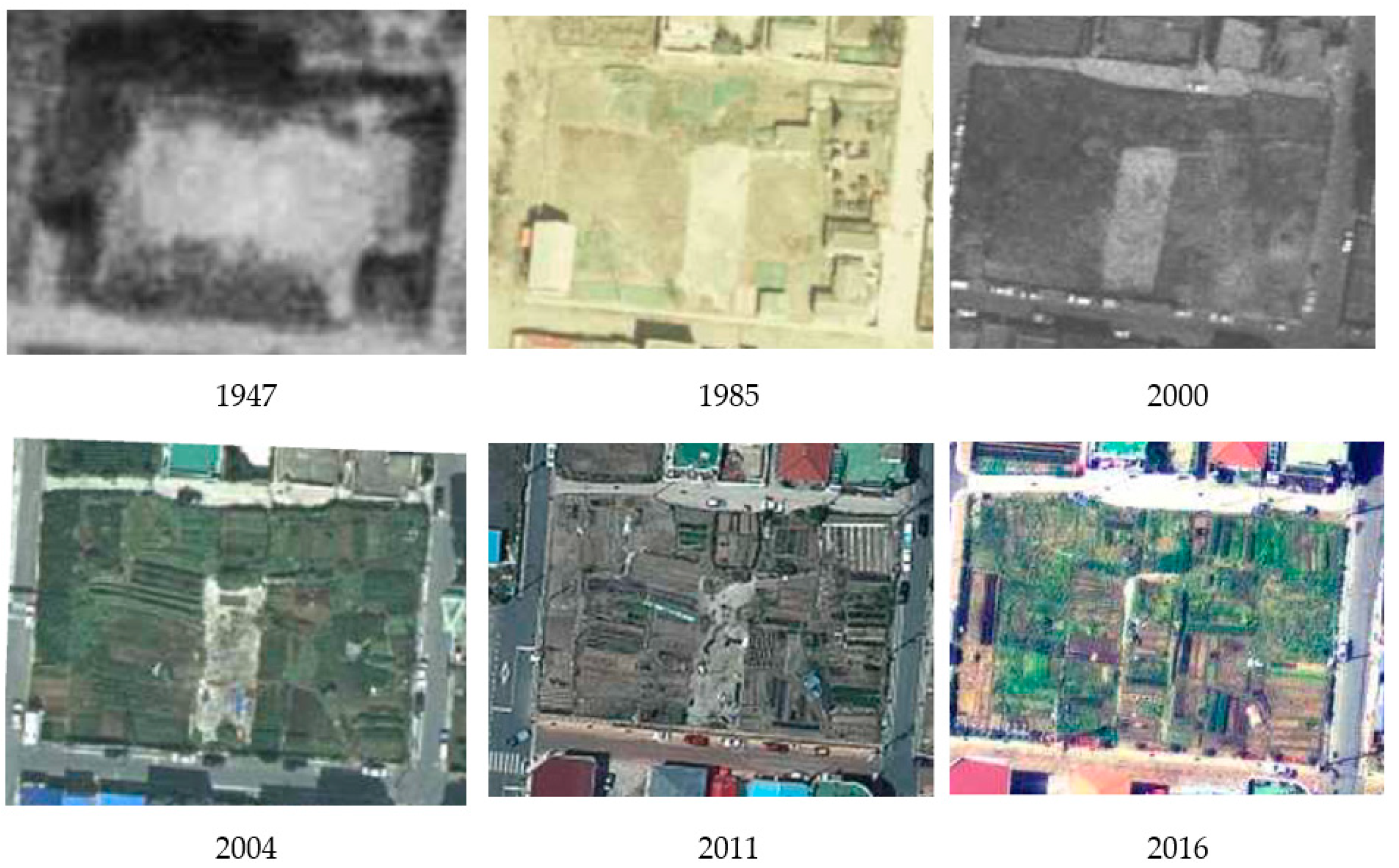
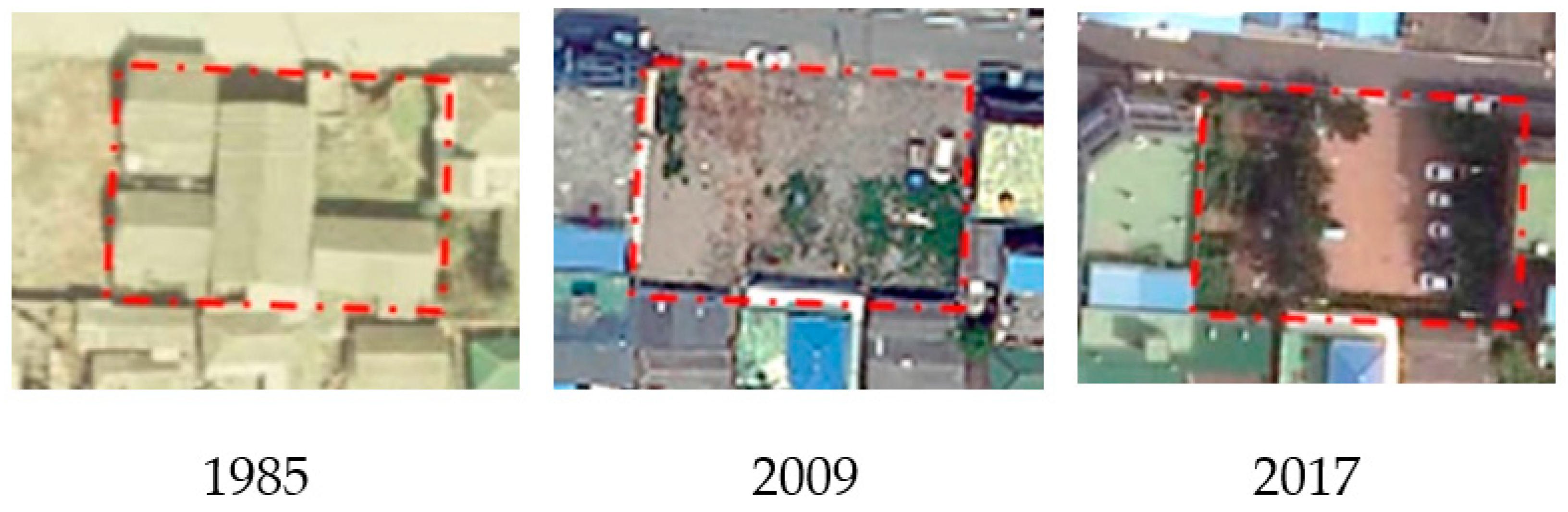
Seocheon-gun officials attempted to purchase the land during the Janghang revitalization promotion project in 2008 because of its geographic importance and continuous complaints about bugs and odors. However, the purchase failed after disagreements regarding the purchase price. Moreover, the roller-skating rink located in the center of the site had been paved with concrete; therefore, it could not be converted into a vegetable garden (refer to Figure 5, 2004). Instead, residents used it to store their farming tools and spread their harvest, and sometimes sat there and ate together. Although the place was used more often and simultaneously by many people, the central space not occupied by a specific person began to get dirty. Residents filed complaints and worked with the town office to cover the concrete pavement with soil. Other residents then occupied the newly made land. The “implicit consent” about land occupation, such as the attempt to purchase the land and residents’ collaborative efforts to cover the land with soil to improve fertility, led to changes in the continuously occupied unused space and its more diverse use thereof. The public sector’s intervention offset the exclusion of private space and increased the number of occupants, as more land became available after the roller-skating rink was covered with soil.
This case shows that individuals’ unauthorized occupation transformed the unused space beyond the borders of illegality based on the implicit consent of the owner and public authorities. Residents of the neighborhood near the unused space thought that occupying the land without permission was a natural response to the deterioration of the surrounding environment, which adversely affected them. Thus, they did not feel guilty about it. Stakeholders acted according to their own interests, and the unused space was converted and used according to an unofficial occupancy phenomenon that cannot be explained within a legal and/or illegal framework.
3.2. Maintaining Unused Space through Sharing
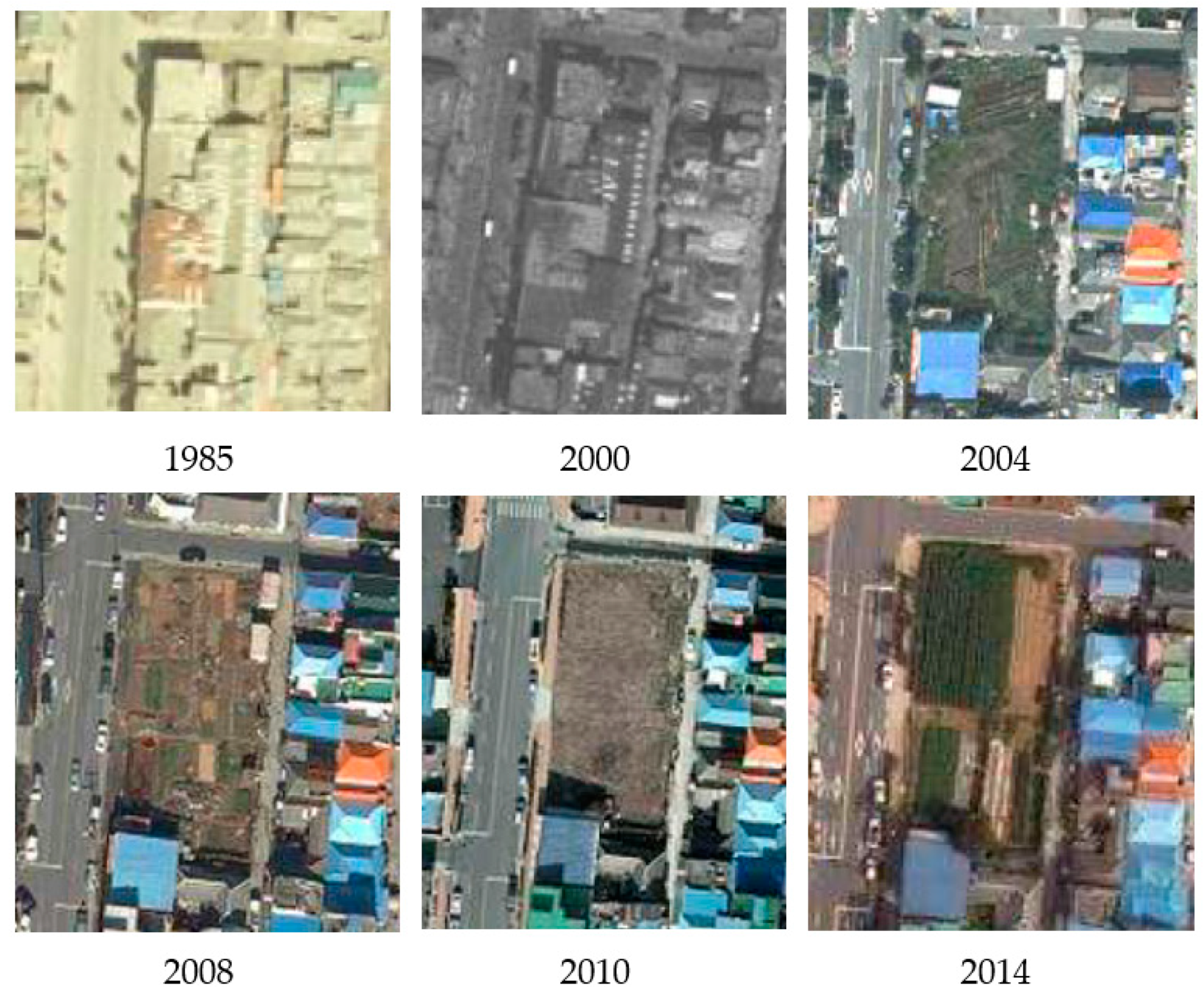
Site B (Figure 6) is an example that shows that the adverse effects of unused spaces can be reduced when neighbors collectively maintain the space. A rice mill had been operating at the target site and there were plans to demolish the existing building and construct a seven-story building. However, these plans could not be completed because residents in the neighborhood opposed them based on possible structural instability. Over time, the owner sold the land, and the site had been littered with rebars and concrete. The land remained abandoned and became covered in thick grass. As the environment continued to deteriorate, neighborhood residents began to clear away rocks, rebars, and grasses on the abandoned site, and occupied it after converting it into a farm using briquette as a fertilizer. However, the farming activities stopped when a nearby resident purchased the land in 2010 (refer to Figure 7, 2010). The new owner allowed her neighbor to use the land and received crops in return. Because the farming activities had increased, the owner had been receiving KRW 1.1 million per year for several years.
Although the unused space was rented and used as a farm, the adverse effects (e.g., littering) of an abandoned, unused space were observed. The tenant requested that the neighbors not litter and watch the space for him, but the situation did not improve. Therefore, the tenant provided parts of the land to people living adjacent to the site, allowing them to cultivate crops for free and mitigating the litter problem (Figure 6). As a result, the outskirts of the site had small vegetable gardens, which were used as extensions of living spaces such as for drying laundry and preparing foods on chairs. Moreover, it was expanded as a space for sharing personal stories and doing chores together.
“It was full of grass like a mountain. Although it was not my land, we cut the grass, cleaned garbage, took rocks out, and poured soil. I felt offended because we were not allowed to use it after he rented it out for money. However, it is okay now because he gave us some parts of the land and we can grow green onions or other vegetables.”—User C (female, aged in her 70s)
Site B posed a risk of conflict due to changes in the occupation method. However, the tenant’s autonomous rules and engagement allowed him to overcome resistance or friction against these changes. Securing common pool resources is essential in increasing social capital in the communities in which we live [21]. Although the unused space was privatized through renting, the tenant voluntarily shared a portion of the space to cancel out the exclusion of private property. Therefore, many residents in the neighborhood could access it easily, and it became a space for public use.
3.3. Conversion of Unused Spaces through Negotiation and Collective Consciousness
Unused space Site C (Figure 8) was occupied by neighbors who did not have permission to cultivate food. The space was left unattended because the landowner lived somewhere else, and the neighbors occupied it to create a vegetable garden. After their unauthorized occupation, they experienced conflicts with the landowner. However, they continued to occupy the unused site after negotiating with the landowner, to whom they gave some of the harvested vegetables.
The owner had not allowed them to use the land, and became very angry when he first discovered his land was being used as a vegetable garden, and asked who was using it. The occupant, who was absent at the time, found out about this later. The occupants delivered harvested vegetables and provided a small amount of vegetables to the owner whenever they occasionally encountered him.
“I live in Daecheon-myeon. One day, I came to visit my land and found out that someone else was using it as a vegetable garden. I asked my friend, the owner of the restaurant in front of it, who was using it, and found that the next-door neighbor was using my land. I visited the neighbor in question, but could not meet him because he was not available at that time. My friend told him about it, and the man gave me the vegetables he harvested from my land. I live far away. No one is willing to build a house and live here, so I just told them to give me crops occasionally and allowed them to use the land.”—Owner C (female, aged more than 70 years)
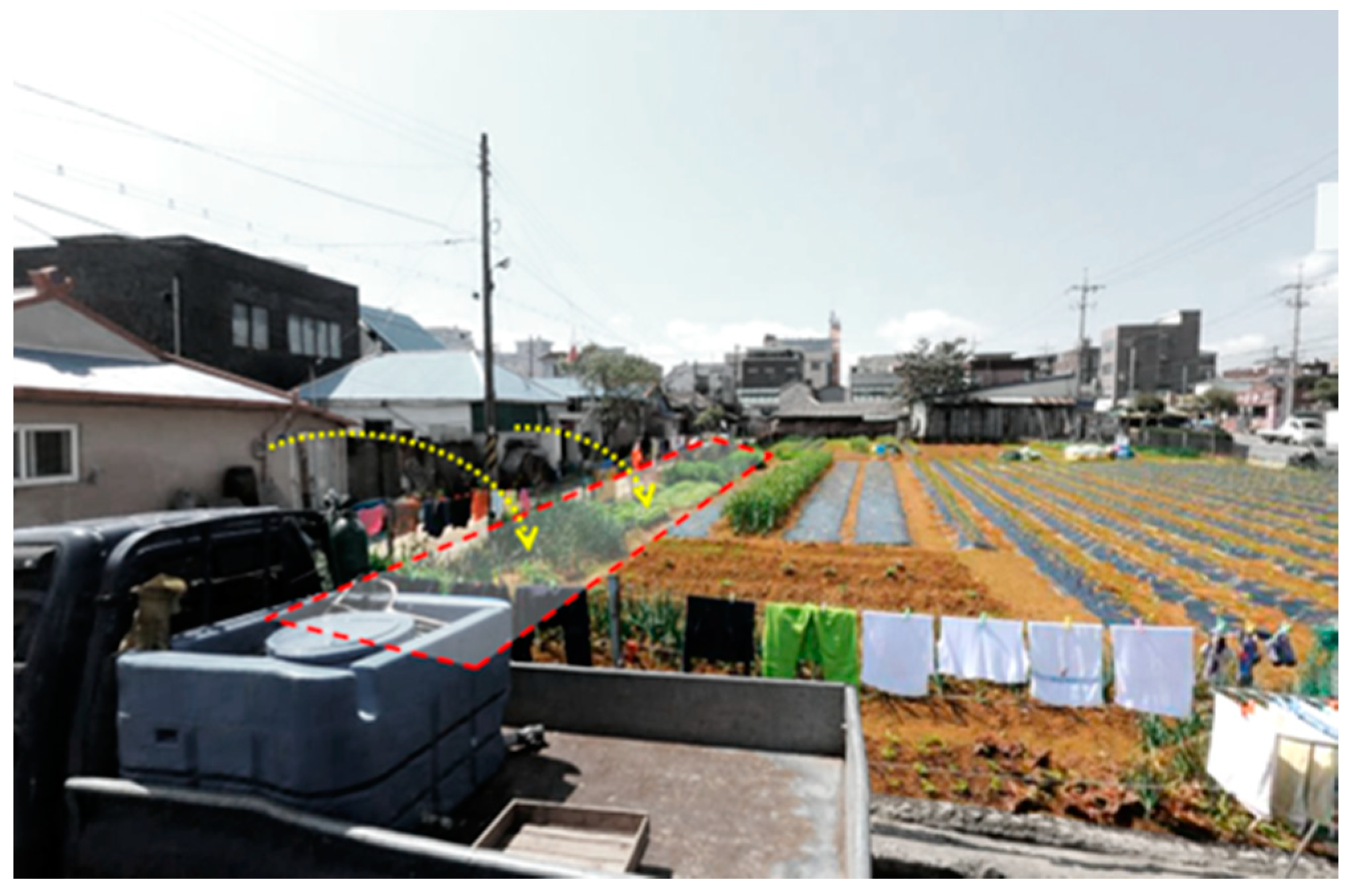
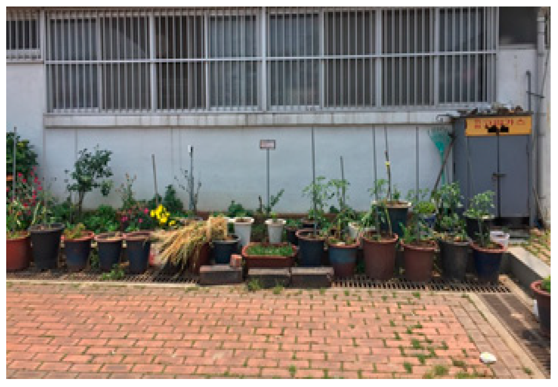
Target Site C was converted into an unused space after a building in the private lot was demolished. Around the same time, an old building next to it was purchased by the military and turned into a public parking lot. Because the vacant house facing the site was also converted into a parking lot, the residential environment worsened (refer to Figure 9). However, the occupant improved the environment by displaying the crops harvested from the unused space in pots and sharing the pleasing aesthetic with neighbors.
The land user was a senior citizen aged more than 80 years. He initially used the space to grow crops, which became his hobby; thus, he enjoyed observing the growing plants and the changing land. He became interested in taking care of the land, and created a flower garden and placed nametags and dates on the plants to observe their changes. He wanted to take care of the unused space and share his hobby with passers-by because an adjacent unused space was converted into a parking lot. He transplanted vegetables and flowers in small pots and displayed them at the edge of the parking lot to share his hobby.
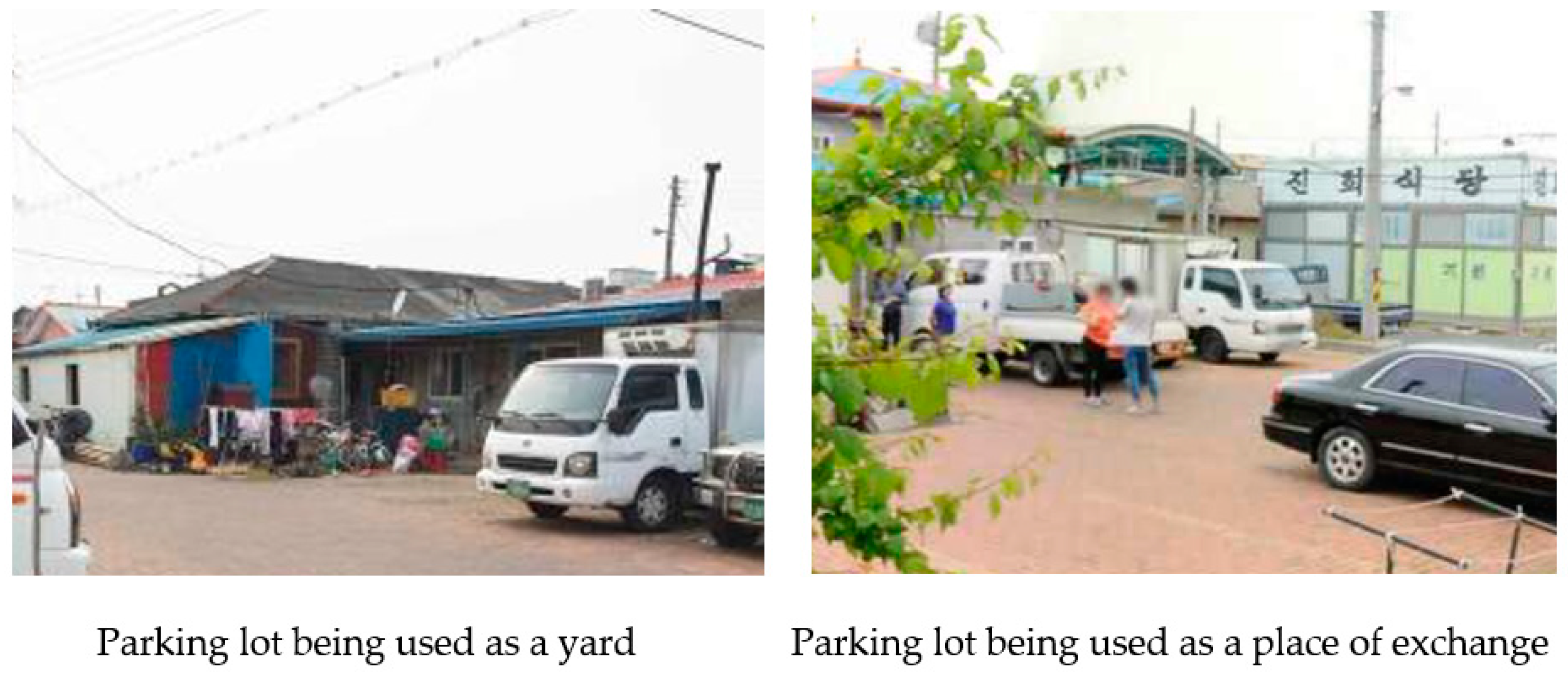
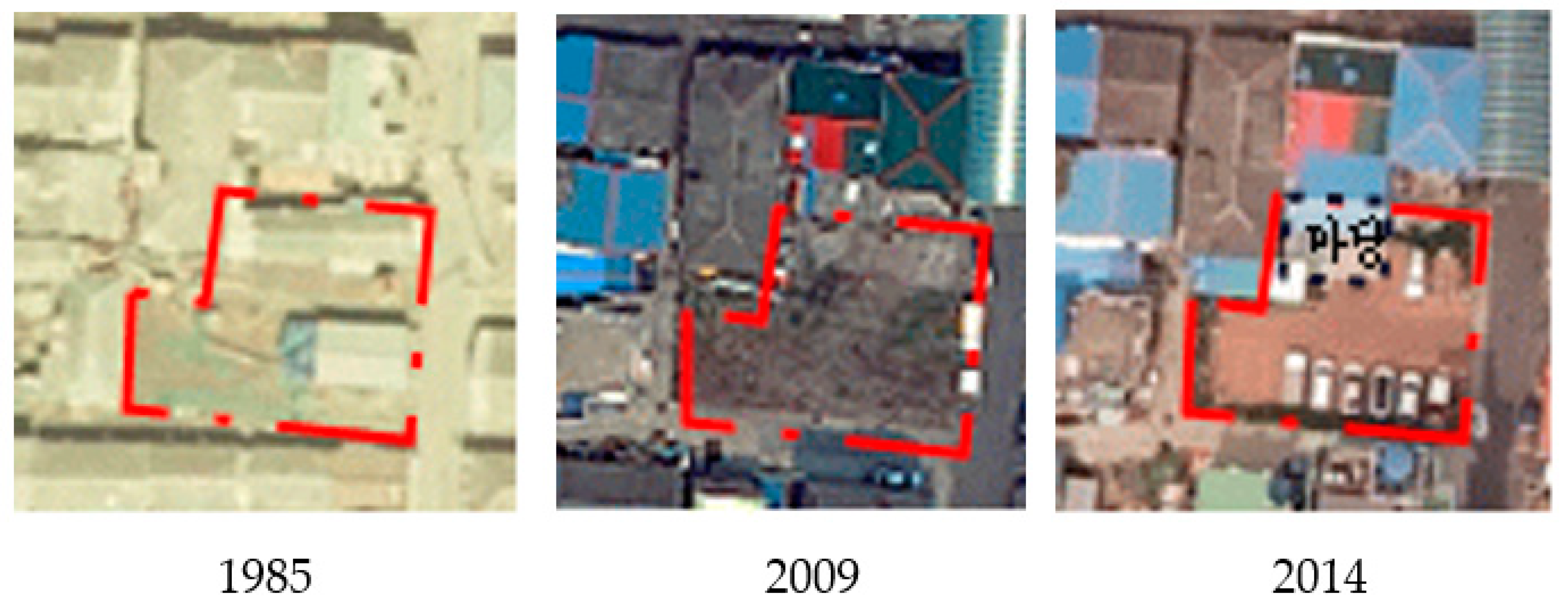
In a similar case, a traditional market was located on the unused space Site D (Figure 10). Seocheon-gun officials purchased vacant houses and converted them into a parking lot because Site D did not have sufficient parking space (Figure 11). Because it was located in an old residential area with dense housing, the parking lot constructed after the vacant houses were demolished was located next to other houses. Residents living near the parking lot were experiencing much smoke and noise from the parking lot. When there was no parked vehicle, the parking lot was used as a yard. Moreover, Mr. Choi, who did not have a family, converted the negative atmosphere of the environment into a positive one by greeting passers-by.
4. Discussion
The results of the study show that the majority of the private unused spaces in the target area were occupied by other residents in the neighborhood and used for other purposes. Because they were occupied by private parties, the unused spaces were well maintained without the need for the urgent management of issues such as odors or bugs caused by littering. This phenomenon differs from the reported adverse effects observed in abandoned unused spaces. The study results reveal that the space can be managed through an implicit agreement regarding occupancy based on stakeholders’ purposes. These spaces can be managed through a flexible negotiation process and sense of mutual sharing among stakeholders.
In the age of low growth and population decline, cities have to be passive in developing unused spaces because of decreased tax revenues and investment in the region. As a result, private areas have been neglected. Conflicts between residents regarding unused spaces may worsen. The results of the study indicate that these conflicts can be alleviated through negotiations and a sense of community. On the other hand, although stakeholders occupied the unused space through unofficial occupation activities with the implicit consent of other stakeholders, conflicts intermittently emerged. It is necessary to prepare institutional arrangements that can lead to the legalization of unofficial occupation activities to help alleviate these conflicts. As evinced by Philadelphia’s Community LandCare Program and Cleveland’s Garden Boyz program, unused spaces can be successfully managed if a system suitable for an urban situation is found. It will be possible to manage unused spaces successfully in Janghang through a system that legalizes voluntary acts. However, it is challenging for young people to continuously participate in a small city like Janghang, the focus of this study. Moreover, as Janghang has a high proportion of old people, a system legalizing voluntary acts is a constant and realistic alternative.
If institutional arrangements are set to regulate the voluntary actions of residents, the coexistence of public and regional institutions as well as of residents can be promoted because it will stabilize land use, mitigate the adverse effects of spaces remaining unused, and economically benefit residents. Landowners and occupants are different in shrinking cities, and potential conflicts exist between them. Therefore, social disputes and conflicts arising during the management of unused spaces can only be resolved when the relationships between stakeholders are considered along with the spatial and physical environment. Because social conflicts regarding unused spaces are related to the conditions of these spaces and the neighboring environment, arbitration between stakeholders is a key factor in the management of unused spaces and landscapes in shrinking cities.
This paper provided a detailed discussion of the process of converting unused spaces based on selected sites in Janghang. However, there are some limitations such as regional specificity in extrapolating and generalizing the results to all shrinking cities. Regardless, it is believed that the results of this study will offer substantial implications to 224 small and medium-sized provincial cities that are similarly sized to Janghang in South Korea, and to others around the world. Additionally, this study supplemented the existing perspective by accepting informal behavior as the management of the landscape. Future studies must evaluate the conversion process of unused spaces in provincial cities that feature various attributes of shrinking cities.
Funding
This research received no external funding.
Acknowledgments
This manuscript was prepared by modifying and supplementing a portion of the Ph.D. dissertation titled “Conversion Process of Vacant Land in a Shrinking City—A Case Study of Janghang-eup in Chungcheongnam-do” and presented by Jin-Wook Lee at Seoul National University.
Conflicts of Interest
The authors declare no conflict of interest.
References
- Spelman, W. Abandoned buildings: Magnets for crime? J. Crim. Justice 1993, 21, 481–495. [Google Scholar] [CrossRef]
- Stucky, T.D.; Ottensmann, J.R. Land use and violent crime? Criminology 2009, 47, 1223–1264. [Google Scholar] [CrossRef] [Green Version]
- Accordino, J.; Johnson, G.T. Addressing the vacant and abandoned property problem. J. Urban Aff. 2000, 22, 301–315. [Google Scholar] [CrossRef]
- Han, H.S. The impact of abandoned properties on nearby property values. Hous. Policy Debate 2014, 24, 311–334. [Google Scholar] [CrossRef]
- Choi, B. Cultural regeneration of American military base under-used spaces: Focusing on the regeneration project of camp Greaves. Hum. Contents 2017, 46, 203–226. [Google Scholar] [CrossRef]
- Hwang, D.H. A Study on the Space Design Policy for the Cultural Regeneration of Idle Space in Korea. Ph.D. Thesis, Seoul National University, Seoul, Korea, 2018. [Google Scholar]
- Baek, J.; Jang, H.; Hong, D. A study to develop unused space on the area of Wangsimni subway station. Appl. Geogr. 2014, 12, 67–85. [Google Scholar]
- Ha, C.H.; Kwak, H.J.; Kim, H.S. A study on utilization and making vegetable garden of vacant land and deserted house in deteriorated low-rise residential area for neighborhood regeneration—Focused on No-Song low-rise residence district in Jeonju. J. Urban Des. Inst. Korea 2013, 14, 81–93. [Google Scholar]
- Kim, K.J. Causes and consequences of urban decline in Korean cities. Korean Urban Geogr. Soc. 2010, 13, 43–58. [Google Scholar]
- Kim, J.Y.; Lee, Y.S. A study on design direction of community garden in urban deprived area through analysis of psychological and social effects—Targeting on the community garden of Jeonju-si urban regeneration test-bed area. Des. Converg. Stud. 2013, 12, 83–98. [Google Scholar]
- Branas, C.C.; Cheney, R.A.; MacDonald, J.M.; Tam, V.W.; Jackson, T.D.; Ten Have, T.R. A difference-in-differences analysis of health, safety, and greening vacant urban space. Am. J. Epidemiol. 2011, 174, 1296–1306. [Google Scholar] [CrossRef] [PubMed] [Green Version]
- Garvin, E.C.; Cannuscio, C.C.; Branas, C.C. Greening vacant lots to reduce violent crime: A randomised controlled trial. Inj. Prev. 2013, 19, 198–203. [Google Scholar] [CrossRef] [PubMed]
- Rall, E.L.; Haase, D. Creative intervention in a dynamic city: A sustainability assessment of an interim use strategy for brownfields in Leipzig, Germany. Landsc. Urban Plan. 2011, 100, 189–201. [Google Scholar] [CrossRef]
- Oswalt, P.; Rieniets, T.; Global Context. Shrinking Cities. 2007. Available online: http://www.shrinkingcities.com/globaler_kontext.0.html?&L=1 (accessed on 7 November 2017).
- Harvey, D. Spaces of Hope; University of California Press: Berkeley, CA, USA, 2000. [Google Scholar]
- Lee, H.; Han, S. Where Do Shrinking Cities Go from Here? Korea Research Institute for Human Settlements: Yanyang, Korea, 2014. [Google Scholar]
- PHS. Philadelphia LandCare Program. Available online: https://phsonline.org/programs/transforming-vacant-land (accessed on 24 April 2020).
- Heck, A.; Will, H. Interim use: Opportunity for new open-space quality in the inner city—The example of Leipzig. Ger. J. Urban Stud. 2007, 46. [Google Scholar] [CrossRef]
- Glöckner, B.; Turn, T. Lückenlösungen–Zwischennutzungen im Stadtumbau; PlanerIn: Berlin, Germany, 2004. [Google Scholar]
- Gstach, D. Temporary open spaces as incubator for social integration. In Proceedings of the 45th International Making Cities Livable Conference, Portland, OR, USA, 10–14 June 2007. [Google Scholar]
- Bontje, M. Facing the challenge of shrinking cities in East Germany: The case of Leipzig. GeoJournal 2005, 61, 13–21. [Google Scholar] [CrossRef]
- Cabral, I.; Weiland, U. Urban Gardening in Leipzig and Lisbon: A Comparative Study on Governance; COST (European Cooperation in Science and Technology): Leipzig, Germany, 2014. [Google Scholar]
- Lewis, M.; Conaty, P. The Resilience Imperative: Cooperative Transitions to a Steady-State Economy; New Society Publishers: Gabriola, BC, Canada, 2012. [Google Scholar]
- Statistics Korea. 2015 Annual Population and Housing Census. Available online: http://kosis.kr/statisticsList/statisticsListIndex.do?menuId=M_01_01&vwcd=MT_ZTITLE&parmTabId=M_01_01 (accessed on 24 April 2020).
- Korea Appraisal Board. Available online: http://www.kab.co.kr (accessed on 24 April 2020).
- Local Finance Integrated Open System. Available online: http://lofin.mois.go.kr/portal/main.do (accessed on 24 April 2020).
- National Geographic Information Institute. Available online: https://www.ngii.go.kr/eng/main.do (accessed on 24 April 2020).
- Daum Map. Available online: https://map.kakao.com (accessed on 24 April 2020).
Figure 1.
Current utilization of unused spaces.

Figure 2.
Subjects transforming unused spaces.

Figure 3.
Locations of study sites.

Figure 4.
Entire view of Site A. Source: Photo taken by the researcher (December 2016).

Figure 5.
Satellite images showing the changes at target Site A. Source: National Geographic Information Institute [27] and Daum Map (2016) [28].

Figure 6.
Entire view of Site B. Note: The outskirts of the target area were provided to nearby residents and used as their living space. Source: Photo taken by the researcher (December 2016).
Figure 6.
Entire view of Site B. Note: The outskirts of the target area were provided to nearby residents and used as their living space. Source: Photo taken by the researcher (December 2016).

Figure 7.
Satellite images showing changes at target Site B. Source: National Geographic Information Institute [27].
Figure 7.
Satellite images showing changes at target Site B. Source: National Geographic Information Institute [27].

Figure 8.
Flowerbed at unused Site C cared for by an occupant. Source: Photo taken by the researcher (May 2016).
Figure 8.
Flowerbed at unused Site C cared for by an occupant. Source: Photo taken by the researcher (May 2016).

Figure 9.
Satellite images showing the changes at target Site C. Source: National Geographic Information Institute (1985 and 2017) [27] and Daum Map (2016) [28].

Figure 10.
Entire view of Site D. Source: Photos taken by the researcher (May 2016).

Figure 11.
Satellite images showing changes at target Site D. Source: National Geographic Information Institute [27].
Figure 11.
Satellite images showing changes at target Site D. Source: National Geographic Information Institute [27].


Table 1.
Changes in Janghang’s population (sociodemographic aspect).
| Classification | Period | Changes Compared to the Past | |||||
|---|---|---|---|---|---|---|---|
| 1970 | 1980 | 1990 | 2000 | 2010 | 2015 | ||
| Population | 25,521 | 30,861 | 23,358 | 16,278 | 13,468 | 11,549 | −50.6% |
| Population over age 60 | 1142 | 1694 | 2147 | 2856 | 3429 | 3815 | +334.1% |
| Ratio (%) | 4.5 | 5.5 | 9.2 | 17.5 | 28.7 | 32.4 | |
| Population under age 14 | 11,267 | 11,496 | 5577 | 3166 | 1789 | 2063 | −81.6% |
| Ratio (%) | 44.1 | 37.2 | 23.8 | 19.4 | 13.2 | 17.8 | |
Source: Population and Housing Census (Statistics Korea [24]). Note: (1) Based on the elderly (≥60 years old) and fertile women (ages 15−49), (2) population change compared to the past: the current rate of population increase or decrease compared to the period when the population was the highest in the last 30 years.
Table 2.
Rate of change in price of the land (industrial economic aspect).
| Year | Rate of Change in Price of the Land | Self-Reliance Ratio |
|---|---|---|
| 1975 | 26.26 | - |
| 1980 | 11.03 | - |
| 1990 | 11.23 | - |
| 2000 | 2.34 | - |
| 2010 | 0.40 | - |
| 2016 | 1.53 | 17.22 |
Table 3.
Study methods.
| Study Content | Study Methods | Study Materials |
|---|---|---|
| (Research Questions) | ||
| Motivation and purpose of the transformation of private unused spaces | •Literature review | Demolition and destruction management ledger, building cancellation ledger, vacant houses organization project, list of beneficiaries, real estate certificate, and stakeholder interviews |
| Factors affecting the transformation of unused spaces | •In-depth interview | |
| •Field survey | ||
| Dynamics with stakeholders | •Literature review | Institution, local newspaper, and government office press release |
| •In-depth Interview | Stakeholder interviews |
Table 4.
Participant list.
| Target Area | Classification | Participant | Gender (Age) | |
|---|---|---|---|---|
| 1 | A | User | A | Male (60s) |
| 2 | B | Male (70s) | ||
| 3 | C | Female (70s) | ||
| 4 | D | Female (70s) | ||
| 5 | E | Male (70s) | ||
| 6 | F | Male (70s) | ||
| 7 | G | Female (70s) | ||
| 8 | H | Male (80s) | ||
| 9 | Owner | I | Male (40s) | |
| 10 | Manager | J | Male (60s) | |
| 11 | K | Male (50s) | ||
| 12 | L | Male (50s) | ||
| 13 | B | Leaser | A | Male (60s) |
| 14 | User | B | Female (60s) | |
| 15 | C | Female (70s) | ||
| 16 | D | Female (70s) | ||
| 17 | C | User | A | Female (70s) |
| 18 | B | Female (80s) | ||
| 19 | Owner | C | Female (70s) | |
| 19 | D | User | A | Male (80s) |
| 21 | Resident | B | Male (70s) |
Table 5.
Major questions.
| Occupation Process | What motivated you to use this vacant lot? |
| What was the condition of the lot before you occupied it? | |
| How long have you been occupying the lot? | |
| Why have you continued to occupy the lot? | |
| Relationship between Owners and Neighborhoods | Do you know the owner of the vacant lot? |
| Have you faced any issues with the neighborhood? |
© 2020 by the author. Licensee MDPI, Basel, Switzerland. This article is an open access article distributed under the terms and conditions of the Creative Commons Attribution (CC BY) license (http://creativecommons.org/licenses/by/4.0/).
Share and Cite
MDPI and ACS Style
Lee, J.-W. Transforming Unused Spaces in a Shrinking City through Individuals’ Spontaneous Occupation Activities: The Case of Janghang, South Korea. Sustainability 2020, 12, 6621. https://0-doi-org.brum.beds.ac.uk/10.3390/su12166621
AMA Style
Lee J-W. Transforming Unused Spaces in a Shrinking City through Individuals’ Spontaneous Occupation Activities: The Case of Janghang, South Korea. Sustainability. 2020; 12(16):6621. https://0-doi-org.brum.beds.ac.uk/10.3390/su12166621
Chicago/Turabian StyleLee, Jin-Wook. 2020. "Transforming Unused Spaces in a Shrinking City through Individuals’ Spontaneous Occupation Activities: The Case of Janghang, South Korea" Sustainability 12, no. 16: 6621. https://0-doi-org.brum.beds.ac.uk/10.3390/su12166621
Note that from the first issue of 2016, this journal uses article numbers instead of page numbers. See further details here.