Article

Knowledge and Practices of Indigenous Peoples in the Context of Resource Management in Relation to Climate Change in Southeast Asia

Institute Cultural Anthropology and Development Sociology, Faculty of Social Science, Leiden University, Wassenaarseweg 52, PO Box 9555, 2300 RB Leiden, The Netherlands
*
Author to whom correspondence should be addressed.
Sustainability 2020, 12(19), 7983; https://0-doi-org.brum.beds.ac.uk/10.3390/su12197983
Submission received: 21 July 2020 / Revised: 4 September 2020 / Accepted: 21 September 2020 / Published: 26 September 2020

Abstract

:
In this article, we document how four indigenous peoples in insular Southeast Asia (Indonesia and the Philippines) have reacted to external interventions and discuss to what extent climate change has been a factor in the adjustment of their way of life. All groups share a similar environment, that is tropical low land rainforest. However, their traditional modes of exploitation of this environment vary, which can be ascribed to specific geographical and cultural characteristics. In recent years, these indigenous peoples have faced encroachment of their lands through logging and mining activities and the arrival of migrants looking for arable lands. They have developed various ways to cope with the changing conditions, ranging from efforts to retreat into the remaining rainforest to increased resource extraction and losing a long-term interest in the sustainability of their home territory. The younger generation seems to take a different stand towards their future in relation to their natural environment and the way of life of their ancestors. Though there can be no doubt about climate change in the context of insular Southeast Asia, this change is difficult to differentiate from the cumulative environmental impacts brought about by other forms of anthropogenic change, notably forest degradation. Examples that will be discussed in this article are the Agta of Northeastern Luzon in the Philippines, and the Orang Rimba, the Mentawaians, and the Ngaju Dayak in Indonesia.

1. Introduction: Indigenous Peoples in Tropical Lowland Rainforests in Southeast Asia

Southeast Asia is home to a large diversity of indigenous peoples in a wide range of environmental conditions. Though they are often grouped together in terms of their socio-political status as relatively weak and marginal communities within the present nation-states, there are many ways to differentiate between them on the basis of modes of livelihoods, or specific cultural, religious, or linguistic characteristics [1,2]. Here, we focus on four of these groups in order to discuss the present-day challenges that they face as a result of climatic changes, in addition to the impacts of other types of environmental changes brought about by human interventions.
In this article, we discuss some of the practices and the related knowledge about the natural environment and its resources of four indigenous groups in insular Southeast Asia, namely the Agta in the Philippines, and the Orang Rimba, Mentawai, and Ngaju Dayak in Indonesia. We focus on the way these peoples have reacted to external interventions in their home territories and discuss to what extent climate change has been a major factor in the need for adjustment of their way of life. All groups share a similar environment, that is tropical lowland rainforest, with or without a coastal zone. However, their traditional modes of exploitation of this environment have differed substantially, which can partly be ascribed to its specific characteristics at various locations as well as to the cultural characteristics of these ethnic groups.
The majority of the indigenous peoples in Southeast Asia practice some form of shifting agriculture in either lowland, hilly, or even mountainous environments. Within this group, there are big differences in terms of crops cultivated, and specific methods of practicing this form of land use [3]. In some cases, they also combine shifting agriculture with permanent agriculture, for instance for the cultivation of particular fruit trees or cash crops. There are also relatively small groups of hunter-gatherers to be found in the region’s lowland rainforests. Their numbers and densities are always low. To a large extent they hunt, fish, and collect a wide range of products for their own subsistence, but all of them are also involved in the harvesting of non-timber forest products (NTFPs) for commercial purposes and exchange with traders. As hunting and gathering alone usually no longer provide a sufficient basis for their living, most of these groups also engage in small-scale agriculture (usually shifting cultivation), as well as casual labor [4].
Practices of shifting cultivation have often been described in negative terms. Colonial and national government officials in many countries considered this form of using forest resources as being wasteful and inefficient [5]. Policies were formulated to turn these forest cultivators into permanent agriculturalists. A recent volume in a series of books on shifting cultivation, edited by Malcolm Cairns [6], about Shifting Cultivation Policies, which provides numerous case studies from a wide range of countries, proofs this point again. However, scientists of various disciplines, inspired by the monumental work of Conklin [7], have looked into these practices in closer detail and they have reached a different conclusion. They consider the shifting cultivation practiced by many forest-based indigenous communities as being a highly efficient and sustainable way of using available resources, which does not harm forest resources in the long run. In contrast, there are clear indications that small-scale shifting cultivation can positively affect forest biodiversity. This is evident, for instance, from the high number of useful plants and animals that are the result of selective cultivation and breeding [8]. On the other hand, there are also examples in which indigenous communities have overexploited particular plants or animals often because of their commercial value for external markets. An interesting case is how the demand for agarwood (also known as eaglewood or gaharu) has brought some Aquilaria species, that produce this valuable product to the point of extinction in many forested areas in Southeast Asia [9].
In addition, there is now widespread recognition of the extensive indigenous knowledge about forest ecosystems, including its diversity of plants and animals, soil types, and fertility. The attention for and interest in such knowledge systems has increased very much in recent decades. In fact, various branches of ethno-science, like ethno-ecology, ethno-botany, and ethno-zoology have developed. Of particular interest is also the knowledge and use of medicinal plants by indigenous peoples, which has turned out to be of great value for the development of a wide range of medicines [10]. In addition to this extensive ecological knowledge, many indigenous communities hold knowledge or memories about specific natural hazards, like earthquakes, volcano eruptions, or tsunamis, and this knowledge tends to be passed on to next generations through narratives and oral traditions [11].
In contrast, knowledge about various aspects of climatic conditions and climate change among forest dwelling communities in Southeast Asia appears to be less elaborate, apart from the interpretation of particular indicators of relatively short-term future weather conditions [12,13]. Beyond the experience of extended drought or excessive rainfall, there are few references in indigenous knowledge systems about awareness of long-term variability in temperature or rainfall. This relative absence of knowledge of gradual climatic changes may in itself not be surprising as, especially in the wet tropics, such changes are usually only noticeable on the basis of systematic records kept over extended periods of time. In case these changes become more extreme, like the frequency and intensity of tropical storms, floods, or mudslides, local awareness of them will likely increase.
In other climate zones, where the climatic changes are more evident or pronounced, local knowledge on such changes appears to be more elaborate. Moreover, perceptions of such change by local and indigenous communities have turned out to be quite consistent with studies of climate change based on data collected through the use of instruments. Savo et al. [14] provide an interesting meta-analysis of climate changes observed by hundreds of subsistence-oriented communities from around the globe. This study confirms once more the relevance of traditional ecological knowledge in studying ecosystems including the impact that changes of whatever kind have on the environment and their livelihoods.

Approach and Methods

The case studies are based on fieldwork by the authors over an extended period of time, while three PhD students, who are supervised by the authors, have conducted fieldwork more recently. Their work is referenced in the case-studies. The aim of the case studies is to look closer at the combined and often cumulative impact of climate change and other environmental changes as a result of logging activities and other types of resource use.
The description of these case studies is based on ethnographic fieldwork by the authors in the context of various research projects, and their involvement as researchers or consultants in a number of conservation and/or development projects. Fieldwork among the Agta was conducted by the second author for a total of 9 months spread out between 2002 until 2005, which was continued with short, yearly field visits until 2014. Fieldwork among the Orang Rimba was done by the first author in July–August in 1983, from August until December 1985, during short visits of one to three weeks in 1988, 2000, and 2005, and during a joint visit by both authors in 2013. The fieldwork on Siberut was done by the first author from September 1979 until January 1982, from December 1984 until July 1985, and during shorter visits of one to four weeks in 1986, 1988, 1994, 2002, 2004, 2009, and 2013. Fieldwork among the Ngaju Dayak was done by the first author in September–October 2002, May–June 2004, November 2004, June 2005, and July 2011.
The long-term insights presented in this article are derived from this ethnographic fieldwork. The methods used during these fieldwork periods are a combination of participant observation, qualitative interviews, and structured interviews with local informants from the indigenous peoples that we describe, as well as interviews with field officials, missionaries, representatives of NGOs, staff of logging and mining corporations, and development workers. Secondary sources, including company reports, and data from local government offices were also part of this knowledge base. Insights from these primary and secondary sources have been used in combination with the relevant scientific literature.

2. Climatic Change in Southeast Asia

Over the past two decades numerous reports, including those of the International Panel of Climate Change (IPCC), have been published about climatic change in Southeast Asia [15]. The information contained in these reports has also been used to produce Global Climate Model (GCM) outputs in order to be able to assess the impact of climatic change and to suggest options for adaptation measures. In general, the literature about Southeast Asia shows a high level of agreement on observed climate change and its impacts. Of course, there is also substantial variation within the region given the size of the area and the prevailing climatic conditions. It is not the purpose of this article to discuss the wealth of available data in detail, but here we highlight the main trends and projections for the region [16,17,18].
Differences in rainfall patterns and the occurrence of typhoons predated the present-day climatic changes. In large parts of Southeast Asia, the climate extremes which have been known for a long time, such as El Niño and La Niña, are likely to increase in scope and frequency, leading to higher risks of extended periods of drought as well as heavy rains and therefore floods. Increase in surface temperature has already exceeded 1 °C during the 20th century and is expected to further increase depending on future developments. Making general statements about changes in annual precipitation is difficult, as there are substantial differences between and even within countries. In Indonesia for instance, some areas have experienced an increase in rainfall in recent years, while in others it has reduced. This change has not been homogeneous. In the future, the Philippines will most likely be hit by a larger number of typhoons, which might also increase in relative strength, bringing increased amounts of rainfall [19,20].
The impacts of climate change are felt in various sectors. Agricultural productivity is severely influenced by the longer dry seasons caused by El Niño. Increasing sea water temperatures are likely to affect aquaculture along the coasts of the Philippines, Vietnam, and Indonesia. The extensive periods without rainfall are likely to increase the risk of forest fires. This is particularly problematic in the peat land forests of Borneo and Sumatra, large parts of which have recently been drained for establishing commercial plantations, contributing also to biodiversity loss. Heavier and excessive rainfall, on the other hand, may lead to floods, thereby destroying both agricultural land as well as settlements and infrastructure, notably roads and bridges. Human health will be impacted as well: vector borne diseases such as malaria, and dengue fever will be spreading as a result of stagnant water. Availability of drinking water will become a problem during drought periods. Particularly low-lying areas close to the coast may suffer from inundation and salt water intrusion, which will then also threaten agriculture and drinking water facilities. This may be aggravated by sea level rise, predictions for which vary across the region, but which is already threatening parts of Vietnam and Indonesia. Coral reefs will be affected by the rise in temperature [17,19,20].
Many of these phenomena are well-known by now and they have become subject to various policy measures. Examples are the ban on the use of fire as an instrument in forest management or in the process of conversion to other types of land use (to avoid wild fires), the rehabilitation of degraded peat swamp forests (to avoid further drainage) and the reduction of conversion of mangrove forests into shrimp ponds (to avoid coastal erosion and coral bleaching) [17]. A range of management and financial instruments have been designed to cope with these problems, including the Clear Development Mechanisms (CDM), which provide financial means for taking positive environmental action. This includes compensation for not doing particular things, as is the case for REDD+ (Reducing Emission from Deforestation and Forest Degradation, with the addition of biodiversity). This program compensates owners or managers of a forest area for abstaining from logging, or for the additional costs arising from biodiversity conservation [21].
REDD+ has been criticized for its lack of efficacy, which stems from challenges regarding the governance of these schemes and the complex web of agencies, right claimers and other stakeholders involved. In some cases, large scale land acquisitions and efforts to protect the ecosystem through REDD+ strategies may even compete for the same area [21]. Another important point of criticism relates to the additional impacts that these schemes have on indigenous communities’ well-being. These impacts are most directly felt with respect to the landscapes, and the plant and animal life on which their livelihood is based. The REDD+ program serves as one of the most important examples of how climate change mitigation measures often limit local and indigenous communities’ access to natural resources. Limitations also tend to include prohibitions on shifting agriculture. As a result, food procurement has to change, which often has far-reaching social consequences, including changes in division of labor within communities and households. Knowledge and skills that were essential for traditional tasks, may become less important under such conditions [22,23,24]. Such experiences should form the basis for reconsidering the way REDD+ projects are being implemented as well as the impact such projects have on local livelihoods [25].
The indigenous peoples inhabiting the tropical lowland forests of Southeast Asia have been faced with large scale changes over the last few decades, of which the ongoing process of climate change is only one. Though some areas were already converted into plantations for cash crops like rubber and palm oil in the first decades of the 20th century, it was mainly in the 1970s and 1980s that the scale on which activities like logging, mining, and conversion took place and became much larger. In combination with more powerful technology (chainsaws, bulldozers, and skidders), the construction of roads facilitated the extraction of other resources like coal, iron ore or minerals. These road networks also facilitated the arrival of people in search of arable land in areas that were often considered as being ‘empty land´ [8,26]. As a result of these activities, the landscape of the tropical lowland forests of Southeast Asia has been described as a mosaic of land use types, in addition to the traditional forms of land use by the indigenous population [27]. When zooming in on individual countries, or even regions within countries, the overall picture of the forests of Southeast Asia is one of massive forest degradation or even deforestation and conversion to plantations. The FAO/UNEP’s annual publication on the State of the World’s Forests clearly shows this overall trend for regions and countries like the Philippines, Indonesia, Malaysia, Vietnam, and Cambodia [28]. Numerous and more detailed individual country studies confirm this trend. Though there is also a gradual increase in the number of protected areas, as national parks or areas with another conservation status, the contrast with their adjacent areas is getting more and more obvious in terms of the type and quality of the vegetation cover and biodiversity. Increasingly such protected areas become ‘islands’ without ‘bridges’, corridors, or connections with other conservation areas [29,30,31].
Compared to climate change, the impact of the large-scale forest degradation and conversion on the living conditions of the indigenous peoples is, without doubt, much more strongly felt. While the effects of climate change come gradually and may in some cases be hardly noticed by forest-dwelling communities, forest operations carried out by logging and mining companies usually have a more immediate impact with far-reaching long-term consequences. Importantly, in many cases the effects of such operations may aggravate the impact of climate change. For example, the construction of logging roads and the removal of trees results in an open canopy, which intensifies the drying of debris of the logging operations along such roads and on the forest floor during El Niño periods. Forest fires may spread more easily under such conditions, while a lowland tropical rainforest with a closed canopy and without direct sunlight on the forest floor will hardly be susceptible to rapidly spreading forest fire [29].
In the recent scientific and popular literature, as well as in the national and international policy discourse, one can easily get the impression that climate change is by far the most important cause behind the present-day problems faced by all kinds of communities across the region. However, in real life situations, the impacts of forest operations by logging, mining, and agricultural companies, are much more clearly and urgently felt. Moreover, there can be no doubt that deforestation and forest degradation generate vulnerabilities that aggravate the (future) impacts of climate change. These various impacts are thus cumulative and mutually reinforcing.

3. Indigenous Peoples, and the Cumulative Impact of Climate Change and Forest Operations

In this section, we will present the four case studies of indigenous forest dwelling communities in the Philippines and Indonesia who have experienced large scale changes in their environment, while at the same time their territories are also subject to climate change. The examples are the Agta of Northeastern Luzon in the Philippines, and the Orang Rimba, the Mentawaians, and the Ngaju Dayak in Indonesia (see Figure 1).

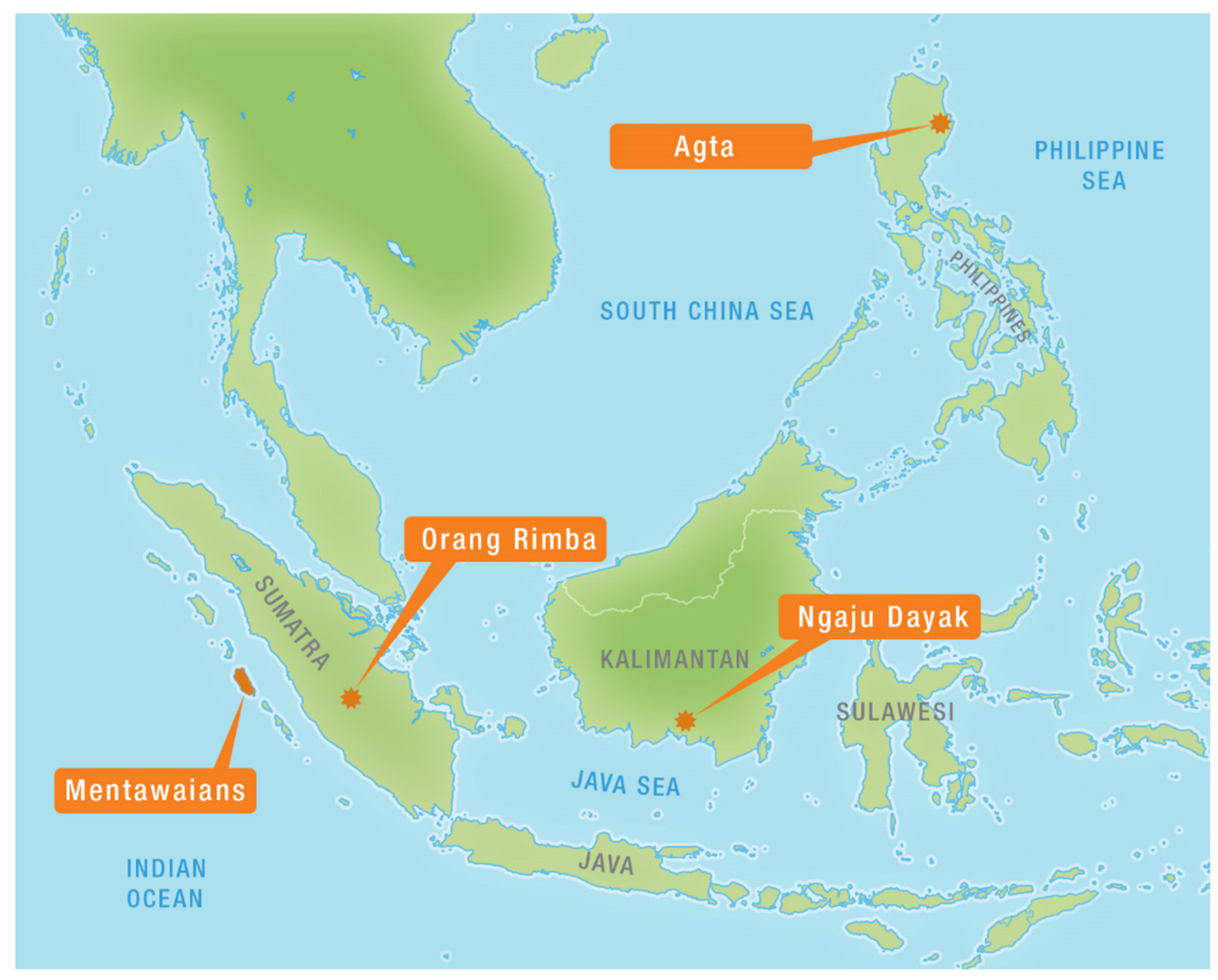
3.1. The Agta of Northeast Luzon (the Philippines)

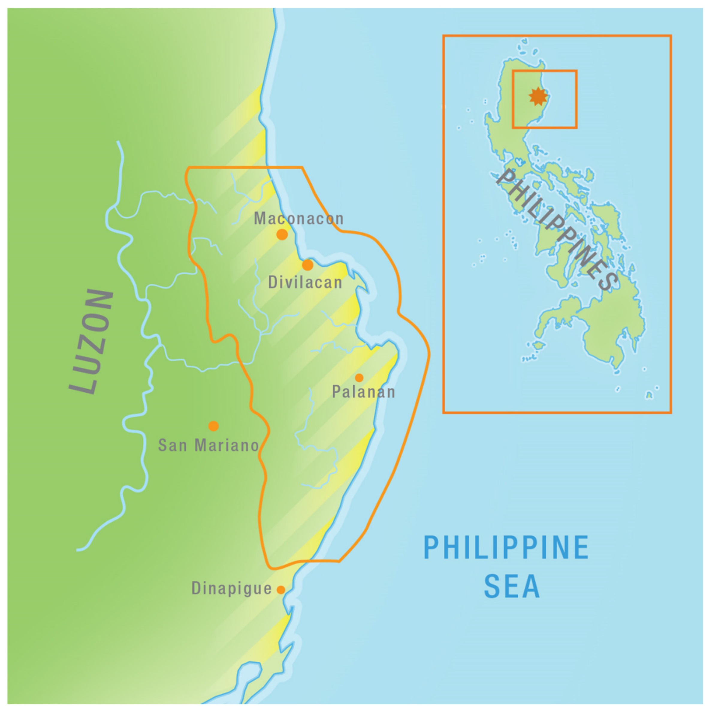
The first case that we discuss concerns the Agta (sometimes referred to as Dumagat), an indigenous population of about 10,000 people consisting of 16 linguistic groups [32]. They live in small, scattered, kin-based groups along coasts and rivers in Northeast Luzon (the Philippines). Contemporary Agta trace much of their ancestry with the Australasian peoples that first populated the archipelago, somewhere between 30 and possibly 60–70 thousand years ago [33,34]. Although they have increasingly intermarried with and partly assimilated into the Austronesian farming populations that have settled in their vicinity over the past 5000 years [35,36], part of the Agta population maintains a distinct cultural identity, social organization, and livelihood system (see Figure 2).
This is despite tremendous pressures on their natural and social environment that have arisen particularly since the 1950s. While Agta and non-Agta are thought to have maintained relatively symbiotic barter relations for hundreds of years, from the mid-20th century the demography of the hitherto sparsely population region drastically changed [37]. Large-scale and long-term logging and mining operations caused massive deforestation. These operations drew thousands of laborers, many of whom permanently settled at the logging frontier and developed farmland in previously forested areas [30]. Consequently, the Agta became a small minority in a heavily degraded environment [38]. Their situation was aggravated by the impact of armed conflict between the Philippine National Army and communist insurgents, who used the remaining forest as their hiding place [39,40]. Over the past decade, Agta groups inhabiting the coastal areas have been displaced by tourism and infrastructural development [41,42].
The impacts of these developments have in some areas led the Agta to become a new impoverished underclass of landless peasants who live on the margins of towns and villages [37]. Others retreated further into the remaining forest or stayed put on isolated coastal strips. In the remotest areas, an estimated 2000 Agta continue to live in hamlets of several closely related nuclear households away from roads, towns, and villages. They live on a combination of fishing, hunting, small-scale swidden cultivation, and the collection of forest and marine products for consumption and exchange with farmers and traders. These include a variety of freshwater and saltwater fish, crayfish and shells, game (notably deer, wild pig, macaque, monitor lizard, bats, and a range of birds [43], edible and medicinal plants [44], timber, and non-timber forest products such as honey and rattan. In addition, for almost all groups casual labor on farms, and in logging and mining concessions form an important source of income for at least a few months each year [45].
The tropical ecosystems that sustain the Agta include reefs, mangroves, lowland dipterocarp rain forests, rivers, and streams. This environment has always been heavily influenced by seasonal fluctuations in rainfall and temperature. The dry season runs roughly from February through June and comes with mean temperatures ranging from 27–29 °C and a (usually mild) wind blowing from the southwest. The wet season dominates the rest of the year, and comes with temperatures of roughly 24–26 °C and average monthly rainfall ranging from 400–900 mm. The peak of this season (June-December) is also known as the ‘typhoon season’. In an average year, twenty typhoons, or tropical storms, affect the Philippines, of which around eight or nine make landfall [46]. Usually coming from the southeastern direction [47], these massive tropical weather systems land on the coastal strip that flanks the Northern Sierra Madre Mountain Range, which runs in a north-south direction.
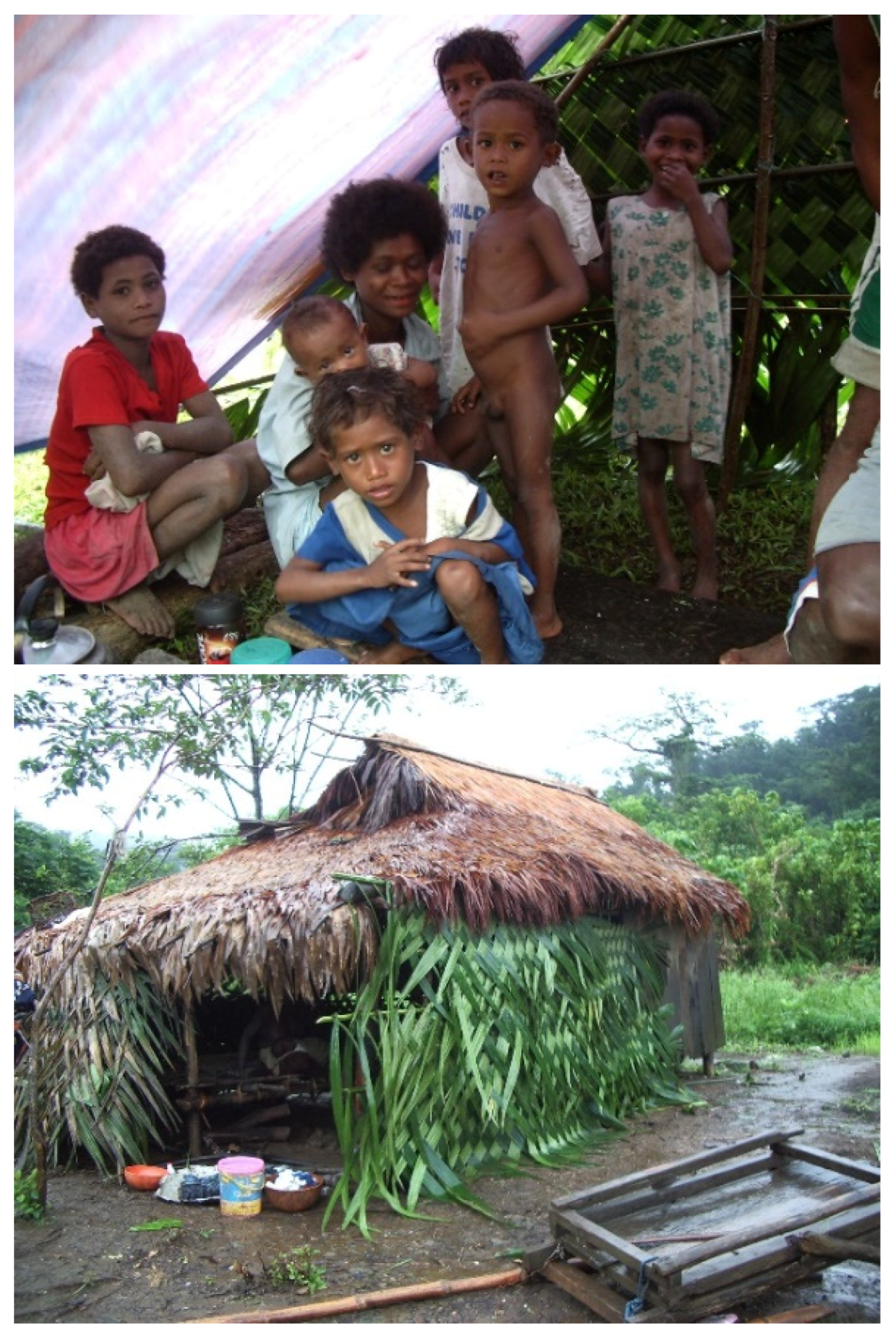
The Agta’s livelihood and mobility strategies have evolved to respond to these fluctuations and have different emphases in the wet and dry seasons. For instance, fishing in rivers and on reefs is primarily done during the hot, dry season, when waters are calm and clear. As spear fishing is the predominant technique used, visibility is crucial. This is also the season in which mobility is highest: several nuclear families may group together in temporary shelters on a beach or riverbed, from where they fish for a few consecutive days before returning to the more permanent hamlet or moving on to the next fishing site. The dry season also marks the peak in collection of most fruits and honey, which requires lengthy trips into the forest. During the wet season, mobility decreases and nuclear families come together in larger, more permanent settlements. Housing then ranges from open huts with a lifted bamboo floor and palm thatched-roofs, to two room houses with timber walling and corrugated iron roofs [48]. Fishing is hampered by rough seas and rivers, colder water temperatures, and poor visibility. Depending on the group’s location and individual preferences, hunting, swidden cultivation, and casual labor become more important (see Figure 3).
However, these strategies to navigate seasonal fluctuations are compromised by changing environmental conditions. Even in the remotest areas, the integrity of coastal and forest ecosystems has been undermined by the combined effects of deforestation, population pressure and resource depletion. Apart from the direct ecological impacts of logging and subsequent land conversion on tree cover and wildlife abundance, the influx of company laborers has meant additional pressure on fish and game. As a result, the Agta’s fishing and hunting success has dwindled up to the point that some Agta groups have given up on hunting [40], while fishing has become extremely unrewarding, especially in upriver ‘logging hotspots’ [45].
Unsustainable logging practices further undermine the forest’s important role in water regulation [49]. With heavily eroded riverbanks, blocked watercourses, and denuded hillsides, the forest is no longer able to absorb the amount of water that it used to. This results in flashfloods and mudslides both in upstream areas and in the densely populated downstream plains. This situation persists despite the designation of the Northern Sierra Madre Natural Park as a protected area in 1997. Due to weak environmental governance and law enforcement, overharvesting of timber and non-timber forest products has continued [50]. The recent and contested construction of a road across the protected area is expected to further aggravate this situation [42].
This reduced protective function of forests is arguably among the foremost concerns in relation to climate change for the Agta and for Northeastern Luzon as a whole. The main known impact of climate change to be seen in the region is a further increase of the already existing seasonal fluctuations. Specifically, an increase in rainfall during the wet season, and a decrease in rainfall during the dry season is expected, as well as an increase in the occurrence of natural hazards like typhoons, floods, and landslides [46,47]. Longitudinal data on tropical storms since the 1950s show, that there has already been an increase in the highest category typhoons [51].
Typhoons have always been part of life in Northeast Luzon and several observations can be made that hint at the Agta’s relatively favorable adaptations towards this harsh climate. This should however not be misunderstood to suggest their being ‘typhoon resilient’ under new conditions of climate change. Certainly, the earlier mentioned diversity of their livelihood package in itself serves as a way to spread risk, including the risks brought about by extreme weather. Also, while Agta minimally engage in agriculture, the few crops that they do grow are usually typhoon-resistant root crops such as sweet potato and cassava, rather than the vulnerable cash crops yellow corn and rice that dominate the region. Marginal as the Agta’s fields may seem, being spread out in multiple locations they do serve as an important source of ‘famine food’, while requiring minimal maintenance [40,52].
With respect to Agta’s strategies to seek protection during typhoons, little information is available to establish their effectiveness. We know that these strategies include digging shelters under big, previously fallen trees, hiding in caves, closing open huts with woven palm fronds, and constructing specific ‘typhoon houses’. These are built very low to the ground, in an open space away from rivers and coasts, and provide shelter for several nuclear families. Agta living closer to villages and towns sometimes seek safety in designated evacuation centers, like churches and schools [48].
Interestingly, as part of various post-typhoon relief aid programs, and especially following typhoon Juan in 2010 (international name ‘Megi’), local authorities have actively encouraged Agta in coastal areas to move land inward and build ‘permanent houses’ (i.e., houses with concrete hollow-block or timber walls and tin roofs). While a few individuals and families have responded positively, many are ambivalent towards these housing schemes. Some claim they never received the construction materials that were meant for them; others say they are not interested in them anyway because they prefer to continue living where and how they have always lived. Among their hesitations is the fact that the schemes result in houses that may be slightly sturdier than the Agta’s usual houses, but that they are certainly not typhoon-proof. This results in additional dangers from wild-flying tin roofs during typhoons as well as a lot of costly repair work afterwards [48].
Most importantly, these material interventions only serve to mitigate impacts without addressing the underlying problem. The highest numbers of deaths do not arise from the storm itself, but from floods, mudslides, and landslides that occur during and after the associated heavy downpours [53]. With forests being severely reduced in size and quality, their protective function has diminished [47]. Thus, the focus on technical aspects of typhoon mitigation distracts attention from the root-causes of the arising disasters: decades of unsustainable forest management.

3.2. The Orang Rimba of Jambi, Central Sumatra (Indonesia)

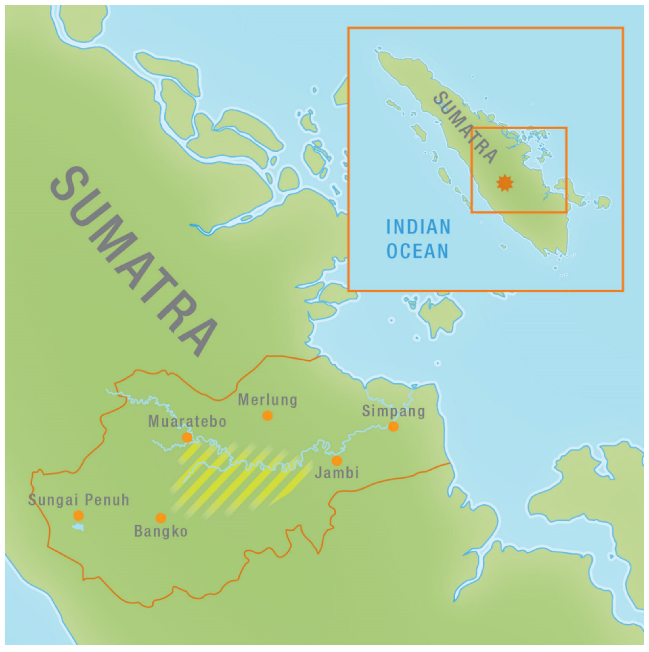
The Orang Rimba, formerly also known as the Kubu or the Anak Dalam, traditionally occupied the lowland forests of the central part of Sumatra. They were hunters and gatherers with only limited contacts with the outside world, which mainly consisted of the Malay people, who were living in scattered settlements along the banks of the major rivers. Since the early reports on the Orang Rimba, they have always been described as living in extremely poor conditions. Many Dutch colonial administrators as well as early ethnographers believed that they were on their way to either complete assimilation into the Malay society or they would go extinct in the near future. They made their living through hunting animals like monkeys, wild pigs, and deer and by collecting a variety of wild tubers and forest fruits. Through a system of ´silent trade´ they were exchanging some forest products like rattan and honey for tobacco, iron ware, and cloth [54,55]. They were living in small bands. Their huts consisted of lean-to´s or very small houses with a somewhat elevated floor. The Orang Rimba in general moved within a particular part of watershed of one of the major rivers in the area. On the basis of their intimate knowledge of such an area they could making a living from the available resources [56,57] (see Figure 4).
Since the beginning of the so-called New Order of President Suharto (1966–1997) large areas of the lowland forests were granted as concessions for logging companies. Sometimes the areas were designated as production forests but very often they were converted into plantations for crops like rubber and palm oil or they were planned as sites for the large scale transmigration of people from the overpopulated islands of Java, Bali, and Madura. In the area there were also mining activities. At the same time, the infrastructure in terms of roads was developed. The Trans Sumatra Highway, running from the north of the south of Sumatra was cutting through the forests and very soon a dense web of secondary and tertiary roads started to be developed [57].
Specifically for the Orang Rimba, just like for all other ‘isolated tribes´ the Indonesian government implemented a special development program. In so-called resettlement villages the scattered living people were housed in an effort to turn them over a number of years into modern Indonesian citizens. They had to give up hunting and gathering and become permanent agriculturalists. In addition, their children had to be sent to school and they had to embrace one of the officially accepted religions in Indonesia [57].
Though some of these resettlement villages were actually built, most of the Orang Rimba refused to live in them. They preferred the forest, even the remnants of the forest or the heavily logged over forest to living in such neat villages under daily supervision of government officials and ‘community workers’. They preferred to stay at a safe distance from the Malay people, who have always looked down on them as being primitive and dirty [58] (see Figure 5).
In the past few decades, the lowland forests of Central Sumatra have become one of the most severely degraded areas in the whole of Southeast Asia [59,60]. Large-scale logging followed by conversion into oil palm rubber plantations, or clear cutting the forests to make room for transmigration sites for people from the overpopulated islands of Java and Bali have reduced the amount of relatively intact forest to marginal areas compared to the original forest cover. A road network of highways and connecting roads to all major towns and settlements has provided relatively easy access to the forest resources, which is further supported by a dense web of logging roads and other secondary roads that connect the plantations to processing units for palm oil or rubber. These roads have provided ample opportunities for spontaneous migrants from various parts of Sumatra and other Indonesian islands in search of arable ‘empty’ land. From satellite images, it is clear how the road network facilitated this encroaching process. Only a relatively small portion of the area have been designated as national parks or reserves with a lower protection status [58].
The results of these processes for the Orang Rimba have been enormous. They could no longer make a living in the forests the way they had done in the past. One way or the other they had to adjust to the new circumstances. They did not avail of ways to resist these outside pressures. On the contrary: their reaction was usually one of retreat and avoidance. But with little forest left to retreat to, they had to adjust to the new conditions. They have done in various ways. Some have been able to survive in a more or less traditional way in some of the protected areas such as the national parks of Bukit Duabelas or Tiga Puluh. At the other end of the spectrum there are, what is being called ‘the highway nomads’, people who hang around in bus terminals along the major roads. They beg for some food or money or try to sell medicinal plants from the forest or wild honey. In between those extremes there are various kinds of adaptation. Some Orang Rimba make a living by so-called ‘garden hunting’, which takes place in the extensively used forest fields of the Malay people. The Orang Rimba hunt wild animals which the Malay people consider as pests for their agricultural crops (like bananas, cassava, and a variety of fruit trees). Animals like wild pigs, deer, and monkeys like to forage in those gardens because of the relative abundance of food. For that reason, the Malay villagers consider these animals as pests. By allowing the Orang Rimba to hunt in the forest fields, they reduce the loss of food crops for the Orang Malay while hunting itself is not as difficult as in the rain forest itself because of the higher density of animals. The Orang Rimba may also be hired by the Malay people to harvest the rubber or to do other types of paid work in their forest gardens. In this way a kind of symbiosis has developed between some Orang Rimba and the Malay people [57,61].
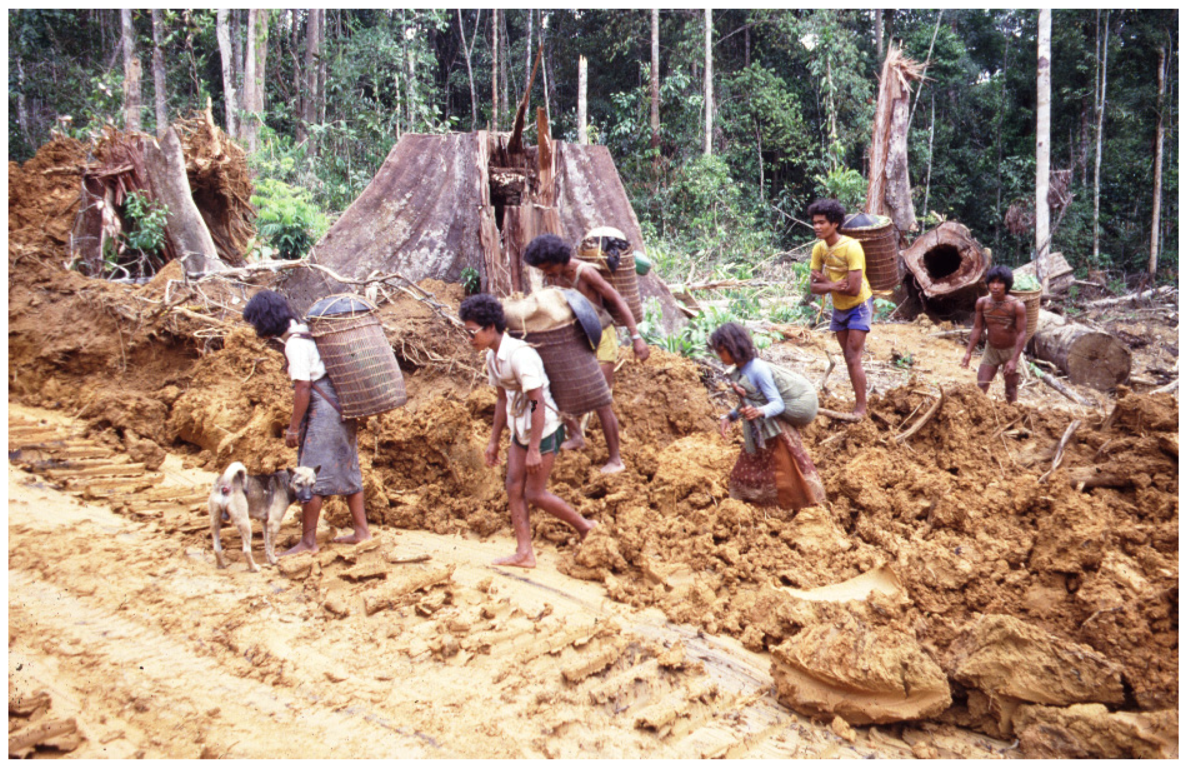
Other Orang Rimba have decided to pick up agriculture and they have started to plant rubber trees in small gardens in already logged-over forest. By producing latex, they avail of a cash crop that can yield money to buy rice, cigarettes, sugar, coffee, canned fish, and a range of other products. Some of them have done relatively well in recent years and they have succeeded in buying motor bikes and hand phones. But they continue to live in relatively simple huts or even lean-to’s at a safe social distance from the settlements of the Malay people. They may visit shops or weekly markets in the villages but their social contacts with the villagers remains limited [62].
But there are also less fortunate Orang Rimba, or people who have for one reason or the other have not been able to make the transition to become farmers themselves or who have not been able to enter into a kind of symbiotic relationship with Malay farmers. Some groups survive in the oil palm plantations by hunting wild pigs, which do surprisingly well in these plantations by foraging on the fallen fruits of the oil palm. Some Orang Rimba may also get small amounts of money or hand-outs in kind by the companies as a form of compensation for the loss of forest and all its resources.
In looking back at the old predictions about the Orang Rimba as being on their way to either extinction or complete assimilation, it is surprising to realize that they have been able to develop new strategies for survival. They have neither gone extinct nor have they completely assimilated into the Malay village communities or into the Javanese transmigration settlements. They have gradually developed a range of adaptation strategies based on their knowledge, skills, and preferences. In doing so they have continued to resist to enter into mainstream Indonesian village life with all its facilities in terms of education, health care, religion, and administration. Their preferred lifestyle has remained the same in the sense of staying at a safe distance from the Malay or Javanese communities in order to avoid social conflicts and discrimination on the basis of their ascribed characteristics. At the same time, they have been creative and innovative enough to make the best possible use of whatever opportunities became available with the arrival of logging companies, and the waves of migrants. They also realized in time that a transition from a hunting and gathering way of life to a more sedentary life based on the cultivation of cash crops like rubber was unavoidable. The range of modes of survival developed by the Orang Rimba is a clear example of the enormous amount of resilience that they have and that they have used in order to avoid the long predicted types of futures for them in terms of them going extinct or becoming the ‘victims of development’. There can be no doubt about the fact that the combined impact of all types of human interventions in the territory of the Orang Rimba is far greater than the impact of the change in annual rainfall or the small increase in temperature [58].

3.3. The Mentawaians of Siberut, West Sumatra (Indonesia)

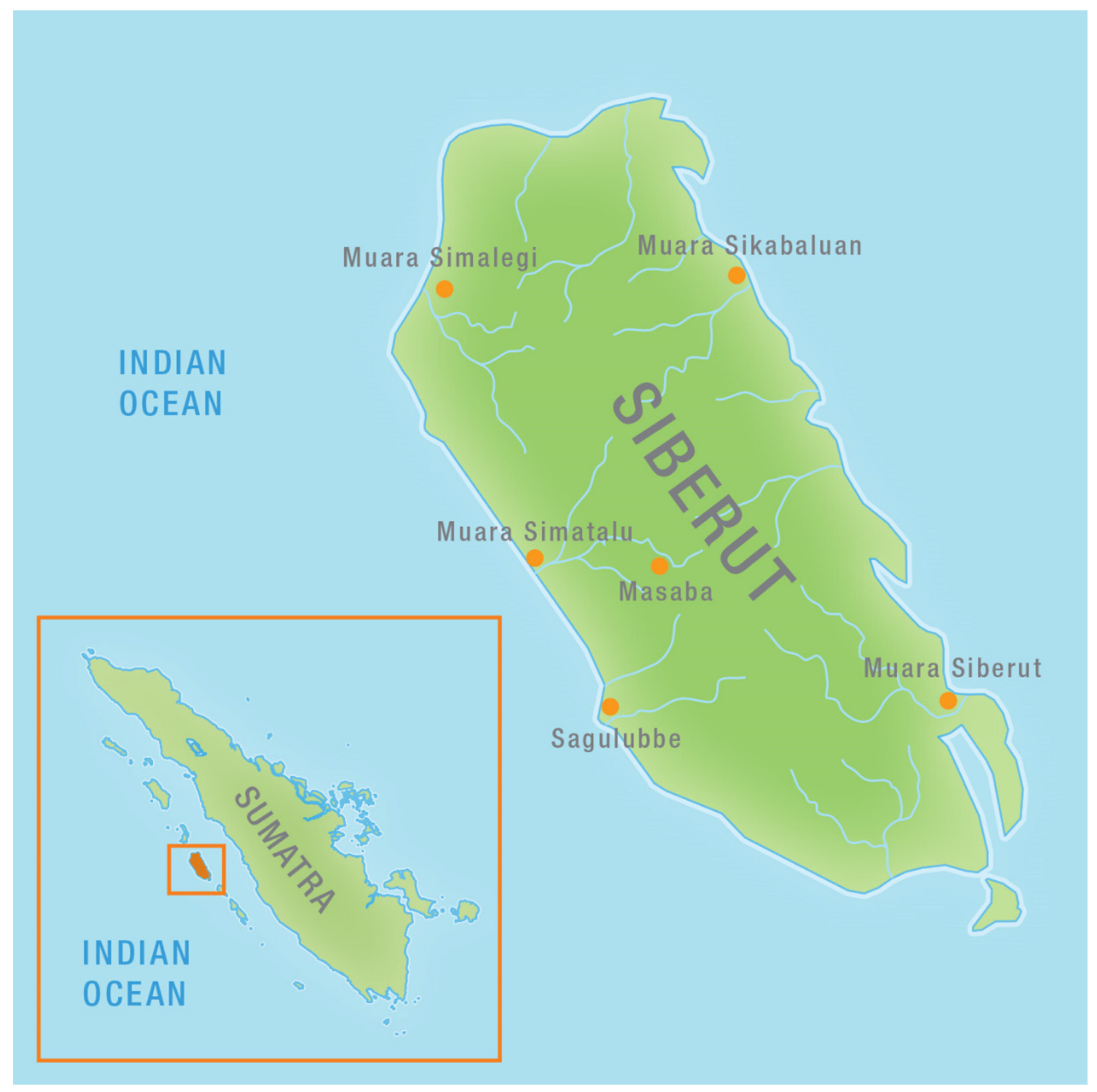
The Mentawai Archipelago is a chain of islands off the west coast of Sumatra. The four largest islands are inhabited by an indigenous group called the Mentawaians, and a small number of migrants. The archipelago has a total population of about 65,000 of which 35,000 live on the largest island Siberut. The people live in what used to be a dense tropical rainforest. Traditionally the autonomous patrilineal clans were living in small settlements along the banks of the main rivers that were flowing through the forest. Their houses, including the long house where all communal activities were taken place, were solid constructions made of locally available material. In addition to agricultural activities, they also hunted wild animals (in particular wild pigs, monkeys, and deer) and they domesticated pigs and chickens around their houses and field huts. Fishing took place along the coast and in the rivers and small lakes. Sago starch extracted from the sago palm (Metroxilon sagu) was the staple food. As a result of the abundant natural resources and the knowledge and skills of the local people developed over generations to make wise use of the resources, occasional visitors to the islands were always impressed by the material wealth, the elaborate rituals, and the physical fitness of the people, based on a large variety of types of food (see Figure 6).
Their complex religious system, known as sabulungan, including extensive taboo periods, was based on a belief in spirits in all living plants, animals, and the natural forces. The division of labor was limited to that between men and women. Every man and woman was supposed to acquire, avail and apply all skills and knowledge necessary throughout their life. The medicine man was the only exception. He was the one to restore harmony between humans and the spirit of the environment in case disturbances had occurred. He also availed of extensive knowledge of medicinal plants. To a large extent the people were economically self-sufficient. Limited exchange with Minangkabau traders of copra and rattan for tobacco, iron wear, and a number of other products had taken place for a long period [63].
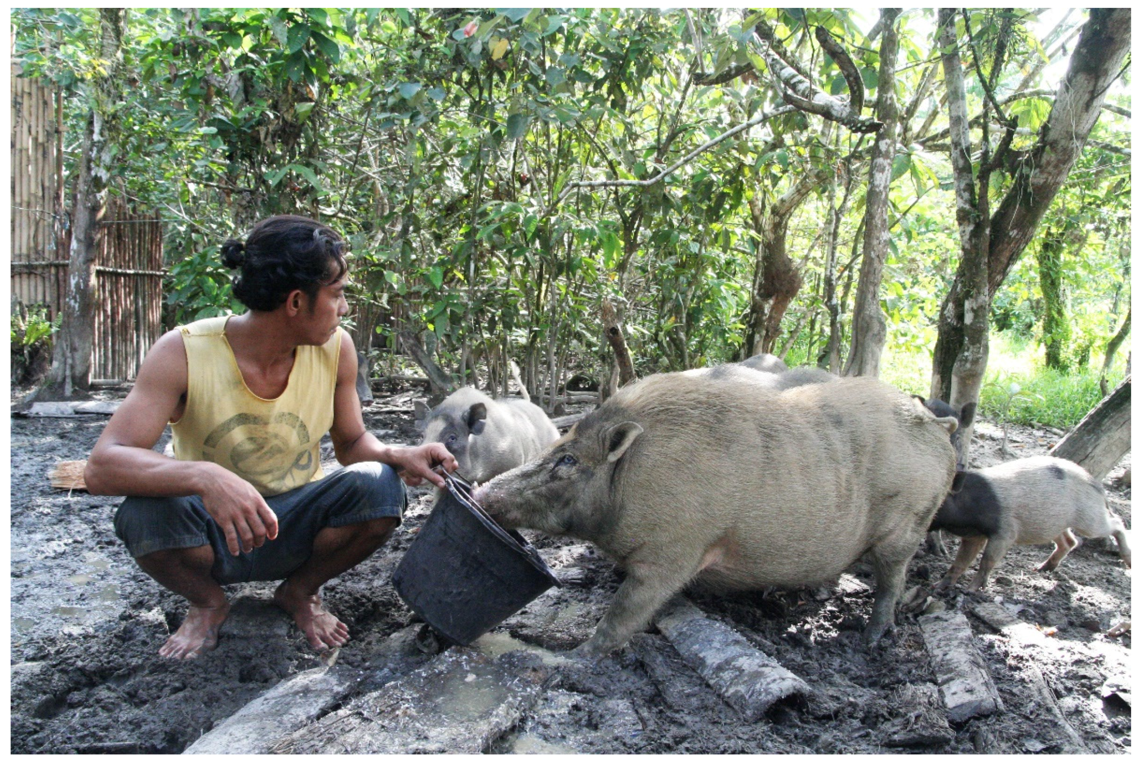
According to the Indonesian government, and earlier already to the Dutch colonial administration, the Mentawaians were thought to be rather primitive pagan people. In waves of governmental interventions, the local people were ordered to settle in larger villages, give up their traditional religion, and change their food habits. Instead of eating sago, considered a ‘lazy man’s food’, rice cultivation was strongly promoted. Also, the domestication of pigs around the settlement was condemned as a ‘bad tradition’ to be replaced by modern animal husbandry focused on goats, cows, and water buffalos. The traditional religion, considered ‘an excuse for extreme laziness’, was to be replaced by one of the officially recognized monotheistic religions in Indonesia. In short, and just like many other indigenous groups in Indonesia, the Mentawaians had to become socially, culturally, and economically like all mainstream Indonesians [57,64].
In the 1970s and 1980s, large logging concessions were granted to companies. Since the late 1970s various initiatives were undertaken to protect the natural environment as well as the traditional lifestyle of the local population. In 1981, Siberut was declared a Man-and-Biosphere Reserve by UNESCO, and WWF and Survival International were working together to promote the traditional and sustainable lifestyle, claimed to be in harmony with nature [65]. In the early 1990s about half of the island of Siberut was declared a national park (192,000 ha) and all logging concessions were cancelled. Since the late 1980s, Siberut started to attract numerous western tourists attracted by the image of a colorful ‘Stone Age Culture, living in harmony with nature’. Quite a few coffee table books, documentary films, and an entertainment television program based on living among the ‘jungle people’ promoting this image made the island a popular destination for these kinds of tourists [66].
So in fact there were two contradictory tendencies. On the one hand, the Indonesian government wanted to ‘civilize and develop’ the local people and turn them into modern Indonesians, while at the same time, tourists came to enjoy and have a firsthand experience of community living according to old traditions with extensive rituals. Because some areas were frequently visited by tourists while others were not, the difference between the two types of orientation also became stronger over the years. Welcoming visitors in one’s impressive longhouse in the forest, looking ‘traditional’, and performing colorful rituals paid off in terms of groups of tourists who were willing to pay well for such an experience, while Mentawaians in a dull resettlement village doing their daily agricultural and social activities, but without the elaborate and colorful rituals, did not attract such visitors. But the attitude towards ‘tradition’ or ‘modernity’ is not only determined by the attention of outsiders. A relatively large group of Mentawaians have, after years of being confronted with development and cultural policies, decided that the best way forward is to get involved in new economic opportunities, to allow children to enjoy higher education, and to forget about the traditional pig keeping and living in the traditional longhouse (see Figure 7). In order to do so they need new knowledge and skills to cope with the new challenges of generating a steady cash income.
Since 1999, shortly after the fall of President Suharto, the Mentawai Archipelago became an autonomous district as one of the first areas to enjoy regional autonomy which would spread all over the country. Ethnic Mentawaians can now be elected as districts officials and the Minangkabau no longer dominate local politics. Though the main orientation of the present district officials is without doubt towards modernization and economic development, at the same time there is also a tendency to hang on to certain symbols of the traditional culture as a kind of identity marker. So a huge part of the budget is being spent on the construction of roads, bridges, and harbor infrastructure to improve trade and transport possibilities. The head of the district has also agreed to a major investment plan for an international resort with an airport, luxury hotels, and all kinds of other facilities in the southern part of Siberut. But at the same time, he is also supporting a yearly festival for Mentawaian music and art forms, which may move into a kind of ‘folklorization’ of traditional culture [64].
Just like in other areas in Indonesia, the Mentawaian Islands are also experiencing climate change in terms of extended periods of drought and more excessive rainfall, even though specific information on this is not available. In general, these changes do not generate major problems for the local people. The structure of the island’s vegetation and hydrology, the characteristics of the soil in combination with the variety of livelihood practices (hunting, fishing, agricultural, and animal husbandry) have always prevented problems in terms of food or water scarcity. The lowland rainforest with extensive swamps did not completely dry out. People did not experience failures of crops simply because of the fact that they do not depend on rice cultivation or other annual crops. Sago palms and fruit trees survive even if rainfall is limited during certain periods. Floods do occur but with elevated houses on poles on the river banks and with agricultural crops that can easily withstand excessive water for shorter periods of time, this has never caused major problems. The same also counts for their domestic animals. As they are freely roaming around, the semi-domesticated pigs and chickens will find a safe place during floods and even in the dry periods, they are always able to drink in the rivers that never run dry. In that context, there was traditionally already a strong resilience to cope with the variability of the climatic and weather conditions on the islands.
More than climatic change however, the islands are facing serious hazards from another source, that is earthquakes and tsunamis. Because of its geographical location, the area is prone to frequent earthquakes and dangerous tidal waves. After the massive earthquake of 26 December 2004 near Aceh (North Sumatra), followed by the destructive tsunami that killed about 240,000 people in Indonesia alone, the Mentawaian Islands have experienced many more earthquakes in recent years. Several big earthquakes with or without tsunamis occurred along the Sunda megathrust and the great Sumatran fault in 2006, 2007, 2009, and 2010. As a result, some people have given up their dwellings along the coast and moved inland towards the hills. Others have built emergency houses in case such events will happen again [11,67]. Various initiatives have been taken to install early warning systems on the islands and evacuation plans in case the islands are being hit again by such hazards. Geologists predict that, sometimes in the future (but nobody can tell when this is going to happen), the islands may sink because the tectonic Indo-Australian Plate on which they are located, is slowly subsiding underneath the Sunda plate. On a small scale, the phenomenon is already visible: the small islands on the east side of Siberut are slowly subsiding while coastal erosion forces people to move their houses further inland. Though people have collective memories about these dramatic events and in the oral tradition interpretations are being mentioned, they do not offer sufficient options to cope with them, let alone face ‘the great earthquake’ as predicted by geologists. Compared to the knowledge and skills needed to face present-day impact of climate change, these events are of a radically different scale and potential impact [11].

3.4. The Ngaju Dayak of Central Kalimantan (Indonesia)

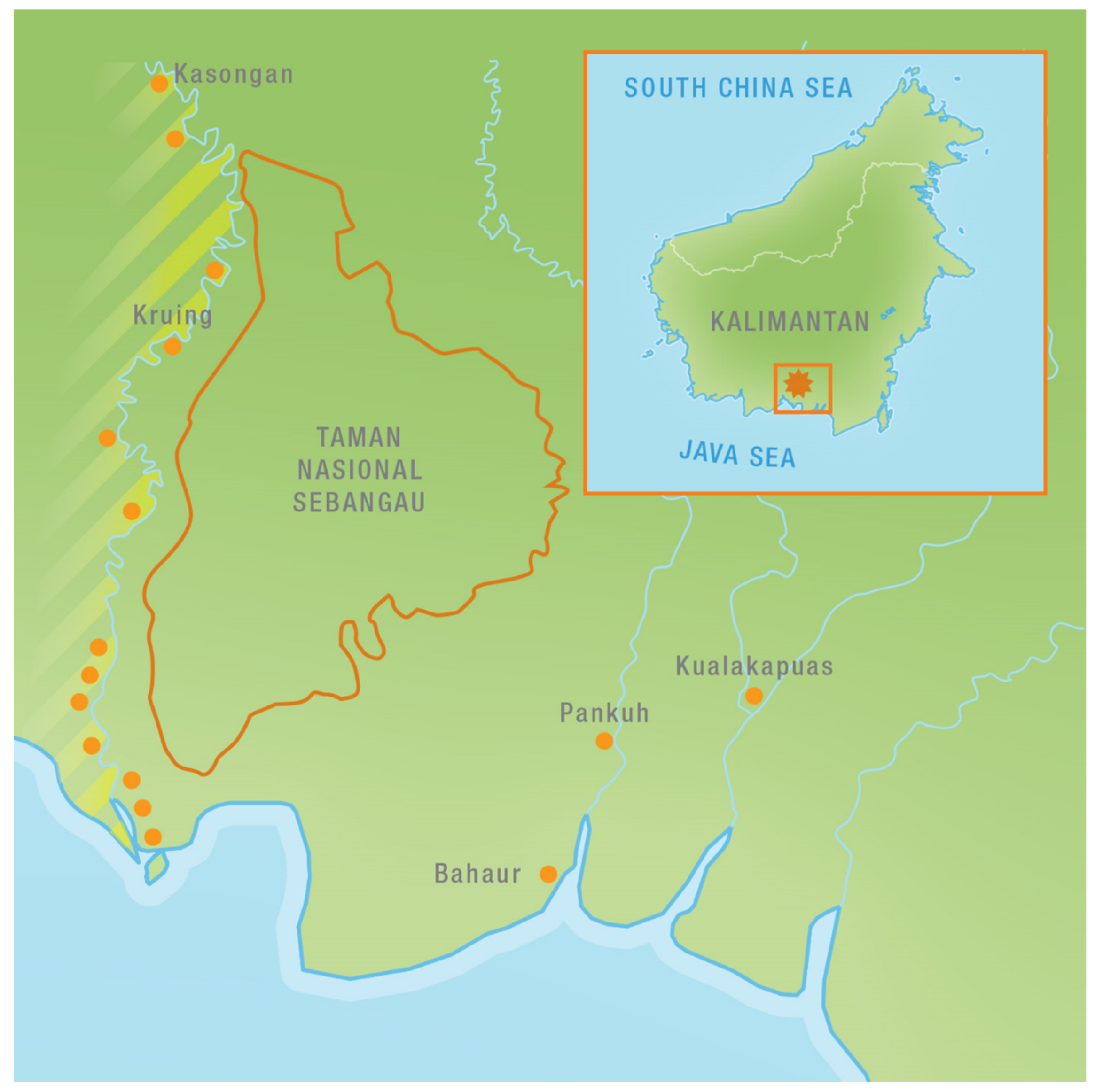
The Ngaju Dayak are one of the numerous indigenous Dayak tribes in Borneo with a total population of over one million. In addition to the Dayak, there are also other ethnic groups living in the Indonesian part of Borneo, such as the Banjarese in the southeastern part of the island or the Malay and Chinese, mainly living in the coastal towns and villages. In addition, there are also migrants from other Indonesian islands such as the Buginese from Sulawesi, or people from Java, Bali, and Madura who have come in the context of the official transmigration program. The Ngaju Dayak occupy a major part of the Indonesian province of Central Kalimantan. One of the sub-tribes is formed by the Katingan Ngaju Dayak named after the Katingan river running from the center of the heart of Borneo to the mouth of the river in the south, The Ngaju Dayak occupy in particular the low-lying peat swamp forests south of the provincial capital of Palangka Raya (see Figure 8).
They live in small villages on the elevated banks along the two main rivers in the area: the Katingan River and the Sebangau River. In between the two rivers, there is an extensive peat swamp forest which is home to a large population of orang utan, and numerous other species of animals. The Ngaju Dayak adhere a religion that is called kaharingan with a strong belief in spirits in the environment. Ancestor worship is also crucial. The elaborate rituals related to the second burial of family members (called tiwah) and the erection of wooden statues around the little house in which the bones are kept, are crucial elements in the culture and identity of the Ngaju Dayak [68,69].
Traditionally the main sources of livelihood for the Ngaju Dayak have been fishing, rice cultivation, and the collection of non-timber forest products of which various species of rattan, gemor (bark from a specific tree–Alseodahne sp.-which is used to produce anti-mosquito coils and glue), and jelutung (latex from a tree species called Dyera costulata, that is used for making chewing gum, paint, and priming cement) are by far the most important ones [70].
In the dry season, the people prepare their rice fields by cutting trees in the peat swamp forest and burning them once they are sufficiently dry. After burning the withered vegetation, rice seeds are placed in small holes made with a planting stick in between the stems and branches that are left after the fire. They do so by calling in the help of their family and friends. In the past, they have also planted rubber trees but because of falling prices and problems with selling the latex, these rubber gardens have not been well maintained. However, these old rubber trees are extremely useful for the rattan to climb to the canopy. Initially people were also planting rattan seedlings but nowadays the density of rattan plants and the amounts of seeds produced are so abundant that planting seedlings is no longer necessary. Numerous seedlings are to be found on the forest floor. Because of the long and sharp thorns harvesting of rattan is quite a tough job, done by men as well as women.
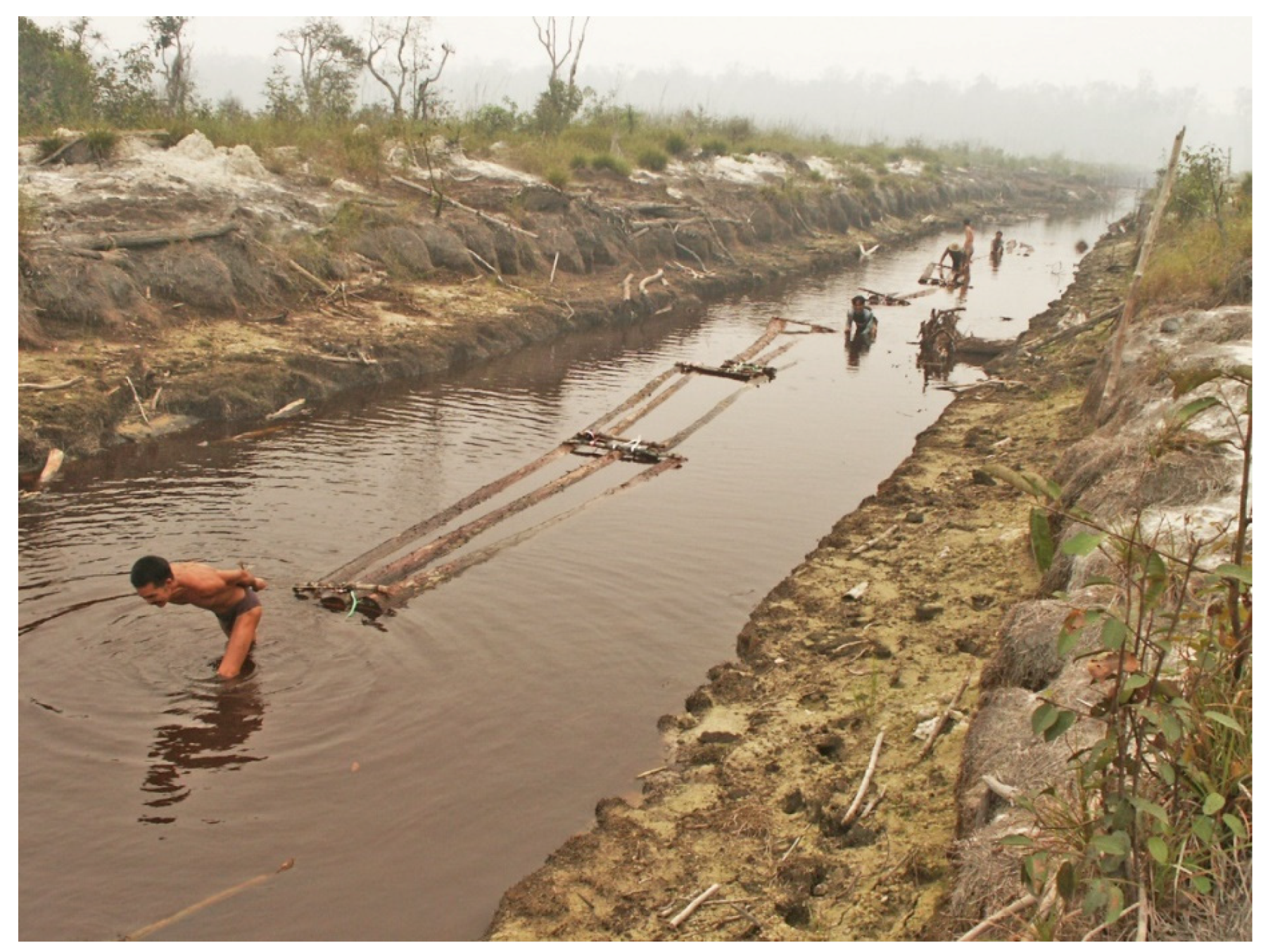
The Sebangau peat swamp forest is adjacent to an area that was targeted to become a very large area for rice cultivation. The so-called 1 million hectare Mega Rice Project (MRP) of former president Habibi, who became president of Indonesia when Suharto was forced to step down in 1998. The MRP aimed to turn the extensive peat swamp into a giant rice field to feed the ever growing Indonesian population. The project was initiated in 1995 in spite of the warnings sent out by numerous parties that predicted that the MRP would adversely impact the natural and socio-cultural environment [71]. After cutting the forest, large drainage canals were dug to get rid of the surplus water from the swamp. Some timber species also had commercial value and thousands of logs were sold on the international market. The massive forest fires of 1997/98 that occurred in Indonesia however also struck this mega-rice project, before any rice seedling was planted. The drained and dried out deep peat soil started to burn on a large scale. These fires would last for months, as peat fires are extremely difficult to extinguish. But in the middle of this environmental disaster, the heavy equipment was moved into the Sebangau area, and it was used to start digging canals that could be used for pulling out the logs of valuable tree species. A few hundred small saw mills were constructed along the Katingan and Sebangau rivers. Thousands of logs were sawn into beams and planks to be sold in the international timber market.
Though the initial activities were started by former migrant workers from the Mega Rice Project, soon local people, and in particular the young men from the Sebangau area, joined the logging activities in an effort to profit from this new opportunity to earn substantial amounts of money, and to do so within a short time [70,72] (see Figure 9).
It did not take long however before these activities started to draw the attention from some policy makers, environmental scientists and conservation agencies. In addition to the yearly outbreak of massive peat swamp fires, which also cause serious health problems for the human population, the combination of the draining of the swamps, the logging activities and the fires, also caused large problems to the wildlife in the area. In particular the iconic animal of the area, the orang utan, was threatened. Hundreds of orang utan were killed in the fires, just like many other animals. In a surprisingly short period plans were made to turn Sebangau into a protected area with the support of local authorities, the provincial university and WWF. During the Conference of the Parties (COP) of the Convention on Biological Diversity (CBD) of 2004, held in Kuala Lumpur, Indonesia announced the Sebangau area as a national park with an area of more than 600,000 ha. To make this work as a conservation area, one of the first things that needed to be done was to stop all logging activities and to close the canals to avoid the further draining of the peat swamps. In addition, all saw mills had to be closed and dismantled too. In theory this was easier said than done of course, as many people had invested substantial amounts of money and energy in the digging of the canals, the setting up of the saw mills, and in attracting a substantial work force. Also, many local people had found employment in the logging sector. They were not willing to give up their source of income easily.
After a difficult and pretty rough time, the park management with the support of WWF, succeeded in fighting the logging activities, which had been illegal from the beginning but which were never actually stopped. Most of the larger canals were closed by the construction of dams, thereby reducing the further drainage of the swamp and subsequently also avoiding the drying out of the peat soil. For the local people alternative sources of livelihoods were being developed in the field of the processing of non-timber forest products, agriculture, fisheries, and eco-tourism. However, though these alternatives were well intended, they could never completely replace the income generated by the logging activities [72]. Many of the young and able men started to look for other income generating activities outside the Sebangau area. Most of them found employment in the palm oil plantations or left for the major towns in the province. Only few them returned home to pick up fishing, rice farming, or collecting NTFPs again.
This part of Kalimantan, like the rest of Borneo, has experienced various aspects of climate change. In particular the extended El Niño periods have had their impact. But the impact of the drought periods has very much been aggravated by human activities through the draining of the swamps and the logging activities. Large areas have been deforested, the peat swamp forests have been drained, by which they became susceptible to peat land fires. Biodiversity and wildlife have been reduced and threatened. Populations of some animals, in particular the larger mammals, have been reduced dramatically. The conservation status of Sebangau as a national park has to some extent limited the possibilities of expanding rice fields, or the collection of non-timber forest products from within the park. This is also one of the conditions under which funding for the area has become available under the so-called REDD+ scheme. Among others, the government of Norway has made money available for the protection of the park on condition that the area is well protected and no further degradation takes place. Along the boundaries of the park, the options for local resource use are still available, but for the younger generation these options are no longer attractive and they no longer suffice. The intermediate period with the extensive logging activities and the flow of money and goods has changed their aspirations and just like in so many other areas, they move away from their home areas and the traditions that have long determined the local life style.

4. Discussion

There is ample evidence from the examples given above that indigenous peoples in Southeast Asia, as those in other regions, have been able to survive in their home environment on the basis of the extensive knowledge about the available resources and the practical skills to turn them into food or other useful products. This extensive knowledge about animals and plants, their characteristics, and the ecosystems in which they live, has grown over generations and it has been transmitted to the next generation by explicit knowledge transfer, by imitation, and by other means of learning such as storytelling. Time and time again, this knowledge has been recognized by researchers from diverse disciplinary backgrounds [10]. The indigenous peoples have also incorporated new experiences for instance after experiencing irregular natural and environmental hazards like heavy storms, excessive flooding, or earthquakes. They have learned to avoid risks related to such events [40]. They have adjusted their modes of food production, their house construction, and in some cases also the very location of their settlement. They have also been able to make use of the wide range of natural resources to survive during periods of hardship. There were always emergency types of food available or they could rely on extensive exchange relations with neighboring groups. Mobility or being able to move to other places in times of trouble has also been a strategy to avoid or mitigate serious problems. Over time, they have benefitted from interaction with outsiders and they have incorporated new knowledge and practical skills, including useful tools obtained through this interaction, in their enriched indigenous knowledge systems [73,74].
Most of the indigenous peoples have been faced with interventions of outsiders in their search for timber or valuable minerals. Governmental policies were usually aimed at bringing the nomadic or scattered population together into larger resettlement villages, where development programs could be implemented. Sedentarization and permanent agriculture were to replace the mobile lifestyle based on hunting and gathering, often in combination with particular forms of shifting agriculture. Such programs of ‘imposed development’ have only had limited success, particularly in the initial phases of their implementation. Explicit resistance to such programs has been rather minimal. Most of the groups simply do not avail of sufficient numbers of people or levels of social organization to openly oppose such programs, even though they may profoundly disagree with their aims. They may also be intimidated by the government officials and implementing agencies to speak out against these plans. They have to fight with what J. Scott [75] labeled as the ‘weapons of the weak’, that is civil disobedience, retreat, and other less obvious forms of non-compliance.
But over the years, the combination of the environmental changes brought about by the encroachment of the logging and mining companies, the increased interaction with various groups of outsiders, and the implementation of the programs of imposed development, has changed and limited indigenous peoples’ options. Silent retreat is no longer a solution and in many cases adjustment to the new circumstances is unavoidable. In particular, the younger generation is gradually losing its interest in the traditional way of life of their parents and grandparents. Usually the young men are the first to have increased interaction with the outside world and they become familiar with the attractions of the modern and urban world. Acquiring new knowledge and skills is necessary to have success. They lose their interest in traditional knowledge and skills, which they no longer consider necessary for their future. Slowly they become estranged from their home community and some of them may leave their village in search of paid jobs elsewhere. Depending on the wider social context, some may keep a selective interest in their ethnic identity and some traditions.
One of the aspects of the increased interaction with the outside world is related to the transmission of information. In countries like the Philippines and Indonesia, climate change has become a dominant theme in the discourse about causes of natural hazards, environmental changes, and phenomena like flooding and coastal erosion. Very often ‘climate change’ is put forward as an explanation for particular events or conditions [12,13]. But what aspect of climate change in particular is held responsible for such events and to what degree is less obvious. The scale and duration of forest fires in the peat lands for instance cannot be attributed only to the extended dry periods. Without large scale logging and draining of the peat swamp forests, the fires could not have occurred at the same scale and intensity as they have done in recent years. In an interesting report about impact of climate change, issued by the US National Intelligence Council, the overall conclusion for the region was very clear: ‘Southeast Asia faces a greater threat from existing manmade environmental challenges than from climate change to 2030.’ [20].

5. Conclusions

Blaming ‘climate change’, which is an abstract notion without easily identifiable actors, often is a politically more convenient and less dangerous strategy than looking more closely at the impacts of specific forms of unsustainable resource use and the people or official agencies who are responsible for them. Through the public campaigns to increase awareness about climate change, the wide media attention for this topic, and the attention that many NGOs are paying to it, climate change has become an often used theme in the discourse and rhetoric about environmental changes that is nowadays also often used by indigenous peoples in the context of Southeast Asia [12].
However, as we have seen above, the way climate change manifests itself is not the same across the region. Some areas experience less rainfall, while other areas experience more rainfall. Variation in temperature also varies. Also on top of that, in some cases, as we have seen in the case of Mentawai, geological phenomena like subsidence, or in other cases earthquakes or tsunamis, have equally had a large impact on the environmental conditions in which these indigenous peoples have survived so far and that they intend to continue to live in for the future.
Most importantly, based on our experiences among these communities, we argue that the main causes of current and past environmental change and its serious impacts on livelihoods and wellbeing, should be attributed to the processes of deforestation and land conversion that we have described in the case studies. Interventions that will address these pressing issues will go a long way in making forest-dwelling indigenous communities more resilient towards present and future impacts of climate change. An awareness and appreciation of the wealth of their ecological knowledge, while including their practical skills, can be of great value in the design and the implementation of such interventions.

Author Contributions

Conceptualization G.A.P. and T.M., methodology, G.A.P. and T.M., formal analysis, G.A.P. and T.M., resources, G.A.P. and T.M., writing G.A.P. and T.M., visualization, G.A.P. and T.M. Both authors have read and agreed to the published version of the manuscript.

Funding

The research on which this article is based was funded by various research projects mainly through Leiden University. In addition, research activities took place within the context of a number of conservation and development projects. These include The Siberut Project of Survival International and the Junior Expert Program (JEP) both funded by the Dutch Ministry of Foreign Affairs, the Indonesia Biodiversity Project funded by the Asian Development Bank, the Sebangau Project funded by WWF Netherlands, and the Indigenous Participation in Protected Area Management Project funded by the Netherlands Committee of Indigenous Peoples (NCIV).

Acknowledgments

This paper is based on fieldwork by both authors in various periods and in the context of a number of research or conservation projects, mainly through Leiden University. The authors would like to thank three of their students, all financed by the Louwes Fund for Research on Water and Food through Leiden University, who have conducted fieldwork among the communities mentioned. Mayo Buenafe–Ze has worked among the Agta in the Philippines, Wardani Ekoningtyas did fieldwork among the Orang Rimba, while Darmanto studied the Mentawaians of Siberut.

Conflicts of Interest

The authors declare no conflict of interest. The funders had no role in the design of the study; in the collection, analyses, or interpretation of data; in the writing of the manuscript, or in the decision to publish the results.

References

  1. Barnes, R.H.; Gray, A.; Kingsbury, B. (Eds.) Indigenous Peoples of Asia; The Association for Asian Studies Inc.: Ann Arbor, MI, USA, 1996. [Google Scholar]
  2. Erni, C. (Ed.) The Concept of Indigenous Peoples in Asia. A Resource Book; IWGIA: Copenhagen, Denmark, 2008. [Google Scholar]
  3. Cairns, M. (Ed.) Shifting Cultivation and Environmental Change. Indigenous People, Agriculture and Forest Conservation; Routledge: London, UK; Earthscan: London, UK, 2015. [Google Scholar]
  4. Endicott, K. Introduction: Southeast Asia. In The Cambridge Encyclopedia of Hunters and Gatherers; Lee, R.B., Daly, R., Eds.; Cambridge University Press: Cambridge, UK, 1999; pp. 275–283. [Google Scholar]
  5. van der Ploeg, J.; Persoon, G.A. Figments of Fire and Forest. Shifting Cultivation Policy in Indonesia and the Philippines. In Shifting Cultivation Policies. Balancing Environmental and Social Sustainability; Cairns, M., Ed.; CABI: Wallingford, UK, 2017; pp. 3–26. [Google Scholar]
  6. Cairns, M. (Ed.) Shifting Cultivation Policies. Balancing Environmental and Social Sustainability; CABI: Wallingford, UK, 2017. [Google Scholar]
  7. Conklin, H.C. Hanunóo Agriculture. A Report on an Integral System of Shifting Cultivation in the Philippines; FAO: Rome, Italy, 1957. [Google Scholar]
  8. Bahuchet, S.; Grenaud, F.; Grenaud, P.; de Maret, P. Tropical Forests, Human Forests. An Overview; Programme Avenir des Peuples des Forêts Tropicales: Brussels, Belgium, 2001. [Google Scholar]
  9. Barden, A.; Awang Anak, N.; Mulliken, T.; Song, M. Heart of the Matter. Agarwood Use and Trade and CITES implementation for Aquilaria Malaccensis; TRAFFIC: Bangkok, Thailand, 2010. [Google Scholar]
  10. Posey, D. (Ed.) Cultural and Spiritual Values of Biodiversity. A Complimentary Contribution to the Global Biodiversity Assessment; Intermediate Technology Publications: London, UK, 1999. [Google Scholar]
  11. Tulius, J. Lesson from the past, knowledge for the future: Roles of human memories in earthquake and tsunami narratives in Mentawai, Indonesia. Paradig. J. Kaji. Budaya 2020, 10, 147–168. [Google Scholar] [CrossRef]
  12. Tamayo, A.L.; Alangui, W. (Eds.) Knowledge, Innovation and Resilience. Indigenous Peoples’ Climate Change Adaptation and Mitigation Measures; Tebtebba: Baguio, Philippines, 2012. [Google Scholar]
  13. Nakashima, D.J.; GallowayMcLean, K.; Thulstrup, H.D.; Ramos Castillo, A.; Rubis, J.T. Weathering Uncertainty: Traditional Knowledge for Climate Change Assessment and Adaptation; UNESCO and Darwin, UNU: Paris, France, 2012. [Google Scholar]
  14. Savo, V.; Lepofsky, D.; Benner, J.P.; Kohfeld, K.E.; Bailey, J.; Lertzman, K. Observations of climate change among subsistence-oriented communities around the world. Nat. Clim. Change 2016, 6, 462. [Google Scholar] [CrossRef]
  15. IPCC Climate Change 2014: Synthesis Report. Contribution of Working Groups I, II and III to the Fifth Assessment Report of the Intergovernmental Panel on Climate Change; IPCC: Geneva, Switzerland, 2014.
  16. Bohensky, E.L.; Kirono, D.; Butler, J.; Rochester, W.; Habibi, P.; Handayani, T.; Yanuartati, Y. Climate knowledge cultures: Stakeholder perspectives on change and adaptation in Nusa Tenggara Barat, Indonesia. Clim. Risk Manag. 2016, 12, 17–31. [Google Scholar] [CrossRef] [Green Version]
  17. Djalante, R. Review article: A systematic literature review of research trends and authorships on natural hazards, disasters, risk reduction and climate change in Indonesia. Nat. Hazards Earth Syst. Sci. 2018, 18, 1785–1810. [Google Scholar] [CrossRef] [Green Version]
  18. Leng, L.Y.; Ahmed, O.H.; Jalloh, M.B. Brief review on climate change and tropical peatlands. Geosci. Front. 2019, 10, 373–380. [Google Scholar] [CrossRef]
  19. Ministry of Environment. Climate Change in Southeast Asia; Output from GCM; Global Environment Bureau: Tokyo, Japan, 2018. (In Japan) [Google Scholar]
  20. NIC (National Intelligence Council). Southeast Asia: The Impact of Climate Change to 2030. Geopolitical Implications; NIC: Washington, DC, USA, 2010.
  21. Carter, S.; Manceur, A.M.; Seppelt, R.; Hermans-Neumann, K.; Herold, M.; Verchot, L. Large scale land acquisitions and REDD+: A synthesis of conflicts and opportunities. Environ. Res. Lett. 2017, 12, 035010. [Google Scholar] [CrossRef]
  22. Alangui, W.V.; Subido, G.; Tinda-an, R. (Eds.) Indigenous Peoples, Forests and REDD Plus. Sustaining and Enhancing Forests through Traditional Resource Management; Tebtebba: Baguio, Philippines, 2010; Volume I. [Google Scholar]
  23. de Chavez, R. (Ed.) Indigenous Peoples, Forests and REDD Plus. Sustaining and Enhancing Forests through Traditional Resource Management; Tebtebba: Baguio, Philippines, 2013; Volume II. [Google Scholar]
  24. Sarmiento, J.P.; Larson, A.M. Rights Abuse Allegations in the Context of REDD + Readiness and Implementation. A preliminary Review and Proposal for Moving Forward; CIFOR Infobrief no. 190; CIFOR: Bogor, Indonesia, 2017. [Google Scholar]
  25. Fox, J.; Castella, J.C.; Ziegler, A.D. Swidden, rubber and carbon: Can REDD+ work for people and the environment in Montane Mainland Southeast Asia? Glob. Environ. Change 2014, 29, 318–326. [Google Scholar] [CrossRef] [Green Version]
  26. Sponsel, L.E.; Headland, T.; Bailey, R. (Eds.) Tropical Deforestation. The Human Dimension; Columbia University Press: New York, NY, USA, 1996. [Google Scholar]
  27. Boomgaard, P.; Henley, D.; Osseweijer, M. (Eds.) Muddied Water. Historical and Contemporary Perspectives on Management of Forests and Fisheries in Island Southeast Asia; KITLV Press: Leiden, The Netherlands, 2005. [Google Scholar]
  28. FAO; UNEP. The State of the World’s Forests. Forest, Biodiversity and People; FAO: Rome, Italy, 2020. [Google Scholar]
  29. MacKinnon, K.; Hatta, G.; Halim, H.; Mangalik, A. The Ecology of Kalimantan; The Ecology of Indonesia Series; Peripus Editions: Singapore, 1996; Volume III. [Google Scholar]
  30. van den Top, G.M. The Social Dynamics of Deforestation in the Philippines: Actions, Options and Motivations; NIAS Press: Copenhagen, Denmark, 2003. [Google Scholar]
  31. Lamichhane, B.R. Living with the Large Carnivores. The Interaction between Humans, Tigers and Leopards in Chitwan National Park, Nepal. Ph.D. Thesis, Leiden University, Leiden, The Netherlands, 2019. [Google Scholar]
  32. Headland, T.N. Thirty Endangered Languages in the Philippines; Work Papers of the Summer Institute of Linguistics, University of North Dakota Session; SIL International: Dallas, TX, USA, 2003; Volume 47, Available online: http://www.und.edu/dept/linguistics/wp/2003Headland.PDF (accessed on 23 August 2003).
  33. Mijares, A.S.; Détroit, F.; Piper, P.; Grün, R.; Bellwood, P.; Aubert, M.; Champion, G.; Cuevas, N.; de Leon, A.; Dizon, E. New evidence for a 67,000-year-old human presence at Callao Cave, Luzon, Philippines. J. Hum. Evol. 2010, 59, 123–132. [Google Scholar] [CrossRef] [PubMed]
  34. Bellwood, P. First Farmers: The Origins of Agricultural Societies; Blackwell Publishing: Oxford, UK, 2005. [Google Scholar]
  35. Headland, T.N.; Reid, L.A. Hunter-gatherers and their neighbours from prehistory to the present. Curr. Anthropol. 1989, 30, 43–66. [Google Scholar] [CrossRef] [Green Version]
  36. Headland, T.N.; Reid, L.A. Holocene foragers and interethnic trade; A critique of the myth of isolated independent hunter-gatherers. In Between Bands and States; Interaction in Small-Scale Societies; Gregg, S.A., Ed.; Southern Illinois University: Carbondale, IL, USA, 1991; pp. 333–340. [Google Scholar]
  37. Early, J.D.; Headland, T.N. Population Dynamics of a Philippine Rain Forest People: The San Ildefonso Agta; University Press of Florida: Gainesville, FL, USA, 1998. [Google Scholar]
  38. Minter, T.; de Brabander, V.; van der Ploeg, J.; Persoon, G.A.; Sunderland, T. Whose Consent? Hunter-Gatherers and Extractive Industries in the Northeastern Philippines. Soc. Nat. Resour. 2012, 25, 1241–1257. [Google Scholar] [CrossRef]
  39. Griffin, P.B.; Estioko-Griffin, A.E. (Eds.) The Agta of Northeastern Luzon; San Carlos Publications: Cebu City, Philippines, 1985. [Google Scholar]
  40. Headland, T.N. Why Foragers Do Not Become Farmers: A Historical Study of a Changing Ecosystem and its Effect on a Negrito Hunter-Gatherer Group in the Philippines; University Microfilms International: Ann Arbor, MI, USA, 1986. [Google Scholar]
  41. Cruz, J.P.; Headland, T.N.; Minter, T.; Grig, S.; Phil, M.; Aparentado, M.G. Land rights and inclusive development: The struggle of marginalized peoples against APECO and the pursuit of alternative development pathways. Langscape 2013, 2, 54–63. [Google Scholar]
  42. Hagen, R.V.; Minter, T. Displacement in the Name of Development. How Indigenous Rights Legislation Fails to Protect Philippine Hunter-Gatherers. Society Nat. Resour. 2020, 33, 65–82. [Google Scholar] [CrossRef] [Green Version]
  43. van der Ploeg, J.; van Weerd, M. Agta bird names: An ethno-ornithological survey in the Northern Sierra Madre Natural Park. Philippines. Forktail 2010, 26, 127–131. [Google Scholar]
  44. Hagen, R.V.; van der Ploeg, J.; Minter, T. How do Hunter-Gatherers Learn? The Transmission of Knowledge among the Agta, Philippines. Hunter-Gatherer Res. 2016, 2, 389–413. [Google Scholar]
  45. Minter, T. The Agta of the Northern Sierra Madre. Livelihood Strategies and Resilience among Philippine hunter-gatherers. Ph.D. Thesis, Leiden University, Leiden, The Netherlands, 2010. [Google Scholar]
  46. World Bank. Climate Change Knowledge Portal. Philippines. 2020. Available online: https://climateknowledgeportal.worldbank.org/country/philippines/vulnerability (accessed on 23 June 2020).
  47. WorldBank and GFDRR (Global Facility for Disaster Reduction and Recovery). Climate Risk and Adaptation Country Profile. Vulnerability, Risk Reduction and Adaptation to Climate Change. Philippines. 2011. Available online: https://climateknowledgeportal.worldbank.org/sites/default/files/2018-10/wb_gfdrr_climate_change_country_profile_for_PHL.pdf (accessed on 12 May 2018).
  48. Buenafe-Ze, M.; Telan, W.G. Water as a threat. Rebuilding after super-typhoon Megi in the Northeastern Philippines. Urban Anthropol. 2018, 47, 119–180. [Google Scholar]
  49. van Weerd, M. The Northern Sierra Madre Natural Park; Mabuwaya Foundation: Cabagan, Philippines, 2018. [Google Scholar]
  50. van der Ploeg, J.; Masipiqueña, A.B.; van Weerd, M.; Persoon, G.A. Illegal logging in the Northern Sierra Madre Natural Park. Conserv. Soc. 2011, 9, 202–215. [Google Scholar] [CrossRef]
  51. Cinco, T.A.; de Guzman, R.G.; Ortiz, A.M.D.; Delfino, R.J.P.; Lasco, R.D.; Hilario, F.D.; Guanillio, E.L.; Barba, R.; Ares, E.D. Observed trends and impacts of tropical cyclones in the Philippines. Int. J. Climatol. 2016, 36, 4638–4650. [Google Scholar] [CrossRef] [Green Version]
  52. Minter, T.; Headland, T.N. Why Philippine foragers have not become farmers. Two decades of research on Agta swidden cultivation (1983 to 2004). In Farmer Innovations and Best Practices by Shifting Cultivators in Asia-Pacific; Cairns, M., Ed.; CABI: Wallingford, UK, in press.
  53. Gaillard, J.C.; Liamzon, C.C.; Villanueva, J.D. ‘Natural’ disaster? A retrospect into the causes of the late-2004 typhoon disaster in Eastern Luzon, Philippines. Environ. Hazards 2007, 7, 257–270. [Google Scholar] [CrossRef]
  54. van Dongen, C.J. De Koeboes in de onderafdeeling Koeboestreken der Residentie Palembang. Bijdragen tot de Taal-, Land- en Volkenkunde 1910, 63/3-4, 181–296. [Google Scholar] [CrossRef] [Green Version]
  55. Keereweer, H.H. De Koeboes in de onderafdeeling Moesi-Ilir en Koeboestreken. Bijdragen tot de Taal- Land- en Volkenkunde 1940, 99/3, 357–396. [Google Scholar] [CrossRef] [Green Version]
  56. Sandbukt, O. Resource Constraints and Relations of Appropriation among Tropical Forest Foragers: The Case of the Sumatran Kubu; Research in Economic Anthropology: Volume 10, 117–156; Emerald Publishing: Bingley, UK, 1988. [Google Scholar]
  57. Persoon, G.A. Vluchten of Veranderen. Processen van Verandering en Ontwikkeling bij Tribale Groepen in Indonesië. Ph.D. Thesis, Leiden University, Leiden, The Netherlands, 1994. [Google Scholar]
  58. Ekoningtyas, W. Food and livelihoods of the Orang Rimba of Central Sumatra. Ph.D. Thesis, Leiden University, Leiden, The Netherlands. in prept.
  59. Cribb, R. Historical Atlas of Indonesia; Curzon: London, UK, 2000. [Google Scholar]
  60. Persoon, G.A.; Wakker, E. The forests of Sumatra. Use, conversion and conservation. In Muddied Water. Historical and Contemporary Perspectives on Management of Forests and Fisheries in Island Southeast Asia; Boomgaard, P., Henley, D., Osseweijer, M., Eds.; KITLV Press: Leiden, The Netherlands, 2005; pp. 323–350. [Google Scholar]
  61. Prasetijo, A. Orang Rimba, True Custodians of the Forest. Alternative Strategies and Actions in Social Movement against Hegemony; ICSD: Jakarta, Indonesia, 2015. [Google Scholar]
  62. Persoon, G.A.; Ekoningtyas, W. Projected Futures of the Orang Rimba of Sumatra (Indonesia). In Heritage and Rights of Indigenous Peoples; Archaeological Studies Leiden University 39; Castillo, M.M., Strecker, A., Eds.; Leiden University Press: Leiden University, Leiden, The Netherlands, 2017; pp. 61–76. [Google Scholar]
  63. Schefold, R. Toys for the Souls. Life and Art on the Mentawai Islands; Primedia: Bornival, Belgium, 2017. [Google Scholar]
  64. Eindhoven, M. Products and Producers of Social and Political Change. Elite Activism and Politicking in the Mentawai Archipelago, Indonesia. Ph.D. Thesis, Leiden University, Leiden, The Netherlands, 2019. [Google Scholar]
  65. World Wildlife Fund (Indonesia Programme). Saving Siberut. A Conservation Master Plan; WWF: Bogor, Indonesia, 1980. [Google Scholar]
  66. Persoon, G.A.; Heuveling van Beek, H. Uninvited guests. Tourists and environment on SIberut’. In Environmental challenges in Southeast Asia; King, V., Ed.; Curzon Press: Richmond, VA, USA, 1998. [Google Scholar]
  67. Tulius, J. Family Stories. Oral Tradition, Memories of the Past, and Contemporary Conflicts over Land in Mentawai, Indonesia. Ph.D. Thesis, Leiden University, Leiden, The Netherlands, 2012. [Google Scholar]
  68. Schärer, H. Ngaju Religion. The Conception of God among a South Borneo People; Martinus Nijhof: The Hague, The Netherlands, 1963. [Google Scholar]
  69. Klokke, A.H. Along the Rivers of Central Kalimantan: Cultural Heritage of the Ngaju and the Ot Danum Dayak; Zwartenkort Art Books: Leiden, The Netherlands, 2012. [Google Scholar]
  70. Perez, P.L. Deep-rooted Hopes and Green Entanglements. Implementing Indigenous Peoples Rights and Nature Conservation in the Philippines and Indonesia. Ph.D. Thesis, Leiden University, Leiden, The Netherlands, 2010. [Google Scholar]
  71. Sabiham, S. Ecological Issues of the Mega Rice Project in Indonesia: A Case Study of Swampland Development in Central Kalimantan. In Ecological Destruction, Health, and Development; Hisao, F., Ed.; Kyoto University Press: Kyoto, Japan, 2004; pp. 73–88. [Google Scholar]
  72. World Wildlife Fund (Indonesia Programme). Sebangau. Kekayaan Gambut Dunia; WWF: Jakarta, Indonesia, 2005. [Google Scholar]
  73. Berkes, F.; Folke, C. (Eds.) Linking Social and Ecological Systems. Management Practices and Social Mechanisms for Building Resilience; Cambridge University Press: New York, NY, USA, 2000. [Google Scholar]
  74. Ellen, R.; Parkes, P.; Bicker, A. (Eds.) Indigenous Environmental Knowledge and Its Transformations. Critical Anthropological Perspectives; Harwood Academic Publishers: Amsterdam, The Netherlands, 2000. [Google Scholar]
  75. Scott, J. Weapons of the Weak. Everyday Forms of Peasant Resistance; Yale University Press: NewHaven, UK; London, UK, 1989. [Google Scholar]
Figure 1. Map of Southeast Asia with the locations of the four case studies.
Sustainability 12 07983 g001
Figure 2. Map of Northeastern Luzon (Philippines), indicating the home territory of the Agta and the boundary of the Northern Sierra Madre Natural Park.
Sustainability 12 07983 g002
Figure 3. Agta getting ready for a typhoon, Maconacon, Philippines. Based on earlier experiences, the Agta know where and how to hide for serious storms while minimizing the risk for human safety and material damage© Minter, November 2004).
Sustainability 12 07983 g003
Figure 4. Map of Sumatra, indicating the territory of the Orang Rimba.
Sustainability 12 07983 g004
Figure 5. A small group of Orang Rimba is moving through the heavily logged forest in Central Sumatra. Hunting wild animals and collecting food like wild tubers and fruits become increasingly difficult under such circumstances (© Persoon, August 1988).
Sustainability 12 07983 g005
Figure 6. Map of Siberut Island.
Sustainability 12 07983 g006
Figure 7. Once a day, the free roaming pigs are fed. This traditional form of keeping animals allows the animals to flee to safe places in times of floods while even in dry periods, water can always be found in the lowland forest environment (© Persoon, August 2009).
Sustainability 12 07983 g007
Figure 8. Map of Central Kalimantan, indicating the territory of the Katingan Ngaju Dayak and the boundary of Sebangau National Park.
Sustainability 12 07983 g008
Figure 9. Pulling logs out of the peat swamp of Sebangau through recently dug canals. The canals are useful for transportation but they also drain the water from the swamp, which makes it susceptible to fire during extensive dry periods (© Persoon, October 2004).
Sustainability 12 07983 g009

